M9/A90/M90 Edinburgh to Fraserburgh Trunk Road. A90 Tealing. Moving Cursor Programme Junction Study
|
|
|
- Holly Francis
- 6 years ago
- Views:
Transcription
")
 and not necessarily those of TRBO")

1 A90 Tealing Moving Cursor Programme Junction Study This is an unpublished report prepared for the Transport Scotland, Trunk Road and Bus Operations Division (TRBO) and must not be referred to in any publication without the permission of TRBO. The views expressed are those of the author(s) and not necessarily those of TRBO CLIENT: Transport Scotland Buchanan House 58 Port Dundas Road Glasgow G4 0HF PREPARED BY: BEAR Scotland Ltd. Inveralmond Industrial Estate Inveralmond Road Perth PH1 3TW March 2012
2 Page: 1 Name Organisation Signature Date Prepared By Ross Fletcher BEAR Scotland Ross Fletcher 02/04/12 Checked By Bob Blair BEAR Scotland Bob Blair 16/04/12 Authorised By Alan Campbell BEAR Scotland Alan Campbell 23/04/12 REVISION STATUS REV. Date Revision Details Checked Authorised CONTROLLED DOCUMENT HOLDERS Ref. Name of Holder 1 BEAR 2 Transport Scotland
3 Page: 2 Contents Page 1 Introduction 3 2 Background 3 3 Site Description / Existing Environment 4 4 Accident History / Analysis 7 5 Improvement Options 10 6 Inveraldie Junction 15 7 Recommendations 17 8 Conclusion 18 Appendices Appendix A Injury Accident Details Appendix B Damage Only Accident Details Appendix C Accident Drawings Appendix D Chi 2 Analysis Appendix E Standard Drawing Central Reserve Treatments Appendix F First Year Rate of Return Calculation
4 Page: Introduction 1.1 Bear Scotland has been commissioned by Transport Scotland to undertake a safety review of the A90 trunk road at Tealing Junction. 1.2 The study will analyse accident records within the study area and the existing road network infrastructure to identify issues which are adversely affecting road safety within the study area. 1.3 The study aims to identify accident trends within this junction. These can then be used to identify possible remedial measures to help to reduce the number of accidents occurring. A prioritised list of road safety improvements will then be identified and recommended to Transport Scotland. 2.0 Background The Moving Cursor Program, operated by Transport Scotland, identified this location on the A90 trunk road at Tealing Junction as meeting the minimum criteria for investigation.


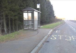
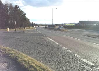
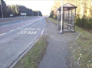
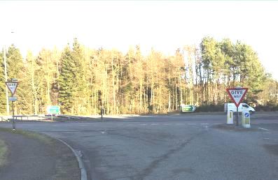
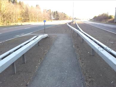
5 Page: Site Description & Existing Environment The A90 in this location is a strategic traffic route linking Tayside and Central Scotland with Aberdeen and the North East of Scotland. This is a staggered junction on the A90 trunk road approximately 4 kilometres north of the city of Dundee. A local road (C6) crosses through the A90 in this location linking the settlement of Tealing on the west side of the A90 with the travelling peoples site and Tealing Garage on the east side of the A90. Location Plan The northern junction within the stagger is known locally as the Tealing junction. The southern junction within the stagger is known locally as the Newbigging junction. For clarity this report will therefore address the northern junction as the Tealing junction and the southern junction as the Newbigging junction. The speed limit in this section is 70mph and the alignment and visibility on the A90 within this section is good. There are two bus lay-bys within the site. One on the northbound A90 just north of the staggered junction and one on the A90 southbound in the middle of the staggered junction. Both bus stops have raised bus boarder kerbing and a bus shelter.
6 Page: 5 There is a footway on the northbound A90 for the full length of the staggered junction. This is link to the bus lay-by on the southbound A90 with an uncontrolled crossing with dropped kerbs and a staggered barrier layout to negotiate the central reserve barriers. There is no property with direct access onto the A90 in this location. The traffic flows on this section of the A90 are approximately 12,000 (AADF) in each direction (Total two way AADF 24,000). The percentage of HGV is approximately 17%. The map overleaf gives a summary of all the features described above:

7 Page: 6 Forfar N Tealing Travelling People Site C6 Tealing junction A 90 C6 Tealing Garage Newbigging junction Dundee
8 Page: Accident Analysis 4.1 Injury accident details from 2007 to 2011 have been reviewed and are contained in Appendix A and B. The time period analysed has been extended to 5 years from the 3 year period which was initially used to identify this location in the moving cursor programme. This is because the accident patterns have continued over the subsequent two years and it is thought to be prudent to include these additional accidents and give a more holistic view of the accident patterns in this location. Of the 8 accidents that occurred in the vicinity of this junction, 75% (6) involved a vehicle emerging from a side road and turning right. Five of these accidents were involving vehicles emerging from the C6 on the east side of the A90 and turning right onto the northbound A90. 38% (3no.) of the accidents within the scheme extents involved drivers that were aged This is higher than the national average which is 25% (Reported Road Casualties Scotland 2010, Table 18a.) 38% (3no.) of the accidents within the scheme extents involved drivers that were aged 60 and over. This is higher than the national average which is 11.8% (Reported Road Casualties Scotland 2010, Table 18a.) Of the 8 injury accidents that occurred in the vicinity of the junction, 2 (25%) occurred during wet road conditions. This is far less than the national average proportion of wet road injury accidents (38% - Reported Road Casualties Scotland 2010, Table 7.) One of the 8 injury accidents (13%) occurred during the hours of darkness. This is a lower than the national average proportion of darkness injury accidents (28%) - Reported Road Casualties Scotland 2010, Table 7.) 4.2 Chi2 tests were carried out on possible patterns identified through analysis of the injury accident records. This statistical test helps to identify whether an overrepresentation of an accident type, against control data, is due to site specific issues or random fluctuation. The control data used for this particular analysis was taken from Reported Road Casualties Scotland Tests identified a very high level of confidence that there are site specific reasons for accidents involving right turning manoeuvres and an acceptable level of confidence that there are site specific reasons for accidents involving drivers aged 60 and over. No other relevant trends were highlighted by the analysis. A summary of the analysis undertaken is presented in Appendix C.
9 Page: 8 The accident times have been analysed and plotted to show any trends. This, as expected, has shown that the accidents are more likely to occur around peak times when traffic flows are at their highest. At this time drivers will have to show more patience to wait for a safe gap in the traffic and are more likely to take risks and turn right onto the A90 when there is not a safe gap in the traffic. Accident Times 00:00:00 22:00:00 20:00:00 18:00:00 EVENING PEAK 16:00:00 Time of Accident 14:00:00 12:00:00 10:00:00 08:00:00 Series1 06:00:00 MORNING PEAK 04:00:00 02:00:00 00:00: Accident Number 4.3 It is clear from the accident analysis that there is an issue at this location with vehicles making the right turn manoeuvre. From the accident plot in appendix B it is clear that vehicles emerging from the Newbigging junction present most significant road safety risk. For consistency however, it is recommended that any treatment provided is also provided to the Tealing junction. The accident analysis also indicates that there may be an issue with elderly drivers using these junctions. This should be considered when implementing any accident remedial measures.

10 Page: SCRIM data has been obtained from webseris. This shows that generally the carriageway skid resistance is above investigatory levels other than the northbound approach to the Tealing junction and the southbound approach to the Newbigging junction: A plan showing the processed SCRIM summary None of the 8 injury accidents involved a vehicle skidding. This demonstrates that the skid resistance of the carriageway is not a contributory factor in the accidents that are occurring at this location. Improvement of the skid resistance would therefore not provide a return in accident savings in this location. On visual investigation of the road surface at this location there does not appear to be any polishing in the wheel tracks or other signs that there is a skidding resistance issue in this area. Surface course treatment is therefore not recommended at this time. The site will, however, continue to be monitored through the annual moving cursor programme.

11 Page: Improvement Options 5.1 Problem Identified: There is a traffic sign in the central reserve immediately to the south of the Newbigging junction that is blocking visibility for traffic emerging form the side road and turning right on the northbound A90. The location of this issue coincides with the majority of the accidents involving right turning vehicles (6 / 7). A photograph looking south and showing the sign. Possible Solution: The sign should be removed and relocated out with the visibility splay for this junction. This will improve the visibility for vehicles emerging from the Newbigging junction and turning right.
 on approach to the junction from")


12 Page: Problem Identified: The advanced directional signing (ADS) on approach to the junction from both north and south on the A90 does not give warning to drivers that they are approaching a staggered junction where there is likely to be right turning traffic emerging. Existing ADS on approach to this junction Possible Solutions: a. Provision of new map type ADS showing the true staggered junction layout. Example of map type ADS that could be used b. Provision of Vehicle Activated Signs on the A90 on approach to the junction warning road users when there is a vehicle emerging onto the A90 from a side road*. Example of VAS signage that could be used c. Provision of a standard hazard marker post / bollard layout at both of the gaps in the central reserve to highlight the presence of the junction to road users (See Appendix D). *This option would be subject to approval of a non-standard sign by Transport Scotland.

13 Page: Problem Identified: Signing on approach to the A90 from Tealing on the C6 local road is poor and does not give drivers a clear indication that they are approaching a high speed dual carriageway. Photograph from the C6 local road looking east towards the A90. Possible Solution: a. Replace the existing give way signs with new signs of a consistent size and to correct mounting height with advanced warnings that drivers are approaching a dual carriageway. Examples of revised give way signage b. Install a cross with care sign opposite the junction to encourage drivers to wait for a safe gap before turning right onto the A90*. Example of cross with care sign *This option would be subject to approval of a non-standard sign by Transport Scotland.

14 Page: Problem Identified: Similar to the issue described above, signing on approach to the A90 from Newbigging on the C6 local road is poor and does not give drivers a clear indication that they are approaching a high speed dual carriageway. Photograph from the C6 local road looking west towards the A90 Possible Solution: a. Replace the existing give way signs with new signs of a consistent size and to correct mounting height with advanced warnings that drivers are approaching a dual carriageway. Examples of revised give way signage b. Install a cross with care sign opposite the junction to encourage drivers to wait for a safe gap before turning right onto the A90*. Example of cross with care sign *This option would be subject to approval of a non-standard sign by Transport Scotland.

 to")
15 Page: Problem Identified: Two diagram 610 keep left arrows are not lit. These should be lit as per the Traffic Signs Regulations and General Directions. Existing diagram 610 sign not lit Possible Solution: Replace sign and provide lighting supply and lighting unit to sign. 5.6 Problem Identified: Various signs are at incorrect mounting height. Most notably the signs in the vicinity of a junction which should be mounted at a minimum of 2 metres to maximise visibility for road users. Example of incorrect mounting height Possible Solution: Replace signage at incorrect mounting height with new signs to correct mounting height and with high reflectivity (micro prismatic) to ensure they are clearly visible and no not impede visibility at these junctions.
 met representatives of the local community and Insp. Grant Edward of Tayside Police on the XXXXXX to discuss this issue. As a result this study has been extended to include the Inveraldie junction.")

16 Page: Inveraldie Junction 6.1 Concerns have been raised by the local community regarding road safety on the A90 at Inveraldie. Alan Campbell (BEAR Scotland Ltd.) met representatives of the local community and Insp. Grant Edward of Tayside Police on the XXXXXX to discuss this issue. As a result this study has been extended to include the Inveraldie junction. 6.2 A further meeting was then held on the 19 th April 2012 between Ross Fletcher (BEAR Scotland Ltd.) and Insp. Grant Edward of Tayside Police to discuss which improvements would be practical, affordable and beneficial in this area. The main discussion points and recommendations are summarised below: 6.3 On approach from the south on the northbound A90 the junction is not very visible. There are large trees adjacent to the junction on the west side which block visibility of the junction and the directional sign for northbound traffic. Photographs looking north showing the poor visibility of the junction It is therefore proposed to replace the existing signs with larger signs with a more appropriate x-height for this location. The signs will also be re-located into the correct positions in the central reserve. This will prevent future issues with the tree growth obstructing visibility of the signs.

17 Page: The existing advanced directional signage for southbound traffic on the A90 is not well positioned. It is too close to the junction and does not give drivers enough prior warning that they are approaching a junction. It is also at the wrong mounting height. Photograph looking south showing ADS and its close proximity to the junction It is proposed to replace the southbound advanced warning sign with a new sign in a more appropriate location at the correct mounting height. The sign will be moved further north and located in the verge. This will give southbound road users more advanced warning that they are approaching a junction. 6.5 To highlight the presence of the junction further it is recommended to install a standard bollard and hazard marker post layout. These are shown in appendix D. 6.6 The recent accident history ( ) for this location has been researched. This has highlighted only one injury accident at the Inveraldie junction (25/05/2009). This was on the southbound A90 and involved a vehicle striking an animal therefore it cannot be attributed to the junction layout. The improvements will not therefore provide a measurable accident saving in this location, however the improvements are relatively minor (approximate cost 3,000) therefore it would be prudent to implement these improvements at the same time as the Tealing junction improvements. This will provide consistency in signing on this section of the A90 and address the concerns of the local community.
18 Page: Recommendations It is recommended that a complete sign revision is carried out at this location. This will include: Removal of the sign discussed in 6.1 from the central reserve. This will improve visibility for road users emerging from the Newbigging junction and turning right. Provision of map type ADS as part of the overall sign revision as discussed in 6.2b. This will give A90 road users a clear indication of the road layout ahead. Provision of a standard central reserve gap treatment as discussed in 6.2c. This will highlight this junction and the gap to road users on the A90. Provision of improved give way signage as part of the overall sign revision as discussed in 6.3a and 6.4a. This will ensure that drivers on the C6 from both directions are well informed of the road layout ahead. Provision of a CROSS WITH CARE sign opposite the side roads at both the Tealing junction and the Newbigging junction. This will give a strong message to road users wishing to turn right that they should wait for a safe gap and cross with due care (as part of the overall signing revision). Replacement of the existing diagram 610 signs at the central reserve gaps and ensuring that they are all lit as per the current legislative requirements (as part of the overall signing revision). Replacement of all signs that are in the vicinity of the junction and are not at the correct mounting height. This will ensure that all traffic signs are at a consistent mounting height and are not blocking the visibility of road users. The estimated cost of these proposals is 36,000 for construction and the first year rate of return is 143%. The revision of signage throughout the staggered junction will also aid elderly drivers in this location (drivers over 60 was one of the common trend identified in the accident analysis). It is known that drivers over the age of 60 can often take longer to process the information available through traffic signage. It will therefore be of great benefit to clarify the signage provided and ensure it si of a consistent standard. The proposal for VAS on the A90 on both approaches to this location has been considered. It is thought that since there are significant other signing improvements that can be made in this location, the VAS should not be included at this time. It is recommended that the VAS is retained as a further option if the above recommendations do not yield that desired accident reductions. It is proposed to install the improvements at Inveraldie junction as discussed in section 6 of this report.
19 Page: Conclusion It is recommended that the proposals discussed in 7.0 are implemented in 2012/13. It is believed that these proposals will give clarity on the road layout ahead to road users on the A90 and also ensure that road users on the side road approaches to the A90 are well informed of the dual carriageway ahead. The site will continue to be monitored through the Moving Cursor Programme and should the desired accident savings not be achieved then a further review should be carried out with a view to installing Vehicle Activated Signage.
20 Appendix A Injury Accident Details
21 Appendix B Damage Only Accident Details
22 Appendix C Accident Drawings
23


24
25 Appendix D Chi Squared Analysis
26 Ross Fletcher 09/03/12 11/NE/0805/278 A90 Tealing Chi Squared Analysis All NE Dual Carriageway Accidents as Control Site single Control Chi Sq significance Confidence Interpretation All Accidents Serious/Fatal Slight Dark Non Dark Single Vehicle Non Single Vehicle Casualty age Non Casualty age Casualty age Casualty age Pesdestrian casualty collisions Non Pesdestrian casualty collisions Pesdestrian casualty 0 35 collisions (0-16 child) Non Pesdestrian casualty collisions (0-16 Involving Agricultural 0 40 vehicles Non Involving Agricultural vehicles Involving All goods vehicle Non Involving All goods vehicle Involving All moped and motorcylce Non Involving All moped and motorcylce Involving Pedal Cycle 0 59 Non Involving Pedal Cycle Road surface wet/damp Non Road surface wet/damp Involving Right Turn manouvres Non Involving Right Turn manouvres not significant # # 0.38 not significant # # 0.85 not significant # # 0.03 not significant # # % 95% Acceptable 0.00 not significant # # 1.16 not significant # # 0.92 not significant # # 0.85 not significant # # 0.05 not significant # # 0.42 not significant # # 0.49 not significant # # % 100% Definite!!!
27 Ross Fletcher 09/03/12 11/NE/0805/278 A90 Tealing Chi Squared Analysis All NE Accidents as Control Site single Control Chi Sq significance Confidence Interpretation All Accidents Serious/Fatal Slight Dark Non Dark Single Vehicle Non Single Vehicle Casualty age Non Casualty age Casualty age Casualty age Pesdestrian casualty collisions Non Pesdestrian casualty collisions Pesdestrian casualty 0 28 collisions (0-16 child) Non Pesdestrian casualty collisions (0-16 Involving Agricultural 0 37 vehicles Non Involving Agricultural vehicles Involving All goods vehicle Non Involving All goods vehicle Involving All moped and motorcylce Non Involving All moped and motorcylce Involving Pedal Cycle 0 45 Non Involving Pedal Cycle Road surface wet/damp Non Road surface wet/damp Involving Right Turn manouvres Non Involving Right Turn manouvres not significant # # 0.61 not significant # # 0.91 not significant # # 0.03 not significant # # 1.14 not significant # # 0.02 not significant # # 1.97 not significant # # 1.30 not significant # # 0.91 not significant # # 0.01 not significant # # 0.94 not significant # # 0.99 not significant # # % 100% Definite!!!
28 Appendix E Central Reserve Treatment Drawings

29
30 Appendix F FYRR for Recommended Treatment Treatment: Revision of junction signage and provision of central reserve treatment at Tealing junction. No of injury accidents at this location: 8no. ( ) Cost of proposals: 36, Cost of Design: 5, Total Scheme Cost: 41, %FYRR = Annual Collision Savings * 100 Scheme Cost Annual Collision Reduction = 30% (Table 5.1 RoSPA Road Safety Engineering Manual) = 0.3 * 8 accidents = 2.4 accidents => Accidents saved per year = 2.4 / 5 = 0.48 accidents. Average Injury Accident Cost = 122,490 (Table 10 of Reported Road Casualties Scotland 2010) => Annual Collision Savings = 0.48 * 122,490 = 58, %FYRR = * = 143%
TERM CONTRACT FOR THE MANAGEMENT AND MAINTENANCE OF THE SCOTTISH TRUNK ROAD NETWORK NORTH EAST UNIT
 TERM CONTRACT FOR THE MANAGEMENT AND MAINTENANCE OF THE SCOTTISH TRUNK ROAD NETWORK NORTH EAST UNIT A90 LAURENCEKIRK ROAD SAFETY SCHEME MONITORING STUDY Client: Transport Scotland Trunk Road and Bus Operations
NORTH EAST UNIT 17/NE/0801/013. A90 Tealing Junction. Accident Investigation Study
 NORTH EAST UNIT 17/NE/0801/013 A90 Tealing Junction Accident Investigation Study This is an unpublished report prepared for the Transport Scotland, Trunk Road and Bus Operations Directorate (TRBO) and
SLOUGH Stage 3 Road Safety Audit of A4 London Road, M4 J5 to Sutton Lane
 SLOUGH Stage 3 Road Safety Audit of A4 London Road, M4 J5 to Sutton Lane Exception Report Client Officer Rudo Beremauro Date 20 January 2015 RSA /Project Sponsor s Contents Section 3 Project Sponsor's
Kings Road, Herne Bay: Proposed Crash Remedial Measure
 Kings Road, Herne Bay: Proposed Crash Remedial Measure To: Canterbury Joint Transportation Board 17 February 2015 By: Classification: Ward: Tim Read - Head of Transportation Unrestricted Herne Bay Summary:
Collision Site Investigation - Bodenham By-Pass Background
 Collision Site Investigation - Bodenham By-Pass Background The junction of the C12 and A338 was the subject of a Local Safety Scheme (LSS) in 2011. Analysation of the collisions at the time revealed the
Strategic Director for Environment. Enclosures Appendix A - Option drawings. Jamie Blake- Strategic Director for Environment
 Chipping Barnet Area Committee 9 July 2018 Title Report of Wards Status Urgent Key Cromer Road Request for 20mph Zone Strategic Director for Environment High Barnet Public No No Enclosures Appendix A -
DESIGN CODE. Enterprise West Harlow London Road North Design Code 21
 DESIGN CODE Enterprise West Essex @ Harlow London Road North Design Code 21 4 MAXIMUM BUILDING HEIGHTS 4.1 Table 4A sets out maximum building height standards for each character area within the LDO boundary.
Speed Limit Policy Isle of Wight Council
 APPENDIX B Speed Limit Policy Isle of Wight Council 2009 Contents Section 1 Introduction 1.1 Links with the Local Transport Plan Section 2 Speed Limits on Urban Roads and Residential Areas 2.1 20mph Limits
To: The results of these surveys have been analysed and are summarised within this Technical Note.
 Technical Note Project: Histon Road / Milton Road, Cambridge Parking Surveys To: Andy Harrison Subject: Survey Report v1.6 From: Jonathan Barlow Date: 18 th February 2016 cc: Richard Jones / Dave Boddy
Rhebogue Neighbourhood Greenway. Road Safety Audit Stage 2
 Rhebogue Neighbourhood Greenway Road Safety Audit Stage 2 Report Number: 12/007/00/00057 July 2014 Mid West National Road Design Office Lissanalta House, Dooradoyle County Limerick Tel: 061 496 800 Fax:
A105 Green Lanes junction with Bourne Hill / Hedge Lane
 Cycle Enfield - Section 5 A105 Green Lanes junction with Bourne Hill / Hedge Lane Stage 2 Road Safety Audit Ref: 2759.03.05/032/A105/BOR/2016 Prepared for: London Borough of Enfield By: Road Safety Audit,
Cabinet Member for Highways & Streetscene. Highway Infrastructure Manager
 LONDON BOROUGH OF RICHMOND UPON THAMES DATE: AUGUST 2015 DECISION MAKER: LEAD OFFICER: SUBJECT: WARDS: Cabinet Member for Highways & Streetscene Highway Infrastructure Manager PROPOSED CYCLING IMPROVEMENTS
MILTON ROAD ~ MITCHAM'S CORNER PARAMICS MODEL INITIAL OPTION TESTING
 MILTON ROAD ~ MITCHAM'S CORNER PARAMICS MODEL INITIAL OPTION TESTING NOVEMBER 216 MILTON ROAD ~ MITCHAM'S CORNER PARAMICS MODEL INITIAL OPTION TESTING Cambridgeshire County Council Type of document (version)
PUBLISHED PROJECT REPORT PPR850. Optimisation of water flow depth for SCRIM. S Brittain, P Sanders and H Viner
 PUBLISHED PROJECT REPORT PPR850 Optimisation of water flow depth for SCRIM S Brittain, P Sanders and H Viner Report details Report prepared for: Project/customer reference: Copyright: Highways England,
APPENDIX F: TECHNICAL NOTE 22 (VICARAGE ROAD JUNCTION)
") APPENDIX F: TECHNICAL NOTE 22 (VICARAGE ROAD JUNCTION) West Midlands Interchange Transport Assessment DCO Submission WEST MIDLANDS INTERCHANGE SUBJECT: Technical Note 22 Review of Vicarage Road Junction
APPENDIX F: TECHNICAL NOTE 22 (VICARAGE ROAD JUNCTION) West Midlands Interchange Transport Assessment DCO Submission WEST MIDLANDS INTERCHANGE SUBJECT: Technical Note 22 Review of Vicarage Road Junction
CAIRNGORMS NATIONAL PARK AUTHORITY FOR DECISION
 CAIRNGORMS NATIONAL PARK AUTHORITY FOR DECISION Title: Prepared by: A9 Dualling Project: Dalraddy to Slochd Murray Ferguson, Director of Planning and Rural Development and Gavin Miles, Head of Planning
Skid Resistance Policy. July 2008
 July 2008 JOB NUMBER: DOCUMENT REF: Rev 4 Rev 3 Rev 2 Rev 1 1 st Draft AT KH Revision Purpose Description Originate Checked Review Authorised Date Safer Roads, Better Journeys Page 1 of 13 1.0 Introduction
Audit No. RSA Stage 1 Road Safety Audit Bermuda Park, Nuneaton Getting West Nuneaton Moving: Bermuda Connection
 Audit No. RSA 2199 Stage 1 Road Safety Audit Bermuda Park, Nuneaton Getting West Nuneaton Moving: Bermuda Connection 1 1.0 INTRODUCTION 1.1 This report results from a Stage 1 Road Safety Audit for a highways
SH1, Karo Drive Wellington Crash Reduction Study
 SH1, Karo Drive Wellington Crash Reduction Study A REPORT PREPARED FOR New Zealand Transport Agency Reference: 12334 January 2013 Hawke s Bay office: PO Box 28 208, Havelock North 4157 Tel: (06) 877 8040
Traffic Assets Section Proposed Removal of Street Lighting Road Safety Review Report No 48
 Street Lighting Section Unique Reference: o. 48 Traffic Assets Section Report o 48 Reviewer: Ellie Briggs, BEng (Hons) CEng MICE Highway Classification / umber Road / Street ame: District / Settlement:
M42 MM Monitoring and Evaluation
 Highways Consultancy Group - Highways Research Group M42 MM Monitoring and Evaluation Three Year Safety Review Task Reference: 292(1308)MOTT Project Sponsor: Steve Self Report Date: January 2011 This report
Local Highway Panels Members Guide. 5 Crossing Facilities
 Local Highway Panels Members Guide 5 2 Local Highway Panels (LHP) Members Guide 2016/17 1. Introduction On the Network where there are sufficient crossing opportunities most individuals are able to cross
Issues at T junctions:
 TheSlade_PublicConsulationPlans_March2017.pdf These comments relate to junction designs in this phase of the project on The Slade. Comments begin with the northernmost junction: Girdlestone Rd and continue
Traffic calming regulations (Scotland)
") Traffic Advisory Leaflet 11/94 December 1994 Traffic calming regulations (Scotland) Introduction Traffic calming can help drivers to make their speeds appropriate to local conditions, through measures
Traffic Advisory Leaflet 11/94 December 1994 Traffic calming regulations (Scotland) Introduction Traffic calming can help drivers to make their speeds appropriate to local conditions, through measures
Regional Cycle Programme Update
 Agenda Item 10 (ii) Regional Cycle Programme Update Glossary Auckland Council Auckland Transport Cycle Action Auckland New Zealand Transport Agency Regional Cycle Network (AC) (AT) (CAA) (NZTA) (RCN) Executive
Appendix 12 Parking on footways and verges
 Appendix 12 Parking on footways and verges Legal position Parking on footways and verges whether wholly or partly is banned throughout London, unless signs are placed to allow parking. The ban requires
Appendix F CAPITA Technical Audit
 Appendix F CAPITA Technical Audit West Hendon - Major Review of Technical Audit Responses 14 June 2016 Quality Management Quality Management Job No Project Location Title CS/086106 West Hendon - Major
Appendix A Type of Traffic Calming Measures Engineering Solutions
 Appendix A Type of Traffic Calming Measures Engineering Solutions PHYSICAL MEASURES Central Hatching The major consideration of this feature is that, these markings can only be laid down the centre of
Research for MfS2 High Risk Collision Sites and Y Distance Visibility
 Research for MfS High Risk Collision Sites and Y Distance Visibility Date: September Vanguard Centre, University of Warwick Science Park, Sir William Lyons Road, Coventry CV EZ Tel: + () Fax: + () Email:
Design and Installation of Low Level Cycle Signals
 Transport for London Surface Transport Management System Document Guidance Note Design and Installation of Low Level Cycle Signals Document reference: SQA-0651 - Issue: Draft out of date information. 1
Road Safety Audits of Traffic Signal Schemes
 Road Safety Audits of Traffic Signal Schemes David Prior Waterman Infrastructure & Environment Abstract This paper examines the following elements of Road Safety Audits (RSAs) of traffic signal schemes:
MEETING CHIPPING BARNET AREA ENVIRONMENT SUB-COMMITTEE DATE AND TIME WEDNESDAY 13 MARCH, 2013 AT 7.00 PM VENUE 1255 HIGH ROAD, WHETSTONE, N20 0EJ
 MEETING CHIPPING BARNET AREA ENVIRONMENT SUB-COMMITTEE DATE AND TIME WEDNESDAY 13 MARCH, 2013 AT 7.00 PM VENUE 1255 HIGH ROAD, WHETSTONE, N20 0EJ Dear Councillors, Please find enclosed additional papers
Improving Cyclist Safety at the Dundas Street West and Sterling Road Intersection
 STAFF REPORT ACTION REQUIRED Improving Cyclist Safety at the Dundas Street West and Sterling Road Intersection Date: August 17, 2012 To: From: Wards: Reference Number: Public Works and Infrastructure Committee
Setting Local Speed Limits. A review of recent installations of 20mph area schemes (signage only).
.") Setting Local Speed Limits A review of recent installations of 20mph area schemes (signage only). 1 Setting Local Speed Limits A review of recent 20mph area scheme installations. Contents. Background to
Setting Local Speed Limits A review of recent installations of 20mph area schemes (signage only). 1 Setting Local Speed Limits A review of recent 20mph area scheme installations. Contents. Background to
Streets for All : 9 Use of white lines
 Streets for All : 9 Use of white lines On 1st April 2015 the Historic Buildings and Monuments Commission for England changed its common name from English Heritage to Historic England. We are now re-branding
NRA New Divided Road Types: Type 2 and Type 3 Dual - Carriageways
 NRA New Divided Road Types: Type 2 and Type 3 Dual - Carriageways DN-GEO-03059 December 2007 DN Design Technical TRANSPORT INFRASTRUCTURE IRELAND (TII) PUBLICATIONS About TII Transport Infrastructure Ireland
Mill Hill Broadway Capacity Improvement
 1 16 MARCH 2016 Mill Hill Broadway Capacity Improvement Presentation to Barnet Members and Mill Hill Residents Association 2 Background A1 is one of 23 Transport for London Road Network (TLRN) Strategic
road safety issues 2001 road toll for Gisborne district July 2002 Road user casualties Estimated social cost of crashes*
 GISBORNE DISTRICT road safety issues July 22 The Land Transport Safety Authority (LTSA) has prepared this Road Safety Issues Report. It is based on reported crash data and trends for the 1997 21 period.
B9097 Route Action Plan
 B997 Route Action Plan Map - B997 Route (highlighted in red). BACKGROUND. The number 9 prefix locates the B997 in Zone 9 of the UK road numbering system focused on the North East of Scotland, north of
The Cabinet Member for Highways & Streetscene. Aurang Zeb - Head of Highways & Transport
 LONDON BOROUGH OF RICHMOND UPON THAMES Cabinet Member Decision DATE: January 2012 REPORT OF: LEAD OFFICER: SUBJECT: WARDS: The Cabinet Member for Highways & Streetscene Aurang Zeb - Head of Highways &
Chapter 8 (2009) - Summary of key changes
 - Summary of key changes") Chapter 8 (2009) - Summary of key changes (Some sections and paragraphs in the revised edition have been renumbered to take account of new sections and paragraphs; section numbers below refer to the revised
Chapter 8 (2009) - Summary of key changes (Some sections and paragraphs in the revised edition have been renumbered to take account of new sections and paragraphs; section numbers below refer to the revised
INTERIM ADVICE NOTE 188/16
 INTERIM ADVICE NOTE 188/16 Guidance on Omission of Warning Lights (Road Danger Lamps) for Relaxation Works on Dual Carriageways Summary Guidance for omission of warning lights (road danger lamps) in temporary
Public Consultation on Braintree Integrated Transport Package (ITP) HAVE YOUR. Consultation open from 24 September to 5 November 2018 SAY
 HAVE YOUR. Consultation open from 24 September to 5 November 2018 SAY") Public Consultation on Braintree Integrated Transport Package (ITP) HAVE YOUR SAY Consultation open from 24 September to 5 November 2018 Contents Introduction 3 Background 4 Springwood Drive Roundabout
Public Consultation on Braintree Integrated Transport Package (ITP) HAVE YOUR SAY Consultation open from 24 September to 5 November 2018 Contents Introduction 3 Background 4 Springwood Drive Roundabout
Introduction Methodology Study area and data collection Results and recommendation Conclusion References
 Introduction Methodology Study area and data collection Results and recommendation Conclusion References It is formal procedure for assessing accident potential and safety performance in the provision
NRA New Divided Road Types: Type 2 and Type 3 Dual-carriageways
 NRA New Divided Road Types: Type 2 and Type 3 Dual-carriageways BENEFITS of the TYPE 2 and TYPE 3 DUAL CARRIAGEWAY ROAD TYPE There are significant safety and economic benefits associated with the Type
Traffic Calming Regulations
 Traffic Advisory Leaflet 7/93 August 1993 Traffic Calming Regulations Introduction Traffic calming can help drivers to make their speeds appropriate to local conditions, through measures which are self-enforcing.
LEA BRIDGE ROAD - A STREET FOR EVERYONE Public consultation document
 LEA BRIDGE ROAD - A STREET FOR EVERYONE Public consultation document TELL US Bakers Arms to Leyton Green Road (Section D, E, F) Leyton Green Road to Whipps Cross Roundabout (Section G) YOUR VIEWS www.enjoywalthamforest.co.uk
TS 109 DURHAM ROAD QTC PHASE 4 PROJECT PROPOSAL. Page 1
 TS 109 DURHAM ROAD QTC PHASE 4 PROJECT PROPOSAL Page 1 Table of Contents 1.0 Introduction... 3 2.0 Project Overview... 3 3.0 Project Proposals... 4 3.1 Enfield Road / Durham Road Junction... 3 5 3.2 Summerfield
Lincolnshire JSNA: Road Traffic Accidents
 Road Traffic Accidents What do we know? Summary A higher proportion of road traffic collisions in Lincolnshire result in death compared to other areas. This may be due to the types of road in the County
Draft letter to Designers and Managing Agents INTERIM ADVICE NOTE 43/02: CANTILEVER AND PORTAL GANTRY VMS
 Draft letter to Designers and Managing Agents INTERIM ADVICE NOTE 43/02: CANTILEVER AND PORTAL GANTRY VMS This Interim Advice Note announces amendments to a series of guidelines related to cantilever and
Essential Standard No. 16. Streetworks - Short duration static works carried out from a vehicle
 Key Messages Short duration static works must not exceed 60 mins, including setting up and dismantling traffic management. A vehicle or vehicles should be used whenever possible to protect the workforce.
ACCIDENT ANALYSIS ON RURAL ROADS A TECHICAL GUIDE
 TRL Limited PUBLISHED PROJECT REPORT PPR026 ACCIDENT ANALYSIS ON RURAL ROADS A TECHICAL GUIDE Version: 1 By TRL Limited Prepared for: Project Record: S410K Client: Road Safety Division, Department for
A105 South of Ecclesbourne Gardens to Oakthorpe Road
 Cycle Enfield - Section 1 A105 South of Ecclesbourne Gardens to Oakthorpe Road Stage 2 Road Safety Audit Ref: 2759.03.01/032/A105/BOR/2016 Prepared for: London Borough of Enfield By: Road Safety Audit,
Road Safety. Inspections
 Title of your presentation Road Safety Name and contact details Inspections Phil Allan Australiaame ROAD SAFETY SEMINAR Lome, Togo October 2006 Definition A Road Safety Inspection (RSI) is an on-site systematic
Cuddington Traffic Calming
 Buckinghamshire County Council Cuddington Traffic Calming PRIV18003 / FEA / DOC / 01 June 2018 Ringway Jacobs Ltd Harling House 47-51 Great Suffolk Street London SE1 0BS Tel: 02079604040 Fax: 02079604051
1 Monash University Accident Research Centre, Monash University, Victoria, RACV, 550 Princes Highway Noble Park, Victoria, 3174.
 Roadside Environment Safety: a statistical analysis of collisions with fixed roadside objects in Victoria Amanda Delaney 1, Stuart Newstead 1, Bruce Corben 1, Jim Langford 1 and Peter Daly 2 1 Monash University
Road Condition Statistics: Notes and definitions
 Road Condition Statistics: Notes and definitions This note provides definitions used for road condition statistics. It also includes useful information on the source of the data 1. Source The statistics
Process for managing parking on verges, footways and footpaths
 Process for managing parking on verges, footways and footpaths Author: MG/NR Highways and Transport Environment Department Date: 28 July 2015 Version: 2.0 PARKING ON VERGES, FOOTWAYS AND FOOTPATHS Introduction
Our Approach to Managing Level Crossing Safety Our Policy
 Our Approach to Managing Level Crossing Safety Our Policy Our policy towards managing level crossing risk is: that we are committed to reducing the risk at level crossings where reasonably practicable
TRIAL EVALUATION OF WIDE, AUDIO-TACTILE, CENTRELINE CONFIGURATIONS ON THE NEWELL HIGHWAY
 TRIAL EVALUATION OF WIDE, AUDIO-TACTILE, CENTRELINE CONFIGURATIONS ON THE NEWELL HIGHWAY Connell D.J., Smart W.J, Levett S., Cleaver M., Job R.F.S., de Roos M., Hendry T., Foster J., Saffron D... New South
Amendments to Essex Highway Maintenance Strategy Maintenance Policy and Standards April 2008
 Amendments to Essex Highway Maintenance Strategy Maintenance Policy and Standards April 2008 The following amendments to the wording of the maintenance strategy apply following the revised maintenance
ASSET MANAGEMENT & SCRIM: A TARGETED APPROACH TO THE MANAGEMENT OF SKIDDING RESISTANCE
 ASSET MANAGEMENT & SCRIM: A TARGETED APPROACH TO THE MANAGEMENT OF SKIDDING RESISTANCE Andrew Stevenson - Cornwall Council, UK Anuradha Premathilaka W.D.M. Limited, UK John Donbavand - W.D.M. Limited,
INTERIM ADVICE NOTE 98/07 GUIDANCE FOR HA SERVICE PROVIDERS ON IMPLEMENTING THE SKID RESISTANCE POLICY (HD28/04)
") INTERIM ADVICE NOTE 98/07 GUIDANCE FOR HA SERVICE PROVIDERS ON IMPLEMENTING THE SKID RESISTANCE POLICY (HD28/04) Summary This interim advice note provides guidance to facilitate the effective application
INTERIM ADVICE NOTE 98/07 GUIDANCE FOR HA SERVICE PROVIDERS ON IMPLEMENTING THE SKID RESISTANCE POLICY (HD28/04) Summary This interim advice note provides guidance to facilitate the effective application
2003 road trauma for. Wairoa District. Road casualties Estimated social cost of crashes* Major road safety issues WAIROA DISTRICT JULY 2004
 WAIROA DISTRICT JULY 24 T he Land Transport Safety Authority (LTSA) has prepared this road safety issues report. It is based on reported crash data and trends for the 1999 23 period. The intent of the
RIGHT TURNS AT INTERSECTIONS: ARE THERE ALTERNATIVES?
 RIGHT TURNS AT INTERSECTIONS: ARE THERE ALTERNATIVES? R.C. Pyke, J.D. Sampson and K.G. Schmid Stewart Scott International, P O Box 784506, Sandton, 2146 TTT Africa, P.O.Box 109, Sunninghill, G.D.P.T.R.W,
Cycling Safety Review. (April 2017)
") Cycling Safety Review (April 2017) Background Analysis of STATS19 database: - Only includes incidents where police were in attendance, or where the crash was subsequently reported to the police - Significantly
Cycling Safety Review (April 2017) Background Analysis of STATS19 database: - Only includes incidents where police were in attendance, or where the crash was subsequently reported to the police - Significantly
1 This technical note considers the issues associated with the use of tidal flow bus lanes on key public transport corridors in Cambridge.
 TECHNICAL NOTE: TIDAL FLOW BUS LANE OPTION ASSESSMENT Purpose 1 This technical note considers the issues associated with the use of tidal flow bus lanes on key public transport corridors in Cambridge.
Road Safety Factsheet
 Road Safety Factsheet Overtaking July 2017 Overtaking is one of the highest risk manoeuvres for both drivers and riders because it can put the overtaking vehicle into the path of oncoming traffic, often
London Safety Camera Partnership
 London Safety Camera Partnership Between 2001 and 2003 over 17,000 speed related collisions occurred in London, of which 2,000 people lost their lives or were seriously injured. Excessive and inappropriate
Walking and Cycling Action Plan Summary. A Catalyst for Change The Regional Transport Strategy for the west of Scotland
 Walking and Cycling Action Plan Summary A Catalyst for Change The Regional Transport Strategy for the west of Scotland 2007-2021 Strathclyde Partnership for Transport Contents Purpose...2 Issues, Constraints
Bus and Transit Lane Review Update
 Board Meeting / 25 February 2013 Agenda Item no.8(i) Bus and Transit Lane Review Update Glossary Auckland Transport New Zealand Transport Agency Transit Two Transit Three (AT) (NZTA) (T2) (T3) Executive
Raised Rib Markings. Traffic Advisory Leaflet 2/95 March Introduction
 Traffic Advisory Leaflet 2/95 March 1995 Raised Rib Markings Introduction Raised rib markings consist of a continuous line marking with ribs across the line at regular intervals. They were first specially
INTERIM ADVICE NOTE 150/14 Revision 02. Guidance on Alternative Temporary Traffic Management Techniques for Relaxation Works on Dual Carriageways
 INTERIM ADVICE NOTE 150/14 Revision 02 Guidance on Alternative Temporary Traffic Management Techniques for Relaxation Works on Dual Carriageways Summary Guidance for temporary traffic management (TTM),
Frequently asked questions (FAQ) about a borough-wide 20 mph speed limit
 about a borough-wide 20 mph speed limit") Frequently asked questions (FAQ) about a borough-wide 20 mph speed limit February 2013 1. Is it safer to drive at 20 mph? Yes. According the Royal Society for Prevention of Accidents (RoSPA) if a pedestrian
Frequently asked questions (FAQ) about a borough-wide 20 mph speed limit February 2013 1. Is it safer to drive at 20 mph? Yes. According the Royal Society for Prevention of Accidents (RoSPA) if a pedestrian
MACKA S SAND PTY LTD
 MACKA S SAND PTY LTD ROAD SAFETY AUDIT STAGE 2 PRELIMINARY DESIGN OF CHANNELISED INTERSECTION OF ACCESS ROAD TO TO PROPOSED SAND MINING DEVELOPMENT AT LOT 218, D.P. 1044608, WILLIAMTOWN AND NELSON BAY
Transportation Consultants. Construction Consultants PROPOSED RESIDENTIAL DEVELOPMENT ON LAND AT WILBURTON ROAD, HADDENHAM TRANSPORT ASSESSMENT
 PROPOSED RESIDENTIAL DEVELOPMENT ON LAND AT WILBURTON ROAD, HADDENHAM TRANSPORT ASSESSMENT Client: Gladman Developments Ltd February 2014 Transportation Consultants Woolstone Centre, 1-2 Mill Lane, Woolstone,
Parking. Signing. Appendix C Typical detail drawings. London Cycling Design Standards
 Appendix C Typical detail drawings London Cycling Design Standards All drawings are prefixed CCE/ General A1 Cycle Symbol Diagram 1057 165 A3 Raised entry treatment on side roads 166 A4 Raised table at
INTERIM ADVICE NOTE 150/12. Guidance for Alternative Temporary Traffic Management Techniques for Relaxation Schemes on Dual Carriageways.
 INTERIM ADVICE NOTE 150/12 Guidance for Alternative Temporary Traffic Management Techniques for Relaxation Schemes on Dual Carriageways Summary Guidance for temporary traffic management (TTM), on the approach
Frascati Road and Temple Hill Route Improvements. Outline Design Report to Accompany Public consultation
 Frascati Road and Temple Hill Route Improvements Outline Design Report to Accompany Public consultation September 2013 Background: Dún Laoghaire-Rathdown is committed to providing high quality pedestrian
How do we design for pedestrians? Case study: transforming the Walworth Road
 How do we design for pedestrians? Case study: transforming the Walworth Road David Moores, Director of Public Realm Institution of Highways and Transportation, November 2009 Presentation overview Design
Napier City road trauma for Napier City. Road casualties Estimated social cost of crashes* Major road safety issues.
 ISSN 1176-841X July 25 Land Transport New Zealand has prepared this road safety issues report. It is based on reported crash data and trends for the 2 24 period. The intent of the report is to highlight
CYCLING SCOTLAND SCOTTISH CHARITY NO.SCO Annual Cycling Monitoring Report
 CYCLING SCOTLAND SCOTTISH CHARITY NO.SCO29760 Annual Cycling Monitoring Report 2018 Annual Cycling Monitoring Report 2018 4 CYCLING SCOTLAND Annual Cycling Monitoring Report 2018 National cycling.scot
20mph Speed Limit Trial Warrington Borough Council. Mark Tune Traffic Management & Road Safety Manager
 20mph Speed Limit Trial Warrington Borough Council Mark Tune Traffic Management & Road Safety Manager Benefits of reduced speed Reduced number and severity of accidents More cycle friendly environment
LBPN Lambeth. Review of Clapham Park Road Eastbound Bus Lane
 LBPN Lambeth Review of Clapham Park Road Eastbound Bus Lane May 2007 LBPN Lambeth Review of Clapham Park Road, Eastbound Bus Lane JOB NUMBER: 4411274.514 DOCUMENT REF: Clapham Pk Rd - Bus Lane Review -
CHECKLIST 4: PRE-OPENING STAGE AUDIT
 CHECKLIST 4: PRE-OPENING STAGE AUDIT 4.1 General topics 4.1.1 Changes since previous audit; translation of design into practice General check: have any matters that have changed since a previous audit
A105 Oaktree Avenue to Carpenters Gardens
 Cycle Enfield - Section 6 A105 Oaktree Avenue to Carpenters Gardens Stage 2 Road Safety Audit Ref: 2759.03.06/032/A105/BOR/2016 Prepared for: London Borough of Enfield By: Road Safety Audit, TfL Asset
Findings on the Effectiveness of Intersection Treatments included in the Victorian Statewide Accident Black Spot Program
 Findings on the Effectiveness of Intersection Treatments included in the Victorian Statewide Accident Black Spot Program Nimmi Candappa, Jim Scully, Stuart Newstead and Bruce Corben, Monash University
Guide to the Cycle Enfield Public Consultation on Enfield Town. Produced by the Save Our Enfield Town Campaign Group
 Guide to the Cycle Enfield Public Consultation on Enfield Town Produced by the Save Our Enfield Town Campaign Group What s in this guide? Introduction Page 3 What Enfield Council says about Option 1 Page
Safer Verges and the Strategic Road Network
 Safer Verges and the Strategic Road Network Gavin Williams Senior Technical Advisor Vehicle Restraints Outline The Journey from Highways Agency to Highway England Overview of the Highways England Health
Harriet Fraser Traffic Engineering & Transportation Planning
 Appendix 5: Traffic Assessment 71 26 February 2015 Mr James Beban Senior Resource Consents Planner Cuttriss Consultants Ltd PO Box 30429 Lower Hutt PO Box 40170 Upper Hutt 5140 P 04 526 2979 M 027 668
Review of Collision Sites. Presented by: Forbes Vigors Date: 24 th Sep 2012 Venue: Engineers Ireland, Clyde Road
 Review of Collision Presented by: Forbes Vigors Date: 24 th Sep 2012 Venue: Engineers Ireland, Clyde Road Fatal Collision Where at least one person is killed as a result of the collision and death occurs
RESTRICTED ROADS (20 MPH SPEED LIMIT) (SCOTLAND) BILL. 1. Is reducing the speed limit to 20mph the best way of achieving the aims of the Bill?
 (SCOTLAND) BILL. 1. Is reducing the speed limit to 20mph the best way of achieving the aims of the Bill?") RURAL ECONOMY AND CONNECTIVITY COMMITTEE RESTRICTED ROADS (20 MPH SPEED LIMIT) (SCOTLAND) BILL SUBMISSION FROM CYCLE STIRLING Questions 1. Is reducing the speed limit to 20mph the best way of achieving
RURAL ECONOMY AND CONNECTIVITY COMMITTEE RESTRICTED ROADS (20 MPH SPEED LIMIT) (SCOTLAND) BILL SUBMISSION FROM CYCLE STIRLING Questions 1. Is reducing the speed limit to 20mph the best way of achieving
Urban Street Design with DMURS. Sean McGrath Senior Executive Engineer Fingal County Council
 Urban Street Design with DMURS Sean McGrath Senior Executive Engineer Fingal County Council Urban versus Rural Design Rural Road Design Prefer higher speed Release constraints Work within fence line Urban
HIGH STREET & ROYAL AVENUE TRAFFIC SURVEY
 HIGH STREET & ROYAL AVENUE TRAFFIC SURVEY On Behalf of Belfast City Centre Management 27 th March 2012 0 High Street & Royal Avenue Traffic Report Cover Image Courtesy of David Lloyd AECOM Design & Planning
DRAFT INTERIM ADVICE NOTE 150/17
 DRAFT INTERIM ADVICE NOTE 150/17 Guidance on Alternative Temporary Traffic Management Techniques for Relaxation Works on Dual Carriageways Summary Guidance for temporary traffic management (TTM), on the
DRAFT. Jesmond Vale Lane. Meldon Terrace. Heaton Road. King John Street. Newcastle City Council
 Remove footway build-out and reposition crossing equipment & tactile paving uild-out kerb to reduce turning speeds Jesmond Vale Lane Provide gap in parking for right turning cycles Light segregation set-back
PART 5 TD 51/17 SUMMARY
 DESIGN MANUAL FOR ROADS AND BRIDGES VOLUME 6 SECTION 3 ROAD GEOMETRY HIGHWAY FEATURES PART 5 TD 51/17 SEGREGATED LEFT TURN LANES AND SUBSIDIARY DEFLECTION ISLANDS AT ROUNDABOUTS SUMMARY This document sets
AT403.1 Ancient monument Note 3 amended P500 Basic triangle New size 1800mm added
 AT403.1 P666 P874 P1028.4 P2509.1 P5001.2 P500 P672 P875 P1032 P2511.1 P5010 P530A P673 P876 P1033 P2512.1 P5011 P530.1 P784.1 P877 P1050 P2601.1 P7005 P543 P786 P878 P2010.1 P2601.1A P7009.1 P563.1 P787
10 SHERFORD Town Code
 Key Fixes (Ref: Masterplan Book, section 4a. Land Use Budget and Key Fixes ) The Town Plan designs and allocates buildings, streets and spaces as accurately as possible in the understandable absence of
Sandyford Cycle Route (Kilgobbin / Drummartin Link Road)
") Sandyford Cycle Route (Kilgobbin / Drummartin Link Road) Public Consultation Report on Submissions Client: Dun Laoghaire-Rathdown County Council Date: May 2018 Job Number: 15_116B Clifton Scannell Emerson
Sandyford Cycle Route (Kilgobbin / Drummartin Link Road) Public Consultation Report on Submissions Client: Dun Laoghaire-Rathdown County Council Date: May 2018 Job Number: 15_116B Clifton Scannell Emerson