Managed Lane Bus Rapid Transit Alternative Technical Memo
|
|
|
- Malcolm Gallagher
- 5 years ago
- Views:
Transcription


1 DRAFT ENVIRONMENTAL IMPACT STATEMENT Managed Lane Bus Rapid Transit Alternative Technical Memo November 2015 Regional Railroad Authority
2 Managed Lane Bus Rapid Transit Alternative Technical Memo Page i Table of Contents List of Acronyms...ii 1.0 Purpose of Memo Summary of Gateway Corridor Purpose and Need Project Purpose Project Need Goals and Objectives History of Managed Lane Evaluation and Decision-Making Regional Transportation Planning Alternatives Analysis Draft EIS Scoping Managed Lane BRT Alternative Managed Lane BRT Alternative Definition Comparison of Managed Lane BRT Alternative (Developed as part of Draft EIS Process) and Optimized Alternative 8 (from the AA) Analysis of the Managed Lane BRT Alternative Capital Cost Ridership Forecast Travel Time Congested Related Findings Operational Considerations Right-of-Way Preliminary Social, Economic, Environmental Evaluation Coordination Activities During and After Scoping Period August 5, 2014 Meeting September 5, 2014 Meeting June 9, 2015 Meeting Summary of Other Project Activities in the Gateway Corridor Alternative Evaluation Does the Alternative Meet the Purpose and Need for Gateway? Approach to Addressing in the Draft EIS Appendix A. Correspondence Appendix B. Meeting Summaries
3 Managed Lane Bus Rapid Transit Alternative Technical Memo Page ii List of Acronyms AA Alternatives Analysis BRT bus rapid transit CEI cost-effectiveness index CTIB Counties Transit Improvement Board EIS Environmental Impact Statement FHWA Federal Highway Administration FTA Federal Transit Administration GCC Gateway Corridor Commission LRT light rail transit MAP-21 Moving Ahead for Progress in the 21 st Century Act MHIS Metropolitan Highway System Investment Study MnDOT Minnesota Department of Transportation PAC Policy Advisory Committee SAFETEA-LU Safe, Accountable, Flexible, Efficient Transportation Act: A Legacy for Users SCC standard cost category TAC Technical Advisory Committee TPP Transportation Policy Plan TSM Transportation System Management
4 Managed Lane Bus Rapid Transit Alternative Technical Memo Page Purpose of Memo The purpose of this memo is to summarize the history of decision making specific to a proposed Managed Lane alternative for the Gateway Corridor, including the Alternative Analysis (AA) and Scoping activities; define the Managed Lane Bus Rapid Transit (BRT) alternative developed in response to the Federal Highway Administration s (FHWA) request to include it in the Gateway Corridor Draft Environmental Impact Statement (EIS); summarize the findings of the Managed Lane BRT alternative evaluation; and outline the approach to addressing the alternative in the Draft EIS based on its ability to meet the Gateway Corridor s purpose and need, and associated project goals and objectives 2.0 Summary of Gateway Corridor Purpose and Need 2.1 Project Purpose The purpose statement below specifically defines the fundamental reasons why the Gateway Corridor project is being proposed. The purpose of the Gateway Corridor project is to provide transit service to meet the existing and long-term regional mobility and local accessibility needs for businesses and the traveling public within the project area. 2.2 Project Need Project needs are those issues and problems that the Gateway Corridor project is intended to address. The following primary factors contribute to the need for the Gateway Corridor project: Limited existing transit service throughout the day and demand for more frequent service over a larger portion of the day Policy shift toward travel choices and multimodal investments Population and employment growth, increasing access needs and travel demand Needs of people who depend on transit Local and regional objectives for growth and prosperity 2.3 Goals and Objectives The following goals have been developed to serve as a framework to evaluate the alternatives under consideration for the Gateway Corridor. Goals 1 and 2 (Tier 1 goals) identify the minimum requirements that an alternative would be expected to meet to advance. Goal 1: Improve Mobility Goal 2: Provide a Cost-Effective, Economically Viable Transit Option Goals 3-5 (Tier 2) reflect broader community goals and may be helpful in comparing alternatives that meet the Tier 1 goals. Goal 3: Support Economic Development Goal 4: Protect the Natural Environmental Features of the Corridor Goal 5: Preserve and Protect Individual and Community Quality of Life
5 Managed Lane Bus Rapid Transit Alternative Technical Memo Page History of Managed Lane Evaluation and Decision-Making A timeline of activities that contributed to the decision-making process regarding the inclusion of a managed lane alternative in the Gateway Corridor project is shown in Figure 1 and described in this section. 3.1 Regional Transportation Planning While the managed lane system is critical to regional transportation policy, implementation of a managed lane in the segment of I-94 east of downtown Saint Paul has historically been identified as a low priority as compared with other segments in the regional system MNPASS SYSTEM STUDY PHASE 2, AUGUST 2010 Following implementation of the I-394 and I-35W managed lane projects, MnDOT undertook the MnPASS System Study Phase 2 (August 2010) 1 to analyze and make recommendations for the next phase of MnPASS managed lane projects in the Twin Cities Metropolitan Area. The study reassessed short-term (two to 10 years) priorities for MnPASS implementation in light of evolving federal policies, experience with two existing MnPASS lanes, and in close coordination with the Metropolitan Highway System Investment Study (MHSIS) (Metropolitan Council, September 2010). 2 The MnPASS study states, An important change in this MnPASS Phase 2 study is the desire to avoid the need for costly road widening and right-of-way takings factors which contribute to the high price tag of potential projects in MnPASS Phase 1. The study evaluated 13 corridors. The I-94 corridor between downtown Saint Paul and I-694 was among the first group to be screened from further study as there were few existing traffic congestion issues along the corridor at that time. The study concluded by identifying one Tier 1 corridor, three Tier 2 corridors, and five Tier 3 corridors. Tier 1 and Tier 2 corridors were identified as potential short-term improvements, while Tier 3 corridors were more likely to be implemented mid- to long-range. The I-94 segment between downtown Saint Paul and I-694/I- 494 was not included in the Tier 1, 2, or 3 corridors THE METROPOLITAN HIGHWAY SYSTEM INVESTMENT STUDY, SEPTEMBER 2010 The MHSIS was a joint effort between the Metropolitan Council and MnDOT to create a vision for the highway system in the Twin Cities Metropolitan Area aimed at achieving the greatest efficiency out of the region s highway system and manage congestion from a system-wide perspective. Completed concurrently with the MnPASS System Study Phase 2, the MHSIS focused on a 20 to 50 year timeframe as opposed to the MnPASS system study s short-term focus. The segment of I-94 from downtown Saint Paul to I-694 was one of 24 projects analyzed in the MHSIS and was given a composite score of low given consideration of seven evaluation factors. The study identified five corridors for action in the timeframe, and an additional seven corridors were identified in the timeframe. This segment of I-94 was not included for managed lane construction in either timeframe. 1 Available at 2 Available at Highway-System-Investment-Study-(MHSI.aspx

6 Managed Lane Bus Rapid Transit Alternative Technical Memo Page 3 Figure 1. Gateway Corridor Managed Lane Alternative Timeline
7 Managed Lane Bus Rapid Transit Alternative Technical Memo Page TRANSPORTATION POLICY PLAN, NOVEMBER 2010 The Metropolitan Council s 2030 Transportation Policy Plan (TPP) was adopted in November The 2030 TPP included a Highway Investment Strategy that identified expansion of the region s managed lanes system as a system-wide strategy toward meeting key objectives to mitigate congestion, improve the performance of the Metropolitan Highway System, and preserve high levels of regional mobility. The 2030 TPP adopted the managed lane system long-term vision of the MnPASS System Study Phase 2 that was based, in part, on the analysis performed in the MHSIS (adopted September 2010). Both of these studies (discussed previously) eliminated the I-94 east corridor from their recommendations for managed lane projects. The MnPASS System Study Phase 2 eliminated the I-94 corridor between downtown Saint Paul and I-694 because of few existing traffic congestion issues along the corridor, and the MHSIS found that this corridor had low scores on the following performance measures: increasing the person-moving capability of the metropolitan highway system, managing and optimizing the existing system, reducing future demand on the highway system, and cost-effectiveness. However, this segment was included in the TPP managed lane vision due to its inclusion in the Gateway Corridor AA study in process at the time TRANSPORTATION POLICY PLAN, JANUARY 2015 The Metropolitan Council s 2040 Transportation Policy Plan was adopted in January This regional planning document outlines further development of the region s local and express bus networks, with additional investment in park-and-ride facilities, as well as continued development of a regional system of transitways to meet mobility needs and increase transit system ridership. The 2040 TPP identifies the Gateway Corridor as the METRO Gold Line. The Gold Line is included on all Existing and Potential High-Frequency Transit Routes images. The 2040 TPP notes that the locally preferred alternative of the Gold Line was adopted as dedicated BRT generally on the Hudson Road Hudson Boulevard (A-B-C-D2-E2) alignment that crosses to the south side of I-94 somewhere between approximately Lake Elmo Avenue and Manning Avenue. The 2040 TPP notes that the Gold Line has been identified as a funding priority for the Counties Transit Improvement Board (CTIB) in its Phase I Program of Projects. Specific to managed lanes in the I-94 east corridor, the 2040 TPP states the following: Although Tier 2 and 3 MnPASS lanes are not funded under the Current Revenue Scenario, there are many ongoing studies of MnPASS in the Tier 2 and 3 corridors MnDOT is also participating in the Gateway Corridor Transitway study for I-94 east of downtown Saint Paul. The I-94 east corridor is in the MnPASS system vision but implementation of both the I-94 MnPASS lane and the METRO Gold Line (Gateway BRT) will require resolving right-ofway issues through further study, including the Gateway Transitway Draft Environmental Impact Statement. The I-94 east corridor is classified as a Tier 3 MnPASS Expansion. Tier 3 projects are not included in the constrained funding scenario. The Increased Revenue Scenario would include funding for Tier 2 and Tier 3 MnPASS projects, including on I-94 from downtown Saint Paul to I-694/I Available at Transportation-Policy-Plan-(1).aspx 4 Available at Documents/Transportation-Policy-Plan-(1)/The-Adopted-2040-TPP-(1).aspx

8 Managed Lane Bus Rapid Transit Alternative Technical Memo Page 5 Figure 2. Regional Transitway System from the 2040 TPP Source: 2040 Transportation Policy Plan (Metropolitan Council, January 2015)

9 Managed Lane Bus Rapid Transit Alternative Technical Memo Page 6 Figure 3. MnPASS System Vision from the 2040 TPP Source: 2040 Transportation Policy Plan (Metropolitan Council, January 2015)
10 Managed Lane Bus Rapid Transit Alternative Technical Memo Page Alternatives Analysis IDENTIFIED ALTERNATIVES IN THE AA The Gateway Corridor AA began with consideration of multiple transit technologies and multiple potential transit routes. Over 20 route options were considered and screened. Evaluations and refinements led to the identification of eight alternative approaches for the Gateway Corridor: Alternative 1: No Build the 2030 transportation network with only those improvements already planned and programmed Alternative 2: Transportation System Management (TSM) enhancements to facilities and bus service short of major infrastructure additions Alternative 3: BRT adjacent to Hudson Road east of I-694 and in the median of I-94 west of I-694 Alternative 4: BRT on East 7 th Street and White Bear Avenue in Saint Paul, then adjacent to Hudson Road Alternative 5: Light rail transit (LRT) adjacent to Hudson Road east of I-694 and in the median of I-94 west of I-694 Alternative 6: LRT on East 7 th Street and White Bear Avenue in Saint Paul, then adjacent to Hudson Road Alternative 7: Commuter rail on Union Pacific, Canadian Pacific, and Burlington Northern Santa Fe tracks Alternative 8: BRT managed lane within I DEFINITION OF THE MANAGED LANE ALTERNATIVE IN THE AA Alternative 8 was consistent with the Twin Cities Metropolitan Area s recent implementation of managed lanes in freeways and would not take an existing traffic lane from I-94. Assumptions made in the AA for the managed lane in Alternative 8 were that: Gateway Corridor buses would travel in the center-aligned managed lanes between Minneapolis and the Highway 95 interchange, west of the St. Croix River Bridge Between the river bridge and the Hudson area station, buses would use general purpose lanes and transition to bus shoulders during congested periods Peak period buses using the BRT managed lane would be routed to Union Depot first, then on to 6 th Street and Cedar Avenue, for consistency with other Build alternative operating plans Alternative 8 would provide station-to-station service between the Hudson-Carmichael parkand-ride and Saint Paul (6 th Street and Cedar Avenue) EVALUATION OF THE MANAGED LANE ALTERNATIVE IN THE AA During the AA, the Gateway Corridor advisory committees and the Gateway Corridor Commission (GCC) identified and approved goals, objectives, and evaluation criteria to use in comparing the performance of alternatives. All eight alternatives were put through a detailed evaluation process. A two-tiered evaluation process was used. Under this two-phase approach, the project goals, which are listed below, are divided into two tiers.
11 Managed Lane Bus Rapid Transit Alternative Technical Memo Page 8 Tier 1 Goals Goal 1: Improve Mobility Goal 2: Provide a Cost-Effective, Economically Viable Transit Option Tier 2 Goals Goal 3: Support Economic Development Goal 4: Protect the Natural Environmental Features of the Corridor Goal 5: Preserve and Protect Individual Community Quality of Life Goal 6: Improve Safety Performance under select Tier 1 performance indicators focused on what were expected to be the major differences between alternatives, including anticipated ridership and cost. This twotiered approach provided the advisory committees and the GCC information on the performance of all alternatives under all goals and highlighted differentiating factors. The evaluation process yielded similar results among the alternatives for the majority of evaluation criteria. Therefore, the results of the evaluation process were distilled down to the most meaningful differentiators. Those differentiators included the following: Daily transit ridership Capital costs and cost-effectiveness index (CEI) Economic development potential Property acquisition Traffic impacts Transit travel times All of the alternatives were again compared against these key differentiators to assess their ability to fulfill the goals of the AA. Once the key differentiators among alternatives were identified, the advisory committees ranked the alternatives into low, medium, and high categories. The alternatives were ranked as follows: High: Alternatives 3 (BRT along Hudson Road/I-94) and 8 (BRT managed lane on I-94) Medium: Alternatives 5 (LRT along Hudson Road/I-94) and 2 (TSM) Low: Alternatives 4 and 6 (BRT and LRT on East 7 th Street/White Bear Avenue/Hudson Road) and Alternative 7 (commuter rail) Alternative 7 was dismissed by the GCC as not meeting sufficient project goals to remain a feasible transit alternative ALTERNATIVE OPTIMIZATION FOLLOWING AND FINAL COMPARISON IN THE AA Following the detailed evaluation, the remaining alternatives were put through an additional process to optimize their performance. Multiple refinements were identified, evaluated, and applied in further technical analyses to increase the benefits and reduce the impacts of alternatives. The optimization process resulted in increased ridership, decreased cost, and improved support for economic development among the alternatives considered. The six remaining alternatives were reevaluated. The outcome of the revaluation of the optimized alternatives resulted in Optimized Alternative 8 receiving a medium ranking. It compared favorably in terms of average daily ridership (8,100), capital costs ($520 million), and competitive travel times; however, it ranked low in meeting the economic development goal. This is because it had fewer stations than the other alternatives, providing less access to
12 Managed Lane Bus Rapid Transit Alternative Technical Memo Page 9 surrounding populations, and those stations would be located primarily in the freeway median, limiting the potential for development around stations for communities in the corridor TAC RECOMMENDATION DURING ALTERNATIVES ANALYSIS The results of the optimized alternative evaluation were presented to the TAC along with information regarding the passage of the new federal transportation law, Moving Ahead for Progress in the 21 st Century (MAP-21). While it was understood that only the transit elements of Optimized Alternative 8 would qualify for FTA funding under the Safe, Accountable, Flexible, Efficient Transportation Act: A Legacy for Users (SAFETEA-LU), qualifications for FTA funding under MAP-21 became more restrictive. The managed lane infrastructure of the alternative would not qualify for FTA New Starts funding under MAP-21. Construction of the managed lane infrastructure would need to be funded locally and/or through highway funds. Given the AA estimated cost of approximately $500,000,000 and the low priority assigned to construction of a managed lane in this segment of I-94 though both Metropolitan Council and MnDOT processes, funding of Alternative 8 was considered unlikely or extremely difficult by the TAC. The TAC recommended that the decision regarding inclusion of New Starts funding eligibility be forwarded to the PAC for discussion since it was a policy discussion, not a technical one. The TAC further recommended (without consideration of funding eligibility) that Alternatives 3, 5, and 8 advance to the EIS stage. The TAC also noted that if Optimized Alternative 8 were to move forward, further discussion would be needed to determine how best to compare it to other alternatives as it would be a highway project versus a transit project PAC RECOMMENDATION DURING ALTERNATIVES ANALYSIS Results of the optimized alternatives analysis were presented to the PAC along with the TAC recommendation. The PAC recommended that New Starts eligibility should be used as an additional factor in determining the feasibility of the alternatives. The PAC made the following recommendations regarding moving alternatives forward to the Draft EIS: Advance Optimized Alternative 3 BRT along Hudson Road/I-94 into the Draft EIS as the preferred option Advance Optimized Alternative 5 LRT along Hudson Road/I-94 into the Draft EIS for comparative purposes to BRT Do not advance Optimized Alternative 8 BRT managed lane for the following reasons: Fewer stations and location in middle of freeway offers less economic development opportunity compared to other alternatives Does not qualify for FTA New Starts funding under MAP GATEWAY CORRIDOR COMMISSION RECOMMENDATION DURING ALTERNATIVES ANALYSIS The GCC unanimously approved the PAC recommendation noting that inclusion of Optimized Alternative 5 in the Draft EIS would be used as a comparison for BRT analysis. 5 See Table 7-5 (page 7-10), in the AA for a more detailed discussion of alternative comparison.
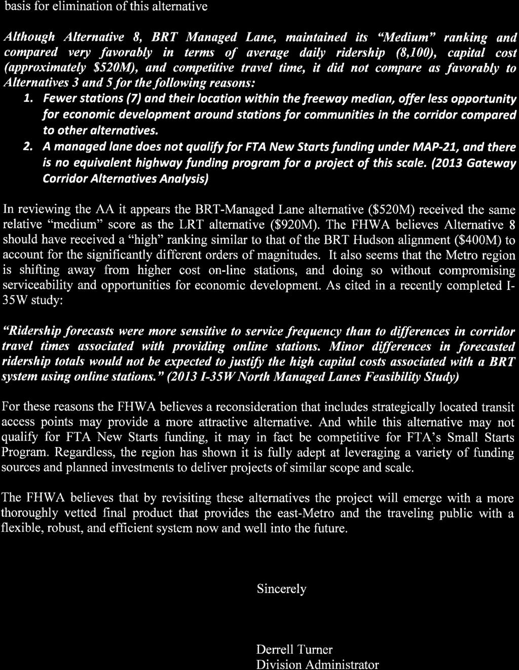
13 Managed Lane Bus Rapid Transit Alternative Technical Memo Page Draft EIS Scoping Based on the findings from the AA, a No-Build alternative, a BRT alternative, and an LRT alternative were presented in the Scoping Booklet. A BRT managed lane alternative was not included in the Scoping Booklet distributed for public comment in February 2014, but a 2009 I-94 managed lane study by MnDOT was included in the discussion of previous studies in the corridor I-94 RIGHT-OF-WAY IMPACT ANALYSIS AT THE REQUEST OF THE METROPOLITAN COUNCIL AND MNDOT In response to a request in the fall of 2013 by the Metropolitan Council and MnDOT, a technical memorandum titled I-94 Right-of-Way Impact Analysis was prepared summarizing a concept level assessment of potential impact to I-94 right-of-way and future expansion opportunities potentially resulting from the Gateway Corridor transitway. Existing right-of-way constraints in the I-94 corridor were examined in this study. Pinch points, or areas where additional right-of-way would be necessary to implement either managed lanes, a transit guideway, or both, were identified. This analysis is documented in the Gateway Corridor Technical Report: I-94 Right-of-Way Impacts (March 2014), 6 which concludes the following: 7 Analysis of existing conditions reveals that the existing corridor is already constrained in several locations. Use of outside shoulders for express bus service in addition to constrained conditions could require hauling of snow to long-term snow storage areas outside the I-94 corridor. The [Metropolitan Council s 2030 Transportation Policy Plan] identifies the segment of I-94 between downtown Saint Paul and I-694 as part of the managed lane system. However, it is not identified as either a short- or mid-term priority for construction of MnPASS lanes. MnDOT has not conducted a detailed operational analysis of this segment of I-94 to determine when a managed lane may be needed. Absent construction of a transit guideway, construction of managed lanes would require similar right-of-way and result in similar impacts to I-94 as a full dedicated guideway. Construction of both a dedicated guideway and managed lanes, should the need for both be confirmed, would require significant additional right-of-way and would likely require reconstruction of the I-94 corridor between downtown Saint Paul and I-694. In constrained areas, options have been identified for minimizing right-of-way impacts including potentially combining the guideway with frontage roads, one-way guideway lanes, reduced lane widths, one-way local street operations, and innovative snow 6 The I-94 Right-of-Way Technical Report also includes meeting summaries from the November 1, 2013 interagency coordination meeting and the November 1, 2013 right-of-way coordination meeting. 7 The 2030 TPP has been replaced by the 2040 Transportation Policy Plan, adopted in January The conclusions from this technical report are based on the information available at the time of preparation (March 2014). As presented in Section 5.6.3, in an effort to assess the ability to accommodate a dedicated BRT lane and a managed lane in the I-94 corridor, MnDOT engineers developed concept designs from Kellogg Boulevard to Maple Street, considered one the most right-of-way constrained areas of the corridor. Their effort resulted in a design that illustrates both transportation improvements could be accommodated within the corridor.
14 Managed Lane Bus Rapid Transit Alternative Technical Memo Page 11 treatment methods. These options should be further explored during concept-level design. The findings from the preliminary right-of-way analysis were presented and discussed with the TAC in November and December 2013, followed by the PAC at their December 2013 meeting FHWA REQUEST TO STUDY THE MANAGED LANE ALTERNATIVE FURTHER After the analysis of I-94 right-of-way impacts was completed, FHWA requested in a Scoping comment letter dated March 10, 2014 further study of a managed lane alternative in the Draft EIS for the following reasons: Concerns regarding the elimination of feasible alternatives that may better achieve the project purpose and need with fewer adverse impacts The need to fully inform decisions on the allocation of limited right-of-way in the corridor, particularly the accommodation of future capacity expansion and the preclusion of achieve full interstate design standards The potential degradation of interstate ramp terminal operations due to the interaction with facilities under consideration FTA, serving as the lead federal agency for the EIS, concurred with FHWA s request for additional analysis of a managed lane alternative in the Draft EIS. The FHWA letter requesting further study of a BRT managed lane alternative is included in Appendix A. Each of the items identified in the FHWA Scoping comment letter have been addressed and findings summarized in this Technical Memo. The PAC recommended and WCRRA approved the request to further evaluate a managed lane alternative RESPONSE TO FHWA REQUEST TO STUDY MANAGED LANE BRT IN THE DRAFT EIS Further coordination with FHWA, FTA, MnDOT, Metropolitan Council/Metro Transit, and Ramsey and Washington Counties was conducted to discuss the definition of the Managed Lane BRT alternative that would be evaluated in the Draft EIS. Based on meetings held on August 5, 2014 and September 5, 2014 (see meeting summaries in Appendix B), a managed lane alternative was defined (Managed Lane BRT alternative) that specifically addresses the project elements defined by FHWA, while minimizing impacts to I-94 and making the managed lane more comparable to the Dedicated BRT alternatives through the addition of stations. In this Managed Lane BRT alternative, BRT would travel within a center managed lane where feasible with inline and offline stations. 8 Details of this are discussed in Section 4. 8 Inline stations are located on the outside of the roadway. For the Managed Lane BRT alternative, that means they would be located on the outside of I-94/at freeway ramps, with BRT vehicles required to exit the managed lane to access stations. Offline stations are located outside of I-94, with BRT vehicles required to exit the managed lane and conduct several turning movements to access stations.
15 Managed Lane Bus Rapid Transit Alternative Technical Memo Page Managed Lane BRT Alternative 4.1 Managed Lane BRT Alternative Definition The following provides a description of the Managed Lane BRT alternative to be evaluated as part of the Gateway Corridor Draft EIS process. The Managed Lane BRT alternative would begin at or around the left exit off westbound I-94, providing access to 6 th Street (exit 242D on I-94) in Ramsey County, and end at Manning Avenue in Washington County, for a total length of 10.4 miles. It would include a typical section with four-foot inside shoulders, a two-foot buffer, 12-foot travel lanes, and a 10-foot outside shoulder. The additional travel lanes required would be constructed on the outside edge of the existing pavement, limiting the amount of overall roadway reconstruction required. The BRT platforms would be placed on the outside of the roadway (inline stations) to minimize the amount of roadway reconstruction required. By contrast, the managed lane concept in the AA (Optimized Alternative 8) included online stations, which are generally located in the center of the roadway. The BRT Managed Lane alternative as defined through the Draft EIS process would allow BRT to travel within the managed lane in between stations, but it would traverse the general purpose lanes near stations to access the station essentially weaving into and out of the managed lane throughout the corridor. During peak periods, or as determined necessary by Metro Transit, the bus may maintain shoulder operations between stations to avoid interaction with congestion within the general purpose lanes. In order to more easily compare across alternatives, one goal in developing the Managed Lane BRT alternative was to have a similar number of stations in similar locations as the Dedicated BRT alternatives. As such, the Managed Lane BRT alternative would have stations at the following locations (west to east): Union Depot Mounds Boulevard Earl Street Etna Street White Bear Avenue/Ruth Street McKnight Road Sun Ray Greenway Avenue The Oaks Inwood Avenue Keats Avenue Manning Avenue The Managed Lane BRT alternative is illustrated in Figure 4. More detailed concepts were prepared and are available upon request KEY PROJECTS INCLUDED IN THE NO-BUILD ALTERNATIVE Other projects currently programmed by MnDOT in the I-94 corridor have been assumed to be in place (i.e., are included in the No-Build alternative) in developing cost estimates for the Managed Lane BRT Alternative. Two of these projects are described below.
16 Managed Lane Bus Rapid Transit Alternative Technical Memo Page 13 Auxiliary Lane Project MnDOT has proposed to reconstruct I-94 eastbound between East 7 th Street and Mounds Boulevard in Saint Paul. This project includes extending an existing auxiliary lane, constructing a new auxiliary lane, constructing two emergency pull-out areas, proposing two noise barriers, reconstructing the outside shoulder, removing bus shoulder lanes, and repairing/replacement pavement. Construction is anticipated to begin in the spring of Unbonded Overlay Project MnDOT also plans to resurface 2.6 miles of I-94, extending from Mounds Boulevard to Century Avenue. In addition to concrete repair and mill and overlay, this project includes bridge repair, drainage work, guardrail replacement, and upgrading of signals, traffic system loops, and ADAcompliant features. This project is anticipated to be constructed in 2016 at the same time as the auxiliary lane project described above. 4.2 Comparison of Managed Lane BRT Alternative (Developed as part of Draft EIS Process) and Optimized Alternative 8 (from the AA) The Managed Lane BRT alternative developed for evaluation in the Draft EIS has evolved from Optimized Alternative 8 in the AA. A key difference between the AA and the Draft EIS alternatives is in operations and station types. In Optimized Alternative 8, BRT would run entirely in center managed lanes and stop at online stations; 9 with the Managed Lane BRT alternative, BRT would need to exit the center managed lane and traverse regular travel lanes in order to reach inline or offline stations on the outside edge of existing pavement. Another key difference is the number of stations. The AA assumed that Optimized Alternative 8 would end at Manning Avenue in Woodbury, stopping at seven stations along the way. The Managed Lane BRT alternative would also end at Manning Avenue in Woodbury and stop at 12 stations. A comparison of Optimized Alternative 8 and the Managed Lane BRT alternative is shown in Table 1. Optimized Alternative 8 has a slightly higher cost and slightly lower ridership compared to the Managed Lane BRT alternative. Table 1. Comparison of Optimized Alternative 8 (from the AA) and the Managed Lane BRT Alternative (developed as part of the Draft EIS process) Assumption Area Optimized Alternative 8 Managed Lane BRT Alternative Type of Station Online Inline/Offline BRT Location Center Managed Lane Center Managed Lane and Shoulder Running Eastern Terminus of Managed Lane Manning Avenue Manning Avenue Number of Stations 8 12 Ridership 8,100 8,250 Capital Cost $523M $504M Year SB I-694 to EB I-94 Flyover Included Yes ($40M) No 9 Online stations are located in the center of the roadway.

17 Managed Lane Bus Rapid Transit Alternative Technical Memo Page 14 Figure 4. Managed Lane BRT Alternative 1 1 BRT vehicles would travel within the center managed lane in between stations, but would cross through the general purpose lanes, mixing with traffic to access the stations. During peak periods, the BRT vehicle may not travel in the managed lane; instead it would operate on the right shoulder between stations to avoid congested I-94 travel lanes.
18 Managed Lane Bus Rapid Transit Alternative Technical Memo Page Analysis of the Managed Lane BRT Alternative 5.1 Capital Cost The capital costs have been prepared using the format and procedures currently required for project evaluation by FTA. The FTA methodology includes the use of standard cost categories (SCC) that group costs by various components. Also included will be soft costs or professional/technical services for items such as engineering, construction services, insurance, and owner s costs, as well as contingencies for uncertainty in both the estimating process and the scope of the project. Allocated and unallocated contingencies have been applied to compensate for unforeseen items of work, quantity fluctuations, and variances in unit costs that develop as the project progresses through the various stages of design development. Using this methodology, the Managed Lane BRT alternative is estimated to cost $503,971,000. Sitework and special conditions (SCC 40) make up approximately ¼ of the total cost. Other significant expenditures include station construction (SCC 20) and professional services (SCC 80). Contingency is included in this cost estimate. A summarized version of the cost estimate is shown in Table 2. Table 2. Managed Lane BRT Alternative Cost Estimate SCC Code Description Total Costs 10 Guideway and Track Elements $9,510, Stations, Stops, Terminals, Intermodal $80,090, Support Facilities: Yards, Shops, Administrative Buildings $11,960, Sitework and Special Conditions $138,480, Systems $52,400, Right-of-Way, Land, Existing Improvements $22,530, Vehicles $18,000, Professional Services $87,740, Unallocated Contingency $83,260,000 TOTAL $503,970, Ridership Forecast 2040 ridership forecasts for the Managed Lane BRT alternative are summarized in Table 3. Table Ridership Forecast for the Managed Lane BRT Alternative Daily Ridership Saint Paul Express Routes (Off-Guideway) 1,270 Minneapolis Express Routes 3,090 Station to Station (BRT) 8,250 Guideway Express/Limited Stop 780 Corridor Total 13,390
19 Managed Lane Bus Rapid Transit Alternative Technical Memo Page Travel Time Travel time for the Managed Lane BRT alternative was calculated for both the eastbound and westbound directions using the following assumptions: Traffic signal delay, station dwell times, and BRT vehicle acceleration/deceleration rates would be the same as for the Dedicated BRT alternatives In some segments of I-94 the BRT vehicles could attain 55 mph; however, travel time was calculated using 45 mph due to possible future congestion and weaving issues Where the speed limit is 65 mph on I-94, BRT vehicles were assumed to travel at 55 mph for consistency and safety Distances between stations were measured using the farthest right general purpose lane or shoulder lane when stations would be too close together for the vehicle to use the managed lane In the eastbound direction, travel time for the Managed Lane BRT alternative would be approximately 34 minutes. In the westbound direction, travel time would be approximately 32 minutes. 5.4 Congested Related Findings A travel time reliability analysis was conducted on I-94 from I-35E on the west to Manning Avenue on the east to identify where congestion is occurring in the corridor and the frequency and severity of congestion where it is present. The highest congestion segment is found in the westbound direction of I-94 between McKnight Road and I-35E. In this area, commuters experience travel times over twice of what they would if they were traveling at free-flow speed. Speeds are expected to be reduced to less than 30 mph every other day, on average, when the posted speed limit sign is 55 mph. Additionally, vehicle speeds are expected to drop below 20 mph once a week. This is an indication that this stretch of I-94 is unreliable for westbound travelers during the a.m. peak period under current conditions. 10 Since most of the observed congestion is recurring and has similar duration and extent from day to day, buses can achieve time savings compared to general purpose traffic by using busonly shoulders. This savings is modest, however, as typical congested speeds are just under 30 mph and the maximum bus shoulder speed is 35 mph Operational Considerations In the Managed Lane BRT alternative, BRT would travel within the managed lane in between stations, but it would traverse the general purpose lanes near stations to access the station essentially weaving into and out of the managed lane throughout the corridor. During peak periods, or as determined necessary by Metro Transit, the bus may maintain shoulder operations between stations to avoid interaction with congestion within the general purpose lanes. Metro Transit reviewed this alternative from an operating perspective and concluded that in this case, it does not maximize transit operations, travel, or development potential. Metro 10 Gateway Corridor Managed Lane/Freeway Performance Analysis (SRF Consulting Group, 2014) 11 Minnesota Statutes, section
20 Managed Lane Bus Rapid Transit Alternative Technical Memo Page 17 Transit noted that the Managed Lane BRT alternative has some similarities to Highway BRT as defined in the Regional Transitway Guidelines, 12 but it deviates from Highway BRT design and operations guidance in several significant ways. While it is recognized that managed lanes and BRT operating in freeway lanes can be an efficient and cost-effective transitway investment in the Twin Cities Metropolitan Area, the Managed Lane BRT alternative does not effectively meet the Gateway Corridor s (METRO Gold Line) purpose and need (see Section for additional discussion). Key elements of the Managed Lane BRT alternative as designed are problematic for customers, the transit operator (Metro Transit), and future development, with these difference from a Highway BRT type of service: Station placement and design stations are split by direction and separated by I-94 in many cases This limits customer access by increasing walk/bike distance and infrastructure This does not provide anchor locations for intensification of local land development and for future transit markets Three stations are not conveniently located for existing or future transit markets A fourth station is proposed off the runningway where it would yield significantly higher operating costs and passenger delays due to travel distance and presence of several traffic signals Station spacing and runningway 5.6 Right-of-Way Close station spacing combined with inline station locations adjacent to shoulders does not allow use of the center managed lane. Using the center managed lane would require buses to weave across several lanes of traffic between stations, negating the benefit of using them. This would then be operated on a Bus Only shoulder with lower speeds, minimizing the benefit and attractiveness of transit. As a result, a consistent and reliable runningway for buses that minimizes conflict with general traffic does not functionally exist EXISTING CONDITIONS Existing I-94 right-of-way from Kellogg Boulevard to I-694 is described below. From I-694 to Manning Avenue, right-of-way impacts are limited to private property associated with proposed inline stations. Hence, the eastern point for the existing condition description is I-694. Kellogg Boulevard to Maria Avenue/Wilson Avenue Intersection (Segment Adjacent to I-94 Kellogg Boulevard Exit Ramp) The distance from MnDOT right-of-way to ramp pavement edge varies from approximately 70 feet to less than 10 feet. The right-of-way line through the segment is irregular and follows parcel boundary lines of adjacent properties. 12
21 Managed Lane Bus Rapid Transit Alternative Technical Memo Page 18 Maria Avenue/Wilson Avenue Intersection to Maple Street (Segment Adjacent to I-94 Mainline) Throughout this segment the MnDOT right-of-way line sits either exactly at or up to 5 feet north of the north edge of I-94 pavement. Approximately 200 feet west of Maple Street, the right-of-way line begins to shift slightly northward to a distance of 15 to 20 feet at Maple Street. Maple Street to Johnson Parkway (Segment Adjacent to I-94 Mainline) The distance of the MnDOT right-of-way line from edge of pavement lies 20 feet north of edge of pavement at Maple Street to 60 feet at the mid-point (Earl Street) to 20 feet again just west of Johnson Parkway. Vertical separation between I-94 and Hudson Road also varies through this segment from nearly level at Maple Street to a 20 to 25 foot vertical separation (overpass over I-94) at Earl Street to nearly level approximately 400 feet east of Earl Street, to a 7 foot vertical separation in the opposite direction as Hudson Road diverges away from I-94 near Johnson Parkway (I-94 over Johnson Parkway). Johnson Parkway to Hazelwood Street (TH 61 Interchange Area) The distance between pavement edge to the MnDOT right-of-way continues at approximately 20 to 30 feet east of Johnson Parkway to the property at 1276 Wilson Avenue. The proximity of the southeast corner of this building with the existing MnDOT noise wall/edge of pavement represents one of the most constrained points in the Gateway Corridor with 18 feet between the property line and edge of roadway. Continuing east, the MnDOT right-of-way boundary expands northward in a stepped fashion consistent with adjacent parcel boundaries to accommodate the TH 61 interchange ramps. Beginning at Clarence Street and extending east past Etna Street to beyond Birmingham Street, the MnDOT right-of-way line lies approximately 1,000 feet north of the I-94 edge of pavement. Continuing east beyond the interchange area, the right-of-way line steps south until it sits immediately proximate to the edge of I-94 pavement at the pedestrian bridge. Hazelwood Street to Ruth Street (White Bear Avenue Interchange Area) From the pedestrian bridge at Hazelwood Street east to the merge point of the westbound White Bear Avenue on-ramp, the MnDOT right-of-way line lies approximately 10 feet away from the edge of shoulder. At the merge point, the right-of-way steps 50 feet northward and parallels the ramp pavement edge at a distance of approximately 60 feet to White Bear Avenue. The right-of-way boundary parallels the mainline at a distance of approximately 130 feet to Hazel Street, where it steps northward and runs along the south edge of Hudson Road to Ruth Street. Ruth Street to McKnight Road (Sun Ray Shopping Center Area) With the exception of the interchange ramp locations at either end of this segment, the MnDOT right-of-way boundary lies about 20 feet north of edge of mainline pavement. At Ruth Street, the right-of-way parallels the south edge of Hudson Road; at McKnight Road, it lies approximately 20 to 30 feet north of Hudson Road. McKnight Road to Century Avenue (3M Corporate Campus Area) The MnDOT right-of-way line sits approximately feet north of the I-94 mainline for the majority of this segment, with the right-of-way line moving northward as it approaches Century Avenue to accommodate the Century Avenue interchange ramps. Hudson Road lies within MnDOT right-of-way in this segment.
22 Managed Lane Bus Rapid Transit Alternative Technical Memo Page 19 Century Avenue to I-694 Crossing The MnDOT right-of-way line lies approximately 120 feet north of I-94 to a point east of Hadley Avenue, then continues to parallel the southbound I-694 to westbound I-94 ramp at a similar distance. In the west portions of this segment, the right-of-way line extends through Tanners Lake and the parking areas of several businesses located on Hudson Road. Hudson Road is constructed within MnDOT right-of-way in this portion of the segment until it turns north just west of the I-694 interchange and becomes Hadley Avenue SUMMARY OF IMPACTS Given the constrained right-of-way of the I-94 corridor, public and private right-of-way would need to be acquired to accommodate the Managed Lane BRT alternative, most notably in the section from Kellogg Boulevard to White Bear Avenue, in Oakdale/Landfall near Tanners Lake, and at the interchange of I-94 and I-694. The proposed inline stations at Sun Ray, 3M, Greenway Avenue, and Helmo Avenue would also have impacts to private property RIGHT-OF-WAY ANALYSIS CONDUCTED TO DETERMINE FEASIBILITY OF FUTURE EXPANSION OPPORTUNITY IN THE I-94 CORRIDOR FROM MOUNDS BOULEVARD TO TH 61 In an effort to assess the ability to accommodate Dedicated BRT and managed lanes from Mounds Boulevard to Trunk Highway (TH) 61 in the I-94 corridor, MnDOT engineers developed concept designs from Kellogg Boulevard to Maple Street, considered one the most right-of-way constrained areas of the corridor. Their effort resulted in a design that illustrates both transportation improvements could be accommodated in this right of way constrained area of I-94. This particular effort, while independent of the Gateway Corridor Draft EIS evaluation, addresses the comment provided by FHWA in their Scoping comment letter (March, 2014): The need to fully inform decisions on the allocation of limited right of way in the corridor; particularly the accommodation of future capacity expansion and the preclusion of achieving full Interstate design standards. The memorandum prepared by the Metropolitan Council, MnDOT, and the Gateway Corridor Commission outlines the process, the findings, and the conclusions specific to the Gateway Gold Line Dedicated BRT and Managed Lane Shared Concept (see Appendix A). 5.7 Preliminary Social, Economic, Environmental Evaluation ALTERNATIVES ANALYSIS As part of the Alternatives Analysis process and documentation, environmental and community impact assessment was conducted on the AA Managed Lane alternative with consideration of National Environmental Policy Act (NEPA) requirements. Topics considered during the AA level impact assessment included: Air quality (change in regional classification) Noise and vibration Water features, including: floodplains, wetlands, lakes, streams, and rivers Parks and other public lands Potential community effects, such as: Service to population and employment centers Service to low-income households Environmental justice
23 Managed Lane Bus Rapid Transit Alternative Technical Memo Page 20 The environmental review for this AA relied on existing information to provide a screening level assessment of environmental issues using a GIS analysis. This information was supplemented with discussions with agency, city, and county staff; public input; as well as through high level field investigations as needed to identify potential issues. The Environmental and Community Impact Assessment Methodology and Results Report (August 2012) 13 summarizes the findings from the AA DRAFT EIS The findings from the AA analysis were referenced during the evaluation of the Managed Lane BRT alternative, as applicable. A detailed social, economic, and environmental (SEE) evaluation has not been conducted for the Managed Lane BRT alternative, as resources have been focused on the definition of the alternative to effectively address the request by FHWA, the characteristics of the alternative (cost, ridership, travel time), operational and safety considerations of the alternative, and the ability of the alternative to effectively meet the project goals and objectives. During the preliminary evaluation of the Managed Lane BRT alternative, several areas of the SEE analysis, in addition to right-of-way, have been qualitatively considered and discussed: environmental justice, accessibility, economic development, noise, and stormwater. The environmental justice and accessibility assessment has focused around the accessibility of the stations, primarily in St. Paul and Landfall areas. Under the Managed Lane Alternative, the in-line stations on the shoulders and on I-94 ramps limit customer access by increasing walk/bike distance and infrastructure, as the stations are split by direction and separated by I- 94 in most locations. The economic development assessment has focused on the ability of the proposed station locations to accommodate future transit oriented development potential (TOD). The initial analysis indicates that in-line stations do not provide an environment or space for TOD. The noise assessment has focused on the type of noise analysis that would be required under the Managed Lane BRT alternative. Specifically, the Managed Lane BRT alternative would fall under the definition of a Type I project, which would require noise analysis in compliance with FHWA regulations. Currently, the noise analysis for the Gateway Corridor is being conducted under the FTA Noise Guidance and state requirements. The stormwater assessment has focused on additional stormwater requirements associated with increasing the impervious area of the I-94 corridor, and the limited right-of-way available to effectively mitigate potential impacts. While not specific to the proposed Managed Lane BRT alternative, one of the issue areas raised in the FHWA Scoping comment letter (March 2014) was the concern regarding potential degradation of Interstate ramp terminal operations due to the interaction with the facilities under construction. As part of the traffic analysis completed for the proposed Dedicated BRT alternatives, interstate ramp terminal operational analysis was completed. A summary of those findings is presented below. Off-Ramp to Kellogg Boulevard: The queuing along Mounds Boulevard was reviewed to confirm that it does not impact the interstate ramp terminal operations. Based on the analysis, the maximum distance that vehicles are anticipated to back up to is 630 feet (during the AM peak hour). The existing distance from Kellogg Boulevard to the off-ramp 13 Available at
24 Managed Lane Bus Rapid Transit Alternative Technical Memo Page 21 from I-94 WB is +/- 360 feet and an additional +/- 1,740 feet to the gore (where the ramp meets the interstate). Therefore, the anticipated queue along Mounds Boulevard for 2040 Build conditions is not anticipated to impact the interstate ramp terminal operations. Off-Ramp to McKnight Road: The queuing along Hudson Road was reviewed to confirm that it does not impact the interstate ramp terminal operations. Based on the analysis, the maximum distance that vehicles are anticipated to back up to is 676 feet (during the PM peak hour). The existing distance from McKnight Road to the off-ramp from I-94 westbound is +/- 3,370 feet and an additional +/- 1,030 feet to the gore (where the ramp meets the interstate). Therefore, the anticipated queue along Hudson Road for 2040 Build conditions is not anticipated to impact the interstate ramp terminal operations. Off-Ramp to Keats Avenue: The queuing along the I-94 WB off-ramp to Keats Avenue was reviewed to ensure that it does not impact the interstate ramp terminal operations. Based on the analysis, the maximum distance that vehicles are anticipated to back up to is 215 feet (during the AM peak hour, assuming dual WB right-turn lanes). The existing distance from Keats Avenue to the gore area (where the ramp meets the interstate) is +/- 1,820 feet. Therefore, the anticipated queue along the I-94 WB off-ramp to Keats Avenue for 2040 Build conditions is not anticipated to impact the interstate ramp terminal operations. 6.0 Coordination Activities During and After Scoping Period Since FHWA submitted their Scoping comment letter in March 2014, three coordination meetings have occurred. Meeting summaries are provided in Appendix B. 6.1 August 5, 2014 Meeting The purpose of this meeting was to discuss the managed lane alternative proposed by FHWA, define the overall concept of the alternative, and discuss the approach to evaluating the alternative. The group, consisting of representatives from Washington County, Ramsey County, the Metropolitan Council, MnDOT, FHWA, and the Gateway Corridor consultant team, determined that the managed lane would start at the left exit off of westbound I-94, providing access to 6 th Street (exit 242D), and end at Manning Avenue. Based on previous direction from FHWA, the managed lane would include a typical section of four-foot inside shoulders, a two-foot buffer, 12-foot travel lanes, and a 10-foot right shoulder. Additional travel lanes would be added to the outside of the existing pavement to minimize reconstruction of the entire roadway. Bridge reconstruction to accommodate the wider crosssection would need to be evaluated as part of the concept design work. The intent of the design concept is to have inline stations to minimize the amount of roadway reconstruction required. FHWA did indicate that online stations are not precluded from the concept if the design team feels they are appropriate at specific locations. This concept would allow BRT to potentially travel within the managed lane between stations, but it would traverse the general purpose lanes near stations to access the station essentially weaving into and out of the managed lane throughout the corridor.
25 Managed Lane Bus Rapid Transit Alternative Technical Memo Page 22 The Gateway project team was directed to further develop the managed lane concept as part of the Draft EIS process. The following items were identified as information needs: Additional information on right-of-way impacts Impacts to existing shoulder widths Updated capital cost estimates Ridership modeling Traffic modeling 6.2 September 5, 2014 Meeting Representatives from the Gateway Corridor consultant team, Washington County, Ramsey County, FHWA, MnDOT, the Metropolitan Council, and FTA participated in this meeting. The proposed managed lane definition that was developed at the August 5, 2014 meeting was reviewed, and aerial maps were used to review the alternative. Areas where the existing roadway would be expanded to accommodate a managed lane were marked on the aerial maps. Some general review points included: Bridge reconstruction would potentially be needed at Mounds Boulevard, Earl Street, and Ruth Street Bridge widening would be needed at Century Avenue A station was added at Etna Street to be more consistent with the other alternatives under consideration, but pedestrian access would be very challenging Buses would access the White Bear Avenue station via the on/off diamond ramps A park-and-ride was assumed at Sun Ray Existing ramps would be utilized to access the 3M Campus area, and a pedestrian overpass would be provided to connect to the eastbound and westbound stations There would be offline stations at Radio Drive, Keats Avenue, and Manning Avenue An evaluation approach memo was provided to participants. Specific comments on the evaluation approach can be found in the meeting summary in Appendix B. 6.3 June 9, 2015 Meeting Representatives from FHWA, MnDOT, Washington County, Ramsey County, Metro Transit, the Metropolitan Council, and the Gateway Corridor consultant team participated in this meeting. A review was provided of the managed lane discussions in the AA and Scoping processes, and the August 5, 2014 and September 5, 2014 meetings were summarized. The definition of the managed lane alternative for evaluation in the Draft EIS was referred to in this meeting as the Optimized Managed Lane. 14 This Optimized Managed Lane alternative was reviewed, and the following key points were provided: The optimized concept includes inline stations Stations were added at Mounds Boulevard, Etna Street, Sun Ray, Greenway Avenue, and The Oaks Offline stations were proposed at Radio Drive, Keats Avenue, and Manning Avenue 14 In the Draft EIS document, this alternative will be referred to as the Managed Lane BRT alternative, as defined in Section 4.1.
26 Managed Lane Bus Rapid Transit Alternative Technical Memo Page 23 The Optimized BRT alternative would terminate on the east at Manning Avenue Findings on cost, ridership/travel time, and congestion-related considerations from the preliminary Optimized Managed Lane analysis were reviewed along with comments from Metro Transit on operations. The participants discussed how the Optimized Managed Lane concept should be treated in the Draft EIS. Consensus was reached by the group to package the findings of the analysis in a memo and reconvene the working group to confirm next steps relative to the Draft EIS. At a minimum, the Optimized Managed Lane alternative will be included in the Draft EIS chapter on alternatives (Chapter 2). Following preparation of the referenced memo, additional conversation will be required with FTA and FHWA regarding the level of detail in the Draft EIS. 7.0 Summary of Other Project Activities in the Gateway Corridor In addition to the programmed projects in the Gateway Corridor, there is a planned Downtown Minneapolis to Downtown Saint Paul Engineering Effort that will be initiated by MnDOT. MnDOT will develop a set of improvements that may include implementation of a MnPASS lane to reduce congestion, preserve existing assets, and enhance safety in the corridor. 8.0 Alternative Evaluation 8.1 Does the Alternative Meet the Purpose and Need for Gateway? BACKGROUND The purpose of the Gateway Corridor project is to provide transit service to meet the existing and long-term regional mobility and local accessibility needs for businesses and the traveling public within the project area. The following primary factors contribute to the need for the Gateway Corridor project: Limited existing transit service throughout the day and demand for more frequent service over a larger portion of the day Policy shift toward travel choices and multimodal investments Population and employment growth, increasing access needs and travel demand Needs of people who depend on transit Local and regional objectives for growth and prosperity The following goals have been developed to serve as a framework to evaluate the alternatives under consideration for the Gateway Corridor. Goals 1 and 2 (Tier 1 goals) identify the minimum requirements that an alternative would be expected to meet to advance. Goal 1: Improve Mobility Goal 2: Provide a Cost-Effective, Economically Viable Transit Option Goals 3-5 (Tier 2) reflect broader community goals and may be helpful in comparing alternatives that meet the Tier 1 goals. Goal 3: Support Economic Development Goal 4: Protect the Natural Environmental Features of the Corridor Goal 5: Preserve and Protect Individual and Community Quality of Life
27 Managed Lane Bus Rapid Transit Alternative Technical Memo Page EVALUATION While it is recognized that managed lanes and BRT operating in freeway lanes can be an efficient and cost-effective transitway investment in the Twin Cities Metropolitan Area, the Managed Lane BRT alternative does not effectively meet the Gateway Corridor s (METRO Gold Line) purpose and need based on the following: Station Accessibility (Goal 1): Proposed stations for the Managed Lane BRT alternative have been located at similar locations as the Dedicated BRT alternatives, while reflecting either inline (stations adjacent to shoulders or ramps) or offline design to minimize cost and impact (compared to online stations proposed during the AA phase of analysis). Given that the stations are split by direction and separated by I-94 in many cases, this results in reduced levels of accessibility as transit patrons are required to increase their walk/bike distance, along with the requirement to provide additional infrastructure such as pedestrian crossings at the Etna Street, Sun Ray, 3M Headquarters, Greenway Avenue, and Helmo Avenue Stations. Additionally, the inline stations do not provide for effective local bus connections. Transit Mobility and Operations (Goals 1 and 2): The proposed station spacing, combined with inline station locations adjacent to shoulders, does not allow for use of the center managed lane. Using the center managed lane would require buses to weave across several lanes of traffic between stations, negating the benefit of using the managed lane. The alternative would then be operated as a Bus Only Shoulder with lower speeds, which minimizes the benefit to and attractiveness of transit. As a result, a consistent and reliable runningway for buses that minimizes conflict with general traffic does not functionally exist. Additionally, assuming the buses would operate in Bus Only Shoulders throughout the corridor to avoid the weaving from station to station, travel time benefits for transit would be limited given assumed travel speeds. Cost-Effectiveness (Goal 2): The offline stations (Guardian Angels, Keats Avenue, and Manning Avenue) are proposed off the runningway, resulting in higher operating costs and passenger delays due to travel distance and presence of several traffic signals. Additionally, the Managed Lane BRT alternative would not meet the FTA s definition of a New Starts project, and hence would not be eligible for New Starts funding. An alternative funding source, which is not available at this time in the region, would be required for the Managed Lane BRT alternative to advance. Support Economic Development (Goal 3 (Tier 2 Goal)): The proposed inline and offline stations do not provide anchor locations for the intensification of local land development. The assessment provided above addresses FHWA s Scoping comment: The elimination of feasible alternatives that may better achieve the project s purpose and need with fewer adverse impacts. 8.2 Approach to Addressing in the Draft EIS Based on the information presented in this technical memorandum relative to the Managed Lane BRT alternative s ability to effectively meet the purpose, goals, and objectives of the
28 Managed Lane Bus Rapid Transit Alternative Technical Memo Page 25 Gateway Corridor, it is recommended that this alternative be presented in the Draft EIS in Chapter 2 Alternatives and then screened from detailed analysis in the remaining chapters of the document. This technical memorandum will serve as additional documentation as part of the project record, complying with FHWA s request to fully inform decisions on the allocation of limited right-of-way in the corridor. The project will continue to work with all partners to coordinate the operational and expansion needs of I-94.
29 Managed Lane Bus Rapid Transit Alternative Technical Memo Appendix A Correspondence

30
31
32

33 MEMORANDUM Date: September 24, 2015 To: Congresswoman Betty McCollum Metropolitan Council Member Harry Melander Metropolitan Council Member Jon Commers Ramsey County Commissioner Jim McDonough Mayor Mary Giuliani Stephens From: Metropolitan Council Chair Adam Duininck Gateway Corridor Commission Chair Lisa Weik Gateway Corridor Commission Co-Chair Rafael Ortega MnDOT Commissioner Charlie Zelle Re: Gateway Gold Line Dedicated Guideway BRT and Managed Lane Shared Concept This memo is a follow-up to the Gateway Corridor meeting on Friday, August 10, 2015 held at the Metropolitan Council. We are pleased to report a positive outcome to the challenge of accommodating both BRT and managed lanes just east of downtown St. Paul. This memo provides information about a Gateway Corridor Dedicated Guideway BRT and Managed Lane shared concept developed by MnDOT with guidance, input, and participation from the Metropolitan Council, FHWA and the Gateway Corridor project team. Background: The Gateway Gold Line BRT is a proposed bus rapid transit line that would run next to Interstate 94 for 12 miles in an exclusive lane on Hudson Road between the Union Depot in downtown Saint Paul and Woodbury/Lake Elmo. All-day transit service would stop at 13 stations and include connections to the growing regional transit system. The system could open for service by The project is currently preparing a Draft Environmental Impact Statement (DEIS). One of the key issue areas identified during the evaluation of alternatives pertains to available public right-of-way (ROW) in the I-94 Corridor. While the Gateway Corridor Draft EIS evaluates
34 the potential ROW impacts, both public and private, associated with Dedicated BRT; policy makers were keenly interested in understanding how a future transportation improvement, such as a Managed Lane planned for in the 2040 Transportation Policy Plan could be accommodated from Mounds Park Boulevard to Trunk Highway 61. MnDOT, FHWA, Metropolitan Council, Metro Transit, Washington and Ramsey County staff collaborated over the past few months to address this important issue. The most constrained area of the corridor was identified to be from Mounds Boulevard to Maple Street, and hence was the focus of the design effort. Solution: Through the expertise of MnDOT staff, while consulting with the other project partners, a shared concept was designed. This shared concept demonstrates that the Gateway Gold Line BRT and a managed lane can fit within the assumed right-of-way constraints. A technical narrative with concept drawing is attached. The shared concept design includes the follow general features: Gateway Gold Line BRT lanes designed at 13-feet wide provide for safe transit operations; It is assumed that the preservation of the existing sound wall (and any new pieces to be constructed before Gateway) can likely be preserved in its approximate location, with minimal changes or alterations, and would be placed in a position that would aid in safety, snow removal, and noise reduction; and Approximately 75% of the pavement on Interstate 94 would be saved because the managed lane design mostly shifts striping and does not necessitate a full re-build of the freeway. In summary, the Metropolitan Council, MnDOT, and Ramsey and Washington Counties staff are confident that the Gateway Gold Line BRT can be built along with a managed lane from downtown Saint Paul to Highway 61 with few competing impacts to either project. Framework for Future Collaboration: This product is a result of multi-agency collaboration that will serve as a model for future policy and technical challenges as the Gateway Gold Line BRT advances in the design process. Critical to this collaboration was a multi-agency work group that was formed to address this specific right-of-way issue, the open brainstorming of technical and policy solutions, and documented support for the shared solution. Attachment: Technical Narrative and Concept Drawing dated September 22, 2015
35 Gateway Bus Rapid Transit and MnPASS Technical Narrative September 22, 2015 The proposed MnPASS facility could be developed within the constraints of the proposed Gateway BRT Guideway and the I-94 right-of-way without the acquisition of any more additional right-of-way than what is proposed with Gateway. The proposed plan provides for the preservation of the sound wall along Old Hudson Road, in roughly its current location. This not only provides the opportunity to preserve most of the existing sound wall, but, also provides positive and safer separation between the Gateway BRT facility and I-94. The plan highlights the design efficiency of the guideway to preserve travel lane widths vs. additional curb and gutter, while providing for adequate storm water drainage. The plan preserves the walkability of the residential and commercial districts in this area through improved sidewalk and pedestrian facilities. The reconfigured BRT guideway provides enough room to preserve adequate lane widths along I-94, while providing for a center-oriented MnPASS facility at some time in the future. Lastly, the revised MnPASS plan holds to the north curb lines of I-94, thus, preserving approximately 75% of the unbonded concrete overlay work currently under development.

36 Gateway Bus Rapid Transit and MnPASS Concept Drawing September 22, 2015

37 Managed Lane Bus Rapid Transit Alternative Technical Memo Appendix B Meeting Summaries
38 Managed Lane Alternative Meeting Summary Tuesday, August 5, :00 4:00 pm Kimley-Horn and Associates Attendees: Andy Gitzlaff, Washington County Kevin Roggenbuck, Ramsey County Steve Elmer, Metropolitan Council Amy Vennewitz, Metropolitan Council Bill Goff, MnDOT Brian Isaacson, MnDOT Nnaemeka Ezekwemba, FHWA Andrew Emanuele, FHWA Lisa Rasmussen, Kimley-Horn Jim Gersema, SRF 1. The purpose of the meeting was to discuss the managed lane alternative proposed by FHWA, define the overall concept of the alternative, and discuss the approach to evaluating the alternative, including identification of the level if information that FHWA would like to see. 2. FHWA (Nnaemeka Ezekwemba) provided previous direction for the managed lane alternative via an sent to Andy Gitzlaff on July 16 th (attached), which was restated as part of this meeting: a. Include refinements on the west end of the project that incorporate service connections to the Union Depot Station and the planned I-94 managed lane system. Also, consider local transit improvements for the residents in the vicinity of Mounds Boulevard. In addition to improvements tied to this project, a similar approach to the dismissal of alignment B2 and the planned arterial BRT for East 7 th Street seems acceptable to capture additional riders. b. Consider the incorporation of more park and rides, inline transit stations, narrower transit-ramps, or a combination to further improve ridership while reducing costs and impacts c. Minimize reconstruction by removing the assumed center transit station, minimize median reconstruction, and apply a typical section of 4ft inside shoulders, 2ft buffer, 12ft travel lanes, and a 10ft right shoulder to accommodate bus on shoulder use throughout the corridor d. Break out daily ridership into with express and without express riders criteria as applied to the BRT transitway Discussion as part of this meeting focused on items b and c above. 3. Lisa Rasmussen and Jim Gersema provided an overview of the previous work that has been completed the I-94 Right-of-Way Impacts analysis completed in March 2014 and the Managed Lane Alternative memo submitted to FTA in May This overview included a review of the existing right-of-way pinchpoints in the corridor identifying that there are three general pinchpoint locations in the corridor today, between Mounds Blvd and TH 61, west of
39 Page 2 White Bear and adjacent to Tanners Lake. This evaluation considered existing conditions, a managed lane alternative only (BRT/BRT stations were not included as part of the evaluation), dedicated guideway (located on the north side of the freeway) and a managed lane + dedicated guideway alternative. 4. BRT operations in the corridor was clarified to be an all-day service with either 15-minute or 30- minute service, depending on the time of day. Express service would remain during peakperiods. 5. The discussion then proceeded into defining the managed lane alternative. a. Where does managed lane start? The group discussed the how the managed lane would provide access into DT St. Paul and where the managed lane would end as part of the Gateway project. It was determined that the managed lane, as defined for the Gateway project, would end at the left exit off of I-94 WB, providing access to 6 th Street (exit 242D). The group also discussed the managed/mnpass study that is currently underway for the portion of I-94 between Minneapolis and St. Paul. That study is identifying that the MnPASS lanes would end at Marion Street, creating a gap between the two managed lane/mnpass projects. It was recognized that this is something to be considered in the future, but not something that should be included as part of the Gateway project. This analysis needs to be completed, but is not currently planned to be included as part of the Gateway project. The outcome of this study will help determine the position FHWA and MnDOT take on R/W protection in the Gateway Corridor and will need to be done in a timely manner. Nnaemeka requested that the Gateway project team review the ability to perform a sensitivity test on whether or not filling the MnPASS gap would result in any additional riders for the Gateway project. It was discussed that this would likely only have an increase on Minneapolis-bound express riders. The Gateway team to review the feasibility of this sensitivity test. b. What does the managed lane alternative look like? As described in item 1c above, the managed lane would include a typical section of 4-ft inside shoulders, 2-ft buffer, 12-ft travel lanes, and a 10-ft right shoulder. Additional travel lanes would be added to the outside of the existing pavement, minimizing reconstruction of the entire roadway. Bridge reconstruction to accommodate the wider cross-section will need to be evaluated as part of the concept design work. The intent of the design concept is to place the BRT platforms on the outside of the roadway (inline stations), to minimize the amount of roadway reconstruction required. Online stations (within the center of the roadway), as included within the AA concept, would require significant amount of roadway reconstruction, shifting the lanes on both sides of the roadway to accommodate the platform. FHWA did indicate that Online
40 Page 3 Stations are not precluded from the concept if the design team feels that they are appropriate at specific locations. This concept would allow BRT to potentially travel within the managed lane in between stations, but would traverse the general purposes lanes near stations to access the station essentially weaving into and out-off the managed lane throughout the corridor. It was agreed that weaving would be easier to do at different times of the day; during the peak period, the bus may spend more time within the roadway shoulder to maintain headways/travel time. Existing general purpose lanes, as currently configured today cannot be removed from the overall I-94 cross-section as part of this alternative. i.e., the two WB auxiliary lanes between TH 61 and Mounds Blvd cannot be reduced down to one lane. Other auxiliary lanes may be able to be converted to general purpose lanes, as evaluated on a case by case basis. Existing jointing of the concrete pavement does not need to be factored into the managed lane concept. Specific to the I-94/I-694 interchange, it was discussed that the interchange may need some improvements to accommodate the managed lane (bridge abutment modifications), but the flyover concept that was included as part of the AA may not be required. The Gateway project team to further develop the managed lane concept as part of the Draft EIS process. c. Where does the managed lane end? The managed lane alternative was identified to end at Manning Avenue. The meeting included some group discussion on whether or not it should end prior to I-694, but it was ultimately determined to end at Manning Avenue in order to maintain consistency between the alternatives. The Gateway project team to evaluate the best BRT routing for the portion of the corridor east of I-494/I-694. d. What information is FHWA looking for? Items identified below are for the managed lane and LPA alternatives. o Additional information on R/W impacts o Impacts to existing shoulder widths o Updated capital cost estimates (level of detail TBD) o Ridership modeling (level of detail TBD) o Traffic modeling Specific to the LPA, FHWA requested that a microanalysis of the interchanges that are affected by the guideway, be completed to confirm if there is any impact to the queuing on the interchange ramps. The Gateway project team to identify a proposed approach for this request.
41 Page 4 Specific to the managed lane alternative, Met Council to provide any needed traffic modeling. 6. Next steps identified as part of the meeting included: a. Coordinate a follow-up meeting around August 21 st. Meeting would review the managed lane alternative as well as the LPA design development. b. The Gateway project team to develop an approach/methodology document for managed lane alternative to be circulated among the meeting attendees; confirming that the approach is acceptable. c. Follow-up on the action items (bold) identified above.
 Adam Stephenson, FTA (via")
42 Draft Environmental Impact Statement Page 1 FHWA Meeting Summary SEPTEMBER 5, 2014 Attendees Jim Gersema, SRF Lisa Rasmussen, Kimley-Horn Jeanne Witzig, Kimley-Horn Steve Wilson, SRF Andy Gitzlaff, WCRRA Kevin Roggenbuck, RCRRA Emeka Ezekwemba, FHWA Jim McCarthy, FHWA Jim Henricksen, MnDOT Bill Goff, MnDOT Steve Elmer, Metropolitan Council Chris Bertch, FTA (via phone) Adam Stephenson, FTA (via Phone) Ben Owen, FTA (via phone) Summary Overall review of proposed managed lane definition that was discussed in previous meeting, key used in developing the concepts. Primary premise was to provide inline stations (adjacent to the shoulder or on the on/off ramps) and buses would traverse from the managed lane to the shoulder to access the stations. Proposed station spacing may not allow buses to travel in the managed lane as much as originally discussed. During the meeting it was clarified that the managed lane is not on a super shoulder, which was reviewed roughly a year ago, in response to a previous Met Council/MnDOT request. Aerial maps were used to review the alternative yellow lines on the map identify where the existing roadway would be expanded to accommodate a managed lane. General Review Points (West to East) 1. Mounds Boulevard bridge likely reconstructed to accommodate managed lane 2. Reconstruct bridge at Earl Street 3. Etna station was not part of original AA definition, added to be more consistent with BRT stations. It was discussed that pedestrian access to this station is very challenging design team to review feasibility and need for this station. 4. White Bear buses would utilize on/off diamond ramps to access station located at White Bear Avenue. 5. Ruth potential bridge reconstruction to accommodate the managed lane 6. Sun Ray It is assumed that, similar to the LPA, a park-and-ride would be provided at this station 7. 3M Campus Area (McKnight to Century Ave) BRT would utilize existing access ramps (WB) to access station at 3M, utilizing the frontage road to also access the Sunray Station. Pedestrian overpass would be provided to connect WB and EB stations. 8. Century Avenue existing bridge widening to accommodate the managed lane interchange design team to verify the bridge reconstruction/modifications required to accommodate a managed lane East of 694 Existing space available to construction the managed lane within the existing median
43 Draft Environmental Impact Statement Page Radio Drive off line station access 11. Keats area off line station 12. Manning off line station 13. Managed Lane in outside - NO, per original meeting direction. Evaluation Approach Memo Walked through evaluation approach memo that was provided to participants. Specific Comments from Participants Jim McCarthy Proposed managed lane design works well with diamond interchanges, not so well with others. Jim McCarthy TH 61 area. Opportunity to redesign interchange. Response: Not really part of managed lane alternative to reconfigure interchange. Will discuss under BRT definition. Question if Etna station makes sense. Jim McCarthy no flexibility in changing speed for buses running in shoulder (35 mph maximum). Bus Shoulders unique to Minnesota. Jim McCarthy stations on off ramps challenging, on-ramps not so challenging (study he did with Team Transit) Jim McCarthy Important to consider pull off emergency areas. Emeka Proposed managed lane design is in line with what was discussed at previous meeting. Emeka Question regarding timing of ridership and design work. Indicated potential for some stations to fall out of the mix. Response: Ridership and design will advance together. Bill Goff From MnDOT s perspective, important to know what is left over or not (right-of-way). MnDOT wants to make sure that is clear. Bill Goff MnDOT is going to look Capital Interchange area (managed lane through pinchpoints in downtown St. Paul). Bill is writing scope of work now. Hope to start work on this by end of year (2014) Steve Elmer Weaving into/out of the managed lane to access stations may not be feasible from Metro Transit perspective. Important to bring in Metro Transit to the discussion. Question from Jim Gersema on design concerns response from Bill Goff reasonable and fair approach Weaving approach discussion Jim Henrickson (MnDOT) need to better understand number of buses in shoulder and frequency of use. Loop detector data is available. If shoulder is impassable what would that mean? Shoulders would only be used during congestion. Important to address adequate snow removal on the existing shoulders, maintain the ability to plow. Jim Henrickson important to look at existing condition data; suggested using new SHRP-2 research project s reliability tool developed for MnDOT to answer the questions related to congestion and identification of how many buses utilize the shoulder today. Steve Wilson: Question to be answered: how many shoulder incidents/events would be considered unacceptable? Action: Committed to checking in with this group as design and evaluation advances.
44 Draft Environmental Impact Statement Page 3 Traffic Analysis Memo General agreement on approach to traffic analysis (per September 3 memo) LPA Design Review Kevin Roggenbuck St. Paul is looking at changes to Kellogg/Mound Steve Elmer. looking at transit priority at intersections? Yes. Emeka/Jim McCarthy McKnight/3M/Century Avenue Further review/coordination required to determine if the proposed design meets FHWA/MnDOT access policies and interchange spacing requirements. Action item: Work thru MnDOT on design through 3M area.
45 Meeting to Review BRT-Managed Lane Alternative Analysis Preliminary Results Tuesday, June 9, 2015 at 1:00 pm Kimley-Horn, Como Conference Room 2550 University Avenue W., Suite 238N, St. Paul MN DRAFT FOR REVIEW Attendees: Nnaemeka Ezekwemba, FHWA Jim McCarthy, FHWA Bill Goff, MnDOT Brian Isaacson, MnDOT Sheila Kauppi, MnDOT Andy Gitzlaff, Washington County Kevin Roggenbuck, Ramsey County Mary Karlsson, Metro Transit Kathryn O Brien, Metropolitan Council Steve Elmer, Metropolitan Council Jeanne Witzig, Kimley Horn Beth Bartz, SRF Consulting Group Jim Gersema, SRF Consulting Group Steve Wilson, SRF Consulting Group This meeting focused on the BRT Managed Lane Alternative requested by FHWA. The feasibility of the I-94 corridor to accommodate a future MnPass expansion following dedicated guideway construction will be a part of a separate discussion. 1. Review of Various Managed Lane Alternative iterations A recap of the Managed Lane discussions through the Gateway Corridor Alternatives Analysis and the Scoping phase of the project was provided. Reference to the August 5, 2014 and September 5, 2014 meetings were provided. Both of these meetings focused on the definition of the Managed Lane Alternative for evaluation in the Draft EIS, as well as the approach to the evaluation. The definition of the Managed Lane Alternative for evaluation in the Draft EIS was referred to as the Optimized Managed Lane. Review was provided on the difference from the AA Managed Lane, most notably in the areas of end points, number and location of stations, ridership and capital cost (refer to powerpoint for details). A summary of May 6, 2014 Managed Lane Alternative Memo was provided to the group. The May 6 document was prepared to summarize and clarify the engineering and
46 Draft Environmental Impact Statement Page 2 analysis conducted to date (May 2014) on the managed lane alternative for the Gateway Corridor Project. It also included a section The Managed Lane System Vision in Regional Transportation Planning. Emeka inquired about the MnPass System Study Phase I findings specific to the I-94 corridor east of downtown St. Paul. (note: following meeting Emeka provided link to the MnPASS study and excerpts). 2. Draft EIS Optimized Managed Lane (BRT) Alternative Concept Definition Jim Gersema provided a walk through (via aerial on screen) of the Optimized Managed Lane BRT Alternative, from west to east. The general review points closely followed the alternative definition confirmed at the September 5, 2014 meeting (refer to September 5 meeting summary). Key points provided at meeting: optimized concept includes inline stations adjacent to shoulder/ramps; added stations at Mounds, Etna, Sunray, Greenway and Oaks; off line stations proposed at Radio Drive, Keats and Manning Avenues. The Optimized BRT would terminate on the east end at Manning Avenue. 3. Draft EIS Optimized Managed Lane (BRT) Alternative Concept Analysis Results Findings from the preliminary Optimized Managed Lane analysis were reviewed; including the following areas: cost, ridership/travel time, congestion-related considerations and Metro Transit Operational comments. The note was provided that the analysis findings have taken some time to develop given the shift in the forecast year from 2030 to Cost: The Optimized Managed Lane BRT is estimated to cost $481 million. In comparison, the AA Managed Lane was estimated at $523 million, and the Gateway LPA at $ million (note: the Optimized Managed Lane BRT alternative assumes the pavement overlay and eastbound I-94 Auxiliary Lane project are in place; a cost reduction from the AA Managed Lane Alterative). Jim Gersema reviewed the breakdown of the capital costs, noting the cost elements used FTA SCC Codes (see powerpoint for details).. Ridership: Steve Wilson reviewed the 2040 ridership forecasts for the Optimized Managed Lane Alternative. Station to station ridership is projected at 8,250; guideway express/limited stop service at 780. In comparison, the LPA station to station ridership is forecast at 8,300 and 900 for the guideway express/limited stop service. Steve reviewed that under the Optimized Managed Lane alternative, there would be limited travel time benefit and minimal benefit to express bus ridership. Overall travel time was referenced at roughly 32 minutes westbound and 34 minutes eastbound. In comparison, the LPA s estimated travel time is approximately 30 minutes. Eastbound travel time is longer as a result of off line station routing/time requirements east of I- 494/694.

47 Draft Environmental Impact Statement Page 3 Reliability Analysis: Steve Wilson reviewed the Reliability Analysis findings. Most notably, the highest congestion is westbound I-94 between McKnight Road and I-35E. It was also pointed out that while buses can opt to use shoulders where available, the savings are modest, given the maximum bus shoulder speed is 35 mph. Metro Transit Operational Comments: Mary Karlsson provided an overview of Metro Transit s comments on the Optimized Managed Lane alternative. Specifically, while highway BRT can be efficient and cost-effective, Metro Transit has concerns about the station placement and design of this alternative (limits access and development potential), along with station spacing and the runningway (prevents use of the manage lane, and minimizes benefit of the proposed improvements). 4. DISCUSSION: How should the Optimized Managed Lane (BRT) Alternative Concept be treated in the Draft EIS? Comments provided by participants: A main concern for MnDOT is maintaining the shoulders on I-94. The project team is currently working on preparing typical sections that illustrate that the shoulders will not be impacted on I-94. Mary Karlsson indicated that travel on shoulders is a safety concern in some areas of the corridor. Reference was made to eastbound shoulder to access the proposed Oaks Station in Oakdale. General comment: AA Managed Lane Alternative maximized operational efficiency through on-line stations. Optimized Managed Lane Alternative took a cost-effective approach to station type (in line and off line), along with increasing number of stations for consistency with the proposed Dedicated BRT Alternatives. Kathryn O Brien raised the question that if the BRT buses would not use the Managed Lane, due to weaving and operational concerns raised by Metro Transit, it would have a limited transit benefit. Important to go back to the purpose and need for the project in making decisions. Emeka emphasized the importance of further understanding the right-of-way impacts to I-94 under the Dedicated BRT Alternative. Andy indicated a separate meeting was to be held on right-of-way, to answer the question what would be left for future transportation improvements on I-94 if Dedicated BRT were constructed. Consensus reached by the group to package up the findings from the analysis in a memo and to reconvene this working group to confirm the next steps relative to the Draft EIS. Kathryn emphasized and Andy concurred that the Optimized Managed Lane (BRT) Alternative would at a minimum be included in the Alternatives Chapter of the Draft EIS. Additional conversation would be required with FTA and FHWA as to the specific level of detail in the Draft EIS following preparation of the referenced Memo.
ROUTES 55 / 42 / 676 BUS RAPID TRANSIT LOCALLY PREFERRED ALTERNATIVE
 ROUTES 55 / 42 / 676 BUS RAPID TRANSIT LOCALLY PREFERRED ALTERNATIVE April, 2012 1 INTRODUCTION The need for transit service improvements in the Routes 42/55/676 corridor was identified during the Southern
Title. Metropolitan Council Transportation Committee December 12, Brad Larson Metro District MnDOT
 Title Metropolitan Council Transportation Committee December 12, 2016 Evaluating the potential for Bus Rapid Transit and MnPASS Express Lanes in the southwest Metro Brad Larson Metro District MnDOT Background
MnPASS System Today and the Future
 MnPASS System Today and the Future April 2010 By Nick Thompson Minnesota Department of Transportation Topics Minnesota s Current and Future MnPASS High Occupancy Toll Systems Overview of the MnPASS System
Southwest Bus Rapid Transit (SW BRT) Functional Planning Study - Executive Summary January 19 LPT ATTACHMENT 2.
 Functional Planning Study - Executive Summary January 19 LPT ATTACHMENT 2.") Southwest Bus Rapid Transit (SW BRT) Functional Planning Study - Executive Summary 2011 January 19 1 of 19 Introduction This executive summary presents the results of the Southwest Bus Rapid Transit (SW
Southwest Bus Rapid Transit (SW BRT) Functional Planning Study - Executive Summary 2011 January 19 1 of 19 Introduction This executive summary presents the results of the Southwest Bus Rapid Transit (SW
Bus Rapid Transit Plans
 Twin Cities Region Bus Rapid Transit Plans ULI Minnesota Workshop Connecting Bus Rapid Transit to the Community December 15, 2009 John Levin Director of Service Development Metro Transit Metropolitan Area
State Road 54/56 Tampa Bay s Northern Loop. The Managed Lane Solution Linking I-75 to the Suncoast Parkway
 State Road 54/56 Tampa Bay s Northern Loop The Managed Lane Solution Linking I-75 to the Suncoast Parkway SUNCOAST PARKWAY Both I 75 and the Suncoast Parkway are planning, or in the process of constructing,
Highway Transitway Corridor Study
 Highway Transitway Corridor Study Final Report Prepared for: Metropolitan Council May 2014 SRF No. 7994 Prepared for: Metropolitan Council SRF Consulting Group, Inc. Table of Contents Introduction... 1
Scottsdale Road/Rural Road Alternatives Analysis (AA) Study. Arizona ITE/IMSA Spring Conference March 7, 2012
 Study. Arizona ITE/IMSA Spring Conference March 7, 2012") Scottsdale Road/Rural Road Alternatives Analysis (AA) Study Arizona ITE/IMSA Spring Conference March 7, 2012 Study Location and Duration Primary Study Corridor (major focus of effort) Rural Road and Scottsdale
Scottsdale Road/Rural Road Alternatives Analysis (AA) Study Arizona ITE/IMSA Spring Conference March 7, 2012 Study Location and Duration Primary Study Corridor (major focus of effort) Rural Road and Scottsdale
APPENDIX G: INTERSECTION NEEDS AT OKEECHOBEE BOULEVARD
 APPENDIX G: INTERSECTION NEEDS AT OKEECHOBEE BOULEVARD INTERSECTION NEEDS AT SR 7 and OKEECHOBEE BOULEVARD SR 7 Extension Project Development and Environment (PD&E) Study From Okeechobee Boulevard (SR
In station areas, new pedestrian links can increase network connectivity and provide direct access to stations.
 The Last Mile Planning for Pedestrians Planning around stations will put pedestrians first. Making walking to stations safe and easy is important; walking will be a part of every rapid transit Accessible
5. RUNNINGWAY GUIDELINES
 5. RUNNINGWAY GUIDELINES These guidelines should be considered collectively when making runningway decisions. A runningway is the linear component of the transit system that forms the right-of-way reserved
Highway 169 Mobility Study Technical Advisory Committee Meeting #9 Meeting Record
 Highway 169 Mobility Study Technical Advisory Committee Meeting #9 Meeting Record Thursday, May 25, 2017 8:30-10:30 a.m. City of Eden Prairie Heritage Rooms I and II Attendees Brad Larsen, MnDOT Angie
I-35W Solutions Alliance Project Update July 13, 2017
 Title I-35W Solutions Alliance Project Update July 13, 2017 Evaluating the potential for Bus Rapid Transit and MnPASS Express Lanes in the southwest Metro, Investigating options for improved bus service
Washington DC Section of ITE Project Briefing
 Washington DC Section of ITE Project Briefing November 5, 2015 Renée Hamilton, VDOT, Deputy District Administrator I-66 Outside the Beltway Improvement Area Project Location Virginia 2 Purpose and Need
DESIGN MEMORANDUM WITH DESIGN EXCEPTIONS SP SP
 DRAFT NOT FINAL (Note: document was not finalized due to an eastbound stopping site distance design issue that requires more detailed bridge and roadway design considerations. This discussion starts on
Purpose and Need. Chapter Introduction. 2.2 Project Purpose and Need Project Purpose Project Need
 Chapter 2 Purpose and Need 2.1 Introduction The El Camino Real Bus Rapid Transit (BRT) Project (Project) would make transit and other transportation improvements along a 17.6-mile segment of the El Camino
SANTA MONICA BOULEVARD CORRIDOR
 CIRCULATION ELEMENT WHITE PAPER NO. 3 SANTA MONICA BOULEVARD CORRIDOR INTRODUCTION From the 1930s to the beginning of Los Angeles freeway era, Santa Monica Boulevard, (previously Route 66, the Beverly
City of Wayzata Comprehensive Plan 2030 Transportation Chapter: Appendix A
 A1. Functional Classification Table A-1 illustrates the Metropolitan Council s detailed criteria established for the functional classification of roadways within the Twin Cities Metropolitan Area. Table
5.0 Roadway System Plan
 Southwest Boise Transportation Study Page 16 5.0 Roadway System Plan The Roadway System Plan outlines roadway improvements in the Initial Study Area. It forecasts future deficiencies on the arterial system,
Basalt Creek Transportation Refinement Plan Recommendations
 Basalt Creek Transportation Refinement Plan Recommendations Introduction The Basalt Creek transportation planning effort analyzed future transportation conditions and evaluated alternative strategies for
Regional Transportation Needs Within Southeastern Wisconsin
 Regional Transportation Needs Within Southeastern Wisconsin #118274 May 24, 2006 1 Introduction The Southeastern Wisconsin Regional Planning Commission (SEWRPC) is the official areawide planning agency
4. ENVIRONMENTAL IMPACT ANALYSIS 9. TRANSPORTATION AND TRAFFIC
 4. ENVIRONMENTAL IMPACT ANALYSIS 9. TRANSPORTATION AND TRAFFIC 4.9.1 INTRODUCTION The following section addresses the Proposed Project s impact on transportation and traffic based on the Traffic Study
Operational Comparison of Transit Signal Priority Strategies
 Operational Comparison of Transit Signal Priority Strategies Revision Submitted on: November, 0 Author: Adriana Rodriguez, E.I Assistant Engineer Parsons Brinckerhoff 0 South Orange Avenue, Suite 00 Orlando,
Frequently Asked Questions (FAQ)
") Frequently Asked s (FAQ) Study Process... 2 Rapid Transit Service and Operations... 5 Public Consultation... 8 Business Impacts... 8 Design and Property Impacts... 9 Construction Impacts...12 Traffic,
Frequently Asked s (FAQ) Study Process... 2 Rapid Transit Service and Operations... 5 Public Consultation... 8 Business Impacts... 8 Design and Property Impacts... 9 Construction Impacts...12 Traffic,
Preliminary Transportation Analysis
 Preliminary Transportation Analysis Goals of a Robust, Multimodal Transportation Network Safe Accessible/Connected Efficient Comfortable Context-Sensitive Motor Vehicle: Continue to analyze the data to
Intersection Traffic Control Feasibility Study
 Intersection Traffic Control Feasibility Study CSAH 9 at CSAH 60 (185th Avenue) Prepared For: Dakota County Transportation Department Western Service Center 14955 Galaxie Avenue, 3rd Floor Apple Valley,
Spring Lake Park Mounds View North Oaks. Arden Hills. Shoreview. Roseville. Little Canada. Falcon Heights SNELLING. Lilydale. West Saint Paul 35E
 Coon Rapids Blaine Spring Lake Park Mounds View rth Oaks In 2011, Metro Transit embarked on the Arterial 494 Minnetonka Maple Grove Plymouth Hopkins Brooklyn Park New Hope Golden Valley Louis Park Edina
Highway 49, Highway 351 and Highway 91 Improvements Feasibility Study Craighead County
 Highway 49, Highway 351 and Highway 91 Improvements Feasibility Study Craighead County Executive Summary March 2015 Highway 49, Highway 351 and Highway 91 Improvements Feasibility Study Craighead County
Policy Advisory Committee (PAC) Agenda Thursday, October 10, :00 3:20 pm Woodbury City Hall
 Agenda Thursday, October 10, :00 3:20 pm Woodbury City Hall") Policy Advisory Committee (PAC) Agenda Thursday, October 10, 2013 2:00 3:20 pm Woodbury City Hall Note: Gateway Corridor Commission meeting will begin at 3:30 pm after the PAC meeting 1. Welcome and Introductions
Policy Advisory Committee (PAC) Agenda Thursday, October 10, 2013 2:00 3:20 pm Woodbury City Hall Note: Gateway Corridor Commission meeting will begin at 3:30 pm after the PAC meeting 1. Welcome and Introductions
APPENDIX D. May 22, 2002 Open House Summary and Materials
 APPENDIX D May 22, 2002 Open House Summary and Materials TH 36 Partnership Study Open House May 22, 2002 Summary of Survey Responses 1. If no new crossing of the St. Croix River is built (e.g. the existing
University Hill Transportation Study Technical Memorandum Alternatives Modeling and Analysis May 2007
 Technical Memorandum May 2007 Syracuse Metropolitan Transportation Council Edwards and Kelcey with Wallace Roberts and Todd Alta Planning and Design CONTENTS SECTION ONE- INTRODUCTION...1 SECTION TWO-
I-20 ODESSA-MIDLAND CORRIDOR STUDY. Public Meeting for Schematic Design
 I-20 ODESSA-MIDLAND CORRIDOR STUDY Public Meeting for Schematic Design The environmental review, consultation, and other actions required by applicable Federal environmental laws for this project are being,
Appendix A-2: Screen 1 Alternatives Report
 Appendix A-2: Screen 1 Alternatives Report SCREEN 1 ALTERNATIVES REPORT Western & Ashland Corridors Bus Rapid Transit (BRT) Project Prepared for Chicago Transit Authority 567 West Lake Street Chicago,
Clackamas County Comprehensive Plan
 ROADWAYS The County s road system permits the movement of goods and people between communities and regions, using any of a variety of modes of travel. Roads provide access to virtually all property. They
DRAFT. Memo. Range of the Alternatives Considered in the EIS
 Memo Date: Friday, December 09, 2016 Project: To: From: Subject: State Route 30 EIS UDOT Vince Izzo This memorandum summarizes the draft State Route (S.R.) 30 Level 1 screening results. A more detailed
MoPac South: Impact on Cesar Chavez Street and the Downtown Network
 MoPac South: Impact on Cesar Chavez Street and the Downtown Network Prepared by: The University of Texas at Austin Center for Transportation Research Prepared for: Central Texas Regional Mobility Authority
Highway 217 Corridor Study. Phase I Overview Report
 Highway 217 Corridor Study Phase I Overview Report November 3, 24 BACKGROUND AND OVERVIEW Study purpose The Highway 217 Corridor Study is developing multi-modal transportation solutions for traffic problems
Arterial Transitway Corridors Study. Ave
 Arterial Transitway Corridors Study Ave January 2012 Arterial Transitway Corridors Study Overview Corridor Features and Demographics 11 study corridors, 95 route miles 86,000 daily rides and half of existing
Topics To Be Covered. Summarize Tier 2 Council Direction Discuss Mill and Ash Alternatives Next Steps
 Topics To Be Covered Summarize Tier 2 Council Direction Discuss Mill and Ash Alternatives Next Steps Tier 2 Council Direction Dismiss Bus Rapid Transit along the Union Pacific Railroad Dismiss Bus Rapid
I-105 Corridor Sustainability Study (CSS)
") I-105 Corridor Sustainability Study (CSS) Metro Streets and Freeways Subcommittee March 21, 2019 Gary Hamrick Cambridge Systematics, Inc. I-105 CSS Project History & Background Funded by Caltrans Sustainable
I-105 Corridor Sustainability Study (CSS) Metro Streets and Freeways Subcommittee March 21, 2019 Gary Hamrick Cambridge Systematics, Inc. I-105 CSS Project History & Background Funded by Caltrans Sustainable
Transportation Master Plan Advisory Task Force
 Transportation Master Plan Advisory Task Force Network Alternatives & Phasing Strategy February 2016 BACKGROUND Table of Contents BACKGROUND Purpose & Introduction 2 Linking the TMP to Key Council Approved
ITEM 2.3 South of Fraser Rapid Transit Surrey-Langley technology decision. That the Mayors Council on Regional Transportation receive this report.
 TO: FROM: Mayors Council on Regional Transportation Geoff Cross, Vice President of Planning and Policy DATE: September 27, 2017 SUBJECT: ITEM 2.3 South of Fraser Rapid Transit Surrey-Langley technology
Arterial Transitway Corridors Study
 Arterial Transitway Corridors Study February 2012 Arterial Transitway Corridors Study Overview Corridor Features and Demographics 11 study corridors, 95 route miles Routes: 86,000 daily rides and half
DULLES AREA TRANSPORTATION ASSOCIATION (DATA) February 18, Susan Shaw, P.E., VDOT, Megaprojects Director
 February 18, Susan Shaw, P.E., VDOT, Megaprojects Director") DULLES AREA TRANSPORTATION ASSOCIATION (DATA) February 18, 2015 Susan Shaw, P.E., VDOT, Megaprojects Director I-66 Corridor Conditions Steady population growth Employment growth in activity centers Congestion
DULLES AREA TRANSPORTATION ASSOCIATION (DATA) February 18, 2015 Susan Shaw, P.E., VDOT, Megaprojects Director I-66 Corridor Conditions Steady population growth Employment growth in activity centers Congestion
#!! "$% ##! &! # '#! % $ #!
 Executive Summary US Highway 16 (US 16) is the primary corridor connecting Rapid City to the Black Hills region. It serves a growing population of commercial and residential traffic, as well as seasonal
Chapter 3 BUS IMPROVEMENT CONCEPTS
 Chapter 3 BUS IMPROVEMENT CONCEPTS The purpose of this chapter is to describe potential bus improvement strategies and potential impacts or implications associated with BRT implementation within the existing
Purpose and Need Report. Appendix B. Purpose and Need Report
 Purpose and Need Report Appendix B Purpose and Need Report I-35W North Corridor Project EA Minnesota Department of Transportation Purpose and Need Statement I-35W North Corridor Preliminary Design Project
ALTERNATIVES SCREENING REPORT
 VAN NESS AVENUE BUS RAPID TRANSIT (BRT) ALTERNATIVES SCREENING REPORT Revised Draft, 3/28/08 San Francisco County Transportation Authority 1 Introduction The San Francisco County Transportation Authority
Appendix B: Forecasting and Traffic Operations Analysis Framework Document
 Existing Conditions Report - Appendix Appendix B: Forecasting and Traffic Operations Analysis Framework Document This document defines the methodology and assumptions that will be used in the traffic forecasting
South King County High-Capacity Transit Corridor Study
 HIGH-CAPACITY TRANSIT CORRIDOR STUDY South King County Corridor South King County High-Capacity Transit Corridor Study Corridor Report August 2014 South King County High Capacity Transit Corridor Report
Appendix C. NORTH METRO STATION AREA TRAFFIC IMPACT STATEMENT 88th Avenue Station
 Appendix C NORTH METRO STATION AREA TRAFFIC IMPACT STATEMENT 88th Avenue Station Prepared for: Regional Transportation Department and URS Corporation as part of the North Metro EIS David Evans and Associates,
Appendix A-K Public Information Centre 2 Materials
 Appendix A-K Public Information Centre 2 Materials Our Rapid Transit Initiative Make an impact on the future of transit Join the discussion on Rapid Transit in London You re invited to a Public Information
Memorandum. Fund Allocation Fund Programming Policy/Legislation Plan/Study Capital Project Oversight/Delivery Budget/Finance Contract/Agreement Other:
 Memorandum Date: November 20, 2017 To: Transportation Authority Board From: Eric Cordoba Deputy Director Capital Projects Subject: 12/5/17 Board Meeting: San Francisco Freeway Corridor Management Study
SANTA CLARA COUNTYWIDE BICYCLE PLAN August 2008
 SANTA CLARA COUNTYWIDE BICYCLE PLAN August 2008 To assist VTA and Member Agencies in the planning, development and programming of bicycle improvements in Santa Clara County. Vision Statement To establish,
Highway Transitway Corridor Study
 Highway Transitway Corridor Study CTS Research Conference May 21, 2014 1 2030 Transportation Policy Plan Transitway modes on highways: Highway bus rapid transit (BRT), plan identified 6 total Highway BRT
Executive Summary BEYOND THE B-LINE: RAPID TRANSIT LINE PHASE II - COMMERCIAL DRIVE WEST. Final Draft December 13, Appendix B BROADWAY/LOUGHEED
 BEYOND THE B-LINE: BROADWAY/LOUGHEED RAPID TRANSIT LINE PHASE II - COMMERCIAL DRIVE WEST Appendix B Executive Summary Final Draft December 13, 1999 UMA Lloyd Lindley Davidson Yuen Simpson Architects BROADWAY/LOUGHEED
POLICY ADVISORY COMMITTEE
 September 27, 2018 POLICY ADVISORY COMMITTEE ENVIRONMENTAL ANALYSIS PHASE Agenda 1. Welcome and introductions. 2. Overview of project activities and process. 3. Public engagement update. 4. Community Advisory
Midtown Corridor Alternatives Analysis
 Midtown Corridor Alternatives Analysis Ridership Forecast Methodology and Results December 2013 Prepared by the SRF Consulting Group Team for Table of Contents Introduction... 1 Methodology... 1 Assumptions...
M-58 HIGHWAY ACCESS MANAGEMENT STUDY Mullen Road to Bel-Ray Boulevard. Prepared for CITY OF BELTON. May 2016
 M-58 HIGHWAY ACCESS MANAGEMENT STUDY Prepared for CITY OF BELTON By May 2016 Introduction Missouri State Highway 58 (M-58 Highway) is a major commercial corridor in the City of Belton. As development has
Main-McVay Transit Study: Phase 2 Options Definition and High Level Constraints Evaluation
 Main-McVay Transit Study: Phase 2 Options Definition and High Level Constraints Evaluation APRIL 2016 A collaborative study between: For Additional Information or to Comment If you would like additional
Presentation of Staff Draft March 18, 2013 COUNTYWIDE TRANSIT CORRIDORS FUNCTIONAL MASTER PLAN
 Presentation of Staff Draft March 18, 2013 COUNTYWIDE TRANSIT CORRIDORS FUNCTIONAL MASTER PLAN Public Outreach Fall 2011: Two community meetings/open houses Fall 2012: Three community meetings/open houses
APPENDIX 2 LAKESHORE ROAD TRANSPORTATION REVIEW STUDY EXECUTIVE SUMMARY
 APPENDIX 2 LAKESHORE ROAD TRANSPORTATION REVIEW STUDY EXECUTIVE SUMMARY Appendix 2 City of Mississauga Lakeshore Road FINAL REPORT Transportation Review Study December 2010 EXECUTIVE SUMMARY Study Purpose
City of Fairfax, Virginia City Council Work Session
 City of Fairfax, Virginia City Council Work Session Agenda Item # 4c City Council Meeting 6/2/2015 TO: FROM: SUBJECT: Honorable Mayor and Members of City Council Robert Sisson, City Manager Discussion
Proposed Project I 35 from Denton to Cooke County Line
 Proposed Project I 35 from Denton to Cooke County Line The existing I 35 facility is four lanes from I 35E/I 35W to Farm to Market Road (FM) 3002. The purpose of the proposed project is to increase capacity
Appendix D: Concept Screening
 Concept Description Concept #1 Route 288 Roadway Widening This concept consists of constructing a third lane on northbound and southbound Route 288 between Powhite Parkway and US 360. This improvement
ENHANCED PARKWAY STUDY: PHASE 2 CONTINUOUS FLOW INTERSECTIONS. Final Report
 Preparedby: ENHANCED PARKWAY STUDY: PHASE 2 CONTINUOUS FLOW INTERSECTIONS Final Report Prepared for Maricopa County Department of Transportation Prepared by TABLE OF CONTENTS Page EXECUTIVE SUMMARY ES-1
Gratiot Avenue Transit Study Tech Memo #4: Ridership
 Gratiot Avenue Transit Study Tech Memo #4: Ridership 5/31/2016 Table of Contents 1 INTRODUCTION... 3 PROJECT DESCRIPTION... 3 2 TECH MEMO #4 OVERVIEW... 5 METHODOLOGY... 5 3 THE ALTERNATIVES AND POTENTIAL
Roadways. Roadways III.
 Introduction 97 Roadway Design Principles 98 Safe Speeds 99 Optimizing of Street Space 00 Minimum Lane Widths in the City of Boston 02 Design Features that Reduce Operating Speeds 05 Travel Lanes Transit
7.0 FREEWAYS CONGESTION HOT SPOT PROBLEM & IMPROVEMENT PROJECT ANALYSIS & DEFINITION
 7.0 FREEWAYS CONGESTION HOT SPOT PROBLEM & IMPROVEMENT PROJECT ANALYSIS & DEFINITION 7.1 INTRODUCTION & METHODOLOGY FEASIBILITY REPORT Congestion hot spot problem locations have been assessed using the
2.2 TRANSIT VISION 2040 FROM VISION TO ACTION. Emphasize transit priority solutions STRATEGIC DIRECTION
 TRANSIT VISION 2040 FROM VISION TO ACTION TRANSIT VISION 2040 defines a future in which public transit maximizes its contribution to quality of life with benefits that support a vibrant and equitable society,
Fitting Light Rail through Well-established Communities
 Fitting Light Rail through Well-established Communities San Francisco 2008 Michael D. Madden Chief, Project Development, Maryland Transit Administration Project Setting Located inside the Capital Beltway
METHODOLOGY. Signalized Intersection Average Control Delay (sec/veh)
") Chapter 5 Traffic Analysis 5.1 SUMMARY US /West 6 th Street assumes a unique role in the Lawrence Douglas County transportation system. This principal arterial street currently conveys commuter traffic
Chapter 5 Traffic Analysis 5.1 SUMMARY US /West 6 th Street assumes a unique role in the Lawrence Douglas County transportation system. This principal arterial street currently conveys commuter traffic
PURPOSE AND NEED SUMMARY 54% Corridor Need 1. Corridor Need 2. Corridor Need 3. Corridor Need 4. Corridor Need 5
 SUMMARY PURPOSE AND NEED Chapel Hill Transit ridership has increased Buses operate every 4 minutes and have standing room only Exceeding seated capacity by 12% Corridor Need 1 by more than 20 percent between
Route 7 Corridor Study
 Route 7 Corridor Study Executive Summary Study Area The following report analyzes a segment of the Virginia State Route 7 corridor. The corridor study area, spanning over 5 miles in length, is a multi
Chapter 4 Traffic Analysis
 Chapter 4 Traffic Analysis PURPOSE The traffic analysis component of the K-68 Corridor Management Plan incorporates information on the existing transportation network, such as traffic volumes and intersection
Welcome. Thank you for your interest in the Lewis & Clark Viaduct Concept Study
 Welcome Thank you for your interest in the Lewis & Clark Viaduct Concept Study Please use the arrows in the upper left hand corner to navigate through the presentation. Use the envelope icon to ask a question
Project Mobility - Route 3 South Express Toll Lanes. Industry Day Overview
 Project Mobility - Route 3 South Express Toll Lanes Industry Day Overview October 15, 2014 Today s Agenda Project Mobility Overview Design Alternatives and Construction Estimates Existing Traffic Congestion/Project
Highway 169 Mobility Study Policy Advisory Committee Meeting #5 Meeting Record
 Highway 169 Mobility Study Policy Advisory Committee Meeting #5 Meeting Record Thursday June 22, 2017 3:30 5:30 p.m. Bloomington Public Works Public Works Training Room 1700 West 98th Street, Bloomington,
ALTERNATIVES ANALYSIS EXECUTIVE SUMMARY
 West Valley Connector Corridor ALTERNATIVES ANALYSIS EXECUTIVE SUMMARY FINAL September 2014 Ontario International Airport Ontario Mills Rancho Cucamonga Metrolink Station Kaiser Permanente PARSONS EXECUTIVE
Enhancing Return on Investment for MnPASS Express Lanes
 Enhancing Return on Investment for MnPASS Express Lanes Minnesota s Transportation Conference February 28, 2018 mnpass.org Agenda MnPASS Express Lane Background MnPASS System Update Enhancing Return on
Recommended Roadway Plan Section 2 - Land Development and Roadway Access
 Recommended Roadway Plan Section 2 - Land Development and Roadway Access SECTION 2 Land Development and Roadway Access 2.1 Land Use and Access Management The Federal Highway Administration (FHWA) defines
North Coast Corridor:
 North Coast Corridor: Connecting People, Transportation & Environment Legislative Hearing: 11.8.10 1 North Coast Corridor Region s Lifeline A Regional Strategy Mobility, Economy & Environment North Coast
WEST AND SOUTH WEST RING ROAD DOWNSTREAM TRAFFIC IMPACTS
 Page 1 of 9 EXECUTIVE SUMMARY Alberta Transportation ( AT ) is preparing to construct the final sections of the Calgary Ring Road. This includes the South West Ring Road ( SWRR ) (from Lott Creek Blvd
WYDOT DESIGN GUIDES. Guide for. NHS Arterial (Non-Interstate)
") WYDOT DESIGN GUIDES Guide for NHS Arterial (Non-Interstate) 2014 GUIDE FOR NATIONAL HIGHWAY SYSTEM (NHS) HIGHWAYS (NHS ARTERIALS, Non-Interstate) PRESERVATION REHABILITATION RECONSTRUCTION INTRODUCTION
WYDOT DESIGN GUIDES Guide for NHS Arterial (Non-Interstate) 2014 GUIDE FOR NATIONAL HIGHWAY SYSTEM (NHS) HIGHWAYS (NHS ARTERIALS, Non-Interstate) PRESERVATION REHABILITATION RECONSTRUCTION INTRODUCTION
WELCOME TO OPEN HOUSE # 1 June 14, 2017
 Langstaff Road Weston Road to Highway 7 Class Environmental Assessment Study WELCOME TO OPEN HOUSE # 1 June 14, 2017 Please sign in and join our mailing list Purpose of Open House #1 & Study Area York
Transform 66 Project February 4, 2016 Partnering Conference Michigan Department of Transportation American Council of Engineering Companies
 Transform 66 Project February 4, 2016 Partnering Conference Michigan Department of Transportation American Council of Engineering Companies Susan Shaw, PE, CCM, DBIA Megaprojects Director Northern Virginia
Chapter 6: Transportation
 Chapter 6: Transportation I. INTRODUCTION The purpose of the Transportation Plan element of the Comprehensive Plan is to provide guidance to the City of North Mankato, as well as existing and future landowners
Cedar Avenue Transitway/ METRO Red Line Implementation Plan Update. Metropolitan Transportation Committee July 27, 2015
 Cedar Avenue Transitway/ METRO Red Line Implementation Plan Update Metropolitan Transportation Committee July 27, 2015 Purpose of Cedar Avenue Transitway Previous IPU August 2011 Review current transit
City of Homewood Transportation Plan
 City of Homewood Transportation Plan Prepared for: City of Homewood, Alabama Prepared by: Skipper Consulting, Inc. May 2007 TABLE OF CONTENTS INTRODUCTION... 1 BACKGROUND INFORMATION... 1 EXISTING TRANSPORTATION
Northwest Corridor Project Interchange Modification, Interchange Justification and System Analysis Report Reassessment (Phase I)
") Northwest Corridor Project Interchange Modification, Interchange Justification and System Analysis Report Reassessment (Phase I) Introduction The Georgia Department of Transportation (GDOT) prepared a
Northwest Corridor Project Interchange Modification, Interchange Justification and System Analysis Report Reassessment (Phase I) Introduction The Georgia Department of Transportation (GDOT) prepared a
I-66 Corridor Improvements Route 15 to I-495. November 2014
 I-66 Corridor Improvements Route 15 to I-495 November 2014 I-66 Corridor: Haymarket to the Beltway = Park and Ride Lots 2 Purpose and Need Improve multimodal mobility along the I-66 corridor by providing
ACTION TRANSMITTAL No
 Transportation Advisory Board of the Metropolitan Council of the Twin Cities ACTION TRANSMITTAL No. 2016-15 DATE: January 14, 2016 TO: TAC Planning Committee PREPARED BY: Steven Elmer (651) 602-1756 SUBJECT:
Corpus Christi Metropolitan Transportation Plan Fiscal Year Introduction:
 Introduction: The Safe, Accountable, Flexible, Efficient Transportation Equity Act: A Legacy for Users (SAFETEA-LU) has continued the efforts started through the Intermodal Surface Transportation Efficiency
MnPASS Study II. September 2010
 MnPASS Study II September 2010 final report MnPASS System Study Phase 2 prepared for Minnesota Department of Transportation prepared by Cambridge Systematics, Inc. 100 CambridgePark Drive, Suite 400 Cambridge,
Greater Cleveland Regional Transit Authority
 Greater Cleveland Regional Transit Authority Transit Priority Corridor Initiatives West 25 th Street /East 105 th /East 93 rd Streets June 20, 2017 Presented to: Planning & Development Committee Greater
Metropolitan Council Transportation Committee
 Nicollet-Central Transit Alternatives Metropolitan Council Transportation Committee August 2013 Project Purpose (approved by Policy Advisory Committee 10/25/2012) The purpose is to improve transit connectivity,
ADA Transition Plan. City of Gainesville FY19-FY28. Date: November 5, Prepared by: City Of Gainesville Department of Mobility
 ADA Transition Plan FY19-FY28 Date: November 5, 2018 Prepared by: City Of Gainesville Department of Mobility 1.0 INTRODUCTION 1.1 BACKGROUND The federal statute known as the Americans with Disabilities
I-395 Express Lanes Northern Extension Project Public Hearings
 I-395 Express Lanes Northern Extension Project Public Hearings Susan Shaw, PE, Megaprojects Director Virginia Department of Transportation Amanda Baxter, Special Projects Manager Virginia Department of
Access BART: TOD and Improved Connections. October 29, 2008
 Access BART: TOD and Improved Connections October 29, 2008 1 Access BART Study Goals Evaluate at the system-level land use and access scenarios to optimize ridership Identify station clusters that provide
Los Altos Hills Town Council - June 18, 2015 Palo Alto City Council June 22, AGENDA ITEM #2.B Presentation
 Los Altos Hills Town Council - June 18, 2015 Palo Alto City Council June 22, 2015 AGENDA ITEM #2.B Presentation Previous Presentations Los Altos Hills Town Council in May 2014 and February 2015 Palo Alto