CITY OF VAUGHAN EXTRACT FROM COUNCIL MEETING MINUTES OF OCTOBER 30, 2012
|
|
|
- Alfred Davidson
- 5 years ago
- Views:
Transcription
1 CITY OF VAUGHAN EXTRACT FROM COUNCIL MEETING MINUTES OF OCTOBER 30, 2012 Item 31, Report No. 39, of the Committee of the Whole, which was adopted without amendment by the Council of the City of Vaughan on October 30, TORONTO-YORK SPADINA SUBWAY EXTENSION (TYSSE) STEELES WEST SECONDARY PLAN STREET C CONSTRUCTION WARD 4 VICINITY NORTH OF STEELES AVENUE BETWEEN JANE AND KEELE The Committee of the Whole recommends approval of the recommendation contained in the following report of the Commissioner of Engineering and Public Works, dated October 16, 2012: Recommendation The Commissioner of Engineering and Public Works, in consultation with the Commissioner of Finance / City Treasurer recommends: 1. THAT Council authorize staff to reimburse the Toronto Transit Commission the certified cost attributable to the additional widening of Street C to accommodate on-street bike lanes as recommended by the Commissioner of Engineering and Public Works with funding from Capital Project DT Contribution to Sustainability The Toronto-York Spadina Subway Extension (TYSSE) project will provide higher order transit infrastructure to support compact urban form and will offer an alternative mode of transportation to the single occupant vehicle. In addition, the subway extension into the City will stimulate the establishment of transit orientated development within the Steeles West Secondary Plan Area and the Vaughan Metropolitan Centre. The TYSSE is committed to applying sustainability standards in the design and construction of the subway project. Economic Impact The TYSSE has advised that the incremental cost associated with widening Street C to accommodate on-street bike lanes has been estimated to be approximately $176,000. Approved Capital Project DT (Steeles West Station Infrastructure TYSSE) allocates $3,000,000 for the design and construction of infrastructure required to support the Steeles West Subway Station, with funding from City-wide Development Charges. Accordingly, there are sufficient budgeted funds to cover this expense. Communications Plan The TYSSE Project Team will be advised of the approved recommendations originating from this report. Purpose The purpose of this report is to seek approval to reimburse the Toronto Transit Commission (TTC) for the incremental cost associated with the construction of bike lanes on Street C in the Steeles West Secondary Plan area. Background - Analysis and Options The TYSSE Project is currently under construction and scheduled to open for full revenue service to the Steeles West Secondary Plan area by late /2
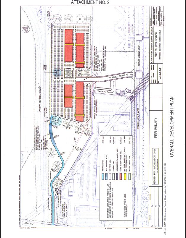
2 CITY OF VAUGHAN EXTRACT FROM COUNCIL MEETING MINUTES OF OCTOBER 30, 2012 Item 31, CW Report No. 39 Page 2 Steeles West Plan will accommodate 5,500 residential units, 120,000 square metres of office/commercial space and subway station The Steeles West Secondary Plan area is bounded by Steeles Avenue to the south, Hydro Corridor and Canadian National Railway right-of-way to the north, Jane Street to the west and Keele Street to the east as shown on Attachment No. 1. At full build out, the Plan is expected to accommodate approximately 5,500 residential units and 120,000 square metres of office/commercial uses thereby generating a residential population of approximately 11,000 people and an estimated 5,000 employees. The area is currently comprised of vacant land with some existing low-rise employment uses including the United Parcel Service operations building east of Jane Street. There are significant public and private developments currently underway within the area, including the TYSSE Steeles West Subway Station, a York Region Transit (YRT) Bus Terminal and commuter parking lot. In addition, an active site development application for the vacant lands west of Keele Street is currently under review and consideration by staff. On-going subway construction provides opportunity to advance the construction of elements of the ultimate infrastructure needs for the Steeles West Plan The construction of the Steeles West Subway Station building and underground subway box is currently underway. Construction of the YRT bus terminal, commuter parking lot, passenger pickup/drop off and Street C will be included in the second phase of TYSSE construction for this area. Based on recent discussions with TTC staff, it is anticipated the detailed design and tender for phase two construction works will occur over the next six months. Street C is part of the primary north-south road network within the Steeles West Plan linking to the York University lands south of Steeles Avenue. The ultimate vision for Street C is to serve as a primary north-south multi-modal transportation corridor within the Steeles West Plan. Given the immediate proximity of Street C to the Steeles West Subway Station, YRT Bus Terminal and commuter parking lot, it is likely that development activity along this corridor will occur in conjunction with, or soon after opening day for the subway. The relationship between Street C and the overall plan for the Steeles West area, subway station, bus terminal and commuter parking lot is illustrated on Attachment No 2. A four lane roadway will be built and funded as part of the subway project The projected traffic volumes associated with the subway station and commuter parking lot requires four lanes of capacity on Street C on opening day; accordingly, the TYSSE project has identified the following base municipal infrastructure elements for Street C to be fully funded by the project: 26 metre right-of-way Pavement structure to accommodate four general purpose traffic lanes Fully urbanized cross section including concrete curb and gutter Streetlighting to City standards Concrete sidewalk along the west boulevard A temporary turn-around facility or suitable alternative at the north limit of Street C to accommodate larger vehicles such as snow ploughs and garbage trucks Storm sewers and watermain as required to service Street C, the subway station, bus terminal and commuter parking lot TTC has advised that the City will be responsible for the cost of any additional municipal infrastructure beyond the base elements, which the City may want, constructed in conjunction with the project. /3
3 CITY OF VAUGHAN EXTRACT FROM COUNCIL MEETING MINUTES OF OCTOBER 30, 2012 Item 31, CW Report No. 39 Page 3 City staff has negotiated for bike lanes on Street C to be built concurrently with the subway project at the City s cost In reviewing the TYSSE Project base case design elements, a number of ultimate design considerations for Street C were considered by staff, including: Ultimate multi-modal transportation objectives Pedestrian realm Facilitation of development Constructability, land requirements Financial implications Based on this review, staff is recommending that the ultimate right-of-way configuration for Street C should include a four lane cross-section, dedicated on-street bicycle lanes, and ample space for high quality streetscape furnishings and pedestrian zones. A 26.0 metre right-of-way will be required to accommodate these features. The provision of dedicated bike lanes on Street C is in keeping with the objectives of the Vaughan Official Plan and Transportation Master Plan, and will provide safety for cyclists by separating cyclists from traffic. Street C will become a busy corridor as it is the main access point for the subway station and commuter parking lot. In addition to good public transit links, the City is encouraging commuters to use active transportation to reduce the need to use the car for commuting and local trips. The east-west corridors in the Steeles West area will also have cycle facilities providing connectivity to the bike lanes on Street C, as well as the local and surrounding areas. Construction of the bike lanes concurrently with the road construction will minimize future disruptions due to construction activities along the proposed subway alignment and allow opportunities for development to proceed in a timely manner and in support of the anticipated inservice date for the subway extension to the VMC area. Accordingly, staff supports the need to advance the ultimate roadway construction to include on-street bike lanes along Street C. The City s is to reimburse TTC for the design and construction of the bike lanes on Street C TTC provided a preliminary cost estimate for the widening of the pavement structure on Street C to provide for the on-street bike lanes (inclusive of detailed design and construction), which amounted to approximately $176,000. TTC has requested the City formally confirm the availability of funding for this additional work before advancing the design of the infrastructure. Relationship to Vaughan Vision 2020/Strategic Plan In consideration of the strategic priorities related to Vaughan Vision 2020, the recommendations of this report will assist in: The pursuit of excellence in service delivery; Planning and managing growth, and economic vitality; and The demonstration of leadership and promotion of effective governance. Specific Strategic Plan Initiatives applicable to the recommendations made in this report include Vaughan s corporate priorities to support and plan high capacity transit at strategic locations throughout the City. Accordingly, this report is consistent with the priorities previously set by Council. /4
4 CITY OF VAUGHAN EXTRACT FROM COUNCIL MEETING MINUTES OF OCTOBER 30, 2012 Item 31, CW Report No. 39 Page 4 Regional Implications York Region is a funding partner for the Toronto-York Spadina Subway Extension project. Conclusion Construction of Street C to a four lane cross-section is required for opening day of the TYSSE project. Accordingly, the scope of this work will be designed, constructed and paid by the TYSSE project. The City is responsible to pay the cost of the additional road widening needed to facilitate on-street bike lanes. The TTC has requested confirmation the City will reimburse the funds for the incremental cost associated with this work before the construction contract is awarded. Accordingly, it is recommended that Council authorize staff to reimburse the TTC the certified cost attributable to providing bike lanes on Street C with funding from Capital Project DT Attachments 1. Steeles West Secondary Plan Location Map 2. Overall Development Plan Report prepared by: Michael Frieri, Manager of Engineering Planning & Studies Ext (A copy of the attachments referred to in the foregoing have been forwarded to each Member of Council and a copy thereof is also on file in the office of the City Clerk.)
5 COMMITTEE OF THE WHOLE OCTOBER 16, 2012 TORONTO-YORK SPADINA SUBWAY EXTENSION (TYSSE) STEELES WEST SECONDARY PLAN STREET C CONSTRUCTION WARD 4 VICINITY NORTH OF STEELES AVENUE BETWEEN JANE AND KEELE Recommendation The Commissioner of Engineering and Public Works, in consultation with the Commissioner of Finance / City Treasurer recommends: 1. THAT Council authorize staff to reimburse the Toronto Transit Commission the certified cost attributable to the additional widening of Street C to accommodate on-street bike lanes as recommended by the Commissioner of Engineering and Public Works with funding from Capital Project DT Contribution to Sustainability The Toronto-York Spadina Subway Extension (TYSSE) project will provide higher order transit infrastructure to support compact urban form and will offer an alternative mode of transportation to the single occupant vehicle. In addition, the subway extension into the City will stimulate the establishment of transit orientated development within the Steeles West Secondary Plan Area and the Vaughan Metropolitan Centre. The TYSSE is committed to applying sustainability standards in the design and construction of the subway project. Economic Impact The TYSSE has advised that the incremental cost associated with widening Street C to accommodate on-street bike lanes has been estimated to be approximately $176,000. Approved Capital Project DT (Steeles West Station Infrastructure TYSSE) allocates $3,000,000 for the design and construction of infrastructure required to support the Steeles West Subway Station, with funding from City-wide Development Charges. Accordingly, there are sufficient budgeted funds to cover this expense. Communications Plan The TYSSE Project Team will be advised of the approved recommendations originating from this report. Purpose The purpose of this report is to seek approval to reimburse the Toronto Transit Commission (TTC) for the incremental cost associated with the construction of bike lanes on Street C in the Steeles West Secondary Plan area. Background - Analysis and Options The TYSSE Project is currently under construction and scheduled to open for full revenue service to the Steeles West Secondary Plan area by late Steeles West Plan will accommodate 5,500 residential units, 120,000 square metres of office/commercial space and subway station
6 The Steeles West Secondary Plan area is bounded by Steeles Avenue to the south, Hydro Corridor and Canadian National Railway right-of-way to the north, Jane Street to the west and Keele Street to the east as shown on Attachment No. 1. At full build out, the Plan is expected to accommodate approximately 5,500 residential units and 120,000 square metres of office/commercial uses thereby generating a residential population of approximately 11,000 people and an estimated 5,000 employees. The area is currently comprised of vacant land with some existing low-rise employment uses including the United Parcel Service operations building east of Jane Street. There are significant public and private developments currently underway within the area, including the TYSSE Steeles West Subway Station, a York Region Transit (YRT) Bus Terminal and commuter parking lot. In addition, an active site development application for the vacant lands west of Keele Street is currently under review and consideration by staff. On-going subway construction provides opportunity to advance the construction of elements of the ultimate infrastructure needs for the Steeles West Plan The construction of the Steeles West Subway Station building and underground subway box is currently underway. Construction of the YRT bus terminal, commuter parking lot, passenger pickup/drop off and Street C will be included in the second phase of TYSSE construction for this area. Based on recent discussions with TTC staff, it is anticipated the detailed design and tender for phase two construction works will occur over the next six months. Street C is part of the primary north-south road network within the Steeles West Plan linking to the York University lands south of Steeles Avenue. The ultimate vision for Street C is to serve as a primary north-south multi-modal transportation corridor within the Steeles West Plan. Given the immediate proximity of Street C to the Steeles West Subway Station, YRT Bus Terminal and commuter parking lot, it is likely that development activity along this corridor will occur in conjunction with, or soon after opening day for the subway. The relationship between Street C and the overall plan for the Steeles West area, subway station, bus terminal and commuter parking lot is illustrated on Attachment No 2. A four lane roadway will be built and funded as part of the subway project The projected traffic volumes associated with the subway station and commuter parking lot requires four lanes of capacity on Street C on opening day; accordingly, the TYSSE project has identified the following base municipal infrastructure elements for Street C to be fully funded by the project: 26 metre right-of-way Pavement structure to accommodate four general purpose traffic lanes Fully urbanized cross section including concrete curb and gutter Streetlighting to City standards Concrete sidewalk along the west boulevard A temporary turn-around facility or suitable alternative at the north limit of Street C to accommodate larger vehicles such as snow ploughs and garbage trucks Storm sewers and watermain as required to service Street C, the subway station, bus terminal and commuter parking lot TTC has advised that the City will be responsible for the cost of any additional municipal infrastructure beyond the base elements, which the City may want, constructed in conjunction with the project.
7 City staff has negotiated for bike lanes on Street C to be built concurrently with the subway project at the City s cost In reviewing the TYSSE Project base case design elements, a number of ultimate design considerations for Street C were considered by staff, including: Ultimate multi-modal transportation objectives Pedestrian realm Facilitation of development Constructability, land requirements Financial implications Based on this review, staff is recommending that the ultimate right-of-way configuration for Street C should include a four lane cross-section, dedicated on-street bicycle lanes, and ample space for high quality streetscape furnishings and pedestrian zones. A 26.0 metre right-of-way will be required to accommodate these features. The provision of dedicated bike lanes on Street C is in keeping with the objectives of the Vaughan Official Plan and Transportation Master Plan, and will provide safety for cyclists by separating cyclists from traffic. Street C will become a busy corridor as it is the main access point for the subway station and commuter parking lot. In addition to good public transit links, the City is encouraging commuters to use active transportation to reduce the need to use the car for commuting and local trips. The east-west corridors in the Steeles West area will also have cycle facilities providing connectivity to the bike lanes on Street C, as well as the local and surrounding areas. Construction of the bike lanes concurrently with the road construction will minimize future disruptions due to construction activities along the proposed subway alignment and allow opportunities for development to proceed in a timely manner and in support of the anticipated inservice date for the subway extension to the VMC area. Accordingly, staff supports the need to advance the ultimate roadway construction to include on-street bike lanes along Street C. The City s is to reimburse TTC for the design and construction of the bike lanes on Street C TTC provided a preliminary cost estimate for the widening of the pavement structure on Street C to provide for the on-street bike lanes (inclusive of detailed design and construction), which amounted to approximately $176,000. TTC has requested the City formally confirm the availability of funding for this additional work before advancing the design of the infrastructure. Relationship to Vaughan Vision 2020/Strategic Plan In consideration of the strategic priorities related to Vaughan Vision 2020, the recommendations of this report will assist in: The pursuit of excellence in service delivery; Planning and managing growth, and economic vitality; and The demonstration of leadership and promotion of effective governance. Specific Strategic Plan Initiatives applicable to the recommendations made in this report include Vaughan s corporate priorities to support and plan high capacity transit at strategic locations throughout the City. Accordingly, this report is consistent with the priorities previously set by Council.
8 Regional Implications York Region is a funding partner for the Toronto-York Spadina Subway Extension project. Conclusion Construction of Street C to a four lane cross-section is required for opening day of the TYSSE project. Accordingly, the scope of this work will be designed, constructed and paid by the TYSSE project. The City is responsible to pay the cost of the additional road widening needed to facilitate on-street bike lanes. The TTC has requested confirmation the City will reimburse the funds for the incremental cost associated with this work before the construction contract is awarded. Accordingly, it is recommended that Council authorize staff to reimburse the TTC the certified cost attributable to providing bike lanes on Street C with funding from Capital Project DT Attachments 1. Steeles West Secondary Plan Location Map 2. Overall Development Plan Report prepared by: Michael Frieri, Manager of Engineering Planning & Studies Ext Respectfully submitted, Paul Jankowski, P.Eng. Andrew Pearce, C.E.T. Commissioner of Engineering Director of Development / And Public Works Transportation Engineering
9
10
Transportation Impacts: Toronto York Spadina Subway Extension
 STAFF REPORT ACTION REQUIRED Transportation Impacts: Toronto York Spadina Subway Extension Date: June 6, 2011 To: From: Wards: Reference Number: North York Community Council Director, Transportation Services
5 REQUEST FOR GRADE-SEPARATED PEDESTRIAN UNDERPASS CROSSINGS OF LESLIE STREET AND ST. JOHN S SIDEROAD TOWN OF AURORA
 5 REQUEST FOR GRADE-SEPARATED PEDESTRIAN UNDERPASS CROSSINGS OF LESLIE STREET AND ST. JOHN S SIDEROAD TOWN OF AURORA The Transportation Services Committee recommends the adoption of the recommendations
CITY OF VAUGHAN EXTRACT FROM COUNCIL MEETING MINUTES OF NOVEMBER 15, 2016
 CITY OF VAUGHAN EXTRACT FROM COUNCIL MEETING MINUTES OF NOVEMBER 15, 2016 Item 6, Report No. 38, of the Committee of the Whole, which was adopted without amendment by the Council of the City of Vaughan
Transportation Master Plan Advisory Task Force
 Transportation Master Plan Advisory Task Force Network Alternatives & Phasing Strategy February 2016 BACKGROUND Table of Contents BACKGROUND Purpose & Introduction 2 Linking the TMP to Key Council Approved
CITY OF VAUGHAN EXTRACT FROM COUNCIL MEETING MINUTES OF NOVEMBER 21, 2017
 CITY OF VAUGHAN EXTRACT FROM COUNCIL MEETING MINUTES OF NOVEMBER 21, 2017 Item 9, Report No. 39, of the Committee of the Whole, which was adopted without amendment by the Council of the City of Vaughan
4 DISRUPTION MANAGEMENT PLAN HIGHWAY 7 RAPIDWAY CONSTRUCTION BETWEEN BAYVIEW AVENUE AND WARDEN AVENUE TOWNS OF MARKHAM AND RICHMOND HILL
 4 DISRUPTION MANAGEMENT PLAN HIGHWAY 7 RAPIDWAY CONSTRUCTION BETWEEN BAYVIEW AVENUE AND WARDEN AVENUE TOWNS OF MARKHAM AND RICHMOND HILL The Transportation Services Committee recommends the adoption of
Toronto and East York Community Council. Director, Transportation Services, Toronto and East York District
 No Turn on Red Regulations STAFF REPORT ACTION REQUIRED Date: June 1, 2010 To: From: Toronto and East York Community Council Director, Transportation Services, Toronto and East York District Wards: Trinity
4 Ridership Growth Study
 Clause 4 in Report No. 15 of Committee of the Whole was adopted, without amendment, by the Council of The Regional Municipality of York at its meeting held on November 16, 2017. 4 Ridership Growth Study
APPENDIX 2 LAKESHORE ROAD TRANSPORTATION REVIEW STUDY EXECUTIVE SUMMARY
 APPENDIX 2 LAKESHORE ROAD TRANSPORTATION REVIEW STUDY EXECUTIVE SUMMARY Appendix 2 City of Mississauga Lakeshore Road FINAL REPORT Transportation Review Study December 2010 EXECUTIVE SUMMARY Study Purpose
Sixth Line Development - Transit Facilities Plan
 Memorandum Date: November 13, 2012 To: From: c.c. Subject: Rob Freeman (Freeman Planning) Kevin Phillips Sixth Line Development - Transit Facilities Plan 33016631 This memo was prepared to review the transit
Road Alterations - Wellington Street East, Church Street, and Front Street Intersection
 REPORT FOR ACTION Road Alterations - Wellington Street, Church Street, and Front Street Intersection Date: November 1, 2016 To: Toronto and York Community Council From: Director, Public Realm Section,
Construction Staging Area Vaughan Road
 REPORT FOR ACTION Construction Staging Area - 109 Vaughan Road Date: May 25, 2017 To: Toronto and East York Community Council From: Acting Director, Transportation Services, Toronto and East York District
York Region Population and Employment Growth
 March 1, 2016 1 York Region Population and Employment Growth York Region needs to comply with The Provincial Growth Plan and new forecasts introduced to 2036 and 2041 2 Regional Official Plan Review York
2 BOLTON COMMUTER RAIL SERVICE FEASIBILITY STUDY
 2 BOLTON COMMUTER RAIL SERVICE FEASIBILITY STUDY The Planning and Economic Development Committee recommends the adoption of the recommendations contained in the following report dated April 15, 2011 from
Prepared For: Shieldbay Developments Inc. c/o Matson, McConnell Ltd. 2430A Bloor Street West Toronto, Ontario M6S 1P9.
 Prepared For: Shieldbay Developments Inc. c/o Matson, McConnell Ltd. 2430A Bloor Street West Toronto, Ontario M6S 1P9 Prepared By: URS Canada Inc. 4 th Floor, 30 Leek Crescent Richmond Hill, Ontario L4B
CITY OF BLOOMINGTON COMPLETE STREETS POLICY
 CITY OF BLOOMINGTON COMPLETE STREETS POLICY POLICY OBJECTIVE: The City of Bloomington will enhance safety, mobility, accessibility and convenience for transportation network users of all ages and abilities,
Transportation Assessment
 Transportation Assessment Midtown Open House February 10, 2018 Overview Midtown in Focus Overview & Purpose of Today Transportation Assessment overview Summary of Transportation work to date Review & Analysis
Improving Cyclist Safety at the Dundas Street West and Sterling Road Intersection
 STAFF REPORT ACTION REQUIRED Improving Cyclist Safety at the Dundas Street West and Sterling Road Intersection Date: August 17, 2012 To: From: Wards: Reference Number: Public Works and Infrastructure Committee
CITY OF VAUGHAN EXTRACT FROM COUNCIL MEETING MINUTES OF APRIL 19, 2017
 CITY OF VAUGHAN EXTRACT FROM COUNCIL MEETING MINUTES OF APRIL 19, 2017 Item 22, Report No. 13, of the Committee of the Whole, which was adopted without amendment by the Council of the City of Vaughan on
Public Works and Infrastructure Committee. General Manager, Transportation Services
 STAFF REPORT ACTION REQUIRED Extending the Bay Street Bicycle Lanes Date: May 16, 2013 To: From: Public Works and Infrastructure Committee General Manager, Transportation Services Wards: Toronto Centre
WELCOME TO OPEN HOUSE # 1 June 14, 2017
 Langstaff Road Weston Road to Highway 7 Class Environmental Assessment Study WELCOME TO OPEN HOUSE # 1 June 14, 2017 Please sign in and join our mailing list Purpose of Open House #1 & Study Area York
Harbord Street and Hoskin Avenue Bicycle Lane Upgrades
 STAFF REPORT ACTION REQUIRED and Bicycle Lane Upgrades Date: April 22, 2014 To: From: Wards: Reference Number: Public Works and Infrastructure Committee General Manager, Transportation Services 19 and
WELCOME! To the Centennial Neighbourhoods Secondary Plan and Transportation Management Plan Information Centre. City of Hamilton
 WELCOME! To the Centennial Neighbourhoods Secondary Plan and Transportation Management Plan Information Centre City of Hamilton Public Information Centre #2 Dec 1, 2015 CENTENNIAL NEIGHBOURHOODS SECONDARY
University of Victoria Campus Cycling Plan Terms of Reference. 1.0 Project Description
 University of Victoria Campus Cycling Plan Terms of Reference 1.0 Project Description The Campus Cycling Plan, a first for the University, will provide a comprehensive and coordinated approach to support
Proposed Bridge Street East Bicycle Lanes Public Open House Thursday, April 27, 2017
 WELCOME Proposed Bridge Street East Bicycle Lanes Public Open House Thursday, April 27, 2017 Purpose of the Open House The purpose of this Open House is to gain public input on the bicycle lanes proposed
Bicycle Traffic Control Signal - St. Clair Avenue West and Poplar Plains Road
 PW17.11 REPORT FOR ACTION Bicycle Traffic Control Signal - St. Clair Avenue West and Poplar Plains Road Date: November 4, 2016 To: Public Works and Infrastructure Committee From: Acting General Manager,
Chapter 7. Transportation. Transportation Road Network Plan Transit Cyclists Pedestrians Multi-Use and Equestrian Trails
 Chapter 7 Transportation Transportation Road Network Plan Transit Cyclists Pedestrians Multi-Use and Equestrian Trails 7.1 TRANSPORTATION BACKGROUND The District of Maple Ridge faces a number of unique
Building Great Neighbourhoods BELLEVUE AND VIRGINIA PARK
 Building Great Neighbourhoods BELLEVUE AND VIRGINIA PARK This is Meeting 2 Unfortunately, some residents in Bellevue and Virginia Park received the wrong information for this public open house (Meeting
CITY OF COCOA BEACH 2025 COMPREHENSIVE PLAN. Section VIII Mobility Element Goals, Objectives, and Policies
 CITY OF COCOA BEACH 2025 COMPREHENSIVE PLAN Section VIII Mobility Element Goals, Objectives, and Policies Adopted August 6, 2015 by Ordinance No. 1591 VIII MOBILITY ELEMENT Table of Contents Page Number
WELCOME. Purpose of the Open House. Update you on the project. Present a draft recommended plan. Receive your input
 WELCOME Purpose of the Open House The Town of Smiths Falls has initiated the Beckwith Street Redevelopment Plan that includes the preparation of a streetscape functional design for the renewal of Beckwith
a) receiving of legal advice subject to solicitor client privilege and labour relations regarding contract negotiations
 receiving of legal advice subject to solicitor client privilege and labour relations regarding contract negotiations") Regional Municipality of Waterloo Planning and Works Committee Agenda Tuesday, April 4, 2017 9:30 a.m. (Following Closed Session) Regional Council Chamber 150 Frederick Street, Kitchener Media Release:
Regional Municipality of Waterloo Planning and Works Committee Agenda Tuesday, April 4, 2017 9:30 a.m. (Following Closed Session) Regional Council Chamber 150 Frederick Street, Kitchener Media Release:
Governance and Priorities Committee Report For the July 2, 2015 Meeting
 CITY OF VICTORIA For the July 2, 2015 Meeting To: Governance and Priorities Committee Date: From: Subject: Brad Dellebuur, A/Assistant Director, Transportation and Parking Services Executive Summary The
St. John's Sideroad and Leslie Street Trail System Underpasses
 Office of the Clerk John D. Leach Director of Customer and Legislative ServicesfTown Clerk 905-727-3123 ext. 4771 ileach@aurora.ca Town of Aurora 1 00 John West Way, Box 1 000 Aurora, ON L4G 6J1 August
APPENDIX G: INTERSECTION NEEDS AT OKEECHOBEE BOULEVARD
 APPENDIX G: INTERSECTION NEEDS AT OKEECHOBEE BOULEVARD INTERSECTION NEEDS AT SR 7 and OKEECHOBEE BOULEVARD SR 7 Extension Project Development and Environment (PD&E) Study From Okeechobee Boulevard (SR
Chair and Members of Transportation Standing Committee. Bruce Zvaniga, P.Eng., Director, Transportation and Public Works
 P.O. Box 1749 Halifax, Nova Scotia B3J 3A5 Canada Item No. 12.1.1 Transportation Standing Committee December 7, 2017 TO: Chair and Members of Transportation Standing Committee SUBMITTED BY: ORIGINAL SIGNED
Corporate. Report COUNCIL DATE: June 26, 2006 NO: C012 COUNCIL-IN-COMMITTEE. TO: Mayor & Council DATE: June 22, 2006
 Corporate NO: C012 Report COUNCIL DATE: June 26, 2006 COUNCIL-IN-COMMITTEE TO: Mayor & Council DATE: June 22, 2006 FROM: General Manager, Engineering FILE: 0410-20(MoT/Gate) SUBJECT: Surrey Response on
Public Event 1 Community Workshops
 Public Event 1 Community Workshops Nov. 24 & Dec. 3, 2016 Welcome Workshop Purpose We re looking to you for ideas and insights to help guide future transportation infrastructure planning in the Park Lawn
Circulation in Elk Grove includes: Motor vehicles, including cars and trucks
 Circulation, as it is used in this General Plan, refers to the many ways people and goods move from place to place in Elk Grove and the region. Circulation in Elk Grove includes: Motor vehicles, including
Developing a Birmingham Transport Space Allocation policy. David Harris Transport Policy Manager Economy Directorate Birmingham City Council
 Developing a Birmingham Transport Space Allocation policy David Harris Transport Policy Manager Economy Directorate Birmingham City Council Birmingham s Sustainable Urban Mobility Plan Birmingham Connected
102 Avenue Corridor Review
 February 26, 2015 102 Avenue Corridor Review Transportation Association of Canada Road Safety Engineering Award Submission for the City of Edmonton Introduction Transportation Association of Canada Road
8 PROPOSED ROUNDABOUT DUFFERIN STREET AND KING VAUGHAN ROAD INTERSECTION CITY OF VAUGHAN
 8 PROPOSED ROUNDABOUT DUFFERIN STREET AND KING VAUGHAN ROAD INTERSECTION CITY OF VAUGHAN The Transportation Services Committee recommends the adoption of the recommendation contained in the following report
TORONTO TRANSIT COMMISSION REPORT NO.
 Revised: March/13 TORONTO TRANSIT COMMISSION REPORT NO. MEETING DATE: January 28, 2014 SUBJECT: IMPROVING PEDESTRIAN SAFETY AND CUSTOMER JOURNEY TIMES: TRANSIT STOPS ACTION ITEM RECOMMENDATIONS It is recommended
Service Business Plan
 Service Business Plan Service Name Transportation Planning Service Type Public Service Owner Name Kaylan Edgcumbe Budget Year 2019 Service Owner Title Service Description Manager of Transportation Planning
BICYCLE PROGRAM IMPLEMENTATION UPDATE. Transportation and Trinity River Project Council Committee June 13, 2016
 BICYCLE PROGRAM IMPLEMENTATION UPDATE Transportation and Trinity River Project Council Committee Purpose 01 Provide background and a status update on onstreet bicycle facility planning and implementation
Item No Halifax Regional Council January 16, 2018 January 30, 2018
 P.O. Box 1749 Halifax, Nova Scotia B3J 3A5 Canada Item No. 9.2.1 Halifax Regional Council January 16, 2018 January 30, 2018 TO: Mayor Savage and Members of Halifax Regional Council Original Signed SUBMITTED
P.O. Box 1749 Halifax, Nova Scotia B3J 3A5 Canada Item No. Halifax Regional Council January 16, 2017
 P.O. Box 1749 Halifax, Nova Scotia B3J 3A5 Canada Item No. Halifax Regional Council January 16, 2017 TO: Mayor Savage and Members of Halifax Regional Council SUBMITTED BY: Jacques Dubé, Chief Administrative
Chapter 5 Future Transportation
 Chapter 5 Future Transportation The Future Land Use Plan identifies the desired land use designations. The land uses desired for Crozet depend, in large part, on the success of the transportation system,
Purpose: Financial Implications and Impact Statement: It is estimated that the cost to implement:
 Various Modifications Lower Jarvis Street and Lake Shore Boulevard East; Lower Jarvis Street, east side, between Lake Shore Boulevard East and The Esplanade - 45-77 Lower Jarvis Street; and Lower Jarvis
Chapter 3 DESIGN SPECIFICATIONS
 Brampton PathWays Planning and Design Guidelines 27 Chapter 3 DESIGN SPECIFICATIONS 3.1 CLASS 1 MULTI-USE PATH Off-road multi-use trails are the backbone of the Brampton PathWays Network. They are typically
We believe the following comments and suggestions can help the department meet those goals.
 The Honorable Secretary Anthony Foxx The Secretary of Transportation United States Department of Transportation 1200 New Jersey Avenue, SE Washington, DC 20590 August 30, 2013 Dear Secretary Foxx, Thank
CHAIR AND MEMBERS CIVIC WORKS COMMITTEE MEETING ON JANUARY 10, 2017
 TO: FROM: SUBJECT: CHAIR AND MEMBERS CIVIC WORKS COMMITTEE MEETING ON JANUARY 10, 2017 KELLY SCHERR, P.ENG., MBA, FEC MANAGING DIRECTOR ENVIRONMENTAL & ENGINEERING SERVICES AND CITY ENGINEER QUEENS AVENUE
2.0 LANE WIDTHS GUIDELINE
 2.0 LANE WIDTHS GUIDELINE Road Engineering Design Guidelines Version 2.0.1 May 2018 City of Toronto, Transportation Services City of Toronto Page 0 Background In early 2014, Transportation Services initiated
Building Great Neighbourhoods BONNIE DOON
 Building Great Neighbourhoods BONNIE DOON We Are Here Today To Explain the Neighbourhood Renewal Process Show you the Westwood Preliminary Design Ask for local knowledge Highlight the Local Improvement
TRANSPORTATION NEEDS ASSESSMENT
 TRANSPORTATION NEEDS ASSESSMENT A travel demand analysis was carried out to determine the operational issues and the potential benefit that adding traffic capacity would have on the road network. All the
CITY OF KINGSTON INFORMATION REPORT TO ENVIRONMENT, INFRASTRUCTURE & TRANSPORTATION POLICIES COMMITTEE Report No.: EITP
 CITY OF KINGSTON INFORMATION REPORT TO ENVIRONMENT, INFRASTRUCTURE & TRANSPORTATION POLICIES COMMITTEE TO: FROM: RESOURCE STAFF: Chair and Members of Environment, Infrastructure & Transportation Policies
CITY OF HAMILTON PLANNING AND ECONOMIC DEVELOPMENT DEPARTMENT Transportation Planning and Parking Division
 CITY OF HAMILTON PLANNING AND ECONOMIC DEVELOPMENT DEPARTMENT Transportation Planning and Parking Division TO: Chair and Members Public Works Committee COMMITTEE DATE: June 18, 2018 SUBJECT/REPORT NO:
Traffic Calming St. Clarens Avenue between Brandon Avenue and Davenport Road
 STAFF REPT ACTION REQUIRED Traffic Calming St. Clarens Avenue between Brandon Avenue and Davenport Road Date: February 2, 2012 To: From: Wards: Reference Number: Etobicoke York Community Council Acting
Why invest in the 1 Street S.W. Corridor?
 Why invest in the 1 Street S.W. Corridor? This project is an investment in the Beltline Community and Calgary s economy. It is anticipated that The City s investment along this corridor will help with
Appendix J Transportation Master Plan Assessment
 Appendix J 2002 Transportation Master Plan Assessment York Region Transportation Master Plan October 2009 ASSESSMENT OF 2002 YORK REGION TMP ACTION PLAN A Background Report By Cansult Limited December
Moving Cambridge. City of Cambridge Transportation Master Plan Public Consultation Centre. March 7, :00 8:00 PM.
 City of Cambridge Transportation Master Plan Public Consultation Centre March 7, 2018 5:00 8:00 PM Region of Waterloo City of Cambridge Transportation Master Plan Public Consultation Centre March 7, 2018
21.07 TRANSPORT CONNECTIVITY AND INFRASTRUCTURE
 21.07 TRANSPORT CONNECTIVITY AND INFRASTRUCTURE 21.07-1 Connectivity and Choice Transport connectivity and mode choice are critical to achieving productive, sustainable and socially just cities. Travel
Nomination. Halton Region in Context
 Transportation Association of Canada Sustainable Urban Transportation Award Nomination of: Region of Halton Regional Transportation Master Plan Study March 2005 Nominated by: Nomination The TAC Sustainable
REPORT. Engineering and Construction Department
 REPORT COMMUNITY SERVICES COMMITTEE MEETING DATE: JUNE 11, 2013 FROM: Engineering and Construction Department DATE: May 24, 2013 SUBJECT: Great Lakes Boulevard Mini Roundabout LOCATION: Great Lakes Boulevard
Climate Change Action Plan: Transportation Sector Discussion Paper: Cycling
 Climate Change Action Plan: Transportation Sector Discussion Paper: Cycling ontario.ca/climatechange Contents 1. Minister of Transportation s message... 3 2. Introduction... 5 3. Sector Overview and Support
CPC Parking Lot Riverside Drive. Transportation Rationale
 CPC Parking Lot Transportation Rationale Prepared By: NOVATECH Suite 200, 240 Michael Cowpland Drive Ottawa, Ontario K2M 1P6 September 2015 Novatech File: 114093 Ref: R-2015-153 Table of Contents 1.0 INTRODUCTION...
Classification Criteria
 SCHEDULE D TO RECOMMENDED OFFICIAL PLAN AMENDMENT NO. 40 SCHEDULE C-4 Road Criteria Criteria Traffic Service Objective Land Service/Access Typical Daily Traffic Volume Flow characteristics Travel Speed
TRANSPORTATION TOMORROW SURVEY
 Clause No. 15 in Report No. 7 of was adopted, without amendment, by the Council of The Regional Municipality of York at its meeting held on April 17, 2014. 15 2011 TRANSPORTATION TOMORROW SURVEY recommends
AIRPORT ROAD ENVIRONMENTAL ASSESSMENT
 WELCOME TO PUBLIC INFORMATION CENTRE #1 AIRPORT ROAD ENVIRONMENTAL ASSESSMENT From Braydon Boulevard/Stonecrest Drive to Countryside Drive November 23, 2017 6:30 PM 8:30 PM Please sign in and fill out
Building Great Neighbourhoods QUEEN ALEXANDRA
 Building Great Neighbourhoods QUEEN ALEXANDRA We are here today to Explain how the City is investing in improving your neighbourhood and how your neighbourhood will be improved to meet current City standards.
Markham Sports, Entertainment and Cultural Centre Transportation Overview
 Markham Sports, Entertainment and Cultural Centre Transportation Overview ARENA LOCATION 2 3 TRANSPORTATION VISION IN MARKHAM On April 12, 2011, Markham Council adopted a long-term Transportation Vision
Confirmation of Levels of Service for Winter Maintenance of Bikeways, Windrow Opening, Sidewalks and AODA Compliance
 STAFF REPORT ACTION REQUIRED Confirmation of Levels of Service for Winter Maintenance of Bikeways, Windrow Opening, Sidewalks and AODA Compliance Date: March 17, 2014 To: From: Wards: Reference Number:
Appendix 1 Transit Network Analysis
 Appendix 1 Transit Network Analysis APPENDIX 1 TRANSIT NETWORK ANALYSIS The purpose of this appendix is to provide an update on the transit network analysis as it pertains to: i. SmartTrack ii. Scarborough
Design of Stanley Park S-Curve
 ADMINISTRATIVE REPORT Date: May 4, 2001 TO: FROM: Author/Local: F. Klotzbach/7118 RTS NO. 01644 CC File No. Standing Committee on Transportation and Traffic General Manager of Engineering Services, in
Tonight is an opportunity to learn about the Study and ask questions of the Study Team members.
 Exhibit 1 Welcome Second Open House Tonight is an opportunity to learn about the Study and ask questions of the Study Team members. A first Public Open House was held on September 18th, 2013 which presented
Rebuilding Highway 7 Town Centre Boulevard to Sciberras Road
 Rebuilding Highway 7 Town Centre Boulevard to Sciberras Road Project Status Update Presentation to City of Markham Development Services Committee October 22, 2013 Presentation Outline Background Status
Omaha s Complete Streets Policy
 Omaha s Complete Streets Policy (Adopted August 2015) VISION To create great places and enhance our quality of life, the City of Omaha will provide safe, accessible streets for all users. Complete Streets
City of Waterloo Complete Streets Policy
 City of Waterloo Complete Streets Policy Chris Hodgson P. Eng City of Waterloo Complete Streets Forum 2011 April 28-29 Toronto Waterloo context: Current population Major employers Universities and student
Workshop Feedback Report
 Page 1 of 7 Workshop Feedback Report Stakeholder Workshop #1 Wednesday, August 19, 2015 Workshop Feedback Report This report outlines the key messages and input from the Stakeholder Workshop held on August
Thank you for attending the first Public Open House for the Thunder Bay Transportation Master Plan!
 Welcome Thank you for attending the first Public Open House for the Thunder Bay Transportation Master Plan! Please take this opportunity to learn about the study and to tell us your ideas and vision for
Basalt Creek Transportation Refinement Plan Recommendations
 Basalt Creek Transportation Refinement Plan Recommendations Introduction The Basalt Creek transportation planning effort analyzed future transportation conditions and evaluated alternative strategies for
Welcome. If you have any questions or comments on the project, please contact:
 Welcome This drop-in public open house is intended to provide information about the Bay Street bike lanes project. This project proposes a dedicated cycling facility along Bay Street between Aberdeen Avenue
Copenhagen Cycling Map. Red Lines Cycling facilities
 Copenhagen Cycling Map Red Lines Cycling facilities Copenhagen Cycling Facilities Design Approaches Transportation without Pollution Copenhagen s Strategy Where Cycling is one of the top key activities
A CHANGING CITY. of Edmonton, it is essential that it reflects the long-term vision of the City.
 A CHANGING CITY By the year 2040, Edmonton will be home to more than 1 million people. To accommodate growth and support a healthy and compact city, we need a new approach to development/redevelopment
2. Executing a legal agreement with respect to (1) above.
 above.") 3. INSTALLATION OF TRAFFIC CONTROL SIGNALS AT HUNT CLUB AND PAUL ANKA TO ACCOMMODATE THE DEVELOPMENT OF A GAS BAR, CONVENIENCE STORE AND CAR WASH COMMITTEE RECOMMENDATIONS That Council approve the installation
3. INSTALLATION OF TRAFFIC CONTROL SIGNALS AT HUNT CLUB AND PAUL ANKA TO ACCOMMODATE THE DEVELOPMENT OF A GAS BAR, CONVENIENCE STORE AND CAR WASH COMMITTEE RECOMMENDATIONS That Council approve the installation
Kelowna On the Move. Pedestrian and Bicycle Master Plan
 Kelowna On the Move Pedestrian and Bicycle Master Plan Executive Summary April 2016 Purpose of the Plan The Pedestrian and Bicycle Master Plan identifies infrastructure, planning, and policy requirements
CONNECTING PEOPLE TO PLACES
 CONNECTING PEOPLE TO PLACES 82 EAST BENCH MASTER PLAN 07 Introduction The East Bench transportation system is a collection of slow moving, treelined residential streets and major arteries that are the
7 Yonge and Steeles Area Regional Transportation Study City of Markham and City of Vaughan
 Clause 7 in Report No. 17 of Committee of the Whole was adopted, without amendment, by the Council of The Regional Municipality of York at its meeting held on November 19, 2015. 7 Yonge and Steeles Area
Exhibit 1 PLANNING COMMISSION AGENDA ITEM
 Exhibit 1 PLANNING COMMISSION AGENDA ITEM Project Name: Grand Junction Circulation Plan Grand Junction Complete Streets Policy Applicant: City of Grand Junction Representative: David Thornton Address:
Cycling Facilities on Woodbine Avenue and Corley Avenue
 PW15.10 REPORT FOR ACTION Cycling Facilities on and Corley Date: September 13, 2016 To: Public Works and Infrastructure Committee From: Acting General Manager, Transportation Services Wards: Ward 31 -
Sustainable Mobility in Greater Sudbury NeORA Conference September 25, 2012
 Sustainable Mobility in Greater Sudbury NeORA Conference September 25, 2012 Presented by: David Shelsted, MBA, P.Eng., Director of Roads & Transportation Services The City s Transportation Network Approximately
In station areas, new pedestrian links can increase network connectivity and provide direct access to stations.
 The Last Mile Planning for Pedestrians Planning around stations will put pedestrians first. Making walking to stations safe and easy is important; walking will be a part of every rapid transit Accessible
122 Avenue: 107 Street to Fort Road
 : 107 Street to Fort Road November 24, 2015 4:30 8:00 p.m. Meeting Purpose Summarize project work completed to date Share results of public input from Phase 1 Share the draft concept plan and proposed
West Dimond Blvd Upgrade Jodhpur Street to Sand Lake Road
 West Dimond Blvd Jodhpur St to Sand Lake CSS Transportation Project Summary Municipality of Anchorage Project # 05 005 Project Manager: John Smith, P.E. (MOA PM&E) Project Administrator: Julie Makela,
Implementing Complete Streets in Ottawa. Project Delivery Process and Tools Complete Streets Forum 2015 October 1, 2015
 Implementing Complete Streets in Ottawa October 1, 2015 The Essentials Complete Streets Implementation Framework will become part of the routine delivery of City transportation projects Approach uses every
Active Transportation Infrastructure Investment A Business Case
 Active Transportation Infrastructure Investment A Business Case In 2016, the Real Estate Foundation awarded the Capital Regional District a $50,000 grant for Shifting Gears: Land Use Change through Active
5. MODIFICATIONS AT JEANNE D ARC BOULEVARD/REGIONAL ROAD 174 INTERCHANGE INTERSECTION - PUBLIC HEARING COMMITTEE RECOMMENDATION
 5. MODIFICATIONS AT JEANNE D ARC BOULEVARD/REGIONAL ROAD 174 INTERCHANGE INTERSECTION - PUBLIC HEARING COMMITTEE RECOMMENDATION Having held a public hearing, that Council approve the preliminary designs
Highway 56 Traffic Study Rymal Road to Cemetery Road
 January 31, 2018 6:00 pm 8:00 pm Highway 56 Traffic Study Rymal Road to Cemetery Road City of Hamilton Public Meeting 2 2 Purpose of Public Meeting To review and obtain public input and comments on the
4. ENVIRONMENTAL IMPACT ANALYSIS 9. TRANSPORTATION AND TRAFFIC
 4. ENVIRONMENTAL IMPACT ANALYSIS 9. TRANSPORTATION AND TRAFFIC 4.9.1 INTRODUCTION The following section addresses the Proposed Project s impact on transportation and traffic based on the Traffic Study
REimagining Yonge (Sheppard to Finch) Municipal Class Environmental Assessment Study
 Municipal Class Environmental Assessment Study") PW26.6 REPORT FOR ACTION REimagining Yonge (Sheppard to Finch) Municipal Class Environmental Assessment Study Date: January 5, 2018 To: Public Works and Infrastructure Committee From: General Manager,
PW26.6 REPORT FOR ACTION REimagining Yonge (Sheppard to Finch) Municipal Class Environmental Assessment Study Date: January 5, 2018 To: Public Works and Infrastructure Committee From: General Manager,
Bloor Street Design Feasibility Study and Bike Lane Pilot Project. Public Works and Infrastructure Committee
 PW12.1 STAFF REPORT ACTION REQUIRED Design Feasibility Study and Bike Lane Pilot Project Date: March 30, 2016 To: From: Wards: Reference Number: Public Works and Infrastructure Committee General Manager,