MARKHOUSE ROAD IMPROVEMENTS
|
|
|
- Cameron Jones
- 5 years ago
- Views:
Transcription

1 MARKHOUSE ROAD IMPROVEMENTS
2 Waltham Forest is changing and we want you to be part of it. Thanks to a funding pot of 27million from Transport for London, we re delivering the Mini-Holland Programme to make our streets fit for everyone to use, whether you walk, cycle, use public transport or drive. The Mini-Holland Programme is about making our streets work for everyone and our borough a better place to live, work and travel. By creating designated space for cycling, creating routes that better connect our town centres, and redesigning some of our public areas, we want to cut down unnecessary traffic outside your home, and provide safer and healthier travel options so that people enjoy living and spending time in the borough. Over the last three years there have been 40 collisions on Markhouse Road and air pollution in Waltham Forest is on the increase. At peak times of the day, we have up to 6,000 extra cars on our roads due to the school run making our roads more congested than ever before. We need to do something about this so that everyone can get from A to B easily and safely. What s planned for Markhouse Road? The Mini-Holland Programme is made up of a network of walking and cycling routes, one of which is Markhouse Road. These routes aim to better connect areas within the borough such as our town centres and residential areas, making it easier for people to walk and cycle local journeys. The routes also help connect Waltham Forest to our neighbouring boroughs, attracting visitors to the borough and boosting business for our local economy. Markhouse Road forms part of the Leyton to Blackhorse Road walking and cycling route, which connects Forest Road and Leyton High Road. Running from St James Street to Lea Bridge Road, this part of the route is heavily used with over 19,000 vehicles and around 600 cyclists every day. We re now looking to modernise this part of the route to make travelling in the borough by bike and on foot easier and safer. We know that Markhouse Road is popular for people cycling from Leyton to Walthamstow, so we want to improve it by creating segregated areas where possible, making it safer and easier for everyone to share the road. We re also planning to put blended Copenhagen crossings in on a number of side streets, which extend the pavement across the road, helping to enforce the Highway Code by encouraging vehicles to give way to pedestrians and people on cycles. We ll also be investing in junctions, pedestrians crossings and bus stops, and will create attractive public spaces with more trees, making the area a more enjoyable place that people will want to use. We recognise that there is a place for cars in our borough, but want to make our roads safer by creating junctions that encourage drivers to slow down and take extra care at key points. What has happened so far? In October 2015, we looked at traffic and collision numbers on Markhouse Road to understand what changes need to be made to make the route safer. This information along with the plans proposed in the Mini-Holland bid document which we submitted to TfL to win the funding for the programme have been used to develop a set of proposals to improve the area. We want to involve the local community in shaping the plans and are now seeking feedback on the proposed improvements from residents and businesses, so that we can develop a scheme that meets the needs of the local community as a whole. As well as seeking your views, we will be in contact with key stakeholders including the emergency services to make sure the design enables them to do their important work day to day, and we will continue to engage with them as the scheme progresses. 2

3 Giving your views on the proposed design We want everyone who lives and works in the local area to have their say on the scheme design and help to shape the proposals. To help manage the consultation and feedback we receive, we re asking you to rate and comment on groups of proposals rather than individual changes, and to tell us what else you would like to see. Please read each proposal listed in this leaflet, and tell us your thoughts on each one by visiting or completing the accompanying questionnaire, if you requested a hardcopy leaflet. Depending on how much you write, we expect the survey to take no more than 10 minutes to complete. Please complete your feedback by 21 March PROPOSALS The key elements of the proposals are shown on the maps within this leaflet and outlined below. 1. New public spaces We want local people to enjoy spending time visiting the area as well as its shops and leisure facilities. As part of the Markhouse Road scheme, we want to improve the look and feel of the road between Boundary Road and 247 Markhouse Centre by transforming the long grass area into a new park space that people can walk and cycle through. To achieve this, we would like to make the following changes: Create a planted area to separate people walking and cycling from the road Introduce trees and a community growing scheme, where residents can plant their own crops and plants Improve the bus stop waiting area for bus passengers, by making the area bigger with better seats, an electronic bus timetable, and raising it so that accessing buses is easier for disabled people and people with bus chairs Create a wall mural to improve the attractiveness of the space, developed with the help of the community Improve the street lighting to help people feel safer Help local wildlife to thrive by planting more trees and meadow plants, and introducing bird boxes. 3 NEW PUBLIC SPACE ON MARKHOUSE ROAD
4 Proposed improvements 4
5 5
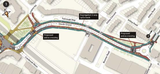
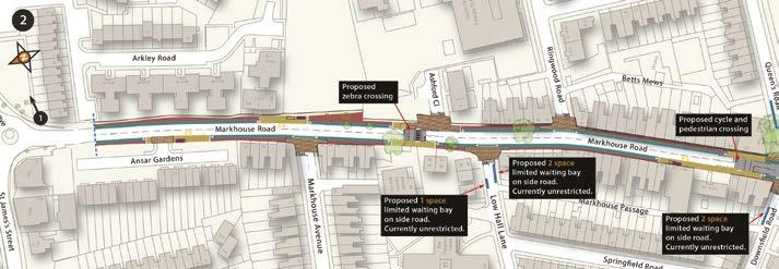
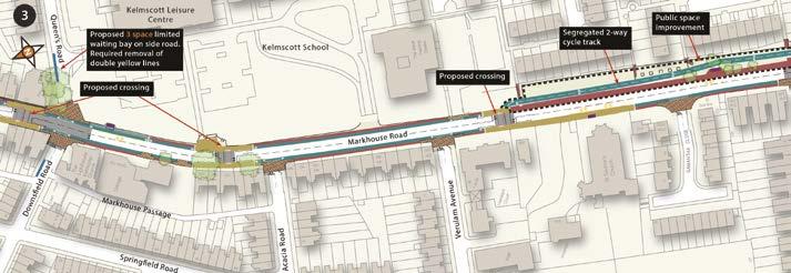
6 2. Creating a safer environment Over the last three years there have been 40 collisions recorded on Markhouse Road including three classed as serious. To address this, we want to make a number of road safety and junction improvements in the area, which help you get about easily and ensure pedestrians are prioritised at crossings. BLENDED COPENHAGEN CROSSINGS We re introducing a new style of crossing called blended Copenhagen crossings, which prioritise pedestrians at junctions. They are popular in Europe and extend the pavement across side streets at junctions, giving pedestrians a continuous pavement rather than a traditional kerb that they need to wait at before crossing the side road. This encourages vehicles to slow down when entering or exiting the side road, ensuring that pedestrians and people cycling have right of way, as per the Highway Code. We re proposing to install blended Copenhagen crossings at all side road junctions on Markhouse Road between Boundary Road and South Grove Road. Exact locations can be viewed on the map on page 4. NEW CROSSINGS To make the area safer for all road users, we also want to improve crossing points at the locations below: Create a new zebra crossing on the eastern side of the Markhouse Road/ South Grove roundabout to improve connections to St James Street, Selbourne Road and The Mall Raise the existing zebra crossing on the Markhouse Road/ South Grove roundabout to pavement level, to encourage vehicles to slow down when approaching the roundabout Create new signalised crossing points on Markhouse Road next to Ashford Close, Queens Road, Verulam Avenue, and on Ashford Close next to Theydon Street. This will improve access in the area for pedestrians and make it easier and safer to cross the road. 3. Cycle improvements We want to create protected cycle lanes on each side of the road to provide a safe space for people to cycle, separated from motorised traffic. This type of cycle lane makes it clearer and easier for everyone to share the road as the cycle track is higher than the road but lower than the pavement, helping drivers to feel more at ease and people cycling to feel safer. As well as improving cycle lanes, we ll also increase the number of signs to places of interest and cycle stands so people can get to and from this area easily. SOUTH GROVE Introduce segregated cycle lanes between Markhouse Road and Gosport Road to create a separate, designated space for cycling Widen the pavement surrounding the roundabout to accommodate the cycle lanes and make the area more appealing to pedestrians. MARKHOUSE ROAD Introduce a segregated cycle lane on both sides of the road between South Grove and Boundary Road to create a separate, designated space for cycling Widen the pavements on both sides of Markhouse Road to accommodate the cycle lane and make the area more appealing to pedestrians. 6
7 BOUNDARY ROAD CYCLE ROUTE For people cycling to and from Leyton, we have created a cycle route that will direct people away from the Markhouse Road/ Lea Bridge Road junction and along side streets. The cycle route will run along Markhouse Road from South Grove roundabout and take people cycling onto Boundary Road, then onto Northumberland Road before connecting to Manor Road on the other side of Lea Bridge Road. THEYDON STREET CYCLE ROUTE For those who want to cycle west along Lea Bridge Road and avoid the Markhouse Road/Lea Bridge Road junction, the cycle route will turn right onto Theydon Street then onto Hibbert Road, Bride Road, Hitcham Road and exit onto Lea Bridge Road. To provide a safe route for cycles we are proposing to make Theydon Street one way entry from Markhouse Road as shown on map four. 4. Bus stop upgrades We want to help improve the reliability of bus services and meet TfL s accessibility standards to better support elderly or disabled passengers, as well as people with push chairs. To do this, we re planning to improve bus stops, which will be designed together with the new cycle tracks. We want to improve public transport in the area to help encourage more people to use it, rather than driving as their first option. This will help relieve congestion on the road. We will continue to liaise with TfL who will approve any changes to bus stops. New bus stops and shelters will be introduced at the following locations, to make bus journeys more convenient and accessible: SOUTH GROVE To the west of Arkley Crescent (Westbound) To the east of the Markhouse Road (Eastbound). MARKHOUSE ROAD To the north of Markhouse Avenue (North/ Southbound) To the north of Downsfield Road (Northbound) To the south of Queens Road (Southbound) To the north and south of Samantha Close (North/ Southbound). 7
8 5. Parking and loading improvements It s important that parking and loading along Markhouse Road meets the needs of local residents, as well as businesses who are vital to the local economy. To accommodate the improvements to Markhouse Road, we have revised the current parking and loading arrangements and are proposing to remove 10 short term parking bays north of Downsfield Road, and relocate eight parking bays onto the following side streets: Three bays in Queens Road Two bays in Downsfield Road Three bays in Low Hall Lane. While this means two parking bays would not be relocated, a recent parking survey of the road showed that only 40 per cent of the parking bays are currently used during the day, which is about four vehicles a day. With this is mind, we feel that relocating eight parking spaces is enough to meet the demand in the area. To accommodate the new segregated cycle lane between Boundary Road and South Grove, the single yellow lines will be removed as the road will become too narrow to allow vehicles to park. For vehicles wishing to park near this section of Markhouse Road parking is allocated on the side streets. Take part in the consultation We hope you like the proposals and can see how they will benefit Markhouse Road for everyone. It s important that you help us shape the improvements by telling us your views. Please provide your feedback by 21 March There are a number of ways for you to have your say: Online visit to complete the questionnaire and provide comments online Request a hardcopy of the consultation document and questionnaire by ing miniholland@walthamforest.gov.uk or calling Come and talk to us and view the plans on: Monday 14 March 6pm to 9pm at Kelmscott School, 245 Markhouse Road, E17 8DN. What happens next? All of the feedback received will be grouped, carefully analysed and used to shape the final design. Where there are elements of the scheme that are not well supported by residents and businesses, we will look at these again. Where it s possible to make changes based on your comments and suggestions we will, and where we can t we will explain why. A summary of the results and feedback will be sent to everyone who took part after the public consultation stage has ended. This will set out the results and how they have been used to help shape the final design. This will also be available on the website for everyone to see. Before we get to the design stage, Transport for London (TfL) will also need to approve all of our plans as the funders of the Mini-Holland Programme. 8
LEA BRIDGE ROAD - A STREET FOR EVERYONE Public consultation document
 LEA BRIDGE ROAD - A STREET FOR EVERYONE Public consultation document TELL US Bakers Arms to Leyton Green Road (Section D, E, F) Leyton Green Road to Whipps Cross Roundabout (Section G) YOUR VIEWS www.enjoywalthamforest.co.uk
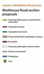
Leyton to Blackhorse Road Route Markhouse Road Section
 LONDON BOROUGH OF WALTHAM FOREST Meeting Date: PLM 14 April 2016 Title: Directorate: Report of: Contact: Mini Holland Leyton to Blackhorse Road Route Markhouse Road Section Neighbourhoods Head of Highways
CHURCH ROAD. Public consultation document TELL US YOUR VIEWS.
 CHURCH ROAD Public consultation document YOUR TELL US VIEWS www.enjoywalthamforest.co.uk CHURCH ROAD Introduction Waltham Forest Council was one of three boroughs to be awarded 27million of funding from
Lea Bridge Road A street for everyone Tell us
 Lea Bridge Road A street for everyone Tell us Public consultation document Section H your views 1 Lea Bridge Road: a street for everyone Introduction Mni-Holland is an exciting programme to improve walking
The Cabinet Member for Highways & Streetscene. Aurang Zeb - Head of Highways & Transport
 LONDON BOROUGH OF RICHMOND UPON THAMES Cabinet Member Decision DATE: January 2012 REPORT OF: LEAD OFFICER: SUBJECT: WARDS: The Cabinet Member for Highways & Streetscene Aurang Zeb - Head of Highways &
Bristol City Council has produced a draft Bristol Transport Strategy document.
 Bristol Transport Strategy Summary Document Introduction Bristol City Council has produced a draft Bristol Transport Strategy document. The Strategy fills a gap in transport policy for Bristol. We have
Walthamstow Village: trial results and workshop summary
 Walthamstow Village: trial results and workshop summary Introduction The London Borough of Waltham Forest was one of three boroughs awarded 30m by Transport for London (TfL) in March 2014 as part of the
BYRES ROAD: PUBLIC REALM Public Consultation
 Public Consultation Introduction As a vibrant commercial, shopping and residential location within the heart of the West End Byres Road is an important destination. Its proximity to the University of Glasgow
Nottingham Cycle City Frequently Asked Questions
 Nottingham Cycle City Frequently Asked Questions About the scheme How much money is to be spent on cycling? And where is the money from? We have 6.1 million in Growth Fund which we will be investing directly
Cabinet Member for Highways & Streetscene. Highway Infrastructure Manager
 LONDON BOROUGH OF RICHMOND UPON THAMES DATE: AUGUST 2015 DECISION MAKER: LEAD OFFICER: SUBJECT: WARDS: Cabinet Member for Highways & Streetscene Highway Infrastructure Manager PROPOSED CYCLING IMPROVEMENTS
HISTON ROAD Have your say on better public transport, cycling and walking journeys
 HISTON ROAD Have your say on better public transport, cycling and walking journeys Have your say: Please complete the survey inside this leaflet or online at www.greatercambridge.org.uk/histonconsultation
Guide to the Cycle Enfield Public Consultation on Enfield Town. Produced by the Save Our Enfield Town Campaign Group
 Guide to the Cycle Enfield Public Consultation on Enfield Town Produced by the Save Our Enfield Town Campaign Group What s in this guide? Introduction Page 3 What Enfield Council says about Option 1 Page
Chelmsford City Growth Package
 Chelmsford City Growth Package Public Consultation Document Volume 2 West Chelmsford July - August 2017 Chelmsford City Growth Package Public Consultation Document - Volume 2 - West Chelmsford Contents
London Cycle Network Annual Report 2000
 London Cycle Network Annual Report 2000 A cycle network for London by 2005 A cycle network for London by 2005 The London Cycle Network will: provide local links between residential neighbourhoods, railway
Public Consultation on Braintree Integrated Transport Package (ITP) HAVE YOUR. Consultation open from 24 September to 5 November 2018 SAY
 HAVE YOUR. Consultation open from 24 September to 5 November 2018 SAY") Public Consultation on Braintree Integrated Transport Package (ITP) HAVE YOUR SAY Consultation open from 24 September to 5 November 2018 Contents Introduction 3 Background 4 Springwood Drive Roundabout
Public Consultation on Braintree Integrated Transport Package (ITP) HAVE YOUR SAY Consultation open from 24 September to 5 November 2018 Contents Introduction 3 Background 4 Springwood Drive Roundabout
How do we design for pedestrians? Case study: transforming the Walworth Road
 How do we design for pedestrians? Case study: transforming the Walworth Road David Moores, Director of Public Realm Institution of Highways and Transportation, November 2009 Presentation overview Design
Milton Road Project Update. Paul van de Bulk 30 January 2018
 Milton Road Project Update Paul van de Bulk 30 January 2018 Milton Road Project Objectives Comprehensive priority for buses in both directions wherever practicable; Safer and more convenient routes for
ENFIELD TOWN THE REVISED DESIGN
 TOWN THE REVISED DESIGN We re turning Enfield into a borough that encourages walking and cycling, a place that s easy for all of us to get around however we choose to travel. A greener place, with safer
Cycle Superhighway 4 from Tower Bridge to Greenwich
 Cycle Superhighway 4 from Tower Bridge to Greenwich About Sustrans Sustrans is the charity making it easier for people to walk and cycle. We are engineers and educators, experts and advocates. We connect
MILTON ROAD LLF PROJECT UPDATE
 Greater Cambridge City Deal MILTON ROAD LLF PROJECT UPDATE 9 th May 2017 Project objectives Comprehensive priority for buses in both directions wherever practicable; Additional capacity for sustainable
WHANGAREI IMPROVEMENTS
 WHANGAREI IMPROVEMENTS PROJECT OVERVIEW The NZ Transport Agency (NZTA) is working with Whangarei District Council (WDC) to improve the state highway through Whangarei. In addition to the recently completed
CUERDEN TRANSPORT PROPOSALS
 1 CUERDEN TRANSPORT PROPOSALS The transport assessment, submitted with the Cuerden development planning application, looks at access to the site and the impact on the local road network in detail. This
2014/2015 BIKE ROUTE PLAN 83 AVENUE PROTECTED BIKE LANE
 About the Project 2014/2015 BIKE ROUTE PLAN The City of Edmonton is planning a major bike route on the south side of Edmonton. This bike route is one part of a plan to provide citizens with transportation
CAMBRIDGE SOUTH WEST PARK & RIDE
 CAMBRIDGE SOUTH WEST PARK & RIDE Have your say on: Extra Park & Ride spaces to the south west of Cambridge Bus priority measures into the city centre CREATING MORE PARK & RIDE SPACES The existing Park
ENJOY WALTHAM FOREST WALKING AND CYCLING ACCOUNT
 ENJOY WALTHAM FOREST WALKING AND CYCLING ACCOUNT www.enjoywalthamforest.co.uk ENJOY WALTHAM FOREST WALKING AND CYCLING ACCOUNT 2 www.enjoywalthamforest.co.uk Contents ENJOY WALTHAM FOREST WALKING AND CYCLING
Enjoy Waltham Forest. Cllr Clyde Loakes. Jon Little. Bespoke Transport Consulting. London Borough of Waltham Forest
 Enjoy Waltham Forest Jon Little Bespoke Transport Consulting Cllr Clyde Loakes London Borough of Waltham Forest Waltham Forest One of the 18 outer London boroughs, in north-east London Population of about
WEST HATCH HIGH SCHOOL THE BEST THAT I CAN BE. School Travel Plan
 WEST HATCH HIGH SCHOOL THE BEST THAT I CAN BE School Travel Plan Policy reviewed June 2017 TABLE OF CONTENTS Context... 3 Purpose... 3 Scope... 3 1.0 Introduction... 4 2.0 Existing Conditions... 4 3.0
March Maidstone Integrated Transport Strategy Boxley Parish Council Briefing Note. Context. Author: Parish Clerk 2 March 2016
 Context. Author: Parish Clerk 2 The Draft Integrated Transport Policy (DITS) sets out a vision and objectives, and identifies a detailed programme of interventions to support the Maidstone Borough Local
A127/A130 Fairglen Interchange Improvement Schemes. Information Leaflet February 2017
 A127/A130 Fairglen Interchange Improvement Schemes Information Leaflet February 2017 1 2 Foreword By Councillor Kevin Bentley Essex is continuing to grow as a vibrant economic hub and as a fantastic place
Sevenways Roundabout, and the need for a Road Safety Scheme:
 Sevenways Roundabout, and the need for a Road Safety Scheme: The way the current roundabout has evolved has obviously created an environment that is dangerous for all road users, motorists, cyclists and
Comments on the Hailsham to Eastbourne Sustainable Transport Corridor
 Comments on the Hailsham to Eastbourne Sustainable Transport Corridor Version 1.1 25/01/2015 Paul Humphreys 1 Table of Contents Version Control... 2 Summary... 2 Rationale provided by ESCC... 3 The ESCC
122 Avenue: 107 Street to Fort Road
 : 107 Street to Fort Road November 24, 2015 4:30 8:00 p.m. Meeting Purpose Summarize project work completed to date Share results of public input from Phase 1 Share the draft concept plan and proposed
IAN WHITE ASSOCIATES. Crawley Station Gateway Public Realm
 IAN WHITE ASSOCIATES Crawley Station Gateway Public Realm contents 1. objectives & client brief 2. site appraisal 3. best practice guidance 4. design concept 1. objectives & client brief Crawley Train
Low traffic neighbourhoods
 Low traffic neighbourhoods PHOTO: ELAINE KRAMER What, why, how? What low traffic neighbourhoods are, why you should be considering them in your borough and how to make sure they work well the five minute
High frequency bus services operating to Little Island; Creation of a new Park and Ride site and train station at North Esk;
 Cork County Council 7 th December 2018 Dear Adrian O Neill (aoneill@jbbarry.ie) The Transport and Mobility Forum, Cork (TMF) is a representative group of organisations who have a common interest in sustainable
Easton Safer Streets - Final Project Report BRISTOL
 - Final Project Report BRISTOL A Sustrans Community Street Design Project in partnership with Bristol City Council February 07 About Sustrans Sustrans makes smarter travel choices possible, desirable and
sessions. The opinions of local people will help decide which of these two options is taken forward to be built.
 A4018 FAQs Why are no bus lanes proposed north of Crow Lane? Inbound and outbound bus lanes were considered north of the Crow Lane junction, but they took away capacity from other traffic on the approach
The Consultation has now ended.
 The Consultation has now ended. We have received Cabinet Member approval to undertake implementation of the Baker Street Two Way scheme. You are not viewing the most recent documentation. Please visit
M6 Junction 10 Public Consultation
 M6 Junction 10 Public Consultation December 2015 Introduction Walsall Council and Highways England are developing plans to provide a long term improvement to M6 junction 10. We are holding this non-statutory
Quality Bus Corridor delivery report 1999/ /07
 Quality Bus Corridor delivery report 999/00 006/07 Quality Bus Corridor delivery report 999/00-006/07 Foreword Contents Welcome to the 006 delivery report on the Quality Bus Corridor programme. 84% of
Kingswood Primary School s Travel Plan
 Kingswood Primary School s Travel Plan Kingswood Primary School Cayser Drive Kingswood Maidstone Kent ME17 3QF 01622 842674 DCSF number 886-2578 Travel Plan Co-ordinator- Darren Waters ( headofschool@kingswood.kent.sch.uk)
Nottingham, the great cycle city
 Nottingham, the great cycle city Our vision for the city s cycling future Foreword Councillor Jon Collins Leader of the Council Nottingham has a world class public transport system which is essential to
HAMILTON BIKING PLAN OUR VISION: A BIKE FRIENDLY CITY
 HAMILTON BIKING PLAN 2015-2045 OUR VISION: A BIKE FRIENDLY CITY INTRODUCTION Biking as a travel option is experiencing a resurgence internationally and in New Zealand, growing as a familyfriendly and healthy
Living Streets response to the Draft London Plan
 Living Streets response to the Draft London Plan Contents Living Streets response to the Draft London Plan... 1 About Living Streets... 2 Summary... 2 Consultation response... 3 Chapter 1: Planning London
GLEN EIRA CITY COUNCIL. MURRUMBEENA Transforming our neighbourhood together our concepts based on your ideas
 GLEN EIRA CITY COUNCIL MURRUMBEENA Transforming our neighbourhood together our concepts based on your ideas 1 WHAT HAVE WE HEARD? WHAT NOW? Stage one Tell us what you love about your shopping strip November
Strategic Director for Environment. Enclosures Appendix A - Option drawings. Jamie Blake- Strategic Director for Environment
 Chipping Barnet Area Committee 9 July 2018 Title Report of Wards Status Urgent Key Cromer Road Request for 20mph Zone Strategic Director for Environment High Barnet Public No No Enclosures Appendix A -
Tonight is for you. Learn everything you can. Share all your ideas.
 Strathcona Neighbourhood Renewal Draft Concept Design Tonight is for you. Learn everything you can. Share all your ideas. What is Neighbourhood Renewal? Creating a design with you for your neighbourhood.
Mornington Crescent Junction (Cobden Junction)
") Mornington Crescent Junction (Cobden Junction) Public Consultation This consultation leaflet provides proposals on the next phase of the Camden Town Project at the southern part of Camden High Street and
Mornington Crescent Junction (Cobden Junction) Public Consultation This consultation leaflet provides proposals on the next phase of the Camden Town Project at the southern part of Camden High Street and
Oxfordshire Local Transport Plan 4 Science Vale Cycle Network Project Proposal Didcot Ladygrove Link
 Overview of project: The Ladygrove Link will provide a modern, direct, off-road, active travel route from the new Didcot North East development and new leisure centre to the strategic Cow Lane Tunnel.
Consultation Report & Results August 2016
 Queen Edith s Way Consultation Report & Results August 216 Summary The consultation on walking and cycling improvements along Queen Edith s Way took place from 2 June to 1 August 216. A total of 64 survey
TS 109 DURHAM ROAD QTC PHASE 4 PROJECT PROPOSAL. Page 1
 TS 109 DURHAM ROAD QTC PHASE 4 PROJECT PROPOSAL Page 1 Table of Contents 1.0 Introduction... 3 2.0 Project Overview... 3 3.0 Project Proposals... 4 3.1 Enfield Road / Durham Road Junction... 3 5 3.2 Summerfield
20mph. We want to make Edinburgh a better and safer place to live, work and play.
 20mph CREATING A BETTER SAFER EDINBURGH We want to make Edinburgh a better and safer place to live, work and play. That s why on 13 January 2015 Councillors approved a new speed limit network for Edinburgh
Frequently asked questions (FAQ) about a borough-wide 20 mph speed limit
 about a borough-wide 20 mph speed limit") Frequently asked questions (FAQ) about a borough-wide 20 mph speed limit February 2013 1. Is it safer to drive at 20 mph? Yes. According the Royal Society for Prevention of Accidents (RoSPA) if a pedestrian
Frequently asked questions (FAQ) about a borough-wide 20 mph speed limit February 2013 1. Is it safer to drive at 20 mph? Yes. According the Royal Society for Prevention of Accidents (RoSPA) if a pedestrian
Background. Caversham a vision for the future. Joint public meeting arranged by:
 Joint public meeting arranged by: Sharing our Streets Caversham a vision for the future and Caversham Traders Association This presentation followed a presentation by Simon Beasley, Network Manager for
Space for Cycling. A guide for decision makers
 Space for Cycling A guide for decision makers Why create Space for Cycling? Imagine your area with considerably less traffic. Imagine safe streets and neighbourhoods, clean air, young and old alike able
A105 Scheme. Consultation Report. Dated 29 January 2016
 A105 Scheme Consultation Report (Executive Summary plus additional annexes showing detailed methodology and qualitative analysis) Dated 29 January 2016 Contact Officer and telephone number: Richard Eason
CAMBOURNE TO CAMBRIDGE BETTER PUBLIC TRANSPORT PROJECT PHASE 2 PUBLIC CONSULTATION MADINGLEY MULCH ROUNDABOUT TO CAMBOURNE
 CAMBOURNE TO CAMBRIDGE BETTER PUBLIC TRANSPORT PROJECT PHASE 2 PUBLIC CONSULTATION MADINGLEY MULCH ROUNDABOUT TO CAMBOURNE Have your say on proposals for a new public transport link and Park & Ride facility
2014/2015 BIKE ROUTE PLAN 83 AVENUE PROTECTED BIKE LANE
 About the Project The City of Edmonton is planning a major bike route on the southside of Edmonton. The Strathcona Bike Route will connect the communities of Strathcona, Garneau and the University area,
Milton Road Bus Stop and Crossings Workshop WSP. 19th September 2017
 Bus Stop and Crossings Workshop WSP 19th September 2017 Workshop Aims Task 1: Identify preferences for bus stop designs relative to: (a) Ranking preference between 4 possible bus stop designs on the narrower
REF. PE01595: MORATORIUM ON SHARED SPACE SCHEMES
 PE1595/RRR Sustrans submission of 17 March 2017 Following the Public Petitions Committee meeting on 9 th February 2017 you wrote to Sustrans Scotland requesting a clarification on our position on the use
14. PROPOSED PEDESTRIAN CROSSING IMPROVEMENTS IN MOORHOUSE AVENUE
 165 14. PROPOSED PEDESTRIAN CROSSING IMPROVEMENTS IN MOORHOUSE AVENUE General Manager responsible: General Manager City Environment, DDI 941-8528 Officer responsible: Transport and Greenspace Unit Manager
Oxford Street West. 21 December https://consultations.tfl.gov.uk/roads/oxford-street/?cid=oxford-street
 Oxford Street West 21 December 2017 https://consultations.tfl.gov.uk/roads/oxford-street/?cid=oxford-street This consultation response is on behalf of the London Cycling Campaign (LCC), the capital s leading
New Seward and 36 th Avenue Intersection Conceptual Design
 University of Alaska Anchorage New Seward and 36 th Avenue Intersection Conceptual Design Prepared By: Zaid S. Hussein Dana Menendez Galen Jones Civil Engineering Department Prof. Osama Abaza CE A404 Highway
E4 Cycle Route Exeter University to Redhayes Bridge. - Recommendations from Exeter Cycling Campaign
 E4 Cycle Route Exeter University to Redhayes Bridge - Recommendations from Exeter Cycling Campaign 1.0 Introduction Exeter Cycling Campaign has prepared this report to provide recommendations for Devon
RESTRICTED ROADS (20 MPH SPEED LIMIT) (SCOTLAND) BILL. 1. Is reducing the speed limit to 20mph the best way of achieving the aims of the Bill?
 (SCOTLAND) BILL. 1. Is reducing the speed limit to 20mph the best way of achieving the aims of the Bill?") RURAL ECONOMY AND CONNECTIVITY COMMITTEE RESTRICTED ROADS (20 MPH SPEED LIMIT) (SCOTLAND) BILL SUBMISSION FROM CYCLE STIRLING Questions 1. Is reducing the speed limit to 20mph the best way of achieving
RURAL ECONOMY AND CONNECTIVITY COMMITTEE RESTRICTED ROADS (20 MPH SPEED LIMIT) (SCOTLAND) BILL SUBMISSION FROM CYCLE STIRLING Questions 1. Is reducing the speed limit to 20mph the best way of achieving
Governance and Priorities Committee Report For the July 2, 2015 Meeting
 CITY OF VICTORIA For the July 2, 2015 Meeting To: Governance and Priorities Committee Date: From: Subject: Brad Dellebuur, A/Assistant Director, Transportation and Parking Services Executive Summary The
Neighbourhood Development Plan: Ashtead INTRODUCTION 2 SUMMARY CONCLUSION CAR USE AND CONGESTION IN ASHTEAD 4
 CONTENTS Page INTRODUCTION 2 SUMMARY CONCLUSION 3 1.0 CAR USE AND CONGESTION IN ASHTEAD 4 1.1 Car Ownership and Methods of Travel to Work 4 1.2 Traffic Congestion in Ashtead 4 2.0 PARKING FACILITIES AND
1. TRANSFORM CITY ROAD WEST INTO A GREAT CENTRAL city street
 1. TRANSFORM CITY ROAD WEST INTO A GREAT CENTRAL city street Understanding City Road West City Road West (between Clarendon Street and ower Street) is a local street, and can be significantly enhanced
A52. Nottingham Junctions. Construction at Nottingham Road and Cropwell Road junctions commencing early January 2017
 Nottingham Junctions Construction at Nottingham Road and Cropwell Road junctions commencing early January 2017 Introduction The is the key east-west link across the East Midlands. The route is subject
Chelmsford City Growth Package
 Chelmsford City Growth Package Public Consultation Document Volume 5 South and East Chelmsford July - August 27 Chelmsford City Growth Package Contents Introduction 5 Army and Navy Roundabout Improvements:
Union Street roundabout Turbo-style roundabouts the future? Patrick Lingwood Walking and Cycling Officer Bedford Borough Council
 Union Street roundabout Turbo-style roundabouts the future? Patrick Lingwood Walking and Cycling Officer Bedford Borough Council Presentation outline Local importance and problems we faced The evolution
A52 Nottingham Junctions Nottingham Knight and Wheatcroft Public information exhibition
 Nottingham Junctions Nottingham Knight and Wheatcroft Public information exhibition Aerial view of Wheatcroft roundabout Introduction Investing in our roads At Highways England we believe in a connected
Community engagement guide May 2018
 Community engagement guide May 2018 Greater Wellington Regional Council (GWRC), Hutt City Council (HCC) and the New Zealand Transport Agency (NZTA) are working together to achieve some big improvements
Frascati Road and Temple Hill Route Improvements. Outline Design Report to Accompany Public consultation
 Frascati Road and Temple Hill Route Improvements Outline Design Report to Accompany Public consultation September 2013 Background: Dún Laoghaire-Rathdown is committed to providing high quality pedestrian
Douglas Land Use and Transportation Strategy (DLUTS) Summary. August 2013
 Summary. August 2013") Douglas Land Use and Transportation Strategy (DLUTS) Summary August 2013 Background Douglas is a large and popular residential suburb of approximately 30,000 persons on the periphery of Cork City along
Douglas Land Use and Transportation Strategy (DLUTS) Summary August 2013 Background Douglas is a large and popular residential suburb of approximately 30,000 persons on the periphery of Cork City along
WELLS WAY GREEN PARK ROAD
 FOBP Discussion Document February 2015 WELLS WAY GREEN PARK ROAD Wells Way looking from Albany Road through Burgess Park Introduction Burgess Park provides much needed and loved recreational space for
Launceston's Transport Futures. Greater travel options for the people of Launceston
 Launceston's Transport Futures Greater travel options for the people of Launceston Final Draft 13 Jan 2014 1 Page Number Executive summary 3 What is Transport Futures? 4 Vision 6 Economy, access and liveability
Yorkhill & Kelvingrove Community Council Cycling Village Proposal. Yorkhill Kelvingrove Cycling Village (1.3)
") Yorkhill Kelvingrove Cycling Village (1.3) 1) Introduction In recent years our community has been transformed. We have seen additional student and residential accommodation constructed. The redevelopment
Yorkhill Kelvingrove Cycling Village (1.3) 1) Introduction In recent years our community has been transformed. We have seen additional student and residential accommodation constructed. The redevelopment
M25 junction 28 improvement scheme. Have your say
 M25 junction 28 improvement scheme Have your say 14 November 2016 6 January 2017 M25 junction 28 improvement scheme Have your say About us IMAGE Highways England is the government company charged with
National Cycle Network Route 81 Wolverhampton Cross City Route August 2005
 Page 12 Buses often stop in Lichfield Street and there is no space to pass. Should an NCN route be following a road which is heavily congested with buses and diesel fumes? 14. Railway Drive The dropped
Developing a Birmingham Transport Space Allocation policy. David Harris Transport Policy Manager Economy Directorate Birmingham City Council
 Developing a Birmingham Transport Space Allocation policy David Harris Transport Policy Manager Economy Directorate Birmingham City Council Birmingham s Sustainable Urban Mobility Plan Birmingham Connected
Design Workshops Summary of all Feedback January 2017
 Histon Road Corridor Design Workshops Summary of all Feedback January 2017 CITY DEAL AND GROWTH Commitment to Growth: Government, County, City and District Emerging Local Plans: 33,000 new homes 45,000
Road Safety in Radyr and Morganstown: the Community Council's response to Cardiff Council's draft scheme layout for highway improvements
 Road Safety in Radyr and Morganstown: the Community Council's response to Cardiff Council's draft scheme layout for highway improvements Introduction Radyr and Morganstown Community Council has been invited
MILTON ROAD ~ MITCHAM'S CORNER PARAMICS MODEL INITIAL OPTION TESTING
 MILTON ROAD ~ MITCHAM'S CORNER PARAMICS MODEL INITIAL OPTION TESTING NOVEMBER 216 MILTON ROAD ~ MITCHAM'S CORNER PARAMICS MODEL INITIAL OPTION TESTING Cambridgeshire County Council Type of document (version)
TRANSPORT AND MOVEMENT
 TRANSPORT AND MOVEMENT Movement Strategy Public Transport Cycling and Walking Road Network Parking Standards Transport Impact Assessments Traffic Management Policies DRAFT POOLBEG PLANNING SCHEME Movement
Cycle Parking Standards TfL Proposed Guidelines
 Cycle Parking Standards TfL Proposed Guidelines A. Summary This document summarises recent research into London s cycle parking requirements and includes guidelines for identifying need appraising facilities,
CITY OF OTTAWA ROADWAY MODIFICATION APPROVAL UNDER DELEGATED AUTHORITY
 RMA-2015-ATM-038 CITY OF OTTAWA ROADWAY MODIFICATION APPROVAL UNDER DELEGATED AUTHORITY DATE: April 22, 2015 SUBJECT Approval of Roadway Modifications Recommended through an Area Traffic Management Study
Chapter 5. Complete Streets and Walkable Communities.
 Chapter 5. Complete Streets and Walkable Communities. 5.1 Description of Complete Streets. Cities throughout the world, and specifically the United States, are coming to embrace a new transportation and
GETTING WHERE WE WANT TO BE
 CAMBRIDGESHIRE & peterborough GETTING WHERE WE WANT TO BE A GREEN PARTY TRANSPORT POLICY CONTENTS Our Campaign Priorities 4 Bus Franchising 6 Supporting Active Transport 8 Workplace Parking Levy 9 Tackling
TRAVEL PLAN ANNUAL MONITORING REPORT
 Sustainability Services - Maintenance Services TRAVEL PLAN ANNUAL MONITORING REPORT 2017-18 Contents 1. Updated Travel Plan Action PLan...2 2. Completed Travel Plan Projects 2017-18...2 3. Planned Projects
DEPARTMENT OF ENVIRONMENTAL SERVICES. North Harrison Street (Lee Highway to Little Falls Road) Comparative Analysis. Prepared for:
 Comparative Analysis. Prepared for:") DEPARTMENT OF ENVIRONMENTAL SERVICES North Harrison Street (Lee Highway to Little Falls Road) Comparative Analysis Prepared for: Arlington County Department of Environmental Services 2100 Clarendon Boulevard,
DEPARTMENT OF ENVIRONMENTAL SERVICES North Harrison Street (Lee Highway to Little Falls Road) Comparative Analysis Prepared for: Arlington County Department of Environmental Services 2100 Clarendon Boulevard,
TRAVEL PLAN ANNUAL MONITORING REPORT
 Sustainability Services - Maintenance Services TRAVEL PLAN ANNUAL MONITORING REPORT 2017-18 Contents 1. Updated Travel Plan Action Plan...2 2. Travel Survey Results 2018...2 3. Usage Data For Travel Initiatives...2
Guildford Borough (Draft)
") ITEM Annex Page 7 Guildford Borough (Draft) Forward Programme Part A This is a work in progress and its completion is subject to the adoption of the Local Plan and Infrastructure Delivery Schedule November
ITEM Annex Page 7 Guildford Borough (Draft) Forward Programme Part A This is a work in progress and its completion is subject to the adoption of the Local Plan and Infrastructure Delivery Schedule November
Report to Cabinet. 18 May 2016
 Agenda Item 8 Report to Cabinet 18 May 2016 Subject: Presenting Cabinet Member: Proposed CCTV Enforcement of Traffic Contraventions in a Bus Lane (Key Decision Ref. No. HE030) Highways and Environment
City of Perth Cycle Plan 2029
 Bicycling Western Australia s response City of Perth Cycle Plan 2029 2012-2021 More People Cycling More Often ABOUT BICYCLING WESTERN AUSTRALIA Bicycling Western Australia is a community based, not-for-profit
Auckland Transport s responses to feedback on proposed upgrades to the intersection of Mercari way and Don Mckinnon Drive
 s to feedback on proposed upgrades to the intersection of way and Don Mckinnon Drive Points raised through feedback process 1 Congestion The proposal will improve traffic flow through the intersection
Cycle traffic and the Strategic Road Network. Sandra Brown, Team Leader, Safer Roads- Design
 Cycle traffic and the Strategic Road Network Sandra Brown, Team Leader, Safer Roads- Design Highways England A Government owned Strategic Highways Company Department for Transport Road Investment Strategy
9. Parking Supporting Statement
 9. Parking Supporting Statement Content 1. Setting the Scene 2. Vision 3. Parking and the Shared Priorities 4. Issues 5. Delivery Programme in the first Plan Period 2001/02 2005/06 6. Good Practice 7.
Wayfinding and Walking in London. Lilli Matson Transport for London May 2013
 Wayfinding and Walking in London Lilli Matson Transport for London May 2013 I want to make walking in London as attractive and enjoyable as possible by making walking count Mayor of London Boris Johnson
LET US KNOW WHAT YOU THINK
 A164 and Jock s Lodge Junction Improvement Scheme Funding Bid PUBLIC CONSULTATION November 2017 Public Exhibition to be held at Beverley Racecourse on Wednesday 8 th November 2017 between 9.30 am and 6.45