Kuujjua River. Introduction. Route Description. Words of Caution. edition 2012
|
|
|
- Rosalind Wilson
- 5 years ago
- Views:
Transcription
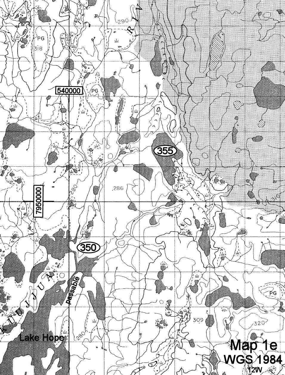
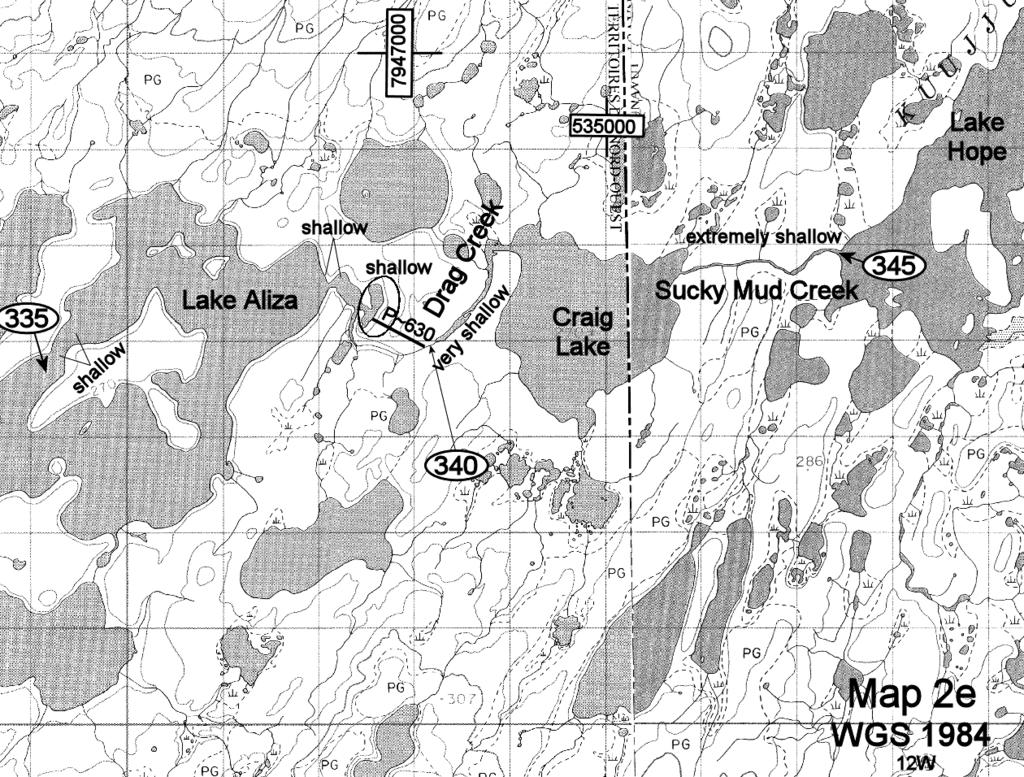
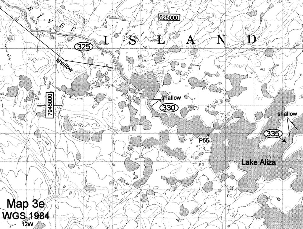
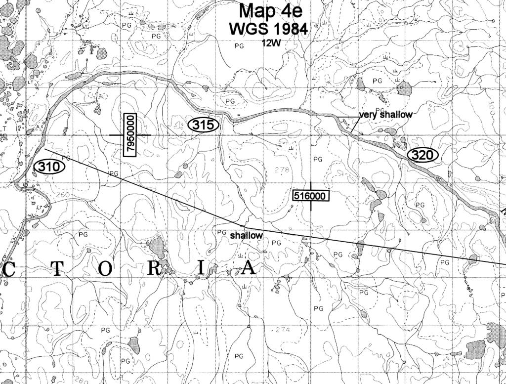
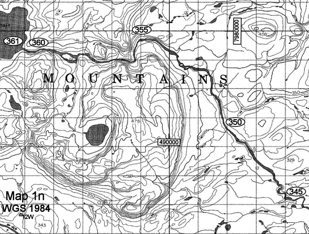
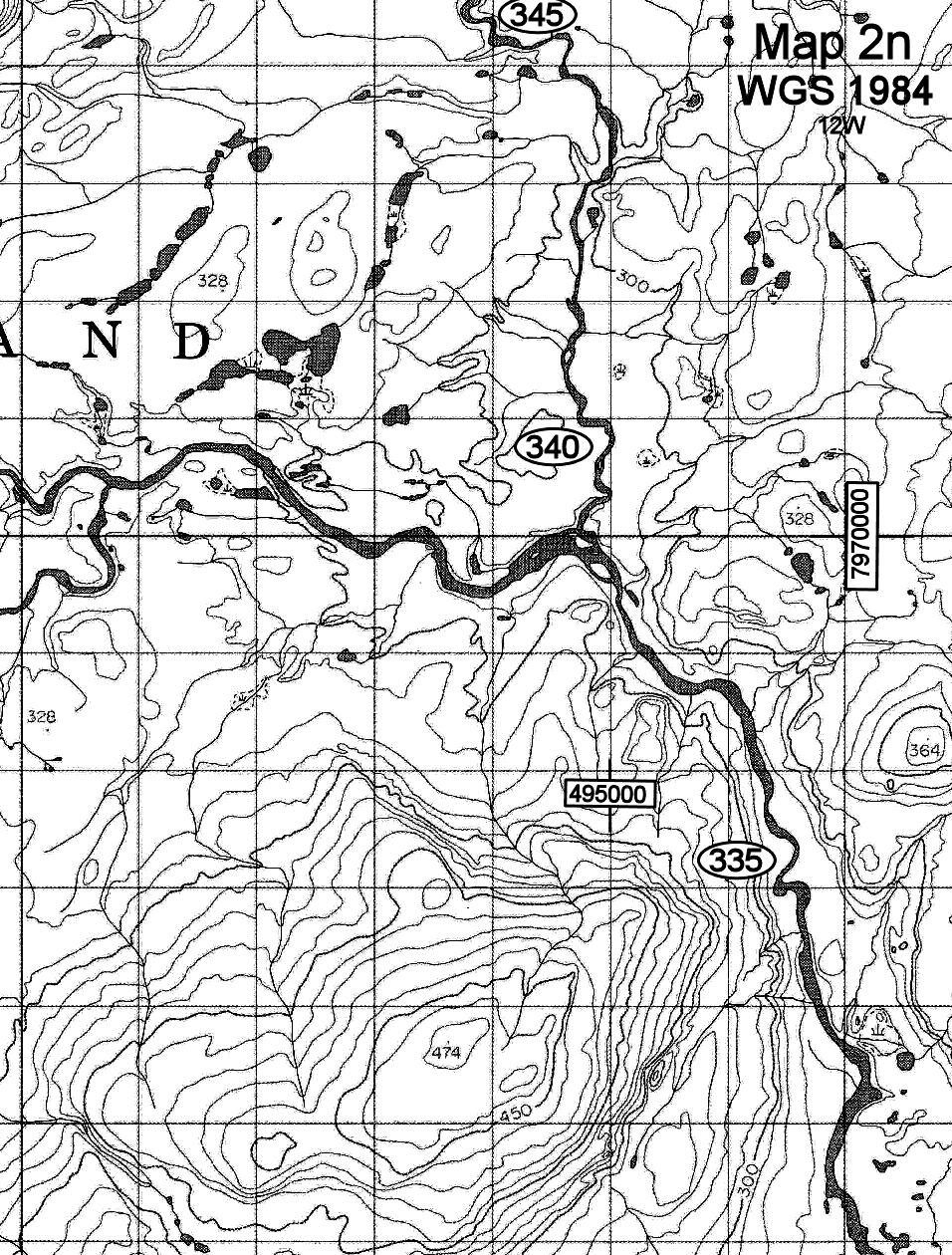
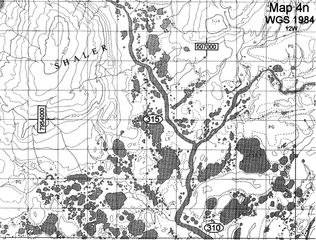
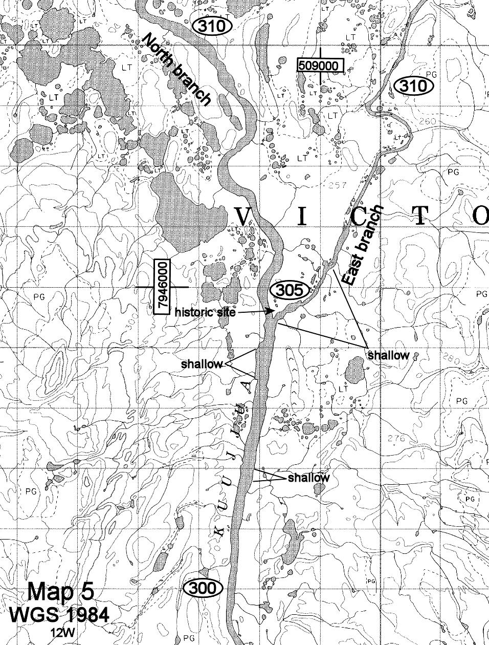
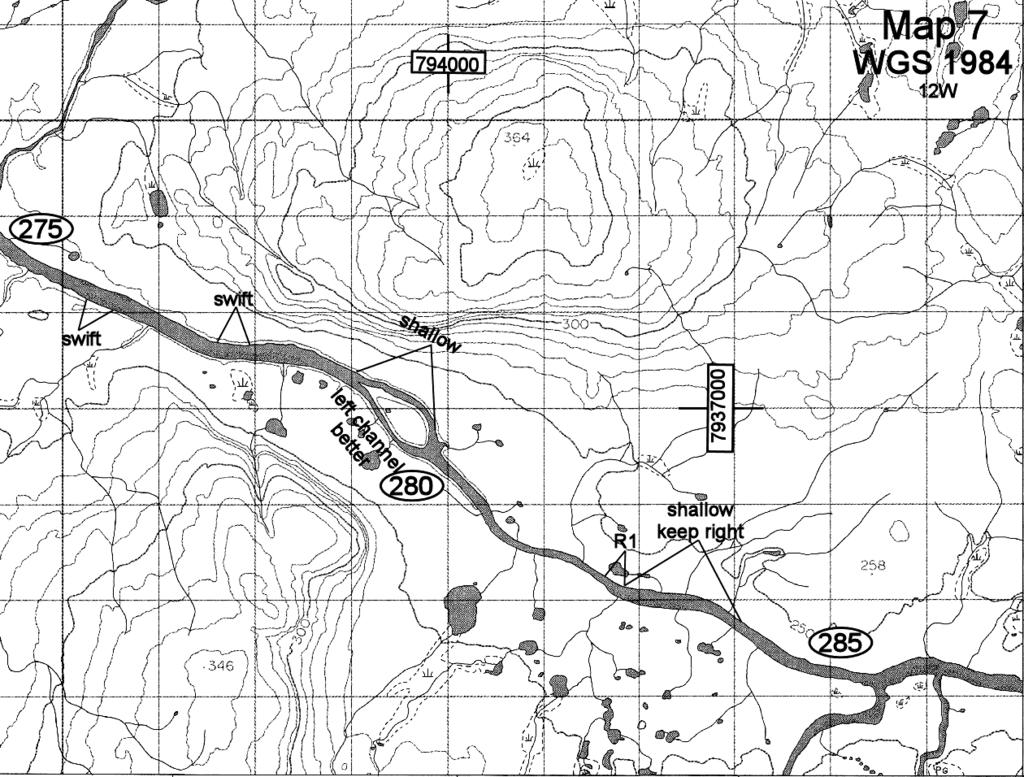
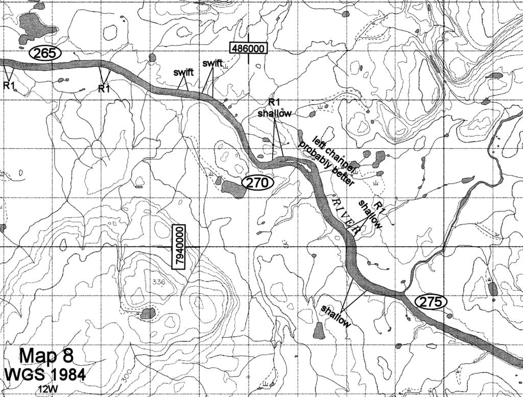
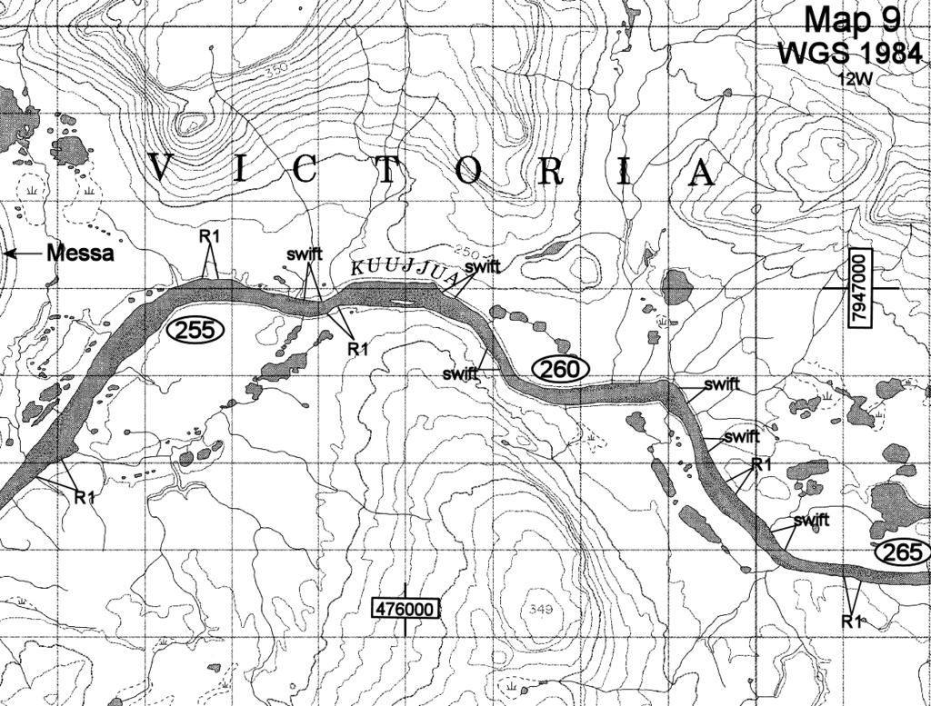
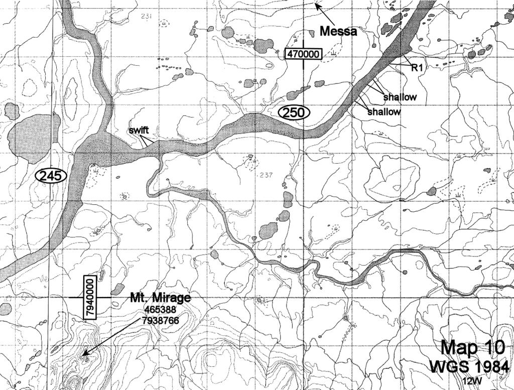
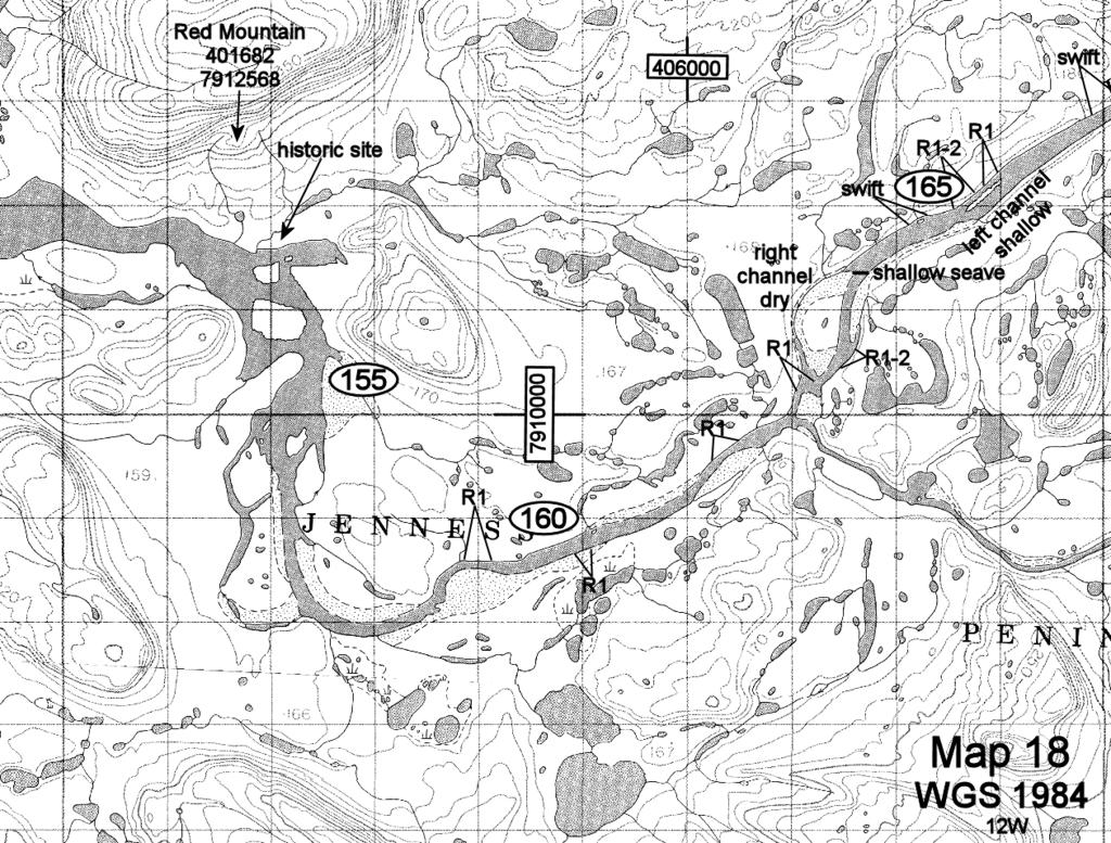
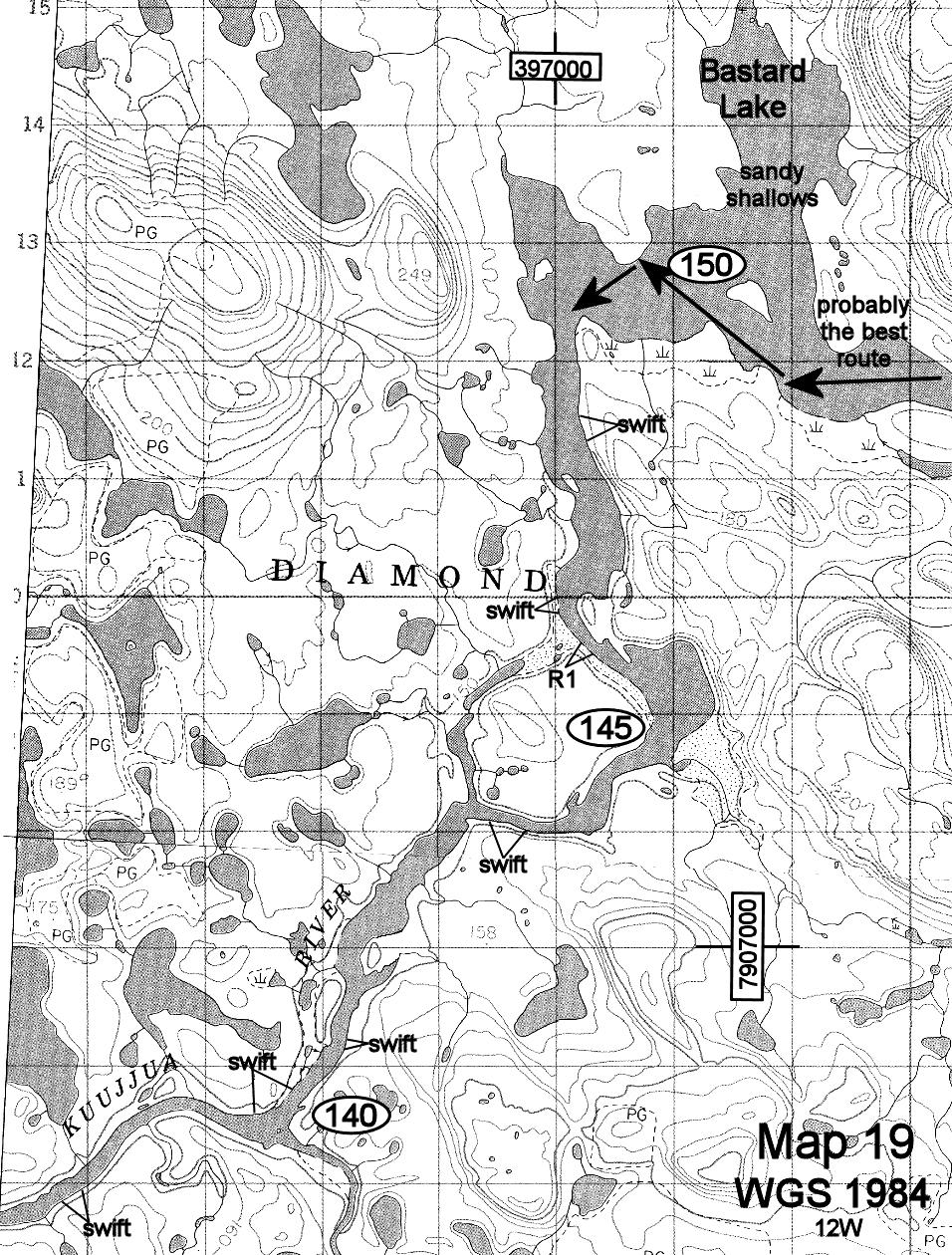
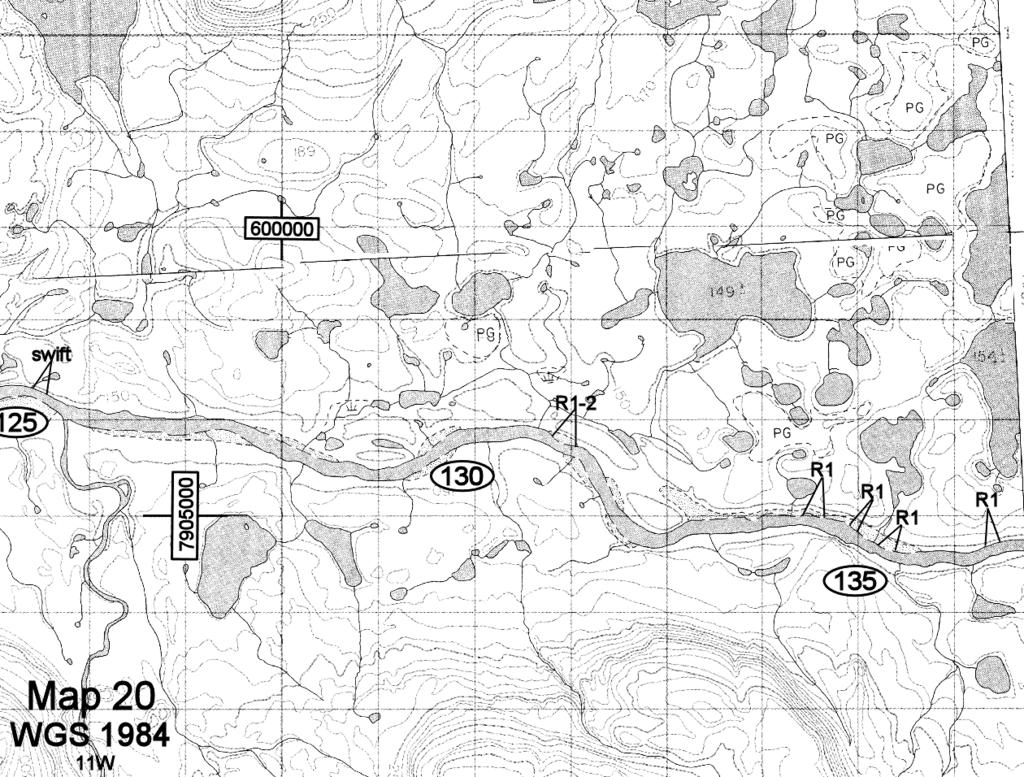
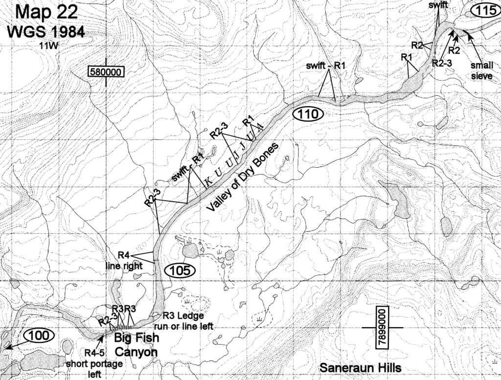
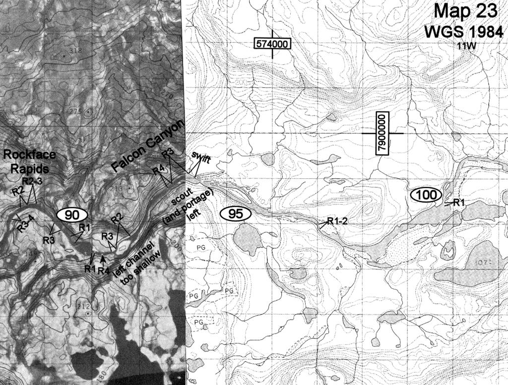
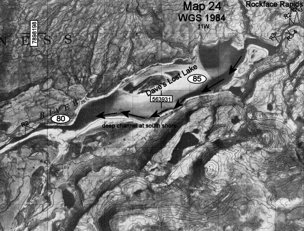
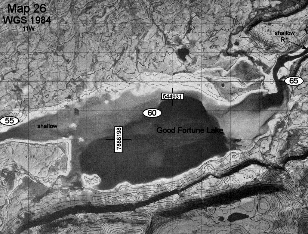
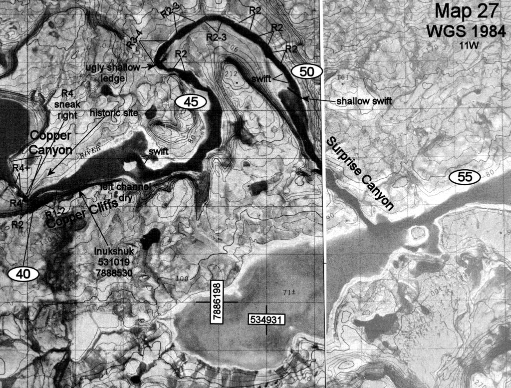
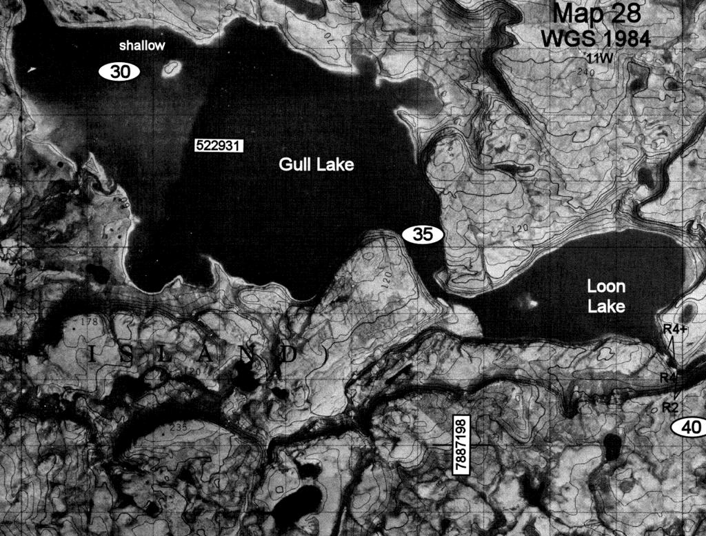
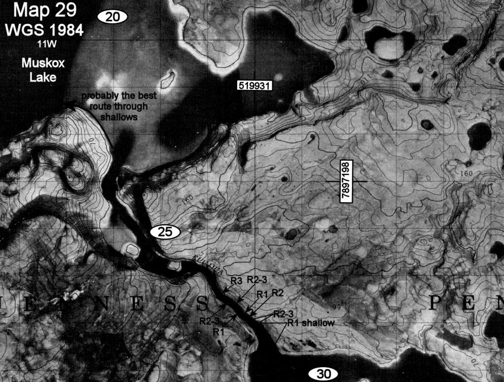
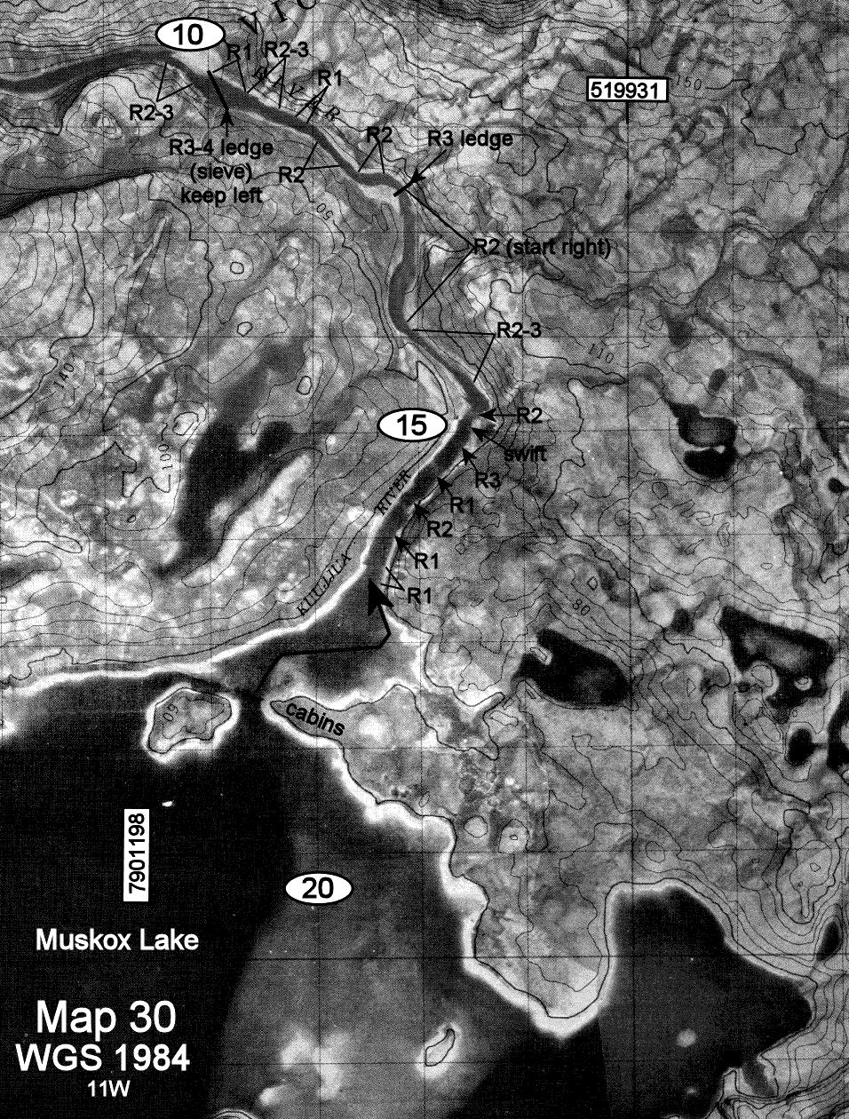
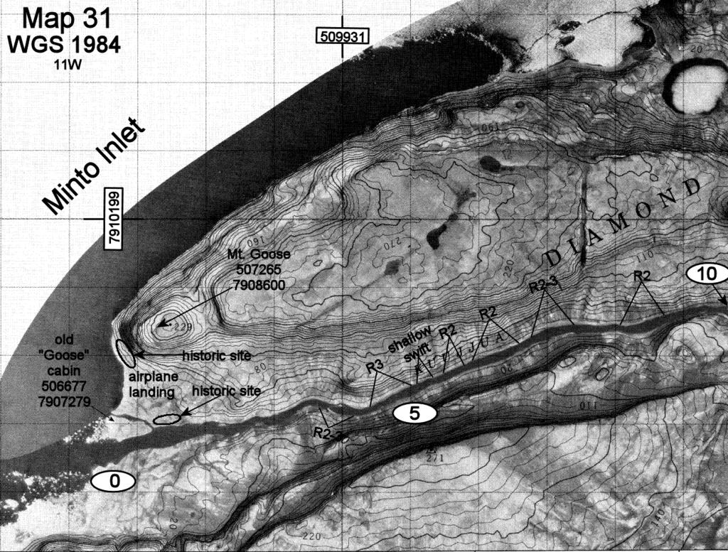
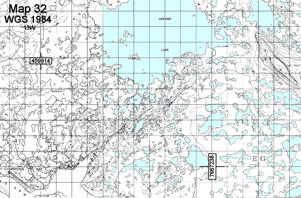
1 Kuujjua River Introduction Victoria Island (part of Western Canada's High Arctic island archipelago) is Canada's third-largest island, divided by an administrative line between the Northwest Territories and Nunavut. The Kuujjua River ("big river" in Inuktitut) originates in the center of Victoria Island and flows about 350 km into Minto Inlet on the island's west side. Beginning as a shallow stream, the river flows smoothly across rolling tundra, gaining speed and volume as it drops through rugged landscape, cutting canyons through basalt cliffs. Words of Caution These maps were created based on notes taken during our canoe trip in July 2012 (our trip report is available at We marked our maps according to what we saw at that time, in order to provide information to any future visitors, however, by no means do I take any responsibility for how this information will be used. I do not guarantee that it does not contain errors, whether made by me personally or by bugs in the software used. Rapid classification is subjective. Our subjective evaluation of the class level of these rapids does NOT take into account the remoteness of the region (i.e. distance and time from help etc.), the water temperature (cold kills) and the size and power of this river (any swim could be a very long swim). Moreover, the class of rapids depends on the water level and that can change immensely through the season. Use the information provided here with caution. YOU are the only one responsible for your own decisions and for your own safety. Rivers described here are wild and very remote. Weather can be also very tough. DO YOUR OWN scouting and reconnaissance. I am not taking any responsibility for the information provided here or for your safety. An Important Word from our lawyer The information conveyed here, on our maps, on our website and in our trip reports is the sole opinion and perspective of Lynette and/or Laco alone and should not be taken as a basis in fact. Many of L&L's observations during the period reported were made after only a very brief period, in very specific weather and water level conditions and often in a fatigued state. All readers are strongly encouraged and advised to do their own independent research (scouting) and form their own independent conclusions before deciding on any facts or actions in relation to any of L&L's freely published information. It is a well known fact that rivers can and do change completely, depending on multiple factors such as water levels, ice conditions, flood and/or drought conditions, continual erosion and altering seasonal and weather patterns. Each person who undertakes to travel any of these routes is responsible for their own judgments and safety. edition 2012 Route Description This river was mapped during our trip July 14 - August 1, We started at Lake Hope on the East branch of the river, still in Nunavut. For completeness, I provide also unmarked maps of the Northern branch, which should have slightly more water, but was beyond the range of the chartered Beaver we used for access. There is also a Southern branch of the river, which has been "paddled" once before (as far as we know), but it is reported to be extremely shallow and difficult to access. All of our rapid markings and ratings are subject to the water levels we had at that time. High water marks were evident all along the river, alerting us to the fact that this river would be extremely different and dangerous in high water. Some shore debris was on such high ground that we suspect the possibility of ice jams creating sudden, massive flash floods. This is treeless country & campsites abound, so there was no need to mark them on the maps. The River (and the whole area) is much shallower and there is much less precipitation and water drainage in general (than in Northern Quebec, where we are used to wetter conditions). We experienced a lot of walking and dragging especially during the first 3 days, but also towards the end of the journey, where aerial photographs were a huge help in navigating the shallow lakes successfully. Wildlife is abundant on the Kuujjua. With every turn of the river, you are likely to see muskox, arctic wolves, arctic foxes, snowy owls, arctic hares, and caribou. Dozens of bird species nest, from the tiny Lapland longspur to sandhill cranes, arctic loons, Sabine's gulls, white-fronted geese and tundra swans. Fishing is very good. The sun never sets during the arctic summer, but be careful to avoid paddling directly into the low sun late in the day (the Kuujjua flows generally west) - the reflection on the water's surface will impair your vision and make rapid-reading quite difficult. Hiking is excellent. There are also many Palaeoeskimo and Copper Inuit historic sites along the river. We did not paddle from the outlet of the Kuujjua at Minto Inlet to Ulukhaktok so our maps do not cover this section. Being short of time, we pre-arranged the safer, speedier option of being picked up by motorboat by Pat Ekpakohak ( ). It is possible to paddle the arctic ocean, however ideal wind and weather conditions would be essential to a safe passage, as the shoreline, especially for the 1st day or two, consists of steep cliffs where safe landing spots are infrequent. To contact the author of these maps, see the bottom of the page at 1
2 Credits Author Lester Kovac, 2011 Base Topographic Maps Copyright Her Majesty the Queen in Right of Canada, Department of Natural Resources. All rights reserved. Map work/text Lester Kovac, 2011 Contributors Lynette Chubb, member of expedition Charles Leduc, integration Distribution Authorized, provided the content remains unchanged and the distribution is done free of charge. Available from Contact To contact the author of these maps, see bottom of the page 2
3
4
5
6
7
8

9
10
11

12
13
14
15
16
17

18
19

20
21
22
23
24
25
26

27
28
29
30

31
32
33
34
35
36
37
38
Macutagon Creek to Russell s Landing
 Day Trips Macutagon Creek to Russell s Landing Manitouwadge Public Consultation Committee Canoe Route #13 #13 MACUTAGON CREEK TO RUSSELL S LANDING This route is suitable to all levels of paddlers but due
SCIENCE AND TECHNOLOGY: CANADA COAST TO COAST
 ACTIVITY DESCRIPTION: This activity shows the abundance of water in and around Canada. By identifying and labeling a number of water bodies and courses, students realize the magnitude of Canada s water
62. Gulkana River, Main Fork, Middle Fork, and West Fork
 62. Gulkana River, Main Fork, Middle Fork, and West Fork The Gulkana, a National Wild and Scenic River, is one of Alaska s most popular whitewater rivers because of its road accessibility and because of
North of Magical. Remote Arctic Wilderness, Northern Lights and. a Canadian Tundra Adventure Race
 North of Magical Remote Arctic Wilderness, Northern Lights and a Canadian Tundra Adventure Race The Canadian Arctic Late August is the perfect time for this extreme adventure at our remote fly-in Lodge
Canoe Route. Dogtooth Lake-Highwind Lake-Dryberry Lake- Lake of the Woods-Blindfold Lake
 1 Canoe Route Dogtooth Lake-Highwind Lake-Dryberry Lake- Lake of the Woods-Blindfold Lake This is an interesting and challenging route starting and ending at Rushing River Provincial Park. It passes over
Highland Region MAP. No. 11 St. Marys River No. 12 West River No. 13 Wallace River No. 14 Toney River No. 15 Northumberland Strait
 Highland Region MAP No. 11 St. Marys River No. 12 West River No. 13 Wallace River No. 14 Toney River No. 15 Northumberland Strait 14 Route: No. 11 St. Marys River Rating: Intermediate Advanced Length:
Canoe Trip # Length of Trip: 225 kilometres Time Required to Complete Trip: 10 to 14 days Number of Portages: 21 to 25
 Canoe Trip #34 34 Brabant Lake - Wapiskau River - Steephill Lake - Reindeer River - Churchill River - Sandy Bay 225 Kilometers - 10 to 14 days - 21 to 25 portages Length of Trip: 225 kilometres Time Required
Peary caribou (Rangifer tarandus pearyi) and muskoxen (Ovibos moschatus) on northwest Victoria Island, Northwest Territories
 and muskoxen (Ovibos moschatus) on northwest Victoria Island, Northwest Territories") 13 th Arctic Ungulate Conference Yellowknife, Canada 22-26 August, 2011 Brief Communication Peary caribou (Rangifer tarandus pearyi) and muskoxen (Ovibos moschatus) on northwest Victoria Island, Northwest
13 th Arctic Ungulate Conference Yellowknife, Canada 22-26 August, 2011 Brief Communication Peary caribou (Rangifer tarandus pearyi) and muskoxen (Ovibos moschatus) on northwest Victoria Island, Northwest
2012 Wildlife Studies
 2012 Wildlife Studies Prepared by Cardno ENTRIX Agency Meeting on Draft 2012 Study Descriptions December 8, 2011 1 Project Components 2 Project Region ADF&G GMUs 3 Wildlife Studies for 2012 W-S1: Wildlife
QUINTESSENTIALLY TRAVEL KINGS OF THE ARCTIC. A week of ice cool adventures DUBAI OFFICE SINGAPORE OFFICE
 KINGS OF THE ARCTIC A week of ice cool adventures LONDON OFFICE +44 (0)20 7022 6560 NEW YORK OFFICE +1 (212) 370-8468 HONG KONG OFFICE +852 3752 2076 DUBAI OFFICE +971 4 437 6802 SINGAPORE OFFICE +65 6511
LEARN * DREAM * AWAKEN* DISCOVER * ENLIGHTEN * INVESTIGATE * QUESTION * EXPLORE
 Indigenous People & Native American Indians Arctic & Subarctic Indians in Focus This Enrichment4You E-guide focuses on Arctic & Subarctic Indians. In this e-guide you will: *Read About Arctic & Subarctic
Dams: costs/benefits. Positive. Negative. economic growth food production surface water enhancement recreation enhancement
 Dams Dams: costs/benefits Positive economic growth food production surface water enhancement recreation enhancement Negative loss of wildlife habitat destruction of river corridors displaced peoples methyl
The Qamanirjuaq Caribou Herd An Arctic Enigma by Leslie Wakelyn
 The Qamanirjuaq Caribou Herd An Arctic Enigma by Leslie Wakelyn Range location and use: Every year for thousands of years, Qamanirjuaq caribou have migrated from calving and post-calving areas on the tundra,
Massawepie Trek Center Scouting s Adirondacks High Adventure Base Camp Do You Have What It Takes? 2018 Treks
 Massawepie Trek Center Scouting s Adirondacks High Adventure Base Camp Do You Have What It Takes? 2018 Treks Young men and women can test their skills on one of the 10 High Adventure Treks in the beautiful
RCGS Expedition Report Qajaqtuqtut Expedition
 RCGS Expedition Report Qajaqtuqtut Expedition Written by: Katherine Breen, Erik Boomer, Eric and Sarah McNair-Landry Overview This summer, Erik Boomer, Katherine Breen, Eric McNair-Landry and Sarah McNair-
British Columbia s Great Bear Rainforest
 British Columbia s Great Bear Rainforest 9-days searching for salmon, bears, whales, and wolves in the largest coastal temperate forest in the world One of National Geographic s 20 places to see in 2014
The Movement of Ocean Water. Currents
 The Movement of Ocean Water Currents Ocean Current movement of ocean water that follows a regular pattern influenced by: weather Earth s rotation position of continents Surface current horizontal movement
The Northwest Passage. 13 Days
 The Northwest Passage 13 Days The Northwest Passage Discover why the Northwest Passage has enticed epic feats of exploration as you follow in the footsteps of legendary explorers. Like these hardy adventurers,
Arctic Passage Adventure
 Trip Itinerary Arctic Passage Adventure Itinerary Click on a date to expand or collapse details. Itinerary Summary Beginning in Ottawa, Canada and ending in Anchorage, Alaska, this 23-day cruise takes
Detailed maps, and portaging and camping information follow.
 Overview of Bain route. The launch site is at Davidson Lake, just before the Manitoba/Ontario border. You can do a loop if you leave a vehicle at Tulabi Lake (at the canoe route parking lot). The road
COSEWIC Assessment and Status Report for Grizzly Bear Western population (Ursus arctos) in Canada SUMMARY
 in Canada SUMMARY") 1 COSEWIC Assessment and Status Report for Grizzly Bear Western population (Ursus arctos) in Canada SUMMARY The COSEWIC Assessment and Status Report for grizzly bears assess the status of Western and Ungava
1 COSEWIC Assessment and Status Report for Grizzly Bear Western population (Ursus arctos) in Canada SUMMARY The COSEWIC Assessment and Status Report for grizzly bears assess the status of Western and Ungava
Canoe Trip # Maps: 63L Amisk Lake 63M Pelican Narrows
 Canoe Trip #51 49 Southeast Arem Deschambault Lake - Pelican Narrows - Wunehikun Bay - Attitti Lake - Belcher Lake - Mukoman Lake - Ohoo Lake - Mukoman River - Sokatisewin Lake - Sandy Bay 170 Kilometers
Population survey of Peary caribou (Rangifer tarandus pearyi) and muskoxen (Ovibos moschatus) on Banks Island, Northwest Territories, July 2010
 and muskoxen (Ovibos moschatus) on Banks Island, Northwest Territories, July 2010") 13 th Arctic Ungulate Conference Yellowknife, Canada 22-26 August, 2011 Brief Communication Population survey of Peary caribou (Rangifer tarandus pearyi) and muskoxen (Ovibos moschatus) on Banks Island,
13 th Arctic Ungulate Conference Yellowknife, Canada 22-26 August, 2011 Brief Communication Population survey of Peary caribou (Rangifer tarandus pearyi) and muskoxen (Ovibos moschatus) on Banks Island,
THE NORTHWEST PASSAGE: EAST TO WEST ABOARD THE AKADEMIK SERGEY VAVILOV Arctic
 THE NORTHWEST PASSAGE: EAST TO WEST ABOARD THE AKADEMIK SERGEY VAVILOV Arctic DATES, FEES, & ITINERARY This iconic voyage through the remote Northwest Passage follows in the footsteps of the early Arctic
OGILVIE AND PEEL RIVERS
 OGILVIE AND PEEL RIVERS Length of Trip 17 days from Ogilvie River bridge to Fort McPherson on the Peel River 22 days from Ogilvie River bridge to Inuvik Total Distance Start 516 kilometres (322.5 miles)
RECREATION. in the St. Paul District. Your safety is our concern ALWAYS wear a LIFE VEST
 RECREATION in the St. Paul District Your safety is our concern ALWAYS wear a LIFE VEST Cross La RECREATION in the St. Paul District CANADA NORTH DAKOTA Lake of the Woods Homme Lake Devils Lake Red River
Broken Bar W Ranch TETON VALLEY, IDAHO. Hunting Ranching Fly Fishing Conservation
 Broken Bar W Ranch TETON VALLEY, IDAHO Hunting Ranching Fly Fishing Conservation Broken Bar W Ranch TETON VALLEY, IDAHO Introduction: The Broken Bar W Ranch is located in Driggs, Idaho, the county seat
Rabbit Lake. Recreational Trail. Tour Guide
 Rabbit Lake Recreational Trail Tour Guide Rabbit Lake Trail RABBIT LAKE RECREATIONAL TRAIL HISTORICAL WALKING TOUR The Rabbit Lake Trail system is partially inclusive, accessible and paved. This trail
2018 SPRING ENGLISH SAMPLE ENGLAND & WALES PAPER DO NOT OPEN THIS BOOKLET UNTIL INSTRUCTED. 50 QUESTIONS TIME ALLOWED: 50 MINUTES
 SAMPLE PAPER D 2018 SPRING ENGLISH ENGLAND & WALES DO NOT OPEN THIS BOOKLET UNTIL INSTRUCTED. 50 QUESTIONS TIME ALLOWED: 50 MINUTES Please check that the answer sheet you have been given has your correct
Wildlife Introduction
 Wildlife Introduction The wildlife section of this chapter is divided into sections for various habitats and groups of species. Old growth, snags and downed wood, and riparian areas are unique habitats
ROUTE 2. Bateau Channel. Topographic Map 31 C/8 Navigation Charts 1438/39 Reference Maps
 Topographic Map 31 C/8 Navigation Charts 1438/39 Reference Maps ROUTE 2 Bateau Channel The shoreline marshes of the Bateaux Channel team with life. Wetlands provide breeding habitat for amphibians, fish
Inuit Learning Station Ideas Informational Cards Graphic Organizer
 Leah Crown, 2013 1 Inuit Learning Station Ideas --------3 Informational Cards-----------------4-7 Graphic Organizer---------------------8 Informational Passage--------------9 Comprehension Questions -------10
TRAPLINE VC34 Land Use Before the La Grande Complex
 SUMMARY OF TRAPLINE LAND USE BEFORE THE LA GRANDE PROJECT TRAPLINE VC34 Land Use Before the La Grande Complex Trapline Background Information The trapline VC34 is located at more than 175 km east of Eastmain,
Polar Bears 2004 READ ONLINE
 Polar Bears 2004 READ ONLINE If looking for a book Polar Bears 2004 in pdf format, in that case you come on to right website. We presented the utter version of this ebook in doc, DjVu, epub, txt, PDF forms.
FABLED LANDS OF THE NORTH: GREENLAND TO NEWFOUNDLAND
 FABLED LANDS OF THE NORTH: GREENLAND TO NEWFOUNDLAND 17 Days Nat Geo Explorer 148 Guests Expeditions in: Aug $16,210 to $31,290 Embark the National Geographic Explorer for a thrilling exploration of the
Before we get started, where in the world is Georgia? Do you know?
 Before we get started, where in the world is Georgia? Do you know? Georgia is in the Southeastern part of the United States, on the continent of North America. There it is! Georgia itself is divided into
Churchill Wild. Get this close.
 Churchill Wild Get this close. Table of Contents Introduction to Churchill Wild 02 Bird, Bears and Belugas 05 Arctic Discovery 07 Hudson Bay Odyssey 09 Arctic Safari 11 Polar Bear Photo Safari 13 Great
Churchill Wild. The World s Next Great Safari TM
 Churchill Wild The World s Next Great Safari TM Table of Contents Introduction to Churchill Wild 02 Bird, Bears and Belugas 05 Arctic Discovery 07 Hudson Bay Odyssey 09 Summer Dual Lodge Safari 11 Arctic
Around Spitsbergen Around Spitsb
 Around Spitsbergen Day 1: Largest town, biggest island You touch down in Longyearbyen, the administrative center of Spitsbergen, the largest island of the Svalbard archipelago. Enjoy strolling around this
The Lake Creek Ranch. Located in the foothills of the Owl Creek Mountains in western Hot Springs County, Wyoming
 The Lake Creek Ranch Located in the foothills of the Owl Creek Mountains in western Hot Springs County, Wyoming Experienced Professional Ranch Brokers Specializing in the sale of ranches, farms, & recreational
Involvement of the Hunting, Fishing and Trapping Coordinating Committee in Caribou Management
 Involvement of the Hunting, Fishing and Trapping Coordinating Committee in Caribou Management Migratory Caribou Workshop Montréal, January 20-22, 2010 Presented by John Mameamskum Naskapi Nation of Kawawachikamach
Encampment River-Elk River drainage divide area landform origins along USA Missouri River drainage basin landform origins research project
 10/5/12 7:30 PM Encampment River-Elk River drainage divide area landform origins along the continental divide in the Wyoming and Colorado Sierra Madre Mountains and Park Range, USA October 5, 2012! Colorado,
North Platte River-Little Snake River drainage divide area landform origi s, USA Missouri River drainage basin landform origins research project
 North Platte River-Little Snake River drainage divide area landform origins along the continental divide in the Wyoming and Colorado Sierra Madre Mountains, USA October 3, 2012! Colorado, east-west continental
Lakes up Lake Creek drainage in the White Knob Mountains: Golden (Golden), Big (Cut, RB), Rough (Cut, RB), Long (RB), Round (Grayling).
, Big (Cut, RB), Rough (Cut, RB), Long (RB), Round (Grayling).") Date Early September Time All Day Location Copper Basin Area; Sun Valley, ID Weather Clear Fish Species Golden, Cutthroat, RB, Grayling Size Range 10 16 Fish Caught Several Golden & Cutthroat Flies Used
Date Early September Time All Day Location Copper Basin Area; Sun Valley, ID Weather Clear Fish Species Golden, Cutthroat, RB, Grayling Size Range 10 16 Fish Caught Several Golden & Cutthroat Flies Used
3/22/11. General Circulation of the Atmosphere. General Circulation of the Atmosphere
 Chapter 10 General refers to the average air flow, actual winds will vary considerably. Average conditions help identify driving forces. The basic cause of the general circulation is unequal heating of
Dam Breach Inundation Analysis
 Dam Breach Inundation Analysis Using HEC-RAS And GIS TWO CASE STUDIES IN BRITISH COLUMBIA, CANADA Canadian Dam Association 2014 Conference - Banff Alberta Presenters 2 Dwayne Meredith, P.Ag. KWL Vernon
El Niño Lecture Notes
 El Niño Lecture Notes There is a huge link between the atmosphere & ocean. The oceans influence the atmosphere to affect climate, but the atmosphere also influences the ocean, which can also affect climate.
The Impact on Great South Bay of the Breach at Old Inlet Charles N. Flagg School of Marine and Atmospheric Sciences, Stony Brook University
 The Impact on Great South Bay of the Breach at Old Inlet Charles N. Flagg School of Marine and Atmospheric Sciences, Stony Brook University The previous report provided a detailed look at the conditions
This is America: The Potomac River Flows Through Cities, History
 This is America: The Potomac River Flows Through Cities, History Today we tell about the Potomac River. The Potomac is one of America s most historic waterways. It flows more than 600 kilometers, from
OCEANS & WILD RIVERS
 OCEANS & WILD RIVERS Two unique lodges, two distinct pockets of Alaska. Enjoy fishing adventures that will take you from the Inside Passage to the western edge of the Alaska Range, cruising in motorboats
The Northwest Passage - In the Wake of Great Explorers - Westbound
 The Northwest Passage - In the Wake of Great Explorers - Westbound Kangerlussuaq - Cambridge Bay Sail in the wake of the early explorers from Kangerlussuaq in Greenland to Cambridge Bay in Canada. Experience
OCEANOGRAPHY STUDY GUIDE
 OCEANOGRAPHY STUDY GUIDE Chapter 2 Section 1 1. Most abundant salt in ocean. Sodium chloride; NaCl 2. Amount of Earth covered by Water 71% 3. Four oceans: What are they? Atlantic, Pacific, Arctic, Indian
Creation of Fish and Wildlife Habitat on the Closed Salmon Harbour Mine in Minto, NB
 Creation of Fish and Wildlife Habitat on the Closed Salmon Harbour Mine in Minto, NB M. Coleman 1, R. Rutherford 2, RA Currie 3 1 NB Power 2 Thaumas Environmental Consultants Ltd 3 RA Currie Ltd. Location
Nordatlantisk Fiskeriministerkonference i Shediac 29. august 2017
 Naalakkersuisoq Karl-Kristian Kruses tale Nordatlantisk Fiskeriministerkonference i Shediac 29. august 2017 Dear friends and colleagues I would like to thank our hosts for this chance to visit beautiful
By Gloria Hildebrandt Photographed by Mike Davis except where noted
 FOLLOWING THE FISH: Owen Sound s Salmon Run By Gloria Hildebrandt Photographed by Mike Davis except where noted SALMON LIVE IN THE GREAT LAKES and the rivers of the Niagara Escarpment that drain into the
Museum Education Northern Heritage Centre. Programs and Services. School Programs Edukits Museum Online Archives.
 Prince of Wales Northern Heritage Centre Programs and Services 2018-2019 Museum Education Contact us: (867) 767-9347 ext. 71245 pwnhc_education@gov.nt.ca www.pwnhc.ca School Programs Edukits Museum Online
Overview of Bird Strike Hazards
 Richard A. Dolbeer USDA APHIS Wildlife Services (retired) Overview of Bird Strike Hazards ALPA 55 th Air Safety Forum Washington, DC 6 August 2009 Bird strikes are an increasing safety and economic concern
What was the historic coaster fishery like?
 1 of 6 1/30/2012 12:25 PM Home About Topics Contact Us Fishing Calendar Fish ID Tips FAQs Hack Noyes Research Vessel Is it a unique strain long lost from Wisconsin's shoreline? Fisheries Reports Tributaries
Upper Missouri River Adventure
 Upper Missouri River Adventure Canoeing Expedition May 17-23, 2015 Applications due April 10, 2015 Click here for the 2014 Video The Experience Join Pat Big Dog Torrey and GutMonkey for the newest form
Earth s oceans covers 71 % _ of the planet s surface. In reality, Earth s ocean waters are all. interconnected as part of a single large global ocean.
 Ocean Motion Met 101: Introduction to the World's Oceans Produced by The COMET Program Geography: Name Pd. Earth s oceans covers 71 % _ of the planet s surface. In reality, Earth s ocean waters are all
Errors and omissions: Date posted: August 29, 2017.
 Context: Gabriola natural history Citations: Phyllis Reeve, Orcas at Page s, SHALE 12, pp.3 6, November 2005. Copyright restrictions: Copyright 2005: Gabriola Historical & Museum Society. For reproduction
SITE SPECIFIC GUIDELINES FOR OPERATIONS DURING PACIFIC HERRING SPAWN WINDOWS
 SITE SPECIFIC GUIDELINES FOR OPERATIONS DURING PACIFIC HERRING SPAWN WINDOWS Prepared by: Introduction The Fisheries Act prohibits activities which cause the harmful alteration, disruption or destruction
Hydrographic Surveying Methods, Applications and Uses
 Definition: Hydrographic Surveying Methods, Applications and Uses It is the branch of surveying which deals with any body of still or running water such as a lake, harbor, stream or river. Hydrographic
Protecting the Lost Colony of Roanoke with Innovative Shoreline Stabilization Solutions
 Protecting the Lost Colony of Roanoke with Innovative Shoreline Stabilization Solutions Matthew Starr, PG Jeff Tabar, PE, D.CE Corbitt Kerr, PhD, PE February 8, 2018 Agenda 1 Lost Colony History 2 Project
Wilderness Passport. Wilderness Passport
 Wilderness Passport The wilderness passport can be completed by the teacher s instruction in school during lessons, on a day out in the wilderness, on a class trip, in a nature school, in a club practically
Distribution and Abundance of Barren-ground Caribou on Baffin Island, Nunavut
 NWMB Project Number 2-10-09 Distribution and Abundance of Barren-ground Caribou on Baffin Island, Nunavut Interim Report May, 2011 Debbie Jenkins SUMMARY The Government of Nunavut recognizes 3 populations
1. What is the National Wildlife Refuge System? 2. Who started the National Wildlife Refuge System? When?
 Honors Biology ANWR Scored Discussion Prep Handout 1 Source: US Fish and Wildlife Service / ANWR Name: Purpose: The purpose of this handout is to help you research some of the basic facts regarding the
Campbell Drive to Snapper Point
 Campbell Drive to Snapper Point 1 hr 45 mins 4.2 km One way Experienced only 135m This walk follows the Coast Track to Frazer Beach, along the Geebung and (overgrown) Grass Tree Tracks. From the northern
Wave Prediction in the Santa Barbara Channel
 Wave Prediction in the Santa Barbara Channel OCS Study MMS 2001-055 Final Technical Summary Final Study Report U.S. Department of the Interior Minerals Management Service Pacific OCS Region Wave Prediction
Frequently Asked Questions Reintroduction of Bison to Banff National Park
 Frequently Asked Questions Reintroduction of Bison to Banff National Park Background For thousands of years, vast herds of plains bison roamed the prairies and the eastern slopes of the Continental Divide,
Quay County, New Mexico 160 deeded acres; (MOL) $420,000
 $420,000") Quay County, New Mexico 160 deeded acres; (MOL) $420,000 Turn your steers out and watch them gain! FARMING House Ranch offers 60 acres of water rights This region of New Mexico just east of Tucumcaro
Quay County, New Mexico 160 deeded acres; (MOL) $420,000 Turn your steers out and watch them gain! FARMING House Ranch offers 60 acres of water rights This region of New Mexico just east of Tucumcaro
British Columbia s. Johnstone Strait & Blackfish Sound. Encounter Orcas, humpback whales, dolphins, porpoises, seals and sea lions
 British Columbia s Johnstone Strait & Blackfish Sound 6-days sailing with the spectacular marine mammal populations of Northern Vancouver Island One of the best places on the planet to observe killer whales
Figure 26. Inuit Traditional Knowledge - Inuit Hunting and Distribution of Nattik (Seals)
") 115 0'0"W 105 0'0"W K Ki llinik ^` Ekaluktutiak Kilingoyak 68 0'0"N Kugluktuk ^` Coronation Gulf ^` Omingmaktok Kugyoak 68 0'0"N Kiligiktokmik James River Katimanak Kugluktuk Coordinate System: Lambert
115 0'0"W 105 0'0"W K Ki llinik ^` Ekaluktutiak Kilingoyak 68 0'0"N Kugluktuk ^` Coronation Gulf ^` Omingmaktok Kugyoak 68 0'0"N Kiligiktokmik James River Katimanak Kugluktuk Coordinate System: Lambert
Week 5 Travel. Paddle, Portage, Paddle. Swim, Swim, Swim
 Week 5 Travel Paddle, Portage, Paddle. Swim, Swim, Swim 51 We all travel. We re always going from place to place to do certain things. When you got in the car, or bus, or on your bike to come to school
Salmon Run ~ by Ted Boretti
 Salmon Run ~ by Ted Boretti In early morning, the water of the river moves slowly so slowly the water looks like glass. The air is still cold from the night. Mist rises from the river like smoke. I slide
Michigan. Sample file. Content Adviser: Roger Rosentreter, Michigan Historical Society, Lansing, Michigan
 t h i s l a n d i s y o u r l a n d Michigan b y a n n h e i n r i c h s Content Adviser: Roger Rosentreter, Michigan Historical Society, Lansing, Michigan Reading Adviser: Dr. Linda D. Labbo, Department
Canadian Arctic Northwest Passage 20 th August to 1 st September 2019 (13 days)
") Canadian Arctic Northwest Passage 20 th August to 1 st September 2019 (13 days) Snowy Owl by Dave Kutilek The Northwest Passage is one of the world s most historic and elusive sea routes, linking the vast
Canadian Arctic Northwest Passage 20 th August to 1 st September 2019 (13 days) Snowy Owl by Dave Kutilek The Northwest Passage is one of the world s most historic and elusive sea routes, linking the vast
Black Sturgeon Regional Plan
 Black Sturgeon Regional Plan This is one of twenty Regional Plans that support implementation of the Lake Superior Biodiversity Conservation Strategy (Strategy). The Strategy, prepared and overseen by
Lecture Outlines PowerPoint. Chapter 15 Earth Science, 12e Tarbuck/Lutgens
 Lecture Outlines PowerPoint Chapter 15 Earth Science, 12e Tarbuck/Lutgens 2009 Pearson Prentice Hall This work is protected by United States copyright laws and is provided solely for the use of instructors
DOWNLOAD OR READ : THE OREGON COAST GUIDE PDF EBOOK EPUB MOBI
 DOWNLOAD OR READ : THE OREGON COAST GUIDE PDF EBOOK EPUB MOBI Page 1 Page 2 the oregon coast guide the oregon coast guide pdf the oregon coast guide entire Adventure Coast. The existing lighthouse structure,
2016 Mountain Sheep & Mountain Goat Hunting Adventures
 Shoshone Wilderness Adventures 2016 Mountain Sheep & Mountain Goat Hunting Adventures Agustin Otequi with a superb ram from the Northwest Territories Looking for a bi Shoshone Wild ventures today what
Attention, taxpayers. There's a
 Nongame Wildlife Calls for Help Pine marten There's something new and wild lurking in of all places! your Minnesota tax forms. Watch for it! Attention, taxpayers. There's a new line on your income tax
Classic Northwest Passage and Baffin Island
 CANADIAN ARCTIC: 2018 TRIP NOTES Classic Northwest Passage and Baffin Island 01 13 SEP 2018 12 NIGHTS / 13 DAYS STARTS CAMBRIDGE BAY AN IN DEPTH EXPLORATION OF CANADA'S ARCTIC AND BAFFIN ISLAND REGION.
Adopted Regulation Strategy Lake of the Woods Control Board Regulation Meeting March 12, 2013
 Adopted Regulation Strategy Lake of the Woods Control Board Regulation Meeting March 12, 2013 The Lake of the Woods Control Board held a Regulation Meeting March 12, 2013 in Kenora. The strategy was formulated
North Carolina Zoo Education Division Rocky Coast - New. the Zoo
 EDventures @ the Zoo The Arctic: The Arctic is neither a country nor a continent, but is a region that makes up the northernmost part of the Earth. The Arctic and Antarctic are characterized by a long
MOOSE SURVEY RACKLA AREA LATE-WINTER Prepared by: Mark O'Donoghue, Joe Bellmore, Sophie Czetwertynski and Susan Westover
 MOOSE SURVEY RACKLA AREA LATE-WINTER 2013 Prepared by: Mark O'Donoghue, Joe Bellmore, Sophie Czetwertynski and Susan Westover October 2013 MOOSE SURVEY RACKLA AREA LATE-WINTER 2013 Yukon Department of
Physical Geography. Physical Geography III of the United States and Canada. Formation of Great Lakes. Climates of North America. Definitions 2/21/2013
 Physical Geography III of the United States and Canada Ancient Glacial Lakes As the Ice Age ended, areas of North America beyond the terminal moraine were flooded with melt water Prof Anthony Grande AFG
Massachusetts Stream Crossing Case Studies
 Massachusetts Stream Crossing Case Studies Amy Singler Associate Director, River Restoration Program Carrie Banks River Continuity Coordinator Case Studies: Public Benefits: Movement of goods and people
The Impact on Great South Bay of the Breach at Old Inlet Charles N. Flagg School of Marine and Atmospheric Sciences, Stony Brook University
 The Impact on Great South Bay of the Breach at Old Inlet Charles N. Flagg School of Marine and Atmospheric Sciences, Stony Brook University This is the sixth in a series of reports describing the evolution
Reindeer & Moose. Literacy Centers For 2 nd & 3 rd Grades. FREE from The Curriculum Corner
 Reindeer & Moose Literacy Centers For 2 nd & 3 rd Grades FREE from The Curriculum Corner Reindeer Moose facts opinions Reindeer are mammals. Reindeer are awesome! Reindeer live on tundras, a flat Arctic
Minnesota TREK MINNESOTA TRAIL SELF-GUIDED TOUR 6TH - 8TH GRADE. Minnesota Trek 6 8th grades 1
 Minnesota TREK MINNESOTA TRAIL SELF-GUIDED TOUR 6TH - 8TH GRADE Minnesota Trek 6 8th grades 1 Welcome to the MINNESOTA ZOO Minnesota Trek Self-Guided Tour USE THE MINNESOTA TREK TO HELP YOU LEARN HOW...
Canoe/Kayak Launch Sites and Accessibility
 Canoe/Kayak Launch Sites and Accessibility Doug Alderson, Paddling Trails Coordinator Division of Recreation and Parks Office of Greenways and Trails Each potential access site on a river, lake or ocean
For Sale - Snow Lake Hunting & Fishing Club
 16429 Snow Rd. & Jackson Rd., Auburn, OH 44021 Introduction Snow Lake is a 282 acre private preserve located in rural Geauga County, Ohio. The property features a 32 acre natural glacial lake, wetlands,
HASBALA HIGHLIGHTS Season. The 2008 season came and went. Many Trophies were caught.
 Where the Saskatchewan, Manitoba, Northwest Territories and Nunavut Borders Meet HASBALA HIGHLIGHTS FEEDBACK TO: HASBALA LAKE LODGE 5 3 2 6 W e s t M o h a v e S t r e e t, P h o e n i x, A r i z o n a
Any Age. Ocean Animals. Express Lapbook SAMPLE PAGE. A Journey Through Learning
 A J T L Any Age Ocean Animals Express Lapbook Mini Lapbook, Study Guide, Activities, and Crafts A Journey Through Learning www.ajourneythroughlearning.com Copyright 2013 A Journey Through Learning 1 Authors-Paula
SAUSD Common Core First Grade Unit of Study. Student Learning Journal. Exploring Our World. Name
 Exploring Our World Student Learning Journal Name SAUSD Common Core First Grade Unit of Study Songs of Higher Learning www.songsofhigherlearning.com Lesson 1 2 Continents and Ocean Song In this world,
Chadbourne Dam Repair and Fish Barrier
 Chadbourne Dam Repair and Fish Barrier Final Report for the Western Native Trout Initiative Prepared by: Carol Endicott Yellowstone Cutthroat Trout Conservation Biologist Montana Fish, Wildlife & Parks
Wattamolla to Big Marley Beach
 Wattamolla to Big Marley Beach 4 hrs 10.4 km Circuit Moderate track 4m This walk is an excellent loop which takes in both the coast and the heathy inland of Royal National Park. Nearly the whole walk has
Wild River Guides Season Report. July 9th - July 15th, 2014 Veterans Fly Fishing Expedition
 Wild River Guides 2013 Season Report July 9th - July 15th, 2014 Veterans Fly Fishing Expedition A Veterans Expedition adapting the concept of LRRP, Long Range Reconnaissance and Patrol to Expeditionary
4/20/17. #32 - Coastal Erosion Case Histories - Lake Michigan
 Writing Assignment Due Monday by 11:59 pm #32 - Coastal Erosion Case Histories - Lake Michigan See main class web pages for detailed instructions Submit papers Illinois Compass No copying: Compass will