LITTLE ELKHART RIVER
|
|
|
- Kristina Bryan
- 6 years ago
- Views:
Transcription
, chair and something to drink. Come join us for fun and fellowship as we fish the Little Elkhart River.")

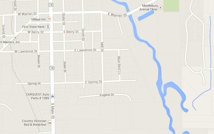
1 JUNE 014 OUTING LITTLE ELKHART RIVER Date: JUNE,014 Where: Little Elkart River in Middleburry, IN Lunch at 1:30 at River Bend Park Pavilion, Middlebury, IN. We will be grilling out the club will furnish the meat. Bring a dish (optional), chair and something to drink. Come join us for fun and fellowship as we fish the Little Elkhart River. The Little Elkhart is a small, beautiful Northern Indiana stream. The stream rises in southern LaGrange County and flows in a northwesterly direction through cropland, deep woods, pastures, parks and residential backyards before entering the St. Joseph River at Bristol. Trout are found throughout its length. Various sections offer different types of water. The headwaters are narrow and shallow. Downstream is deeper and broader. Yet, it is a fragile stream for trout. LECTU President Mike Beachy has offered to make himself available to meet up and answer questions when people arrive at the park Catch and Release Access Points LECTU installing catch and release signs There are several access points to the Little Elkhart River. The outing will focus mainly on the access points within the catch and release area. This is a mile section of the Little Elkhart that runs from the bridge on country road 43 to the foot bridge just upstream from Riverbend Park. This entire section can be waded as long as you stay in the water or along the shore. The main access points will be within this area. Please refer to the map on the last page. LECTU installed several signs indicating the catch and release section of the Little Elkhart River. In this area you can not possess any trout or natural bait. Only artificial lures and artificial flies can be used in this area. All other parts of the river have a five trout limit however only one may be a brown trout. 1 3 County Road 43 Bridge The catch and release area starts here and goes for the next two miles down-stream. Fishing can be done either upstream to Hwy 0 or downstream. Home-owner permission is not needed as LECTU has made agreements with the land owners. Rowe-Eden Ditch is just downstream from the bridge and can also hold fish. Rowe-Eden typically runs 5 degrees cooler than the Little Elkhart. Vehicles can be parked alongside the road. Spring Street Spring Street ends in a cul-de-sac. There is a trail that leads back to the river. Fishing can be done upstream or down. This access point is in the middle of the lower half of the catch and release area. By sticking to the edge of the river, fishing can be done all the way upstream to CR 43. Riverbend Park Riverbend Park has both plenty of parking and easy access to the river. Fishing can be done both upstream or down. There is a trail system that runs upstream from the edge of the park. The trail leads to the foot bridge that marks the lower boundary.

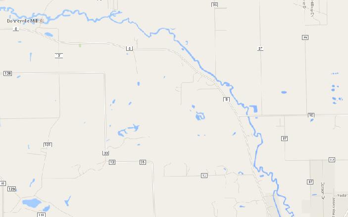
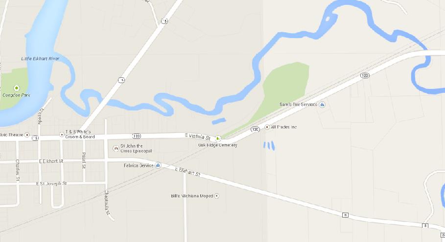
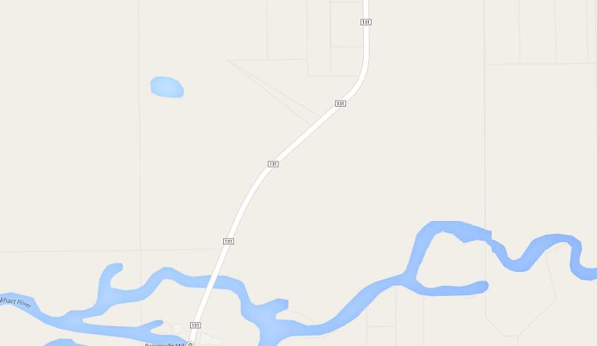
2 Other Access Points 4 CR35 Upstream is very good. This is like a classic trout stream. Can wade upstream all the way to the next bridge. Only about 3/4 mile or so of this stretch is good trout fishing. After that, it flattens out but becomes a good bass fishery. Wading can be done downstream all the way to Bonneyville Mill Park, but fishing downstream is a little tougher. Parking can be done on both sides of the bridge. 5 Bonneyville Mill Park There is plenty of parking at the Kim Mol Rie shelter area, and a trail leads down to the river. Trails along the river offer easy access. It can get deep in this area. Fishing can be done upstream or down. Wade upstream all the way to Eby Pines campground. There is a really nice area behind Eby Pines, but they will charge to drive back there. Bristol Area There are several access points in Bristol. There is a public access launch site to the St. Joseph river at the mouth of the Little Elkhart. A second spot is near the Little Elkhart River bridge on Hwy 10 east of Bristol. This section of the river has lots of rocky riffles, but also some very deep holes. So be careful when fishing this section. Little Elkhart River Conservation Lunker Structures The trail upstream from Riverbend Park leads past the lunker structures that were added to the river last year. These structures are like large pallets, 4 feet wide by 8 feet long and about feet tall. The river bank was dug out and these structures were anchored in place and then covered with rock and back-filled. These structures give the fish a place out of the main current to use as ambush points. Look for the riprap on the outside bend along the trail.

3 Access Points Maps 3 1 Catch and release area is highlighted in green
4 3 5 4
5 5
Thanks to Burt Strom, Dick Pearce, and Ed Lombardo, Sr. for their help and information.
 The upper section of the Wood River that runs approximately two miles downstream from the bridge on State Route 165 contains a number of significant pools. Although the river is constantly changing through
Highland Region MAP. No. 11 St. Marys River No. 12 West River No. 13 Wallace River No. 14 Toney River No. 15 Northumberland Strait
 Highland Region MAP No. 11 St. Marys River No. 12 West River No. 13 Wallace River No. 14 Toney River No. 15 Northumberland Strait 14 Route: No. 11 St. Marys River Rating: Intermediate Advanced Length:
Patuxent River Fishing Guide Trout Special Regulations Area, Near Damascus, MD
 Patuxent River Fishing Guide Trout Special Regulations Area, Near Damascus, MD Last Updated: March 2017 The Basics The Patuxent River near Damascus, Maryland is about 12 miles of Catch and Release water.
Crawford Reservoir. FISH SURVEY AND MANAGEMENT INFORMATION Eric Gardunio, Fish Biologist Montrose Service Center
 FISH SURVEY AND MANAGEMENT INFORMATION General Information: Crawford Reservoir is a popular fishery that provides angling opportunity for yellow perch, channel catfish, northern pike, rainbow trout, black
Fly Fisher s Quick Reference Guide to the Gunnison Valley
 Fly Fisher s Quick Reference Guide to the Gunnison Valley By John Bocchino Fly Fisher s Quick Reference Guide to the Gunnison Valley By John Bocchino Copyright 2015 John Bocchino All Rights Reserved. John
Penns Creek, Section 05 Fishery Update and Regulation Review
 Penns Creek, Section 05 Fishery Update and Regulation Review Mission: To protect, conserve, and enhance the Commonwealth s aquatic resources and provide fishing and boating opportunities 66-mile long tributary
Cross Country Skiing in the Tumbler Ridge Area
 Cross Country Skiing in the Tumbler Ridge Area There are numerous locations that are great for cross country skiing in the area surrounding Tumbler Ridge. Some are on trails that have hiking brochures
2018 Sport Fishing Regulations Exhibit B
 2018 Sport Fishing Regulations Exhibit B Mike Gauvin -Recreational Fisheries Program Manager Commission Rulemaking August 4 th 2017 1 Topics for Consideration Public involvement in 2018 regulation process
ES1 - Rivers, Creeks and Streams
 Legend: = Default regulations for Fish Management Zone ES1. As examples 3 over 63 indicates a possession and a size limit and 3 or 10 indicates a possession limit for that species of any size. Watershed
Canoe Route. Dogtooth Lake-Highwind Lake-Dryberry Lake- Lake of the Woods-Blindfold Lake
 1 Canoe Route Dogtooth Lake-Highwind Lake-Dryberry Lake- Lake of the Woods-Blindfold Lake This is an interesting and challenging route starting and ending at Rushing River Provincial Park. It passes over
Fly Fishing Etiquette
 Fly Fishing A basic outline of etiquette rules to help the wade & float fishing angler Provided by the Colorado Cutthroat Chapter of Trout Unlimited Www.cutthroatctu.org Compiled and Edited by: Kent Higgins
Lake Seminole. and Waters Bordering Georgia and Alabama
 Lake Seminole and Waters Bordering Georgia and Alabama LAKE SEMINOLE Site Description Lake Seminole is a 37,500-acre reservoir located at the juncture of the Florida, Georgia, and Alabama state lines.
Dallas District Men s Retreat Fishing Tournament Rules and Regulations
 Dallas District Men s Retreat Fishing Tournament Rules and Regulations Date: Friday and Saturday, September 19 & 20 Location: Caddo Lake See map for public boat launch locations Entry Fee: $25 per person/$40
Detailed maps, and portaging and camping information follow.
 Overview of Bain route. The launch site is at Davidson Lake, just before the Manitoba/Ontario border. You can do a loop if you leave a vehicle at Tulabi Lake (at the canoe route parking lot). The road
Earthen Paradise Field Trip Report by Dave Lines
 Earthen Paradise Field Trip Report by Dave Lines Visions of beautiful blue kyanite crystals danced in our heads as five members and one guest of our Southern Maryland Rock and Mineral Club converged on
Norwalk River. Ridgefield, Redding, Wilton & Norwalk
 FLY FISHING FAIRFIELD COUNTY Norwalk River Ridgefield, Redding, Wilton & Norwalk Fast Facts Length: 24 miles Width: 10-20 feet Depth: 2-3 feet Access: Excellent - Many town parks and open spaces Stocking:
Mending Lines. Rex's Reelings UPCOMING EVENTS. January March, Page 1
 Three Rivers Fly Fishers LLC Mending Lines January March, 2015 Page 1 UPCOMING EVENTS 2015 February 19 Club Meeting Mike Beachy Little Elkhart Trout Classic Cafe 7:00 PM March 4 Board Meeting New Haven
Fishing Forecast White Mountains. Fishing Rating: Hot Good Fair Poor. Clear Creek Reservoir -- Rating:
 Fishing Forecast White Mountains Fishing Rating: Hot Good Fair Poor Clear Creek Reservoir -- Rating: As winter weather cools water temperatures, warmwater species like largemouth bass, sunfish, catfish
6TH PELLETIER BROOK LAKE T15 R9, Aroostook Co. U.S.G.S. Gardner Pond, Maine (7 1/2 )
") 6TH PELLETIER BROOK LAKE T15 R9, Aroostook Co. U.S.G.S. Gardner Pond, Maine (7 1/2 ) Fishes Brook trout Minnows Blacknose dace Pearl dace Physical Characteristics Area - 27 acres Average depth - 2 feet
6TH PELLETIER BROOK LAKE T15 R9, Aroostook Co. U.S.G.S. Gardner Pond, Maine (7 1/2 ) Fishes Brook trout Minnows Blacknose dace Pearl dace Physical Characteristics Area - 27 acres Average depth - 2 feet
Tahquamenon River Assessment
 State owned land USFS land Superior Lower Falls USGS Gauging Station Superior Tahquamenon s Belle s Slater s Bass Betty B Dollarville Flooding Eckerman McMillan Mud East Kaks Twin McPhee s Hulbert Hulbert
Henrys Fork - Railroad Ranch
 Henrys Fork - Railroad Ranch Location: Henry's Fork River runs approximately 127 miles from Henry's Lake (N44.59711 W111.35330) to its confluence with the Snake River (N43.75267 W111.95776). The area is
INDIANA REGIONAL GENERAL CONDITIONS FOR THE STATE OF INDIANA
 INDIANA REGIONAL GENERAL CONDITIONS FOR THE STATE OF INDIANA These regional conditions are in addition to but do not supersede the requirements in the Federal Register (Volume 82 No. 4 of January 6, 2017).
Lakes up Lake Creek drainage in the White Knob Mountains: Golden (Golden), Big (Cut, RB), Rough (Cut, RB), Long (RB), Round (Grayling).
, Big (Cut, RB), Rough (Cut, RB), Long (RB), Round (Grayling).") Date Early September Time All Day Location Copper Basin Area; Sun Valley, ID Weather Clear Fish Species Golden, Cutthroat, RB, Grayling Size Range 10 16 Fish Caught Several Golden & Cutthroat Flies Used
Date Early September Time All Day Location Copper Basin Area; Sun Valley, ID Weather Clear Fish Species Golden, Cutthroat, RB, Grayling Size Range 10 16 Fish Caught Several Golden & Cutthroat Flies Used
The Lake at Durham County Wildlife Club and Its Recreational Uses
 The Lake at Durham County Wildlife Club and Its Recreational Uses The lake at DCWC affords many enjoyable recreational opportunities to club members, their families, and friends. Fishing and boating are
Fall Fishing in the White Mountains By Diane Tilton, AZGFD
 Fall Fishing in the White Mountains By Diane Tilton, AZGFD With the leaves beginning to change colors and a noticeable crispness to the air, fall is almost upon us in the White Mountains. With the cooler
Androscoggin River Trail Access Sites. Mahoosucs. 168 miles from its source at Lake Umbagog to Merrymeeting Bay
 Androscoggin River Trail Access Sites Mahoosucs 168 miles from its source at Lake Umbagog to Merrymeeting Bay Trail Under Construction More than 40 Public Access Sites Available Androscoggin River Watershed
Fly Fishing for Trout in Southeast Minnesota Streams
 Fly Fishing for Trout in Southeast Minnesota Streams Fly Fishing for the First Time? Equipment Basics Mid-weight fly rod, 5 or 6 weight, with fly line to match Reel Leader Extra tippet Flies Glasses or
Lake Rotorua and Tributaries
 Lake Rotorua and Tributaries EASTERN R EGION Lake Rotorua & tributaries Trout fishing on Lake Rotorua and its tributary streams is considered world-class. There are few places with trout fishing of such
Contents... Page 2. Page. Introduction & About the Hotel 3. Loch Fishing, Boats, Ghillies, our Self help and Conservation Philosophy 4
 Page 1. Page Contents... Introduction & About the Hotel 3 Loch Fishing, Boats, Ghillies, our Self help and Conservation Philosophy 4 Overview map of nearest Lochs to the Hotel 5 Loch Craggie 6 Loch Eileag
River-Lab Grade 3 (RL3) Route Green & Yellow Deep River Pool Trail Guide
 Route Green & Yellow Deep River Pool Trail Guide") River-Lab Grade 3 (RL3) Route Green & Yellow Deep River Pool Trail Guide Route Green & Yellow Deep River Pool Trail Route Sequence Deep Pool Habitat Observation Marsh Habitat Observation Riffles Habitat
River-Lab Grade 3 (RL3) Route Green & Yellow Deep River Pool Trail Guide Route Green & Yellow Deep River Pool Trail Route Sequence Deep Pool Habitat Observation Marsh Habitat Observation Riffles Habitat
Mogollon Rim and White Mountains Angler Report
 Mogollon Rim and White Mountains Angler Report Becker Lake, Monday, Nov. 6 Blain O.: Becker Lake fished well last week though the water was cold (50- degrees F at the surface). Fish were scattered everywhere
Canoe Trip # Length of Trip: 225 kilometres Time Required to Complete Trip: 10 to 14 days Number of Portages: 21 to 25
 Canoe Trip #34 34 Brabant Lake - Wapiskau River - Steephill Lake - Reindeer River - Churchill River - Sandy Bay 225 Kilometers - 10 to 14 days - 21 to 25 portages Length of Trip: 225 kilometres Time Required
SALINAS VALLEY FLY FISHERS TIMES
 SALINAS VALLEY FLY FISHERS July 2017 FLY TIMES Inside this issue: President s message 1 Fly of the Month 2 Monthly Program 3 Outing Schedule 3 Featured Stream 4 Maps 5 Events 6 2017 Board Members Richard
Welcome to Northern Vermont Introduction 11 Geography and Geology 14 Natural History 19 Northern Vermont History 27 General Topics 29
 Welcome to Northern Vermont Introduction 11 Geography and Geology 14 Natural History 19 Northern Vermont History 27 General Topics 29 Parking and Access 29 Customs 29 Water Regime and Prediction 31 Water
CRYSTAL LAKES ROAD AND RECREATION ASSOCIATION FISHING POLICY. October 17, 2015
 CRYSTAL LAKES ROAD AND RECREATION ASSOCIATION FISHING POLICY 1. SCOPE 1.1. ALL anglers are required to visibly wear fishing badges at all times while fishing. Members must visibly wear their CLRRA photo
Canoe Trip # Maps: 63L Amisk Lake 63M Pelican Narrows
 Canoe Trip #51 49 Southeast Arem Deschambault Lake - Pelican Narrows - Wunehikun Bay - Attitti Lake - Belcher Lake - Mukoman Lake - Ohoo Lake - Mukoman River - Sokatisewin Lake - Sandy Bay 170 Kilometers
ES1 - Lakes, Reservoirs and Ponds
 Legend: = Default regulations for Fish Management Zone ES1. As examples 3 over 63 indicates a possession and a size limit and 3 or 10 indicates a possession limit for that species of any size. An empty
Launch A: Experimental Lakes Road The launch site is about 4 km from highway #17. There is a sign on the highway indicating the experimental lakes
 Launch A: Experimental Lakes Road The launch site is about 4 km from highway #17. There is a sign on the highway indicating the experimental lakes road. You have to cross railway tracks on the way to the
CHECK OUT OUR WEBSITE FOR SPONSOR/PARTNERS & MORE INFO Blue Ridge Mountain Trout Unlimited UP THE CREEK DEC 2017
 UP THE CREEK DEC 2017 Blue Ridge Mountain Trout Unlimited Chapter 696 Meets the second Saturday of the month at 9 am at Faith Presbyterian Church 56 Mountain Street Blue Ridge, GA 30513 CHECK OUT OUR WEBSITE
Claytor Lake View of the Claytor Lake dam from Claytor Lake State Park s boat ramp.
 Claytor Lake 2007 Imagine yourself on a waterbody that is more like a wide river than a lake. When you do, you will have a picture of Claytor Lake. Claytor Lake, a 4,475-acre reservoir, stretches northeastward
KYLE OF SUTHERLAND ANGLING ASSOCIATION.
 KYLE OF SUTHERLAND ANGLING ASSOCIATION. VIRTUAL GHILLIE SALMON The Kyle of Sutherland offers some of the finest Salmon estuary fishing in the country. when the weather is dry, and the rivers are low, salmon
Sport fishing in Québec (including salmon fishing) - April 1, 2017 to March 31, 2018 Fishing periods, catch limits and exceptions - Zone 21
 - April 1, 2017 to March 31, 2018 Fishing periods, catch limits and exceptions - Zone 21") Sport fishing in Québec (including salmon fishing) - April 1, to March 31, periods, The Zone Rules table sets out the fishing periods and daily catch limits for fish species of interest to sport fishers
Sport fishing in Québec (including salmon fishing) - April 1, to March 31, periods, The Zone Rules table sets out the fishing periods and daily catch limits for fish species of interest to sport fishers
Summer Steelhead Surveys North Fork Trinity River Trinity County, California
 KRIS edition Summer Steelhead Surveys North Fork Trinity River Trinity County, California 1978-1997 By Loren Everest Fishery Biologist Weaverville Ranger District Shasta-Trinity National Forests October
FINAL REPORT. Yonkers Creek Migration Barrier Removal Project Wonderstump Road Del Norte County. Submitted By:
 FINAL REPORT Yonkers Creek Migration Barrier Removal Project Wonderstump Road Del Norte County Submitted By: Del Norte County Community Development Department Yonkers Creek Migration Barrier Removal Project
Public Notice. Corps File No. LRE Date: March 19, 2017 Expires: March 18, 2022
 US Army Corps of Engineers Detroit District Public Notice Corps File No. LRE-2016-00006-100 Date: March 19, 2017 Expires: March 18, 2022 PUBLIC NOTICE ANNOUNCING REGIONAL CONDITIONS AND WATER QUALITY CERTIFICATIONS
Fish Texas AQUATIC ECOSYSTEMS
 27 Additionally, healthy aquatic communities in Texas rivers, reservoirs and estuaries provide unparalleled recreational opportunities to millions of Texans. Our fresh and saltwater environments vary from
Electrofishing Surveys Shed Light on Dynamic Millstone River Fishery. By Shawn Crouse, Principal Fisheries Biologist
 Electrofishing Surveys Shed Light on Dynamic Millstone River Fishery By Shawn Crouse, Principal Fisheries Biologist It is June, 2018 and American Shad have been on the move! Great efforts are being made
Androscoggin River Trail Access Sites. Mahoosucs. 168 miles from its source at Lake Umbagog to Merrymeeting Bay
 Androscoggin River Trail Access Sites Mahoosucs 168 miles from its source at Lake Umbagog to Merrymeeting Bay Trail Under Construction More than 40 Public Access Sites Available Androscoggin River Watershed
River ride exposes Reno s scenic side, also her flaws
 River ride exposes Reno s scenic side, also her flaws Benjamin Spillman, bspillman@rgj.com 5:34 p.m. PDT June 21, 2016 Buy Photo The Truckee River from Reno to USA Parkway represents a confluence of nature
NWS 44: Mining Activities Location #1, Stanislaus River
 NWS 44: Mining Activities Location #1, Stanislaus River Permit is for the use of a single 8 dredge on a federal mining claim at the location described on the map and as Twp 02N Range 14E, Section 04, MDM
Fraser River. FISH SURVEY AND MANAGEMENT INFORMATION Jon Ewert - Aquatic Biologist (Hot Sulphur Springs)
") Fraser River FISH SURVEY AND MANAGEMENT INFORMATION Jon Ewert - Aquatic Biologist (Hot Sulphur Springs) General Information: The Fraser River is a highly diverse river offering many transitions in habitat
Fraser River FISH SURVEY AND MANAGEMENT INFORMATION Jon Ewert - Aquatic Biologist (Hot Sulphur Springs) General Information: The Fraser River is a highly diverse river offering many transitions in habitat
Lower Dolores River Corridor Planning Meeting Jim White Colorado Division of Wildlife
 Lower Dolores River Corridor Planning Meeting Jim White Colorado Division of Wildlife Objectives Overview of cold and warm water fishes in the Dolores River including: Flow and Fish Management Distribution
REGULATIONS. Special Areas. Black Bass HANDLING AND RELEASE PROCEDURES. Catch-and-Release. Minimum Size Limit. Slot Limit. For waters listed below
 Special Areas REGULATIONS Black Bass 1. All black bass (smallmouth, spotted and largemouth) caught must be returned to 2. No black bass shall be in the angler s possession (creel limit 0) while fishing
Anglers Notice for Taupō District
 Anglers tice for Taupō District (as amended) Conservation Act 1987 Taupō Fishery Regulations 2004 Pursuant to sections 26R(3) and 53(4) of the Conservation Act 1987, the Minister of Conservation approves
- Your Guide to Flounder Fishing -
 Contents - Your Guide to Flounder Fishing -... 2 Flounder Rigs.... 3 Flounder Fishing Bait.... 4 Where to Target Flounder... 5 When to Target Flounder... 6 Lure fishing for Flounder... 7 Flounder fishing
Fishing Forecast White Mountains
 Fishing Forecast White Mountains Fishing Rating: Hot Good Fair Poor Clear Creek Reservoir - Rating: Rainbow trout stocked in spring should be fished out by now. Instead, target warmwater species like largemouth
Under and Over Cliff Walk
 Under and Over Cliff Walk 4 hrs 9.4 km Circuit Moderate track 576m This walk from Wentworth Falls Station is a fantastic way to see a large majority of the Wentworth Falls cliffline. The track winds under
Module 8 River and Stream Fishing
 Module 8 River and Stream Fishing What is River and Stream Fishing? It is trying to catch fish in a river or stream with a fly rod and flies. Why do you Fish Rivers and Streams. 1. Fish will give a better
All tournament participants are invited to the awards ceremony located near the weigh-in site at the Downtown Riverside RV Park Pavilion..
 Official Rules Petit Jean / 1037 The Buzz Fishing Tournament This tournament is for amateur anglers. If you consider yourself a professional fisherman, or if the majority or big portion of your annual
Introduction to Steering on the Tideway
 Introduction to Steering on the Tideway WARNING - This document is only an introduction All coaches, water safety advisors and coxes/steers who go out unsupervised must be familiar with the detail of the
Day 1 (Farley 7745, Bow Knot, Toxaway 8323)
") Date August 8 12, 2005 Time Location Sawtooths (Tin Cup Trailhead) Weather Scattered Clouds Fish Species Rainbow, Brook, Cutthroat Size Range Brook 6-11 Rainbow/Cutthroat 12-18 Fish Caught To many to count
Date August 8 12, 2005 Time Location Sawtooths (Tin Cup Trailhead) Weather Scattered Clouds Fish Species Rainbow, Brook, Cutthroat Size Range Brook 6-11 Rainbow/Cutthroat 12-18 Fish Caught To many to count
Lamar River. Exploring the Lamar
 Lamar River Location: The Lamar Valley is in the north east section of the Park south of the Northeast entrance and Cooke City, MT. The Lamar River is 40 miles long originating in the Absoraka Range (N44.68534
Walleye are caught on bottom bouncers with worms, on plastic baits retrieved close to the. May 30, Bluegill Prizes Awarded this Week.
 Lake Powell Fish Report May 30, 2018 Lake Elevation: 3611 Water temperature: 67-74 F By: Wayne Gustaveson http://www.wayneswords.com or Wayneswords.net Lake Powell continues to rise with inflow doubling
Statement of Purpose SAMPLE. About This Book
 Statement of Purpose The Challenge Chapter of Trout Unlimited is a non-profit organization dedicated to the restoration and preservation of cold water fisheries in the state of Michigan. Proceeds from
! " # $ % & % & ' ( ) * +
 * +") !" #$%& %& '() *+ EnVision Manistee County Fact Book Manistee County Community Foundation Spring 2005 Natural Environment & Recreation Page 1 Commercial Lodging Many of Manistee County s visitors choose
!" #$%& %& '() *+ EnVision Manistee County Fact Book Manistee County Community Foundation Spring 2005 Natural Environment & Recreation Page 1 Commercial Lodging Many of Manistee County s visitors choose
Thornton le Dale Walks
 Thornton le Dale Walks A collection of walks in and around the village Thornton le Dale Traders Forum www.visitthorntonledale.co.uk Thornton le Dale Walks Walk 1: Beck Isle Cottage and All Saints Church
CSF/Stonefly Maidens Central Oregon Cascades Fly-fishing Outing: Crane Prairie Campground See CSF Calendar for Official Dates
 CSF/Stonefly Maidens Central Oregon Cascades Fly-fishing Outing: Crane Prairie Campground See CSF Calendar for Official Dates CSF co-fish Masters Russ Flaskerud and Timothy Buckley This year treat Dad
MINISTRY OF ENVIRONMENT ENVIRONMENTAL STEWARDSHIP DIVISION FISH AND WILDLIFE BRANCH. Horsefly River Angling Management Plan
 MINISTRY OF ENVIRONMENT ENVIRONMENTAL STEWARDSHIP DIVISION FISH AND WILDLIFE BRANCH Horsefly River Angling Management Plan January 30 th, 2006 Area/Fishery Description The Horsefly River watershed provides
Nor East Chapter Trout Unlimited January 2013 Newsletter
 Nor East Chapter Trout Unlimited January 2013 Newsletter Happy New Year! With the first real snow of the season still on the ground, many of us have turned to indoor pursuits...diving into that new fly
STUDY PERFORMANCE REPORT
 STUDY PERFORMANCE REPORT State: Michigan Project No.: F-80-R-2 Study No.: 487 Title: Performance, survival and production of steelhead strains in tributaries of Lake Michigan and Lake Huron. Period Covered:
Searsville Dam Removal
 Searsville Dam Removal A unique opportunity for all Presented by the Beyond Searsville Dam Coalition San Francisquito Creek flows into the San Francisco Bay near the Palo Alto Airport and Golf Course seen
Trail and Driving Directions
 Trail and Driving Directions GETTING TO THE START: FROM CADILLAC: Follow M-55 west from US131 for 20.9 miles to the corner of M-37 and M-55 FROM THE INTERSECTION OF M-55 AND M-37: Head west on M-55 2.7
Bull Trout Population Study in the Middle Fork Willamette and McKenzie River Drainage Basins. June - November Stephen D. Hammond Giles C.
 Bull Trout Population Study in the Middle Fork Willamette and McKenzie River Drainage Basins June - November 1994 Stephen D. Hammond Giles C. Thelen Oregon Department of Fish and Wildlife 3150 East Main
Berowra to Mt Kuring-gai
 Berowra to Mt Kuring-gai 4 hrs 30 mins 9.4 km One way Hard track 4 551m From the ridges above Cowan Creek, this walk takes in some great lookouts (especially around Mt Kuringgai) as well as enjoying an
3 Spots You Need to Know to Catch More Steelhead. Take your game to the next level with these pro tips!
 3 Spots You Need to Know to Catch More Steelhead Take your game to the next level with these pro tips! One of the biggest keys to steelhead fishing success is being able to identify where the fish like
$123, /- Acres. Blount County, AL. Sean Brown Office: Cell: Fax:
 mulberry@fork river@runs through@it@tract 21 +/- Acres Blount County, AL $123,000 National Land Realty 9 N. Conception St. Mobile, AL 36602 www.nationalland.com Sean Brown Office: 855.657.5263 Cell: 205.531.9221
Wind Rock Ranch DUBOIS, WYOMING
 Wind Rock Ranch DUBOIS, WYOMING Wind Rock Ranch DUBOIS, WYOMING Introduction: The Wind Rock Ranch is located in Fremont County, Wyoming, six miles south-east of the town of Dubois, WY. The ranch headquarters
Job 4. Title: Evaluate performance of upstream and downstream plants.
 STUDY PERFORMANCE REPORT State: Michigan Project No.: F-80-R-4 Study No.: 487 Title: Performance, survival and production of steelhead strains in tributaries of Lake Michigan and Lake Huron. Period Covered:
DEPARTMENT OF WILDLIFE Fisheries Division 6980 Sierra Center Parkway, Ste 120 Reno, Nevada (775) Fax (775)
 Fax (775)") STATE OF NEVADA #23 DEPARTMENT OF WILDLIFE Fisheries Division 6980 Sierra Center Parkway, Ste 120 Reno, Nevada 89511 (775) 688-1500 Fax (775) 688-1987 MEMORANDUM September 24, 2016 To: From: Title: Nevada
STATE OF NEVADA #23 DEPARTMENT OF WILDLIFE Fisheries Division 6980 Sierra Center Parkway, Ste 120 Reno, Nevada 89511 (775) 688-1500 Fax (775) 688-1987 MEMORANDUM September 24, 2016 To: From: Title: Nevada
Wentworth Falls Station Loop (Undercliff Walk)
") Wentworth Falls Station Loop (Undercliff Walk) 4 hrs 3 mins Hard track 8.9 km Circuit 658m 4 This walk passes some stunning waterfalls and views into the Jamison Valley, following the cliff edges around
Wentworth Falls Station Loop (Undercliff Walk) 4 hrs 3 mins Hard track 8.9 km Circuit 658m 4 This walk passes some stunning waterfalls and views into the Jamison Valley, following the cliff edges around
Columbia River Fishery Notice
 Columbia River Fishery Notice Oregon Department of Fish and Wildlife January 29, 2014 Compact Action The Columbia River Compact agencies of Oregon and Washington met today and took the following actions:
North Idaho River Trips
 North Idaho River Trips Campus Recreation 875 Perimeter Drive MS 1230 Moscow. Idaho 83844-1230 Ph: 208.885.6810 Rentals: 208.885.6170 Fax: 208.885.6879 uidaho.edu/outdoorprogram 1 NORTH IDAHO RIVER TRIPS
Mileage One-Way (Remember, river left is the left side of the river headed downstream.)
") Santa Fe River Fact Sheet www.5-staryakpak.org Mileage One-Way (Remember, river left is the left side of the river headed downstream.) Mileage Chart 0.0 Santa Fe Rise (N29.87388 W82.59158) 2.4 Darby Spring,
Santa Fe River Fact Sheet www.5-staryakpak.org Mileage One-Way (Remember, river left is the left side of the river headed downstream.) Mileage Chart 0.0 Santa Fe Rise (N29.87388 W82.59158) 2.4 Darby Spring,
Mending Lines. Don s Den
 T hr ee River s F ly F isher s LL C Mending Lines October December, 2016 Page 1 UPCOMING EVENTS October 5 Board Meeting Kaysan s 5th Down 6:45 PM October 20, 2016 Club Meeting Dan Wire, Tri State Watershed
Gamefish Assessment Report
 MINNESOTA DEPARTMENT OF NATURAL RESOURCES Gamefish Assessment Report Spring Gamefish Assessment on the Mississippi River from Little Falls to Brainerd, MN May 31 through June 4, 2013 River Miles 966 to
62. Gulkana River, Main Fork, Middle Fork, and West Fork
 62. Gulkana River, Main Fork, Middle Fork, and West Fork The Gulkana, a National Wild and Scenic River, is one of Alaska s most popular whitewater rivers because of its road accessibility and because of
Flaming Gorge Angler s Guide
 Flaming Gorge Angler s Guide The most scenic trophy trout destination in the world Ogden Standard Examiner Flaming Gorge Country is one of the premier fishing destinations in the United States. We not
2012 No. 458 FISHERIES. The Foyle Area and Carlingford Area (Angling) (Amendment) Regulations 2012
 (Amendment) Regulations 2012") STATUTORY RULES OF NORTHERN IRELAND 2012 No. 458 FISHERIES The Foyle Area and Carlingford Area (Angling) (Amendment) Regulations 2012 Made - - - - 12th December 2012 Coming into operation - 31st January
STATUTORY RULES OF NORTHERN IRELAND 2012 No. 458 FISHERIES The Foyle Area and Carlingford Area (Angling) (Amendment) Regulations 2012 Made - - - - 12th December 2012 Coming into operation - 31st January
Fisheries Management Zone 10:
 Fisheries Management Zone 10: Lake Trout Operational Objectives and Management Photo Credit: www.jamessmedleyoutdoors.com 2 FMZ 10: Lake Trout Operational Objectives and Management Lake trout are the second
Identifying and Executing Stream Projects Kristin Thomas, Aquatic Ecologist MITU
 Identifying and Executing Stream Projects Kristin Thomas, Aquatic Ecologist MITU Introduction 1. Methods for Identifying Projects 2. Methods in Action 3. The Partnership Paradigm 2 River Stewards Program
Fishing for Yellows on the Riet River. By Andrew Mather
 Fishing for Yellows on the Riet River By Andrew Mather The Riet River Part 1. We arrived early on Monday morning at the Lilydale Rest Camp in the Motala Nature Reserve, just south of Kimberley. This piece
Klamath River Fishing
 Klamath River Fishing Come and experience one of the best salmon and steelhead fishing trips we have to offer. The mouth of the Klamath River. Join us as we take a scenic jet boat ride up river to our
The Economic Importance of Recreational River Use to the City of Calgary
 The Economic Importance of Recreational River Use to the City of Calgary Prepared by: Calgary River Users Alliance May 20, 2016 The Economic Importance of Recreational River Use to the City of Calgary
Using This Guide. Latitude and longitude lines are indicated in white (see next page for complete legend).
.") Using This Guide This guide is divided into 13 sections. Each section is approximately 5 miles long. The detailed maps contain mileage figures and GPS points. Distances on the map are approximate. Your
Using This Guide This guide is divided into 13 sections. Each section is approximately 5 miles long. The detailed maps contain mileage figures and GPS points. Distances on the map are approximate. Your
Wentworth Falls Conservation Hut Loop
 Wentworth Falls Conservation Hut Loop 3 hrs Hard track 6.7 km Circuit 4 341m This scenic walk from Wentworth Falls Station, winds along the Nature Trail to Conservation Hut, then drops into the magnificent
With Unmatched Amenities
 A Planned Gated Residential and Commercial Development In Manvel, Texas With Unmatched Amenities Developed by Joe Watson AXIS POINT DEVELOPERS, LLC Investment Builders and Developers 281 932 4143 JWatson@APDllc.net
INTRODUCTION TO STRUCTURE FISHING: IDENTIFICATION OF FISH LOCATIONS STRUCTURE FISHING
 INTRODUCTION TO STRUCTURE FISHING: IDENTIFICATION OF FISH LOCATIONS Featuring: - Migration Theory of fish. - Structure types: Point Bar Underwater Hump Channel Man Made - Understanding Breaks & Breaklines
Crook Ranch. Tehama County, California. Proudly Offered By
 Crook Ranch Tehama County, California Proudly Offered By 707 Merchant Street, Suite 100, Vacaville, Ca 95688 (707) 455-4444 Office (707) 455-0455 Fax info@caoutdoorproperties.com www.californiaoutdoorproperties.com
LAKE TANEYCOMO ANGLER CREEL SURVEY SUMMARY. Shane Bush Fisheries Management Biologist Missouri Department of Conservation Southwest Region
 LAKE TANEYCOMO 2008-2009 ANGLER CREEL SURVEY SUMMARY Shane Bush Fisheries Management Biologist Missouri Department of Conservation Southwest Region February 1, 2013 Introduction Lake Taneycomo was formed
Assessment of Elizabeth Lake as a Potential Candidate for Stocking
 Assessment of Elizabeth Lake as a Potential Candidate for Stocking Region 1, Nanaimo West Coast Planning Unit Ministry of Water, Land and Air Protection Prepared by: Laura Cassin Scott Silvestri 2002 1.0