ST. TAMMANY PARISH COUNCIL ORDINANCE
|
|
|
- Mavis Wiggins
- 5 years ago
- Views:
Transcription
1 ST. TAMMANY PARISH COUNCIL ORDINANCE ORDINANCE CALENDAR NO: 4748 COUNCIL SPONSOR: GOULD/BRISTER INTRODUCED BY: MR. STEFANCIK ORDINANCE COUNCIL SERIES NO: PROVIDED BY: PLANNING SECONDED BY: MR. ARTIGUE ON THE 5 DAY OF APRIL, 2012 ORDINANCE AMENDING THE OFFICIAL ZONING MAP OF ST. TAMMANY PARISH, LA, TO RECLASSIFY CERTAIN PARCELS LOCATED ON THE NORTH & SOUTH SIDES OF SLOAT ROAD, EAST OF VINCENT ROAD AND WHICH PROPERTY COMPRISES A TOTAL ACRES OF LAND MORE OR LESS, FROM ITS PRESENT A-3 (SUBURBAN DISTRICT) TO I-3 (HEAVY INDUSTRIAL DISTRICT-2.95 ACRES), I-2 (INDUSTRIAL DISTRICT- 6.5 ACRES), HC-1 (HIGHWAY COMMERICAL DISTRICT ACRES) AND A-3 (SUBURBAN DISTRICT ACRES) (WARD 9, DISTRICT 12). (ZC ) Whereas, the Zoning Commission of the Parish of St. Tammany after hearing in accordance with law, Case No. ZC , has recommended to the Council of the Parish of St. Tammany, Louisiana, that the zoning classification of the above referenced area be changed from its present A-3 (Suburban District) to I-3 (Heavy Industrial District-2.95 acres), I-2 (Industrial District- 6.5 acres), HC-1 (Highway Commerical District acres) and A-3 (Suburban District acres) see Exhibit A for complete boundaries; and Whereas, the St. Tammany Parish Council has held its public hearing in accordance with law; and Whereas, the St. Tammany Parish Council has found it necessary for the purpose of protecting the public health, safety and general welfare, to designate the above described property as I-3 (Heavy Industrial District-2.95 acres), I-2 (Industrial District- 6.5 acres), HC-1 (Highway Commerical District acres) and A-3 (Suburban District acres). THE PARISH OF ST. TAMMANY HEREBY ORDAINS, in regular session convened that: SECTION I: The zoning classification of the above described property is hereby changed from its present A-3 (Suburban District) to I-3 (Heavy Industrial District-2.95 acres), I-2 (Industrial District- 6.5 acres), HC-1 (Highway Commercial District acres) and A-3 (Suburban District acres). SECTION II: The official zoning map of the Parish of St. Tammany shall be and is hereby amended to incorporate the zoning reclassification specified in Section I hereof. REPEAL: All ordinances or parts of Ordinances in conflict herewith are hereby repealed. SEVERABILITY: If any provision of this Ordinance shall be held to be invalid, such invalidity shall not affect other provisions herein which can be given effect without the invalid provision and to this end the provisions of this Ordinance are hereby declared to be severable. EFFECTIVE DATE: This Ordinance shall become effective fifteen (15) days after adoption. MOVED FOR ADOPTION BY: SECONDED BY: WHEREUPON THIS ORDINANCE WAS SUBMITTED TO A VOTE AND RESULTED IN THE FOLLOWING:
2 YEAS: NAYS: ABSTAIN: ABSENT: THIS ORDINANCE WAS DECLARED DULY ADOPTED AT A REGULAR MEETING OF THE PARISH COUNCIL ON THE 3 DAY OF MAY, 2012 ; AND BECOMES ORDINANCE COUNCIL SERIES NO. ATTEST: MARTIN W. GOULD, JR., COUNCIL CHAIRMAN THERESA L. FORD, COUNCIL CLERK Published Introduction: March 29, 2012 Published Adoption:, 2012 PATRICIA P. BRISTER, PARISH PRESIDENT Delivered to Parish President: Returned to Council Clerk:, 2012 at, 2012 at
 A certain parcel of land lying and situated in Section 9, Township 9 South, Ranqe 14 East, Saint Tammany Parish, Louisiana and more fully described as follows.")
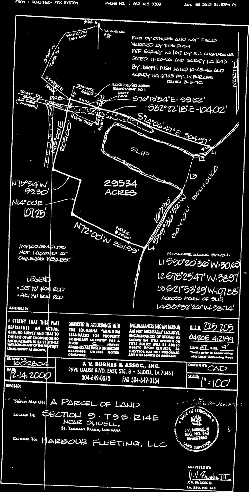
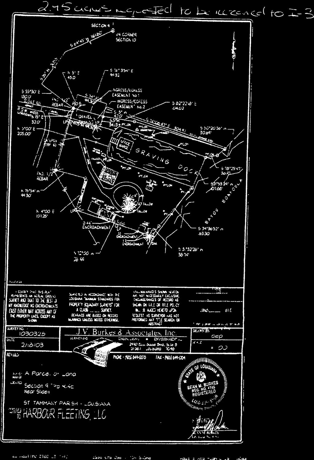
3 Exhibit A ZCI (Ileavy 1!ldnstrat DiMrkt-2.95 acres) A certain parcel of land lying and situated in Section 9, Township 9 South, Ranqe 14 East, Saint Tammany Parish, Louisiana and more fully described as follows. Commence from the Quarter Section corner common to Sections 9 & 10, Township 9 South, Range 14 East, Saint Tammany Parish, Louisiana run South 64 Degrees 45 Minutes West a distance of feet to a point; Thence run South 35 Degrees West a distance of feet to a point; Thence run South 55 Degrees 30 Minutes East a distance of feet to a 34 iron rod found and the Point of Beginning. From the Point of Beginning run South 76 Degrees 13 Minutes 54 Seconds East a distance of feet to a point; Thence run South 82 Degrees 22 Minutes 18 Seconds East a distance of feet to a point; Thence run South 74 Degrees 06 Minutes 47 Seconds East a distance of feet to a point on the right descending bank of Bayou Bonfouca; Thence follow said right descending bank of Bayou Bonfouca the following calls; South 50 Degrees 20 Minutes 36 Seconds West a distance of feet; South 78 Degrees 25 Minutes 47 Seconds West a distance of feet; South 21 Degrees 53 Minutes 29 Seconds West a distance of feet; South 39 Degrees 36 Minutes 52 Seconds West a distance of feet; South 31 Degrees 32 Minutes 26 Seconds West a distance of feet to a point; Thence leaving said right descending bank of Bayou Bonfouca run North 72 Degrees 00 Minutes West a distance of feet to a point; Thence run North 14 Degrees 00 Minutes East a distance of feet to a poinl Thence run North 75 Degrees 54 Minutes West a distance of feet to a W iron rod found; Thence run North 15 Degrees 00 Minutes East a distance of feet and back to the Point of Beginning. Containing acres of land more or less, and situated in Section 9, Township 9 South, Range 14 East, Saint Tammariy Parish, Louisiana 1-2 (1ndiistrhI District) A certain parcel of land lying and situated in Section 9, Township 9 South, Range 14 East, Saint Tammany Parish, Louisiana and more fully described as follows. Commence from the Quarter Section corner common to Sections 9 & 10, Township 9 South, Range 14 East, Saint Tammany Parish, Louisiana run South 64 Degrees 45 Minutes West a distance of feet to a point; Thence run South 35 Degrees 00 Minutes 00 Seconds West a distance of feet to a point and the Point of Beginning. From the Point of Beginning run South 55 Degrees 30 Minutes 00 Seconds West a distance of feet to a point on the right descending bank of Bayou Bonfouca; Thence follow said right descending bank of Bayou Bonfouca the following calls; South 27 Degrees 39 Minutes 11 Seconds West a distance of feet to a point; South 23 Degrees 31 Minutes 34 Seconds West a distance of feet to a point; South 62 Degrees 49 Minutes 26 Seconds West a distance of feet, North 56 Degrees 41 Minutes 02 Seconds West a distance of feet; North 59 Degrees 48 Minutes 56 Seconds West a distance of fee1, North 62 Degrees 15 Minutes 54 Seconds West a distance of feet; South 56 Degrees 52 Minutes 09 Seconds West a distance of feet to a point; North 71 Degrees 39 Minutes 43 Seconds West a distance of feet; South 57 Degrees 47 Minutes 07 Seconds West a distance of feet; South 40 Degrees 16 Minutes 41 Seconds West a distance of feet; Thence leaving said right descending bank of Bayou Bonfouca run North 74 Degrees 06 Minutes 47 Seconds West a distance of feet to a point; Thence run North 82 Degrees 22 Minutes 18 Seconds West a distance of feet to a point; Thence run North 76 Degrees 13 Minutes 54 Seconds West a distance of feet to a point; Thence run North 55 Degrees 30 Minutes 00 Seconds West a distance of feet to a point; Thence run North 35 Degrees 00 Minutes 00 Seconds East a distance of feet and back to the Point of Beginning. Containing acres of land more or less, and situated in Section 9, Township 9 South, Range 14 East, Saint Tammany Parish, Louisiana
 A certain parcel of land lying and situated in Section 9, Township 9 South, Range 14 East, Saint Tammany Parish, Louisiana and more fully described as follows.")


4 EXHIBIT A ZC CONT D HC-1 (Highway Commercial -3.2 acres) A certain parcel of land lying and situated in Section 9, Township 9 South, Range 14 East, Saint Tammany Parish, Louisiana and more fully described as follows. Commence from the Quarter Section corner common to Sections 9 & 10, Township 9 South, Range 14 East, Saint Tammany Parish, Louisiana run South 64 Degrees 45 Minutes West a distance of feet to a point; Thence run South 35 Degrees 00 Minutes 00 Seconds West a distance of to a point and the Point of Beginning. From the Point of Beginning run South 55 Degrees 30 Minutes 00 Seconds East a distance of feet to a point on the right descending bank of Bayou Bonfouca; Thence follow said right descending bank of Bayou Bonfouca the following calls: South 60 Degrees 05 Minutes 48 Seconds West a distance of feet to a point; Thence run South 27 Degrees 39 Minutes 11 Seconds West a distance of 7.35feetto a point; Thence leaving said right descending bank of Bayou Bonfouca run North 55 Degrees 30 Minutes 00 Seconds West a distance of feet to a point; Thence run North 35 Degrees 00 Minutes 00 Seconds East a distance of feet and back to the Point of Beginning. Containing 3.2 acres of land more or less, and situated in Section 9, Township 9 South, Range 14 East, Saint Tammany Parish, Louisiana A-3 (Suburban District 1.6 acres) A certain parcel of land lying and situated in Section 9, Township 9 South, Range 14 East, Saint Tammany Parish, Louisiana and more fully described as follows. Commence from the Quarter Section corner common to Sections 9 & 10, Township 9 South, Range 14 East, Saint Tammany Parish, Louisiana run South 64 Degrees 45 Minutes West a distance of feet to a point and the Point of Beginning. From the Point of Beginning run South 55 Degrees 30 Minutes 00 Seconds East a distance of feet to a point on the right descending bank of Bayou Bonfouca; Thence run along said right descending bank of Bayou Bonfouca the following calls, South 58 Degrees 57 Minutes 56 Seconds West a distance of feet to a point; Thence run South 78 Degrees 19 Minutes 58 Seconds West a distance of feet to a point; Thence run South 60 Degrees 05 Minutes 48 Seconds West a distance of 2.55 feet to a point; Thence leaving said right descending bank of Bayou Bonfouca run North 55 Degrees 30 Minutes 00 Seconds West a distance of feet to a point, Thence run North 35 Degrees 00 Minutes 00 Seconds East a distance of feet and back to the Point of Beginning. Containing 1.6 acres of land more or less, and situated in Section 9, Township 9 South, Range 14 East, Saint Tammany Parish, Louisiana

, 1-2 (Industrial District 6.")
, A-3 (Suburban District 1.")
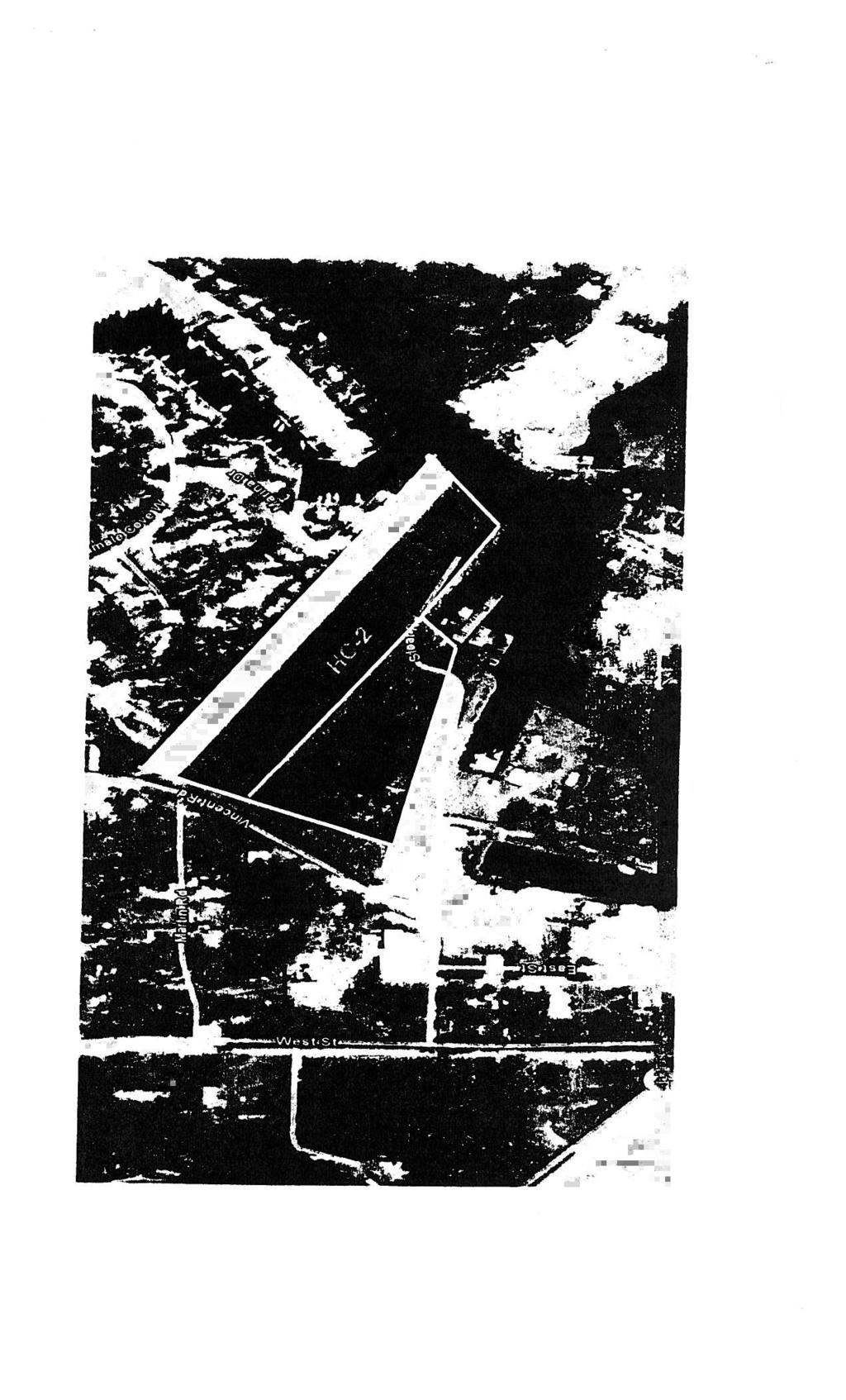
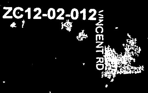
5 CASE NO.: REQUESTED CHANGE: LOCATION: SIZE: ZCI From A-3 (Suburban District) to 1-3 (Heavy Industrial District 2.95 acres), 1-2 (Industrial District 6.5 acres), HC-I (Highway Commercial District 3.2 acres), A-3 (Suburban District 1.6 acres) Parcels located on the north & south sides of Sloat Road, east of Vincent Road; S9,T9S,RI5E; Ward 9, District acres SLOAT RD AS
FEfl ZONE 1 S")
6 I 3Q.U. BAYOU BONFOUCA (h,:)c4fi::? -J C) NO1 NCUiOE S1.W ç NOTE: ACREAGE I 18oO± BAYOU FRONTAGE I41386± ACRES BU)FEfl ZONE 1 S /) iioao rrir - t.


7 February 9, 2012 Ms. Helen Lambert Assistant Director of Zoning St. Tammariy Parish,LA RE: Re-zoning of Harbor Fleeting LLC property to 1-3 (previously zoned M-2) Dear Mrs. Lambert, As per our conversation, I wanted to request that our shipyard property, located at Sloat Road, Slidell LA, which was zoned M-2 since 1985, and then re-zoned recently by the Parish (without our knowledge) to A3 be re-zoned back to 1-3, description of which is the closest to the original M-2 zoning. The property in question sits on 2.95 acres of land that surround a 260 by 100 foot graving dock with a cement foundation. It is designed for use for ship building and repair. We are requesting that our zoning be kept as 1-3, comparable to its original M-2 designation, going back to 1985, due to the reasons of history of our property, the use and zoning of the surrounding areas as well as existing legal agreements between us and St. Tammany Parish. HISTORY As you might be aware, our property has been used for commercial, marine and industrial purposes going back at least a hundred years. At the turn of the century it was a brick manufacturing yard and a shipyard for wooden schooners. Later it became a lumber yard which supplied lumber to New Orleans. In the s it was owned by Sloat Dredging Company and used as a barge slip and repair facility. At that time a 260 x 100 foot slip was added which could be closed off with sheet piles and the water pumped Out in order to convert it into a dry dock. During ] s Ingram Concrete Barge Company built the concrete barges for oil field production there. They added a very thick concrete slab to the bottom of the 260 x 100 ft slip for the purposes of making a foundation for concrete barge building. In the late 1980s and throughout 1990s the property was used for scrapping and repairing barges. And finally, in the last decade it was used for tugboat conversion and repair. SURROUNDING AREA The surrounding area is all industrial except for the subdivision to the northeast which is located 700 feet away. To the east, directly across the bayou is the Slidell Water Treatment facility. To their south are Omni Pinnacle and Pearl River Navigation companies and a marina with a dry dock. To our southwest, next to the Bayou Liberty bridge is Ozone Aggregates, Inc., sand and gravel yard and Land and Marine Fabricators corp. (another shipyard). Northwest of us are several warehouses and Cleco s


8 -Th - & t) electnc substation. So on all sides, except north-east, we are surrounded by industrial and commercial properties. ZONING AND LEGAL AGREEMENTS We have discovered only recently that the Parish had changed the zoning for our property to A3, residential, which is not appropriate for our business needs. As I have explained over the phone, all the shareholders are located outside of Louisiana and we have not received any notice of zoning change from the Parish. As a matter of fact, our property taxes are still computed based on the original zoning designation. As you can see from the attached copy of the Restrictive Covenants which have been filed in the Parish of St. Tammany at COB 1216, Folio 300, entry number , the zoning cannot be changed, as per section 2.3: Amendments to These Restrictions. The restrictions shall not be amended without the consent of all the following: (a) The majority vote of the governing body (presently the Police Jury) for the Parish of St. Tam ma fly (b) The owners of 75% of the area of the Designated Property (c) The owners of 75% of the area of the property within 500 feet of that portion of the Designated Property concerned in such amendment. We thus respectfully ask you to approve the 1-3 zoning for our 295 acres of land, so that we can continue operating as a ship repair and building facility. Should you have any questions, I can be reached by phone at (561) Sincerely, Harbour Fleeting LLC Vesna Oelsner Owner Attachments: 1. Survey of property 2. Previous zoning plat 3. Requested zoning 4. Aerial map 5. Aerial photograph map map
9 II 7 S: F
10 .,- I


11 RE: Re-zoning of 6 & M Barge property to 1-2, CH-2 and A-3 (previously zoned M-1, C2 and rural) respectively 1-2, CH-2 and A-3, new zoning designations closest to the what we had originally. As you might be aware, our property has been used for commercial, marine and industrial purposes going back at least a hundred years. At the turn of the century it was a part of a brick manufacturing yard and a shipyard for wooden schooners. Later it became a lumber yard which supplied lumber to New Orleans. In the s it was owned by Sloat Dredging Company and used as a repair facility. is Ozone Aggregates, Inc., sand and gravel yard and Land and Marine Fabricators corp. (another -Q-C1 February 2?, 2012 Ms. Helen Lambert Assistant Director of Zoning St. Tammany Parish, LA Dear Mrs. Lambert, As per our conversation, I wanted to request that our property, located at Sloat Road, Slidell LA, which consisted of 3 parcels: 6.5 acres zoned M-1, 3.2 acres zoned C-2 and 1.6 acres zoned rural (buffer) since 1985, and then re-zoned recently by the Parish (without our knowledge) to A3 be re-zoned back to We are requesting that our property be re-zoned due to the reasons of history of its use, zoning of the surrounding areas as well as existing legal agreements between us and St. Tammany Parish. HISTORY During s Ingram Concrete Barge Company built the concrete barges for oil field production there. In the late 1980s and throughout 1990s the property was used for scrapping and repairing barges. And finally, in the last decade it was used for boat scrapping and repair. SURROUNDING AREA The surrounding area is all industrial except for the subdivision to the northeast which is separated with a 100 ft x 1,108 ft buffer of mature trees, on average feet in height. To the east, directly across the bayou is the Slidell Water Treatment facility. To their south are Omni Pinnacle and Pearl River Navigation companies and a marina with a dry dock. To our southwest, next to the Bayou Liberty bridge shipyard). To our south is Harbour Fleeting LLC, a ship repair and building facility with a 260 ft x 100 ft graving dock. Northwest of us are several warehouses and Cleco s electric substation. So on all sides, except north-east, we are surrounded by industrial and commercial properties.


12 c - -c ZONING AND LEGAL AGREEMENTS We have discovered only recently that the Parish had changed the zoning for our property to A3, residential, which is not appropriate for our business needs. As I have explained over the phone, all the shareholders are located outside of Louisiana and we have not received any notice of zoning change from the Parish. As a matter of tact, our property taxes are still computed based on the original zoning designation. As you can see from the attached copy of the Restrictive Covenants which have been filed in the Parish of St. Tammany at COB 1216, Folio 300, entry number , the zoning cannot be changed, as per section 2.3: Amendments to These Restrictions. The restrictions shall not be amended without the consent of all the following: (a) The majority vote of the governing body (presently the Police Jury) for the Parish of St. Tammany (b) The owners of 75% of the area of the Designated Property (c) The owners of 75% of the area of the property within 500 feet of that portion of the Designated Property concerned in such amendment. We thus respectfully ask you to approve the re-zoning for our 11.5 acres of land, as outlined in this letter. Should you have any questions, please do not hesitate to contact me at (281) or our attorney, Andrew Gibson. He will be representing us during March 6, 2012 meeting. Sincerely, 6 & M Barge Marcie Doss Attachments: 1. Survey of property 2. Previous zoning plat 3. Requested zoning 4. Aerial photograph map map


13 c_ / 4


14 T : Feet A
ORDINANCE NO CITY OF MONTICELLO ADOPTING TAX INCREMENT FINANCING TAX INCREMENT FINANCING DISTRICT II
 ORDINANCE NO. 2006-59 CITY OF MONTICELLO ADOPTING TAX INCREMENT FINANCING TAX INCREMENT FINANCING DISTRICT II WHEREAS, the City of Monticello, Illinois, desires to adopt tax increment financing pursuant
ORDINANCE NO AN ORDINANCE MAKING CERTAIN FINDINGS AND ESTABLISHING THE MALL REDEVELOPMENT DISTRICT
 Introduced: January 20, 2015 Passed: January 20, 2015 Published: January 23, 2015 ORDINANCE NO. 2015-2 AN ORDINANCE MAKING CERTAIN FINDINGS AND ESTABLISHING THE MALL REDEVELOPMENT DISTRICT WHEREAS, K.S.A.
ORDINANCE NO AMENDMENT TO THE CITATION ESTATES MPD DEVELOPMENT AGREEMENT
 ORDINANCE NO. 2015- AMENDMENT TO THE CITATION ESTATES MPD DEVELOPMENT AGREEMENT AN ORDINANCE OF THE CITY COUNCIL OF THE CITY OF PALM COAST, FLORIDA, PROVIDING FOR THE SECOND AMENDED AND RESTATED MASTER
ORDINANCE NO. SB-3131
 ORDINANCE NO. SB-3131 AN ORDINANCE MAKING FINDINGS AND ESTABLISHING A STAR BOND PROJECT DISTRICT WITHIN THE CITY OF OVERLAND PARK, KANSAS PURSUANT TO K.S.A. 12-17,160 ET SEQ., AS AMENDED (BLUHAWK STAR
116TH STREET AND BROOKS SCHOOL ROAD ORDINANCE NO B
 116TH STREET AND BROOKS SCHOOL ROAD ORDINANCE NO. 031802B A Text Amendment to Ordinance No. 071000A - An Ordinance Establishing the 116th Street and Brooks School Road Planned Unit Development District
City of East Moline Committee of the Whole
 City of East Moline Committee of the Whole City Council Chambers 915 16 th Avenue East Moline, IL 61244 DATE: Monday, May 5 th, 2014 TIME: Immediately Following the Regular Council Meeting 1 Enterprise
ORDINANCE ORDINANCE ANNEXING PROPERTY TSM GREENBRIER LLC
 ORDINANCE 2018-7 ORDINANCE ANNEXING PROPERTY TSM GREENBRIER LLC RECITALS WHEREAS, the City ofbuffalo has received a Petition for Annexation by Ordinance from TSM Greenbrier LLC for the annexation of97
City Council Meeting 8. B. Meeting Date: 09/08/2015. Agenda Category: New Business. Subject: Establishment of a STAR Bond Project District
 City Council Meeting 8. B. Meeting Date: 09/08/2015 Submitted By: Kathy Sexton, City Manager Agenda Category: New Business Subject: Establishment of a STAR Bond Project District Guests: Korb Maxwell, Attorney,
1/9/2018. City Council City Hall Wilmington, North Carolina Dear Mayor and Councilmembers:
 ITEM O2 OFFICE OF THE CITY MANAGER (910) 341-7810 FAX (910)341-5839 TDD (910)341-7873 1/9/2018 City Council City Hall Wilmington, North Carolina 28401 Dear Mayor and Councilmembers: On March 21, 2017,
COUNCIL COMMUNICATION
 Meeting Date: March 20, 2018 COUNCIL COMMUNICATION Agenda Item: Agenda Location: Action Items Work Plan # Legal Review: 1 st Reading 2 nd Reading Subject: A resolution approving the final design for the
City of Chicago O Office of the City Clerk. Document Tracking Sheet
 City of Chicago Office of the City Clerk O2019-2185 Document Tracking Sheet Meeting Date: Sponsor(s): Type: Title: Committee(s) Assignment: 3/13/2019 Emanuel (Mayor) Ordinance Adoption of Tax Increment
BOARD OF ALDERMEN AGENDA
 NOTICE OF MEETING CITY OF BRANSON BOARD OF ALDERMEN Special Meeting Thursday, March 10, 2016 5:00 p.m. Council Chambers Branson City Hall 110 W. Maddux Meeting Called to Order Roll Call AGENDA REGULAR:
PUBLIC NOTICE: TO ALL CONCERNED CITIZENS OF HIALEAH GARDENS, FLORIDA. NOTICE TO BE POSTED AT CITY HALL.
 Mayor Yioset De La Cruz City Council Members Chairman Luciano Lucky García Vice Chairman Rolando Roly Piña Council member Jorge A. Merida Council member Jorge Gutierrez Council member Elmo L. Urra PUBLIC
STATE OF ILLINOIS ) )SS COUNTY OF DEKALB ) ORDINANCE
 )SS COUNTY OF DEKALB ) ORDINANCE") STATE OF ILLINOIS ) )SS COUNTY OF DEKALB ) ORDINANCE 2008-15 AN ORDINANCE APPROVING AN AMENDMENT TO A SPECIAL USE PERMIT FOR AN RV CAMP AND LARGE-SCALE AGRITAINMENT USE ON PROPERTY COMMONLY KNOWN AS STONEHOUSE
STATE OF ILLINOIS ) )SS COUNTY OF DEKALB ) ORDINANCE 2008-15 AN ORDINANCE APPROVING AN AMENDMENT TO A SPECIAL USE PERMIT FOR AN RV CAMP AND LARGE-SCALE AGRITAINMENT USE ON PROPERTY COMMONLY KNOWN AS STONEHOUSE
ORDINANCE NO. ASMT-3189
 ORDINANCE NO. ASMT-3189 AN ORDINANCE LEVYING ASSESSMENTS ON LOTS, PIECES AND PARCELS OF GROUND FOR THE PURPOSE OF PAYING THE COST FOR THE CONSTRUCTION OF A FLOOD CONTROL PROJECT ALONG NEGRO CREEK BETWEEN
A G E N D A OKLAHOMA COUNTY PLANNING COMMISSION. November 16, Approval of Minutes of the Previous Meeting: (October 19, 2006)
") A G E N D A OKLAHOMA COUNTY PLANNING COMMISSION ROOM 103 1:30 p.m. November 16, 2006 1. Notice of meeting posted November 9, 2006. 2. Call to Order. 3. Roll Call. 4. Approval of Minutes of the Previous
A G E N D A OKLAHOMA COUNTY PLANNING COMMISSION ROOM 103 1:30 p.m. November 16, 2006 1. Notice of meeting posted November 9, 2006. 2. Call to Order. 3. Roll Call. 4. Approval of Minutes of the Previous
ORDINANCE NO
 ORDINANCE NO. 2008-0390 AN ORDINANCE OF THE CITY OF NEWCASTLE, WASHINGTON, DECLARING PUBLIC USE AND NECESSITY RELATED TO REAL PROPERTY TO BE CONDEMNED AS REQUIRED FOR A MUNICIPAL PROJECT KNOWN AS THE NEWCASTLE
Year GRANITE RIDGE. City of Fishers Planned Development Ordinance # v
 GRANITE RIDGE v.03.09.15 City of Fishers Planned Development Ordinance # 020215 1.01 Declaration, Purpose and Intent, and Permitted Uses Declaration Ordinance No. 020215 ("this Ordinance") Adopted: The
RESOLUTION OF ADVISABILITY AND AUTHORIZATION NO. 7841
 1 2 3 4 5 6 7 8 9 10 11 12 13 14 15 16 17 18 19 20 21 22 23 24 25 26 27 28 29 30 31 32 33 34 35 (Published in the Topeka Metro News August 9, 2006) RESOLUTION OF ADVISABILITY AND AUTHORIZATION NO. 7841
ORDINANCE NO WHEREAS, An Eighty (80) foot portion of Sheffield Avenue lies between the
 foot portion of Sheffield Avenue lies between the") SPONSOR: Councilman Mark Kalwinski 1 st District Councilman PETITIONED BY: Hammond Port Authority ORDINANCE NO. 9284 AN ORDINANCE VACATING AN EIGHTY (80) FOOT PORTION OF SHEFFIELD AVENUE LYING BETWEEN
SPONSOR: Councilman Mark Kalwinski 1 st District Councilman PETITIONED BY: Hammond Port Authority ORDINANCE NO. 9284 AN ORDINANCE VACATING AN EIGHTY (80) FOOT PORTION OF SHEFFIELD AVENUE LYING BETWEEN
when the following proceedings, among others were held and done, to-wit:
 STATE OF COLORADO ) COUNTY OF ADAMS ) At a regular meeting of the Board of County Commissioners for Adams County, Colorado, held at the Administration Building in Brighton, Colorado on the 22 nd day of
in the manner and way provided by law and the rules and
 IN THE STATE OIL AND GAS BOARD OF MISSISSIPPI RE: PETITION OF OXY USA INC. TO AMEND THE ' ' ial FIELD RULES FOR N0RTH MUD CR EK amp c iqqi FIELD, WILKINSON COUNTY, MISSISSIPPI "" ' DOCKET NO. 205-^1-74?
M I N U T E S OKLAHOMA COUNTY PLANNING COMMISSION
 M I N U T E S OKLAHOMA COUNTY PLANNING COMMISSION September 21, 2000 1:30 P.M. The meeting of the Oklahoma County Planning Commission convened and was called to order by Ms. Cheryl Dorrance, at 1:30 P.M.,
CB TO AUTHORIZE THE CHIEF TO PLACE PROPERTY IN BRYAN COUNTY IN TRUST STATUS WITH THE UNITED STATES OF AMERICA
 CB- 141-16 TO AUTHORIZE THE CHIEF TO PLACE PROPERTY IN BRYAN COUNTY IN TRUST STATUS WITH THE UNITED STATES OF AMERICA IN THE TRIBAL COUNCIL OF THE CHOCTAW NATION ANTHONY DILLARD INTRODUCED THE FOLLOWING
NJH: Item #4.2 L. AN ORDINANCE 99689
 AN ORDINANCE 99689 AMENDING CHAPTER THIRTY FIVE of THE CITY CODE BY AMENDING SECTION 35-304, OFFICIAL ZONING MAP, OF THE CITY CODE OF SAN ANTONIO, TEXAS TO ESTABLISH NEIGHBORHOOD CONSERVATION DISTRICT
Town of Holly Springs Town Council Meeting Agenda Cover Sheet
 Town Council Meeting Agenda Cover Sheet Meeting Date: Jan. 15, 2019 Agenda Item #: 7b Agenda Placement: Public Hearing (Recognitions (awards, proclamations), Requests & Communications (reports, information
CHAPTER House Bill No. 1213
 CHAPTER 2015-198 House Bill No. 1213 An act relating to the West Palm Beach Water Catchment Area, Palm Beach County; amending chapter 67-2169, Laws of Florida, as amended; revising boundaries; providing
DANE COUNTY ORDINANCE AMENDMENT NO: Internal Tracking Number: RECU25760
 DANE COUNTY ORDINANCE AMENDMENT NO: 10246 Internal Tracking Number: RECU25760 Amending Section 10.03 relating to Zoning Districts in the Town of Vienna. The Dane County Board of Supervisors does ordain
BEFORE THE BOARD OF COUNTY COMMISSIONERS FOR THE COUNTY OF TILLAMOOK IN THE STATE OF OREGON ) )
 )") COUN1Y COOID'JOlJIINAI_ AFTER RECORDING RETURN TO AND SEND ALL TAX STATEMENTS TO: Tillamook County 201 Laurel Avenue Tillamook, OR 97141 Tillamook County, Oreqon 2014 002077 051091201408:17:08AM - DEED-ORDER
COUN1Y COOID'JOlJIINAI_ AFTER RECORDING RETURN TO AND SEND ALL TAX STATEMENTS TO: Tillamook County 201 Laurel Avenue Tillamook, OR 97141 Tillamook County, Oreqon 2014 002077 051091201408:17:08AM - DEED-ORDER
13 August 14, 2013 Public Hearing
 13 August 14, 2013 Public Hearing APPLICANT/ PROPERTY OWNER: POCAHONTAS LANDING, L.L.C. STAFF PLANNER: Ray Odom REQUEST: Condition Use Permit (Non-Commercial Marina) ADDRESS / DESCRIPTION6: Terminus of
City of Crowley Special Council Meeting Notice:
 CITY OF CROWLEY SPECIAL COUNCIL MEETING NOVEMBER 5, 2003 The Mayor and Board of Aldermen of the City of Crowley, Louisiana, the governing authority of the City of Crowley, met in a special session at 6:00
CHAPTER House Bill No. 1311
 CHAPTER 2017-216 House Bill No. 1311 An act relating to the Lehigh Acres Municipal Services Improvement District, Lee and Hendry Counties; amending chapter 2015-202, Laws of Florida; expanding the territorial
ORDINANCE NO AMENDMENT TO ORDINANCE NO NASSAU COUNTY, norida. WHEREAS, on the 28th day of January, 1991, the Board of County
 ORDINANCE NO. 99-23 AMENDMENT TO ORDINANCE NO. 91-04 NASSAU COUNTY, norida WHEREAS, on the 28th day of January, 1991, the Board of County Commissioners, Nassau County, Florida (the "Board"), did adopt
September 18, Mr. Matthew Morris Kolter Acquisitions, LLC 6981 Professional Parkway E. Sarasota, Florida Dear Mr.
 JIM C. STUDIALE Director Community Development Department September 18, 2014 Mr. Matthew Morris Kolter Acquisitions, LLC 6981 Professional Parkway E. Sarasota, Florida 34240 RE: Minor Modification of PUD
CHAPTER House Bill No. 1495
 CHAPTER 2000-419 House Bill No. 1495 An act relating to Acme Improvement District, Palm Beach County; amending chapter 28557, Laws of Florida, 1953, as amended; expanding the boundaries of said district,
SEWER CONNECTION FEES
 100.01 Connection Fees Required 100.04 Establishment of Sewer Districts 100.02 East Sanitary Sewer District 100.05 East Southside Drive Sewer Connection District 100.03 West Sanitary Sewer District 100.01
AGENDA REPORT SUMMARY. Ordinance : Amending the Los Altos Municipal Code Reassigning Commission Responsibility for Transportation Issues
 CONSENT CALENDAR Agenda Item #3 Meeting Date: September 12, 2017 AGENDA REPORT SUMMARY Subject: Prepared by: Chris Jordan, City Manager Attachment: 1. Ordinance 2017-434 Initiated by: The City Council
CITY OF GAYLORD RESOLUTION NUMBER TOWN OF DRYDEN SIBLEY COUNTY, MINNESOTA CITY OF GAYLORD SIBLEY COUNTY, MINNESOTA
 CTY OF GAYLORD RESOLUTON NUMBER TOWN OF DRYDEN SBLEY COUNTY, MNNESOTA CTY OF GAYLORD SBLEY COUNTY, MNNESOTA N THE MATTER OF THE ORDERLY ANNEXATON BETWEEN THE CTY OF GAYLORD DRYDEN TOWNSHP PURSUANT TO MNNESOTA
CHAPTER House Bill No. 1509
 CHAPTER 2006-358 House Bill No. 1509 An act relating to Flagler Estates Road and Water Control District, St. Johns County; amending chapter 98-529, Laws of Florida; providing additional powers of the district
SPECIAL USE PERMIT - SUP Metcalf Avenue
 NOTICE OF PUBLIC HEARING CITY PLANNING COMMISSION CITY OF OVERLAND PARK, KANSAS Notice is hereby given that the City Planning Commission of Overland Park, Kansas, will hold a public hearing Monday, March
ARTICLE III. CERTAIN PUBLIC PLACES* DIVISION 1. GENERALLY DIVISION 2. MUNICIPAL YACHT BASIN DIVISION 3. MANAGED MOORING FIELD
 ARTICLE III. CERTAIN PUBLIC PLACES* *Cross References: Parks and recreation, Ch. 14. Secs. 17-56--17-65. Reserved. DIVISION 1. GENERALLY DIVISION 2. MUNICIPAL YACHT BASIN Sec. 17-66. Mooring. It shall
MAPPING DESCRIPTIONS AND DRAFTING PARCEL BOUNDARIES FOR CADASTRAL MAPPING
 MAPPING DESCRIPTIONS AND DRAFTING PARCEL BOUNDARIES FOR CADASTRAL MAPPING Chapter 6 2015 Cadastral Mapping Manual 6-0 Another method of describing land, aside from the fractional section method, is called
AN ORDINANCE ANNEXING CERTAIN LANDS TO THE CITY OF THIEF RIVER FALLS. THE CITY COUNCIL OF THIEF RIVER FALLS, MINNESOTA, ORDAINS:
 DEC 9 ORDNANCE NO. 102, 2ND SERES AN ORDNANCE ANNEXNG CERTAN LANDS TO THE CTY OF THEF RVER FALLS. THE CTY COUNCL OF THEF RVER FALLS, MNNESOTA, ORDANS: Section 1. WHEREAS, The sole owners of the following
ORDINANCE NO AN ORDINANCE OF THE CITY OF FOLSOM AMENDING CHAPTER OF THE FOLSOM MUNICIPAL CODE CONCERNING SWIMMING POOLS, SPAS AND HOT TUBS
 ORDINANCE NO. 1267 AN ORDINANCE OF THE CITY OF FOLSOM AMENDING CHAPTER 14.28 OF THE FOLSOM MUNICIPAL CODE CONCERNING SWIMMING POOLS, SPAS AND HOT TUBS THE CITY COUNCIL OF THE CITY OF FOLSOM HEREBY DOES
All of Lot 5, Except the North 783 feet, Wolf Creek Acres, a subdivision of land in the City of Overland Park, Johnson County, Kansas.
 NOTICE OF PUBLIC HEARING CITY PLANNING COMMISSION CITY OF OVERLAND PARK, KANSAS Notice is hereby given that the City Planning Commission of Overland Park, Kansas, will hold a public hearing Monday, January
BEFORE THE STATE OIL AND GAS BOARD OF MISSISSIPPI. i RE: PETITION OF ALLEN OPERATING COMPANY nfccord
 BEFORE THE STATE OIL AND GAS BOARD OF MISSISSIPPI i RE: PETITION OF ALLEN OPERATING COMPANY nfccord TO AMEND THE SPECIAL FIELD RULES FOR THE THANKSGIVING FIELD, AMITE APR 0 1 1999 COUNTY, MISSISSIPPI STATE
EXHIBIT A LEGAL DESCRIPTION OF PROPERTY TO BE INCLUDED IN THE DISTRICT
 - - - - EXHIBIT A LEGAL DESCRIPTION OF PROPERTY TO BE INCLUDED IN THE DISTRICT COMMUNITY FACILITIES DISTRICT FOR QUAILWOOD AND ROUWENHORST LEGAL DESCRIPTION JULY 28, 2004 A PORTION OF LAND LYING WITHIN
Village of Bedford Park ) ) SS County of Cook ) REVISED NOTICE TO SOLICIT PROPOSALS
 ) SS County of Cook ) REVISED NOTICE TO SOLICIT PROPOSALS") Village of Bedford Park ) ) SS County of Cook ) REVISED NOTICE TO SOLICIT PROPOSALS Notice is hereby given the Village of Bedford Park, Cook County, Illinois is soliciting proposals for the sale of real
Village of Bedford Park ) ) SS County of Cook ) REVISED NOTICE TO SOLICIT PROPOSALS Notice is hereby given the Village of Bedford Park, Cook County, Illinois is soliciting proposals for the sale of real
Midway City Council 15 January 2019 Regular Meeting. Homestead Villas / Preliminary Approval
 Midway City Council 15 January 2019 Regular Meeting Homestead Villas / Preliminary Approval CITY COUNCIL MEETING STAFF REPORT DATE OF MEETING: January 15, 2018 NAME OF PROJECT: NAME OF APPLICANT: AGENDA
ORDINANCE NO Text Amendment Z-S-695, to allow horse boarding as an interim use on undeveloped CRzoned
 ORDINANCE NO. 1204 AN ORDINANCE OF THE CITY COUNCIL OF THE CITY OF SIMI VALLEY APPROVING A CITY-INITIATED SIMI VALLEY MUNICIPAL CODE TEXT AMENDMENT TO ALLOW THE BOARDING OF HORSES ON UNDEVELOPED LAND IN
More Restrictive Provisions of LDC to Apply
 APPENDIX E Section E101 Purpose and Intent A Parcel Specific Future Land Use with conditions (PSLUC) may be established as the result of a comprehensive plan amendment, which has been reviewed and adopted
CITY OF ZUMBROTA ORDINANCE NO
 CTY OF ZUMBROTA ORDNANCE NO 272 AN ORDNANCE OF THE CTY OF ZUMBROTA MNNESOTA ANNEXNG LAND LOCATED N ZUMBROTA TOWNSlllP GOODHUE COUNTY MNNESOTA PURSUANT TO MNNESOTA STATUTES 4433 SUBDVSON 2(3) PERMTTNG ANNEXATON
NOTICE OF PUBLIC HEARING
 NOTICE OF PUBLIC HEARING Notice is hereby given that the first and second public hearing of a proposed annexation area described below will be held by the City Council of the City of Rockport, Texas, at
Planning & Zoning Commission
 Preliminary Plat Westwood, Section 3 Planning & Zoning Commission Planning & Development Department March 21, 2016 Request Subdivide approximately 38.1 acres of previously unplatted property to create
ORDINANCE NO
 ORDINANCE NO. 09062016-01 AN ORDINANCE AMENDING ORD NO.7-7-98 (ORD NO. 09-04-01, ORD NO. 03-05-02, ORD NO. 05-11-04, ORD NO. 110607-01, ORD NO. 04072009-01, ORD NO. 10252011-02, AND ORD NO. 08122013-05)
ORDINANCE NO. WHEREAS, the city council finds that it is in the public interest to amend Article 521 as
 Page 160135 1-13-16 ORDINANCE NO. 29989 An ordinance amending Article 521, PD 521, of Chapter 51P, Dallas Development Code: Planned Development District Regulations, of the Dallas City Code; amending the
2018 REAL PROPERTY TAX FORECLOSURE ROLL
 ACCOUNT NUMBER: 032301-3-023-1004 TAXPAYER NAME: HARTSTROM GRETA F ET AL LEGAL DESCRIPTION: Section 03 Township 23 Range 1W THE SOUTH HALF OF THE NORTH HALF OF THE SOUTH HALF OF THE SOUTHEAST QUARTER OF
FIRST AMENDMENT TO METRO NORTH CROSSING TAX INCREMENT FINANCING PLAN
 FIRST AMENDMENT TO METRO NORTH CROSSING TAX INCREMENT FINANCING PLAN KANSAS CITY, MISSOURI TIF COMMISSION APPROVAL: 12/13/17 12-2-17 DATE RESOLUTION NO. CITY COUNCIL APPROVAL: 2/1/18 180020 DATE ORDINANCE
BEFORE THE STATE OIL AND GAS BOARD OF MISSISSIPPI. CORPORATION TO AMEND THE SPECIAL jyu g g 2qqi, FINAL ORDER
 BEFORE THE STATE OIL AND GAS BOARD OF MISSISSIPPI RE: PETITION OF RADZEWICZ OPERATING FILED FOR RECORD CORPORATION TO AMEND THE SPECIAL jyu g g 2qqi, FIELD RULES FOR THE BAYOU SARA FIELD, WILKINSON COUNTY,
AGENDA BILL. Beaverton City Council Beaverton, Oregon FOR AGENDA OF: ~1-8 BILL NO: BUDGET IMPACT
 AGENDA BILL SUBJECT: An Ordinance Withdrawing Territory From The Tualatin Valley Water District and Declaring An Emergency Beaverton City Council Beaverton, Oregon 3-27-18 FOR AGENDA OF: ~1-8 BILL NO:
APPROVE A RESOLUTION ADOPTING A COMPLETE STREETS POLICY
 STAFF REPORT MEETING DATE: September 13, 2016 TO: FROM: City Council Bob Brown, Community Development Director Russ Thompson, Public Works Director Patrick Filipelli, Management Analyst 922 Machin Avenue
PROPOSED ORDINANCE. An Ordinance by the City Council of the City of St. Martinville
 PROPOSED ORDINANCE An Ordinance by the City Council of the City of St. Martinville WHEREAS the City of St. Martinville desires to enact an ordinance to provide for granting of permits for parades, marches,
MEMORANDUM OF LEASE RECITALS
 MEMORANDUM OF LEASE THE STATE OF TEXAS COUNTY OF HARRIS THIS MEMORANDUM OF LEASE (this "Memorandum") is made and entered into effective as of the 17th day of May, 2001, by and between HARRIS COUNTY SPORTS
State of Minnesota County of Douglas Water Surface Use Ordinance No A
 State of Minnesota County of Douglas Water Surface Use Ordinance No. 062309A The County Board of Douglas County hereby ordains that the following act shall be known as the Douglas County Water Surface
City of Grand Island Tuesday, June 26, 2018 Council Session
 City of Grand Island Tuesday, June 26, 2018 Council Session Item F-6 #9694 - Consideration of Approving Assessments for South Locust Business Improvement District This item relates to the aforementioned
CITY OF NORTH OLMSTED ORDINANCE NO
 CITY OF NORTH OLMSTED ORDINANCE NO. 2014 64 BY: Mayor Kennedy AN ORDINANCE AMENDING SECTION 505.10 OF THE GENERAL OFFENSES CODE OF THE CITY OF NORTH OLMSTED ENTITLED HUNTING PROHIBITED TO ALLOW THE CITY
Ordinance 764. Amending Clallam County Code, Chapter Firearms Discharge Restrictions
 Ordinance 764 Amending Clallam County Code, Chapter 15.16 Firearms Discharge Restrictions BE IT ORDAINED BY THE BOARD OF CLALLAM COUNTY COMMISSIONERS: Chapter 15.16 FIREARMS DISCHARGE RESTRICTIONS Sections:
ORDINANCE NO. WHEREAS, Downtown Bellingham and the Fairhaven commercial core are places where people come to play, work, shop, and live;
 ORDINANCE NO. AN ORDINANCE OF THE CITY OF BELLINGHAM, WASHINGTON AMENDING BELLINGHAM MUNICIPAL CODE PROVISIONS 10.24.070, 11.48.140, 11.52.010, EXTENDING THE HOURS OF RESTRICTION FOR SITTING AND LYING
EXHIBIT A BOUNDARY RIDGE PROPERTY
 EXHIBIT A BOUNDARY RIDGE PROPERTY Legal Description: A tract of land situated in Government Lots 1 and 2, Section 10 and Government Lots 1 and 2, Section 11, Township 40 North, Range 1 West of the Willamette
November 13, Planning and Land Development Regulation Commission (PLDRC)
") 1 of 29 GROWTH AND RESOURCE MANAGEMENT DEPARTMENT PLANNING AND DEVELOPMENT SERVICES DIVISION CURRENT PLANNING ACTIVITY 123 W. Indiana Avenue, DeLand, FL 32720 (386) 943-7059 PUBLIC HEARING: CASE NO: SUBJECT:
1 of 29 GROWTH AND RESOURCE MANAGEMENT DEPARTMENT PLANNING AND DEVELOPMENT SERVICES DIVISION CURRENT PLANNING ACTIVITY 123 W. Indiana Avenue, DeLand, FL 32720 (386) 943-7059 PUBLIC HEARING: CASE NO: SUBJECT:
NOTICES OF SHERIFF'S SALE
 Updated: 01/11/19 at 1:18 AM NOTICES OF SHERIFF'S SALE Date & Time of Sale: Wed, Dec 12, 2018 at 1:00 pm Sheriff Sale File number: 14-18-0025-SS Judgment to be Satisfied: $38,582.48 Cause Number: 14C01-1712-MF-000589
RECOMMENDED MOTION: I MOVE TO PASS SECOND READING AND ADOPT ORDINANCE 556, TO REMOVE NE 173RD STREET FROM THE DESIGNATED PEDESTRIAN-ORIENTED STREETS.
 CITY OF WOODINVILLE, WA REPORT TO THE CITY COUNCIL 17301 133rd Avenue NE, Woodinville, WA 98072 wvvw.ci.woodinville.wa.us To: Honorable City Council Date: 02/05/2013 From: Richard A. Leahy, City Manager
The notice of public hearing was published in the Tidewater News on June 5 and June 12, 2016 as required by law.
 SOUTHAMPTON COUNTY BOARD OF SUPERVISORS Regular Session i June 27, 2016 10C. PUBLIC HEARING ORDINANCE AMENDMENT NO WAKE ZONES ON THE NOTTOWAY RIVER EAST OF THE GENERAL VAUGHAN BRIDGE This public hearing
CITY OF SOUTH MIAMI OFFICE OF THE CITY MANAGER INTER-OFFICE MEMORANDUM. The Honorable Mayor Stoddard and Members of the City Commission
 CITY OF SOUTH MIAMI OFFICE OF THE CITY MANAGER INTER-OFFICE MEMORANDUM South Miami mp bod 2001 To: The Honorable Mayor Stoddard and Members of the City Commission Via: Kelly Barket Jr., Acting City Manager
AMITE COUNTY, MISSISSIPPI "UJ * m
 BEFORE THE STATE OIL AND GAS BOARD RE: PETITION OF FRIO EXPLORATION L.L.C. TO AMEND THE SPECIAL FIELD RULES FOR THE BERWICK FIELD AMR 1 2 1QQ AMITE COUNTY, MISSISSIPPI "UJ * m ORDER NO.
FOR SALE OR LEASE COMMERCIAL / INDUSTRIAL BUILDING
 FOR SALE OR LEASE COMMERCIAL / INDUSTRIAL BUILDING FORMER COORS WAREHOUSE 609 WEST PEAK BLVD. (OK HWY 165) MUSKOGEE, OK Zoning: Within City Limits: G Light Industrial Yes Site Information Total Building
ACTION FORM BRYAN CITY COUNCIL
 ACTION FORM BRYAN CITY COUNCIL DATE OF COUNCIL MEETING: February 25, 2014 DATE SUBMITTED: February 6, 2014 DEPARTMENT OF ORIGIN: Development Services SUBMITTED BY: Martin Zimmerman MEETING TYPE: CLASSIFICATION:
MAJOR THOROUGHFARE PLAN
 MAJOR THOROUGHFARE PLAN Adopted by City Commission On November 21, 2005 Per Resolution No. 4420 Amendment to the Comprehensive Community Development Plan City of Hobbs City of Hobbs MAJOR THOROUGHFARE
CHAPTER 13 DESIGNATING LEGAL BOUNDARIES ARTICLE 4 - AGRICULTURAL DISTRICTS
 CHAPTER 13 DESIGNATING LEGAL BOUNDARIES ARTICLE 4 - AGRICULTURAL DISTRICTS SECTIONS: Sections 13-4-101 to 108, inclusive. Agricultural District "A" - general provisions. Section 13-4-101. Legal boundary
ORDINANCE NO WHERAS, Goal 105 provides that Lee County will Protect Human Life And Developed Property From Natural Disasters; and,
 ORDINANCE NO. 12-16 AN ORDINANCE AMENDING LEE COUNTY LAND DEVELOPMENT CODE, CHAPTER 6, TO REPLACE EXISTING MAP M-3, WITH FIGURES 169A (ULTIMATE DESIGN WIND SPEEDS RISK CATEGORY II BUILDINGS), 169B (ULTIMATE
Regular Meeting Agenda Tuesday, April23, :00 pm McAlester City Hall - Council Chambers 28 E. Washington
 McAlester City Council NOTICE OF MEETING Regular Meeting Agenda Tuesday, April23, 2013-6:00 pm McAlester City Hall - Council Chambers 28 E. Washington Steve Harrison... Mayor Weldon Smith...............
De Soto Newsletter. They have a staff of 7 fulltime employees who are CPR trained and have been with 100 Acre Woods for 1-3 years.
 De Soto Newsletter June 2017 De Soto City Hall 405 Walnut St. PO Box 100 (515) 834-2233 De Soto Public Library 405 Walnut St. PO Box 585 (515) 834-2690 100 Acre Woods Childcare 100 Acre Woods Childcare
OAKLAND CITY COUNCIL
 FILED OffiCE Of THE CIT 'I C\ irii INTRODUCED B~~e MEMBER -------------------- 111' OE'C 29 PM 5t 81 OAKLAND CITY COUNCIL ORDINANCE NO~~ 1 3 3 5 4 ~.M.S. / City Attorney ORDINANCE AMENDING TITLE 12.08
BETWEEN THE TOWN OF CLIFTON, NEW YORK, AND THE TOWN OF FINE, NEW YORK,
 BETWEEN THE TOWN OF CLIFTON, NEW YORK, AND THE TOWN OF FINE, NEW YORK, REGARDING OPERATION OF THE CLIFTON-FINE MUNICIPAL GOLF COURSE Enacted MARCH 14, 2012 Page 1 of 6 THIS INTERMUNICIPAL AGREEMENT ( Agreement
QUIT-CLAIM DEED. STONE CLIFF, LC, a Utah limited liability company, and TRAVELLER/STONE CLIFF,
 Recorded at Request of: Stone Cliff Owners Association c/o John D. Richards III Richards Kimble & Winn, PC 2040 E. Murray-Holladay Rd., Suite 102 Salt Lake City, UT 84117 Mail tax notice to: Stone Cliff
ORDINANCE NO. 14,903
 ORDINANCE NO. 14,903 AN ORDINANCE to amend the Municipal Code of the City of Des Moines, Iowa, 2000, adopted by Ordinance No. 13,827, passed June 5, 2000, as heretofore amended, by repealing and replacing
ORDINANCE NO. XX-2016 N. S.
 ORDINANCE NO. XX-2016 N. S. AN ORDINANCE OF THE TOWN COUNCIL OF THE TOWN OF TIBURON AMENDING MUNICIPAL CODE TITLE IV, CHAPTER 16 (ZONING) REGARDING SETBACKS, YARDS AND MISCELLANEOUS RELATED AMENDMENTS
Starting Bid: $15,000
 Starting Bid: $15,000 Parcel # 12.00593.00 Garage Legal Description Information Lot-005 Block-006 FOREST EDGE ADDITION Eckles Township 20 147 34 Forfeited: 06-222018 Deeded acres: 1.33 Appraised Value
MUNICIPAL BUILDING 2101 O'Neil Avenue Cheyenne, WY CITY COUNCIL MEETING COUNCIL CHAMBERS 6:00 P.M.
 MUNICIPAL BUILDING 2101 O'Neil Avenue Cheyenne, WY 82001 http://www.cheyennecity.org CITY COUNCIL MEETING COUNCIL CHAMBERS 6:00 P.M. AGENDA APRIL 9, 2012 1. CALL MEETING TO ORDER. 2. CALL ROLL. 3. PLEDGE
Arthrex, Inc Creekside Boulevard Naples FL Creekside Commerce Park CPUD
 Arthrex, Inc. 1370 Creekside Boulevard Naples FL 34108 239.403.6804 dgenson@barroncollier.com 27 48S 25E Please see Exhibit 2 Please see Exhibit 3 X X Please see Exhibit 5 Exhibit 2 Legal Description
NOTICES OF SHERIFF'S SALE
 Updated: 03/27/18 at 1:36 AM NOTICES OF SHERIFF'S SALE Date & Time of Sale: Thu, Jan 25, 2018 at 1:00 pm Sheriff Sale File number: 65-18-0001-SS Judgment to be Satisfied: $87,311.82 Cause Number: 65D01-1705-MF-000163
CORPS FACTS. Harbor Dredging U.S. ARMY CORPS OF ENGINEERS BUILDING STRONG
 CORPS FACTS Harbor Dredging U.S. ARMY CORPS OF ENGINEERS BUILDING STRONG Disaster Response Sedimentation in the channel is caused by the normal cycle of silt movement, erosion from high water or heavy
NORTHGATE MIXED USE DEVELOPMENT Permitted Uses
 EXHIBIT D - 3/16/17 ORDINANCE NO. N.C. (2d) AN ORDINANCE OF THE CITY COUNCIL OF THE CITY OF VALLEJO AMENDING THE NORTHGATE SPECIFIC PLAN/MASTER PLAN REGARDING ALCOHOL SALES, SERVICE AND PRODUCTION ESTABLISHMENTS
The Board of Supervisors of the County of Riverside ordains as Follows:
 ORDINANCE NO. 514 (AS AMENDED THROUGH 514.10) AN ORDINANCE OF THE COUNTY OF RIVERSIDE AMENDING ORDINANCE NO. 514 REGULATING THE USE AND DISCHARGE OF FIREARMS The Board of Supervisors of the County of Riverside
COOPERATIVE AGREEMENT RECITALS
 COOPERATIVE AGREEMENT This Cooperative Agreement ( Agreement ) is effective as of, 2011 by and between the County of Santa Barbara (the County ) and the Santa Ynez Band of Chumash Indians (the Tribe or
CHAPTER House Bill No. 655
 CHAPTER 2016-248 House Bill No. 655 An act relating to the City of Jacksonville, Duval County; amending chapter 87-471, Laws of Florida, as amended; establishing special zones in downtown Jacksonville;
ORDINANCE NO. WHEREAS, the feeding of wildlife can lead to negative impacts on animals, people and the environment; and
 ORDINANCE NO. AN ORDINANCE OF THE CITY COUNCIL OF THE CITY OF DAVIS ADDING ARTICLE 5.05 TO CHAPTER 5 OF THE DAVIS MUNICIPAL CODE TO PROHIBIT THE FEEDING OF CERTAIN WILDLIFE WHEREAS, the City of Davis (
REAR YARDS - There shall be a rear yard no less than forty (40) feet.
 feet.") ARTICLE VII - RESIDENCE R-2 DISTRICT 700-PURPOSE - The purpose of the R-2 District is to permit the establishment of medium density one and two family dwellings. 701-PERMITTED USES - After obtaining a
ARTICLE VII - RESIDENCE R-2 DISTRICT 700-PURPOSE - The purpose of the R-2 District is to permit the establishment of medium density one and two family dwellings. 701-PERMITTED USES - After obtaining a
ARTICLE V - AGRICULTURAL SUBURBAN ESTATE RESIDENTIAL - A- SER
 Adopted August 23, 2010 ARTICLE V - AGRICULTURAL SUBURBAN ESTATE RESIDENTIAL - A- SER 500-PURPOSE - The purpose of the A-SER District is: 1) to preserve and protect the decreasing supply of prime agricultural
MINUTES BOARD OF ZONING APPEALS VIRGINIA BEACH, VIRGINIA OCTOBER 3, 2018
 MINUTES BOARD OF ZONING APPEALS VIRGINIA BEACH, VIRGINIA OCTOBER 3, 2018 Vice Chairman Richard Garriott, called to order the Board of Zoning Appeals Board meeting in the City Council Chambers, City Hall