JUNE 2018 RECREATIONAL SHRIMPING REGULATIONS
|
|
|
- MargaretMargaret Logan
- 5 years ago
- Views:
Transcription


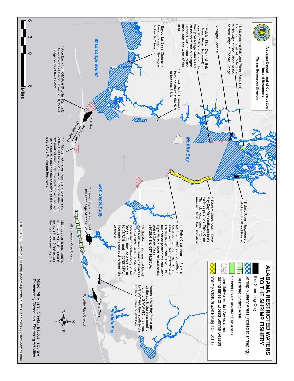
1 K STATE OF ALABAMA DEPARTMENT OF CONSERVATION AND NATURAL RESOURCES MARINE RESOURCES DIVISION POST OFFICE BOX 189 DAUPHIN ISLAND, AL TEL (251) FAX (251) JUNE 2018 RECREATIONAL SHRIMPING REGULATIONS THIS IS NOT AN OFFICIAL COPY OF THE LAWS OR REGULATIONS THIS EXPLANATION OF THE LAWS AND REGULATIONS IS CORRECT AS OF THE DATE SPECIFIED. BEFORE TAKING PART IN THIS FISHERY PLEASE CALL OR OR VISIT OUR WEBSITE FOR UPDATED INFORMATION. IT IS THE FISHERMAN S RESPONSIBILITY TO KNOW THE LAWS AND REGULATIONS IN EFFECT AT ANY GIVEN TIME. Definition: The taking or attempting to take shrimp for bait or any non-commercial purposes by use of a trawl 16 (feet) or less as measured along the main top line. License: Season: A boat license is required. (Nonresidents shall pay a license fee equal to that paid by Alabama residents or boats to shrimp in their state but no less than double the amount provided for above.) *If taken by cast net, a recreational saltwater fishing license is required in addition to the boat license. All inside waters close to commercial and recreational shrimping from 6:00 a.m. May 1 to 6:00 a.m. June 1 of each year. From 6:00 a.m., August 15 th, until 6:00 a.m., October 1 st of each year, the area in Mobile Bay from the center of May Day Pier out to 1/2 nautical mile then south to the northern edge of Point Clear Channel will be open only to the use of a cast net to catch shrimp for non-commercial purposes not to exceed one (1) gallon per person per day. Legal Size: Gallons Allowed: No restriction In areas open to commercial shrimping, five (5) gallons of shrimp with heads intact (whole shrimp including head) per person per day. In exclusive saltwater bait areas, one (1) gallon of shrimp with heads intact (whole shrimp including head) per boat per day. Licensed recreational shrimp boats taking crabs in waters open to commercial shrimping are limited to no more than one five (5)-gallon container of legal size crabs in possession per boat. Individuals taking shrimp, for recreational purposes, in an area open to commercial shrimping by means of a cast net and without the use of a boat, are limited to no more than five (5) gallons of shrimp with head intact (whole shrimp including head) per person per day. Trawl Size: Mesh Size: Other: Not to exceed 16 feet as measured along the main top line. No restriction on cast net. No restriction It is unlawful for any person to drag a net, seine, or trawl over public or private oyster reefs. Commercially licensed boats cannot shrimp in exclusive bait areas. It is unlawful to retain gamefish which includes: red drum, spotted seatrout, tarpon, and striped bass caught with a trawl. It is unlawful to discard dead fish or other dead seafood within 500 feet of any shoreline or into the waters of the Gulf of Mexico within three miles of the Gulf beaches (includes Pelican Bay). The use of any trawl(s) is prohibited in waters closed to shrimping. Little Lagoon is closed to all shrimp trawls which exceed sixteen feet as measured across the cork line or top main line (Rule ). The use of any trawl or trawls, or the taking of shrimp by any means, in any area closed to commercial shrimping is hereby expressly prohibited.
2 PERMANENTLY CLOSED AREAS (SHRIMP TAKEN BY ANY METHOD SHALL NOT BE RETAINED) 1. All rivers*, streams, bayous, and creeks within the State (except Bayou St. John, Old River in Baldwin County and that portion of Blakeley River Designated by law as an exclusive bait shrimp area). *The mouth of the Mobile River is defined as a line running from the southernmost point of Pinto Island due west to a point of the mainland. The mouth of Blakeley River channel is defined as a line running westward from the charted position of the Blakeley River channel marker #18 to a point of intersection with land on the southern tip of Big Island ( N, W). 2. All of Portersville Bay inside a line running from Barron Point west along the south shores of Cat and Marsh Island then west to the south end of Coffee Island (Isle aux Herbes) then north along the western shore of Coffee Island to a point on the mainland directly north of the northernmost tip of Coffee Island (Isle aux Herbes). 3. Heron Bay and that portion of Mississippi Sound north of the Gulf Intracoastal Waterway and east of a line extending from Barron Point on Mon Louis Island southeasterly to range marker D on the Intracoastal Waterway. 4. All of Weeks Bay. 5. Theodore Industrial Canal. 6. Bon Secour Bay within 2500 ft. of the mouth of Weeks Bay. 7. All waters north of the southernmost edge of the Interstate Highway 10 eastbound lane (except that portion of Interstate Highway 10 which lies north of U.S. Highway 90 (Battleship Parkway), in which case the line follows the southernmost edge of the Battleship Parkway. 8. That portion of Mobile Bay north and west of a line running from the intersection of the Dog River Bridge with the Dog River Channel east along the northern edge of the Dog River Channel to its intersection with the Mobile Ship Channel (MSC) then north along the west side of the MSC to the Upper Reach Rear Range (located on the north side of the Arlington Channel) then north and east of a line running southeast to the charted position of Mobile Ship Channel marker #78 then southeast to the charted position of the center of Mayday Pier ( N, W) then eastward along the center of the Mayday Pier to its intersection with land. There shall be a 300-foot safety buffer along the western edge of the MSC where towing a trawl shall be allowed for turning by vessels (exception: One gallon of shrimp per person per day is allowed for bait or noncommercial purposes with a cast net). 9. All waters in Mobile County north of a line beginning at the Mississippi State Line running east to the eastern tip of South Rigolets ( N, W) then northeast to the southwest tip of Point Aux Pins ( N, W) then east to the charted position of the BC Beacon in the Bayou La Batre Ship Channel and then southeast to the northwest point of the middle cut that bisects Coffee Island (Isle aux Herbes) defined as N, W. 10. North of Lillian Bridge in Baldwin County. 11. Little Lagoon Pass in Baldwin County and within 100 yards of the north and south entrance of Little Lagoon Pass. 12. Perdido Pass in Baldwin County which is defined as those waters north of Perdido Pass Chanel markers #1 and #2 and south of the charted position of channel marker #12 in Terry Cove. 13. Exclusive bait areas are permanently closed to commercial shrimping. Note: Indian Bay and Lafitte Bay bottoms (Dauphin Island) are privately owned and may be closed to shrimping.
3 EXCLUSIVE BAIT AREAS (Closed to Commercial Shrimping) (Areas open only to licensed recreational shrimping and live saltwater bait dealers) (Shrimp may only be taken from these exclusive areas from 4:00 a.m. 10:00 p.m.) Baldwin County 1. Wolf Bay: that area encompassing the water within the boundary from the south shore of Wolf Bay northward to Beacon #86 on the north side of the Gulf Intracoastal Waterway then westward along the north side of the Gulf Intracoastal Waterway to Beacon #94 then south across the Gulf Intracoastal Waterway to the south shore of Wolf Bay. 2. Oyster Bay: that area encompassing those waters of Oyster Bay except those waters north of the Gulf Intracoastal Waterway (GIWW). 3. Blakely River: that area encompassing those waters in the mouth of the Blakeley River between the I-10 bridge and the Highway 90 (old causeway) bridge. 4. Terry Cove 1. Arlington Channel Mobile County 2. East Fowl River Channel: from Beacon #5 and #6 to the mouth of the river 3. Bayou la Batre Channel: From Bayou La Batre Channel BC Beacon to the mouth of Bayou La Batre 4. Dauphin Island Bay 5. Buchanan Bay, Confederate Pass, British Bay, Columbia Bay, Colony Bay (Colony Cove), Spanish Bay, Barcelona Bay. SEASONAL BAIT AREAS Areas open exclusively to the commercial and recreational taking of live saltwater bait when adjacent waters are closed Baldwin County 1. Point Clear: that area beginning at a point of land at the southern entrance to the marina at Great Point Clear ( N, W) than southwestwardly to the charted position of Point Clear light #4 then running southeastwardly to a point of land at the end of Zundel Road ( N, W) 2. Mullet Point: beginning at Mullet Point Park ramp then running southwesterly to Tall Rand 2, then southwardly to a point ( N, W), then running due east to terminate on the shore. 3. Ft. Morgan: beginning at the shoreline east of the Gulf Shores Marina at Ft. Morgan then due north one-half nautical mile then due west for one nautical mile, then due south to the shoreline on west side of the Ft. Morgan boat ramp. The area is defined by the following corner points; NW N, W; NE N, W; SW N, W; SE N, W.
4 Mobile County 1. Aloe Bay: from Gulf Intracoastal Waterway Marker #19 running southward to Tall Range D, thence to the western edge of the mouth of Heron Bayou on Dauphin Island, and west of the Dauphin Island Bridge and south of the Gulf Intracoastal Waterway. SPECIAL LIVE BAIT AREAS (PERMIT REQUIRED) 1. Mobile Ship Channel Bait Area: May 1-June 1 During Commercial and Recreational Shrimp Closure. North of a line running through the charted position of Mobile Ship Channel marker #69 and the charted position of Mobile Ship Channel marker #70 and south of a line running through the Upper Rear Range and the charted position of Mobile Ship Channel marker #78. There shall be a 300-foot safety buffer along the western and eastern edge of the described area in the Mobile Ship Channel where towing a trawl shall be allowed for turning by vessels. 2. USS Battleship Alabama Bait Area: In addition, when the area described above is open to commercial shrimping from March 1 through December 31 and only then, an area beside the Battleship south of the Tensaw River Bridge, north of a line from the north point of Pinto Pass to the northwest edge of Goat Island to the eastern end of Tensaw Bridge shall be open for this purpose. RECREATIONAL TED EXEMPTION: No Power or mechanical advantage trawl retrieval system allowed on board boat. All gear must be retrieved by hand. LICENSE PURCHASING: NOTE: Licenses may be purchased online at outdooralabama.com or by mail. Make check or money order payable to: Marine Resources Division. Mail to: License Clerk License Clerk Marine Resources Division Marine Resources Division P.O. Box 189 P.O. Drawer 458 Dauphin Island, AL Gulf Shores, AL 36547
5
JUNE 2018 RECREATIONAL SHRIMPING REGULATIONS
 K STATE OF ALABAMA DEPARTMENT OF CONSERVATION AND NATURAL RESOURCES MARINE RESOURCES DIVISION POST OFFICE BOX 189 DAUPHIN ISLAND, AL 36528 TEL (251) 861-2882 FAX (251) 861-8741 JUNE 2018 RECREATIONAL SHRIMPING
OCTOBER 2018 COMMERCIAL SHRIMPING REGULATIONS
 STATE OF ALABAMA DEPARTMENT OF CONSERVATION AND NATURAL RESOURCES MARINE RESOURCES DIVISION POST OFFICE BOX 189 DAUPHIN ISLAND, AL 36528 TEL (251) 861-2882 FAX (251) 861-8741 OCTOBER 2018 COMMERCIAL SHRIMPING
APRIL 2017 COMMERCIAL SHRIMPING REGULATIONS
 K STATE OF ALABAMA DEPARTMENT OF CONSERVATION AND NATURAL RESOURCES MARINE RESOURCES DIVISION POST OFFICE BOX 189 DAUPHIN ISLAND, AL 36528 TEL (251) 861-2882 FAX (251) 861-8741 APRIL 2017 COMMERCIAL SHRIMPING
August 2018 LIVE BAIT
 STATE OF ALABAMA DEPARTMENT OF CONSERVATION AND NATURAL RESOURCES MARINE RESOURCES DIVISION POST OFFICE BOX 189 DAUPHIN ISLAND, ALABAMA 36528 TEL (251861-2882 FAX (251) 861-8741 August 2018 LIVE BAIT THIS
APRIL 2017 LIVE BAIT
 K STATE OF ALABAMA DEPARTMENT OF CONSERVATION AND NATURAL RESOURCES MARINE RESOURCES DIVISION POST OFFICE BOX 189 DAUPHIN ISLAND, ALABAMA 36528 TEL (251861-2882 FAX (251) 861-8741 APRIL 2017 LIVE BAIT
Use Of Nets And Harvest Of Mullet.
 220-3. 03 Use Of Nets And Harvest Of Mullet. (1) Any person possessing, transporting, or using any seine, gill net, trammel net, or other entangling net more than 300 feet in length as measured along the
Conservation and Natural Resources Chapter ALABAMA DEPARTMENT OF CONSERVATION AND NATURAL RESOURCES ADMINISTRATIVE CODE
 ALABAMA DEPARTMENT OF CONSERVATION AND NATURAL RESOURCES ADMINISTRATIVE CODE CHAPTER 220-3 MARINE RESOURCES DIVISION TABLE OF CONTENTS 220-3-.01 Shrimping 220-3-.02 Oystering 220-3-.03 Use Of Nets And
***This summary does not include shad and herring net requirements.***
 South Carolina Department of Natural Resources Marine Resources Division Summary of Seine and Gill Net Laws (Saltwater) 2013-2014 This document should be kept on board all vessels using seines or gill
15A NCAC 03J.0103 is amended with changes as published in 30:03 NCR as follows:
 1 1 1 1 1 1 1 1 0 1 0 1 1A NCAC 0J.0 is amended with changes as published in 0:0 NCR 1- as follows: 1A NCAC 0J.0 GILL NETS, SEINES, IDENTIFICATION, RESTRICTIONS (a) It is unlawful to use gill nets: (1)
Columbia River Fishery Notice
 Columbia River Fishery Notice Oregon Department of Fish and Wildlife January 29, 2014 Compact Action The Columbia River Compact agencies of Oregon and Washington met today and took the following actions:
Columbia River Fishery Notice
 Columbia River Fishery Notice Oregon Department of Fish and Wildlife July 26, 2018 Compact Action The Columbia River Compact agencies of Oregon and Washington met today and took the following actions:
GULF STATES MARINE FISHERIES COMMISSION. Law Summary A Summary of Marine Fishing Laws and Regulations for the Gulf States
 GULF STATES MARINE FISHERIES COMMISSION Law Summary 1998 A Summary of Marine Fishing Laws and Regulations for the Gulf States December 1998 GSMFC No. 61 This publication is an unofficial compilation of
A SU~~ ()t= MAl:21~~ t=ist-11~«7 IAWS ~() l2~f7uia Tl()~S t=()l2 Tll~ f7ult= STAT~S*
t= MAl:21~~ t=ist-11~«7 IAWS ~() l2~f7uia Tl()~S t=()l2 Tll~ f7ult= STAT~S*") A SU~~ ()t= MAl:21~~ t=ist-11~«7 IAWS ~() l2~f7uia Tl()~S t=()l2 Tll~ f7ult= STAT~S* *An unofficial compilation of marine fishing laws and regulations developed for the information and convenience of enforcement
A SU~~ ()t= MAl:21~~ t=ist-11~«7 IAWS ~() l2~f7uia Tl()~S t=()l2 Tll~ f7ult= STAT~S* *An unofficial compilation of marine fishing laws and regulations developed for the information and convenience of enforcement
VIRGINIA: CitJto/~<Pn Friday 1st day 0/ November, Fee 4. Parking or Stopping Violations * * *
 VIRGINIA: CitJto/~
GULF STATES MARINE FISHERIES COMMISSION. Law Summary. A Summary of Marine Fishing Laws and Regulations for the Gulf States
 GULF STATES MARINE FISHERIES COMMISSION Law Summary 1999 A Summary of Marine Fishing Laws and Regulations for the Gulf States December 1999 GSMFC No. 70 This publication is an unofficial compilation of
OREGON AND WASHINGTON DEPARTMENTS OF FISH AND WILDLIFE JOINT STAFF REPORT SUMMER FACT SHEET NO.
 OREGON AND WASHINGTON DEPARTMENTS OF FISH AND WILDLIFE JOINT STAFF REPORT SUMMER FACT SHEET NO. 1b Columbia River Compact/Joint State Hearing June 14, 2017 Fisheries under consideration: Estuary Recreational
Okeechobee Waterway Speed Restrictions
 Okeechobee Waterway Speed Restrictions Rulemaking Authority 327.46 FS. Law Implemented 327.46 FS. History New 9-18-88, Amended 12-7-89, Formerly 16N-24.010, Amended 10-1- 96, Formerly 62N-24.010, Amended
Submitted by the Alaska Department of Fish and Game at the request of Alaska Board of Fisheries. January 23, 2018
 Submitted by the Alaska Department of Fish and Game at the request of Alaska Board of Fisheries. January 23, 2018 Alaska Board of Fisheries recommendations on Unuk, Chilkat, and King Salmon rivers king
FISCAL IMPACTS OF PROPOSED AMENDMENTS TO RULES 15A NCAC 03J.0209, 03R and 03R.0201
 FISCAL IMPACTS OF PROPOSED AMENDMENTS TO RULES 15A NCAC 03J.0209, 03R. 0112 and 03R.0201 ALBEMARLE SOUND MANAGEMENT AREA SOUTHERN BOUNDARY COORDINATE CHANGE Marine Fisheries Commission (MFC) Agency Contact:
REQUEST FOR TECHNICAL CHANGE
 REQUEST FOR TECHNICAL CHANGE AGENCY: Marine Fisheries Commission RULE CITATION: 1A NCAC 0J.0 DEADLINE FOR RECEIPT: Wednesday, January 1, 01 NOTE WELL: This request when viewed on computer extends several
Final Environmental Impact Statement. for the
 Final Environmental Impact Statement for the Generic Essential Fish Habitat Amendment to the following fishery management plans of the Gulf of Mexico (GOM): SHRIMP FISHERY OF THE GULF OF MEXICO RED DRUM
Law Summary A SuD11Dary of Marine Fishing Laurs and Regulations for tl1e Gulf States
 GULF STATES MARINE FISHERIES COMMISSION Law Summary 1997 --.. - ---... --- ---- A SuD11Dary of Marine Fishing Laurs and Regulations for tl1e Gulf States September 1997 GSMFCNo.49 This publication is an
CHAPTER 260. (House Bill 964) Atlantic Coastal Bays Dredging for Oysters and Clams Prohibition
 Atlantic Coastal Bays Dredging for Oysters and Clams Prohibition") MARTIN O MALLEY, Governor Ch. 260 CHAPTER 260 (House Bill 964) AN ACT concerning Atlantic Coastal Bays Dredging for Oysters and Clams Prohibition FOR the purpose of prohibiting the use of dredging to catch
MARTIN O MALLEY, Governor Ch. 260 CHAPTER 260 (House Bill 964) AN ACT concerning Atlantic Coastal Bays Dredging for Oysters and Clams Prohibition FOR the purpose of prohibiting the use of dredging to catch
SUBCHAPTER 03L SHRIMPS, CRAB, AND LOBSTER SECTION SHRIMP
 SUBCHAPTER 03L SHRIMPS, CRAB, AND LOBSTER SECTION.0100 - SHRIMP 15A NCAC 03L.0101 SHRIMP HARVEST RESTRICTIONS (a) It is unlawful to take shrimp until the Fisheries Director, by proclamation, opens the
SECTION II NM 11/13 NAVIGATION PUBLICATIONS COAST PILOT CORRECTIONS. Chapter 4 Paragraphs 85 to 86; read: (85)
") NAVIGATION PUBLICATIONS COAST PILOT CORRECTIONS COAST PILOT 1 42 Ed 2012 Change No. 13 LAST NM 9/13 Chapter 4 Paragraph 9; read: (9) Round Rock, which uncovers, and The Boring Stone, 3 feet high and bare,
NAVIGATION PUBLICATIONS COAST PILOT CORRECTIONS COAST PILOT 1 42 Ed 2012 Change No. 13 LAST NM 9/13 Chapter 4 Paragraph 9; read: (9) Round Rock, which uncovers, and The Boring Stone, 3 feet high and bare,
Coastal Wetlands Protection Act. Fisheries Management, Marine Sanctuaries and Closures
 , STATE AND LOCAL AUTHORITY FOR MARINE PROTECTION (2014). MISSISSIPPI 1 State Authority for Protection Summary of State Authorities Mississippi has several options for conserving marine habitat; however,
UNOFFICIAL COPY OF HOUSE BILL 853 CHAPTER
 UNOFFICIAL COPY OF HOUSE BILL 853 M2 6lr1662 By: Delegates Bozman, Cane, V. Clagett, Conway, and Hixson Introduced and read first time: February 8, 2006 Assigned to: Environmental Matters Committee Report:
MISSISSIPPI DEPARTMENT OF WILDLIFE, FISHERIES, AND PARKS RULE 5.3 ALLIGATOR HUNTING SEASON FOR PUBLIC WATERS.
 MISSISSIPPI DEPARTMENT OF WILDLIFE, FISHERIES, AND PARKS Title 40: Wildlife, Fisheries, and Parks Part 2: Wildlife Part 2, Chapter 5: Regulations regarding alligators. RULE 5.3 ALLIGATOR HUNTING SEASON
Lake Seminole. and Waters Bordering Georgia and Alabama
 Lake Seminole and Waters Bordering Georgia and Alabama LAKE SEMINOLE Site Description Lake Seminole is a 37,500-acre reservoir located at the juncture of the Florida, Georgia, and Alabama state lines.
PROPOSED AMENDMENTS TO THE REGULATIONS of the POTOMAC RIVER FISHERIES COMMISSION September 8, NOTICE OF HEARING September 8, 2016
 of the POTOMAC RIVER FISHERIES COMMISSION September 8, 2016 Pursuant to the Potomac River Compact of 1958, as duly enacted into law by the General Assemblies of the States of Maryland and Virginia and
License & Fees for Alabama, Florida, Louisiana, Mississippi, and Texas in Their Marine Waters for the Year 2013
 License & Fees for Alabama, Florida, Louisiana, Mississippi, and Texas in Their Marine Waters for the Year 2013 Gulf States Marine Fisheries Commission September 2014 No 233 Gulf States Marine Fisheries
OfflGE COPY ONLY. LICENSES/FEES Required by Alabama, Florida, Louisiana, Mississippi and Texas in Their Marine Waters
 OfflGE COPY ONLY LICENSES/FEES Required by Alabama, Florida, Louisiana, Mississippi and Texas in Their Marine Waters Licenses/Fees Required by Alabama, Florida, Louisiana, Mississippi and Texas in Their
Point No Point Treaty Council
 Point No Point Treaty Council Port Gamble S'Kiallam Jamestown S'Kiallam 2016-2017 Point No Point Treaty Council In-Common Commercial and Subsistence Dungeness Crab Fishery Regulations #S16-052 The following
ELWHA FISHERIES OFFICE
 ELWHA FISHERIES OFFICE 760 Stratton Rd (360) 457-4012 Port Angeles, WA 98363 FAX: (360) 452-4848 July 8, 2017 LOWER ELWHA KLALLAM TRIBE Commercial and Subsistence Dungeness Crab Fishery Regulations S17-035
Descriptor term: Descriptor code: Issue date: SECTION A ORGANIZATION PLAN
 SECTION A ORGANIZATION PLAN A.1...DISTRICT LEGAL STATUS A.2...DISTRICT LEGAL DESCRIPTION A.3...ORGANIZATION PLAN A.4...ORGANIZATIONAL CHART A.5...SCHOOL ATTENDANCE AREAS A.6...SCHOOL CALENDAR DISTRICT
BLACK SEA BASS NORTH OF CAPE HATTERAS DEALER PERMIT ISSUE PAPER. June 12, 2008 (REVISED) (NOTE: proposed rule under construction, eff.
 (NOTE: proposed rule under construction, eff.") BLACK SEA BASS NORTH OF CAPE HATTERAS DEALER PERMIT ISSUE PAPER June 12, 2008 (REVISED) (NOTE: proposed rule under construction, eff. July 1, 2008) I. ISSUE The requirement for licensed dealers to have
BLACK SEA BASS NORTH OF CAPE HATTERAS DEALER PERMIT ISSUE PAPER June 12, 2008 (REVISED) (NOTE: proposed rule under construction, eff. July 1, 2008) I. ISSUE The requirement for licensed dealers to have
Department of Natural Resources. Adopted Expedited Emergency Game and Fish Rules: WATERFOWL SEASON 6240
 Department of Natural Resources Chapters: Adopted Expedited Emergency Game and Fish Rules: 6230 6234 2018 WATERFOWL SEASON 6240 PUBLISHED 05-07-2018 EFFECTIVE 05-07-2018 EXPIRES 01-30-2019 Please see the
License & Fees for Alabama, Florida, Louisiana, Mississippi, and Texas in Their Marine Waters for the Year 2016
 License & Fees for Alabama, Florida, Louisiana, Mississippi, and Texas in Their Marine Waters for the Year 2016 Gulf States Marine Fisheries Commission July 2017 No. 265 Gulf States Marine Fisheries Commission
What are the most recent changes to the Fisheries Regulations in The Bahamas?
 SPORT FISHING What are the most recent changes to the Fisheries Regulations in The Bahamas? Sharks are now protected in The Bahamas as a result of an amendment made in 2011. Sharks may only be taken under
BookletChart. Intracoastal Waterway Matecumbe to Grassy Key NOAA Chart A reduced-scale NOAA nautical chart for small boaters
 BookletChart Intracoastal Waterway Matecumbe to Grassy Key NOAA Chart 11449 A reduced-scale NOAA nautical chart for small boaters When possible, use the full-size NOAA chart for navigation. Published by
GULF SHORES & ORANGE BEACH FISHING YOU LL FIND YOURSELF HOOKED THE MINUTE YOU CAST YOUR LINE.
 GULF SHORES & ORANGE BEACH FISHING YOU LL FIND YOURSELF HOOKED THE MINUTE YOU CAST YOUR LINE. The sun sparkling on the Gulf water is almost as magnificent as the catch you ve been fighting on the end of
68B-31 CHAPTER 68B-31 SHRIMP
 CHAPTER 68B-31 SHRIMP 68B-31.001 Northeast Florida Live Bait Shrimp Fishery; Purpose and Intent. 68B-31.002 Definitions. 68B-31.003 Live Bait Shrimp Trawl Gear Specifications. 68B-31.0035 Trawls: Allowed
MANAGEMENT DESIGNATIONS FOR MARINE AREAS
 Haystack Rock Garden (Inset ) single mussels may be taken for bait. Located within a 3 yard radius around the base of Haystack Rock, Cannon Beach, Clatsop County. Includes tide pools, and rocky or sandy
WATER SURFACE USE ORDINANCE STATE OF MINNESOTA COUNTY OF CROW WING ORDINANCE NO. 83
 WATER SURFACE USE ORDINANCE STATE OF MINNESOTA COUNTY OF CROW WING ORDINANCE NO. 83 AN ORDINANCE REGULATING THE SURFACE USE OF ALL WATERS OF CROW WING COUNTY Be it ordained and enacted by the Crow Wing
REEL FACTS. Regulations. Limblines Fishing with limblines and set hooks is prohibited at Lake Washington.
 Lake Washington 19 REEL FACTS Nathan Aycock Fisheries Biologist NathanA@mdwfp.state.ms.us (61) 432-2 General Information: Lake Washington is a 3, acre oxbow lake of the Mississippi River. It is one of
SUBSIDIARY LEGISLATION FISHERIES REGULATIONS
 Chap. 67:51 7 SUBSIDIARY LEGISLATION FISHERIES REGULATIONS ARRANGEMENT OF REGULATIONS REGULATION Citation 2. Nets. 2A. Use of monofilament nets and mesh. 3. Piah leas thun twelve inches. 4. Fish less than
LICENSES & FEES GULF STATES MARINE FISHERIES COMMISSION
 LICENSES & FEES for Alabama, Florida, Louisiana, Mississippi, and Texas in Their Marine Waters for the Year 2001 GULF STATES MARINE FISHERIES COMMISSION MAY 2002 NO. 100 LICENSES & FEES for Alabama, Florida,
SEAGRANTPROGRAM LAGNIAPPE
 Agricultural Center Louisiana Cooperative State University Extension Service Jefferson Parish Office 1825BonnieAnnDrive Marrero, LA 70072 (504) 349-5640 March 20, 1992 Volume 16, No. 3 SEAGRANTPROGRAM
68D Broward County Boating Restricted Areas.
 68D-24.008 Broward County Boating Restricted Areas. (1) For the purpose of regulating speed and operation of vessel traffic on and adjacent to the Florida Intracoastal Waterway in Broward County, Florida,
ELWHA FISHERIES OFFICE
 ELWHA FISHERIES OFFICE 760 Stratton Rd (360) 457-4012 Port Angeles, WA 98363 FAX: (360) 452-4848 June 7, 2018 LOWER ELWHA KLALLAM TRIBE Commercial and Subsistence Dungeness Crab Fishery Regulations S18-035
FDOT Treasure Coast Traffic Report
 July 6, 2018 Barbara Kelleher, 954 777 4090 Barbara.Kelleher@dot.state.fl.us FDOT Treasure Coast Traffic Report July 6 through July 13, 2018 TREASURE COAST Construction and maintenance related lane closures
MIAMI-DADE COUNTY MANATEE PROTECTION AREAS AND BOATING RESTRICTED AREAS
 MANATEE PROTECTION AREAS AND BOATING RESTRICTED AREAS For description of zone boundaries see: 68C-22.025 F.A.C for State Manatee Protection Zones last amended 2/25/99 68D-24.03 F.A.C. for State Boating
Reef Fish Amendment 32 Gag and Red Grouper
 AMENDMENT GUIDE 11/2/11 Reef Fish Amendment 32 Gag and Red Grouper Provisions in the Magnuson-Stevens Fishery Conservation and Management Act require regional fishery management councils to develop annual
ELWHA FISHERIES OFFICE
 ELWHA FISHERIES OFFICE 760 Stratton Road (360) 457-4012 Port Angeles, WA 98363 FAX: (360) 452-4848 LOWER ELWHA KLALLAM 2018 Annual In-Common Shrimp Regulation S18-019 April 23, 2018 The following regulation
SECTION II CORRECTIONS TO C. G. LIGHT LIST, VOLUME I ATLANTIC COAST,
 CORRECTIONS TO C. G. LIGHT LIST, VOLUME I ATLANTIC COAST, 2011 *10450 360 MARBLEHEAD LIGHT 42-30-19.45N 70-50-01.47W 11760 - Channel Lighted Buoy 28 42-14-53.10N 70-57-43.11W 20410 Gavitt Point Outfall
License & Fees for Alabama, Florida, Louisiana, Mississippi, and Texas in Their Marine Waters for the Year 2017
 License & Fees for Alabama, Florida, Louisiana, Mississippi, and Texas in Their Marine Waters for the Year 2017 Gulf States Marine Fisheries Commission August 2018 No. 278 Gulf States Marine Fisheries
License & Fees for Alabama, Florida, Louisiana, Mississippi, and Texas in Their Marine Waters for the Year 2015
 License & Fees for Alabama, Florida, Louisiana, Mississippi, and Texas in Their Marine Waters for the Year 2015 Gulf States Marine Fisheries Commission August 2016 No. 253 Gulf States Marine Fisheries
Geographic Response Plan Map: SC-17
 79 37'30"W Geographic Response Plan Map: SC-17 79 30'0"W 33 7'30"N Charleston County 33 7'30"N 33 0'0"N 79 37'30"W [ Awendaw [j [e!d!s(!d Graham Creek FRANCIS MARION NATIONAL FOREST 450 Awendaw Creek [j
TITLE 800. DEPARTENT OF WILDLIFE CONSERVATION CHAPTER 10. SPORT FISHING RULES SUBCHAPTER 1. HARVEST AND POSSESSION LIMITS
 TITLE 800. DEPARTENT OF WILDLIFE CONSERVATION CHAPTER 10. SPORT FISHING RULES SUBCHAPTER 1. HARVEST AND POSSESSION LIMITS 800:10-1-3. Additional definitions The following words or terms, when used in this
1501: Seasons and limits on ducks, brant, geese, mergansers, and coots.
 ACTION: Original DATE: 02/10/2017 2:08 PM 1501:31-7-06 Seasons and limits on ducks, brant, geese, mergansers, and coots. (A) Throughout the state, it shall be unlawful for any person to hunt, kill, wound,
License & Fees for. .-!! aba 111a, Florida, Louisiau a, Jlississippi, au d Te-:\. as iu Their Jlariue TJ(1ters for the I ear :010. Se1>t 2011 No.
 License & Fees for.-!! aba 111a, Florida, Louisiau a, Jlississippi, au d Te-:\. as iu Their Jlariue TJ(1ters for the I ear :010 f-tjli f). Se1>t 2011 No. 193 Gulf States Marine Fisheries Commission Commissioners
Pascagoula River Marsh 2017 REEL FACTS Stephen Brown Fisheries Biologist
 Pascagoula River Marsh 217 REEL FACTS Stephen Brown Fisheries Biologist stephenb@mdwfp.state.ms.us General Information: The Pascagoula River marsh is 25 acres of tidal creeks, canals, bays, and streams
FISCAL IMPACTS OF PROPOSED AMENDMENTS TO THE N.C. RIVER HERRING FISHERY MANAGEMENT PLAN
 1 FISCAL IMPACTS OF PROPOSED AMENDMENTS TO THE N.C. RIVER HERRING FISHERY MANAGEMENT PLAN Rule Amendments: Name of Commission: Agency Contact: 15A NCAC 03J.0209 ALBEMARLE SOUND/CHOWAN RIVER RIVER HERRING
State of Texas Operations and Maintenance
 State of Texas Operations and Maintenance Barbour Terminal Ship Channel The Barbour Terminal Channel and Turning Basin is a 1.7-mile-long deep draft waterway that extends from the Houston Ship Channel
Amendment 1 to the NC Red Drum FMP MFC Meeting
 Amendment 1 to the NC Red Drum FMP MFC Meeting 4-22-2008 Summary of DMF and AC Recommendations and Public Comment Inland AC Raleigh 3/4/08 Central AC New Bern 3/5/08 Northeast AC Buxton 3/6/08 Southeast
@llll /Xll Fishing Waters Guide
 @ @)f @ @llll /Xll Fishing Waters Guide SEA GRANT ADVSORY SERVCE MSSSSPP COOPERATVE EXTENSON SERVCE Yr ff DlL 1Al Fishing Waters HARRSON COUNTY, MSSSSPP LEGEND - Fishing license required inland a Boat
DEPARTMENT OF THE ARMY GALVESTON DISTRICT, CORPS OF ENGINEERS P.O. BOX 1229 GALVESTON, TEXAS CESWG-CDR (1145)
") DEPARTMENT OF THE ARMY GALVESTON DISTRICT, CORPS OF ENGINEERS P.O. BOX 1229 GALVESTON, TEXAS 77553-1229 REPLY TO ATTENTION OF CESWG-CDR (1145) TBD MEMORANDUM FOR All Galveston District Personnel. SUBJECT:
DEPARTMENT OF THE ARMY GALVESTON DISTRICT, CORPS OF ENGINEERS P.O. BOX 1229 GALVESTON, TEXAS 77553-1229 REPLY TO ATTENTION OF CESWG-CDR (1145) TBD MEMORANDUM FOR All Galveston District Personnel. SUBJECT:
Pascagoula River Marsh 2018 REEL FACTS Stephen Brown Fisheries Biologist
 Pascagoula River Marsh 218 REEL FACTS Stephen Brown Fisheries Biologist stephenb@mdwfp.state.ms.us General Information: The Pascagoula River marsh is 25 acres of tidal creeks, canals, bays, and streams
December 15, Supplement to POTOMAC RIVER FISHERIES COMMISSION BOOK OF REGULATIONS
 December 15, 2017 Supplement to POTOMAC RIVER FISHERIES COMMISSION BOOK OF REGULATIONS This supplement should be inserted inside the back cover of the January 1, 2018 edition of the Potomac River Fisheries
WHEREAS, the ordinance will not create excessive additional requirements for public facilities and services at public cost.
 ORDINANCE 19-05 AN ORDINANCE OF VALLEY COUNTY, IDAHO, CREATING AN ORDINANCE TO BE ADMINISTERED BY THE VALLEY COUNTY SHERIFF S OFFICE AND TO BE KNOWN AS VALLEY COUNTY WATERWAYS ORDINANCE THAT INCLUDES PAYETTE
FDOT Treasure Coast Traffic Report
 July 13, 2018 Barbara Kelleher, 954 777 4090 Barbara.Kelleher@dot.state.fl.us FDOT Treasure Coast Traffic Report July 13 through July 20, 2018 TREASURE COAST Construction and maintenance related lane closures
Georgia Inshore Artificial Reefs. Chatham. Georgia [ Romerly Marsh Creek. Bear River. [ Timmons River. Island. Sapelo. Island. Wolf. Island.
 Georgia Inshore Artificial Reefs 81 30'0"W 32 0'0"N South Carolina 81 0'0"W Tybee Chatham North Carolina Halfmoon River Georgia Romerly Marsh Creek Atlantic Ocean Gulf of Mexico 32 0'0"N Bryan Florida
THE FISHERIES (GENERAL) REGULATIONS 1950, AMENDMENT NO. 36. DA VID BEATTIE, Governor-General ORDER IN COUNCIL
 REGULATIONS 1950, AMENDMENT NO. 36. DA VID BEATTIE, Governor-General ORDER IN COUNCIL") 1665 THE FISHERIES (GENERAL) REGULATIONS 1950, AMENDMENT NO. 36 DA VID BEATTIE, Governor-General ORDER IN COUNCIL At the Government House at Wellington this 27th day of October 1981 Present: HIS EXCELLENCY
1665 THE FISHERIES (GENERAL) REGULATIONS 1950, AMENDMENT NO. 36 DA VID BEATTIE, Governor-General ORDER IN COUNCIL At the Government House at Wellington this 27th day of October 1981 Present: HIS EXCELLENCY
Commercial Saltwater Fishing Regulations
 Commercial Saltwater Fishing Regulations Printed March 2018 Table of Contents ABBREVIATIONS... 3 DEFINITIONS... 3 GENERAL REQUIREMENTS... 4 COMMERCIAL LICENSES... 4 Commercial Fishing License... Error!
(e) For the purpose of this section, a menhaden dealer is:
 For the purpose of this section, a menhaden dealer is:") Fis 603.21 Atlantic Menhaden. (a) No person shall take, land, possess, or transfer possession of Atlantic menhaden (Brevortia tyrannus) while on or leaving the waters under the jurisdiction of the state
Fis 603.21 Atlantic Menhaden. (a) No person shall take, land, possess, or transfer possession of Atlantic menhaden (Brevortia tyrannus) while on or leaving the waters under the jurisdiction of the state
Chart Features Maritime maps and Admiralty charts have these features:
 Introduction to Charts A chart or map of the area is an important safety item to carry on board. It allows the Master to obtain knowledge of the area to be travelled, and indicates the navigable channels
OFFICE COPY ONLY. STAT L G1SLAT10'N AFF CT1'NG MAR1'N TlSH R1 S GVLF OF M X1CO SEPTEMBER :r~-~-: :: h_.,; '...
 OFFICE COPY ONLY STAT L G1SLAT10'N AFF CT1'NG MAR1'N TlSH R1 S GVLF OF M X1CO - SEPTEMBER 1992 :: h_.,; '......-:r~-~-: INTRODUCTION LEGISLATION AFFECTING MARINE FISHERIES 1992 During its spring meeting
2018 Fraser River Fishery Summary to Accompany December 2018 Presentation for FORUM
 2018 Fraser River Fishery Summary to Accompany December 2018 Presentation for FORUM Chinook... 1 Coho... 3 Chum... 4 Sockeye... 5 Pink... 6 Chinook FSC Chinook directed fisheries were open year round Below
PRAWN FISHERY MANAGEMENT PLAN, 2010
 PRAWN FISHERY MANAGEMENT PLAN, 2010 [L.N. 20/2011.] SCHEDULE 1. Citation This Management Plan shall be cited as The Prawn Fishery Management Plan 2010 hereinafter referred to as The Management Plan. 2.
Starting Bid: $15,000
 Starting Bid: $15,000 Parcel # 12.00593.00 Garage Legal Description Information Lot-005 Block-006 FOREST EDGE ADDITION Eckles Township 20 147 34 Forfeited: 06-222018 Deeded acres: 1.33 Appraised Value
For the purposes of any clarification and legal interpretation the original byelaw should referred to.
 Sussex Inshore Fisheries and Conservation Authority Byelaw guidance for marine fisheries and conservation management Marine Protected Areas Byelaw 2015 Schedule 1: Kingmere Marine Conservation Zone Introduction
Licenses & Fees. For Alabama, Florida, Louisiana, Mississippi, and Texas In Their Marine Waters for the Year March 2005 No.
 Licenses & Fees For Alabama, Florida, Louisiana, Mississippi, and Texas In Their Marine Waters for the Year 2004 March 2005 No. 130 Licenses & Fees For Alabama, Florida, Louisiana, Mississippi, and Texas
XXX. Chisolm Island Creeks. Map Continued on SC-48. Judge Island. SC49-03 Jenkins Creek/Morgan River Intersection XXX. Saint Helena Island
 w River 32 30'0"N ufort County 80 37'30"W 802 Coosaw River 250 450 SC41-05 Geographic Response SC41-03 Plan Map: Coosaw SC-49 River Chisolm Island Chisolm Island s u Map Continued on SC-41 3 (west side)
CHAPTER House Bill No. 1213
 CHAPTER 2015-198 House Bill No. 1213 An act relating to the West Palm Beach Water Catchment Area, Palm Beach County; amending chapter 67-2169, Laws of Florida, as amended; revising boundaries; providing
TEXAS PARKS AND WILDLIFE DEPARTMENT LAW ENFORCEMENT DIVISION FISHERIES ENFORCEMENT ALONG THE TX/MX BORDER
 TEXAS PARKS AND WILDLIFE DEPARTMENT LAW ENFORCEMENT DIVISION FISHERIES ENFORCEMENT ALONG THE TX/MX BORDER REGION 8 JOINT IUU OPERATIONS CAMERON/HIDALGO COUNTIES - PORTS OF ENTRY FEBRUARY 2018 PARTICIPATING
RULES OF GEORGIA DEPARTMENT OF NATURAL RESOURCES COASTAL RESOURCES DIVISION CHAPTER SALTWATER FISHING REGULATIONS TABLE OF CONTENTS
 Saltwater Fishing Regulations Chapter 391-2-4 RULES OF GEORGIA DEPARTMENT OF NATURAL RESOURCES COASTAL RESOURCES DIVISION CHAPTER 391-2-4 SALTWATER FISHING REGULATIONS TABLE OF CONTENTS 391-2-4-.09 Commercial
SUBCHAPTER 03K - OYSTERS, CLAMS, SCALLOPS AND MUSSELS SECTION.0100 SHELLFISH, GENERAL
 SUBCHAPTER 03K - OYSTERS, CLAMS, SCALLOPS AND MUSSELS SECTION.0100 SHELLFISH, GENERAL 15A NCAC 03K.0101 PROHIBITED SHELLFISH AREAS/ACTIVITIES (a) It is unlawful to possess, sell, or take oysters, clams
Fishing for Red Drum
 Fishing for Red Drum Overview: Grade Level 5 th -8 th Objectives * To be able generate a graph based on current fishery data. * To be able to predict red drum weights and ages based on length. * To understand
MIAMI-DADE COUNTY MANATEE PROTECTION AREAS
 MANATEE PROTECTION AREAS For description of zone boundaries see: 68C-22.025 F.A.C for State Manatee Protection Zones last amended 2/25/99 For infomation please call or write to: Fish and Wildlife Conservation
OREGON AND WASHINGTON DEPARTMENTS OF FISH AND WILDLIFE JOINT STAFF REPORT SUMMER FACT SHEET NO.
 OREGON AND WASHINGTON DEPARTMENTS OF FISH AND WILDLIFE JOINT STAFF REPORT SUMMER FACT SHEET NO. 1 Columbia River Compact/Joint State Hearing June 28, 2018 Fisheries under consideration: Treaty commercial
FDOT Treasure Coast Traffic Impact Report
 January 20, 2017 Chuck McGinness, 954 777 4302 chuck.mcginness@dot.state.fl.us FDOT Treasure Coast Traffic Impact Report January 20 through January 27, 2017 TREASURE COAST Construction and maintenance
Code of Federal Regulations
 Page 1 of 6 Code of Federal Regulations Title 33 - Navigation and Navigable Waters Volume: 2 Date: 2010-07-01 Original Date: 2010-07-01 Title: Section 165.1325 - Regulated Navigation Areas; Bars Along
Delaware Division of Fish & Wildlife. Year 2005 Tidal Water Recreational Fishing Limits
 Delaware Division of Fish & Wildlife Year 2005 Tidal Water Recreational Fishing Limits No license is required for hook and line recreational fishing in tidal waters. It is illegal to fish for any species
BookletChart. Chesapeake Bay Severn and Magothy Rivers NOAA Chart A reduced-scale NOAA nautical chart for small boaters
 BookletChart Chesapeake Bay Severn and Magothy Rivers NOAA Chart 12282 A reduced-scale NOAA nautical chart for small boaters When possible, use the full-size NOAA chart for navigation. Published by the
ROUTE 2. Bateau Channel. Topographic Map 31 C/8 Navigation Charts 1438/39 Reference Maps
 Topographic Map 31 C/8 Navigation Charts 1438/39 Reference Maps ROUTE 2 Bateau Channel The shoreline marshes of the Bateaux Channel team with life. Wetlands provide breeding habitat for amphibians, fish
FISCAL NOTE FOR PROPOSED AMENDMENTS TO RULE 15A NCAC 03O A NCAC 03O.0503 PERMIT CONDITIONS; SPECIFIC
 FISCAL NOTE FOR PROPOSED AMENDMENTS TO RULE 15A NCAC 03O.0503 SPINY DOGFISH DEALER PERMIT Rule Amendments: Name of Commission: Agency Contact: Impact Summary: 15A NCAC 03O.0503 PERMIT CONDITIONS; SPECIFIC
SPECIAL ACTS OF LOCAL APPLICATION
 SPECIAL ACTS OF LOCAL APPLICATION BAY COUNTY BREVARD COUNTY BROWARD COUNTY CHARLOTTE COUNTY CITRUS COUNTY CLAY COUNTY COLLIER COUNTY COLUMBIA COUNTY DADE COUNTY DIXIE COUNTY DUVAL COUNTY ESCAMBIA COUNTY
MISSISSIPPI COMMISSION ON WILDLIFE, FISHERIES, AND PARKS MISSISSIPPI DEPARTMENT OF WILDLIFE, FISHERIES, AND PARKS
 MISSISSIPPI COMMISSION ON WILDLIFE, FISHERIES, AND PARKS MISSISSIPPI DEPARTMENT OF WILDLIFE, FISHERIES, AND PARKS Title 40: Wildlife, Fisheries, and Parks Part 3: Fisheries Part 3, Chapter 3: Regulations
Harbor Porpoise Take Reduction Plan: New England
 Harbor Porpoise Take Reduction Plan: New England Photo Ann-Louise Jensen / Fjord & Bælt Centre NOAA Fisheries Service U.S. Department of Commerce National Oceanic and Atmospheric Administration National
FALL FACT SHEET NO. 1 Columbia River Compact July 29, Non-Indian Select Areas
 FALL FACT SHEET NO. 1 Columbia River Compact July 29, 2004 Fisheries Under Consideration: Non-Indian commercial mainstem Non-Indian Select Areas MANAGEMENT GUIDELINES Salmon A Management Agreement for