Fish Community. Fish Habitat, Streams and Rivers
|
|
|
- Oswin Gray
- 6 years ago
- Views:
Transcription
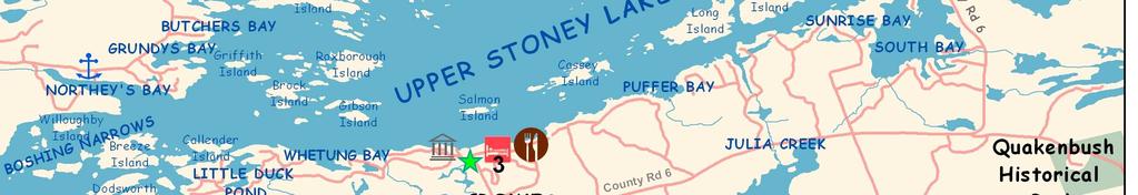
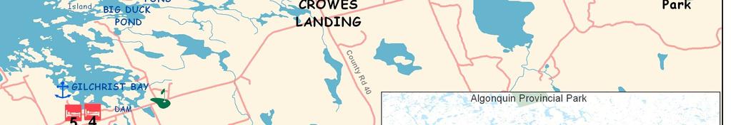
1 Clear, Ston(e)y and White Lake Plan Fish Community The lakes support a cool/warm water fishery including muskellunge, walleye, largemouth and smallmouth bass, yellow perch, pumpkinseed, rockbass, blue gill, bullhead, black crappie and carp. Several of these species, including walleye, have been introduced to Ston(e)y Lake. Muskellunge, however, are naturally found in the lakes, but their population remains low at least partly due to environmental stresses including habitat alteration and the presence of invasive species. For example, zebra mussels increase water clarity, having an adverse effect on zooplankton and small fish communities via predation. Loss of these species eventually affects the food chain. In turn muskie populations are at risk. The migration of northern pike from other reaches of the TSW system is also a potential future stressor. Historic records indicate that our lakes and streams once provided a good habitat for 28 species, including cold water species such as lake herring, lake white fish, lake trout, Atlantic salmon and freshwater shrimp. However, changes in land use and resultant impacts to water quality, water level and temperature changes and doubtless other factors have resulted in a dramatic decline approaching complete loss of these species. Although bass, walleye, muskellunge and brook trout were stocked during the 1900s, this practice has been discontinued. Upper Stoney Lake also maintains some cold water habitat for its lake herring and lake whitefish population. An MNR netting program in 2005 confirmed the presence of both species. Fish Habitat, Streams and Rivers Fish Habitat The preferred habitats for muskellunge and largemouth bass are the vegetated or mudbottomed wetland-type areas for breeding, nurseries and feeding. Walleye breed in fastmoving pebbly or rocky shoreline areas and rivers, devoid of dense vegetation. Smallmouth bass are often observed in or near walleye habitats. These fish prefer hard-bottomed areas of clear water, with clean gravel, sand or rocky substrate found in quiet bays, island shoals and undisturbed shorelines. Important wetland and shoreline habitat for muskellunge is shown on Map 3. Sporadic data collected by the Trent-Severn Waterway, Ministry of Natural Resources, and locally funded independent studies were incorporated in our mapping efforts. The darker areas indicate historic spawning beds for muskellunge and the adjacent areas indicate protective buffer zones for consideration in any further development or change to the lake. Muskellunge may become lost to our lakes like the lake trout if management efforts fail to protect this species. Map 4 (on the next page) also shows a Fish Sanctuary area, in which fishing is prohibited from the opening of the panfish season (end of April) for an extra week after the walleye season opens on the second Saturday in May. This is consistent with other fast water sanctuaries in the area, and protects walleye as they gather before, during and post-spawning. This type of protection is part of the Ministry of Natural Resources Kawartha-wide initiative to focus on the decline in walleye.

2 2 Clear, Ston(e)y and White Lake Plan
3 Clear, Ston(e)y and White Lake Plan 3
y")

4 4 Clear, Ston(e)y and White Lake Plan
5 Clear, Ston(e)y and White Lake Plan 5 OBSERVED THREATS TO FISH AND FISH HABITAT Modification of fisheries habitat: alterations to shoreline and lake bed via filling, dredging, removal of aquatic vegetation, channelizing, docks and boathouses and retaining walls, and the removal of natural habitat such as stumps, logs, and rocks. Most notable is the incremental loss/change in habitat for our valued indicator species - those species which indicate an environmental condition such as a disease outbreak, pollution, species competition or climate change. Indicator species can be among the most sensitive species in a region, acting as an early warning to monitoring biologists. In our region, muskie is the indicator species; and there are documented declines in catch of both muskie and walleye. Over-fishing, poaching or angling out of season of all fish species: particularly walleye and panfish. Impacts of invasive species: increasing clarity of the water by zebra mussels permits deeper light penetration which encourages plant growth and increases water load concentration of Nutrients. Loss of deep-water dissolved oxygen and deep-water fish habitat disrupts the natural food chain and increases competition for forage fish. An acceptable baitfish species education program would help minimize the risk of introducing other invasive species. Excessive nutrient loading and pollution: from fertilizing lawns, grey water dumping or release from holding tanks, and septic systems causing excessive weed growth. Climate change: increasing water temperatures favouring other species and causing weed growth. RECOMMENDATIONS FISH HABITAT 17. Protect all fish habitat, including all wetlands and natural shoreline areas via government due diligence in permitting and development applications. 18. Encourage replacement of ageing shoreline infrastructure (failing armour stone walls, concrete docks) with natural features instead of upgrading existing structures. 19. Conduct research to confirm wetland fisheries habitat for indicator species. 20. Encourage agencies to inventory the current lake stock and help formulate a plan for sustainability, including monitoring of species at risk. 21. Actively promote best practices for homeowners and fishing enthusiasts to protect fisheries and fisheries habitat.


,")
6 6 Clear, Ston(e)y and White Lake Plan Streams and Rivers Streams and rivers are a significant feature of the landscape and an integral source of water to the lake. Both systems provide important habitat for fish and wildlife, as well as freshwater from ground sources. OBSERVATIONS STREAMS AND RIVERS There are a total of 35 streams connected to Ston(e)y and Clear Lakes, including Eel s, Jack s, Perry s and Julia Creeks, and two outflows via the Indian and Otonabee Rivers. Several of these streams are intermittent; that is, a stream which dries up for three months or more of the year. All of the streams occur on privately-owned land. Only three streams have been assessed for thermal regimes (temperature of the water) which defines fish habitats; two feeding Big Duck Pond and one feeding Hull Bay. Inappropriate development and human activity may threaten stream fish habitats and communities through the loss of riparian vegetation, removal of structural habitat (woody debris and rocks), sedimentation, nutrient impacts, channelization, herbicides, pesticides infilling, dredging, damming and changes in flow regime. Big Duck Pond, Stoney Lake RECOMMENDATIONS STREAMS AND RIVERS 22. Promote naturalized buffer zones for streams; 15 metres for warm and 30 metres for cold waters. 23. Expand stream inventories to identify and map important fish habitat. The Disappearing Stream on the Elliott property Bridge to Green Island
Fisheries and Lake Management Planning. CAP Mtg Nov21,2012 Brett Tregunno Aquatic Biologist, Kawartha Conservation
 Fisheries and Lake Management Planning CAP Mtg Nov21,2012 Brett Tregunno Aquatic Biologist, Kawartha Conservation Outline Aquatic Habitat Types Fish Communities Significance of Resource Current Management
HUBBARD LAKE Alcona County (T27N, R7E; T28N, R7E) Surveyed May and September Tim A. Cwalinski
 Surveyed May and September Tim A. Cwalinski") Michigan Department of Natural Resources Status of the Fishery Resource Report No. 2003-1, 2003 HUBBARD LAKE Alcona County (T27N, R7E; T28N, R7E) Surveyed May and September 1996 Tim A. Cwalinski Environment
Michigan Department of Natural Resources Status of the Fishery Resource Report No. 2003-1, 2003 HUBBARD LAKE Alcona County (T27N, R7E; T28N, R7E) Surveyed May and September 1996 Tim A. Cwalinski Environment
Thunder Bay River Assessment Appendix. Appendix 2
 Appendix 2 Known past and present fish distributions in the River system. Distribution of fishes were compiled from Bailey et al. (2003) and from records located at the Michigan Department of Natural Resources
Water Habitat Model. Outcome: Materials: Teacher Instructions: : Identify the components of an animal habitat..
 Water Habitat Model Outcome: 4-1-03: Identify the components of an animal habitat.. Materials: Shoe boxes (1 per student) Art supplies: Glue and/or tape Paint and brushes for the background Plasticine/clay
Geology. Key Factors. Overfishing. Great Lakes Fishes. Historical Fishing. About 10,000 years since last glacial retreat very young ecologically
 Great Lakes Fishes Geology About 10,000 years since last glacial retreat very young ecologically Largest surface freshwater system on earth 21% of world s supply 84% of North America s supply Five unique
Columbia Lake Dam Removal Project
 Columbia Lake Dam Removal Project The Columbia Lake dam located 1/4 mile upstream of the Paulins Kill River's confluence with the Delaware River in Knowlton Township, Warren County has been proposed for
Aquatic Plant Management and Importance to Sport Fisheries
 Aquatic Plant Management and Importance to Sport Fisheries Presentation to Michigan Inland Lakes Convention May 2014 Mike Maceina Professor Emeritus School of Fisheries, Aquaculture, and Aquatic Sciences
Alcona Dam Pond Alcona County (T25N, R5E, Sections various) Surveyed June 6-12 and September 16, 2003
 Surveyed June 6-12 and September 16, 2003") Michigan Department of Natural Resources Status of the Fishery Resource Report No. 2004-6, Year 2004 Alcona Dam Pond Alcona County (T25N, R5E, Sections various) Surveyed June 6-12 and September 16, 2003
Michigan Department of Natural Resources Status of the Fishery Resource Report No. 2004-6, Year 2004 Alcona Dam Pond Alcona County (T25N, R5E, Sections various) Surveyed June 6-12 and September 16, 2003
Current Status and Management Recommendations for the Fishery in the Cloverleaf Chain of Lakes
 Current Status and Management Recommendations for the Fishery in the Cloverleaf Chain of Lakes Jason Breeggemann Senior Fisheries Biologist Wisconsin Department of Natural Resources Outline DNR fisheries
Summary of and Initial Response to public comments on MN Department of Natural Resources proposal to manage new waters for Muskellunge
 Summary of and Initial Response to public comments on MN Department of Natural Resources proposal to manage new waters for Muskellunge Summary of and Initial Response to public comments: This document
FISH COMMUNITIES AND FISHERIES OF THE THOUSAND ISLANDS AND MIDDLE CORRIDOR
 St. Lawrence River Discussion Paper FISH COMMUNITIES AND FISHERIES OF THE THOUSAND ISLANDS AND MIDDLE CORRIDOR Issues Below is a synopsis of fish community issues and proposed management approaches. More
Keuka Lake State of the Lake 2017
 Keuka Lake State of the Lake 2017 1 2 Lake Characteristics Third largest by area of the Finger Lakes 11,730 ac Deep and steep sided - max 185 ft mean 101 ft Two story fishery (warmwater/coldwater) 178,800
LAKE DIANE Hillsdale County (T8-9S, R3W, Sections 34, 3, 4) Surveyed May Jeffrey J. Braunscheidel
 Surveyed May Jeffrey J. Braunscheidel") Michigan Department of Natural Resources Status of the Fishery Resource Report No. 2003-4, 2003 LAKE DIANE Hillsdale County (T8-9S, R3W, Sections 34, 3, 4) Surveyed May 2001 Jeffrey J. Braunscheidel Environment
Michigan Department of Natural Resources Status of the Fishery Resource Report No. 2003-4, 2003 LAKE DIANE Hillsdale County (T8-9S, R3W, Sections 34, 3, 4) Surveyed May 2001 Jeffrey J. Braunscheidel Environment
Cedar Lake Comprehensive Survey Report Steve Hogler and Steve Surendonk WDNR-Mishicot
 Cedar Lake- 2006 Comprehensive Survey Report Steve Hogler and Steve Surendonk WDNR-Mishicot ABSTRACT Cedar Lake is a 142 acre lake located in the southwest corner of Manitowoc County. It is a seepage lake
2014 Island Lake Survey June 13 th, 2014 Andrew Plauck District Fisheries Biologist Report Prepared 4 March 2015
 2014 Island Lake Survey June 13 th, 2014 Andrew Plauck District Fisheries Biologist Report Prepared 4 March 2015 BACKGROUND - A fish survey was requested due to a moderately severe winterkill in Island
ADOPT-A-STREAM WATERSHED APPROACH COMMUNITY-BASED STEWARDSHIP. Nova Scotia Salmon Association March 2005
 ADOPT-A-STREAM A WATERSHED APPROACH TO COMMUNITY-BASED STEWARDSHIP Nova Scotia Salmon Association March 2005 This manual is a revised and updated version of the 1994 Adopt-a-Stream manual that was prepared
THE FISHERY IN KENNEBEC LAKE Prepared by: Cam McCauley Landscape Planning Biologist Peterborough District, i t Kingston
 THE FISHERY IN KENNEBEC LAKE Prepared by: Cam McCauley Landscape Planning Biologist Peterborough District, i t Kingston 613-531-57055705 Questions 1. How many walleye and age structure now? 2. Status of
BIG TWIN LAKE Kalkaska County (T28N, R05W, Section 18, and T28N, R06W, Section 13) Surveyed May 1999
 Surveyed May 1999") Michigan Department of Natural Resources Status of the Fishery Resource Report No. 2001-1, Year 2001 BIG TWIN LAKE Kalkaska County (T28N, R05W, Section 18, and T28N, R06W, Section 13) Surveyed May 1999
Michigan Department of Natural Resources Status of the Fishery Resource Report No. 2001-1, Year 2001 BIG TWIN LAKE Kalkaska County (T28N, R05W, Section 18, and T28N, R06W, Section 13) Surveyed May 1999
December 18, Dear Sir/Madam,
 December 18, 2000 Dear Sir/Madam, We are writing to bring you up-to-date on our efforts to develop fish community objectives for the St. Lawrence River. First of all, we want to thank you for participating
Quemahoning Reservoir
 Pennsylvania Fish & Boat Commission Biologist Report Quemahoning Reservoir Somerset County May 2011 Trap Net, Gill Net and Electrofishing Survey Quemahoning Reservoir is an 899 acre impoundment located
Crawford Reservoir. FISH SURVEY AND MANAGEMENT INFORMATION Eric Gardunio, Fish Biologist Montrose Service Center
 FISH SURVEY AND MANAGEMENT INFORMATION General Information: Crawford Reservoir is a popular fishery that provides angling opportunity for yellow perch, channel catfish, northern pike, rainbow trout, black
Current projects for Fisheries Research Unit of Minnesota Department of Natural Resources
 Current projects for Fisheries Research Unit of Minnesota Department of Natural Resources MAJOR RESOURCE ISSUES IN THE DIVISION OF FISHERIES Status of Fish Populations To effectively manage fish populations,
First Nations Fish Habitat Program Discussion Workbook
 First Nations Fish Habitat Program Discussion Workbook The First Nations Fish Habitat Program is a joint initiative of the Centre for Indigenous Environmental Resources (CIER) and The Southern Chiefs Organization
Ebert Lake 8 Lime Lake - 13
 8 - Number of responses Number of Responses Amount of Aquatic Plant Growth..5..5. Amount of aquatic plant growth.5 7. very_little right_amount dense_growth not_sure no_response 6 5 Dense_growth Choked_growth
Fisheries Management Plan for Fisheries Management Zone 17: November Ontario Ministry of Natural Resources Peterborough District
 Fisheries Management Plan for Fisheries Management Zone 17: November 2009 Ontario Ministry of Natural Resources Peterborough District Fisheries Management Plan for Fisheries Management Zone 17 November
Lake Trout. Appendix A: Fish. Salvelinus namaycush. New Hampshire Wildlife Action Plan Appendix A Fish-158
 Lake Trout Salvelinus namaycush Federal Listing State Listing Global Rank State Rank Regional Status S5 High Photo by NHFG Justification (Reason for Concern in NH) Native populations of lake trout were
Bode Lake - South Population Survey
 Bode Lake - South Survey Located in Hoffman Estates on the north side of Bode Rd. 1 mile west of Barrington Rd. Bode Lake is made up of two lakes along Poplar Creek; the larger and deeper Bode Lake South
SUMMARY REPORT FOR LAKE ST. MALO FISHERIES ASSESSMENT. Prepared for the St. Malo and District Wildlife Association
 SUMMARY REPORT FOR LAKE ST. MALO FISHERIES ASSESSMENT Prepared for the St. Malo and District Wildlife Association Presented by August 25, 2014 Study dates thus far: Date Tasks February 16 Fishing derby;
Onondaga Lake Fishery: 2011 Fact Sheet
 October, 2011 Onondaga County Department of Water Environment Protection SUNY College of Environmental Science and Forestry Joanne M. Mahoney, County Executive Tom Rhoads, P.E., Commissioner Onondaga Lake
Pennsylvania Fish & Boat Commission Biologist Report. Wilmore Dam. Cambria County. May 2011 Trap Net, Electrofishing and Hoop Net Survey
 Pennsylvania Fish & Boat Commission Biologist Report Wilmore Dam Cambria County May 2011 Trap Net, Electrofishing and Hoop Net Survey Wilmore Dam is a 195 acre impoundment located in central Cambria County
Overview of Recreational Pond Management
 Overview of Recreational Pond Management extension November 13 th 2013 Forrest Wynne State Extension Specialist for Aquaculture Kentucky State University Ponds are built for some of the following purposes:
Caro Impoundment, Tuscola County
 Caro Impoundment is a 200 acre impoundment of the Cass River located one mile south of the Village of Caro in Tuscola County. Caro Dam, originally constructed in 1906 for water supply to Michigan Sugar
I Region I Area I DOW Number / County I DOW Lake Name I Acreage I
 LAKE MANAGEMENT PLAN 814 Bp I Region I Area I DOW Number / County I DOW Lake Name I Acreage I I I # I f 2 Duluth F213 690036 St Louis Salo DOW:149 Plan: 137 Long Range Goal: Manage for walleye with a gillnet
(date are inclusive)
") Kind of Fish and Locality Methods Permitted Open Season (date are inclusive) Bag Limit Maximum or Minimum Size Limits (a) LARGE MOUTH AND SMALLMOUTH BASS. (i) All waters Hook & Line ice fishing (including
Kind of Fish and Locality Methods Permitted Open Season (date are inclusive) Bag Limit Maximum or Minimum Size Limits (a) LARGE MOUTH AND SMALLMOUTH BASS. (i) All waters Hook & Line ice fishing (including
Crooked Lake Oakland County (T4N, R9E, Sections 3, 4, 9) Surveyed May James T. Francis
 Surveyed May James T. Francis") Michigan Department of Natural Resources Status of the Fishery Resource Report No. 2004-1, 2004 Crooked Lake Oakland County (T4N, R9E, Sections 3, 4, 9) Surveyed May 2002 James T. Francis Environment Crooked
Michigan Department of Natural Resources Status of the Fishery Resource Report No. 2004-1, 2004 Crooked Lake Oakland County (T4N, R9E, Sections 3, 4, 9) Surveyed May 2002 James T. Francis Environment Crooked
NEVADA DEPARTMENT OF WILDLIFE STATEWIDE FISHERIES MANAGEMENT
 NEVADA DEPARTMENT OF WILDLIFE STATEWIDE FISHERIES MANAGEMENT FEDERAL AID JOB PROGRESS REPORTS F-2-52 216 CHIMNEY RESERVOIR WESTERN REGION NEVADA DEPARTMENT OF WILDLIFE, FISHERIES DIVISION JOB PROGRESS
Introduction: JadEco, LLC PO BOX 445 Shannon, IL 61078
 Introduction: was contacted to collected data on the fishery for Lake Holiday. AC Electroshocking was conducted at 2 locations on September 28, 2015. Fish population data was collected for a total of 100
LAKE MANAGEMENT PLAN
 LAKE MANAGEMENT PLAN Region 1 Area Park Rapids D.O.W. Number 29-185 County Hubbard D.O.W. Lake Name Big Sand Lake Class 22 Acreage 1,635 GIS 465 littoral LONG RANGE GOALS: Maintain or improve the quality
LAKE SURVEY REPORT DRAFT VERSION PRELIMINARY DATA (AS OF 08/24/2018) Fisheries Management. DOW Number: Survey ID Date: 08/21/2018
 Fisheries Management. DOW Number: Survey ID Date: 08/21/2018") Fisheries Management DRAFT VERSION PRELIMINARY DATA (AS OF 8//8) Lake Name: Sisseton Survey Type: Standard Survey DOW Number: 6-- Survey ID Date: 8//8 Lake Identification Alternate Lake Name: Primary Lake
Fisheries Management DRAFT VERSION PRELIMINARY DATA (AS OF 8//8) Lake Name: Sisseton Survey Type: Standard Survey DOW Number: 6-- Survey ID Date: 8//8 Lake Identification Alternate Lake Name: Primary Lake
Elk Lake, Antrim and Grand Traverse counties T. 28, 29 N., R. 8, 9 W., Sec. many. Lake surveys. began at 40 feet
 Elk Lake, Antrim and Grand Traverse counties T. 28, 29 N., R. 8, 9 W., Sec. many Physical and chemical data surveyed August 1931 Temperature ( F) Secchi disk (feet) 9. 6 Surface 74 Bottom 45 PH 8.0 Thermocline
Indiana Administrative Code Page IAC Aquaculture permit Authority: IC Affected: IC Sec. 17. (a) A person must not
 A person must not") Indiana Administrative Code Page 71 312 IAC 9-10-17 Aquaculture permit Affected: IC 14-22-27 Sec. 17. (a) A person must not import, raise, sell, or transport fish into or within Indiana without an aquaculture
Indiana Administrative Code Page 71 312 IAC 9-10-17 Aquaculture permit Affected: IC 14-22-27 Sec. 17. (a) A person must not import, raise, sell, or transport fish into or within Indiana without an aquaculture
Kawartha Lakes Fisheries. Dan Taillon Peterborough District Mike Rawson Kawartha Lakes Fisheries Assessment Unit
 Kawartha Lakes Fisheries Dan Taillon Peterborough District Mike Rawson Kawartha Lakes Fisheries Assessment Unit Presentation Outline State of the Kawartha Lakes Fishery Index netting data Angler creel
Adapting to Climate Change In Coastal Environments
 Adapting to Climate Change In Coastal Environments Peter Nimmrichter, P.Eng. AMEC Earth and Environmental, Mississauga, Ontario 19/11/2007 1 The Great Lakes Watershed The Great Lakes cover an area of 244,160
Archer Lake 2011 Survey Report Prepared by Brian Gunderman
 Archer Lake 211 Survey Report Prepared by Brian Gunderman Introduction Archer Lake is a 64 acre lake located about miles southeast of the city of Coldwater. Archer Lake is part of the Coldwater-Marble
Status of Lake Erie s Western Basin Fish Populations: Trends and Environmental Conditions
 Status of Lake Erie s Western Basin Fish Populations: Trends and Environmental Conditions Jeff Tyson Ohio Department of Natural Resources Ohio Division of Wildlife Status of the Lake Erie s Western Basin
Impacts of Aquatic Invasive Species on the Lake Superior Fishery. by Jeff Gunderson Minnesota Sea Grant Program
 Impacts of Aquatic Invasive Species on the Lake Superior Fishery by Jeff Gunderson Minnesota Sea Grant Program Can humans really impact the fishery of such a large waterbody? Lake Superior Fishery Change
Tahquamenon River Assessment Appendix
 DNR DEPARTMENT OF NATURAL RESOURCES MICHIGAN STATE OF MICHIGAN DEPARTMENT OF NATURAL RESOURCES SR45 Appendix February 2008 Tahquamenon River Assessment Appendix James R. Waybrant and Troy G. Zorn www.michigan.gov/dnr/
JadEco, LLC PO BOX 445 Shannon, IL 61078
 Introduction: With the assistance of Lake Holiday staff and volunteers, we were able to conduct an AC electrofishing survey on May 8, 27. Water temperatures were 2.3 C (8.5 F) and water clarity was decent
SKIATOOK LAKE MANAGEMENT PLAN
 SKIATOOK LAKE MANAGEMENT PLAN Background Skiatook Lake impounds Hominy Creek, 5 miles west of Skiatook in Osage County, Oklahoma (Figure 1). Skiatook Lake covers 10,540 surface acres and was constructed
An Assessment of the Fish Community in Lake Acworth
 An Assessment of the Fish Community in Lake Acworth By John Damer Fisheries Biologist Georgia Department of Natural Resources Wildlife Resources Division Fisheries Section Calhoun, GA 30701 July 2008 Introduction
Exploring the relationship between native smallmouth bass and invasive mussels in the Huron Erie Corridor
 Exploring the relationship between native smallmouth bass and invasive mussels in the Huron Erie Corridor Nick Popoff Michigan Department of Natural Resources What is a Fishery? Fish Peop le Habitat Fishery
Comprehensive Fisheries Survey of High Falls Reservoir, Marinette County Wisconsin during 2004 and Waterbody Identification Code
 Comprehensive Fisheries of High Falls Reservoir, Marinette County Wisconsin during 2004 and 2005 Waterbody Identification Code 540600 Justine Hasz Senior Fisheries Biologist Wisconsin Department of Natural
Michigan Dept. of Natural Resources Status of the Fishery Resource Report Page 1. Weber Lake Cheboygan County, T34N, R3W, Sec.
 Michigan Dept. of Natural Resources 2012-143 Status of the Fishery Resource Report Page 1 Weber Lake Cheboygan County, T34N, R3W, Sec. 31 Neal Godby, Fisheries Biologist Environment Weber Lake is a 28.5-acre
Warmwater Fisheries Assessments 2014
 NJDEP Division of Fish and Wildlife Bureau of Freshwater Fisheries Warmwater Fisheries Assessments 2014 New Jersey has over 400 impoundments open to the general public for fishing and thousands more in
Tampier Lake Population Survey
 Located in Palos Park on 131 st St. between Wolf and Will-Cook Rd. s. Tampier Lake has 131 acres of fishable water, with a maximum depth of 9.4 feet. Walleye, northern pike, largemouth bass and channel
Name of Applicant Phone Number # Mailing Address. City State Zip
 VIRGINIA DEPARTMENT OF GAME AND INLAND FISHERIES EXOTIC SPECIES APPLICATION/PERMIT TO IMPORT CERTIFIED TRIPLOID GRASS CARP FOR AQUATIC VEGETATION CONTROL IN PRIVATE PONDS (Under Authority of 4 VAC 15-30-40
Fighting for Life in French Creek
 Fighting for Life in French Creek Created By: An original Creek Connections activity created by David Hall, Creek Connections staff. Creek Connections, Allegheny College, Meadville, Pennsylvania, 16335
Appendix 2. Miscellaneous Historical Creel Data. References
 Appendix 2 Miscellaneous Historical Creel Data This appendix contains miscellaneous creel data from 1928-1964 for the Kalamazoo River and tributaries. Angler hours, catch by species, total catch, catch
2010 Fishing Opener Prognosis. Central Region
 2010 Fishing Opener Prognosis Central Region Hinckley PINE COUNTY Pokegama, Cross, Island, Oak and North and South Big Pine Lakes are typically the best lakes for targeting walleye in Pine County. They
Fisheries Survey of White Rapids Flowage, Marinette County Wisconsin during Waterbody Identification Code
 Fisheries Survey of White Rapids Flowage, Marinette County Wisconsin during 25 Waterbody Identification Code 6343 Michael Donofrio Fisheries Supervisor Wisconsin Department of Natural Resources Peshtigo,
Climate Change Impacts on Great Lakes Fishes
 Climate Change Impacts on Great Lakes Fishes Stuart A. Ludsin ludsin.1@osu.edu Changing Climate Webinar Series The Ohio State University 19 April 2011 Today s Presentation Great Lakes Fish Community A
East Metro Forest Lake (2,251 acres): Coon Lake (1,481 acres):
: Coon Lake (1,481 acres):") East Metro Forest Lake (2,251 acres): Located within the City of Forest Lake and just east of Interstate 35, Forest Lake boasts good numbers of northern pike and walleye. Northern pike and walleye were
East Metro Forest Lake (2,251 acres): Located within the City of Forest Lake and just east of Interstate 35, Forest Lake boasts good numbers of northern pike and walleye. Northern pike and walleye were
Healthy lakes add value to our communities. They provide a place to relax and recreate,
 Big Bass Lake Eastern Marathon County Lake Study Final Study Results 2013 University of Wisconsin-Stevens Point and Marathon County Staff and Citizens Healthy lakes add value to our communities. They provide
Managing a Quality Pond
 Managing a Quality Pond Gary Burtle The University of Georgia Successful Pond Management Set your GOAL Pond design Stocking Strategy Proper Nutrients Fish Growth and Harvest Successful Fish Reproduction
RECREATIONAL PONDS AND LAKES
 RECREATIONAL PONDS AND LAKES POND ECOLOGY AQUATIC PLANTS & FISH F.S. Conte Department of Animal Science University of California Davis Photos By Flickr AQUATIC PLANTS POND HEALTH Chemical Recycling Oxygen
Great Lakes Coastal Wetland Communities: Vulnerabilities to Climate Change and Response to Adaptation Strategies
 Great Lakes Coastal Wetland Communities: Vulnerabilities to Climate Change and Response to Adaptation Strategies CCAF Wetlands Study Investigators: Susan Doka Fisheries & Oceans, Great Lakes Lab for Fisheries
Busse Reservoir South Lateral Pool Population Survey
 Busse Reservoir South Lateral Pool Survey Located in Elk Grove Village south of Higgins Rd. between RT 53/I-290 and Arlington Heights Rd. Busse Reservoir is comprised of three pools making up a total of
MISSISSIPPI MAKEOVER A Plan for Restoration, Just Around the Bend
 MISSISSIPPI MAKEOVER A Plan for Restoration, Just Around the Bend Interim Report Card 2013 Project coordinated by the Dakota County Soil and Water Conservation District and sponsored by the Minnesota Pollution
Lake St. Clair Fish Community and Fishery
 Lake St. Clair Fish Community and Fishery Megan Belore Ontario Ministry of Natural Resources and Forestry Mike Thomas Michigan Department of Natural Resources Fish Community Fish Community Mixture of warm
Proposed Changes to Bag and Size Limits Minnesota/Wisconsin Border Waters of the Mississippi River
 Proposed Changes to Bag and Size Limits Minnesota/Wisconsin Border Waters of the Mississippi River The Minnesota and Wisconsin DNRs are jointly reviewing fishing regulations on Pools 3-9 of the Mississippi
Illinois Lake Management Association Conference March 23, 2018 By Trent Thomas Illinois Department of Natural Resources Division of Fisheries
 Illinois Lake Management Association Conference March 23, 2018 By Trent Thomas Illinois Department of Natural Resources Division of Fisheries Sources of Habitat Impairment Sedimentation Channelization
NE Region 2017 Fishing opener report
 NE Region 2017 Fishing opener report New walleye regulation are in effect on on Lake Vermilion allowing more harvest of walleye, with the protected slot limit moved from 18-26 inches to 20-26 inches. The
Flint River Assessment Appendix
 14 Appendix 3 Distribution Maps of Fish Species This appendix contains maps of past and known present fish distributions within the River watershed. The distributions of fish species were compiled from
MARTINDALE POND Wayne County 2004 Fish Management Report. Christopher C. Long Assistant Fisheries Biologist
 MARTINDALE POND Wayne County 2004 Fish Management Report Christopher C. Long Assistant Fisheries Biologist Fisheries Section Indiana Department of Natural Resources Division of Fish and Wildlife I.G.C.
Lake information report
 Lake information report: Minnesota DNR Page of 5 Lake information report jf Prinlable senior Name: Spring Nearest Town: Spring Lake (Scott) Primary County: Scott Survey Date: 08/02/200 Inventory Number:
Maple Lake Population Survey
 Maple Lake Survey Located in Willow Springs approximately 1 mile west of Willow Springs Rd. (104 th Ave.) at Wolf Rd. and 95 th St. Constructed in the 1920 s this 60 acre lake drops down to 20.4 feet in
Fish Community and Aquatic Ecosystem Responses to the Cessation of Eurasian Watermilfoil Chemical Treatment on Lake Ellwood, Wisconsin
 Fish Community and Aquatic Ecosystem Responses to the Cessation of Eurasian Watermilfoil Chemical Treatment on Lake Ellwood, Wisconsin Greg G. Sass Wisconsin Department of Natural Resources Fisheries and
Background Report #3. Our Water Fishability
 Background Report #3 Our Water Fishability July 2004 OUR WATER- FISHABILITY Indicator Are We Happy? Are Things Improving No restrictions on eating local fish. Healthy fish populations.? Why are we concerned
WISCONSIN DEPARTMENT OF NATURAL RESOURCES FISH MANAGEMENT ACTIVITIES DELAVAN LAKE SPRING 2012
 WISCONSIN DEPARTMENT OF NATURAL RESOURCES FISH MANAGEMENT ACTIVITIES DELAVAN LAKE SPRING 212 Electrofishing and fyke net surveys were conducted on Delavan Lake March 2-May 3, 212. Fyke netting and electrofishing
SALINITY. It's the amount of dissolved salts the water contains.
 AQUATIC ECOSYSTEMS SALINITY The types of organisms in an aquatic ecosystem depend upon the water s Salinity. It's the amount of dissolved salts the water contains. Salinity determines the two main aquatic
Rolling Knolls Pond Population Survey
 Located near the town of Elgin on the west side of Rohrssen Rd. between Illinois Route 58 and U.S.- 20. This small 1.8 acre pond has a maximum depth of 7.5 feet and is occasionally influenced by Poplar
STUDY PERFORMANCE REPORT
 STUDY PERFORMANCE REPORT State: Michigan Study No.: 427 Project No.: F-81-R-1 Title: Measurement of sportfishing harvest in lakes Michigan, Huron, Erie, and Superior Period Covered: October 1, 1999 to
NJ DIVISION OF FISH AND WILDLIFE Bureau of Freshwater Fisheries
 NJ DIVISION OF FISH AND WILDLIFE Bureau of Freshwater Fisheries 2015 Warmwater Reproduction Checks (Shoreline Seining) Alloway Lake (Salem) A seining survey was completed at Alloway Lake (120 acres) on
Mark A. Tonello and Ralph L. Hay
 Michigan Department of Natural Resources Status of the Fishery Resource Report No. 2003-3, 2003 Fife Lake Grand Traverse County (T25N, R09W, Section 13) Surveyed June 4-8, 2001 Mark A. Tonello and Ralph
Cat Island Chain Restoration
 Cat Island Chain Restoration 1820s Fox River Military Road Map to Fort Howard 1845 Chart of Green Bay & Fox River Cat Island Chain - 1938 Cat Island Brown County Aerial Photography, 1938 Historic Western
SOONER LAKE MANAGEMENT PLAN
 SOONER LAKE MANAGEMENT PLAN Background Lake Sooner impounds Greasy Creek, 15 miles south of Ponca City in Noble and Pawnee Counties, Oklahoma (Figure 1). The Grease Creek basin that Sooner Lake impounds
LAKE MANAGEMENT PLAN
 LAKE MANAGEMENT PLAN Region Area DOW Number County DOW Lake Name Acreage 2 Duluth F213 69-0041 St. Louis Bassett DOW: 436 Plan: 442 Long Range Goal: Manage for walleye with a gillnet catch rate greater
Michigan Department of Natural Resources Status of the Fishery Resource Report Page 1
 Michigan Department of Natural Resources 2007-33 Status of the Fishery Resource Report Page 1 Grand Sable Lake Alger County, T49N, R14W, Sec. Many Lake Superior watershed, last year surveyed 2004 James
Booklet translated by SREJ at CSDC 1
 Name: Gr. : Booklet translated by SREJ at CSDC 1 This is the beginning of a new project about Aquaculture. Before we start, I would like to see what you already know about the subject. Write all the words
Minnesota Department of Natural Resources
 Minnesota Department of Natural Resources Fisheries Management DRAFT VERSION - PRELIMINARY DATA (AS OF 7/7/) Lake Name: Bloody Survey Type: Standard Survey DOW Number: -4- Survey ID Date: 7// Lake Identification
Desmond Shoreline Restoration
 Desmond Shoreline Restoration Gregory A.D. Final Project Report Prepared by: Kathy Johnson Gregory A.D. June 1, 2014 Kathy@GregoryAD.com 1 Report Contents Report Contents... 1 Project Introduction... 2
Job 1 Part JOB 1, PART 2: SUMMARY OF CONOWINGO DAM WEST FISH LIFT OPERATIONS, 2009
 2.0 JOB 1, PART 2: SUMMARY OF CONOWINGO DAM WEST FISH LIFT OPERATIONS, 2009 Lawrence M. Miller Normandeau Associates U. S. Fish and Wildlife Service 1921 River Road Harrisburg, Pennsylvania Drumore, Pennsylvania
Tittabawassee River Assessment. Miles. Gladwin Smallwood Impoundment. Harrison. Clare. Midland. Mt. Pleasant. St. Louis. Saginaw.
 Warmouth Lepomis gulosus feeding - clear lakes and impoundments and very low-gradient streams - abundant aquatic vegetation - silt-free water - mucky substrate often covered with organic debris spawning
Columbia Lake Dam Removal Project
 Columbia Lake Dam Removal Project Major Goals of the Columbia Lake Dam Removal: Reconnect 10 miles of the Paulins Kill River to the Delaware River, restoring natural flow regime and sediment transport.
feeding - clear moderate-sized shallow streams with moderate vegetation spawning - nests in gravel, sand, or hard rock substrate
 orthern longear sunfish (Lepomis peltastes) feeding - clear moderate-sized shallow streams with moderate vegetation - rocky substrates - little to no current spawning - nests in gravel, sand, or hard rock
Quillback (Carpoides cyprinus)
") t. Joseph Assessment Appendix Quillback (Carpoides cyprinus) feeding - clear to turbid water - Michigan - sand, sandy gravel, sandy silt, or clay-silt substrate - medium- to low-gradient rivers and streams;
t. Joseph Assessment Appendix Quillback (Carpoides cyprinus) feeding - clear to turbid water - Michigan - sand, sandy gravel, sandy silt, or clay-silt substrate - medium- to low-gradient rivers and streams;
Swift Current Creek Watershed
 Swift Current Creek Watershed Watershed Boundary Gross drainage area 3939 km 2 973,343 acres Gross creek length 230 km 143 miles Primary water source for 20 000 people Major source of water base recreation
Fish habitat and accessing information about your lake
 Fish habitat and accessing information about your lake Joe Nohner Inland Lake Habitat Analyst - Michigan Department of Natural Resources Coordinator Midwest Glacial Lakes Partnership What is habitat? The
An annual fisheries newsletter from Grand Rapids Fisheries: Spring 2018
 Fisheries Update Contact us Minnesota Dept. of Natural Resources Grand Rapids Area Fisheries Office 1201 East Hwy 2 Grand Rapids, MN 55744 Phone (218) 328-8836 grandrapids.fisheries @state.mn.us Did you
Our foundation introduce Nature and conservation in Lake Izunuma Uchinuma.
 Our foundation introduce Nature and conservation in Lake Izunuma Uchinuma. The photo shows morning flight of greater white fronted geese. The geese leave their roosts for foraging at rice fields in the