CANTON RESERVOIR 5-YEAR FISHERIES MANAGEMENT PLAN
|
|
|
- Shanna Fields
- 6 years ago
- Views:
Transcription


1 CANTON RESERVOIR 5-YEAR FISHERIES MANAGEMENT PLAN NORTHWEST REGION OKLAHOMA DEPARTMENT OF WILDLIFE CONSERVATION PREPARED BY: JOHN STAHL, REGIONAL FISHERIES SUPERVISOR TY HARPER, FISHERIES BIOLOGIST
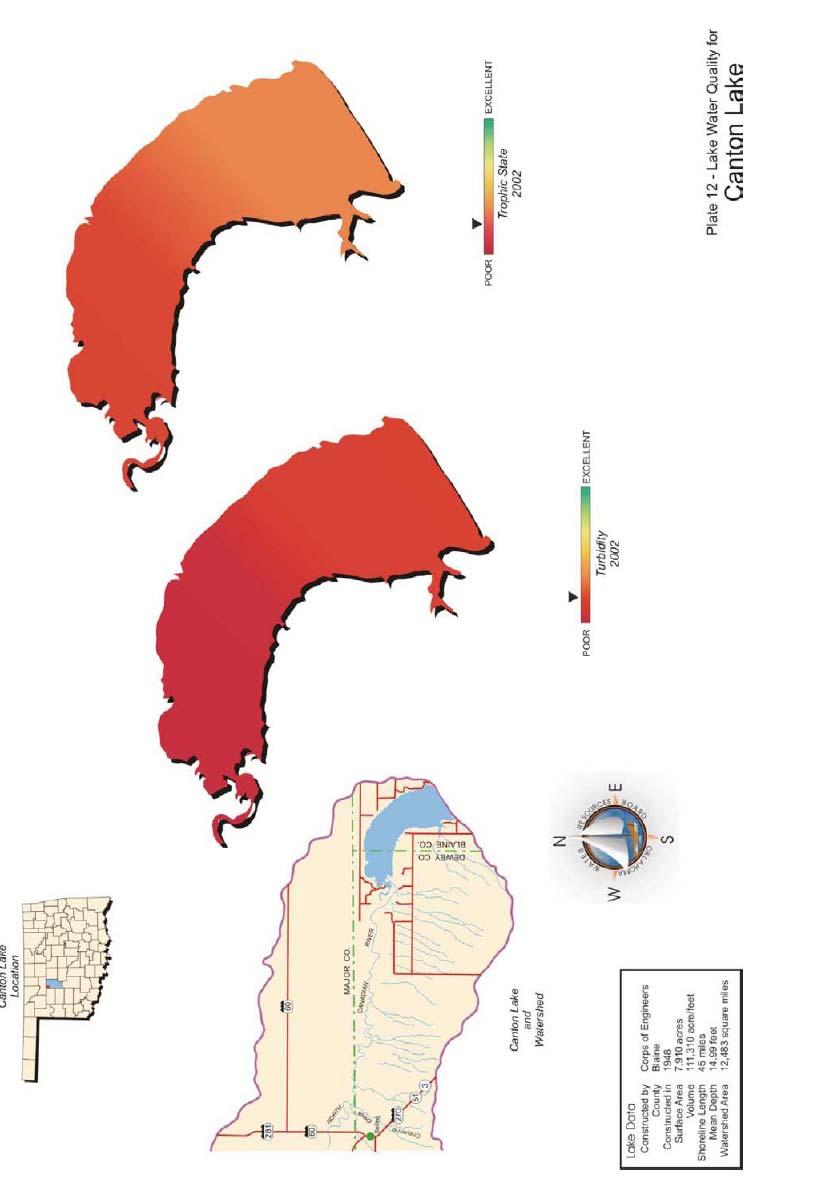
2 Canton Lake Management Plan Physical Description Canton Lake, located in Blaine and Dewey Counties, covers 7,910 surface acres and was constructed in 1948 by the United States Army Corps of Engineers to serve as a flood control, water supply and irrigation reservoir. The lake also serves as a municipal water supply reservoir for the City of Oklahoma City, which pays to have water released from the lake for water supply purposes. Canton covers 7,910 acres at normal pool and has a storage capacity of 111,310 acre feet, the drainage area is 7,500 square miles. Canton Lake impounds the North Canadian River with an annual exchange rate of 9.4. The secchi disk reading in the main pool is around 25 inches. Canton has a mean depth of 15 feet and a maximum depth of 35 feet. There is 45 miles of shoreline with a shoreline development ratio of 6.4. Prevailing winds are from a southerly direction at 12 mph. Typical annual fluctuation is 4 feet. Water Quality OWRB conducted a BUMP study in 2006, water quality samples were collected at five sites to represent the riverine, transition and lacustrine zones of the reservoir. Water chemistry samples were collected from the lake surface at all sites during the study period. The lake-wide annual turbidity value was 16 NTU (Appendix chart A). Water clarity was average based on secchi disk depth, turbidity, and true color values (Appendix chart B) and results for these parameters were similar to that in 2004, indicative of high primary productivity and nutrient rich conditions. This is similar to previous data collected efforts, indicating no significant change in productivity has occurred. The TSI values throughout the sample year were fairly consistent with hypereutrophic conditions in the fall and eutrophic conditions observed the remaining three sampling intervals. The only exception to this occurred at sites 1 and 2, which were mesotrophic in the summer. Turbidity values ranged from low of 7 NTU to a maximum of 40 NTU, with the highest values recorded at site 4 in the upper end of the reservoir (Appendix chart A). Vertical profiles for dissolved oxygen, ph, temperature, specific conductivity and salinity were recorded at all sample sites during the study period. Salinity values ranged from 0.63 parts per thousand (ppt) in the winter to 0.93 ppt in the summer. Salinity concentrations were consistently higher than the range of expected values 1
3 for Oklahoma lakes, reflecting the moderate to high presence of chlorides or other salts in the lake. Specific conductivity values were also higher than the expected range for Oklahoma reservoirs, indicating a high level of electrical current conducting compounds (i.e salts). Values ranted from 1201 µs/cm in the winter to 1743 µs/cm in the summer. Lake ph values were neutral to moderately alkaline, ranging from 7.51 to 8.49 units. The lake was not stratified during the fall, winter or spring quarters (Appendix chart C, D & E). Thermal stratification was present in 25% of the water column in the summer. Stratification occurred between 12 & 15 feet below the surface with dissolved oxygen (D.O.) dropping below 2.0 mg/l from 18 feet to the lake bottom of 21 feet (Appendix chart F). In previous evaluations there has been an absence of stratification for the entire sample year, which may be attributed to its fairly shallow nature and high prevailing winds. Bacteriological samples were also collected to assess the Primary Body Contact Recreation (PBRC) beneficial use. Samples were collected at five sites for E.coli, fecal coliform, and enterococci during the recreation season of May through September. All sample results were below both screening level and geometric mean, therefore the PBCR beneficial use is considered fully supported. Water quality samples were analyzed for nutrients including total nitrogen and total phosphorus. The lake-wide total nitrogen (TN) was 0.78 mg/l at the lake surface in sample year The epilimnetic (surface) TN ranged from 0.63 mg/l to 1.03 mg/l. TN was highest at site 5 in the fall. The lake-wide total phosphorus (TP) average was mg/l at the lake surface. The TP ranged from mg/l to mg/l at the surface. Similar to TN, the highest TP was reported both in the fall with the lowest values reported during the summer quarter. The nitrogen to phosphorus ration (TN:TP) was approximate 13:1 for sample year The value is greater than 7:1, characterizing the lake as phosphorus limited (Wetzel, 1983). The Oklahoma Department of Environmental Quality (ODEQ) sampled the lake in 1999 as part of their Toxics Monitoring Program and detected no compounds at the ODEQ screening level of consumption advisory level. The lake is fully supporting its Fish Consumption beneficial use. Canton Lake was also sampled for total metals at five sites during the spring of Results of sampling showed the lake to be fully supporting its FWP beneficial use based on toxic (metals) compounds in the water column. 2
4 Habitat Fish habitat consists primarily of rip-rap along the dam, Canadian and Big Bend camping areas and some aquatic vegetation and flooded timber in the upper part of the lake. Habitat is lacking and numerous man-made fish attractors have been added consisting mainly of cedar brush piles. These brush piles are located: Along the dam at: N W N W N W N W N W N W N W Cantonment Point: N W Canadian Park area N W N W N W N W Red Bluff Cove: N W Indian Cove: N W N W N W N W All brush piles are accessible from the bank. Habitat plans in the future include recharging existing brush piles making new brush piles and the introduction of aquatic vegetation such as water willow. Fisheries History Popular sport fish found in Canton include walleye, white bass, hybrid striped bass, crappie, and channel catfish. A healthy flathead catfish population exists with high recruitment and individuals reaching 60 pounds. A history of the largemouth bass population shows a low density with poor recruitment due to lack of shoreline cover and fluctuating water levels. Current regulations include an 18-inch minimum limit for walleye and a 20 fish per day aggregate limit for white bass and 3
5 hybrid striped bass of which only five may be 20-inches or greater. An annual tournament, Walleye Rodeo, has been held in May for 41 years. This is the largest fishing event in Oklahoma and tends to be family oriented. Walleye were first stocked in Canton during the 1950s. The introduction was very successful and Canton remains a premier walleye fishery. The majority of saugeye and walleye fingerlings stocked annually across the state come from Canton walleye brood stock. An 18-inch minimum length limit was initiated in Canton s walleye population has benefited from this regulation. Benefits are seen in annual egg collection, with a higher catch rate of spawning size females being collected. A comparison of fall gill net catch rates is shown in (Figure 1.). Total catch rate and catch rates by length groups have varied but overall catch rates have met or exceeded statewide averages. Relative weight values (W r ) are shown in (Figure 2.). The W r values have been fair to acceptable for all length groups. Age and growth data were collected during 2001 and a FAST model indicated that walleye were reaching 18-inches in three years.(figure 3). Sexual maturity also occurs at three years. The walleye population is maintained by annual fry stockings (Table 1). From 1969 to 1973, walleye were not stocked and the population density dropped. Natural recruitment cannot support the population. Figure Walleye C/f Numbers in parenthesis represent acceptable C/f values for a quality fishery Effort equals 5 net nights total (>2.4) 12 in.( 1.4) in.( 0.5) >16 in.( 0.5) C/f Year 4
6 Figure 2. Walleye Wr Acceptable Wr values are >90 Effort equals 5 net nights <12 in in. >16 in Wr Year Figure 3. Walleye age & growth length (in.) age 5
7 White bass were introduced into Canton from an unkown source in The white bass population is very healthy with good to excellent recruitment annually. April spawning runs in the North Canadian River attract anglers from across the state. Summer vertical slabbing also attributes for some outstanding catches. Fall gill net catch rate data (Figure 4.) indicates total catch and catch by length groups to meet or exceed state wide averages. The W r values for fish > 12-inches have been below acceptable values from 1999 to 2006 (Figure 5.). W r improved in The Canton white bass population is one of the main sources for hybrid striped bass and reciprocal hatchery production. Annually, approximately 250 male and 50 female white bass brooders are harvested for hatchery production. Figure 4. White Bass C/f Effort equals 5 net nights total < > C/f Year 6
8 Figure5. White bass Wr Acceptable Wr values are >90 Effort equals 5 net nights <8 IN in. >12 in Wr year Hybrid striped bass were first introduced into Canton in Annual fingerling stockings (Table 1.) have produced a satifactory fishery with trophy fish in excess of 20 pounds being harvested. Table 1. Species, number and size of fish stocked in Lake Canton, DATE SPECIES NUMBER SIZE(IN) 1984 Hybrid Striped Bass 805,200 Fry Hybrid Striped Bass 2,025 Fingerling Northern Largemouth Bass 130,000 Fingerling Walleye 3,318,374 Fry 1985 Hybrid Striped Bass 12,650 Fingerling Walleye 3,234,430 Fry 1986 Hybrid Striped Bass 79,260 Fingerling Walleye 3,249,333 Fry 7
9 DATE SPECIES NUMBER SIZE(IN) 1987 Hybrid Striped Bass 127,546 Fingerling Walleye 2,167,000 Fry 1988 Walleye 3,210,000 Fry 1989 Blue Catfish 74,889 Fingerling Walleye 7,819,300 Fry 1990 Hybrid Striped Bass 78,840 Fingerling Walleye 3,451,000 Fry Blue Catfish 21,717 Fingerling Hybrid Striped Bass 36,500 Fingerling Walleye 1,535,000 Fry Blue Catfish 27,200 Fingerling Channel Catfish 59,296 Fingerling Hybrid Striped Bass 76,000 Fingerling Walleye 5,890,000 Fry 1993 Blue Catfish 89 ADULT Hybrid Striped Bass 74,250 Fingerling Walleye 8,766,260 Fry 1994 Hybrid Striped Bass 48,380 Fingerling Walleye 5,668,475 Fry 1995 Hybrid Striped Bass 80,000 Fingerling Walleye 5,020,000 Fry 1996 Hybrid Striped Bass 32,000 Fingerling Walleye 7,132,000 Fry 1997 Hybrid Striped Bass 70,000 Fingerling Walleye 5,300,000 Fry Walleye 17 ADULT 1998 Hybrid Striped Bass 500,000 Fry Hybrid Striped Bass 72,600 Fingerling 8
10 DATE SPECIES NUMBER SIZE(IN) Walleye 3,800,000 Fry 1999 Hybrid Striped Bass 80,000 Fingerling Walleye 5,150,000 Fry 2000 Hybrid Striped Bass 73,000 Fingerling Walleye 3,657,994 Fry 2001 Hybrid Striped Bass 72,800 Fry Smallmouth Bass 160 Sub-Adult Walleye 4,914,270 Fry 2002 Hybrid Striped Bass 73,770 Fingerling Walleye 4,367,600 Fry 2003 Hybrid Striped Bass 73,610 Fingerling Striped Bass 4,900 Fingerling Walleye 5,000,000 Fry 2004 Hybrid Striped Bass 80,650 Fingerling Walleye 5,895,500 Fry 2005 Hybrid Striped Bass 73,167 Fingerling Walleye 3,891,449 Fry 2006 Hybrid Striped Bass 1,900 Fingerling Walleye 3,691,142 Fry 2007 Blue Catfish 163 Sub-Adult Hybrid Striped Bass 70,418 Fingerling Striped Bass 1,963 Fingerling Walleye 1,900,000 Fry 2008 Walleye 3,930,000 Fry Hybrid Striped Bass 36,778 Fingerling Catch rates have been highly variable with satisfactory numbers of catchable size ( inch) hybrids and low to acceptable rates of trophy fish (Figure 6.). Decreases in the catch rates for years 1993, 1996, 2000 and 2004 corresponds to 9
11 low catch rates of forage size gizzard shad. Relative weight values have remained below the acceptable value > 90 for all size groups of the population (Figure 7.). Figure 6. Striped bass X white bass hybrid C/f Numbers in parentheses represent acceptable C/f values for a quality fishery Effort equals 5 net nights 18 total ( 2.4) <11.9 in. ( 0.7) in. ( 1.2) >20 in. ( 0>48) C/f Year 10
12 Figure 7. Striped bass x white bass hybrids Wr Acceptable Wr values are >90 Effort equals 5 net nights <11.9 in in.. 20 in Wr year The channel catfish population continues to produce a very stable fishery. Anglers pursue channel catfish with trotlines, juglines, shoreline rod and reel, and drift fishing. Catch rates remain higher than the state average and trophy channel catfish are routinely harvested (Figure 8.). Channel catfish relative weight values vary from fair to acceptable (Figure 9.). Decreases in relative weight of all major predatory species during the last ten years appears to be related to low catch rates of forage size gizzard shad. 11
13 Figure 8. Channel catfish C/f Numbers in parenthesis represent acceptable C/f values for a quality fishery Effort equals 5 net nights Total ( 4.8) <12 in.( 2.4) >12 in.( 2.4) >16 in ( 1.2) C/f year Figure 9. Channel catfish Wr Acceptable Wr values are >90 Effort equals 5 net nights <12 in. 12 in 16 in Wr year 12
14 Flathead catfish were sampled by summer electrofishing from to 1993 to obtain data for a proposed statewide length limit (Figure 10.). Recruitment appeared acceptable with trophy size fish available for harvest. Figure 10. Flathead catfish C/f C/f 100 f total <12 in. 12 in. 20 in. 24 in. 28 in. size group Crappie were sampled by trap netting from 1990 through 1993 to assess the population (Figure 11.). The white crappie demonstrated good growth by reaching 9.3-inches at Age I+. Rapid growth accounted for the high percentage of crappie over 10-inches (27%). Only 3.8 percent of the sample were Age III fish or older (Figure 12). The absence of older fish may have been related to harvest. Crappie angling remains good at Canton; further action will only be taken if there is a need from the angling public. 13
15 Figure 11. Crappie C/f Numbers in parenthesis represent acceptable C/f values for a quality fishery C/f total ( 25) <5 in.( 5) 5 in.(10-40) 8 in.( 10) 10 in.( 4) size group Figure 12. Crappie Age and Growth Length in Inches age 0 age1 age 2 age 3 Years 14
16 Largemouth bass were sampled by spring electrofishing from 1978 through Lack of shoreline cover and flucuating water levels attributed to very low abundance. A quota of 250 largemouth bass was almost impossible to obtain. More stable spring water levels, habitat improvement, and the spread of native vegetation beds have caused this population to rebound. Future spring electrofishing may occur based on public input. Canton received one fish transfer of 160 lake strain smallmouth bass in 2001 from Lake Lawtonka. Fish have shown excellent growth with individuals in excess of four pounds being harvested by anglers. In March 2009, a new lake record was established with a five pound smallmouth harvested. Recruitment has never been verified. Fall night electrofishing may occur in the future to sample for recruitment. Gizzard shad is the primary forage fish at Canton. Catch rates greatly exceed the state average of 4.8 (Figure 13.). Catch rates of gizzard shad less than 8-inches were also high. Future sampling will include floating shad nets. Figure 13. Gizzard Shad C/f Numbers in parenthesis represent acceptable C/f values for a quality fishery total ( 4.8) <8 in.( 2.4) C/f Year 15
17 Canton was selected as our pilot lake for the Lake Records Program. Weight station is located at the Canton Motel, 223 W. Main in Canton. Current lake records are: Smallmouth bass 5.0 lbs. Flathead catfish 45.0 lbs. Channel catfish 34.0 lbs. Walleye 9.3 lbs. Striped bass hybrid 23.2 lbs. (2 oz. off state record) Largemouth bass 7.4 lbs. Sunfishes 2.7 lbs. Threats To The Fisheries A new threat to Canton s fishery came about in the mid-1990s. Confined swine production facilities proliferated in the Chester/Fairview area. Waste water is washed into plastic-lined sewage lagoons. From there, the water is used to irrigate five quarter sections of bermuda grass for a cow/calf operation. Sandy loam is the dominant soil type in the area with a percolation rate of one foot per hour. Ground water is 18 feet below the surface. This rapid percolation rate and close proximity of ground water allows for the transfer of nitrogen and phosphorus compounds into a ground water source that enters as surface water at Red Bluff Slough. In 1996, the Natural Resources, Wildlife, and Law Enforcement Divisions of the Oklahoma Department of Wildlife Conservation, along with private land owners, drilled several test wells in the area and started monitoring nutrient levels. This study resulted in formation of the Canton WMA Monitoring Program document. During the study period, February through November, an average of the test well samples indicated increases in nitrite-nitrate as N from 5.1 mg/liter to 6.1 mg/liter and phosphorous, total P from mg/liter to mg/liter. The Environmental Protection Agency assumed responsibility for sampling and reporting in This is an ongoing study with the most recent report done in Readings as high as 119 mg/liter NO 3 (N) were recorded from one site during April sampling. Red Bluff Slough is a 26 acre oxbow located northwest of Canton Reservoir. During times of high water, river flow reaches Red Bluff Slough and connects with Canton Reservoir. Red Bluff Slough has massive beds of cattail, coontail, and American pond weed that may act as a biological sponge for the swine waste nutrients. However, the threat to water quality exists and appears to be increasing. 16
18 Another threat to the fishery is domestic use by Oklahoma City. Oklahoma City owns the water rights and demands have been extreme in the past during drought years. In the past, water levels have been dropped in excess of 11 feet for Oklahoma City s needs. These releases have been very detrimental to shoreline fish species reproduction. The Canton Lake Advisory Committee formed in Members consist of the United States Corps of Engineers, Oklahoma Department of Wildlife Conservation, Canton Lake Association, Hefner Lake Association, and the Oklahoma Water Resources Board. After meeting for two years, an informal agreement was made that upon Oklahoma City making a water release request, the committee would meet to discuss the amount of release and timing. The maximum release would not drop the water level more than four feet during one release. Spring releases would be avoided to allow shoreline fish species the opportunity to spawn. Since this informal agreement has been completed, water levels have become more stable and shoreline fish species have rebounded or expanded. Invasive nuisance species found near Canton include zebra mussel veligers at Foss Lake. Canton s salt concentration would make it a candidate for golden algae. Management Goals All species Determine angler satisfaction and desires, catch rate and harvest of sportfish species. Walleye Continue annual fry stockings and continue to monitor the population by fall gillnetting. Hybrid striped bass Continue annual fingerling stockings and continue to monitor population by fall gillnetting. Forage sampling Starting in September 2009, floating shad net sampling will start. Perhaps this sampling gear will give more accurate data. 17
19 Management Objectives Management objectives are to continue fish stockings. Walleye fry (3 day old) should be stocked annually at a rate 405/acre=3,200,000. Natural reproduction cannot maintain this population. Hybrid striped bass fingerlings (1.5 inches) should be stocked annually at a rate of 38/acre=72,000. Previous stockings have produced a trophy size hybrid fishery. A fall gillnet survey should be conducted annually to monitor open water predators and the gizzard shad population and collect age and growth data on high priority species. Otoliths will be pulled from walleye and hybrid striped bass for age and growth analysis. A four year previous trap net study showed that the crappie population would benefit from a 10-inch minimum length limit. However; the angling public strongly opposed it. Should changes in the population occur or anglers become dissatisfied, future trap net sampling may be necessary. No aquatic nuisance species have been found in Canton. Precautions will be made to ensure not to introduce any in the future. There are 7 boat ramps built and maintained by the Corps of Engineers along with numerous fishing jetties and shoreline access to the lake. 18
20 Appendix 19
21 20
CARL BLACKWELL LAKE MANAGEMENT PLAN
 CARL BLACKWELL LAKE MANAGEMENT PLAN Background Lake Carl Blackwell impounds Stillwater Creek, 10 miles west of Stillwater in Payne County, Oklahoma (Figure 1). The lake covers 3,370 surface acres and was
SKIATOOK LAKE MANAGEMENT PLAN
 SKIATOOK LAKE MANAGEMENT PLAN Background Skiatook Lake impounds Hominy Creek, 5 miles west of Skiatook in Osage County, Oklahoma (Figure 1). Skiatook Lake covers 10,540 surface acres and was constructed
SOONER LAKE MANAGEMENT PLAN
 SOONER LAKE MANAGEMENT PLAN Background Lake Sooner impounds Greasy Creek, 15 miles south of Ponca City in Noble and Pawnee Counties, Oklahoma (Figure 1). The Grease Creek basin that Sooner Lake impounds
DRIPPING SPRINGS LAKE 5 YEAR LAKE MANAGEMENT PLAN
 DRIPPING SPRINGS LAKE 5 YEAR LAKE MANAGEMENT PLAN FISHERIES DIVISION CENTRAL REGION OKLAHOMA DEPTMENT OF WILDLIFE CONSERVATION PREPARED BY: DANNY BOWEN OCTOBER 2013 1 Background Dripping Springs Lake impounds
Lake Murray Fisheries Management Plan
 Lake Murray Fisheries Management Plan Southcentral Region Oklahoma Department of Wildlife Conservation Prepared by: Cliff Sager, Fisheries Biologist David Routledge, Fisheries Technician Matt Mauck, Region
LAKE DIANE Hillsdale County (T8-9S, R3W, Sections 34, 3, 4) Surveyed May Jeffrey J. Braunscheidel
 Surveyed May Jeffrey J. Braunscheidel") Michigan Department of Natural Resources Status of the Fishery Resource Report No. 2003-4, 2003 LAKE DIANE Hillsdale County (T8-9S, R3W, Sections 34, 3, 4) Surveyed May 2001 Jeffrey J. Braunscheidel Environment
Michigan Department of Natural Resources Status of the Fishery Resource Report No. 2003-4, 2003 LAKE DIANE Hillsdale County (T8-9S, R3W, Sections 34, 3, 4) Surveyed May 2001 Jeffrey J. Braunscheidel Environment
JadEco, LLC PO BOX 445 Shannon, IL 61078
 Introduction: With the assistance of Lake Holiday staff and volunteers, we were able to conduct an AC electrofishing survey on May 8, 27. Water temperatures were 2.3 C (8.5 F) and water clarity was decent
Introduction: JadEco, LLC PO BOX 445 Shannon, IL 61078
 Introduction: was contacted to collected data on the fishery for Lake Holiday. AC Electroshocking was conducted at 2 locations on September 28, 2015. Fish population data was collected for a total of 100
Regulations. Grabbling season May 1 July 15; only wooden structures allowed.
 Enid Reservoir 218 REEL FACTS Keith Meals, Arthur Dunn, Stanley Turner Fisheries Biologists keithm@mdwfp.state.ms.us, ArthurD@mdwfp.state.ms.us, StanleyT@mdwfp.state.ms.us General Information: Enid Reservoir
MIDDLE FORK RESERVOIR Wayne County 2004 Fish Management Report. Christopher C. Long Assistant Fisheries Biologist
 MIDDLE FORK RESERVOIR Wayne County 2004 Fish Management Report Christopher C. Long Assistant Fisheries Biologist FISHERIES SECTION INDIANA DEPARTMENT OF NATURAL RESOURCES DIVISION OF FISH AND WILDLIFE
NURSERY POND Fish Management Report. Jason C. Doll Assistant Fisheries Biologist
 NURSERY POND 2004 Fish Management Report Jason C. Doll Assistant Fisheries Biologist FISHERIES SECTION INDIANA DEPARTMENT OF NATURAL RESOURCES DIVISION OF FISH AND WILDLIFE I.G.C. South, Room W273 402
TABLE ROCK LAKE 2014 ANNUAL LAKE REPORT. Shane Bush Fisheries Management Biologist Missouri Department of Conservation Southwest Region
 TABLE ROCK LAKE 14 ANNUAL LAKE REPORT Shane Bush Fisheries Management Biologist Missouri Department of Conservation Southwest Region March 1, 15 EXECUTIVE SUMMARY Table Rock Lake is a 43,1 acre reservoir
Regulations. Grabbling season May 1 July 15; only wooden structures allowed.
 Sardis Reservoir 218 REEL FACTS Keith Meals, Arthur Dunn, Stanley Turner Fisheries Biologists keithm@mdwfp.state.ms.us, ArthurD@mdwfp.state.ms.us, StanleyT@mdwfp.state.ms.us General Information: Sardis
Ross Barnett Reservoir 2019
 Ross Barnett Reservoir 19 Reel Facts Ryan Jones Fisheries Biologist Ryan.Jones@wfp.ms.gov (1) 89-31 General Information: Ross Barnett Reservoir is a 33, acre impoundment of the Pearl River. It consists
Regulations. Grabbling season May 1 July 15; only wooden structures allowed.
 Grenada Reservoir 218 REEL FACTS Keith Meals, Arthur Dunn, Stanley Turner Fisheries Biologists keithm@mdwfp.state.ms.us, ArthurD@mdwfp.state.ms.us, StanleyT@mdwfp.state.ms.us General Information: Grenada
Regulations. Grabbling season May 1 July 15; only wooden structures allowed.
 Arkabutla Reservoir 219 REEL FACTS Keith Meals, Arthur Dunn, Stanley Turner Fisheries Biologists keithm@wfp.ms.gov, ArthurD@wfp.ms.gov, StanleyT@wfp.ms.gov General Information: Arkabutla Reservoir is one
Pickwick Lake 2018 REEL FACTS Trevor Knight Fisheries Biologist (662)
") Pickwick Lake 218 REEL FACTS Trevor Knight Fisheries Biologist trevork@mdwfp.state.ms.us (662) 84-5176 General Information: Covering 43,1 acres, Pickwick Lake, which borders Alabama, Tennessee, and Mississippi,
Pickwick Lake 218 REEL FACTS Trevor Knight Fisheries Biologist trevork@mdwfp.state.ms.us (662) 84-5176 General Information: Covering 43,1 acres, Pickwick Lake, which borders Alabama, Tennessee, and Mississippi,
Spring Lake 2017 REEL FACTS Keith Meals Fisheries Biologist
 Spring Lake 217 REEL FACTS Keith Meals Fisheries Biologist keithm@mdwfp.state.ms.us General Information: Spring Lake is a clear, shallow 6 acre spring-fed impoundment in Wall Doxey State Park. Nearly half
Overview of Recreational Pond Management
 Overview of Recreational Pond Management extension November 13 th 2013 Forrest Wynne State Extension Specialist for Aquaculture Kentucky State University Ponds are built for some of the following purposes:
Ross Barnett Reservoir 2018
 Ross Barnett Reservoir 18 Reel Facts Ryan Jones Fisheries Biologist Ryanj@mdwfp.state.ms.us (61) 89-341 General Information: Ross Barnett Reservoir is a 33, acre impoundment of the Pearl River. It consists
Green Lake Population Survey
 Located next to the Green Lake Aquatic Center in Calumet City on the north side of 159 th St, east of Torrence Ave. Size can be deceiving; this 5 acre lake is the deepest lake in the District with a maximum
Arrowhead Lake Population Survey
 Located in Palos Heights at 135 th St, east of Harlem Ave. Arrowhead Lake is a 13 acre body of water with a maximum depth of 12.6 feet. Fish species found in this lake include largemouth bass, bluegill,
Regulations. Grabbling season May 1 July 15; only wooden structures allowed.
 Sardis Reservoir 19 REEL FACTS Keith Meals, Arthur Dunn, Stanley Turner Fisheries Biologists keithm@wfp.ms.gov, ArthurD@wfp.ms.gov, StanleyT@wfp.ms.gov General Information: Sardis Reservoir is one of four
Broken Bow Lake Management Plan
 Broken Bow Lake Management Plan Background Broken Bow Lake is located approximately 9 miles north of the town of Broken Bow in McCurtain county, southeast Oklahoma (Figure 1). The lake is operated by the
NEVADA DEPARTMENT OF WILDLIFE STATEWIDE FISHERIES MANAGEMENT
 NEVADA DEPARTMENT OF WILDLIFE STATEWIDE FISHERIES MANAGEMENT FEDERAL AID JOB PROGRESS REPORTS F-2-52 216 CHIMNEY RESERVOIR WESTERN REGION NEVADA DEPARTMENT OF WILDLIFE, FISHERIES DIVISION JOB PROGRESS
NEVADA DEPARTMENT OF WILDLIFE STATEWIDE FISHERIES MANAGEMENT
 NEVADA DEPARTMENT OF WILDLIFE STATEWIDE FISHERIES MANAGEMENT FEDERAL AID JOB PROGRESS REPORTS F-20-48 2012 RYE PATCH RESERVOIR WESTERN REGION NEVADA DEPARTMENT OF WILDLIFE, FISHERIES DIVISION JOB PROGRESS
Schiller Pond Population Survey
 Located in the town of Schiller Park on Irving Park Rd. just west of Cumberland Ave. This small 6 acre pond has a maximum depth of 6.3 feet. In addition to largemouth bass and bluegill, Schiller Pond is
Busse Reservoir South Lateral Pool Population Survey
 Busse Reservoir South Lateral Pool Survey Located in Elk Grove Village south of Higgins Rd. between RT 53/I-290 and Arlington Heights Rd. Busse Reservoir is comprised of three pools making up a total of
Maple Lake Population Survey
 Maple Lake Survey Located in Willow Springs approximately 1 mile west of Willow Springs Rd. (104 th Ave.) at Wolf Rd. and 95 th St. Constructed in the 1920 s this 60 acre lake drops down to 20.4 feet in
PRODUCING A TROPHY LARGEMOUTH BASS FISHERY (CASE STUDY) Greg Grimes President of Aquatic Environmental Services, Inc.
 Greg Grimes President of Aquatic Environmental Services, Inc.") PRODUCING A TROPHY LARGEMOUTH BASS FISHERY (CASE STUDY) Greg Grimes President of Aquatic Environmental Services, Inc. Background 32 acre lake in Harris County, Georgia o The construction of the lake began
PRODUCING A TROPHY LARGEMOUTH BASS FISHERY (CASE STUDY) Greg Grimes President of Aquatic Environmental Services, Inc. Background 32 acre lake in Harris County, Georgia o The construction of the lake began
Alcona Dam Pond Alcona County (T25N, R5E, Sections various) Surveyed June 6-12 and September 16, 2003
 Surveyed June 6-12 and September 16, 2003") Michigan Department of Natural Resources Status of the Fishery Resource Report No. 2004-6, Year 2004 Alcona Dam Pond Alcona County (T25N, R5E, Sections various) Surveyed June 6-12 and September 16, 2003
Michigan Department of Natural Resources Status of the Fishery Resource Report No. 2004-6, Year 2004 Alcona Dam Pond Alcona County (T25N, R5E, Sections various) Surveyed June 6-12 and September 16, 2003
MIDDLE FORK RESERVOIR Wayne County 2006 Fish Management Report. Christopher C. Long Assistant Fisheries Biologist
 MIDDLE FORK RESERVOIR Wayne County 2006 Fish Management Report Christopher C. Long Assistant Fisheries Biologist Fisheries Section Indiana Department of Natural Resources Division of Fish and Wildlife
2014 Island Lake Survey June 13 th, 2014 Andrew Plauck District Fisheries Biologist Report Prepared 4 March 2015
 2014 Island Lake Survey June 13 th, 2014 Andrew Plauck District Fisheries Biologist Report Prepared 4 March 2015 BACKGROUND - A fish survey was requested due to a moderately severe winterkill in Island
MARTINDALE POND Wayne County 2004 Fish Management Report. Christopher C. Long Assistant Fisheries Biologist
 MARTINDALE POND Wayne County 2004 Fish Management Report Christopher C. Long Assistant Fisheries Biologist Fisheries Section Indiana Department of Natural Resources Division of Fish and Wildlife I.G.C.
Tunica Cutoff 2018 REEL FACTS Keith Meals Fisheries Biologist
 Tunica Cutoff 218 REEL FACTS Keith Meals Fisheries Biologist keithm@mdwfp.state.ms.us General Information: Tunica Cutoff was created by the US Army Corps of Engineers (COE) in 1942 when a bend in the Mississippi
Quemahoning Reservoir
 Pennsylvania Fish & Boat Commission Biologist Report Quemahoning Reservoir Somerset County May 2011 Trap Net, Gill Net and Electrofishing Survey Quemahoning Reservoir is an 899 acre impoundment located
Keystone Lakes November 20, 2014
 FISH SURVEY REPORT Keystone Lakes November 20, 2014 Prepared for: Keystone HOA 6231 Shoreham Drive Evansville, IN 47711 Prepared by: Aquatic Control Inc. P.O. Box 100 Seymour, IN 47274 November 2015 -
LAKE ELLSWORTH 5-YEAR FISHERIES MANAGEMENT PLAN SOUTHWEST REGION OKLAHOMA DEPARTMENT OF WILDLIFE CONSERVATION
 LAKE ELLSWORTH 5-YEAR FISHERIES MANAGEMENT PLAN SOUTHWEST REGION OKLAHOMA DEPARTMENT OF WILDLIFE CONSERVATION Prepared by: Larry Cofer, Regional Fisheries Supervisor Ryan Ryswyk, Fisheries Biologist John
Lake Seminole. and Waters Bordering Georgia and Alabama
 Lake Seminole and Waters Bordering Georgia and Alabama LAKE SEMINOLE Site Description Lake Seminole is a 37,500-acre reservoir located at the juncture of the Florida, Georgia, and Alabama state lines.
INLAND LAKE MANAGEMENT REPORT FY Spring 2008
 INLAND LAKE MANAGEMENT REPORT FY 2008 Spring 2008 Prepared by Robert O. Andress District Fisheries Biologist E. Daniel Catchings District Fisheries Supervisor Kevin W. Baswell District Biologist Aide Department
Rolling Knolls Pond Population Survey
 Located near the town of Elgin on the west side of Rohrssen Rd. between Illinois Route 58 and U.S.- 20. This small 1.8 acre pond has a maximum depth of 7.5 feet and is occasionally influenced by Poplar
An Assessment of the Fish Community in Lake Acworth
 An Assessment of the Fish Community in Lake Acworth By John Damer Fisheries Biologist Georgia Department of Natural Resources Wildlife Resources Division Fisheries Section Calhoun, GA 30701 July 2008 Introduction
Tampier Lake Population Survey
 Located in Palos Park on 131 st St. between Wolf and Will-Cook Rd. s. Tampier Lake has 131 acres of fishable water, with a maximum depth of 9.4 feet. Walleye, northern pike, largemouth bass and channel
Sag Quarry - West Population Survey
 Located in Lemont on RT 83 and Archer Ave. just north of 111 th St. Like Sag Quarry East, this lake is an old limestone quarry, 14 acres in size and with a maximum depth of 10.3 feet. The species found
Wampum Lake Population Survey
 Wampum Lake Survey Located in Thornton on Thornton-Lansing Rd. 1½ mile west of Torrence Ave. Wampum Lake is 35 acres is size and has a maximum depth of 14.1 feet. Northern pike, largemouth bass, bluegill,
NEVADA DEPARTMENT OF WILDLIFE STATEWIDE FISHERIES MANAGEMENT
 NEVADA DEPARTMENT OF WILDLIFE STATEWIDE FISHERIES MANAGEMENT FEDERAL AID JOB PROGRESS REPORTS F-20-52 2016 RYE PATCH RESERVOIR WESTERN REGION NEVADA DEPARTMENT OF WILDLIFE, FISHERIES DIVISION ANNUAL PROGRESS
2010 Fishing Opener Prognosis. Central Region
 2010 Fishing Opener Prognosis Central Region Hinckley PINE COUNTY Pokegama, Cross, Island, Oak and North and South Big Pine Lakes are typically the best lakes for targeting walleye in Pine County. They
7/29/2011. Sport fish. Rough fish. Fish Population Assessment
 Fish Population Assessment Sport fish Forage fish Rough fish 1 Question: How Do I Assess My Fish Population? Answer: Volkswagens to Corvettes!!! Volkswagen or Do-it-yourself Approach Keep catch records
Bode Lake - South Population Survey
 Bode Lake - South Survey Located in Hoffman Estates on the north side of Bode Rd. 1 mile west of Barrington Rd. Bode Lake is made up of two lakes along Poplar Creek; the larger and deeper Bode Lake South
NEVADA DEPARTMENT OF WILDLIFE STATEWIDE FISHERIES MANAGEMENT
 NEVADA DEPARTMENT OF WILDLIFE STATEWIDE FISHERIES MANAGEMENT FEDERAL AID JOB PROGRESS REPORTS F-2-49 213 RYE PATCH RESERVOIR WESTERN REGION NEVADA DEPARTMENT OF WILDLIFE, FISHERIES DIVISION ANNUAL PROGRESS
KICKAPOO LAKE Shakamak State Park Sullivan, Greene, and Clay Counties 2009 Fish Management Report. David S. Kittaka Fisheries Biologist
 KICKAPOO LAKE Shakamak State Park Sullivan, Greene, and Clay Counties 2009 Fish Management Report David S. Kittaka Fisheries Biologist Fisheries Section Indiana Department of Natural Resources Division
EUFAULA LAKE 5 YEAR LAKE MANAGEMENT PLAN
 EUFAULA LAKE 5 YEAR LAKE MANAGEMENT PLAN FISHERIES DIVISION CENTRAL REGION OKLAHOMA DEPTMENT OF WILDLIFE CONSERVATION PREPARED BY: DANNY BOWEN SEPTEMBER 15, 2008 1 Background Eufaula Lake is located on
LITTLE WHITE OAK Knox County 2006 Fish Management Report. Debbie King Assistant Fisheries Biologist
 LITTLE WHITE OAK Knox County 2006 Fish Management Report Debbie King Assistant Fisheries Biologist Fisheries Section Indiana Department of Natural Resources Division of Fish and Wildlife I.G.C.-South,
LOGAN MARTIN RESERVOIR MANAGEMENT REPORT. Prepared by. E. Daniel Catchings District Fisheries Supervisor
 LOGAN MARTIN RESERVOIR MANAGEMENT REPORT 2008 Prepared by E. Daniel Catchings District Fisheries Supervisor Robert O. Andress District Fisheries Biologist Department of Conservation and Natural Resources
Upper/Lower Owl Creek Reservoir
 Upper/Lower Owl Creek Reservoir Schuylkill County 2018 Largemouth Bass Survey Upper Owl Creek Reservoir and Lower Owl Creek Reservoir are 67-acre and 26-acre impoundments, respectively, created by two
Striped Bass and White Hybrid (x) Striped Bass Management and Fishing in Pennsylvania
 Striped Bass Management and Fishing in Pennsylvania") Striped Bass and White Hybrid (x) Striped Bass Management and Fishing in Pennsylvania Prepared by R. Lorantas, D. Kristine and C. Hobbs PFBC Warmwater Unit 2005 (stocking numbers updated after 2005) Goal:
Striped Bass and White Hybrid (x) Striped Bass Management and Fishing in Pennsylvania Prepared by R. Lorantas, D. Kristine and C. Hobbs PFBC Warmwater Unit 2005 (stocking numbers updated after 2005) Goal:
Cedar Lake Comprehensive Survey Report Steve Hogler and Steve Surendonk WDNR-Mishicot
 Cedar Lake- 2006 Comprehensive Survey Report Steve Hogler and Steve Surendonk WDNR-Mishicot ABSTRACT Cedar Lake is a 142 acre lake located in the southwest corner of Manitowoc County. It is a seepage lake
LAKE TANEYCOMO 2011 ANNUAL LAKE REPORT
 LAKE TANEYCOMO 211 ANNUAL LAKE REPORT Shane Bush Fisheries Management Biologist Missouri Department of Conservation Southwest Region March 1, 212 EXECUTIVE SUMMARY Lake Taneycomo was formed by the construction
Fish Lake Informational Meeting. Dan Wilfond, Fisheries Specialist Deserae Hendrickson, Area Fisheries Supervisor MN DNR Fisheries - Duluth
 Fish Lake Informational Meeting Dan Wilfond, Fisheries Specialist Deserae Hendrickson, Area Fisheries Supervisor MN DNR Fisheries - Duluth Why are we here tonight? Provide background info on fish community
Crooked Lake Oakland County (T4N, R9E, Sections 3, 4, 9) Surveyed May James T. Francis
 Surveyed May James T. Francis") Michigan Department of Natural Resources Status of the Fishery Resource Report No. 2004-1, 2004 Crooked Lake Oakland County (T4N, R9E, Sections 3, 4, 9) Surveyed May 2002 James T. Francis Environment Crooked
Michigan Department of Natural Resources Status of the Fishery Resource Report No. 2004-1, 2004 Crooked Lake Oakland County (T4N, R9E, Sections 3, 4, 9) Surveyed May 2002 James T. Francis Environment Crooked
Oologah Lake Management Plan
 Oologah Lake Management Plan Oklahoma Department of Wildlife Conservation 2008 1 Background Introduction When the Flood Control Act was passed on June 28, 1938 the Oologah Lake dam project was approved.
Crawford Reservoir. FISH SURVEY AND MANAGEMENT INFORMATION Eric Gardunio, Fish Biologist Montrose Service Center
 FISH SURVEY AND MANAGEMENT INFORMATION General Information: Crawford Reservoir is a popular fishery that provides angling opportunity for yellow perch, channel catfish, northern pike, rainbow trout, black
DOW# West Twin Lake
 DOW# 69-0696 West Twin Lake West Twin Lake has a surface area of 120.4 acres and is located on the east side of St. Louis County Road 31, south of Highway 2. West Twin Lake has a maximum depth of 18 feet
WISCONSIN DEPARTMENT OF NATURAL RESOURCES FISH MANAGEMENT ACTIVITIES DELAVAN LAKE SPRING 2012
 WISCONSIN DEPARTMENT OF NATURAL RESOURCES FISH MANAGEMENT ACTIVITIES DELAVAN LAKE SPRING 212 Electrofishing and fyke net surveys were conducted on Delavan Lake March 2-May 3, 212. Fyke netting and electrofishing
WAURIKA RESERVOIR 5-YEAR FISHERIES MANAGEMENT PLAN
 WAURIKA RESERVOIR 5-YEAR FISHERIES MANAGEMENT PLAN SOUTHWEST REGION OKLAHOMA DEPARTMENT OF WILDLIFE CONSERVATION Prepared by: Larry Cofer, Regional Fisheries Supervisor Ryan Ryswyk, Fisheries Biologist
Big Canyon 67 miles upstream. 38 miles upstream
 TEXOMA STRIPED BASS MANAGEMENT/RESEARCH Texoma is one of only about 1 reservoirs in the country that has a naturally reproducing striped bass population. Texoma is set off further from most reservoirs
BIG TWIN LAKE Kalkaska County (T28N, R05W, Section 18, and T28N, R06W, Section 13) Surveyed May 1999
 Surveyed May 1999") Michigan Department of Natural Resources Status of the Fishery Resource Report No. 2001-1, Year 2001 BIG TWIN LAKE Kalkaska County (T28N, R05W, Section 18, and T28N, R06W, Section 13) Surveyed May 1999
Michigan Department of Natural Resources Status of the Fishery Resource Report No. 2001-1, Year 2001 BIG TWIN LAKE Kalkaska County (T28N, R05W, Section 18, and T28N, R06W, Section 13) Surveyed May 1999
Current Status and Management Recommendations for the Fishery in the Cloverleaf Chain of Lakes
 Current Status and Management Recommendations for the Fishery in the Cloverleaf Chain of Lakes Jason Breeggemann Senior Fisheries Biologist Wisconsin Department of Natural Resources Outline DNR fisheries
LAKE TANEYCOMO 2012 ANNUAL LAKE REPORT. Shane Bush Fisheries Management Biologist Missouri Department of Conservation Southwest Region
 LAKE TANEYCOMO 12 ANNUAL LAKE REPORT Shane Bush Fisheries Management Biologist Missouri Department of Conservation Southwest Region March 1, 13 EXECUTIVE SUMMARY Lake Taneycomo was formed by the construction
Caro Impoundment, Tuscola County
 Caro Impoundment is a 200 acre impoundment of the Cass River located one mile south of the Village of Caro in Tuscola County. Caro Dam, originally constructed in 1906 for water supply to Michigan Sugar
Estimated on-the-ground start and end dates: 1 June October 2018
 A. Applicant Information Name of Organization: U.S. Army Corps of Engineers, Carlyle Lake 801 Lake Road, Carlyle, IL 62231 Contact Information: Robert Wilkins, Operations Manager, (618) 594-2484, Robert.Wilkins@usace.army.mil
Comprehensive Fisheries Survey of High Falls Reservoir, Marinette County Wisconsin during 2004 and Waterbody Identification Code
 Comprehensive Fisheries of High Falls Reservoir, Marinette County Wisconsin during 2004 and 2005 Waterbody Identification Code 540600 Justine Hasz Senior Fisheries Biologist Wisconsin Department of Natural
Pennsylvania Fish & Boat Commission Biologist Report. Wilmore Dam. Cambria County. May 2011 Trap Net, Electrofishing and Hoop Net Survey
 Pennsylvania Fish & Boat Commission Biologist Report Wilmore Dam Cambria County May 2011 Trap Net, Electrofishing and Hoop Net Survey Wilmore Dam is a 195 acre impoundment located in central Cambria County
Previous Stocking Black crappie. Channel catfish. Cutbow. Rainbow trout. Saugeye Black crappie. Channel catfish. Cutbow.
 Runyon Lake FISH SURVEY AND MANAGEMENT DATA Carrie Tucker - Aquatic Biologist (Pueblo) carrie.tucker@state.co.us / 719-561-5312 General Information: Runyon Lake, which is approximately thirty-five acres
RECREATIONAL PONDS AND LAKES
 RECREATIONAL PONDS AND LAKES POND ECOLOGY AQUATIC PLANTS & FISH F.S. Conte Department of Animal Science University of California Davis Photos By Flickr AQUATIC PLANTS POND HEALTH Chemical Recycling Oxygen
Previous Stocking 2012 Walleye Saugeye Cuttbow Walleye Saugeye Channel catfish Black crappie Bluegill Rainbow trout and Cuttbow
 General Information: is a 2,967 acre water (at full capacity). Anglers can expect quality fishing for wiper, walleye, saugeye, channel catfish, and rainbow trout. Please visit the state park website at:
Claytor Lake View of the Claytor Lake dam from Claytor Lake State Park s boat ramp.
 Claytor Lake 2007 Imagine yourself on a waterbody that is more like a wide river than a lake. When you do, you will have a picture of Claytor Lake. Claytor Lake, a 4,475-acre reservoir, stretches northeastward
MISSISSIPPI MAKEOVER A Plan for Restoration, Just Around the Bend
 MISSISSIPPI MAKEOVER A Plan for Restoration, Just Around the Bend Interim Report Card 2013 Project coordinated by the Dakota County Soil and Water Conservation District and sponsored by the Minnesota Pollution
Penny Road Pond Population Survey
 Located in Barrington Hills on the south side of Penny Rd. west of Old Sutton Rd. This small 7 acre pond has a maximum depth of 4.6 feet and is connected to Spring Creek. The fish population of Penny Road
NEVADA DEPARTMENT OF WILDLIFE STATEWIDE FISHERIES MANAGEMENT
 NEVADA DEPARTMENT OF WILDLIFE STATEWIDE FISHERIES MANAGEMENT FEDERAL AID JOB PROGRESS REPORTS F-20-52 2016 BOULDER RESERVOIR WESTERN REGION NEVADA DEPARTMENT OF WILDLIFE, FISHERIES DIVISION ANNUAL PROGRESS
Prewitt Reservoir LAST UPDATED: JANUARY 2016 FISH SURVEY AND MANAGEMENT DATA Mandi Brandt - Aquatic Biologist (Brush)
") General Information: is a 2,431 acre water (at full capacity) located on the State Wildlife Area. Anglers can expect quality fishing for walleye, saugeye, crappie, and channel catfish. Wiper can also be
General Information: is a 2,431 acre water (at full capacity) located on the State Wildlife Area. Anglers can expect quality fishing for walleye, saugeye, crappie, and channel catfish. Wiper can also be
Warmwater Fisheries Assessments 2014
 NJDEP Division of Fish and Wildlife Bureau of Freshwater Fisheries Warmwater Fisheries Assessments 2014 New Jersey has over 400 impoundments open to the general public for fishing and thousands more in
NEVADA DEPARTMENT OF WILDLIFE STATEWIDE FISHERIES MANAGEMENT
 NEVADA DEPARTMENT OF WILDLIFE STATEWIDE FISHERIES MANAGEMENT FEDERAL AID JOB PROGRESS REPORTS F-20-49 2013 SQUAW CREEK RESERVOIR WESTERN REGION Contents NEVADA DEPARTMENT OF WILDLIFE, FISHERIES DIVISION
Michigan Dept. of Natural Resources Status of the Fishery Resource Report Page 1. Weber Lake Cheboygan County, T34N, R3W, Sec.
 Michigan Dept. of Natural Resources 2012-143 Status of the Fishery Resource Report Page 1 Weber Lake Cheboygan County, T34N, R3W, Sec. 31 Neal Godby, Fisheries Biologist Environment Weber Lake is a 28.5-acre
NEVADA DEPARTMENT OF WILDLIFE STATEWIDE SPORT FISHERIES MANAGEMENT
 NEVADA DEPARTMENT OF WILDLIFE STATEWIDE SPORT FISHERIES MANAGEMENT FEDERAL AID JOB PROGRESS REPORT F-2-52 216 WILDHORSE RESERVOIR EASTERN REGION NEVADA DEPARTMENT OF WILDLIFE, FISHERIES DIVISION ANNUAL
REEL FACTS. Regulations. Limblines Fishing with limblines and set hooks is prohibited at Lake Washington.
 Lake Washington 19 REEL FACTS Nathan Aycock Fisheries Biologist NathanA@mdwfp.state.ms.us (61) 432-2 General Information: Lake Washington is a 3, acre oxbow lake of the Mississippi River. It is one of
Sebec Lake Fisheries Management Plan 2012
 Sebec Lake Fisheries Management Plan 2012 Sebec Lake is a 6,800-acre oligotrophic lake located in northwestern Maine. It has popular fisheries for landlocked salmon, lake trout, and smallmouth bass. Other
Big Bend Lake Population Survey
 Big Bend Lake Survey Located in Des Plaines on East River Rd. just south of Golf Rd. This 27 acre body of water has a depth of 27.8 feet; however because it is connected to the Des Plaines River by a spillway,
Status Review and Management Outline for Quality Bluegill and Black Crappie Populations in the Grand Rapids Area.
 Status Review and Management Outline for Quality Bluegill and Black Crappie Populations in the Grand Rapids Area. Revised in 2013 By David L. Weitzel Assistant Area Fisheries Supervisor MN DNR, Grand Rapids
Michigan Department of Natural Resources Status of the Fishery Resource Report Page 1
 Michigan Department of Natural Resources 2007-33 Status of the Fishery Resource Report Page 1 Grand Sable Lake Alger County, T49N, R14W, Sec. Many Lake Superior watershed, last year surveyed 2004 James
FISHERIES MANAGEMENT. Georgia Freshwater Fisheries. Department of Natural Resources Wildlife Resources Division
 FISHERIES MANAGEMENT Georgia Freshwater Fisheries Fishing in Georgia 1.4 million resident anglers fish in Georgia. Fishing in Georgia generates $1.3 billion in retail sales and a $2.1 billion ripple effect
I Region I Area I DOW Number / County I DOW Lake Name I Acreage I
 LAKE MANAGEMENT PLAN 814 Bp I Region I Area I DOW Number / County I DOW Lake Name I Acreage I I I # I f 2 Duluth F213 690036 St Louis Salo DOW:149 Plan: 137 Long Range Goal: Manage for walleye with a gillnet
Arizona Game and Fish Department Region VI Fisheries Program
 Arizona Game and Fish Department Region VI Fisheries Program Saguaro Lake Fish Survey Report April 18 th 21 st, 2016 Author: Bryant Dickens Report Date: July 7, 2016 The Arizona Game and Fish Department
LAKE MANAGEMENT PLAN
 LAKE MANAGEMENT PLAN Region 1 Area Park Rapids D.O.W. Number 29-185 County Hubbard D.O.W. Lake Name Big Sand Lake Class 22 Acreage 1,635 GIS 465 littoral LONG RANGE GOALS: Maintain or improve the quality
Inventory # Perch Lake
 Inventory # 9-036 Perch Lake Perch Lake is a double-basin lake. The southern, shallow portion of the lake is 414 acres, making it the largest wild rice lake on the Reservation. The fish communities sampled
FISH POPULATION ASSESSMENT AND INTERPRETATION FOR PRIVATE WATERS
 f - Tf~d5 CW$A~~:I~U: A%*---." - EXTENSION "e. ~ JAAv I J9.,m-i 56:~- Higginbotharn INTRODUCTION Many lakeowners request detailed technical assistance and services to enhance the quality of their sport
Kemper County Lake 2019 Reel Facts Trevor Knight Fisheries Biologist (662)
") Kemper County Lake 219 Reel Facts Trevor Knight Fisheries Biologist Trevor.Knight@wfp.ms.gov (662) 84-176 General Information: Kemper Lake is a 96 acre impoundment nestled in the hardwood hills of Kemper
Kemper County Lake 219 Reel Facts Trevor Knight Fisheries Biologist Trevor.Knight@wfp.ms.gov (662) 84-176 General Information: Kemper Lake is a 96 acre impoundment nestled in the hardwood hills of Kemper
Management Plan for the Obey River Trout Fishery
 Management Plan for the Obey River Trout Fishery 28-214 By: James Travis Scott Jack Swearengin Walter Scott Webb D.W. Young Tennessee Wildlife Resources Agency January 28 Management Plan for the Obey River
East Metro Forest Lake (2,251 acres): Coon Lake (1,481 acres):
: Coon Lake (1,481 acres):") East Metro Forest Lake (2,251 acres): Located within the City of Forest Lake and just east of Interstate 35, Forest Lake boasts good numbers of northern pike and walleye. Northern pike and walleye were
East Metro Forest Lake (2,251 acres): Located within the City of Forest Lake and just east of Interstate 35, Forest Lake boasts good numbers of northern pike and walleye. Northern pike and walleye were
2014 Winnebago System Walleye Report
 1986 1988 199 1992 1994 1996 1998 2 22 24 26 28 21 212 214 Number of YOY WAE / Trawl 214 Winnebago System Walleye Report Adam Nickel, Winnebago Gamefish Biologist, 18 March 215 The spring rush of 215 will