Conservation and Restoration Florida s Coastal Marshes: An Overview of MESS. Jeff Beal, Kent Smith, Erin McDevitt, Maria Merrill
|
|
|
- Brice Hutchinson
- 6 years ago
- Views:
Transcription
1 Conservation and Restoration Florida s Coastal Marshes: An Overview of MESS Jeff Beal, Kent Smith, Erin McDevitt, Maria Merrill

2 FWC s MESS: -Marine/Estuarine Subsection -within Aquatic Habitat Conservation and Restoration Section (Division of Habitat and Species) -Goal 1: Restore and enhance the quality and quantity of marine and estuarine habitats to benefit Florida s fish and wildlife populations -Goal 2: Conserve and maintain intact native estuarine and marine habitats and their ecological functions for the benefit of future generations of fish, wildlife, and people.
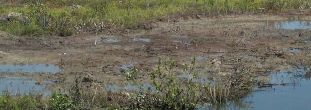
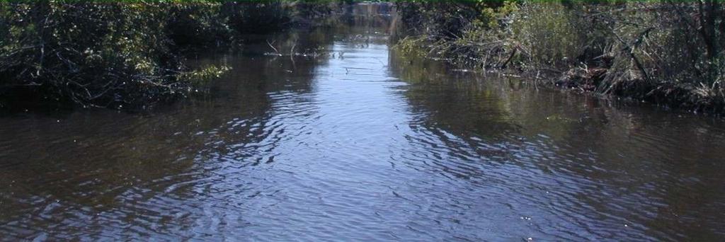
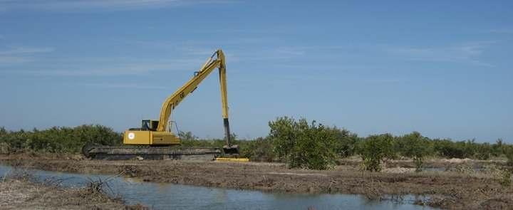
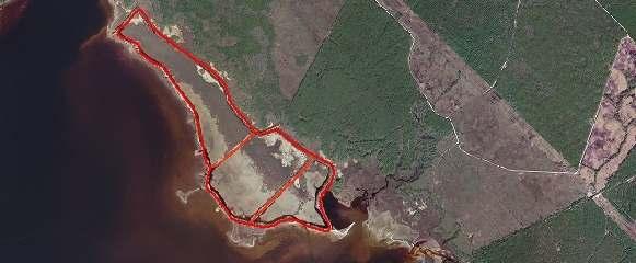
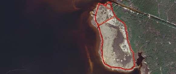
3 Dragline ditched saltmarsh restoration, Mosquito Lagoon
4 Mosquito Lagoon Wetland Restoration +3ft MSL Upland hammock Open water -5ft


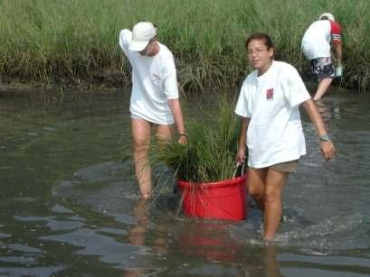
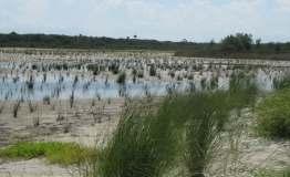
5 Carbon sequestered and organics maximized for fiddler crabs by burying plants
6
7 1-2 years
8 3-5 years
9 8 years

10 Dragline ditch
11 2yrs post-restoration
12 Pristine wetland


13 Mosquito Lagoon Natural Wetland Ecology residents Net production transients
14 12 Black Mangrove Density- February 2007 Mean No. Plants/m 2 (+SE) D-12N D-12S3 D-12S2 D-12S1 V-2 V-1 Control (D-12) Control (V) Youngest (1mth) Oldest (8yrs) Pristine wetlands 0 m 5 m 10 m 30 m Distance From Shore Saltwort Density- February 2007 Mean No. of Plants/m 2 (+SE) D-12N D-12S3 D-12S2 D-12S1 V-2 V-1 Control (D-12) Control (V) 0 m 5 m 10 m 30 m Distance from Shore Donnelly, 2009
15 21.3 acres of wetlands restored 45.9 acres of wetlands 24.6 acres of wetlands
16 $3650 per acre to restore Provides 50lbs of fish biomass per acre annually to adjacent waters Stevens et al (600 restored acres produce 15tons annually) Provides $13,400 per acre in coastal storm protection Costanza 2008 (600 restored acres provide $8,040,000 protection)
17
18 Harbor Branch Impoundment Reconnection
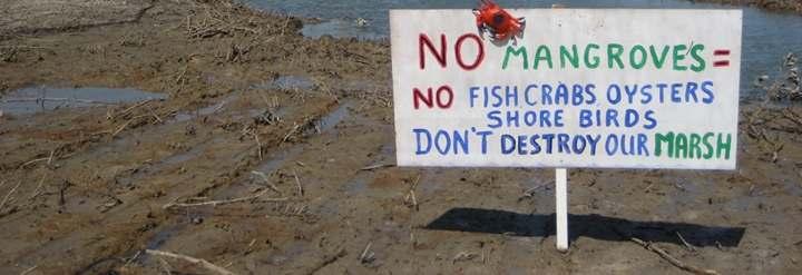
19 CURRENT CONDITIONS Degraded water quality Invasive/exotic Brazilian Pepper on 40 of 178 acres Mangroves in poor health due to impaired hydrology Marine organisms can not migrate from Lagoon to wetland for foraging/nursery Products of primary productivity not transported to Lagoon


20 PROJECT OBJECTIVES 1. Restore tidal connectivity to 178 acres of estuarine intertidal forested habitat that are currently impounded and re-establish historic mangrove marsh status. Stabilize the perimeter dike with geotextile tubes, fill, and native plantings. Install culverts and tide gates allowing natural tidal exchange. Broadcast red mangrove propagules throughout the wetlands after natural eradication has occurred 2. Provide educational, research, and recreational opportunities to high school and FAU/HBOI students. 3. Monitor the structural and functional success of the project.
21 PROJECT PARTNERS AND FUNDING $1.15M St. Lucie County Mosquito Control.$1,500,000 US Fish and Wildlife Service (USFWS)...1,000,000 Florida Fish and Wildlife Conservation Commission (FWC)....5,000 State of Florida.. 4,500,000 South Florida Water Management District (SFWMD).574,000 Florida Inland Navigation District(FIND)..480,000 FDEP/NOAA CZM program..150,000 Total...$8,209,000
22 Impoundment with an outer berm Impoundment outer berm removal
23 Former mariculture ponds, West Bay
24 Winter Beach, IRL
25 FWC Mosquito Lagoon Marine Enhancement Center FWC site property boundary with project area
26 Shoreline Stabilization Demo Area
27
28 Clam Bayou, Tampa Bay (1-year sequence)
29 Indian River Lagoon Spoil Island SL15

30 Before 6yrs after

31 Grassy Flats Lake Worth Lagoon Tidal Marsh Tidal Flat Mangrove Oyster Reef Seagrass


 Scheduled")
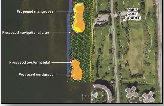
32 Grassy Flats Restoration Methods Place approx. 50,000 cu yards of sand over 12.8 acres of muck with sand shooter Place 5,000 tons of limestone to stabilize sediments Plant 2,900 red mangroves (volunteers) Plant 25,000 plugs of smooth cordgrass(volunteers) Scheduled to begin Fall 2013/Winter 2014
 1.")


33 Grassy Flats Benefits acres seagrass habitat (restored and enhanced) 1.74 acres of tidal marsh, tidal flat and mangroves 0.57 acre oyster reef Water quality improvements (muck capping, vegetation, oysters) Species to benefit include fish & birds and federally listed Johnson s seagrass & manatees Increased shoreline resilience to climate change
34 Fringing wetlands
Initial recovery of flora and fauna at restored mosquito impoundments in Indian River Lagoon, FL
 Initial recovery of flora and fauna at restored mosquito impoundments in Indian River Lagoon, FL Melinda Donnelly PhD Candidate, University of Central Florida Ron Brockmeyer, Linda Walters, William Greening,
Indian River Lagoon: Lessons, Challenges and Opportunities
 Indian River Lagoon: Lessons, Challenges and Opportunities Upper Chain of Lakes Lake Kissimmee Kissimmee River Indian River Lagoon Caloosahatchee Estuary Lake Okeechobee St. Lucie Estuary Mark Perry, Executive
WHAT ARE ECOSYSTEMS? Dr. V. N. Nayak Professor of Marine Biology (Retd)
") WHAT ARE ECOSYSTEMS? Dr. V. N. Nayak Professor of Marine Biology (Retd) An ECOSYSTEM is an interacting system of plant, animals, and humans and the surrounding environment. An ecosystem contains living
WHAT ARE ECOSYSTEMS? Dr. V. N. Nayak Professor of Marine Biology (Retd) An ECOSYSTEM is an interacting system of plant, animals, and humans and the surrounding environment. An ecosystem contains living
Puget Sound Nearshore Ecosystem Restoration Project Restore America s Estuaries Conference 2012 Tampa, FL
 Restore America s Estuaries Conference 2012 Tampa, FL presented by: Theresa Mitchell, WA Dept. of Fish & Wildlife Nearshore General Investigation Change Analysis: Comparison of historical and current
Project Webpage:
 Project Webpage: http://nature.ly/marinesatlanticbightera Coastal Data and Full Metadata: http://easterndivision.s3.amazonaws.com/marine/sab MA/SABMACoastalEcosystems.zip Coastal Chapter: http://easterndivision.s3.amazonaws.com/marine/sab
Cat Island Chain Restoration
 Cat Island Chain Restoration 1820s Fox River Military Road Map to Fort Howard 1845 Chart of Green Bay & Fox River Cat Island Chain - 1938 Cat Island Brown County Aerial Photography, 1938 Historic Western
National Oceanic and Atmospheric Administration (NOAA)/ Mulberry Phosphate Trustee Council September 12, 2013
/ Mulberry Phosphate Trustee Council September 12, 2013") OYSTER REEF CREATION PROJECT DESIGN AND IMPLEMENTATION IN HILLSBOROUGH BAY, FLORIDA TAMPA BAY REGIONAL PLANNING COUNCIL AGENCY ON BAY MANAGEMENT MEETING National Oceanic and Atmospheric Administration
OYSTER REEF CREATION PROJECT DESIGN AND IMPLEMENTATION IN HILLSBOROUGH BAY, FLORIDA TAMPA BAY REGIONAL PLANNING COUNCIL AGENCY ON BAY MANAGEMENT MEETING National Oceanic and Atmospheric Administration
Warm-up # 7 A day 5/17 - B day 5/18 UPDATE YOUR TABLE OF CONTENTS
 Warm-up # 7 A day 5/17 - B day 5/18 UPDATE YOUR TABLE OF CONTENTS Question: List all examples of surface water on Earth. Answer: Rivers and streams, lakes and reservoirs, (ponds) wetlands, estuaries and
Estuarine Shoreline Stabilization
 Estuarine Shoreline Stabilization Property Owner s Guide to Determining the Most Appropriate Stabilization Method Estuarine shorelines are dynamic features that experience continued erosion. Land is lost
FACT SHEET MCGREGOR LAKE RESTORATION HABITAT PROJECT POOL 10, UPPER MISSISSIPPI RIVER, WISCONSIN ENVIRONMENTAL MANAGEMENT PROGRAM
 FACT SHEET MCGREGOR LAKE RESTORATION HABITAT PROJECT POOL 10, UPPER MISSISSIPPI RIVER, WISCONSIN ENVIRONMENTAL MANAGEMENT PROGRAM LOCATION McGregor Lake is located within a mid-river island in Pool 10
The Blue Heron Slough Conservation Bank
 1 The Blue Heron Slough Conservation Bank CONSERVATION BANKING July 19-23, 2010 CASE STUDY SERIES The Blue Heron Slough Conservation Bank (Washington) I. OVERVIEW & BACKGROUND: Location: Snohomish River
Blakely Island, N Thatcher Bay. Restoration Recommendation: Rank Score (total score)
") Soft Shore Protection/Structure Removal Blueprint for San Juan County Forage Fish Beaches Appendix 2: Recommendations for sites scoring below the top ten, sorted by island (east to west) Blakely Island,
Soft Shore Protection/Structure Removal Blueprint for San Juan County Forage Fish Beaches Appendix 2: Recommendations for sites scoring below the top ten, sorted by island (east to west) Blakely Island,
Puget Sound Shorelines. Waves and coastal processes. Puget Sound shorelines: Effects of beach armoring
 Puget Sound Shorelines Puget Sound shorelines: Effects of beach armoring Waves and coastal processes Factors affecting wave energy hitting the coast Processes transporting sediment along coastlines What
Restoration of Intertidal Oyster Reefs Affected by Boating Activity in Mosquito Lagoon, Florida
 Restoration of Intertidal Oyster Reefs Affected by Boating Activity in Mosquito Lagoon, Florida Andrea Barber, University of Central Florida Dr. Linda Walters, University of Central Florida Anne Birch,
EVALUATING THE EFFECTS OF BIVALVE SHELLFISH AQUACULTURE AND ITS ECOLOGICAL ROLE IN THE ESTUARINE ENVIRONMENT IN THE UNITED STATES
 EVALUATING THE EFFECTS OF BIVALVE SHELLFISH AQUACULTURE AND ITS ECOLOGICAL ROLE IN THE ESTUARINE ENVIRONMENT IN THE UNITED STATES Brett Dumbauld USDA Agricultural Research Service, Hatfield Marine Science
AGENCY/ORGANIZATION OFFICE/DIVISION SECTION/SUBSECTION ACTIONS (Related to Coral Reefs) Natural Resources Planning and Management Division
 Natural Resources Planning and Management Division") AGENCY/ORGANIZATION OFFICE/DIVISION SECTION/SUBSECTION ACTIONS (Related to Coral Reefs) Broward County Environmental Protection and Growth Department Natural Resources Planning and Division Broward County
AGENCY/ORGANIZATION OFFICE/DIVISION SECTION/SUBSECTION ACTIONS (Related to Coral Reefs) Broward County Environmental Protection and Growth Department Natural Resources Planning and Division Broward County
Response of a Newly Created Marsh-Wetland Affected by Tidal Forcing, Upland Discharge, and Groundwater Interaction
 Response of a Newly Created Marsh-Wetland Affected by Tidal Forcing, Upland Discharge, and Groundwater Interaction Mouth of Columbia River, Cape Disappointment State Park, Washington 12 Hans R. Moritz
National Marine Fisheries Service, Habitat Conservation Division:
 National Marine Fisheries Service, Habitat Conservation Division: Essential Fish Habitat, South East Florida Coral Reef Initiative and Land- Based Sources of Pollution effects on Critical Fisheries Habitats
Coastal Hazards and Management in North Carolina. Braxton Davis April 14, 2015
 Coastal Hazards and Management in North Carolina Braxton Davis April 14, 2015 Coastal Facts and Figures 320 miles of ocean beaches 12,000+ miles of estuarine shoreline 2 million + acres of sounds, creeks,
Friends of the Detroit River Habitat Restoration Project Update
 Friends of the Detroit River Habitat Restoration Project Update 11 Beneficial Use Impairments (BUIs) were originally identified to be associated with the Detroit River: 1. Restrictions on fish and wildlife
Marine Ecosystems. Aquatic Ecosystems Section 2
 Marine Ecosystems Marine ecosystems are located mainly in coastal areas and in the open ocean. Organisms that live in coastal areas adapt to changes in water level and salinity. Organisms that live in
US Beach Nourishment Experience:
 Beach Nourishment: Introduction of new sand to the beach by truck or dredge Large beach >1 million cubic yards (100,000 dump truck loads) Funding is a combination of federal, state, local & private Also
Collaborative. City of Stuart. September 7, Mark Perry, Executive Director Oceanographic Society. Upper Chain of Lakes
 Lake Okeechobee Collaborative Upper Chain of Lakes Lake Kissimmee Indian River Lagoon City of Stuart September 7, 2016 Kissimmee River Caloosahatchee Estuary Lake Okeechobee St. Lucie Estuary Everglades
FACT SHEET I. LOCATION
 STEAMBOAT ISLAND HABITAT REHABILITATION AND ENHANCEMENT PROJECT (HREP) SCOTT COUNTY, IOWA, UPPER MISSISSIPPI RIVER RESTORATION-ENVIRONMENTAL MANAGEMENT PROGRAM ROCK ISLAND DISTRICT FACT SHEET I. LOCATION
Essential Fish Habitat: An overview of the consultation requirement for the American Association of Port Authorities
 Essential Fish Habitat: An overview of the consultation requirement for the American Association of Port Authorities National Marine Fisheries Service, Southeast Regional Office Habitat Conservation Division,
Examples of estuaries include bays, sounds, salt marshes, mangrove forests, mud flats, swamps, inlets, and sloughs.
 An estuary is a partially enclosed body of water where incoming seawater is mixed with fresh water coming from the land. Examples of estuaries include bays, sounds, salt marshes, mangrove forests, mud
Definitions. The environment is the biological, chemical, physical, and social conditions that surround organisms.
 Marine Ecosystems Definitions An ecosystem is a geographically specified system of organisms (including humans), the environment, and the processes that control its dynamics. The environment is the biological,
Three point plan to addressing land use and habitat loss impacts on Chesapeake Bay tidal fish and shellfish
 Three point plan to addressing land use and habitat loss impacts on Chesapeake Bay tidal fish and shellfish 1. Establish Principles for Protection of Chesapeake Bay Fish and Shellfish The Fisheries GIT
11426 Moorage Way P.O. Box 368 LaConner, WA Phone: Fax:
 Skagit River System Cooperative 11426 Moorage Way P.O. Box 368 LaConner, WA 98257-368 Phone: 36-466-7228 Fax: 36-466-447 www.skagitcoop.org BULL TROUT USE OF SWINOMISH RESERVATION WATERS Eric Beamer, Rich
East Central Florida Region Matt Culver, Brevard County James Gray, Indian River County Jim Oppenbourn, St. Lucie County Kathy Fitzpatrick, Martin
 James Gray, Indian River County January 14, 2015 East Central Florida Region Matt Culver, Brevard County James Gray, Indian River County Jim Oppenbourn, St. Lucie County Kathy Fitzpatrick, Martin County
Waikanae River Environmental Strategy. 12. Arapawaiti/Otaihanga Reach
 74 Waikanae River Environmental Strategy 12. Arapawaiti/Otaihanga Reach Figure 12: Arapawaiti/Otaihanga Reach 75 PART C: Protecting and Improving the River Corridor / Arapawaiti/Otaihanga Reach Waikanae
Mosquito Control Impoundments 1
 ENY648 1 Jorge R. Rey and C. Roxanne Connelly 2 Introduction A mosquito control impoundment is a salt marsh or mangrove forest with an earthen dike around the perimeter that allows the area to be artificially
Healthy, self-sustaining
 HABITAT HOTLINE Atlantic 2011 Annual Issue Spotlight on Habitat Restoration Projects: Oyster Reefs and Mosquito Ditches Oyster Reef Restoration Projects The Eastern oyster (Crassostrea virginica) once
Eastern Brook Trout. Roadmap to
 Eastern Brook Trout Roadmap to CONSERVATION Our Brook Trout heritage he wild Brook Trout is an American symbol of persistence, adaptability, and the pristine wilderness that covered North America prior
Building Coastal Resiliency at Plymouth Long Beach
 Building Coastal Resiliency at Plymouth Long Beach Department of Marine and Environmental Affairs March 30, 2017 Introducing Green Infrastructure for Coastal Resiliency Plymouth Long Beach & Warren s Cove
Habitat Fact Sheets. Rocky habitats are dominated by seaweeds and often mussels, which rely on the rocks for attachment.
 Habitat Fact Sheets Habitats in the Gulf of Maine serve many important roles for the environment and for humans as well. These include: cycling nutrients, filtering pollution, trapping sediments, storing
Overview Open Space and Recreation
 Overview Open Space and Recreation Open Space Plan (2004) Environmental Priority Areas Town Character Priority Areas Recreational Facilities maintained by the Town RSU 21 Recreational Facilities in Kennebunk
Kissimmee River Channelization
 Environmental Restoration ti Update Phil Flood, South Florida Water Management District Presentation Overview Kissimmee River Restoration Everglades Stormwater Treatment Areas Comprehensive Everglades
Case Study: Merritt Island National Wildlife Refuge
 Case Study: Merritt Island National Wildlife Refuge Read the case study below. As you read, complete the Case Study Notetaking worksheet. Geography Cape Canaveral is on the east coast of Florida, roughly
Survival in an Estuary. Life in a Transition Zone
 Estuary An estuary is a semi-enclosed coastal body of water which has a free connection with the open sea and within which sea water is measurably diluted with fresh water derived from land drainage. (D.
PLAQUEMINES PARISH BARRIER ISLAND RESTORATION & SUSTAINABILITY. MVD/Gulf Coast Regional Dredging Meeting November 5, 2013
 PLAQUEMINES PARISH BARRIER ISLAND RESTORATION & SUSTAINABILITY MVD/Gulf Coast Regional Dredging Meeting November 5, 2013 OVERVIEW 1. Barrier Island Restoration Projects in Plaquemines Parish 2. Plaquemines
SALINITY. It's the amount of dissolved salts the water contains.
 AQUATIC ECOSYSTEMS SALINITY The types of organisms in an aquatic ecosystem depend upon the water s Salinity. It's the amount of dissolved salts the water contains. Salinity determines the two main aquatic
Living Shorelines Non-structural Erosion Control Practices Rhode Island Land & Water Summit, 2014
 Living Shorelines Non-structural Erosion Control Practices Rhode Island Land & Water Summit, 2014 D. Steven Brown (1) Kevin Ruddock (1) Rhonda Smith (2) The Nature Conservancy United States Fish and Wildlife
CHAPTER 4 DESIRED OUTCOMES: VISION, GOALS, AND OBJECTIVES
 CHAPTER 4 DESIRED OUTCOMES: VISION, GOALS, AND OBJECTIVES Vision One of the first steps in developing this Plan was articulating a vision - a clear statement of what the Plan strives to achieve and what
VIMS CCRM Coastal Management Decision Tools. Decision Tree for Undefended Shorelines and Those with Failed Structures
 VIMS CCRM Coastal Management Decision Tools Decision Tree for Undefended Shorelines and Those with Failed Structures Center for Coastal Resources Management Virginia Institute of Marine Science Gloucester
Smith Ranch Okeechobee, Florida Saint Lucie & Okeechobee Counties
 Smith Ranch Okeechobee, Florida Saint Lucie & Okeechobee Counties 8,768 +/- Acres Cattle Operation and Exotic Game Preserve Smith Ranch Okeechobee, Florida Saint Lucie & Okeechobee Counties Cattle Operations
Significant Ecological Marine Area Assessment Sheet
 Significant Ecological arine Area Assessment Sheet Name: ouhora arbour arine Values Summary: The entrance subtidal channel, tidal flats, seagrass mangrove and saltmarsh habitats of ouhora arbour have given
Effectiveness of Beach Nourishment in Response to Sea Level Rise
 2014 FSBPA Annual Conference Effectiveness of Beach Nourishment in Response to Sea Level Rise Navarre Beach Santa Rosa County July 18, 2005 Lovers Key Lee County April 23, 2012 South County St. Lucie County
29 National Estuarine Research Reserves
 Estuarine habitat is where it's at! Living Shorelines for Erosion Control Whitney Jenkins North Carolina Coastal Reserve & National Estuarine Research Reserve Division of Coastal Management 29 National
Creation of Fish and Wildlife Habitat on the Closed Salmon Harbour Mine in Minto, NB
 Creation of Fish and Wildlife Habitat on the Closed Salmon Harbour Mine in Minto, NB M. Coleman 1, R. Rutherford 2, RA Currie 3 1 NB Power 2 Thaumas Environmental Consultants Ltd 3 RA Currie Ltd. Location
SHORE PROTECTION AND HABITAT CREATION AT SHAMROCK ISLAND, TEXAS ABSTRACT
 SHORE PROTECTION AND HABITAT CREATION AT SHAMROCK ISLAND, TEXAS M. Cameron Perry, P.E., and Daniel J. Heilman, P.E. Coastal Engineer Shiner Moseley & Associates., Inc. 555 N. Carancahua Corpus Christi,
Eric Sparks.
 Eric Sparks eric.sparks@msstate.edu AL.com AL.com NOAA Gulf Spill Restoration Ecological Consulting Services, Inc. Eric Sparks Shoreline begins to recede Bulkhead installed Vertical erosion occurs
RESILIENCE THROUGH RESTORATION
 RESILIENCE THROUGH RESTORATION RECLAMATION DISTRICT NO. 1601 TWITCHELL ISLAND SAN JOAQUIN RIVER SETBACK LEVEE PROJECT TWITCHELL ISLAND BASICS Nearly 12 miles of levee Storm drainage facilities Protects
San Diego Shorebird Survey Tijuana River Survey Areas
 San Diego Shorebird Survey Tijuana River Survey Areas Legend Survey Area North McCoy South McCoy Helicopter Airfield North River Mouth- Beach North River Mouth-Marsh South River Mouth- Marsh South River
For more information or permission to reprint slides, please contact Donna Milligan at 1
 For more information or permission to reprint slides, please contact Donna Milligan at milligan@vims.edu 1 For more information or permission to reprint slides, please contact Donna Milligan at milligan@vims.edu
What happens to Oregon s tidal wetlands with sea level rise?
 What happens to Oregon s tidal wetlands with sea level rise? Laura Brophy Estuary Technical Group Institute for Applied Ecology Corvallis, OR Laura@appliedeco.org Project maps future tidal wetlands, predicts
Subtidal and intertidal restored reefs in North Carolina
 Subtidal and intertidal restored reefs in North Carolina Jonathan H. Grabowski 1, Sean P. Powers 2, Pete Peterson 3, and Hunter S. Lenihan 4 1 Gulf of Maine Research Institute/U. Maine-Darling Marine Center
Eastern Brook Trout Joint Venture Completed Project Report Form
 Eastern Brook Trout Joint Venture Completed Project Report Form Project Title: Assessing the Efficacy of Remediating Episodic Low ph (and High Aluminum) Concentrations in Headwater Brook Trout Streams
Wood Storks & Wetlands. UCF Jan. 26, 2010 Jason Lauritsen Asst. Director Corkscrew Swamp Sanctuary
 Wood Storks & Wetlands UCF Jan. 26, 2010 Jason Lauritsen Asst. Director Corkscrew Swamp Sanctuary Stork Overview 1984 on Endangered Species List South Carolina, Georgia, Alabama & Florida Mature at 3-4
RESTORING THE CONNECTION BETWEEN CREEK AND LAKE: FRESH WATER ESTUARINE CREATION IN MISSISSAUGA
 RESTORING THE CONNECTION BETWEEN CREEK AND LAKE: FRESH WATER ESTUARINE CREATION IN MISSISSAUGA Jeff Doucette, Kenneth Dion and Sally-Beth Betts 6 th International Conference on Natural Channel Systems
FINAL HARRIS CHAIN OF LAKES RESTORATION COUNCIL SITE VISIT SUMMARY. of the. Projects Tour March 3, 2006
 FINAL HARRIS CHAIN OF LAKES RESTORATION COUNCIL SITE VISIT SUMMARY of the Projects Tour March 3, 2006 The regular meeting of the Harris Chain of Lakes Restoration Council (Council) was cancelled to facilitate
1. Distribute the activity sheet, and allow 20 minutes for the first use.
 A LOCAL WAY OF LEARNING Title: MISSING MANGROVE MESSAGE Author: Eulalie R. Rivera Elementary School Environmental Education Team Grade Level: 4-6 Concepts: 2.Ecosystem 6.Resources 9.Change Disciplines:
OYSTER REEF RESTORATION; RESTORING ECOLOGICAL FUNCTION
 OYSTER REEF RESTORATION; RESTORING ECOLOGICAL FUNCTION Paul Jensen, David Buzan, and Ka-Leung Lee; Atkins Mark Dumesnil and Julie Sullivan; The Nature Conservancy Presentation Overview The Nature Conservancy
Protecting our Beaches
 Protecting our Beaches South Amelia Island Shore Stabilization Project Nassau County, FL Mr. Drew Wallace President South Amelia Island Shore Stabilization Association (SAISSA) Mr. Bill Moore, AICP Project
Coastal management has lagged behind the growth in population leading to problems with pollution
 Fifty percent of the population of the industrialized world lives within 100 km of a coast. Coastal management has lagged behind the growth in population leading to problems with pollution and natural
Artificial Habitats For Marine And Freshwater Fisheries READ ONLINE
 Artificial Habitats For Marine And Freshwater Fisheries READ ONLINE If searching for a book Artificial Habitats for Marine and Freshwater Fisheries in pdf form, then you've come to the right site. We furnish
Overview. Beach Features. Coastal Regions. Other Beach Profile Features. CHAPTER 10 The Coast: Beaches and Shoreline Processes.
 Overview CHAPTER 10 The Coast: Beaches and Shoreline Processes Coastal regions constantly change. The beach is a dominant coastal feature. Wave activity continually modifies the beach and coastal areas.
Follets Island Nearshore Beach Nourishment Project
 Coast & Harbor Engineering A division of Hatch Mott MacDonald Follets Island Nearshore Beach Nourishment Project Arpit Agarwal, P.E. April 1, 2016 Project Site!"#$% &'(% &)*+% )#,'-+% Shoreline Erosion
Living Shorelines. Created by: JoAnn Moody & Tina Miller-Way Discovery Hall Programs Dauphin Island Sea Lab
 Living Shorelines Created by: JoAnn Moody & Tina Miller-Way Discovery Hall Programs Dauphin Island Sea Lab Living Shorelines Subject: Life Science Grade Level: 6 th -8 th Time Required: 60 min Key Terms:
Sea-Level Rise and Coastal Habitats in Southeastern Louisiana An Application of the SLAMM Model
 Sea-Level Rise and Coastal Habitats in Southeastern Louisiana An Application of the SLAMM Model Patty Glick (National Wildlife Federation) Jonathan Clough (Warren Pinnacle Consulting, Inc.) Amy Polaczyk
CONSERVATION AND MANAGEMENT OF COASTAL WETLANDS IN CALIFORNIA
 Studies in Avian Biology No. 2: 151-155, 1979. CONSERVATION AND MANAGEMENT OF COASTAL WETLANDS IN CALIFORNIA JOHN SPETH' The title, Conservation and Management of Coastal Wetlands in California, implies
Dr. Prakash N. Mesta
 Coastal Wetland Monitoring Dr. Prakash N. Mesta prakashhonavar@gmail.com Coastal Ecosystem is diverse in nature Most of the world human population p settled in Coastal region. Cities & Industries established
Final Waterways Assets and Resources Survey Master Plan for Dredging and Beach Nourishment
 Final Waterways Assets and Resources Survey Master Plan for Dredging and Beach Nourishment For, Massachusetts Prepared For: Dennis Town Hall P.O. Box 2060 485 Main Street Dennis, MA 02660 Prepared By:
Let s take a closer look at estuaries and learn why they are important.
 ave you ever wondered what happens where a river or stream flows into the ocean? When fresh water meets saltwater in a protected bay or inlet, a partially enclosed body of water called an estuary often
Good Mooring to You! Jensen Beach Mooring Field. Kathy Fitzpatrick, P.E. Coastal Engineer, Martin County
 Good Mooring to You! Kathy Fitzpatrick, P.E. Coastal Engineer, Martin County Penny Cutt Regional Manager, Coastal Systems International Mooring Field Advantages Provide a safe and secure anchorage at a
LOCAL COASTAL PROGRAM UPDATE
 LOCAL COASTAL PROGRAM UPDATE Agenda Meeting #1 General Information (1 1:45 pm) Introductions and Background Grants involved What is a Local Coastal Program? What is required? LCP Update tasks and schedule
Maryland Chapter Trout Unlimited Brook Trout Conservation Effort
 Maryland Chapter Trout Unlimited Brook Trout Conservation Effort Photo by Matt Kline Portfolio of Recent Work MDTU Brook Trout Conservation Coordinator: Scott C. Scarfone, ASLA sscarfone@oasisdesigngroup.com
Klickitat County Shoreline Master Program Update. Open House March 15, 2017
 Klickitat County Shoreline Master Program Update Open House March 15, 2017 Agenda 6:00 6:10 Welcome 6:10 6:40 Presentation SMP Update Process Shoreline Analysis review 6:40 8:00 Open House Topics SMP Process
NOTICE OF DECISION. DATE: June 13, 2017
 NOTICE OF DECISION DATE: June 13, 2017 TO: FROM: SUBJECT: All Respondents to RFP2017-005 National Estuary Program: 2017-2018 Request for Proposals Category 3: Science and Innovative Projects Frank Sakuma,
Managing floodplain productivity: Slow it down, Spread it out, Grow em Up
 Managing floodplain productivity: Slow it down, Spread it out, Grow em Up Jacob Katz California Trout C. Jeffres Inland Sea J street Flood of 1862 A Shifting Mosaic of Wetland Habitat Types Dynamic Permanence
Context Most US West Coast open coast estuaries have: INTERTIDAL AQUACULTURE AS HABITAT IN PACIFIC NORTHWEST COASTAL ESTUARIES: CONSIDERING SCALE
 INTERTIDAL AQUACULTURE AS HABITAT IN PACIFIC NORTHWEST COASTAL ESTUARIES: CONSIDERING SCALE Brett Dumbauld USDA Agricultural Research Service Context Most US West Coast open coast estuaries have: Broad
Energy Attenuation & Hybrid Living Shorelines: A Viable Tool for Coastal Resilience
 Energy & Hybrid Living Shorelines: A Viable Tool for Coastal Resilience Hot Topic Session Delaware Estuary Science & Environmental Summit Balancing Progress & Protection 10 Years of Science in Action January
Restoring the Iconicc Lower Cache River
 Restoring the Iconicc Lower Cache River A new chapter holds promise of revitalizing cherished waters and woods The story of conservation in the lower Cache River and surrounding Big Woods of eastern Arkansas
ALTERNATIVES FOR COASTAL STORM DAMAGE MITIGATION
 ALTERNATIVES FOR COASTAL STORM DAMAGE MITIGATION Dave Basco Old Dominion University, Norfolk, Virginia, USA National Park Service Photo STRUCTURAL (changes to natural, physical system) hardening (seawalls,
DELAWARE S VULNERABLE COASTAL AREAS. DELAWARE INLAND BAYS and DELAWARE BAY RECONNAISSANCE STUDY
 DELAWARE S VULNERABLE COASTAL AREAS and the DELAWARE INLAND BAYS and DELAWARE BAY RECONNAISSANCE STUDY Kimberly K. McKenna, PG Delaware Dept. of Natural Resources & Environmental Control Division of Watershed
Marine Environments. Copyright 2011 LessonSnips
 Marine Environments I must go down to the seas again, for the call of the running tide Is a wild call and a clear call that may not be denied Excerpt from a poem by John Masefield Continents and islands
CHAPTER 11.1 THE WORLD OCEAN MARINE BIOMES NOTES
 CHAPTER 11.1 THE WORLD OCEAN MARINE BIOMES NOTES 1. The world ocean can be divided into zones both and. The,, and zones that apply to large lakes also apply to the ocean. 2. In addition to the depth zones,
Atlantic Coast of Long Island, Jones Inlet to East Rockaway Inlet, Long Beach Island, NY Construction Update
 Atlantic Coast of Long Island, Jones Inlet to East Rockaway Inlet, Long Beach Island, NY Construction Update June 2016 US Army Corps of Engineers Project Purpose Three specific damage mechanisms of coastal
Conserving the Forests, Lakes and Streams of Northeast Michigan
 4241 Old US 27 South, Suite 2, Gaylord, Michigan 49735 (989) 448-2293 www.huronpines.org info@huronpines.org Prioritized Restoration Projects in the AuSable River Watershed Summer 2015 Update from Huron
The Sand Beaches of New Hampshire and Maine
 The Sand Beaches of New Hampshire and Maine Beach Preservation and Erosion Control Photographs provided by Joe Kelly and Steve Adams Cover photo: Reid State Park, ME Introduction The sand beaches of New
Shoreline Studies Program, Department of Physical Sciences, VIMS
 Living Shoreline Training Class 2017 1 Demonstration sites discussed in this talk. 2 A shoreline management plan for the entire creek made conceptual shoreline management recommendations along every stretch
Mouth of the Columbia River Jetties Three-Phase Construction Plan
 Mouth of the Columbia River Jetties Three-Phase Construction Plan Project Overview October 9, 2012 US Army Corps of Engineers MCR Jetties Major Rehabilitation Sand Island pile dikes 1930-1935 Columbia
Great Bay National Estuarine Research Reserve Field Notes Summer 2010 Welcome
 Great Bay National Estuarine Research Reserve Field Notes Summer 2010 Welcome Welcome to the spring edition of Field Notes, a newsletter just for our Great Bay Community Land Stewards. Spring certainly
COLUMBIA LAKE DAM REMOVAL PROJECT
 COLUMBIA LAKE DAM REMOVAL PROJECT Major Goals of the Columbia Lake Dam Removal: Reconnect 10 miles of the Paulins Kill River to the Delaware River, restoring natural flow regime and sediment transport.
ALTERNATIVES FOR COASTAL STORM DAMAGE MITIGATION AND FUNCTIONAL DESIGN OF COASTAL STRUCTURES
 The University of the West Indies Organization of American States PROFESSIONAL DEVELOPMENT PROGRAMME: COASTAL INFRASTRUCTURE DESIGN, CONSTRUCTION AND MAINTENANCE A COURSE IN COASTAL DEFENSE SYSTEMS I CHAPTER
SOCIETAL GOALS TO DETERMINE ECOSYSTEM HEALTH: A FISHERIES CASE STUDY IN GALVESTON BAY SYSTEM, TEXAS
 SOCIETAL GOALS TO DETERMINE ECOSYSTEM HEALTH: A FISHERIES CASE STUDY IN GALVESTON BAY SYSTEM, TEXAS Anthony S. Pait, NOAA, National Centers for Coastal Ocean Science Thomas P. O Connor, David R. Whitall,
Completing the Puzzle: Conserving the Florida Keys Ecosystem One Parcel At a Time
 2007 Public Land Acquisition & Management Partnership Conference Completing the Puzzle: Conserving the Florida Keys Ecosystem One Parcel At a Time Anne Morkill Florida Keys National Wildlife Refuges Complex
KEYNOTE PRESENTATION FSBPA olsen
 AMELIA ISAND, FLORIDA BEACH MANAGEMENT PARTNERING AND PERSERVERENCE Erik Olsen, PE associates, inc. KEYNOTE PRESENTATION FSBPA 2009 IN ORDER TO ADDRESS SHORE PROTECTION TODAY LOCAL INTERESTS PARTNER WITH:
Clearlake Road (State Road 501) Project Development & Environment (PD&E) Study
 Project Development & Environment (PD&E) Study") Clearlake Road (State Road 501) Project Development & Environment (PD&E) Study FROM MICHIGAN AVENUE TO INDUSTRY ROAD BREVARD COUNTY, FLORIDA Financial Project ID No: 433605-1-22-01 Federal Aid Project
Clearlake Road (State Road 501) Project Development & Environment (PD&E) Study FROM MICHIGAN AVENUE TO INDUSTRY ROAD BREVARD COUNTY, FLORIDA Financial Project ID No: 433605-1-22-01 Federal Aid Project
Sediment Management Plan Rehoboth Bay
 Sediment Management Plan Rehoboth Bay STAC Meeting November 16, 2007 Goals of the Study Improve planning for future dredging needs Reduce the dependency on dredging Study Tasks Environmental data Historical