Flowering Rush An Invasive Aquatic Macrophyte Infesting the Columbia River Basin
|
|
|
- Oscar Ethan Adams
- 5 years ago
- Views:
Transcription


1 Flowering Rush An Invasive Aquatic Macrophyte Infesting the Columbia River Basin Virgil Dupuis Salish Kootenai College Peter Rice University of Montana

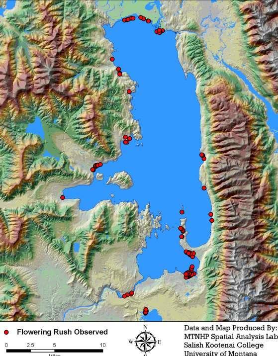
2 Pacific Northwest Distribution Montana Distribution Flathead Lake: 1964 Listed as noxious in Montana, Idaho, Washington, and Oregon Clark Fork River Noxon Reservoir Lake Pend O reille Yakima River Snake River Silver Lake Washington
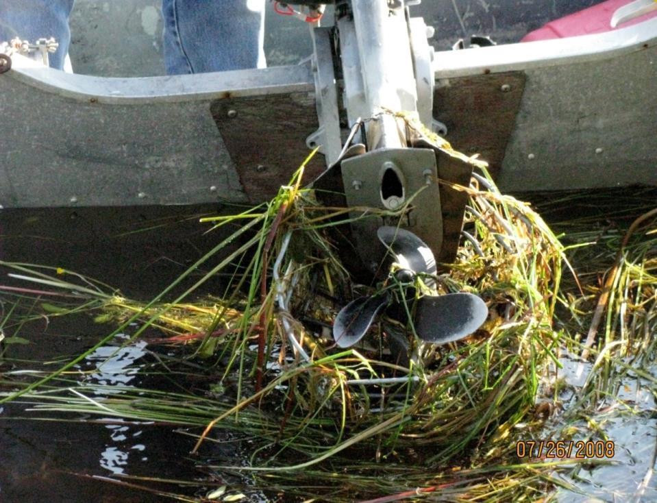
3 Environmental Impacts Form dense monocultures, excludes native aquatics Interferes with open water recreation Overtakes riparian backwater areas Clogs marinas, boat launches Habitat for swimmers itch host Interferes with irrigation water deliveries Provides habitat for invasive pike, perch, and bass, and has food web implications for lake trout, bull trout, and cutthroat Sedimentation, water temperatures, nutrient cycling

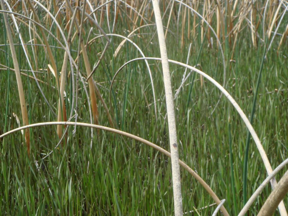
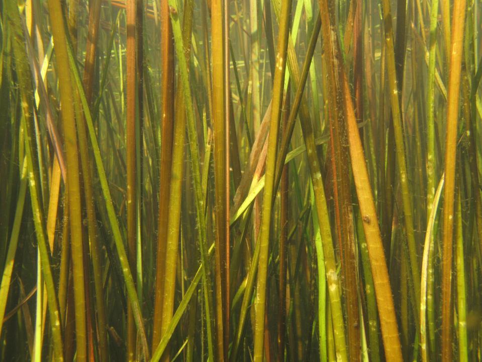
4 Fully Submerged Form Emergent Form Shoreline Form Literature: Rush found to 13 ft, In Flathead Lake found to 18 ft Flathead Lake 10 foot littoral zone

5
6 Initial Spatial Modeling Predictions Marcus Reddish 0-10 Littoral Littoral Size Acres Infested Acres Max Acres % of Lake 5,823 > , % 8,375 > , % 14,558 > 2,000 10, %
7


8 Invasive of Wetlands & Shoreline (Displacing Native Plants) and Sedimentation
9
10

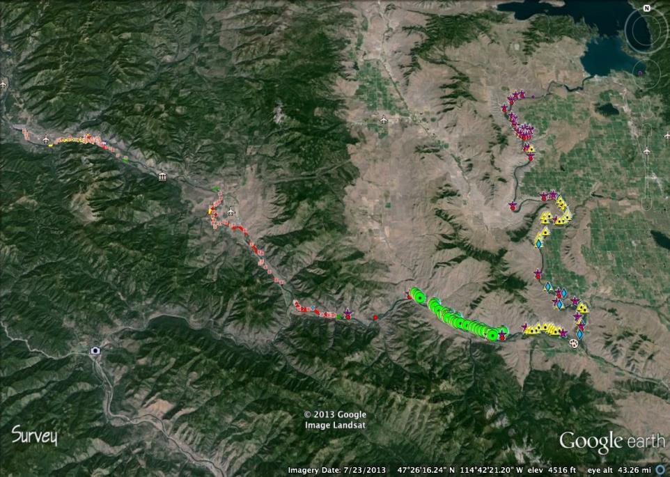
11 Flathead Valley Pablo Reservoir Irrigation Canal
 Great Pond Snail (Lymnaea")
12 Swimmer s Itch (schistosome cercarial dermatitis) Trematode Parasite (Trichobilharzia ocellata) Great Pond Snail (Lymnaea stagnalis)

13 Ducharme Fishing Access Flathead Lake
14 Vegetated vs. Open Water Littoral Zone
15


16 Native Salmonids Are Open Water Species These Introduced Piscivorous Fish Are Adapted to Vegetated Habitats (Dibble et al 1997)


17 Northern Pike Predation of Salmonids McMahon & Bennett 1996


18 Gregory & Powels Lake Trout Expand as Perch Prey Base Habitat Increases Magnifying Incidental Predation on Native Salmonids? Native Bull Trout Native Cutthroat Introduced Lake Trout Introduced Yellow Perch Yellow Perch Eggs on Vegetation


19 Montana Fish, Wildlife & Parks Radio Tag Study of Northern Pike Distribution in the Upper Flathead River

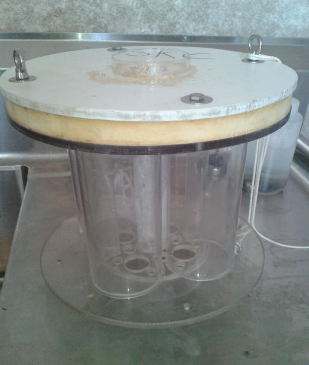
20 (Fennon Slough) Northern Pike Utilization of Flowering Rush


21 Northern Pike Bioenergetics Study (Upper Flathead River) Prey items Season WCT* BULL** Winter Spring 2,015 2,922 Summer 9,428 0 Fall 1, Totals 13,379 3,457 Bull Trout** & Cutthroats* Are Being Significantly Depredated by Northern Pike Muhlfeld et al. (2008)


22 Flowering Rush Fennon Slough Dominates Sloughs Being Used by Northern Pike Mill Creek Slough


23 Northern Pike Obligate Vegetation Spawners Eggs Attached Sac Fry Attached Fingerling Rearing

24 Flowering Rush in April (Fennon Slough, Upper Flathead River
25

26 A Sampling Methods Pilot Study: Flowering Rush Habitat Facilitation of Northern Pike & Macroinvertebrate Community Changes Peter Rice University of Montana Virgil Dupuis, Salish Kootenai College Eric Dibble, Mississippi State University
27


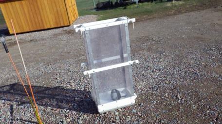

28 Trials for Sampling Methods
29 % Positive Samples Fennon Slough 2013Light Traps # light traps Largemouth Bass Yellow Perch Pumpkinseed Northern Pike 100% BUTUMB % Native Open Water
30 Aquatic Community NMS Relationship for 2012 Dip Net Samples Flowering Rush 100% Native Veg 100% Open Water Native Veg 25-90%

31 Low Pool Foliar/Exposed Sediments Herbicide Treatments Boom Buster 125, height 42 in, 40 PSI, 35 GPA TV, effective swath 15.5 ft 5 to 7 Inch Average Leaf Length East Bay May 27, 2008


32 CONTROL 140 DAT WITH IMAZAPYR


33 Need for A System-Wide / Multi-Partner Comprehensive Scientific Assessment Complete Main Stem Survey Water Level Management & Invasion Success Reproductive Phenology & Rhizome/Seed Dispersal Determine Genotypes Higher Trophic Level Impacts, affects on native fish Sediment Deposition & Transport Control Methods Professional Awareness Strategic Plan for Columbia River Basin


34 Summary Points Flowering Rush Colonizes Previously Unvegetated Littoral Zone Creating Northern Pike, Bass, and Perch Habitat Juvenile and adult Northern Pike Are Associated With Flowering Rush Infestations Northern Pike are Significantly Depredating Native Cutthrout & Bull Trout Populations Fish & Macroinvertebrate Community Composition is Being Altered from The Indigenous Native State Flowering rush is spreading down the Columbia
35 Funders and Supporters USDA-National Institute of Food and Agriculture Montana Department of Agriculture Montana Department of Fish, Wildlife and Parks Montana Legislature Confederated Salish and Kootenai Tribes
Flowering Rush An Invasive Aquatic Macrophyte Infesting the Columbia River Basin
 Flowering Rush An Invasive Aquatic Macrophyte Infesting the Columbia River Basin Peter Rice, University of Montana, Virgil Dupuis, Salish Kootenai i College Flowering Rush (Butomus umbellatus) umbel shaped
3 whitish pink petals & 3 similar sepals green leaves are triangular in cross section. leaf tips may be spirally twisted
 Flowering Rush An Invasive Aquatic Macrophyte Infesting the Columbia River Basin Peter Rice, University of Montana, Virgil Dupuis & Alvin Mitchell, Salish Kootenai College Flowering Rush (Butomus umbellatus)
Current Status and Management Recommendations for the Fishery in the Cloverleaf Chain of Lakes
 Current Status and Management Recommendations for the Fishery in the Cloverleaf Chain of Lakes Jason Breeggemann Senior Fisheries Biologist Wisconsin Department of Natural Resources Outline DNR fisheries
Current projects for Fisheries Research Unit of Minnesota Department of Natural Resources
 Current projects for Fisheries Research Unit of Minnesota Department of Natural Resources MAJOR RESOURCE ISSUES IN THE DIVISION OF FISHERIES Status of Fish Populations To effectively manage fish populations,
October 2, SUBJECT: Understanding the distribution and sources of invasive northern pike in the Columbia River basin
 James Yost Chair Idaho W. Bill Booth Idaho Guy Norman Washington Tom Karier Washington Jennifer Anders Vice Chair Montana Tim Baker Montana Ted Ferrioli Oregon Richard Devlin Oregon October 2, 2018 MEMORANDUM
Burns Paiute Tribe Fisheries Department. Evaluate The Life History Of Native Salmonids Within The Malheur Subbasin Project #
 Burns Paiute Tribe Fisheries Department Evaluate The Life History Of Native Salmonids Within The Malheur Subbasin Project # 199701900 Prior to 1990 Technical and/or scientific background Malheur population,
Don Pedro Project Relicensing
 Don Pedro Project Relicensing M ODESTO I RRIGATION D ISTRICT TURLOCK I RRIGATION D ISTRICT FERC PROJECT N O. 2299 Resident Fish in Don Pedro Reservoir Don Pedro Reservoir Fish Stocking (1971-Present) CDFG
Restoring the Kootenai: A Tribal Approach to Restoration of a Large River in Idaho
 Restoring the Kootenai: A Tribal Approach to Restoration of a Large River in Idaho Susan Ireland, Kootenai Tribe of Idaho Future of our Salmon Conference Technical Session August 2016 Healthy Floodplains,
July 24, Kalispel Tribe of Indians Update on Efforts to Suppress Northern Pike and Policy Implications
 Joan M. Dukes Chair Oregon Bruce A. Measure Montana James A. Yost Idaho W. Bill Booth Idaho Rhonda Whiting Vice-Chair Montana Bill Bradbury Oregon Tom Karier Washington Phil Rockefeller Washington July
NEVADA DEPARTMENT OF WILDLIFE STATEWIDE FISHERIES MANAGEMENT
 NEVADA DEPARTMENT OF WILDLIFE STATEWIDE FISHERIES MANAGEMENT FEDERAL AID JOB PROGRESS REPORTS F-2-52 216 CHIMNEY RESERVOIR WESTERN REGION NEVADA DEPARTMENT OF WILDLIFE, FISHERIES DIVISION JOB PROGRESS
Kootenai River Habitat Restoration Program. Kootenai Tribe of Idaho - January 27, 2014 Presentation for Kootenai Valley Resource Initiative
 Kootenai River Habitat Restoration Program Kootenai Tribe of Idaho - January 27, 2014 Presentation for Kootenai Valley Resource Initiative Decline of native species Kootenai River White Sturgeon ENDANGERED
LAKE DIANE Hillsdale County (T8-9S, R3W, Sections 34, 3, 4) Surveyed May Jeffrey J. Braunscheidel
 Surveyed May Jeffrey J. Braunscheidel") Michigan Department of Natural Resources Status of the Fishery Resource Report No. 2003-4, 2003 LAKE DIANE Hillsdale County (T8-9S, R3W, Sections 34, 3, 4) Surveyed May 2001 Jeffrey J. Braunscheidel Environment
Michigan Department of Natural Resources Status of the Fishery Resource Report No. 2003-4, 2003 LAKE DIANE Hillsdale County (T8-9S, R3W, Sections 34, 3, 4) Surveyed May 2001 Jeffrey J. Braunscheidel Environment
Crawford Reservoir. FISH SURVEY AND MANAGEMENT INFORMATION Eric Gardunio, Fish Biologist Montrose Service Center
 FISH SURVEY AND MANAGEMENT INFORMATION General Information: Crawford Reservoir is a popular fishery that provides angling opportunity for yellow perch, channel catfish, northern pike, rainbow trout, black
SKIATOOK LAKE MANAGEMENT PLAN
 SKIATOOK LAKE MANAGEMENT PLAN Background Skiatook Lake impounds Hominy Creek, 5 miles west of Skiatook in Osage County, Oklahoma (Figure 1). Skiatook Lake covers 10,540 surface acres and was constructed
Past, Present, and Future Fishery Management in Cabinet Gorge and Noxon Rapids Reservoirs
 Past, Present, and Future Fishery Management in Cabinet Gorge and Noxon Rapids Reservoirs Abstract Scott S. Rumsey and Joe E. Huston Montana Department of Fish, Wildlife and Parks Kalispell. MT 59901 Noxon
Introduction: JadEco, LLC PO BOX 445 Shannon, IL 61078
 Introduction: was contacted to collected data on the fishery for Lake Holiday. AC Electroshocking was conducted at 2 locations on September 28, 2015. Fish population data was collected for a total of 100
FWCP External Projects Delivered by Stakeholders and First Nations
 FWCP External Projects Delivered by Stakeholders and First Nations 2013-2014 For more information contact FWCP-Columbia program manager, Trevor Oussoren Trevor.oussoren@bchydro.com 250-365-4551 2013-2014
PRE- PROPOSAL FORM - Lewis River Aquatic Fund
 PRE- PROPOSAL FORM - Lewis River Aquatic Fund 1. Applicant organization. USDA Forest Service Gifford Pinchot National Forest 2. Organization purpose Resource management agency 3. Project manager (name,
2012 Bring Back the Natives Awarded Projects
 2012 Bring Back the Natives Awarded Projects EZG # Organization Project Title Project Description Location Description Total Award Amount Grantee Non- Federal Match 31904 Sanctuary Forest, Inc. Mattole
OKANAGAN RIVER RESTORATION INITIATIVE - FAQ
 OKANAGAN RIVER RESTORATION INITIATIVE - FAQ Initiative background: The health of the q awsitk w (Okanagan River) has been severely impacted by the channelization works that occurred in the mid-1950 s.
Below the Surface: Aquatic Invasives
 Below the Surface: Aquatic Invasives DATE AND TIME SPEAKER(S) Thursday, 25 February 2010 / 10AM-1130AM Doug Keller Aquatic Invasive Species Coordinator Indiana DNR, Division of Fish and Wildlife 402 W.
Mountain Columbia Province
 Rolling Provincial Review: Implementation 2001-2003 Province 229 Columbia Basin Fish & Wildlife Authority Province FY 2001-2003 Spending Summaries NPCC Recommendations and BPA Spending by Project Category,
Starry Stonewort (Nitellopsis obtusa) Removal Using Diver Assisted Suction Harvesting
 Removal Using Diver Assisted Suction Harvesting") Starry Stonewort (Nitellopsis obtusa) Removal Using Diver Assisted Suction Harvesting Silver Lake, Washington County, WI Brad Steckart, Aquatic Invasive Species Coordinator for Washington and Waukesha
Starry Stonewort (Nitellopsis obtusa) Removal Using Diver Assisted Suction Harvesting Silver Lake, Washington County, WI Brad Steckart, Aquatic Invasive Species Coordinator for Washington and Waukesha
2011 Haha Lake Northern Pike Control
 2011 Haha Lake Northern Pike Control Prepared By: Christin Davis Ministry of Forests, Lands, and Natural Resource Operations #401-333 Victoria Street Nelson, BC V1L 4K3 Summary In 2005, northern pike (Esox
strategy (#5) stated the intention to suppress nonnative fish through recreational angling. Assumptions included in the strategy were:
 stated the intention to suppress nonnative fish through recreational angling. Assumptions included in the strategy were:") Les Evarts Fisheries Program Manager Confederated Salish and Kootenai Tribes Natural Resources Department P.O. Box 278, Pablo, Montana 59855 Dear Les, The Flathead Valley Chapter of Trout Unlimited, representing
Les Evarts Fisheries Program Manager Confederated Salish and Kootenai Tribes Natural Resources Department P.O. Box 278, Pablo, Montana 59855 Dear Les, The Flathead Valley Chapter of Trout Unlimited, representing
Osoyoos Lake Aquatic Plant Mapping
 Osoyoos Lake Aquatic Plant Mapping AquaTechnex, LLC Presented to Okanogan County NWCB by PO Box 30824 Bellingham WA, 98228 www.aquatechnex.com Introductions Myriophyllum spicatum or Eurasian Milfoil has
Fisheries Management Plan Idaho Department of Fish and Game
 Fisheries Management Plan 2007-2012 2012 Idaho Department of Fish and Game Plan History 1981-1985 1985 Plan Separate anadromous plan Evolved from 5 to 6-year 6 plan Angler Opinion Survey The Process Public-Agency
Aquatic Plant Management and Importance to Sport Fisheries
 Aquatic Plant Management and Importance to Sport Fisheries Presentation to Michigan Inland Lakes Convention May 2014 Mike Maceina Professor Emeritus School of Fisheries, Aquaculture, and Aquatic Sciences
WFC 50 California s Wild Vertebrates Jan. 11, Inland Waters (Lakes and Streams) Lisa Thompson
 Lisa Thompson") Inland Waters: Lakes and Streams WFC 50 11 January 2011 Lisa Thompson Fisheries Extension Specialist Wildlife, Fish, & Conservation Biology Department University of California, Davis Take home messages
Inland Waters: Lakes and Streams WFC 50 11 January 2011 Lisa Thompson Fisheries Extension Specialist Wildlife, Fish, & Conservation Biology Department University of California, Davis Take home messages
Fish Community. Fish Habitat, Streams and Rivers
 Clear, Ston(e)y and White Lake Plan Fish Community The lakes support a cool/warm water fishery including muskellunge, walleye, largemouth and smallmouth bass, yellow perch, pumpkinseed, rockbass, blue
Yakima Klickitat Fisheries Project
 Yakima Klickitat Fisheries Project Michael Porter Fisheries Biologist Avian and Fish Predation studies Yakima River Basin Identification of Smolt Survival within the Yakima River Survival may be linked
P.O. Box 65 Hancock, Michigan USA fax
 This PDF file is a digital version of a chapter in the 2005 GWS Conference Proceedings. Please cite as follows: Harmon, David, ed. 2006. People, Places, and Parks: Proceedings of the 2005 George Wright
2010 Fishing Opener Prognosis. Central Region
 2010 Fishing Opener Prognosis Central Region Hinckley PINE COUNTY Pokegama, Cross, Island, Oak and North and South Big Pine Lakes are typically the best lakes for targeting walleye in Pine County. They
Fish Community and Aquatic Ecosystem Responses to the Cessation of Eurasian Watermilfoil Chemical Treatment on Lake Ellwood, Wisconsin
 Fish Community and Aquatic Ecosystem Responses to the Cessation of Eurasian Watermilfoil Chemical Treatment on Lake Ellwood, Wisconsin Greg G. Sass Wisconsin Department of Natural Resources Fisheries and
Mark A. Tonello and Ralph L. Hay
 Michigan Department of Natural Resources Status of the Fishery Resource Report No. 2003-3, 2003 Fife Lake Grand Traverse County (T25N, R09W, Section 13) Surveyed June 4-8, 2001 Mark A. Tonello and Ralph
Busse Reservoir South Lateral Pool Population Survey
 Busse Reservoir South Lateral Pool Survey Located in Elk Grove Village south of Higgins Rd. between RT 53/I-290 and Arlington Heights Rd. Busse Reservoir is comprised of three pools making up a total of
Quemahoning Reservoir
 Pennsylvania Fish & Boat Commission Biologist Report Quemahoning Reservoir Somerset County May 2011 Trap Net, Gill Net and Electrofishing Survey Quemahoning Reservoir is an 899 acre impoundment located
JadEco, LLC PO BOX 445 Shannon, IL 61078
 Introduction: With the assistance of Lake Holiday staff and volunteers, we were able to conduct an AC electrofishing survey on May 8, 27. Water temperatures were 2.3 C (8.5 F) and water clarity was decent
Goldfish Removal Millar s Pond. Resort Municipality of Whistler
 Goldfish Removal Millar s Pond Resort Municipality of Whistler Site Specific Removal of goldfish will differ per site Millar s Pond Amphibians present Pond is isolated from other waterbodies presence of
Pennsylvania Fish & Boat Commission Biologist Report. Wilmore Dam. Cambria County. May 2011 Trap Net, Electrofishing and Hoop Net Survey
 Pennsylvania Fish & Boat Commission Biologist Report Wilmore Dam Cambria County May 2011 Trap Net, Electrofishing and Hoop Net Survey Wilmore Dam is a 195 acre impoundment located in central Cambria County
MIDDLE FORK RESERVOIR Wayne County 2004 Fish Management Report. Christopher C. Long Assistant Fisheries Biologist
 MIDDLE FORK RESERVOIR Wayne County 2004 Fish Management Report Christopher C. Long Assistant Fisheries Biologist FISHERIES SECTION INDIANA DEPARTMENT OF NATURAL RESOURCES DIVISION OF FISH AND WILDLIFE
CARL BLACKWELL LAKE MANAGEMENT PLAN
 CARL BLACKWELL LAKE MANAGEMENT PLAN Background Lake Carl Blackwell impounds Stillwater Creek, 10 miles west of Stillwater in Payne County, Oklahoma (Figure 1). The lake covers 3,370 surface acres and was
PlaceNames Journal Lesson 1
 PlaceNames Journal Lesson 1 Title: Establishing a Sense of Place 1. What seasonal changes do you look for as signs of spring? Summer? Fall? Winter? 2. Do you have a favorite place, outdoors, where you
MARTINDALE POND Wayne County 2004 Fish Management Report. Christopher C. Long Assistant Fisheries Biologist
 MARTINDALE POND Wayne County 2004 Fish Management Report Christopher C. Long Assistant Fisheries Biologist Fisheries Section Indiana Department of Natural Resources Division of Fish and Wildlife I.G.C.
Winter Drawdown Issues of Concern
 Winter Drawdown Issues of Concern Wetland Connectivity Amphibians Fisheries Winter Drawdown Wetland Connectivity Wetland complex near Osprey Creek is not responsive to lake level Wetland at upper end of
MEMORANDUM Comfort Lake-Forest Lake Watershed District
 MEMORANDUM Comfort Lake-Forest Lake Watershed District To: Board of Managers Date: December 7, 2016 From: Mike Kinney Subject: 2016 Watercraft Inspections and AIS Report Summaries Watercraft Inspection
Exploring the relationship between native smallmouth bass and invasive mussels in the Huron Erie Corridor
 Exploring the relationship between native smallmouth bass and invasive mussels in the Huron Erie Corridor Nick Popoff Michigan Department of Natural Resources What is a Fishery? Fish Peop le Habitat Fishery
2014 Island Lake Survey June 13 th, 2014 Andrew Plauck District Fisheries Biologist Report Prepared 4 March 2015
 2014 Island Lake Survey June 13 th, 2014 Andrew Plauck District Fisheries Biologist Report Prepared 4 March 2015 BACKGROUND - A fish survey was requested due to a moderately severe winterkill in Island
Pickwick Lake 2018 REEL FACTS Trevor Knight Fisheries Biologist (662)
") Pickwick Lake 218 REEL FACTS Trevor Knight Fisheries Biologist trevork@mdwfp.state.ms.us (662) 84-5176 General Information: Covering 43,1 acres, Pickwick Lake, which borders Alabama, Tennessee, and Mississippi,
Pickwick Lake 218 REEL FACTS Trevor Knight Fisheries Biologist trevork@mdwfp.state.ms.us (662) 84-5176 General Information: Covering 43,1 acres, Pickwick Lake, which borders Alabama, Tennessee, and Mississippi,
Columbia Lake Dam Removal Project
 Columbia Lake Dam Removal Project The Columbia Lake dam located 1/4 mile upstream of the Paulins Kill River's confluence with the Delaware River in Knowlton Township, Warren County has been proposed for
Aquatic Invasive Species. September 30 th, 2014, NOFNEC
 Aquatic Invasive Species September 30 th, 2014, NOFNEC Overview Introduction Invasive Species of Concern Round Goby Phragmites Asian Carps How can you help? Decontamination Resources AOFRC 2 Introduction
Sproat Lake Invasive Species
 Sproat Lake Invasive Species What are Alien Species??? Alien species are plants, animals and microorganisms from one part of the world that are transported beyond their natural range and become established
Fisheries and Lake Management Planning. CAP Mtg Nov21,2012 Brett Tregunno Aquatic Biologist, Kawartha Conservation
 Fisheries and Lake Management Planning CAP Mtg Nov21,2012 Brett Tregunno Aquatic Biologist, Kawartha Conservation Outline Aquatic Habitat Types Fish Communities Significance of Resource Current Management
Little Calumet River Rapid Response Fish Identification and Enumeration Branch Summary Report
 Little Calumet River Rapid Response Fish Identification and Enumeration Branch Summary Report Introduction A rotenone rapid response was completed on a 2.6-mile section of the Little Calumet River immediately
UNIT 4E. SALMON SUPPLEMENTAL INFORMATION
 UNIT 4E. SALMON SUPPLEMENTAL INFORMATION In the STUDENT HANDOUTS/TEACHER PAGES Section of this unit, we have provided you with a host of information from various sources to supplement not only this unit,
East Metro Forest Lake (2,251 acres): Coon Lake (1,481 acres):
: Coon Lake (1,481 acres):") East Metro Forest Lake (2,251 acres): Located within the City of Forest Lake and just east of Interstate 35, Forest Lake boasts good numbers of northern pike and walleye. Northern pike and walleye were
East Metro Forest Lake (2,251 acres): Located within the City of Forest Lake and just east of Interstate 35, Forest Lake boasts good numbers of northern pike and walleye. Northern pike and walleye were
Bode Lake - South Population Survey
 Bode Lake - South Survey Located in Hoffman Estates on the north side of Bode Rd. 1 mile west of Barrington Rd. Bode Lake is made up of two lakes along Poplar Creek; the larger and deeper Bode Lake South
Onondaga Lake Fishery: 2011 Fact Sheet
 October, 2011 Onondaga County Department of Water Environment Protection SUNY College of Environmental Science and Forestry Joanne M. Mahoney, County Executive Tom Rhoads, P.E., Commissioner Onondaga Lake
Tampier Lake Population Survey
 Located in Palos Park on 131 st St. between Wolf and Will-Cook Rd. s. Tampier Lake has 131 acres of fishable water, with a maximum depth of 9.4 feet. Walleye, northern pike, largemouth bass and channel
Oregon Spotted Frogs 101. Deanna Lynch U.S. Fish and Wildlife Service
 Oregon Spotted Frogs 101 Deanna Lynch U.S. Fish and Wildlife Service Oregon Spotted Frog Background Current Protected Status Federal - Proposed as threatened and proposed designation of critical habitat
Fisheries Resources in White Pine County
 Fisheries Resources in White Pine County June 22, 2013 Update to the Nevada Board of Wildlife Commissioners Jon C. Sjöberg Chief of Fisheries Comins Lake Located 7 miles south of Ely. Built in 1953 as
Aquatic Invasive Species in Douglas County Waterways
 Aquatic Invasive Species in Douglas County Waterways Saturday, March 28, 2009 Douglas County Fish & Game League Sport Show Wessman Arena, Superior, WI The Public Trust Wisconsin lakes and rivers are public
MCCAW REACH RESTORATION
 Final Report MCCAW REACH FISH RESTORATION PHASE B Jack McCaw Inland Empire Action Coalition http://www.wwccd.net/ Phone: 509-956-3777 Hours: 8:00-4:30 Walla Walla County Conservation District Snake River
Maple Lake Population Survey
 Maple Lake Survey Located in Willow Springs approximately 1 mile west of Willow Springs Rd. (104 th Ave.) at Wolf Rd. and 95 th St. Constructed in the 1920 s this 60 acre lake drops down to 20.4 feet in
Western native Trout Status report
 Bull trout (Salvelinus confluentus) Data: Draft Recovery Plan, USFWS, 2002; FR Final Critical Habitat Rule - 2005 Partners: ID, MT, OR, WA, NV, FWS, FS, BLM, NPS, Tribes, AK, Canada Species Status review:
Fisheries Survey of White Rapids Flowage, Marinette County Wisconsin during Waterbody Identification Code
 Fisheries Survey of White Rapids Flowage, Marinette County Wisconsin during 25 Waterbody Identification Code 6343 Michael Donofrio Fisheries Supervisor Wisconsin Department of Natural Resources Peshtigo,
1.Mill Creek Watershed Summary Description and Land Use
 1.Mill Creek Watershed Summary Description and Land Use Table xxx: Mill Creek Watershed Overview Watershed Size 31,435 acres/49.1 sq miles/ 127.1 sq km Elevation Range 5,594 feet [4,967-10,561] Stream
Fish Survey of Arctic Lake (ID # ), Scott County, Minnesota in 2012
, Scott County, Minnesota in 2012") Snapping Turtle from Arctic Lake, September 2012 Fish Survey of Arctic Lake (ID #70-0085), Scott County, Minnesota in 2012 Survey Dates: September 18-20, 2012 MnDNR Permit Number: 18362 Prepared for: Shakopee
Snapping Turtle from Arctic Lake, September 2012 Fish Survey of Arctic Lake (ID #70-0085), Scott County, Minnesota in 2012 Survey Dates: September 18-20, 2012 MnDNR Permit Number: 18362 Prepared for: Shakopee
Crooked Lake Oakland County (T4N, R9E, Sections 3, 4, 9) Surveyed May James T. Francis
 Surveyed May James T. Francis") Michigan Department of Natural Resources Status of the Fishery Resource Report No. 2004-1, 2004 Crooked Lake Oakland County (T4N, R9E, Sections 3, 4, 9) Surveyed May 2002 James T. Francis Environment Crooked
Michigan Department of Natural Resources Status of the Fishery Resource Report No. 2004-1, 2004 Crooked Lake Oakland County (T4N, R9E, Sections 3, 4, 9) Surveyed May 2002 James T. Francis Environment Crooked
1.Warm Springs Creek (Anaconda) Watershed Description and Land Use
 Watershed Description and Land Use") 1.Warm Springs (Anaconda) Watershed Description and Land Use Table xxx: Warm Springs Watershed Overview Watershed Size 92,288 acres/144.2 sq miles/373.6 sq km Elevation Range 5,781 feet [4,800-10,581]
1.Warm Springs (Anaconda) Watershed Description and Land Use Table xxx: Warm Springs Watershed Overview Watershed Size 92,288 acres/144.2 sq miles/373.6 sq km Elevation Range 5,781 feet [4,800-10,581]
Ben Powell Clemson Extension
 Ben Powell Clemson Extension Maintain biological balance of the aquatic food web Serve as a functional reservoir for nutrients (and toxins) Provide control for aquatic weeds and biting flies Food source
NEVADA DEPARTMENT OF WILDLIFE STATEWIDE FISHERIES MANAGEMENT
 NEVADA DEPARTMENT OF WILDLIFE STATEWIDE FISHERIES MANAGEMENT FEDERAL AID JOB PROGRESS REPORTS F-20-52 2016 Lake Tahoe Rainbow Trout Study WESTERN REGION NEVADA DEPARTMENT OF WILDLIFE, FISHERIES DIVISION
Proposed Changes to Bag and Size Limits Minnesota/Wisconsin Border Waters of the Mississippi River
 Proposed Changes to Bag and Size Limits Minnesota/Wisconsin Border Waters of the Mississippi River The Minnesota and Wisconsin DNRs are jointly reviewing fishing regulations on Pools 3-9 of the Mississippi
Fish Conservation and Management
 Fish Conservation and Management CONS 486 Managing biotic communities Gardening, poisoning, and shocking what would PETA think? Chapter 10 Ross Managing biotic communities Topics Organism additions Organism
Emergent Sandbar Habitat Program Middle Missouri River
 Emergent Sandbar Habitat Program Middle Missouri River Jeremiah Szynskie, P.E. Hydrologic Engineering Branch Introduction Main Stem System Dam Closures Fort Peck 1937 Fort Randall 1952 Garrison - 1953
UPDATE: Ktunaxa Nation Council efforts to restore anadromous salmon to the Canadian Columbia River basin. Lake Roosevelt Forum April 2018
 UPDATE: Ktunaxa Nation Council efforts to restore anadromous salmon to the Canadian Columbia River basin Lake Roosevelt Forum April 2018 Bill Green (bgreen@ktunaxa.org) Will Warnock (wwarnock@ccrifc.org)
Rolling Knolls Pond Population Survey
 Located near the town of Elgin on the west side of Rohrssen Rd. between Illinois Route 58 and U.S.- 20. This small 1.8 acre pond has a maximum depth of 7.5 feet and is occasionally influenced by Poplar
The Salmonid Species. The Salmonid Species. Definitions of Salmonid Clans. The Salmonid Species
 The Salmonid Species The Salmonid Species N. American salmon (2 more Asian species) Chinook ( King ) Coho ( Silver ) Sockeye Chum ( Dog ) Pink ( Humpy ) Sea-run trout Steelhead, Cutthroat, Dolly Varden
Eradication of Invasive Northern Pike from Alaska s Kenai Peninsula
 Eradication of Invasive Northern Pike from Alaska s Kenai Peninsula Photo Credit: Marc Lester, Anchorage Daily News Kristine Dunker and Robert Massengill Alaska Department of Fish and Game Sport Fish Division
Overview of Recreational Pond Management
 Overview of Recreational Pond Management extension November 13 th 2013 Forrest Wynne State Extension Specialist for Aquaculture Kentucky State University Ponds are built for some of the following purposes:
Improving post-stocking survival of hatchery reared threatened fish species
 Improving post-stocking survival of hatchery reared threatened fish species Michael Hutchison, Adam Butcher, Andrew Norris, John Kirkwood and Keith Chilcott Threats A number of MDB fish species have declined
Strategies for mitigating ecological effects of hatchery programs
 Strategies for mitigating ecological effects of hatchery programs Some case studies from the Pacific Northwest Kathryn Kostow Oregon Department of Fish and Wildlife Ecological risks occur when the presence
Ecology of Columbia River redband trout (Oncorhynchus mykiss gairdneri) in high desert streams
 in high desert streams") Ecology of Columbia River redband trout (Oncorhynchus mykiss gairdneri) in high desert streams Dry Creek October 2012 Chris A. Walser Ph.D., Professor of Biology Department of Biology and Environmental
Ecology of Columbia River redband trout (Oncorhynchus mykiss gairdneri) in high desert streams Dry Creek October 2012 Chris A. Walser Ph.D., Professor of Biology Department of Biology and Environmental
Site Tour, August 24, Fish Science - Big Lake Coho Salmon Migration and Habitat Use
 Matanuska-Susitna Basin Salmon Habitat Partnership Site Tour, August 24, 2015 Part 1 of Tour Big Lake watershed Fish Science - Big Lake Coho Salmon Migration and Habitat Use Presenter: Jon Gerken (U.S.
STEELHEAD SURVEYS IN OMAK CREEK
 STEELHEAD SURVEYS IN OMAK CREEK 2002 Annual Report Prepared by Chris Fisher John Arterburn Colville Confederated Tribes Fish and Wildlife Department P.O. Box 150 Nespelem, WA 99155 Prepared for Project
From Phosphorus to Fish: Beneficial Use of Excess Nutrients
 FLOATINGISLANDINTERNATIONAL From Phosphorus to Fish: Beneficial Use of Excess Nutrients Project Location: Shepherd, Montana Fishing can be the primary method for transitioning excess nonpoint source nutrients
NEVADA DEPARTMENT OF WILDLIFE STATEWIDE FISHERIES MANAGEMENT
 NEVADA DEPARTMENT OF WILDLIFE STATEWIDE FISHERIES MANAGEMENT FEDERAL AID JOB PROGRESS REPORTS F-20-48 2012 RYE PATCH RESERVOIR WESTERN REGION NEVADA DEPARTMENT OF WILDLIFE, FISHERIES DIVISION JOB PROGRESS
5B. Management of invasive species in the Cosumnes and Mokelumne River Basins
 5B. Management of invasive species in the Cosumnes and Mokelumne River Basins Cosumnes River The Cosumnes River basin has a number of distinct habitat types that require different management strategies
NEVADA DEPARTMENT OF WILDLIFE STATEWIDE FISHERIES MANAGEMENT
 NEVADA DEPARTMENT OF WILDLIFE STATEWIDE FISHERIES MANAGEMENT FEDERAL AID JOB PROGRESS REPORTS F-20-52 2016 RYE PATCH RESERVOIR WESTERN REGION NEVADA DEPARTMENT OF WILDLIFE, FISHERIES DIVISION ANNUAL PROGRESS
NEVADA DEPARTMENT OF WILDLIFE STATEWIDE FISHERIES MANAGEMENT
 NEVADA DEPARTMENT OF WILDLIFE STATEWIDE FISHERIES MANAGEMENT FEDERAL AID JOB PROGRESS REPORTS F-20-49 2013 LAKE TAHOE WESTERN REGION NEVADA DEPARTMENT OF WILDLIFE, FISHERIES DIVISION ANNUAL PROGRESS REPORT
Ned Currence, Nooksack Indian Tribe
 Ned Currence, Nooksack Indian Tribe Problem Status Distribution Habitat Hatcheries Harvest 25000 20000 Natural-Origin Spawners 15000 10000 22500 5000 0 Historic catch Spawners (2011-2015) Problem Status
Michigan Department of Natural Resources Status of the Fishery Resource Report Page 1
 Michigan Department of Natural Resources 2007-33 Status of the Fishery Resource Report Page 1 Grand Sable Lake Alger County, T49N, R14W, Sec. Many Lake Superior watershed, last year surveyed 2004 James
SNAIL MANAGEMENT IN CULTURE PONDS ROLE IN LIMITING GRUB ISSUES
 SNAIL MANAGEMENT IN CULTURE PONDS ROLE IN LIMITING GRUB ISSUES BIOLOGICAL PROFILE Internal parasites (endoparasites) Varying size, shape, and habitat Complex life cycles involving several hosts both sexual
Research Background: Name
 All washed up? The effect of floods on cutthroat trout Featured scientists: Ivan Arismendi and Stan Gregory from Oregon State University Written by: Leilagh Boyle Research Background: Streams are tough
2006 Progress Report. Bull Trout X Brook Trout Hybrid captured in Swan Lake. Swan Lake
 2006 Progress Report Bull Trout X Brook Trout Hybrid captured in Swan Lake Swan Lake Swan Valley Bull Trout Working Group May, 2007 Background The Swan Valley has historically been home to a stable, healthy
AQUATIC HABITAT AND LANDSCAPE CHARACTERISTICS PREDICT DISTRIBUTION OF AMPHIBIANS IN ELKHORN SLOUGH. January 16 th, 2007
 AQUATIC HABITAT AND LANDSCAPE CHARACTERISTICS PREDICT DISTRIBUTION OF AMPHIBIANS IN ELKHORN SLOUGH January 16 th, 2007 Antonia D Amore, Valentine Hemingway and Kerstin Wasson Main questions What predicts
Water of the Rogue Valley
 Water of the Rogue Valley An Activity Book for Grades 3-5 Welcome! You are about to embark on a journey of exploration. Your adventure begins at school and continues at North Mountain Park. This workbook
states and is considered an important asset to conservation and management actions.
 Westslope Cutthroat Trout (Oncorhynchus clarkii lewisi) Data: Status of Westslope Cutthroat trout in the United States: 2002; Partners: ID, MT, WY, FWS, FS, BLM, NPS, Tribes Status of the Westslope Cutthroat
Cedar Lake Comprehensive Survey Report Steve Hogler and Steve Surendonk WDNR-Mishicot
 Cedar Lake- 2006 Comprehensive Survey Report Steve Hogler and Steve Surendonk WDNR-Mishicot ABSTRACT Cedar Lake is a 142 acre lake located in the southwest corner of Manitowoc County. It is a seepage lake
3. The qualification raised by the ISRP is addressed in #2 above and in the work area submittal and review by the ISRP as addressed in #1.
 Please find attached a response from The Confederated Tribes of the Warm Springs Reservation of Oregon (CTWSRO) for Project # 2008-301-00, Habitat Restoration Planning, Design and Implementation within