Midway City Council 15 January 2019 Regular Meeting. Homestead Villas / Preliminary Approval
|
|
|
- Gilbert Stewart
- 5 years ago
- Views:
Transcription
1 Midway City Council 15 January 2019 Regular Meeting Homestead Villas / Preliminary Approval

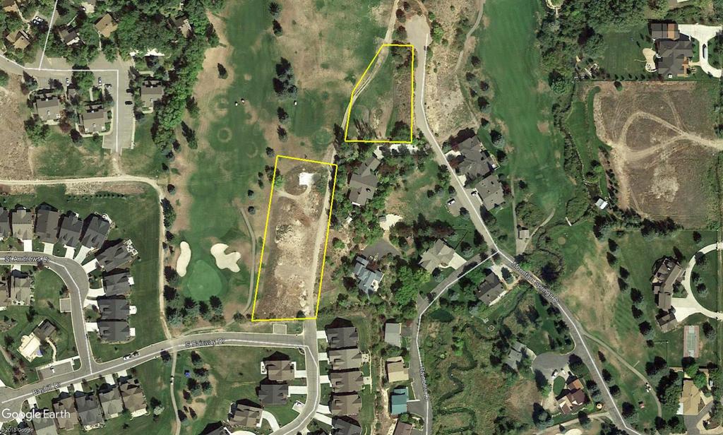
2 CITY COUNCIL MEETING STAFF REPORT DATE OF MEETING: January 15, 2018 NAME OF PROJECT: NAME OF APPLICANT: AGENDA ITEM: LOCATION OF ITEM: ZONING DESIGNATION: Homestead Villas: Phase 1 of the Homestead Resort Master Plan Homestead Legacy LLC Preliminary Bayhill Drive and Fairway Drive; Mountain Springs Drive R-1-15 ITEM: 8 Steve Eddington, agent for Legacy Homestead LLC, is requesting Preliminary Approval for a large-scale 4-lot subdivision known as the Homestead Villas (Phase 1 of the Homestead Resort Master Plan) on 1.81 acres. Three lots are located at the intersection of Bayhill Drive and Fairway Drive and the final lot is located near the cul-de-sac on Mountain Springs Drive. The property is in the R-1-15 zone. BACKGROUND: Legacy Homestead LLC is requesting approval of a four-lot subdivision that is phase 1 of the Homestead master plan that was approved on August 27, Three of the lots will access through The Links Planned Unit Development (PUD) from Bayhill Drive and Fairway Drive. The other lot will access through Swiss Creek PUD from Mountain Springs Drive. All the aforementioned streets are private, and easements have been provided proving access. Item 8 Preliminary 1
3 The three lots that access from The Links are about of third of an acre in size. They range from 13,605 square feet to 14,572 square feet. The lot that accesses from Mountain Springs Drive is larger at 26,968 square feet. This lot contains a 20 wide trail easement and public utility easement (PUE). All the proposed lots contain typical PUEs along the lot boundaries. The three contiguous lots will share a private driveway that will be maintained by the Homestead. Sumps will be installed in an easement on lot 1 that will collect the water run-off for the private driveway. R-1-15 zoning standards will govern all land uses on the three lots including setbacks for future structures. The lots are located along The Crater Springs Golf Course and are prone to golf ball hazards. Special consideration should be taken regarding building materials. Materials used for siding and windows should be resistant to errant golf balls. This proposal has been previously approved, but the final approval entitlement expired before the plat was recorded. The current configuration is modified from the layout in the exhibit that was approved with the master plan (see attached). The most notable difference is the shared driveway in the master plan connected the surrounding private streets. In the current proposal the driveways do not connect. The reason for the change is during previous approvals of this proposal the surrounding neighborhoods did not want the driveway to connect. This would have allowed for access that has not been possible because of a crash gate that currently blocks access at the south end of Fairway Drive. This proposal mirrors the most previous approval of the subdivision that recently expired. The Master Plan for the Homestead was previously amended by the developer and the City. These four lots, known as phase 1, were part of that Master Plan and were depicted on the Master Plan map as being part of a through road. The City Council granted final approval of the plans with the through road in November of The Home Owners Associations of the Links and Mountain Springs both objected to this configuration because of the through road. In December of 2008 the item was heard again by the City Council and lot 4 was reduced back to preliminary approval while the other three lots maintained their Final Approval status because of the issue of the through road. It was suggested by the city attorney in that meeting that if the two groups could not come to an agreement then two cul-de-sacs would be created to service the four lots with no through road. This proposal represents that suggestion. LAND USE SUMMARY: 1.81-acre site Proposal contains 4-lots in two plats; Lots 1, 2, and 3 in Plat A and Lot 4 in Plat B The parcels will be connected to the City s culinary water system and Midway Sanitation District s sewer system that both have mains located at the intersection of Fairway Drive and Bayhill Drive. Secondary water will be supplied through the Homestead s secondary irrigation system. Item 8 Preliminary 2
4 Lots 1, 2, and 3 will access from a private shared driveway that is an extension of Fairway Drive, a private street. Lot 4 will be accessed from Mountain Springs Drive on a driveway easement through Swiss Creek PUD Plat A. ANALYSIS: Roads and driveways there are no roads in the proposal only a shared private driveway. The driveway will be 20 wide and will have a turnaround as approved by the City Engineer and the Fire Chief. The driveway will be maintained by the Homestead. There are several easements that encumber the driveway that include access for emergency services, Homestead maintenance vehicles and the public. The driveway area, titled Common Area A is also a sewer and water easement. Trails an 8 paved trail is required to be built along the frontage of the Homestead on Homestead Drive. This will need to be built concurrently with the subdivision driveways. A bond will be required if the trail is not built before the plat is recorded. Dwelling construction materials the four lots are in an area where they will be prone to golf ball hazards. Staff has strongly recommended the building materials for the walls and windows are of materials that will withstand the impact of errant golf balls. There will be landscaping that will help deflect some of the potential errant golf balls, but the landscaping will not stop the dwellings from being hit. Access easements the applicant claims the ability to access the proposed subdivision through easements and agreements that have been recorded over the years. Three documents have been submitted to the City regarding this issue. The documents submitted to the City are the following: Declaration and Grant of Easement recorded on , Homestead Golf Course Master Agreement recorded on , and the Declaration of Covenants, Conditions and Restrictions for Mountain Springs PUD recorded on Landscaping plan the applicant has submitted a landscaping plan that covers property in and outside the proposed plat. The main reason for the landscaping is to help protect future structures from errant golf balls. The landscaping plan includes berms and a mix of trees. The landscaping plan will need to be included as part of any required bonding. Item 8 Preliminary 3
5 WATER BOARD RECOMMENDATION: Homestead Villas October 7, 2013 Motion: Irrigation Member Steve Farrell made a motion to reaffirm the motion made October 6,2008 that Homestead Villas is required to turn in 2.5 shares of water or 7.5 acre feet for four (4) single family homes. Council Member Dick Hines seconded the motion and it was carried unanimously. PLANNING COMMISSION RECOMMENDATION: Motion: Commissioner Bouwhius: I make a motion to approve the Homestead Villas, Phase 1 of the Homestead Resort Master Plan, for the preliminary approval of the largescale, 4-lot subdivision known as the Homestead Villas as recommended by staff findings. With the following conditions, that the Homestead frontage trail will be built concurrently with the shared driveway in the Homestead Villa Phase 1 (plat one), and a note on the plat is included that gives notice of errant golf balls and the potential safety and damage that could occur because of this hazard. The note will also reflect that sturdy construction materials are recommended that will withstand errant golf balls. Seconded: Commissioner O'Toole Chairman Kohler: Any discussion on the motion? Chairman Kohler: All in favor. Ayes: Commissioners: Streeter, Bouwhuis, Payne, Nicholas and O'Toole Nays: None Motion: Passed POSSIBLE FINDINGS: The Homestead Trail is required as part of Phase 1 of the Homestead master plan The Homestead Trail will be public and is a key component of the City s Master Trail Plan The proposal is part of the Homestead s entitled master plan Item 8 Preliminary 4
6 ALTERNATIVE ACTIONS: 1. Approval (conditional). This action can be taken if the City Council determines that conditions placed on the approval can resolve any outstanding issues. a. Accept staff report b. List accepted findings c. Place condition(s) 2. Continuance. This action can be taken if the City Council determines that there are unresolved issues. a. Accept staff report b. List accepted findings c. Reasons for continuance i. Unresolved issues that must be addressed d. Date when the item will be heard again 3. Denial. This action can be taken if the City Council determines that the request does not meet the intent of the ordinance. a. Accept staff report b. List accepted findings c. Reasons for denial RECOMMENDED CONDITIONS: 1. The Homestead frontage trail will be built concurrently with the shared driveway in the Homestead Villas Phase 1 (plat one). 2. A note on the plat is included that gives notice of errant golf balls and the potential safety and damage that could occur because of this hazard. The note will also reflect that sturdy construction materials are recommended that will withstand errant golf balls. Item 8 Preliminary 5
7
8
9 HOMESTEAD VILLAS PHASE 1 OF THE HOMESTEAD RESORT MASTER PLAN PRELIMINARY & FINAL APPLICATION SHEET INDEX 1. HOMESTEAD VILLAS PLAT 'A' PINE CANYON RD. CARI LANE BURGI LANE INTERLAKEN RD. RIVER ROAD 2. HOMESTEAD VILLAS PLAT 'B' 3. GOLF SHOT HAZARD MAP 4. LANDSCAPE PLAN 5. UTILITY PLAN HOMESTEAD VILLAS HOMESTEAD DR. PINE CANYON RD. CENTER ST. 600 NORTH RIVER ROAD 6. ROAD PLAN & PROFILE 7. ROAD CONSTRUCTION DETAILS 8. SEWER PLAN & PROFILE 9. SANITARY SEWER CONSTRUCTION DETAILS 10. CULINARY WATER CONSTRUCTION DETAILS 200 NORTH 11. STORM DRAIN PLAN MAIN ST. 12. STORM DRAIN CONSTRUCTION DETAILS 250 WEST S.H. 113 MIDWAY CITY VICINITY MAP THE HOMESTEAD HOMESTEAD VILLAS COVER SHEET E NGINEERING 380 E Main St. Suite 204 Midway, Ut ph SHEET DESIGN BY: PDB DATE:13 NOV 2018 DRAWN BY:PDB REV: 0
10 30' 0 30' 60' 90' Scale 1" =30'
11 30' 0 30' 60' 90' Scale 1" =30'
12 FUTURE LOT 4 TYPICAL GOLF SHOT SPRAY LOT FEET LOT 2 LOT YARD TYPICAL GOLF SHOT SPRAY 175 FEET THE HOMESTEAD HOMESTEAD VILLAS GOLF SHOT HAZARD MAP E NGINEERING 380 E Main St. Suite 204 Midway, Ut ph SHEET DESIGN BY: PDB DATE:13 NOV 2018 DRAWN BY:PDB REV: 3
13 FUTURE LOT 4 LOT 3 LOT 2 LOT 1 THE HOMESTEAD HOMESTEAD VILLAS LANDSCAPE PLAN E NGINEERING 380 E Main St. Suite 204 Midway, Ut ph SHEET DESIGN BY: CNB DATE:13 NOV 2018 DRAWN BY:CNB REV: 4
14 FUTURE LOT 4 LOT 3 LOT 2 LOT 1 THE HOMESTEAD HOMESTEAD VILLAS UTILITY PLAN E NGINEERING 380 E Main St. Suite 204 Midway, Ut ph SHEET DESIGN BY: PDB DATE:13 NOV 2018 DRAWN BY:PDB REV: 5
15 LOT 1 LOT 2 LOT 3 PRIVATE DRIVEWAY - TYPICAL SECTION LOT 4 THE HOMESTEAD HOMESTEAD VILLAS DRIVEWAY PLAN AND PROFIL E NGINEERING 380 E Main St. Suite 204 Midway, Ut ph SHEET DESIGN BY: PDB DATE:13 NOV 2018 DRAWN BY:PDB REV: 6

16 THE HOMESTEAD HOMESTEAD VILLAS ROAD CONSTRUCTION DETAIL E NGINEERING 380 E Main St. Suite 204 Midway, Ut ph SHEET DESIGN BY: PDB DATE:13 NOV 2018 DRAWN BY:PDB REV: 7
17 LOT 1 LOT 2 LOT 3 LOT 4 THE HOMESTEAD HOMESTEAD VILLAS SEWER PLAN AND PROFILE E NGINEERING 380 E Main St. Suite 204 Midway, Ut ph SHEET DESIGN BY: PDB DATE:13 NOV 2018 DRAWN BY:PDB REV: 8
18 THE HOMESTEAD HOMESTEAD VILLAS MSD STANDARD SEWER CONSTRUCTION DETAILS E NGINEERING 380 E Main St. Suite 204 Midway, Ut ph SHEET DESIGN BY: DATE:13 NOV 2018 DRAWN BY: REV: 9


19 THE HOMESTEAD HOMESTEAD VILLAS WATER CONSTRUCTION DETAILS ENGINEERING 380 E Main St. Suite 204 Midway, Ut ph DESIGN BY: DRAWN BY: DATE:13 NOV 2018 REV: SHEET 10
 FUTURE LOT 4 (0.")

20 LOT 1 (0.33 AC) LOT 2 (0.32 AC) DRAINAGE AREA A LOT 3 (0.39 AC) FUTURE LOT 4 (0.62 AC) THE HOMESTEAD HOMESTEAD VILLAS STORM DRAIN PLAN E NGINEERING 380 E Main St. Suite 204 Midway, Ut ph DESIGN BY: PDB DATE:13 NOV 2018 SHEET DRAWN BY:PDB REV: 11


21 18"x48" FRAME & GRATE RISER RISER HEIGHT CATCH BASIN 24" KNOCKOUTS THE HOMESTEAD HOMESTEAD VILLAS STORM DRAIN CONSTRUCTION DETAILS E NGINEERING 380 E Main St. Suite 204 Midway, Ut ph SHEET DESIGN BY: DATE:13 NOV 2018 DRAWN BY: REV: 12
22 The Links at the Homestead HOA Submitted January 7, 2019 The Links at the Homestead HOA ( The Links ) hereby submits comments and questions related to the application of Homestead Legacy LLC in connection with Phase 1 of the Homestead Resort Master Plan. Generally, we expect that the attached recommendations of Horrocks Engineers, entitled, The Homestead Villas Plat A & B. Preliminary Review, dated December 11, 2018, will be followed. If not, please let us know. Roads Discussion in the Midway planning committee meeting in December referred to the extension of Fairway Dr (north) as both a roadway and a private drive. Plans describe the extension as a private road. The summary of the Planning Committee meeting describes it as a driveway. Which is it? And does it make any difference. Is the end of the new Fairway extension going to be a hammer head dead end or a cul de sac dead end? The Planning Committee Meeting summary describes it as a cul de sac. In the Planning Committee meeting, a hammer head dead end was discussed and shown on the plan but Wes Johnson would prefer it be a cul de sac dead end. The Links strongly prefers a cul de sac for the reasons below. The Links is concerned about access for refuse trucks, utility vehicles, guests etc. if there is no adequate turn around at the end of the street. We feel there needs to be a turn around on this road which would result from making it a cul de sac. If not, then refuse trucks will not go down the street and, if they do, they will have to back out. It will create an unsafe situation where commercial vehicles are backing up in front of driveways where small children live. And, if refuse vehicles don t go down this street, then the new residents will have to take garbage cans to the entrance to the new road, which will be an eyesore. Curbs and gutters on both sides of the private road are necessary to minimize runoff. This was mentioned in the meeting as necessary, but it is not in the meeting summary. How does this affect storm drain calculations? We agree with the request by Horrocks that the maintenance gravel road or diversion of maintenance road does not need to be maintained since lots 1, 2 and 3 will now replace the area where the Homestead Golf Course keeps their extra landscape supplies (sand, soil, driving range equipment etc.). If it is still there, the maintenance road will most likely be used by individuals trying to find a shortcut around established roads which will most likely be Bayhill. Storm Drain Storm drain sumps should be reevaluated. Recalculate run off calculations and provide for the type of soil sumps to be constructed for the geographical features. Homes east and south of the sumps have basements and/or sharp drop offs. We feel it is very important to determine where the water will drain to and from the sumps. How will oil and other hazardous liquids runoff be handled if sumps overflow? Horrocks Engineers recommend a study be undertaken.
23 Additional Private Road questions We see no requirements for guest parking for the new private road. This should definitely be required. If not, we foresee problems with guests and visitors parking in the parking spaces The Links has constructed for their guests at the corner of Fairway and Bayhill. If cars in this new development were to park in The Links parking spaces, we would have such cars towed. Is a fire hydrant going to be installed on the new road? Will extension of Fairway Dr be open to public foot and bicycle traffic? The Links allows it and does not object to it being allowed on this new road. This will allow access to the trail system which is currently used by the public. We realize this is not part of the public trail system but Homestead Resort has been gracious enough to allow access and use. The Homestead Resort has approval to connect to public utilities running through The Links at the intersection of Bayhill and Fairway. After completion of utility connections, roadway and landscaping will be returned to their original condition. A road bond by Homestead Resort should be in place which will cover repaving of The Links roads and meets city engineer standards. This is from our conversations with Mr. Henke but we see no mention of it in the meeting summary. We want confirmation that this will be required. Landscaping A buffer or landscaping should be required where The Links property ends and lot #1 starts. Landscaping should be required which separates the developments and provides a visual barrier to The Links houses in that area. It is our understanding from the Planning Committee meeting that the public trail in front of the Homestead Resort along Homestead Dr is to be completed at the same time as completion of Phase 1. Please confirm. Summary of Actions taken We want to confirm the following decisions that were made by the Planning Committee and are contained in the meeting summary: R 1 15 zoning standards govern land use. Both Fairway Dr (north) and Mountain Springs Dr will be dead end roads. Easements will be in place for access to lots #1, 2 and 3 through The Links. However, there is no road access to lot #4 through The Links. Access to lot #4 will only be through Mountain Springs Dr. We will attend the January 15 City Council meeting to answer any questions the City Council or Mike Henke have concerning the above. Thank you for your consideration. HOA Board The Links at the Homestead HOA
24
Urban Planning and Land Use
 Urban Planning and Land Use 701 North 7 th Street, Room 423 Phone: (913) 573-5750 Kansas City, Kansas 66101 Fax: (913) 573-5796 Email: planninginfo@wycokck.org www.wycokck.org/planning To: From: City Planning
Roadway Classification Design Standards and Policies. Pueblo, Colorado November, 2004
 Roadway Classification Design Standards and Policies Pueblo, Colorado November, 2004 Table of Contents Page Chapter 1. General Provisions 1.1 Jurisdiction 3 1.2 Purpose and Intent 3 1.3 Modification 3
ACHD Board of Commissioners Stacey Yarrington, Planner III Tandem Ridge/ EPP / PP-07-16/ RZ-12-16/ CPA-01-16/ A-07-16
 Development Services Department DATE: December 14, 2016 TO: FROM: SUBJECT: ACHD Board of Commissioners Stacey Yarrington, Planner III Tandem Ridge/ EPP16-0012/ PP-07-16/ Executive Summary: This is an annexation,
REMOVE BARRIERS TO, ENCOURAGE CREATION OF AND PROVIDE GUIDELINES FOR SAFE ROUTES (ALL DISTRICTS)
") Ordinance 2009-98 AN ORDINANCE OF THE BOARD OF SUPERVISORS OF PIMA COUNTY, ARIZONA; RELATING TO ZONING; AMENDING THE PIMA COUNTY ZONING CODE TITLE 18 BY AMENDING SECTION 18.03.020 (DEFINITIONS) TO ADD
Ordinance 2009-98 AN ORDINANCE OF THE BOARD OF SUPERVISORS OF PIMA COUNTY, ARIZONA; RELATING TO ZONING; AMENDING THE PIMA COUNTY ZONING CODE TITLE 18 BY AMENDING SECTION 18.03.020 (DEFINITIONS) TO ADD
SECTION 3 STREET DESIGN
 3.01 GENERAL SECTION 3 STREET DESIGN For purposes of geometric and structural design, streets shall be classified according to the following table. The City Engineer will determine the class of all proposed
This Chapter sets forth the minimum design, technical criteria and specifications to be used in the preparation of all roadway plans.
 4.1 GENERAL This Chapter sets forth the minimum design, technical criteria and specifications to be used in the preparation of all roadway plans. These Roadway Standards are for new construction and modification
The Woods at Rush Creek - PUD Concept & Dvlpt Stage Plan Review
 .. - Cityof. Maple Grove Maple Grove Parks and Recreation MEMORANDUM TO: Peter Vickerman - City Planner FROM: Chuck Stifter - Director of Parks and Recreation ft ~ DATE: August: 12,2016 0 SUBJECT: The
STAFF REPORT TO THE PLANNING COMMISSION December 12,2016. Schuler Shoes PUD Concept and Development Stage Plan And Rezoning
 STAFF REPORT TO THE PLANNING COMMISSION December 12,2016 PUD Concept and Development Stage Plan And Rezoning Applicant: Owner: Requested Action: Location: Zoning: Edward Farr Architects Brad Neuerburg
Access requests to County streets and roadways are processed through one of the following methods:
 13.1 GENERAL APPLICATION PROCESS Access requests to County streets and roadways are processed through one of the following methods: A. Planned Developments may set general locations for access points.
Citizens Handbook for Requesting Traffic Calming Devices
 Citizens Handbook for Requesting Traffic Calming Devices January 19, 2015 Table of Contents 1. PURPOSE... - 1-2. DEFINITIONS... - 2-3. GENERAL INFORMATION... - 3-3.1. ELIGIBILITY REQUIREMENTS... - 3-3.2.
BPP / SUB
 Development Services Department Project/File: Lead Agency: Site address: Millwell Place Subdivision/ BPP15-0031/ SUB15-0064 This is a preliminary plat application to allow for the development of 68 building
Welcome to the Public Meeting. Red Hill Business Park South Transportation Master Plan Addendum. December 4, :00 p.m. to 8:00 p.m.
 Welcome Welcome to the Transportation Master Plan Addendum December 4, 2012 6:00 p.m. to 8:00 p.m. Please sign-in Background PIC#1 Public Information Centre #1 (PIC#1) was held on June 25, 2012. Feedback
Corpus Christi Metropolitan Transportation Plan Fiscal Year Introduction:
 Introduction: The Safe, Accountable, Flexible, Efficient Transportation Equity Act: A Legacy for Users (SAFETEA-LU) has continued the efforts started through the Intermodal Surface Transportation Efficiency
Villages of Pasadena Hills Financial Plan UPDATED Spring 2012 DRAFT
 36 37 38 39 40 41 42 43 44 45 46 Appendix B (Unchanged from January 2009 Adoption) 47 Projects Approved Prior to VOPH Comprehensive Plan Amendment Ashley Groves Chapel Creek Chapel Hill Farmington Hills
COUNTY OF SONOMA PERMIT AND RESOURCE MANAGEMENT DEPARTMENT 2550 Ventura Avenue, Santa Rosa, CA (707) FAX (707)
 FAX (707)") COUNTY OF SONOMA PERMIT AND RESOURCE MANAGEMENT DEPARTMENT 2550 Ventura Avenue, Santa Rosa, CA 95403 (707) 565-1900 FAX (707) 565-1103 DATE: February 17, 2012 TO: Board of Supervisors FROM: Blake Hillegas,
COUNTY OF SONOMA PERMIT AND RESOURCE MANAGEMENT DEPARTMENT 2550 Ventura Avenue, Santa Rosa, CA 95403 (707) 565-1900 FAX (707) 565-1103 DATE: February 17, 2012 TO: Board of Supervisors FROM: Blake Hillegas,
Atwood Avenue Fair Oaks Avenue Cottage Grove Road
 Atwood Avenue Fair Oaks Avenue Cottage Grove Road Agenda Purpose Review project scope & goals Present design alternatives Gather feedback Answer Questions Format Open House Presentation Q&A Open House
CITY OF ROSEVILLE DESIGN STANDARDS
 CITY OF ROSEVILLE DESIGN STANDARDS Section 1 Purpose and Definitions 1-1 Purpose PD 1 1-2 Design Practice PD 1 1-3 Definitions PD 1 Section 2 General Requirements 2-1 Plans by an Appropriate Engineer GR
 Development Services Department Project/File: Lead Agency: Site address: Fall Creek Subdivision (MPP-12-016) This is a preliminary plat application to subdivision approximately 110 acres into 296 residential
Spartanburg County Planning and Development Department
 Spartanburg County Planning and Development Department MINUTES Planning and Development Commission County Council Chambers, 4:30 p.m. August 8, 2017 Members Present: Whit Kennedy, Chairman Toby McCall,
M I N U T E S OKLAHOMA COUNTY PLANNING COMMISSION
 M I N U T E S OKLAHOMA COUNTY PLANNING COMMISSION September 21, 2000 1:30 P.M. The meeting of the Oklahoma County Planning Commission convened and was called to order by Ms. Cheryl Dorrance, at 1:30 P.M.,
CITY OF CHARDON PLANNING COMMISSION Meeting Minutes May 16, Jim Gillette, Law Director Steve Yaney, Planning and Zoning Administrator
 CITY OF CHARDON PLANNING COMMISSION Meeting Minutes May 16, 2016 Members Present: Andrew Blackley, Vice-Chairman Chris Grau Al Hunziker Kenneth Miller, Chairman Dan Meleski James Pruce Mary Jo Stark Members
Brooklyn Boulevard (County Road 152) Reconstruction Project Phase I. OPEN HOUSE June 20, 2017
 Reconstruction Project Phase I. OPEN HOUSE June 20, 2017") Brooklyn Boulevard (County Road 152) Reconstruction Project Phase I OPEN HOUSE June 20, 2017 Brooklyn Boulevard (County Road 152) Phase I Project Partners Project Lead Other Project Partners include Brooklyn
Brooklyn Boulevard (County Road 152) Reconstruction Project Phase I OPEN HOUSE June 20, 2017 Brooklyn Boulevard (County Road 152) Phase I Project Partners Project Lead Other Project Partners include Brooklyn
3/10/2016 VIA th Street, Suite 203 Sacramento, CA
 3/10/2016 VIA EMAIL Arwen Wacht, Associate Planner City of Sacramento Community Development Department 300 Richards Boulevard, 3 rd Floor Sacramento, CA 95811 RE: Natomas Fountains (P16-012) Dear Ms. Wacht:
Preliminary Engineering Study
 Preliminary Engineering Study Open House # 2 June 6, 2018 PREPARED FOR: PREPARED BY: Agenda Background and status of preliminary engineering study County Road 26 design summary County Road 63 design summary
West Dimond Blvd Upgrade Jodhpur Street to Sand Lake Road
 West Dimond Blvd Jodhpur St to Sand Lake CSS Transportation Project Summary Municipality of Anchorage Project # 05 005 Project Manager: John Smith, P.E. (MOA PM&E) Project Administrator: Julie Makela,
Planning & Zoning Commission
 Preliminary Plat Westwood, Section 3 Planning & Zoning Commission Planning & Development Department March 21, 2016 Request Subdivide approximately 38.1 acres of previously unplatted property to create
Building Great Neighbourhoods BONNIE DOON
 Building Great Neighbourhoods BONNIE DOON We Are Here Today To Explain the Neighbourhood Renewal Process Show you the Westwood Preliminary Design Ask for local knowledge Highlight the Local Improvement
T A B L E OF C O N T E N T S
 T A B L E OF C O N T E N T S PART III SUBDIVISION REGULATIONS OF THE DEPARTMENT OF PUBLIC WORKS, C & C D PAGE PAGE Responsibility for Development of Streets......... 29 Right-of-Way Widths...... 37 Purpose...........
4APNOIPF Vh, YII PTC CITY COUNCIL AGENDA REPORT. Honorable Mayor and City Council Members. 8K TH 63 River Crossing Bridge Replacement Project
 City of RE 4APNOIPF Vh, X` W\ YII PTC ING, CITY COUNCIL AGENDA REPORT Council Meeting Date: September 26, 2016 To: From: Agenda Item: Honorable Mayor and City Council Members Ron Rosenthal, Engineering
ORDINANCE NO AMENDMENT TO ORDINANCE NO NASSAU COUNTY, norida. WHEREAS, on the 28th day of January, 1991, the Board of County
 ORDINANCE NO. 99-23 AMENDMENT TO ORDINANCE NO. 91-04 NASSAU COUNTY, norida WHEREAS, on the 28th day of January, 1991, the Board of County Commissioners, Nassau County, Florida (the "Board"), did adopt
This chapter describes the proposed circulation system and transportation alternatives associated with
 5.0 Circulation 5.1 OVERVIEW This chapter describes the proposed circulation system and transportation alternatives associated with West Landing, and summarize the information contained in the Existing
November 13, Planning and Land Development Regulation Commission (PLDRC)
") 1 of 29 GROWTH AND RESOURCE MANAGEMENT DEPARTMENT PLANNING AND DEVELOPMENT SERVICES DIVISION CURRENT PLANNING ACTIVITY 123 W. Indiana Avenue, DeLand, FL 32720 (386) 943-7059 PUBLIC HEARING: CASE NO: SUBJECT:
1 of 29 GROWTH AND RESOURCE MANAGEMENT DEPARTMENT PLANNING AND DEVELOPMENT SERVICES DIVISION CURRENT PLANNING ACTIVITY 123 W. Indiana Avenue, DeLand, FL 32720 (386) 943-7059 PUBLIC HEARING: CASE NO: SUBJECT:
Development Services Department
 Kent Goldthorpe, President Paul Woods, Vice President Rebecca W. Arnold, Commissioner Sara M. Baker, Commissioner Jim D. Hansen, Commissioner July 21, 2016 Development Services Department To: From: ACHD
POLICY REVIEW SUMMARY
 E POLICY REVIEW SUMMARY The project team reviewed planning and design standards for each community in the region. The following tables summarize the relevant code in these documents that pertains to the
Napa County Planning Commission Board Agenda Letter
 Agenda Date: 8/17/2016 Agenda Placement: 9D Napa County Planning Commission Board Agenda Letter TO: FROM: Napa County Planning Commission John McDowell for David Morrison - Director Planning, Building
Town of Siler City - Unified Development Ordinance ARTICLE XIV - Streets and Sidewalks
 ARTICLE XIV - Streets and Sidewalks 193 Street Classification (a) In all new subdivisions, streets that are dedicated to public use shall be classified as provided in 193(b) (1) The classification shall
Exhibit 1 PLANNING COMMISSION AGENDA ITEM
 Exhibit 1 PLANNING COMMISSION AGENDA ITEM Project Name: Grand Junction Circulation Plan Grand Junction Complete Streets Policy Applicant: City of Grand Junction Representative: David Thornton Address:
11/28/2016 VIA
 11/28/2016 VIA EMAIL Ethan Meltzer, Assistant Planner City of Sacramento Community Development Department 300 Richards Blvd., 3 rd Floor Sacramento, Ca 95811 RE: Natomas Corporate Center Commercial Building
CSAH 101 Preliminary Design
 CSAH 101 Preliminary Design Public Open House No. 2 January 29, 2013 CSAH 62 to Hutchins Drive Welcome / Introductions Hennepin County Craig Twinem, Transportation Maury Hooper, Transportation Nick Peterson,
Development Services Department
 Kent Goldthorpe, President Paul Woods, Vice President Rebecca W. Arnold, Commissioner Sara M. Baker, Commissioner Jim D. Hansen, Commissioner July 28, 2016 Development Services Department To: From: ACHD
DRAFT - CITY OF MEDFORD TRANSPORTATION SYSTEM PLAN Roadway Cross-Sections
 Roadway Cross-Sections Medford s roadway cross-section standards apply to new and reconstructed roads. The crosssections take into consideration roadway function and operational characteristics, including
122 Avenue: 107 Street to Fort Road
 : 107 Street to Fort Road November 24, 2015 4:30 8:00 p.m. Meeting Purpose Summarize project work completed to date Share results of public input from Phase 1 Share the draft concept plan and proposed
Designed for Drivability
 Designed for Drivability cenews.com /article/10191/designed-for-drivability October 2015» Project + Technology Portfolio» Residential Vehicle flow is a critical component at the neighborhood level of design.
AGENDA REPORT. Issue: Discussion of potential improvements on Barnwell Road at Niblick Drive
 AGENDA REPORT To: From: By: Honorable Mayor and City Council Members Warren Hutmacher, City Manager Tom Black, Public Works Director Date: March 23, 2016 Agenda: March 28, 2016 WORK SESSION AGENDA: Barnwell
2014 Street and Utility Improvement Project. Feasibility Report January 28, 2014
 2014 Street and Utility Improvement Project Feasibility Report January 28, 2014 Public Informational Meeting 22 residents from 17 properties signed in Questions about construction (FAQs) Eyebrow cul-de-sac
TOWNSHIP OF DERRY BOARD OF SUPERVISORS MEETING
 TOWNSHIP OF DERRY BOARD OF SUPERVISORS MEETING Tuesday, May 12, 2009 600 Clearwater Road, Hershey, Pennsylvania 17033 CALL TO ORDER The May 12, 2009 Township of Derry Board of Supervisors meeting was called
NEIGHBORHOOD TRAFFIC CALMING POLICY
 NEIGHBORHOOD TRAFFIC CALMING POLICY I. PURPOSE The City of Kent continually strives to strengthen and protect its neighborhoods by improving the quality of life in residential areas. Traffic conditions
NARRATIVE FOR SERENITY HILL OF HALSTED BAY SERENITY HILL OF LAKE MINNETONKA, LLC
 NARRATIVE FOR SERENITY HILL OF HALSTED BAY SERENITY HILL OF LAKE MINNETONKA, LLC January 31, 2016 Written statements providing information regarding your proposal. Please provide a separate answer for
Vicinity Map. Proposed Roosevelt Street Sidewalk Project OVERLAND ROAD TO CASSIA STREET W ROSE HILL ST W ALBION ST S OWYHEE ST W CASSIA ST
 Vicinity Map W ROSE HILL ST Cassia Park W CAMAS ST LEGEND W ALBION ST S ROOSEVELT ST W CASSIA ST Sacred Heart W KOOTENAI ST Monroe Elementary S OWYHEE ST South Junior High S SHOSHONE ST Project area Bus
WHEREAS delivery trucks also pass through the Narrows, into the northern parking lot, to loading docks in the back of the building.
 CEDAR-ISLES-DEAN NEIGHBORHOOD ASSOCIATION ( CIDNA ) RESOLUTION OPPOSING A DRUG STORE DRIVE THRU, AND COMMENDING DORAN COMPANIES FOR PROPOSING MITIGATING AMENITIES INCLUDING NEW LANDSCAPING AND A DEDICATED
Board of Supervisors February 27, 2017
 : Traffic Analysis Results & Draft Conceptual Plan Board of Supervisors February 27, 2017 Transportation Solutions Building Better Communities Presentation Overview Background Summary of Traffic Analysis
12/4/2016 VIA . RE: Grocery Outlet Del Paso (DR16-328)
") 12/4/2016 VIA EMAIL Ethan Meltzer, Assistant Planner City of Sacramento Community Development Department 300 Richards Blvd, 3 rd Floor Sacramento, CA 95811 RE: Grocery Outlet Del Paso (DR16-328) Dear Mr.
12/4/2016 VIA EMAIL Ethan Meltzer, Assistant Planner City of Sacramento Community Development Department 300 Richards Blvd, 3 rd Floor Sacramento, CA 95811 RE: Grocery Outlet Del Paso (DR16-328) Dear Mr.
Street Paving and Sidewalk Policy
 City Commission Policy 600 Street Paving and Sidewalk Policy DEPARTMENT: Public Works DATE ADOPTED: June 7, 1995 DATE OF LAST REVISION: December 10, 2014 Policy No. 600.01 AUTHORITY: PASS City of Tallahassee-Leon
Fields of St. Croix HOA Meeting. October 27, 2016
 Fields of St. Croix HOA Meeting October 27, 2016 Welcome! Why are we here? Update on Manning Avenue Phase 2 Project: Project Design Schedule Project Background Importance of Manning Avenue: Primary north-south
September 18, Mr. Matthew Morris Kolter Acquisitions, LLC 6981 Professional Parkway E. Sarasota, Florida Dear Mr.
 JIM C. STUDIALE Director Community Development Department September 18, 2014 Mr. Matthew Morris Kolter Acquisitions, LLC 6981 Professional Parkway E. Sarasota, Florida 34240 RE: Minor Modification of PUD
NEIGHBORHOOD TRAFFIC CALMING PROGRAM. Policy and Procedure. Roswell Department of Transportation (770)
") NEIGHBORHOOD TRAFFIC CALMING PROGRAM Policy and Procedure Roswell Department of Transportation (770) 594 6420 Approved by M&CC on December 19, 2011 Table of Contents 1. Application and Intent 2. Program
NEIGHBORHOOD TRAFFIC CALMING PROGRAM Policy and Procedure Roswell Department of Transportation (770) 594 6420 Approved by M&CC on December 19, 2011 Table of Contents 1. Application and Intent 2. Program
County of Greenville South Carolina. Traffic Calming Program Neighborhood Traffic Education Program and Speed Hump Program
 County of Greenville South Carolina Traffic Calming Program Neighborhood Traffic Education Program and Speed Hump Program (rev) August 2008 I. PURPOSE The potential negative impacts from vehicular traffic
TOWN OF MARANA. Subdivision Street Standards Manual
 TOWN OF MARANA Subdivision Street Standards Manual May 2013 TABLE OF CONTENTS CHAPTER & SECTION 1.0 INTRODUCTION AND PURPOSE. 1 1.1 Introduction 1 1.2 Purpose... 1 1.3 Applicability.. 2 2.0 FUNCTIONAL
GARLAND ROAD/GASTON AVENUE/ GRAND AVENUE INTERSECTION IMPROVEMENT STUDY
 MEETING OF AFFECTED PROPERTY OWNERS AND STAKEHOLDERS GARLAND ROAD/GASTON AVENUE/ GRAND AVENUE INTERSECTION IMPROVEMENT STUDY CSJ 0009-02-067 Meeting Agenda 1 2 3 4 5 6 7 8 9 10 Opening Remarks State Representative
TABLE OF CONTENTS. 1.0 INTRODUCTION AND PURPOSE Introduction Purpose Applicability.. 2
 TABLE OF CONTENTS CHAPTER & SECTION 1.0 INTRODUCTION AND PURPOSE. 1 1.1 Introduction 1 1.2 Purpose... 1 1.3 Applicability.. 2 2.0 FUNCTIONAL CLASSIFICATION AND REGULATIONS.. 2 2.1 Functional Classification....
STATE OF VERMONT ENVIRONMENTAL COURT } } } } } Decision and Order
 STATE OF VERMONT ENVIRONMENTAL COURT In re: Appeal of Ted S. Gladstone and Kathleen Hoisington Docket No. 190-10-99 Vtec Decision and Order Appellants appealed from a decision of the Planning Commission
 Development Services Department Project/File: Lead Agency: Site address: Applicant: Memory Ranch / KPP15-0003 / 15-02-AN / 15-01-S The applicant is requesting annexation of approximately 10 acres, rezoning
Single Family Detached District Summary of Allowable Uses
 Single Family Detached District Summary of Allowable Uses (Please refer to Section 18-160 for the most up-to-date list: Section 18-160) Accessory Uses Accessory community center private (SUP) Accessory
1 PLANNING BOARD COUNTY OF ALBANY
 1 PLANNING BOARD COUNTY OF ALBANY 1 2 TOWN OF COLONIE 3 ***************************************************** LESH SUBDIVISION 4 241 SAND CREEK ROAD SKETCH PLAN REVIEW 5 *****************************************************
David Hung, Associate Planner City of Sacramento Community Development Department 300 Richards Boulevard, 3 rd Floor Sacramento, CA
 June 13, 2016 VIA EMAIL David Hung, Associate Planner City of Sacramento Community Development Department 300 Richards Boulevard, 3 rd Floor Sacramento, CA 959811 RE: Fire Station 14 (DR16-128) Dear Mr.
10A. DATE: October 5, Pedestrian and Bicycle Advisory Committee. Kevin Colin, Deputy Planning Manager Curt Bates, City Engineer
 10A DATE: October 5, 2016 TO: PREPARED BY: SUBJECT: Pedestrian and Bicycle Advisory Committee Kevin Colin, Deputy Planning Manager Curt Bates, City Engineer Discussion and Provide Comments, Associated
REPORT. Engineering and Construction Department
 REPORT COMMUNITY SERVICES COMMITTEE MEETING DATE: JUNE 11, 2013 FROM: Engineering and Construction Department DATE: May 24, 2013 SUBJECT: Great Lakes Boulevard Mini Roundabout LOCATION: Great Lakes Boulevard
DBA 65, 34684, 6:00 P.M.
 The Lake St. George South Homeowners Association, Inc. D.B.A. The Courts of Lake St. George A Corporation Not-for-profit Minutes of Special Board Meeting The Special Board of Directors Meeting of The Lake
BOI / DRH S. 13 th Street Mixed use office/retail development with residential dormitory
 Jim D. Hansen, President Sara M. Baker, Vice President Rebecca W. Arnold, Commissioner Kent Goldthorpe, Commissioner Paul Woods, Commissioner October 21, 2015 To: Rick Nesser ISS River Partners, LLC 8312
FENCE PERMIT APPLICATION
 OFFICE USE ONLY FENCE PERMIT APPLICATION PROCESS & REVIEW FEES $15 (GL#310) Cash or Check Only Approved Denied 110 S. MAIN STREET SPRINGVILLE, UT 84663 801.491.7861 www.springville.org Reviewed by: Print
SR-203 Sidewalks and Town-Wide Mobility Improvements. Town Council Presentation September 7, 2016
 SR-203 Sidewalks and Town-Wide Mobility Improvements Town Council Presentation September 7, 2016 SR-203 Sidewalks and Town- Wide Mobility Improvements SR-203 Sidewalks and Appurtenances Town-Wide Mobility
CITY OF MEDINA PLANNING COMMISSION Meeting Minutes Tuesday, June 12, 2012
 CITY OF MEDINA PLANNING COMMISSION Meeting Minutes Tuesday, June 12, 2012 1. Call to Order: Commissioner Charles Nolan called the meeting to order at 7:00 p.m. Present: Planning Commissioners Charles Nolan,
PennDOT Access Management Model Ordinances Training
 PennDOT Access s Training Trainers: Chad Dixson, AICP, TPD Angela Watson, PB Objective of Today Assist Pennsylvania s municipalities and transportation professionals in better understanding the benefits
Table of Contents City of Shelbyville Unified Development Ordinance
 City of Shelbyville Unified Development Ordinance 2012, Bradley E. Johnson, AICP Table of Contents 1: Ordinance Foundation 1.01 Title... 1-2 1.02 Unified Development Ordinance... 1-2 1.03 Defined Words...
Bradford s Landing. Preliminary Plan Abandonment AB753 & AB754 MONTGOMERY COUNTY PLANNING DEPARTMENT
 Bradford s Landing Preliminary Plan 120170060 Abandonment AB753 & AB754 1 Overview Staff recommends Approval of Preliminary Plan 120170060 with revised conditions and Adoption of the Resolution. 244 lots
NORTH HIGHLAND LAKE ROAD PROJECT
 NORTH HIGHLAND LAKE ROAD PROJECT The purpose of this special newsletter is to inform the residents of Flat Rock about the facts concerning the proposed N. Highland Lake Road Project and clarify some misconceptions.
MAJOR THOROUGHFARE PLAN
 MAJOR THOROUGHFARE PLAN Adopted by City Commission On November 21, 2005 Per Resolution No. 4420 Amendment to the Comprehensive Community Development Plan City of Hobbs City of Hobbs MAJOR THOROUGHFARE
CITY OF VAUGHAN EXTRACT FROM COUNCIL MEETING MINUTES OF OCTOBER 30, 2012
 CITY OF VAUGHAN EXTRACT FROM COUNCIL MEETING MINUTES OF OCTOBER 30, 2012 Item 31, Report No. 39, of the Committee of the Whole, which was adopted without amendment by the Council of the City of Vaughan
12/13/2018 VIA
 12/13/2018 VIA EMAIL Daniel Abbes, Assistant Planner City of Sacramento community Development Department 300 Richards Blvd., 3 rd Floor Sacramento, CA 95811 RE: Bruceville Apartments (P18-073) Dear Mr.
JACKRABBIT DEVELOPMENT
 JACKRABBIT DEVELOPMENT Now available in 4 parcels ranging from 50 to 79 acres and starting at $2.95M JACKRABBIT DEVELOPMENT County: Gallatin Location: Belgrade, MT NW 70± Acres (Top Left) $3.75M MLS#
Committed to Service
 Committed to Service Paul Woods, President Rebecca W. Arnold, Vice President Sara M. Baker, Commissioner Jim D. Hansen, Commissioner Kent Goldthorpe, Commissioner September 19, 2017 Development Services
IH 20 RANGER HILL PUBLIC MEETING
 IH 20 RANGER HILL PUBLIC MEETING AUGUST 25, 2015 IH 20, Eastland County, TX CSJ 0007-06-084 IH 20 from 3.5 mi. East of LP 254 to SH 16 (Ranger Hill) August 25, 2015 Agenda Introductions Purpose of the
Lee s Summit Road Improvement Study Public Open House June 7, 2007 Summary of Comment Card Responses
 Lee s Summit Road Improvement Study Public Open House June 7, 2007 Summary of Comment Card Responses Introduction At the Lee s Summit Road Improvement Study Public Open House held Thursday, June 7, 2007
ARLINGTON COUNTY, VIRGINIA
 ARLINGTON COUNTY, VIRGINIA County Board Agenda Item Meeting of October 15, 2016 DATE: October 7, 2016 SUBJECT: Adoption of amendments to the Master Transportation Plan (MTP) to create a new Pedestrian
Ordinance No ORDINANCE NUMBER 238
 Ordinance No. 238 1 ORDINANCE NUMBER 238 BY THE ADA COUNTY HIGHWAY DISTRICT BOARD OF COMMISSIONERS: SARA M. BAKER, REBECCA W. ARNOLD, JIM D. HANSEN, KENT GOLDTHORPE, PAUL WOODS AN ORDINANCE AMENDING TITLE
Inspector MUST Sign and Date Each Inspection
 Work Area: Applicant: Mercer County Department of Transportation - Highways Division Application and Permit for Road Work in Mercer County, New Jersey NO. East Windsor Ewing Hamilton Hopewell Lawrence
EXHIBIT R1. Neighborhood Cul-de-Sac Implementation
 Neighborhood Cul-de-Sac Implementation The traffic study conducted for the Talaria project analyzed the amount of project traffic expected to use local, residential streets immediately north of the project
BPP / SUB /CAR /PUD
 Development Services Department Project/File: Lead Agency: Site address: Roe Street Townhomes/ BPP16-0023/ SUB16-00046/CAR16-00023/PUD16-00022 This is a rezone, preliminary plat, and planned unit development
Town of Kiawah Island Board of Zoning Appeals
 Town of Kiawah Island Board of Zoning Appeals March 19, 2018 Town of Kiawah Island Municipal Center 4475 Betsy Kerrison Parkway Kiawah Island, SC 29455 CASE# BZA-12-17-00233 Applicant/Property Owner(s):
LARIMER COUNTY: ENGINEERING DOUGLAS ROAD (CR 54)
") LARIMER COUNTY: ENGINEERING DOUGLAS ROAD (CR 54) INTRODUCTIONS * Pipeline 1041 Application Coordinator Todd Blomstrom Public Works Director Mark Peterson County Engineer Terry Gilbert Community Development
LARIMER COUNTY: ENGINEERING DOUGLAS ROAD (CR 54) INTRODUCTIONS * Pipeline 1041 Application Coordinator Todd Blomstrom Public Works Director Mark Peterson County Engineer Terry Gilbert Community Development
SAN FRANCISCO MUNICIPAL TRANSPORTATION AGENCY BOARD OF DIRECTORS. RESOLUTION No
 SAN FRANCISCO MUNICIPAL TRANSPORTATION AGENCY BOARD OF DIRECTORS RESOLUTION No. 15-031 WHEREAS, Transportation Code Division II, Section 909 authorizes the Director of Transportation to install and permit
a 20 year period. separate phases of development with staggered years)
") Proposed: Approximately 2,000 acres located at along SH 130 at FM 973 Mixed Use project consisting of : Residential i Approximately 2,800 single family detached units Approximately 2,000 attached units
Proposed: Approximately 2,000 acres located at along SH 130 at FM 973 Mixed Use project consisting of : Residential i Approximately 2,800 single family detached units Approximately 2,000 attached units
Subdivision Staff Report
 Subdivision Staff Report Subdivision Name Plano Road Subdivision File Number SUB07-00065 Approval Preliminary Plat Lead Agency Boise City Annexation Date Pending (CAR07-00042/DA) Comp. Plan Does Not Comply
Committed to Service. Development Services. February 21, ACHD Commission. Mindy Wallace, AICP
 Committed to Service Sara M. Baker, President Rebecca W. Arnold, Vice President Jim D. Hansen, Commissioner Kent Goldthorpe, Commissioner Paul Woods, Commissioner February 21, 2018 Development Services
Traffic Calming Policy
 City of Friendswood Traffic Calming Policy May 2012 Community Development Department Table of Contents Title Page Table of contents... 1 Background and History... 2 Purpose and Goals... 2 City Procedure
Poor pavement condition Substandard Intersections. / Substandard bike/pedestrian/transit accommodations. Driveway access Environmental concerns
 Public Informational Meeting University Avenue (Allen Boulevard Segoe Road) March 23, 2011 City of Madison City of Middleton Village of Shorewood Hills Dane County Existing Roadway Conditions Poor pavement
NEW BUSINESS CITY PLANNING COMMISSION AGENDA ITEM NO: 4 STAFF: STEVE TUCK FILE NO: CPC UV QUASI-JUDICIAL
 Page 47 NEW BUSINESS CITY PLANNING COMMISSION AGENDA ITEM NO: 4 STAFF: STEVE TUCK FILE NO: CPC UV 08-00154 QUASI-JUDICIAL PROJECT: APPLICANT: OWNER: GENERAL OR MEDICAL OFFICE AT 1730 NORTH CORONA STREET
Year GRANITE RIDGE. City of Fishers Planned Development Ordinance # v
 GRANITE RIDGE v.03.09.15 City of Fishers Planned Development Ordinance # 020215 1.01 Declaration, Purpose and Intent, and Permitted Uses Declaration Ordinance No. 020215 ("this Ordinance") Adopted: The
Provides an extension of a road to the subdivision boundary or parcel to facilitate the continuity of possible adjacent development.
 SECTION 2 - ROADWAYS 2-1 Continuity of the Public Road System The continuity of a publicly maintained system is a prerequisite to the addition of any street into the County road system. A road or street
SD Highway 50 in Yankton (4 TH Street) Reconstruction Project NH 0050(99)381 PCN By Josh Larson McLaury Engineering Inc.
 Reconstruction Project NH 0050(99)381 PCN By Josh Larson McLaury Engineering Inc.") SD Highway 50 in Yankton (4 TH Street) Reconstruction Project NH 0050(99)381 PCN 6926 By Josh Larson McLaury Engineering Inc. Project Limits SD 50 from Broadway to Burleigh and from Marne Creek to Archery
SD Highway 50 in Yankton (4 TH Street) Reconstruction Project NH 0050(99)381 PCN 6926 By Josh Larson McLaury Engineering Inc. Project Limits SD 50 from Broadway to Burleigh and from Marne Creek to Archery