Case South Lamar the southeast portion of the expanded Callicutt Farms abutting the Azalea Planned Unit Development
|
|
|
- Jonas Gray
- 5 years ago
- Views:
Transcription

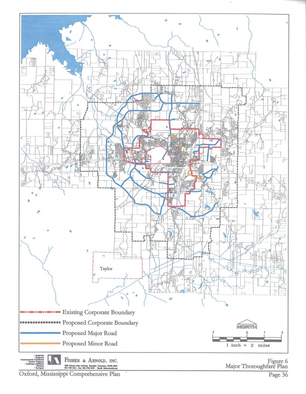
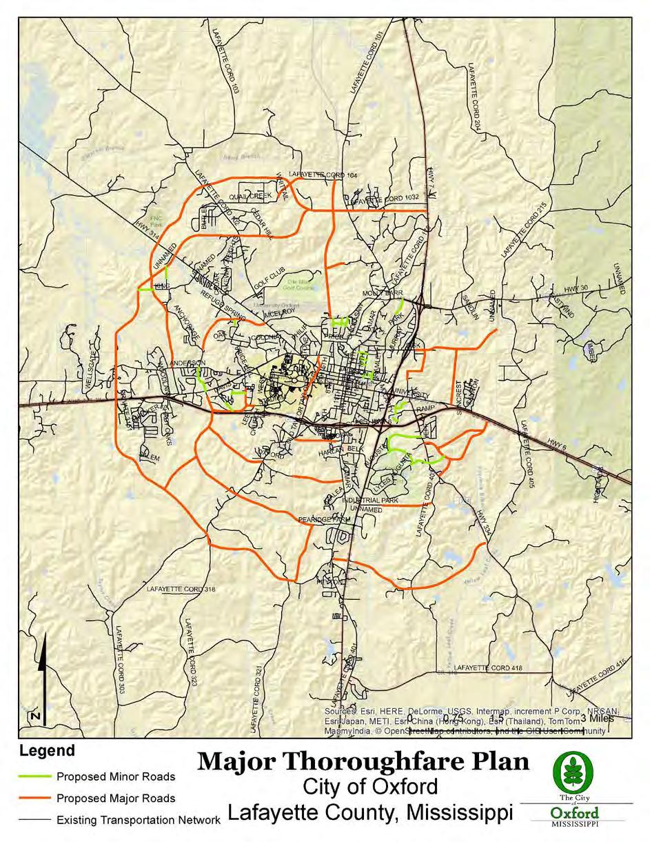
1 Case 1887 Applicant: Owners: Request: Location: Andy Callicutt Same Conditional Rezoning of Property from (A) Agricultural to Professional Business part of the expanded master planned Callicutt Farms South Lamar the southeast portion of the expanded Callicutt Farms abutting the Azalea Planned Unit Development Zoning Agricultural Zoning History: Zoning established in 2004 Part of the Comprehensive Land Use amendment to Mixed Use 2014 Surrounding: North: Recently developing (PB) Professional Business Zoning containing the Oxford Pediatric Practice and the Callicutt Professional Park South: Medical Offices with frontages on Azalea (PUD) East: Office Park Drive (developed with medical and other offices) West: Vacant land proposed for the YMCA currently zoned Agricultural Planner s Comments: The property is located in the proposed expanded Callicutt Farms project. As shown in the attached Callicutt Farms booklet this property is intended to develop in similar fashion of the other PB piece developing to the north. The change and need is directly related to the development of the new Baptist Hospital and the associated new roads and need for support mixed use. The Hospital property is slated to develop as a medical district. The Hospital Campus is north of the proposed Callicutt Farms. There is an immediate need for doctor s offices in close proximity to the Hospital. The City s major transportation plan indicates an east-west collector roadway through the property designated to connect Old Taylor Road with South Lamar Boulevard. Also, as with the approval of Baptist Hospital, there will be a north-south connector road that ties the Hospital Campus to the Callicutt Farms Community. Please see attached the major Thoroughfare Plan from the Comprehensive Plan which documents the extension of 300 across the Callicutt Property to South Lamar. The request to site professional offices is consist with development, land use and zoning in the area. Recommendation: Conditional rezoning to Professional Business for area 7 a 4.28-acre tract limited to the following permitted uses: 1
2 1. Professional offices, including offices of physicians, dentists, lawyers, engineers, architects, accountants, and similar professions, which generate a minimum amount of traffic [and] at which no products, except those normally associated with the above offices, are sold retail, wholesale, or otherwise. 2. Commercial condominiums, See section , Condominiums, limited to uses mentioned in section (1), above. 3. Public park and/or playground. 4. Accessory use, as defined in section Agriculture, limited to use and/or enjoyment by occupants of the premises; no livestock or poultry, except horses for pleasure. A minimum of one acre of pasture per animal must be available for horses for pleasure. USES PERMTTED TO REQUEST SPECAL EXCEPTON: 1. Retail and service businesses directly related to the professional offices permitted in such zone, including, but not limited to, pharmacies, medical services, technical schools, nursing homes, hospitals, office supply, and other similar uses. 2. Church and/or church facilities, minimum lot size of one acre. 3. Public facilities and/or utility facilities necessary to provide service to the surrounding area, or to the entire municipality. 2
3 @ City of Oxford 107 Courthouse Square Oxford, MS APPLCATO~ FOR ZONNG MAP A1'\'1E.:'llDME~T Ap11lican1's Name _A_n_d_y_C_a_l_lic_u_t_t _ Mailing Address 3883 Majestic Oaks. Oxford, MS Address of Property in Question South Lamar Bou levard ~ Telephone Number (s) Day (662) ~ nterest in Propcrty@>wner QLeaseholde10ption to PurchascOther Legal fnterest Present Zoning Classification of Property Proposed Zoning Classification of Property _ Legal Descriptic>n of l'roperty (nclude all subdivision lot numbers or metes and bounds description and tax parcel numbers) Seo Anaclvno" A What changed or changing condilions make the passage of this!lmendmenl necessary? See Anacttmon1 Band BoolU What other circumstances justify the proposed change? See AtlachmoM B and Booklet What error(s), if any, in the Zoning Map would be corrected by the proposed amendment? No errors ln ZOf'llng map assoclatod W\lh U1is amondmont A. legal description and a plat showing the la d area rrected by the proposed amendment, zoning ch1ssification of the area and nil obutting properties, all public and pr1v te rights-of-way and ea.sements bounding and int ersecting the designated area and abutting properties must be attached along with a SS0.00 nling fee payable to the City of Oxford. FOR CTY USE ONLY Date Filed Filing Fee $ Dale of Public Hearing Decision of Board of Adjustment Effective Date Zoning Administrator Dntc

4 Area 7 P-B Destription: A h acl of land being a fraction of the Southwest Quarter{ SW 1/4) of Section 33, Township 8 South. Range 3 West, City of Oxford. Lafayette County, Mississippi; being described in more detai l as follows: Cotumencing at a 1 /2" rebar found marking the Southwest corner of Section 33, Township 8 South, Range 3 West, City of Oxford. Lafayette County. Miss.jssippi: run thence to N 65 27' O" E for a distance of 1, feet to a Point, said PoiJ1t being the Point of beginning of this description; run thence N 08 32' 06" W for a distance of feet to a 1/2" rebar previously set; run thence N 81 17' 54" E for a distance of feet to a 112" rebar previously set on the West right-of-way line of South Lamar Boulevard ( feet from centerline); nm thence S 08 32' 06" E along said West right-of-way line for a distance of feet to a Point in the centerline of a ditch ( feet from centerline of South Lamar Boulevard): tun thence leaving said West right-of-way line and along set id 1;1::11lcrlinc of tlildn1s follows; S 44 41' 43" W for a distance of reel lo a Point; run thence S 5 L n 11' 16" W for a distance of feet to a Point; run thence S 52 36' 41 '' W for a clistance of feet to a Point; run tbence S 63 58' 20" W for a distance of22.22 feet to a Point: run thence S 57 39' 47'' W for a distance of 45. l 7 feet to a Polnt; run thence N 08 32' 06" W leaving said centerline of ditch for a distance of feet to lhe Point of beginning of the herein described tract of land, said tract contains 4.28 acres, more or less. Area 8 G-8 Description: A tract of land being a fraction of the Southwest Quarter ( SW /4) of Section 33, Township 8 South, Range 3 West, City of Oxford. Lafayette County. Mississippi: being described in more detai l as follows: Commencing at a 1/2 1 ' rebar found n1arking the Southwest corner of Section 33, Township 8 South, Range 3 West. Chy of Oxford. Lafayette County, Mississippi; run thence to N 65 27' O" t for a distance of 1, feet to a Point, said Point being the Point of beginning of this description; run thence S 08 32' 06" E for a disfance of 528. J 0 feet to a Point in tbe centerline of a ditc11; run thence along said centerline of ditch as follows: S 57 39' 47" W for a distance of23.52 feet to a Point: nm thence S 49 55' 51 '' W for a distance of22.36 feet to a Point; run thence S 80 35' 13" W for a distance of feet to a Point at the beginning of a circular curve to the right; run thence along sald curve having a chord bea1 ing of S 58 11' 22" W, a radius of feet, an arc length of57.28 feet. and a chord length of 56.6 feet to a Point; run thence N 79 16' 14" W for a distance of feet to a Point at the beginning of a circular curve to the left; run thence along said curve having a chord beating ofn 65 04' 08" W, a radius of feet, an arc length of feet, and a chord length of feet to a Point at the beginning of a circular curve ro the right: run thence along said curve having a chord bearing ofn 38 30' 53" W, a radius of feet. an arc length of feet, and a chord length of feet to a Point; nm thence N 50 56' 48" W for a distance of feet ton Point; run thence N 67 2l' 15" W for a distance of 4 U feet to a Point at the beginning of a circular curve to the right; run thence along said curve having a chord bearing ofn 51 23' 37'' W, a radius of 77. ls feet. an arc length of feet, and a chord length of feet to a Point at the beginning of a circular curve to the left; run thence along said curve having a chord bearing ofn 87 59' 03" W"' a radius of feet, an arc length of feet. and a chord length of3 l.29 feetto a Point; run thence S 13 09' 41" E for a distance of feet to a Point; run thence S ' 47" W for a distance of feet to a Point at the beginning of a circular curve to the right; run thence along said curve having a chord bearing ofn 62 13' 02" W, a radius of73.96 feet, an arc length of47.92 feet. and a c11ord length of feet to a Point; run!hence N 18 05' 53" W for a distance of39.58 feet to a Point; run thence N 21 35' 48" W for a distance of feet to a Point; rnn thence N 43 02' 0'' W for a distance of feet to a Point: run thence S 68 02' 18" W for a distance of feet to a Point; nm rhence S 88 28' 32" W for a distance of feet to a Point at!"he beginning of a circu lar curve to the left:; nm thence along said curve having a chord bearing of S 76 38' 13" W, a radius of feet, an arc length of feet, and a chord length of feet to a Point: run thence N 08 32' 46" W leaving said center.line of ditch for a distance of feet to a Point; run thence N ' 14" E for a distance of feet to a Point; run thence N 08 31' 46" W for a distance of feet to a Point: run thence N 81 " 27' 14" E for a distance of 298.S l feet to a Point at the beginning of a circular curve to the right: run thence along said curve having a chord bearing of S 89 42' 53" E, a radius of feet, an arc length or feet, and a chord length of feet to a Point; run thence S 80 52' 59" E for a aistance of feet to a Point at the beginning of a circular curve to the le ft:; run thence along said CLtrve having a chord bearing of S " E. a radius of feet, an arc length of26.63 feet, and a chord length of26.6 l feet to the Point of be.ginning of the herein described trac! of land. said tract contains 6.38 acres. more or less.

5 Area 9 R-C Description: A tract of land being a fraction oflhe Southwest Quarccr (SW 1/4) of Section 33, Township 8 South. Range3 West, City of Oxford, Lafayette Counry, Mississippi; being described in more detail as follows: Commencing at a l/2" rebar found marking the SouJhwest comer of Section 33, Township 8 South, Range 3 West, City of Oxford. Lafayette County. Mississippi; run thence to N 36 52' 39" E for a distance of feet to a Point in an old fence line, said Point being the Point of beginning of this description: run thence along said old fence line as follows: N 33 46' 21" E For a distance of67.0 feel to a 112" rebarset: run thence N 10 39' 08" E for a distance of foel to a Point; run thence N 81 17' 54" E leaving said old fence line for a disrance of feet to a Point; run thence N 81 27' 54" E for a distance of feet ro a 112" rebar previously set; run thence S " E for a distance of feet to a Point at the beginning of a circular curve to the right: run thence along said curve having a chord bearing ofn 85 14' 34" W, a radius of fc:c1, an an; l~ngth of26.63 feet, and a chord length of26.6 teet to a Point; run thence N 80 52' 59" W for a distance of feet to a Point at the beginning of a circular curve to the left; run thence along said curve having a chord bearing ofn 89 42' 53" W, a radius of foet, an arc length of feet, and a chord length of feet to a Point: run thence S 81 27' 14" W for a distance of teet to a Poilit; run thence S ' 46" E for a disrance of feet to a Point; run thence S 81 27' 14" W for a distance of feet to a Point; run thence S 81 27' 14" W for a distance of feet to a Point; run thence N 38 32' 46" W for a distance of feet to the Point of beginning of the herein described tract of land. sa id tract contains 7.JO acres, more or less.

6 ATACHMENT 8 WHAT CHANGED OR CHANGNG CONDTONS MAKE THE PASSAGE OF THS AMENDMENT NECESSARY? The most significant change in fhe immediate orea is the new Baptist Hospital Healthcare Campus and coinciding infrastructure extensions. The new Hospital Campus is approximately 800 feet to the north of Callicutt Forms. Also, the City of Oxford has annexed the portion, in whole, of Callicutt Farms property that previously was in Lafayette County, as well as surrounding property in anticipation of future growth fueled by the Hospital. With the comprehensive land use amendment currently being proposed by the City of Oxford, the entire Callicutt Farm will be designated as Mixed Use. The existing Agriculture Zoning on Callicutt' s property does not allow uses that ore compatible with Mixed Uses such as retail, residential, office, and medical services. t is necessary for this property to be rezoned to align with the comprehensive land use plan and allow the future growfh of this southern area of O xford. WHAT OTHER CRCUMSTANCES JUSTFY THE PROPOSED CHANGE? The new Baptist Hospital Healthcare Campus, as we// as ma;or infrastructure improvements to the area, hos brought the need for new professional and medical office facilities within the immediate area. Along with services and needs within the immediate area of the Baptist Hospital Healthcare Campus, residential products are also needed in the anticipated growth in the area of South O xford. Attracting new doctors and retaining those already living in Oxford will require office space and residential options close to the new Baptist Hospital. n addition to doctors, the nurses, hospital service staff, and older adults will need smaller residential products near the hospital that are offered in the (R-C) Multi-Unit Residential District. A diverse residential market with various product sizes and costs is needed to accommodate a diverse group of employees and residents surrounding the hospital. As o proactive approach to the development of the subiect property, the zoning changes are requested to accommodate a mixed-use development that introduces a wide variety of housing options; as well as business services and needs for the area and ifs future growth.
7 3
8 4
 - MULT-UNT RESDENTAL (G-B) - GENERAL BUSNESS (P-B) - PROFESSONAL BUSNESS AREA 4 EXSTNG Rl -A 51.35 AC +/- CONSERVATON AREA AREA 9 PROPOSED R-C 7.")
9 AREA 2 EXSTNG G-B l8.53ac+/ - AREA 5B EXSTNG R-B AC+ / - 6~B~f~~ AREA EXSTNG R-C AC+ / - ~~,;~. AREA 3 EXSTNG N-B 2.56 AC+ - AREA 5A EXSTNG R-B AC+ - ZONNG DSTRCT (R-C) - MULT-UNT RESDENTAL (G-B) - GENERAL BUSNESS (P-B) - PROFESSONAL BUSNESS AREA 4 EXSTNG Rl -A AC +/- CONSERVATON AREA AREA 9 PROPOSED R-C 7.30AC+ /- A REA 10 AG ZO N NG CON SERVATON AREA 3.18 AC + / -.. AREA 8 PROPOSED G-B 6.38AC+ / - MAP KEY PROPERTY LNE ZONNG AREA LMT LNES EXSTNG MAJOR ROADWAY FUTURE MAJOR ROADWAY EXSTNG MAJOR DRANAGE WAY FORMER CTY LMTS LNE. ' j...-

10 ---~-~ ~--.--,.-_,,., 1 ENTRANCE COLUMN & SGNAGE PANEL ENTRANCE MEDAN 3-RAL BLACK FENCE & STREET TREES SDEWALK YMCA ENTRANCE PLAN VEW ENTRANCE COLUMN & SGNAGE PANEL YMCA ENTRANCE ELEVATON FRONT VEW 3-RAL BLACK FENCE & STREET TREES ENLARGEMENT 3-RAL BLACK FENCE & STREET TREES ENTRANCE MEDAN SDEWALK,,, ~ SGNAGE PANEL ENTRANCE MEDAN,--- ENTRANCE MEDAN, ENTRANCE COLUMN & SGNAGE PANEL ENLARGEMENT CALLCUTT FARM CONCEPTUAL STREETSCAPE ENTRANCE Oxford, Mississippi 6465 North Quail Hollow Rd Suite 401 Memphis, Tennessee M:\DT Job File\ CalHcutt Farm\EXHBTS\ D EXHBTS Yl\~CA\YMCA STREET ELEVATONS_d'"'9 2014, DAL HOFF THOMAS tic sign stud?o info@dt-d esignstudio.com io.com
M I N U T E S OKLAHOMA COUNTY PLANNING COMMISSION
 M I N U T E S OKLAHOMA COUNTY PLANNING COMMISSION September 21, 2000 1:30 P.M. The meeting of the Oklahoma County Planning Commission convened and was called to order by Ms. Cheryl Dorrance, at 1:30 P.M.,
Planning & Zoning Commission
 Preliminary Plat Westwood, Section 3 Planning & Zoning Commission Planning & Development Department March 21, 2016 Request Subdivide approximately 38.1 acres of previously unplatted property to create
A G E N D A OKLAHOMA COUNTY PLANNING COMMISSION. November 16, Approval of Minutes of the Previous Meeting: (October 19, 2006)
") A G E N D A OKLAHOMA COUNTY PLANNING COMMISSION ROOM 103 1:30 p.m. November 16, 2006 1. Notice of meeting posted November 9, 2006. 2. Call to Order. 3. Roll Call. 4. Approval of Minutes of the Previous
A G E N D A OKLAHOMA COUNTY PLANNING COMMISSION ROOM 103 1:30 p.m. November 16, 2006 1. Notice of meeting posted November 9, 2006. 2. Call to Order. 3. Roll Call. 4. Approval of Minutes of the Previous
RESOLUTION OF ADVISABILITY AND AUTHORIZATION NO. 7841
 1 2 3 4 5 6 7 8 9 10 11 12 13 14 15 16 17 18 19 20 21 22 23 24 25 26 27 28 29 30 31 32 33 34 35 (Published in the Topeka Metro News August 9, 2006) RESOLUTION OF ADVISABILITY AND AUTHORIZATION NO. 7841
ORDINANCE NO AN ORDINANCE MAKING CERTAIN FINDINGS AND ESTABLISHING THE MALL REDEVELOPMENT DISTRICT
 Introduced: January 20, 2015 Passed: January 20, 2015 Published: January 23, 2015 ORDINANCE NO. 2015-2 AN ORDINANCE MAKING CERTAIN FINDINGS AND ESTABLISHING THE MALL REDEVELOPMENT DISTRICT WHEREAS, K.S.A.
ORDINANCE NO. SB-3131
 ORDINANCE NO. SB-3131 AN ORDINANCE MAKING FINDINGS AND ESTABLISHING A STAR BOND PROJECT DISTRICT WITHIN THE CITY OF OVERLAND PARK, KANSAS PURSUANT TO K.S.A. 12-17,160 ET SEQ., AS AMENDED (BLUHAWK STAR
CHAPTER House Bill No. 1495
 CHAPTER 2000-419 House Bill No. 1495 An act relating to Acme Improvement District, Palm Beach County; amending chapter 28557, Laws of Florida, 1953, as amended; expanding the boundaries of said district,
when the following proceedings, among others were held and done, to-wit:
 STATE OF COLORADO ) COUNTY OF ADAMS ) At a regular meeting of the Board of County Commissioners for Adams County, Colorado, held at the Administration Building in Brighton, Colorado on the 22 nd day of
Arthrex, Inc Creekside Boulevard Naples FL Creekside Commerce Park CPUD
 Arthrex, Inc. 1370 Creekside Boulevard Naples FL 34108 239.403.6804 dgenson@barroncollier.com 27 48S 25E Please see Exhibit 2 Please see Exhibit 3 X X Please see Exhibit 5 Exhibit 2 Legal Description
PRELIMINARY DEVELOPMENT AREA A DEVELOPMENT AREA B PROPOSED ZONING - NS 1,435,131 SQUARE FEET, ACRES
 DEVELOPMENT AREA A Inte rs tate 485 PRELIMINARY PROPOSED ZONING - MX-1 1,479,033 SQUARE FEET, 33.954 ACRES MX-1 NS DEVELOPMENT AREA B PROPOSED ZONING - NS 1,435,131 SQUARE FEET, 32.946 ACRES Albe mar le
1/9/2018. City Council City Hall Wilmington, North Carolina Dear Mayor and Councilmembers:
 ITEM O2 OFFICE OF THE CITY MANAGER (910) 341-7810 FAX (910)341-5839 TDD (910)341-7873 1/9/2018 City Council City Hall Wilmington, North Carolina 28401 Dear Mayor and Councilmembers: On March 21, 2017,
COUNCIL COMMUNICATION
 Meeting Date: March 20, 2018 COUNCIL COMMUNICATION Agenda Item: Agenda Location: Action Items Work Plan # Legal Review: 1 st Reading 2 nd Reading Subject: A resolution approving the final design for the
DANE COUNTY ORDINANCE AMENDMENT NO: Internal Tracking Number: RECU25760
 DANE COUNTY ORDINANCE AMENDMENT NO: 10246 Internal Tracking Number: RECU25760 Amending Section 10.03 relating to Zoning Districts in the Town of Vienna. The Dane County Board of Supervisors does ordain
September 18, Mr. Matthew Morris Kolter Acquisitions, LLC 6981 Professional Parkway E. Sarasota, Florida Dear Mr.
 JIM C. STUDIALE Director Community Development Department September 18, 2014 Mr. Matthew Morris Kolter Acquisitions, LLC 6981 Professional Parkway E. Sarasota, Florida 34240 RE: Minor Modification of PUD
IN THE CIRCUIT COURT OF PULASKI COUNTY, ARKANSAS FIFTH DIVISION. REGIONS BANK, an Alabama banking corporation
 IN THE CIRCUIT COURT OF PULASKI COUNTY, ARKANSAS FIFTH DIVISION REGIONS BANK, an Alabama banking corporation PLAINTIFF v. Case No. 60CV-2012-4668 ARRINGTON APTS II, LIMITED PARTNERSHIP, an Arkansas limited
MAPPING DESCRIPTIONS AND DRAFTING PARCEL BOUNDARIES FOR CADASTRAL MAPPING
 MAPPING DESCRIPTIONS AND DRAFTING PARCEL BOUNDARIES FOR CADASTRAL MAPPING Chapter 6 2015 Cadastral Mapping Manual 6-0 Another method of describing land, aside from the fractional section method, is called
SPECIAL USE PERMIT - SUP Metcalf Avenue
 NOTICE OF PUBLIC HEARING CITY PLANNING COMMISSION CITY OF OVERLAND PARK, KANSAS Notice is hereby given that the City Planning Commission of Overland Park, Kansas, will hold a public hearing Monday, March
BEFORE THE BOARD OF COUNTY COMMISSIONERS FOR THE COUNTY OF TILLAMOOK IN THE STATE OF OREGON ) )
 )") COUN1Y COOID'JOlJIINAI_ AFTER RECORDING RETURN TO AND SEND ALL TAX STATEMENTS TO: Tillamook County 201 Laurel Avenue Tillamook, OR 97141 Tillamook County, Oreqon 2014 002077 051091201408:17:08AM - DEED-ORDER
COUN1Y COOID'JOlJIINAI_ AFTER RECORDING RETURN TO AND SEND ALL TAX STATEMENTS TO: Tillamook County 201 Laurel Avenue Tillamook, OR 97141 Tillamook County, Oreqon 2014 002077 051091201408:17:08AM - DEED-ORDER
Downum Title Services, Inc. TITLE REPORT Work Order #6581
 17030 Main Street South Blountstown, Florida 32424 Downum Title Services, Inc. JUDY DOWNUM Telephone: (850) 674-3533 Fax: (850) 674-1343 TITLE REPORT Work Order #6581 FOR GULF COUNTY TAX COLLECTOR 1000
More Restrictive Provisions of LDC to Apply
 APPENDIX E Section E101 Purpose and Intent A Parcel Specific Future Land Use with conditions (PSLUC) may be established as the result of a comprehensive plan amendment, which has been reviewed and adopted
ORDINANCE ORDINANCE ANNEXING PROPERTY TSM GREENBRIER LLC
 ORDINANCE 2018-7 ORDINANCE ANNEXING PROPERTY TSM GREENBRIER LLC RECITALS WHEREAS, the City ofbuffalo has received a Petition for Annexation by Ordinance from TSM Greenbrier LLC for the annexation of97
NOTICE OF PUBLIC HEARING
 NOTICE OF PUBLIC HEARING Notice is hereby given that the first and second public hearing of a proposed annexation area described below will be held by the City Council of the City of Rockport, Texas, at
FIRST AMENDMENT TO METRO NORTH CROSSING TAX INCREMENT FINANCING PLAN
 FIRST AMENDMENT TO METRO NORTH CROSSING TAX INCREMENT FINANCING PLAN KANSAS CITY, MISSOURI TIF COMMISSION APPROVAL: 12/13/17 12-2-17 DATE RESOLUTION NO. CITY COUNCIL APPROVAL: 2/1/18 180020 DATE ORDINANCE
ORDINANCE NO AMENDMENT TO THE CITATION ESTATES MPD DEVELOPMENT AGREEMENT
 ORDINANCE NO. 2015- AMENDMENT TO THE CITATION ESTATES MPD DEVELOPMENT AGREEMENT AN ORDINANCE OF THE CITY COUNCIL OF THE CITY OF PALM COAST, FLORIDA, PROVIDING FOR THE SECOND AMENDED AND RESTATED MASTER
CITY OF ZUMBROTA ORDINANCE NO
 CTY OF ZUMBROTA ORDNANCE NO 272 AN ORDNANCE OF THE CTY OF ZUMBROTA MNNESOTA ANNEXNG LAND LOCATED N ZUMBROTA TOWNSlllP GOODHUE COUNTY MNNESOTA PURSUANT TO MNNESOTA STATUTES 4433 SUBDVSON 2(3) PERMTTNG ANNEXATON
ORDINANCE NO. ASMT-3189
 ORDINANCE NO. ASMT-3189 AN ORDINANCE LEVYING ASSESSMENTS ON LOTS, PIECES AND PARCELS OF GROUND FOR THE PURPOSE OF PAYING THE COST FOR THE CONSTRUCTION OF A FLOOD CONTROL PROJECT ALONG NEGRO CREEK BETWEEN
For sale 20 ACRE PASTURE/HOME SITE
 For sale 20 ACRE PASTURE/HOME SITE Indiantown, fl 3500 SW CORPORATE PKWY, SUITE 202 PALM CITY, FL 34990 772 287-4690 - 772 287-9643 (Fax) PROPERTY INFORMATION LOCATION: SW Fox Brown Road Indiantown, FL
EXHIBIT A LEGAL DESCRIPTION OF PROPERTY TO BE INCLUDED IN THE DISTRICT
 - - - - EXHIBIT A LEGAL DESCRIPTION OF PROPERTY TO BE INCLUDED IN THE DISTRICT COMMUNITY FACILITIES DISTRICT FOR QUAILWOOD AND ROUWENHORST LEGAL DESCRIPTION JULY 28, 2004 A PORTION OF LAND LYING WITHIN
116TH STREET AND BROOKS SCHOOL ROAD ORDINANCE NO B
 116TH STREET AND BROOKS SCHOOL ROAD ORDINANCE NO. 031802B A Text Amendment to Ordinance No. 071000A - An Ordinance Establishing the 116th Street and Brooks School Road Planned Unit Development District
CHAPTER House Bill No. 1311
 CHAPTER 2017-216 House Bill No. 1311 An act relating to the Lehigh Acres Municipal Services Improvement District, Lee and Hendry Counties; amending chapter 2015-202, Laws of Florida; expanding the territorial
ORDINANCE NO CITY OF MONTICELLO ADOPTING TAX INCREMENT FINANCING TAX INCREMENT FINANCING DISTRICT II
 ORDINANCE NO. 2006-59 CITY OF MONTICELLO ADOPTING TAX INCREMENT FINANCING TAX INCREMENT FINANCING DISTRICT II WHEREAS, the City of Monticello, Illinois, desires to adopt tax increment financing pursuant
Single Family Detached District Summary of Allowable Uses
 Single Family Detached District Summary of Allowable Uses (Please refer to Section 18-160 for the most up-to-date list: Section 18-160) Accessory Uses Accessory community center private (SUP) Accessory
ORDINANCE NO
 ORDINANCE NO. 2008-0390 AN ORDINANCE OF THE CITY OF NEWCASTLE, WASHINGTON, DECLARING PUBLIC USE AND NECESSITY RELATED TO REAL PROPERTY TO BE CONDEMNED AS REQUIRED FOR A MUNICIPAL PROJECT KNOWN AS THE NEWCASTLE
Arthrex, Inc Creekside Boulevard Naples FL
 Arthrex, Inc. 1370 Creekside Boulevard Naples FL 34108 239.403.6804 dgenson@barroncollier.com D. Wayne Arnold, AICP / Richard D. Yovanovich Q. Grady Minor and Associates, P.A. / Coleman, Yovanovich & Koester,
City of East Moline Committee of the Whole
 City of East Moline Committee of the Whole City Council Chambers 915 16 th Avenue East Moline, IL 61244 DATE: Monday, May 5 th, 2014 TIME: Immediately Following the Regular Council Meeting 1 Enterprise
ORDINANCE NO AMENDMENT TO ORDINANCE NO NASSAU COUNTY, norida. WHEREAS, on the 28th day of January, 1991, the Board of County
 ORDINANCE NO. 99-23 AMENDMENT TO ORDINANCE NO. 91-04 NASSAU COUNTY, norida WHEREAS, on the 28th day of January, 1991, the Board of County Commissioners, Nassau County, Florida (the "Board"), did adopt
SW Citrus Boulevard and SW 69 th Street Palm City, FL Located just South of the I-95 Overpass on the West side of SW Citrus Boulevard
 LOCATION: SW Citrus Boulevard and SW 69 th Street Palm City, FL 34990 Located just South of the I-95 Overpass on the West side of SW Citrus Boulevard SIZE: 166.89+/- Acres FRONTAGE: 1,766 feet on SW Citrus
CHAPTER House Bill No. 1213
 CHAPTER 2015-198 House Bill No. 1213 An act relating to the West Palm Beach Water Catchment Area, Palm Beach County; amending chapter 67-2169, Laws of Florida, as amended; revising boundaries; providing
APPROVED BY REVIEW COMMITTEE April 13, 2015
 APPROVED BY REVIEW COMMITTEE April 13, 2015 CARLTON LANDING ECONOMIC DEVELOPMENT PROJECT PLAN PREPARED BY: THE TOWN OF CARLTON LANDING, OKLAHOMA JOANNE CHINNICI, MAYOR JEFF CLICK, TOWN TRUSTEE RICHARD
City Council Meeting 8. B. Meeting Date: 09/08/2015. Agenda Category: New Business. Subject: Establishment of a STAR Bond Project District
 City Council Meeting 8. B. Meeting Date: 09/08/2015 Submitted By: Kathy Sexton, City Manager Agenda Category: New Business Subject: Establishment of a STAR Bond Project District Guests: Korb Maxwell, Attorney,
Street Paving and Sidewalk Policy
 City Commission Policy 600 Street Paving and Sidewalk Policy DEPARTMENT: Public Works DATE ADOPTED: June 7, 1995 DATE OF LAST REVISION: December 10, 2014 Policy No. 600.01 AUTHORITY: PASS City of Tallahassee-Leon
Traffic Impact Memorandum. May 22, 2018
 BISHOP PROFESSIONAL DEVELOPMENT BUILDING Proposed Land-use Change & Parking Modification 3601 SW 31st Street Topeka, Kansas 66614 CFS Project No. 185077 Traffic Impact Memorandum May 22, 2018 Prepared
STATE OF ILLINOIS ) )SS COUNTY OF DEKALB ) ORDINANCE
 )SS COUNTY OF DEKALB ) ORDINANCE") STATE OF ILLINOIS ) )SS COUNTY OF DEKALB ) ORDINANCE 2008-15 AN ORDINANCE APPROVING AN AMENDMENT TO A SPECIAL USE PERMIT FOR AN RV CAMP AND LARGE-SCALE AGRITAINMENT USE ON PROPERTY COMMONLY KNOWN AS STONEHOUSE
STATE OF ILLINOIS ) )SS COUNTY OF DEKALB ) ORDINANCE 2008-15 AN ORDINANCE APPROVING AN AMENDMENT TO A SPECIAL USE PERMIT FOR AN RV CAMP AND LARGE-SCALE AGRITAINMENT USE ON PROPERTY COMMONLY KNOWN AS STONEHOUSE
Village of Bedford Park ) ) SS County of Cook ) REVISED NOTICE TO SOLICIT PROPOSALS
 ) SS County of Cook ) REVISED NOTICE TO SOLICIT PROPOSALS") Village of Bedford Park ) ) SS County of Cook ) REVISED NOTICE TO SOLICIT PROPOSALS Notice is hereby given the Village of Bedford Park, Cook County, Illinois is soliciting proposals for the sale of real
Village of Bedford Park ) ) SS County of Cook ) REVISED NOTICE TO SOLICIT PROPOSALS Notice is hereby given the Village of Bedford Park, Cook County, Illinois is soliciting proposals for the sale of real
BOARD OF ALDERMEN AGENDA
 NOTICE OF MEETING CITY OF BRANSON BOARD OF ALDERMEN Special Meeting Thursday, March 10, 2016 5:00 p.m. Council Chambers Branson City Hall 110 W. Maddux Meeting Called to Order Roll Call AGENDA REGULAR:
BE IT ORDAINED BY THE MAYOR AND COUNCIL OF THE CITY OF GROTON:
 BE IT ORDAINED BY THE MAYOR AND COUNCIL OF THE CITY OF GROTON: WHEREAS, Robert S. Porter of the Town of Groton has agreed to sell and convey a certain tract of land with the improvements thereon commonly
TULSA INTERNATIONAL AIRPORT ECONOMIC DEVELOPMENT PROJECT PLAN
 Adopted, 2016 TULSA INTERNATIONAL AIRPORT ECONOMIC DEVELOPMENT PROJECT PLAN A PROJECT OF: THE CITY OF TULSA IN COOPERATION WITH: TULSA COUNTY TULSA INTERNATIONAL AIRPORT DEVELOPMENT TRUST TULSA AIRPORTS
Starting Bid: $15,000
 Starting Bid: $15,000 Parcel # 12.00593.00 Garage Legal Description Information Lot-005 Block-006 FOREST EDGE ADDITION Eckles Township 20 147 34 Forfeited: 06-222018 Deeded acres: 1.33 Appraised Value
EXHIBIT A LEGAL DESCRIPTION OF AVIGATION EASEMENT Being that certain real property situate in the unincorporated area of the County of Monterey, State
 EXHIBIT A LEGAL DESCRIPTION OF AVIGATION EASEMENT Being that certain real property situate in the unincorporated area of the County of Monterey, State of California, described as follows: Being a portion
CITY OF GAYLORD RESOLUTION NUMBER TOWN OF DRYDEN SIBLEY COUNTY, MINNESOTA CITY OF GAYLORD SIBLEY COUNTY, MINNESOTA
 CTY OF GAYLORD RESOLUTON NUMBER TOWN OF DRYDEN SBLEY COUNTY, MNNESOTA CTY OF GAYLORD SBLEY COUNTY, MNNESOTA N THE MATTER OF THE ORDERLY ANNEXATON BETWEEN THE CTY OF GAYLORD DRYDEN TOWNSHP PURSUANT TO MNNESOTA
AGENDA BILL. Beaverton City Council Beaverton, Oregon FOR AGENDA OF: ~1-8 BILL NO: BUDGET IMPACT
 AGENDA BILL SUBJECT: An Ordinance Withdrawing Territory From The Tualatin Valley Water District and Declaring An Emergency Beaverton City Council Beaverton, Oregon 3-27-18 FOR AGENDA OF: ~1-8 BILL NO:
Single Family Attached District Summary of Allowable Uses
 Single Family Attached District Summary of Allowable Uses (Please refer to Section 18-160 for the most up-to-date list: Section 18-160) Accessory Uses Accessory community center private (SUP) Accessory
CHAPTER House Bill No. 1509
 CHAPTER 2006-358 House Bill No. 1509 An act relating to Flagler Estates Road and Water Control District, St. Johns County; amending chapter 98-529, Laws of Florida; providing additional powers of the district
NOTICES OF SHERIFF'S SALE
 Updated: 01/11/19 at 1:18 AM NOTICES OF SHERIFF'S SALE Date & Time of Sale: Wed, Dec 12, 2018 at 1:00 pm Sheriff Sale File number: 14-18-0025-SS Judgment to be Satisfied: $38,582.48 Cause Number: 14C01-1712-MF-000589
FEASIBILITY REPORT STORM DRAINAGE IMPROVEMENTS TERRACE AND METCALF CITY OF OVERLAND PARK JOHNSON COUNTY, KANSAS
 March 2, 2011 FEASIBILITY REPORT STORM DRAINAGE IMPROVEMENTS STANLEY STORM DRAINAGE IMPROVEMENTS, 151sT TERRACE AND METCALF CITY OF OVERLAND PARK JOHNSON COUNTY, KANSAS DESCRIPTION: This report relates
All of Lot 5, Except the North 783 feet, Wolf Creek Acres, a subdivision of land in the City of Overland Park, Johnson County, Kansas.
 NOTICE OF PUBLIC HEARING CITY PLANNING COMMISSION CITY OF OVERLAND PARK, KANSAS Notice is hereby given that the City Planning Commission of Overland Park, Kansas, will hold a public hearing Monday, January
SECTION 3 STREET DESIGN
 3.01 GENERAL SECTION 3 STREET DESIGN For purposes of geometric and structural design, streets shall be classified according to the following table. The City Engineer will determine the class of all proposed
Wesbrook Place Traffic Analysis of Redistributed Dwelling Units
 Wesbrook Place Traffic Analysis of Redistributed Dwelling Units 1 Summary This report presents an analysis of the changes in traffic volumes in the Wesbrook Place neighbourhood associated with a redistribution
2018 REAL PROPERTY TAX FORECLOSURE ROLL
 ACCOUNT NUMBER: 032301-3-023-1004 TAXPAYER NAME: HARTSTROM GRETA F ET AL LEGAL DESCRIPTION: Section 03 Township 23 Range 1W THE SOUTH HALF OF THE NORTH HALF OF THE SOUTH HALF OF THE SOUTHEAST QUARTER OF
ACHD Board of Commissioners Stacey Yarrington, Planner III Tandem Ridge/ EPP / PP-07-16/ RZ-12-16/ CPA-01-16/ A-07-16
 Development Services Department DATE: December 14, 2016 TO: FROM: SUBJECT: ACHD Board of Commissioners Stacey Yarrington, Planner III Tandem Ridge/ EPP16-0012/ PP-07-16/ Executive Summary: This is an annexation,
Goodlettsville Bicycle and Pedestrian Plan Executive Summary
 Goodlettsville Bicycle and Pedestrian Plan July 2010 In Cooperation with the Nashville Area Metropolitan Planning Executive Organization Summary Introduction Progressive and forward thinking communities
CHAPTER 13 DESIGNATING LEGAL BOUNDARIES ARTICLE 4 - AGRICULTURAL DISTRICTS
 CHAPTER 13 DESIGNATING LEGAL BOUNDARIES ARTICLE 4 - AGRICULTURAL DISTRICTS SECTIONS: Sections 13-4-101 to 108, inclusive. Agricultural District "A" - general provisions. Section 13-4-101. Legal boundary
This Chapter sets forth the minimum design, technical criteria and specifications to be used in the preparation of all roadway plans.
 4.1 GENERAL This Chapter sets forth the minimum design, technical criteria and specifications to be used in the preparation of all roadway plans. These Roadway Standards are for new construction and modification
Committed to Service
 Development Services Department Committed to Service TO: FROM: Ada County Highway District Commissioners Mindy Wallace, AICP Planner III COMISSION HEARING: January 27, 2016 SUBJECT: Syringa Valley Specific
Access requests to County streets and roadways are processed through one of the following methods:
 13.1 GENERAL APPLICATION PROCESS Access requests to County streets and roadways are processed through one of the following methods: A. Planned Developments may set general locations for access points.
AN ORDINANCE ANNEXING CERTAIN LANDS TO THE CITY OF THIEF RIVER FALLS. THE CITY COUNCIL OF THIEF RIVER FALLS, MINNESOTA, ORDAINS:
 DEC 9 ORDNANCE NO. 102, 2ND SERES AN ORDNANCE ANNEXNG CERTAN LANDS TO THE CTY OF THEF RVER FALLS. THE CTY COUNCL OF THEF RVER FALLS, MNNESOTA, ORDANS: Section 1. WHEREAS, The sole owners of the following
ST. TAMMANY PARISH COUNCIL ORDINANCE
 ST. TAMMANY PARISH COUNCIL ORDINANCE ORDINANCE CALENDAR NO: 4748 COUNCIL SPONSOR: GOULD/BRISTER INTRODUCED BY: MR. STEFANCIK ORDINANCE COUNCIL SERIES NO: PROVIDED BY: PLANNING SECONDED BY: MR. ARTIGUE
DALLAS MIDTOWN REDEVELOPMENT PLAN FOCUS NORTH TEXAS Peer Chacko, AICP, Assistant Director, City of Dallas
 DALLAS MIDTOWN REDEVELOPMENT PLAN FOCUS NORTH TEXAS 2014 Peer Chacko, AICP, Assistant Director, City of Dallas Dallas Midtown: Strategic growth area Future transit node 2 Peterson Road Study Area Galleria
September 9, Planning and Land Development Regulation Commission (PLDRC)
") Page 1 of 19 GROWTH AND RESOURCE MANAGEMENT DEPARTMENT PLANNING AND DEVELOPMENT SERVICES DIVISION CURRENT PLANNING ACTIVITY 123 W. Indiana Avenue, Room 202, DeLand, FL 32720 (386) 943-7059 PUBLIC HEARING:
Page 1 of 19 GROWTH AND RESOURCE MANAGEMENT DEPARTMENT PLANNING AND DEVELOPMENT SERVICES DIVISION CURRENT PLANNING ACTIVITY 123 W. Indiana Avenue, Room 202, DeLand, FL 32720 (386) 943-7059 PUBLIC HEARING:
The following is submitted together with the plans and application for the staff and plan commission consideration of approval.
 October 7, 2015 Revised November 10, 2015 Revised January 13, 2016 Ms. Katherine Cornwell Department of Planning & Development City of Madison 215 Martin Luther King Jr. Blvd PO Box 2985 Madison, Wisconsin
November 13, Planning and Land Development Regulation Commission (PLDRC)
") 1 of 29 GROWTH AND RESOURCE MANAGEMENT DEPARTMENT PLANNING AND DEVELOPMENT SERVICES DIVISION CURRENT PLANNING ACTIVITY 123 W. Indiana Avenue, DeLand, FL 32720 (386) 943-7059 PUBLIC HEARING: CASE NO: SUBJECT:
1 of 29 GROWTH AND RESOURCE MANAGEMENT DEPARTMENT PLANNING AND DEVELOPMENT SERVICES DIVISION CURRENT PLANNING ACTIVITY 123 W. Indiana Avenue, DeLand, FL 32720 (386) 943-7059 PUBLIC HEARING: CASE NO: SUBJECT:
Executive Summary Route 30 Corridor Master Plan
 Route Corridor Master Plan Project Overview The Route Corridor Master Plan is a coordinated multimodal transportation and land use plan for the entire stretch of Route through East Whiteland Township,
Year GRANITE RIDGE. City of Fishers Planned Development Ordinance # v
 GRANITE RIDGE v.03.09.15 City of Fishers Planned Development Ordinance # 020215 1.01 Declaration, Purpose and Intent, and Permitted Uses Declaration Ordinance No. 020215 ("this Ordinance") Adopted: The
LAND FOR SALE RAVINIA PARK DEVELOPMENT SHERIDAN BLVD, ARVADA, CO Presented By:
 Jamis Companies, Inc. 2140 Arapahoe St Denver, CO 80205 www.jamisco.com EXECUTIVE SUMMARY OFFERING SUMMARY Sale Price: $275,000 - $1,000,000 Lot Size: 1.0 Acres Zoning: B2 Market: Arvada Submarket: Ravinia
SEWER CONNECTION FEES
 100.01 Connection Fees Required 100.04 Establishment of Sewer Districts 100.02 East Sanitary Sewer District 100.05 East Southside Drive Sewer Connection District 100.03 West Sanitary Sewer District 100.01
Spartanburg County Planning and Development Department
 Spartanburg County Planning and Development Department MINUTES Planning and Development Commission County Council Chambers, 4:30 p.m. August 8, 2017 Members Present: Whit Kennedy, Chairman Toby McCall,
CB TO AUTHORIZE THE CHIEF TO PLACE PROPERTY IN BRYAN COUNTY IN TRUST STATUS WITH THE UNITED STATES OF AMERICA
 CB- 141-16 TO AUTHORIZE THE CHIEF TO PLACE PROPERTY IN BRYAN COUNTY IN TRUST STATUS WITH THE UNITED STATES OF AMERICA IN THE TRIBAL COUNCIL OF THE CHOCTAW NATION ANTHONY DILLARD INTRODUCED THE FOLLOWING
Napa County Planning Commission Board Agenda Letter
 Agenda Date: 8/17/2016 Agenda Placement: 9D Napa County Planning Commission Board Agenda Letter TO: FROM: Napa County Planning Commission John McDowell for David Morrison - Director Planning, Building
Access Management Guidelines February 2013 THE CITY OF
 Access Management Guidelines February 2013 THE CITY OF Table of Contents Introduction 2 Review and Approval Process 5 Technical Guidelines 9... 10... 12 3. Separation Distance: Non-Signalized All-Turns
MAJOR THOROUGHFARE PLAN
 MAJOR THOROUGHFARE PLAN Adopted by City Commission On November 21, 2005 Per Resolution No. 4420 Amendment to the Comprehensive Community Development Plan City of Hobbs City of Hobbs MAJOR THOROUGHFARE
a 20 year period. separate phases of development with staggered years)
") Proposed: Approximately 2,000 acres located at along SH 130 at FM 973 Mixed Use project consisting of : Residential i Approximately 2,800 single family detached units Approximately 2,000 attached units
Proposed: Approximately 2,000 acres located at along SH 130 at FM 973 Mixed Use project consisting of : Residential i Approximately 2,800 single family detached units Approximately 2,000 attached units
ALPHARETTA CONFERENCE CENTER & THE HOTEL AT AVALON
 BLDG. 3000 BLDG. 5000 11/30/15 BLDG. 2000 RESIDENTIAL OVER RETAIL FIRST ST. BUILDING #7000 5 STORY (UNDER CONSTRUCTION) CENTRAL PARKING DECK PARKING DECK & SURFACE LOT BLDG. 6000 DATE: BUILDING #8000 OFFICE
TRAFFIC IMPACT STUDY. Creekside Thornton, Colorado. For. August 2015 November 2015 Revised: August Prepared for:
 TRAFFIC IMPACT STUDY For Creekside Thornton, Colorado August 215 November 215 Revised: August 216 Prepared for: Jansen Strawn Consulting Engineers 45 West 2 nd Avenue Denver, Colorado 8223 Prepared by:
5 CIRCULATION AND STREET DESIGN
 5 CIRCULATION AND STREET DESIGN This chapter describes circulation and streetscape improvements proposed for the Northwest Chico Specific Plan Area. It includes detailed design specifications for existing
SUMMARY: The Principal Deputy Assistant Secretary- Indian Affairs made a final agency
 (4337-15-P) DEPARTMENT OF THE INTERIOR Bureau of Indian Affairs [178A2100DD/AAKC001030/AOA501010.999900 253G] Land Acquisitions; Wilton Rancheria AGENCY: ACTION: Bureau of Indian Affairs, Interior. Notice.
15 Acres City of Plymouth Plymouth, Michigan
 15.25 ACRES VACANT LAND WITH MIXED USE POTENTIAL 15 Acres City of Plymouth Plymouth, Michigan F O R S A L E Exclusively listed by Steve Valli Vice President T: 248.476.3700 F: 248.476.3560 svalli@thomasduke.com
NJH: Item #4.2 L. AN ORDINANCE 99689
 AN ORDINANCE 99689 AMENDING CHAPTER THIRTY FIVE of THE CITY CODE BY AMENDING SECTION 35-304, OFFICIAL ZONING MAP, OF THE CITY CODE OF SAN ANTONIO, TEXAS TO ESTABLISH NEIGHBORHOOD CONSERVATION DISTRICT
PHILADELPHIA RESIDENTIAL DEVELOPMENT OPPORTUNITY Gray s Ferry Philadelphia, PA.
 PHILADELPHIA RESIDENTIAL DEVELOPMENT OPPORTUNITY Gray s Ferry Philadelphia, PA. Cumulative Land Area: 1.5+/- Acres or 66,867+/- SF Gray s Ferry Ave S. 32nd. Street S. Patton Street S. Napa Street S. 31st.
ORDINANCE NO WHEREAS, An Eighty (80) foot portion of Sheffield Avenue lies between the
 foot portion of Sheffield Avenue lies between the") SPONSOR: Councilman Mark Kalwinski 1 st District Councilman PETITIONED BY: Hammond Port Authority ORDINANCE NO. 9284 AN ORDINANCE VACATING AN EIGHTY (80) FOOT PORTION OF SHEFFIELD AVENUE LYING BETWEEN
SPONSOR: Councilman Mark Kalwinski 1 st District Councilman PETITIONED BY: Hammond Port Authority ORDINANCE NO. 9284 AN ORDINANCE VACATING AN EIGHTY (80) FOOT PORTION OF SHEFFIELD AVENUE LYING BETWEEN
Technical Memorandum TRAFFIC IMPACT STUDY. RIDLEY ROAD CONVENIENCE STORE Southampton County, VA. Prepared for: Mr. David Williams.
 Technical Memorandum TRFFIC IMPCT STUDY RIDLEY ROD CONVENIENCE STORE Southampton County, V Prepared for: Mr. David Williams By: Charles Smith, P.E., PTOE EPR Charlottesville, V July 2014 1 TBLE OF CONTENTS
BPP / SUB
 Development Services Department Project/File: Lead Agency: Site address: Millwell Place Subdivision/ BPP15-0031/ SUB15-0064 This is a preliminary plat application to allow for the development of 68 building
West Dimond Blvd Upgrade Jodhpur Street to Sand Lake Road
 West Dimond Blvd Jodhpur St to Sand Lake CSS Transportation Project Summary Municipality of Anchorage Project # 05 005 Project Manager: John Smith, P.E. (MOA PM&E) Project Administrator: Julie Makela,
STAFF REPORT TO THE PLANNING COMMISSION December 12,2016. Schuler Shoes PUD Concept and Development Stage Plan And Rezoning
 STAFF REPORT TO THE PLANNING COMMISSION December 12,2016 PUD Concept and Development Stage Plan And Rezoning Applicant: Owner: Requested Action: Location: Zoning: Edward Farr Architects Brad Neuerburg
MEMORANDUM OF LEASE RECITALS
 MEMORANDUM OF LEASE THE STATE OF TEXAS COUNTY OF HARRIS THIS MEMORANDUM OF LEASE (this "Memorandum") is made and entered into effective as of the 17th day of May, 2001, by and between HARRIS COUNTY SPORTS
CHAPTER House Bill No. 655
 CHAPTER 2016-248 House Bill No. 655 An act relating to the City of Jacksonville, Duval County; amending chapter 87-471, Laws of Florida, as amended; establishing special zones in downtown Jacksonville;
This page intentionally left blank.
 This page intentionally left blank. COMMUNITY Coweta Community Overview Coweta Coweta, a residential community located in Wagoner County, is a suburb of Tulsa situated southeast of the metropolitan area
2009 Master Plan & Reexamination Report Verona, New Jersey
 2009 Master Plan & Reexamination Report Verona, New Jersey MASTER PLAN TOWNSHIP OF VERONA, NEW JERSEY PREPARED FOR THE PLANNING BOARD OF THE TOWNSHIP OF VERONA, NJ PREPARED BY KASLER ASSOCIATES, PA 34
Town of Siler City - Unified Development Ordinance ARTICLE XIV - Streets and Sidewalks
 ARTICLE XIV - Streets and Sidewalks 193 Street Classification (a) In all new subdivisions, streets that are dedicated to public use shall be classified as provided in 193(b) (1) The classification shall
ORDINANCE NO. WHEREAS, the city council finds that it is in the public interest to amend Article 521 as
 Page 160135 1-13-16 ORDINANCE NO. 29989 An ordinance amending Article 521, PD 521, of Chapter 51P, Dallas Development Code: Planned Development District Regulations, of the Dallas City Code; amending the
Villages of Pasadena Hills Financial Plan UPDATED Spring 2012 DRAFT
 36 37 38 39 40 41 42 43 44 45 46 Appendix B (Unchanged from January 2009 Adoption) 47 Projects Approved Prior to VOPH Comprehensive Plan Amendment Ashley Groves Chapel Creek Chapel Hill Farmington Hills