MAHS Field School 2018 Pickles Reef Florida Keys National Marine Sanctuary
|
|
|
- Patricia Gardner
- 5 years ago
- Views:
Transcription

1 MAHS Field School 2018 Pickles Reef Florida Keys National Marine Sanctuary

2 MAHS returned to Pickles Reef in June of 2018 to hold its annual field school.

3 Pickles Reef lies about 6 miles from Key Largo in the Florida Keys National Marine Sanctuary. Key Largo and Pickles Reef in the FKNMS
4 Pickles Reef is a small outer reef on the edge of the Florida Straits, where the current runs close to the continental shelf. The contour map above was generated from a digital elevation model (the contour interval is 5 feet). The red dots represent GPS data collected during the project. The cluster indicated by the arrow is the Barrel Wreck Site we ve been working on.


5 Rising sharply from deep water, the reef represents a hazard to shipping that sails too close on its way to and from the Gulf of Mexico. Surface rendering of the digital elevation model. Vertical exaggeration for emphasis is approximately 10x.
6 This is a map of the Barrel Wreck Site as it appeared in 2016, the last time we visited the site. The site consists of three main elements.
7 The first is the remains of a metal-hulled sailing ship. We don t have a name or date for the vessel yet, but several lines of evidence suggest that it wrecked sometime around the turn of the 20 th century.
8 The second part of the site consists of a group of cement barrel casts that documentary evidence strongly suggests were discarded by a steamer that grounded on the reef in 1914.
9 The final part of the site includes a widespread distribution of miscellaneous features to the north and west fragments of hull plate, deck framing, a bulkhead, additional barrel casts.
10 This is the final map of the metal-hulled sailing ship as it appeared in 2016.


11 Some of the features. Hull Fragment Mast Step

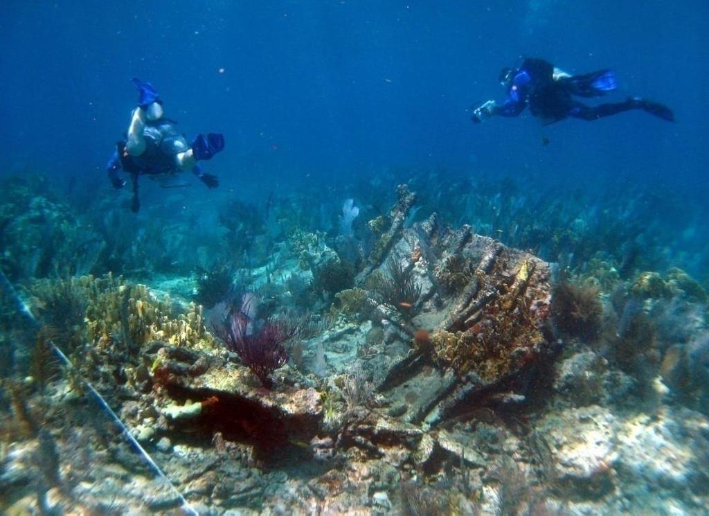
12 Over the years we ve constructed several photomosaics of parts of the wreck. This image is of the south end showing the truncated end of the keel assembly, which is indicated by the arrow and has been used by divers for orientation. Various disarticulated debris lies to the south, in the bottom part of the image.

13 On the morning of September 10, 2017, Hurricane Irma struck the Lower Florida Keys as a Category 4 storm with sustained winds of 130 mph, causing widespread destruction throughout the island chain.


14 FKNMS reported extensive damage to both natural and cultural sites in the Upper Keys, including Pickles Reef. The Sanctuary asked MAHS to resurvey the Barrel Wreck to assess its condition following the storm. These photos were taken by the Sanctuary during the winter after the storm.
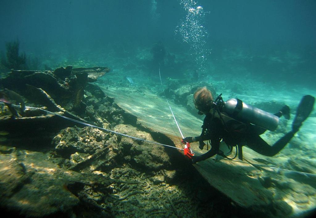
15 To re-survey the site we used a combination of mapping and photography. The mapping technique MAHS uses is baseline trilateration. It is a simple method, easy to understand and execute. baseline baseline Two measurements are made from points along a baseline to each feature we want to include in our site map. The measurements can then be reproduced on a map at any scale.

16 We begin the field school training with a dry-land walkthrough of the trilateration procedure. It s a chance to practice before going into the water to be sure we all understand the process.


17 We supplemented the mapping with a photogrammetric study of the site conducted by Matt Thompson. Photogrammetry is rapidly becoming an important method of site documentation in archaeology. It can be a fast and accurate process, and so it is particularly useful in underwater investigations due to the time constraints imposed by diving. Control points, like the marker in the inset, are placed around the site to assist in combining photos taken from various angles.

18 Each marker has a unique design that computer software can recognize and use to help in accurately overlapping a series of photos.

19 OK, enough preliminaries. Off we go.


20 After setting a baseline, the first order of business was to plot the locations of the control points.


21 This task provided plenty of practice at trilateration mapping.

22 Plenty of practice...

23 By recording the GPS coordinates of the control points we can place the site in a real-world coordinate system. Because the site is in shallow water we could, as in previous work at the site, record GPS data by floating a hand-held unit on the surface connected to a down-line placed over each point by a diver.

24 We also re-measured and re-drew some of the large features that were separate from the metal wreck. Here divers are working on a section of deck framing.

25 Between dives there s discussion of conditions and findings, allowing us to refine plans for the next round of dives.
26 While much of the site appeared to be intact after the storm, there were some substantial changes noted. For example, this very large section of hull plating was found off the end of the keel. The feature was not in that location previously, and we re not sure at this point where it came from.

27 The broken end of the keel assembly, noted earlier as an orientation point, is shown by the arrow below the diver.


28 Here are some before and after images of the same area, with arrows again indicating the end of keel. Above is a pre-irma view showing miscellaneous metal features. The image to the right is a post-irma view showing the area from a slightly different angle. Many of the features appear to have moved or to have been covered by the large section of hull plating.


29 The end of the keel assembly itself had been damaged somewhat. In the pre-irma image on the left, the feature looked like a single metal beam. Some of the frames are visible perpendicular to the beam in the foreground and background. The post-irma image on the right shows the keel to have a laminated structure and to be separating longitudinally along the joins, presumably after being exposed and battered during the storm. The frames are still visible, although some of the rubble in the foreground has been scoured away.


30 pre-irma post-irma Large features west of the metal wreck, such as this bulkhead, showed little change.


31 pre-irma post-irma This section of deck framing also showed little change. Some of the smaller rubble had been rearranged, but the feature itself appeared largely unaffected.
32 The photomosaics in the following slide show before and after images of barrels and metal fragments just south and west of the wreck. The location of the transects is approximated by the blue oval.


33 pre-storm The same area after the hurricane. A few barrel casts remain in place while others, along with loose metal debris, have been moved by the effects of the storm.

34 The effects on the natural environment were varied. In the image on the right, a section of hull plating plate lay face down near a coral formation prior to the storm. On the left, a post-storm image shows the hull fragment turned over and an additional smaller plate present nearby, but with little apparent effect to the adjacent coral.


35 Some of the gorgonians on the site were very sturdy. These images show a mast step and hull section at the north end of the wreck. The pre-irma image on the left shows some large and distinctive gorgonians, one on the keel assembly near the mast step, and one attached to a stringer on the hull section in the background. The image on the right is post-irma and shows the gorgonians still in place.


36 After gathering trilateration data at the site comes the all-important step of plotting the points. Here s where the divers see their work take shape on a map and can check their results for points that may look incorrect and thus would need to be checked on subsequent dives.


37 These are 3-D images of the mast step and hull fragment at the north end of the wreck, some of the results of the photogrammetry work.

38 In the end were able to document some substantial changes to the site, although portions of the metal wreck appeared relatively unaffected by the storm. All in all, great work by a great team of divers.


39 The organizations involved in the project this season included: The organizations involved in the project this season included: MAHS Maritime Archaeological and Historical Society, Washington, D.C. NOAA / Florida Keys National Marine Sanctuary Florida Bureau of Archaeological Research And special thanks again to Brenda Altmeier and Matthew Lawrence of the Florida Keys National Marine Sancturay for their continued support of the MAHS educational programs. Dave Shaw, Jim Smailes, Brenda Altmeier, William Blodgett and Dennis Knepper contributed photos for this presentation.
MAHS Survey of Unidentified Shipwreck Remains on Pickles Reef within the Florida Keys National Marine Sanctuary
 MAHS Survey of Unidentified Shipwreck Remains on Pickles Reef within the Florida Keys National Marine Sanctuary Conducted under Permit FKNMS -2009-054-A1 Key Largo and the FKNMS MAHS was issued a revised
UNDERWATER ARCHAEOLOGY Pickles Reef Florida Keys National Marine Sanctuary
 UNDERWATER ARCHAEOLOGY Pickles Reef Florida Keys National Marine Sanctuary MAHS Survey and Field School 2011 MAHS returned to Florida in June of 2011 to continue a survey of Pickles Reef begun in 2010.
FLAGLER BEACH PIER POST INCIDENT SAFETY INSPECTION HURRICANE IRMA SEPTEMBER 15-17, 2017
 LOGAN DIVING & SALVAGE 2815 SAINT JOHNS BLUFF JACKSONVILLE, FLORIDA 32246 TEL: (904) 731-0000 FAX: (904) 731-5493 MARINE SPECIALTY CONTRACTOR FL SCC131151014 FLAGLER BEACH PIER POST INCIDENT SAFETY INSPECTION
Nautical Chart Challenge
 Discover Your World With NOAA Nautical Chart Challenge For as long as anyone in his family could remember, Francis Beaufort wanted to make scientific observations from the deck of a ship. In 1789 at the
VIDEO TRANSCRIPT. A Proposal to Expand the Flower Garden Banks National Marine Sanctuary An interview with Sanctuary Superintendent, G.P.
 VIDEO TRANSCRIPT A Proposal to Expand the Flower Garden Banks National Marine Sanctuary An interview with Sanctuary Superintendent, G.P. Schmahl (Opening scene of Flower Garden Banks National Marine Sanctuary
A Remote-sensing Survey of Key West Harbor and Approaches,
 A Remote-sensing Survey of Key West Harbor and Approaches, 2003-2004 Magnetometers Ready to be Deployed, Key West Harbor, December, 2003 Prepared by: Corey Malcom Mel Fisher Maritime Heritage Society 200
NEED FOR SUPPLEMENTAL BATHYMETRIC SURVEY DATA COLLECTION
 305 West Grand Avenue, Suite 300 Montvale, New Jersey 07645 Phone 201.930.9890 Fax 201.930.9805 www.anchorqea.com M EMORANDUM To: Caroline Kwan and Nica Klaber U.S. Environmental Protection Agency Region
EXPEDITION ADVENTURE PART 2: HIGHER RESOLUTION RANGE SEISMIC IMAGING TO LOCATE A SUNKEN PIRATE SHIP OFF ILE ST MARIE.
 EXPEDITION ADVENTURE PART 2: HIGHER RESOLUTION RANGE SEISMIC IMAGING TO LOCATE A SUNKEN PIRATE SHIP OFF ILE ST MARIE. Jakob B.U. Haldorsen, and Douglas E. Miller, Schlumberger-Doll Research, Ridgefield,
PARTS OF A SHIP. Fore and Aft Rigged Schooner. Square-Rigged Brig. Side-Wheel Steamer. Steam Propeller. Bulk Freighter. Great Lakes Schooner
 PARTS OF A SHIP Pilothouse Porthole Life Boat Steam Propeller STERN Ship s Wheel Cornelia B. Windiate Great Lakes Schooner Site Plan Yawl Boat Mizzen Mast Smoke Stack Bulk Freighter Propeller Deck Planks
Improving fishermen awareness to reduce the presence of lobster traps in MPAs of the Florida Keys. Gabrielle Renchen & Tom Matthews
 Improving fishermen awareness to reduce the presence of lobster traps in MPAs of the Florida Keys Spiny Lobster Advisory Panel Meeting Key Largo, FL April 25, 2016 Gabrielle Renchen & Tom Matthews Florida
Telemark 2012: In Search of Dalen s Submerged History
 Telemark 2012: In Search of Dalen s Submerged History Dalen Dalen is a small town at the start of the Telemark waterway. The population is approximately 800. We worked here Planning For hundreds of years,
VIII. Marine Debris. Background
 VIII. Marine Debris Background Fishing constitutes one of the most significant threats to marine biodiversity and ecosystem function, as evidenced by a significant body of information on the numerous impacts
State of the Art Mapping of Portland Harbour - August 2004
 State of the Art Mapping of Portland Harbour - August 2004 In 2003 and 2004, as part of the "Diving with a Purpose" initiative the Nautical Archaeology Society mapped some of the wrecks in and around Portland
REPORT OF INITIAL SURVEY OF AN UNKNOWN BARGE OFF OF CEDAR POINT, SANDUSKY, OHIO. July 26-27, Submitted to Cleveland Underwater Explorers, Inc.
 REPORT OF INITIAL SURVEY OF AN UNKNOWN BARGE OFF OF CEDAR POINT, SANDUSKY, OHIO July 26-27, 2008 Submitted to Cleveland Underwater Explorers, Inc. By Jack Papes SUBJECT Report of Initial survey of an unknown
SHIP FORM DEFINITION The Shape of a Ship
 SHIP FORM DEFINITION The Shape of a Ship The Traditional Way to Represent the Hull Form A ship's hull is a very complicated three dimensional shape. With few exceptions an equation cannot be written that
Vieques Underwater Demonstration Project
 Vieques Underwater Demonstration Project NOAA Office of Response and Restoration National Ocean Service 2006-2007 2007 University of New Hampshire Joint Hydrographic Center 2006 Science Application International
Boat Strength Errata & Updates 5/7/18 Sheet 1 of 5
 Boat Strength Errata & Updates 5/7/18 Sheet 1 of 5 Formulas 1-2 and 1-3, page 7: Instead of averaging LOA and LWL and when LOA is more than 108% and instead of averaging BOA and BWL when BOA is over 112%,
Preliminary design of a high-altitude kite. A flexible membrane kite section at various wind speeds
 Preliminary design of a high-altitude kite A flexible membrane kite section at various wind speeds This is the third paper in a series that began with one titled A flexible membrane kite section at high
Volunteer and Internships Programs ECUADOR
 Volunteer and Internships Programs ECUADOR Equilibrio Azul is a non-for profit organization created in 2005 to protect the marine resources of Ecuador. Our mission is to integrate local communities, governmental
RESOLUTION MSC.235(82) (adopted on 1 December 2006) ADOPTION OF THE GUIDELINES FOR THE DESIGN AND CONSTRUCTION OF OFFSHORE SUPPLY VESSELS, 2006
 (adopted on 1 December 2006) ADOPTION OF THE GUIDELINES FOR THE DESIGN AND CONSTRUCTION OF OFFSHORE SUPPLY VESSELS, 2006") MSC 82/24/Add.2 RESOLUTION MSC.235(82) CONSTRUCTION OF OFFSHORE SUPPLY VESSELS, 2006 THE MARITIME SAFETY COMMITTEE, RECALLING Article 28(b) of the Convention on the International Maritime Organization
MSC 82/24/Add.2 RESOLUTION MSC.235(82) CONSTRUCTION OF OFFSHORE SUPPLY VESSELS, 2006 THE MARITIME SAFETY COMMITTEE, RECALLING Article 28(b) of the Convention on the International Maritime Organization
14/10/2013' Bathymetric Survey. egm502 seafloor mapping
 egm502 seafloor mapping lecture 10 single-beam echo-sounders Bathymetric Survey Bathymetry is the measurement of water depths - bathymetry is the underwater equivalent of terrestrial topography. A transect
6. SS RICHARD MONTGOMERY 6.1 INTRODUCTION The purpose of this chapter is to describe the assessment of the extent to which the construction and
 6. SS RICHARD MONTGOMERY 6.1 INTRODUCTION The purpose of this chapter is to describe assessment of extent to which construction operation of a new hub airport in inner Thames Estuary could impact upon
Spatial Methods for Road Course Measurement
 Page 1 of 10 CurtinSearch Curtin Site Index Contact Details Links LASCAN Spatial Sciences WA Centre for Geodesy COURSE MEASUREMENT This page is a summary of results of some of the research we have recently
MVF Sanu Mitigation Survey and Timber Recovery
 1 MVF Sanu Mitigation Survey and Timber Recovery 2 MVF Sanu Mitigation Survey and Timber Recovery Acknowledgements MAST would like to thank the Ian Kemp, National Trust General Manager for North Cornwall
Stevenson Projects Building the Hull Top Deck and Bulkheads
 Stevenson Projects Building the Hull 1. Print out both piece sheets. 2. Cut out one keel piece and glue it to a piece of balsa wood or dense cardboard. Cut out the second keel piece and glue it to the
DIVING WITH A PURPOSE XIV Restoring Our Oceans, Preserving Our Heritage. June 3-9, 2018
 Restoring Our Oceans, Preserving Our Heritage PROGRAM CONTACT: KEN STEWART (615) 730-4906 Website : www.divingwithapurpose.org The annual Diving With a Purpose (DWP) maritime archaeology program is scheduled
Geomorphology of grouper and snapper spawning aggregation sites in the Upper Florida Keys, USA
 Geomorphology of grouper and snapper spawning aggregation sites in the Upper Florida Keys, USA Art Gleason, Pamela Reid Division of Marine Geology and Geophysics University of Miami / Rosenstiel School
Marine Construction & Welding Prof. Dr. N. R. Mandal Department of Ocean Engineering & Naval Architecture Indian Institute of Technology, Kharagpur
 Marine Construction & Welding Prof. Dr. N. R. Mandal Department of Ocean Engineering & Naval Architecture Indian Institute of Technology, Kharagpur Lecture No # 10 Fore & Aft End Construction (Refer Slide
Hansa COG 14 th century SCALE: 1/72 Length: 430mm Width: 210mm Height: 330mm
 Hansa COG 14 th century SCALE: 1/72 Length: 430mm Width: 210mm Height: 330mm HISTORY: The Hansa was a medieval association of German cities which engaged by in long distance business mainly in area of
Effective multi-agency collaboration improves spatial monitoring and planning in the Florida Keys
 Effective multi-agency collaboration improves spatial monitoring and planning in the Florida Keys Jim Bohnsack Southeast Fisheries Science Center NOAA Fisheries Service Miami, FL 1 The Managed Florida
Land Navigation at Nevada Youth Range Camp
 Curriculum 15-03 Land Navigation at Nevada Youth Range Camp Stephen S. Foster, Pershing County Extension Educator Sherm Swanson, Riparian and Rangeland Specialist This curriculum is used at Nevada Youth
The Wreck of the Albatross
 The Wreck of the Albatross Photo by Chris Doyal Compiled by: Chris Doyal Greg MacMaster Devin O Meara NAS II Survey Project Sketch by Greg MacMaster Submitted November, 2009 Table of Contents: History
TP 11249E SHIP SAFETY STANDARD FOR IN-WATER SURVEYS
 TP 11249E SHIP SAFETY STANDARD FOR IN-WATER SURVEYS Canadian Coast Guard Ship Safety Branch 1992 TP 11249E RECORD OF CHANGES STANDARD FOR IN WATER SURVEYS DATE OF AMENDMENT AMENDMENT NUMBER SECTION AMENDED
Ecological Processes and Coral Reef Recovery in the Florida Keys
 Final 2 October 26 Ecological Processes and Coral Reef Recovery in the Florida Keys Struan R. Smith (Bermuda Biological Station for Research, Inc., St. George s GE, Bermuda) Richard B. Aronson and Thaddeus
HMS Colossus Dive Trail
 HMS Colossus Dive Trail HMS Colossus Dive Trail Read this page before the dive HMS Colossus was a 74 gun warship built in 1787 at Gravesend and wrecked in 1798. These 74 gun ships were one of the most
Biogeographic Assessment of Florida Keys National Marine Sanctuary
 Biogeographic Assessment of Florida Keys National Marine Sanctuary NOAA National Centers for Coastal Ocean Science NOAA Florida Keys National Marine Sanctuary Florida Fish and Wildlife Commission Photos
Curacao Reef Acoustics Expedition Ed Sobey, PhD.
 Flag report Background Climate change and environmental pressure are having drastic impact on coral reefs worldwide. Thermal and ph stress combine with infections to kill this, the most diverse and productive
CLUE, New Wreck Dive Report
 Cleveland Underwater Explorers (CLUE) is proud to announce the existence of yet another new wreck in Lake Erie off the Cleveland area. This report describes the wreck for the first time, and a tentative
An Example of Adaptive Ship Construction: Examining the Vinta in Its Geographic Context
 Jacob Bradt Anthro1218 Museum Project: Pt. III An Example of Adaptive Ship Construction: Examining the Vinta in Its Geographic Context To analyze the construction of the Peabody Museum s model of a vinta,
4 wild winds AND white water
 94 PoSTcArDS from THe edge 4 wild winds AND white water Above: Being regarded as the most famous lighthouse in the world has meant that eddystone featured extensively on early postcards and you ll see
Assessment of Artificial Reefs Impacted by Hurricane Michael
 Assessment of Artificial Reefs Impacted by Hurricane Michael Jeff Renchen, Keith Mille, Devin Resko, Christine Kittle Florida Fish and Wildlife Conservation Commission Division of Marine Fisheries Management
S0300-A6-MAN-010 CHAPTER 2 STABILITY
 CHAPTER 2 STABILITY 2-1 INTRODUCTION This chapter discusses the stability of intact ships and how basic stability calculations are made. Definitions of the state of equilibrium and the quality of stability
MSC Guidelines for Review of Rigging Systems for Sailing Vessels
 S. E. HEMANN, CDR, Chief, Hull Division Table of Contents References... 1 Contact Information... 2 Applicability... 2 General Guidance... 2 Methodology... 3 Stability and Rigging System... 3 Hull Structure
Horizontal Fuselage. Top Vertical Fuselage 1. Lay out the Top Vertical Fuse Front(1), Top Vertical Fuse Back(2), and Vertical Stabilizer(3).
, Top Vertical Fuse Back(2), and Vertical Stabilizer(3).") Rumbuilder 71 B-17 Congrats on your Rumbuilder B-17! We re glad you chose to fly with us! If you have any problems, or missing/broken kit pieces, please contact us. We d be happy to replace any damaged
Rumbuilder 71 B-17 Congrats on your Rumbuilder B-17! We re glad you chose to fly with us! If you have any problems, or missing/broken kit pieces, please contact us. We d be happy to replace any damaged
An Assessment of Quality in Underwater Archaeological Surveys Using Tape Measurements
 An Assessment of Quality in Underwater Archaeological Surveys Using Tape Measurements Peter Holt 3H Consulting Ltd, 6 Honcray, Oreston, Plymouth, Devon, PL9 9XB The quality of a typical underwater archaeological
Weedy Seadragon Ecology Project. Annual Report Underwater Research Group of NSW Fish Ecology Lab, UTS
 Weedy Seadragon Ecology Project Annual Report 2015 Underwater Research Group of NSW Fish Ecology Lab, UTS 1. Summary UTS and URG forged an informal partnership in 2015, to further the seadragon research
Bonaire National Marine Park Hurricane Matthew Reef Damage Assessment
 Bonaire National Marine Park Hurricane Matthew Reef Damage Assessment Hurricane Matthew passed north of Bonaire on September 23 rd, 2016. After it passed Aruba, it decelerated, and then it slowly began
Measurement of court speed and bounce. Rod Cross, Physics Department, Sydney University 2nd July 2006
 1 Measurement of court speed and bounce Rod Cross, Physics Department, Sydney University 2nd July 2006 The speed of a surface refers to the change in ball speed in a direction parallel to the surface.
Wade Reynolds 1 Frank Young 1,2 Peter Gibbings 1,2. University of Southern Queensland Toowoomba 4350 AUSTRALIA
 A Comparison of Methods for Mapping Golf Greens Wade Reynolds 1 Frank Young 1,2 Peter Gibbings 1,2 1 Faculty of Engineering and Surveying 2 Australian Centre for Sustainable Catchments University of Southern
Unit 1 Lesson 2: Reef Surveys and Deep Worker. When Coral Reefs Get in the Way...
 Unit 1 Lesson 2: Reef Surveys and Deep Worker Lesson Objectives: Upon completion of this unit students should gain knowledge and understanding of: factors that cause physical damage to coral reefs the
Survey Technique for Underwater Digital Photography with Integrated GPS Location Data
 Survey Technique for Underwater Digital Photography with Integrated GPS Location Data Tim Siwiec: United States Environmental Protection Agency Abstract This survey technique is an inexpensive method of
Underwater excavation of a shipwreck. Bougianen Project (Menorca, Spain)
") Course 049 Underwater excavation of a shipwreck. Bougianen Project (Menorca, Spain) 1. General Information The Sanisera Archaeology Institute for International Field Schools offers annual programs in archaeology.
Course 049 Underwater excavation of a shipwreck. Bougianen Project (Menorca, Spain) 1. General Information The Sanisera Archaeology Institute for International Field Schools offers annual programs in archaeology.
Wrecking barge Petrus
 The Purton Hulks Phase 1 Report No 14 Wrecking barge Petrus The Friends of Purton Compiled 1 st March 2010 - 2 - Contents 1.1 Vessel identification page 5 1.2 Photographic comparison page 6 1.2.1 Historic
Surveying & Measurement. Distance Measurement
 Surveying & Measurement Distance Measurement Introduction One of the most fundamental surveying operations is the measurement of horizontal distance between two points on the surface of the earth. There
Scientists create 360-degree images of Hawaii coral reefs 19 August 2015, bycaleb Jones
 Scientists create 360-degree images of Hawaii coral reefs 19 August 2015, bycaleb Jones 360-degree underwater camera to photograph coral reefs in Kaneohe Bay off the east coast of Oahu, Hawaii. coral reefs
Investigation of the Impact of Beach Raking on Beach Accretion/Erosion: West End Beaches of Galveston Island, Texas 2007/ 2008
 Investigation of the Impact of Beach Raking on Beach Accretion/Erosion: West End Beaches of Galveston Island, Texas 2007/ 2008 By Robert Webster 1, Timothy Dellepenna Ph.D. 1, 1 Texas A&M at Galveston
NOAA/NSTA Web Seminar: Coral Ecosystems: Impacts to Coral Reefs
 LIVE INTERACTIVE LEARNING @ YOUR DESKTOP NOAA/NSTA Web Seminar: Coral Ecosystems: Impacts to Coral Reefs Thursday, April 10, 2008 1 Impacts to Coral Reefs Presented by: Kelly Drinnen, Education Specialist
Field Protocol for Monitoring Coral Reef Fisheries Resources in Belize
 Field Protocol for Monitoring Coral Reef Fisheries Resources in Belize Charles A. Acosta, PhD Wildlife Conservation Society Glover s Reef Marine Research Station P.O. Box 272 Dangriga, Belize and Department
Artificial Reef Uses. Mitigation Shore Protection Scientific Studies Habitat Creation Conservation Economic Stimulus Diver Attractions
 Artificial Reef Uses Mitigation Shore Protection Scientific Studies Habitat Creation Conservation Economic Stimulus Diver Attractions Barbados Study The Relationship between Diver Experience Levels and
High Definition Laser Scanning (HDS) Underwater Acoustic Imaging and Profiling
 Underwater Acoustic Imaging and Profiling") High Definition Laser Scanning (HDS) Underwater Acoustic Imaging and Profiling Images at Depth: The Use of Acoustic Imaging on Large River Crossings A Case Study AGENDA Background of project Review of
High Definition Laser Scanning (HDS) Underwater Acoustic Imaging and Profiling Images at Depth: The Use of Acoustic Imaging on Large River Crossings A Case Study AGENDA Background of project Review of
RULES PUBLICATION NO. 20/P SHIP SIDE STRENGTHENING OF FISHING VESSELS MOORING AT SEA ALONGSIDE OTHER VESSELS
 RULES PUBLICATION NO. 20/P SHIP SIDE STRENGTHENING OF FISHING VESSELS MOORING AT SEA ALONGSIDE OTHER VESSELS 1995 Publications P (Additional Rule Requirements), issued by Polski Rejestr Statków, complete
Utilizing Vessel Based Mobile LiDAR & Bathymetry Survey Techniques for Survey of Four Southern California Breakwaters
 Utilizing Vessel Based Mobile LiDAR & Bathymetry Survey Techniques for Survey of Four Southern California Breakwaters Western Dredging Association: Pacific Chapter September 2012 Insert: Pipe Location
Recovery of Coral Populations at Helen Reef Atoll after a Major Bleaching Event
 Recovery of Coral Populations at Helen Reef Atoll after a Major Bleaching Event Yimnang Golbuu 1, Jay Andrew 1, Geory Mereb 1, Robert van Woesik 2 1 Palau International Coral Reef Center 2 Florida Institute
MISSION PLANNING AND DATA ACQUISITION SOFTWARE
 MISSION PLANNING AND DATA ACQUISITION SOFTWARE INTENTIONALLY BLANK Introduction to Divelog Shark Marine s Divelog software was created to integrate data collected from an array of sensors, real-time with
Plot the Path. Mary Anne Otten. lesson three
 Plot the Path Mary Anne Otten lesson three Subject/Grade: Grade 2, Math, Social Studies, Science Duration: one class period Materials needed: Per class: Day the Great Lakes Drained Away by Charles Ferguson
Determining coral reef impacts associated with boat anchoring and user activity
 Determining coral reef impacts associated with boat anchoring and user activity Protect Our Reefs Grant Interim Report October 1, 2008 March 31, 2009 Donald C. Behringer 1, Thomas K. Frazer 1, Robert A.
Building Planning PART. Chapter 3. Chapter 3. Building Planning. Climatic and Geographic Design Criteria C
 PART 2 Building Planning Chapter 3 Chapter 3 Building Planning TA B L E R 3 0 1. 2 ( 1 ) Climatic and Geographic Design Criteria C hapter 3 includes the bulk of the nonstructural provisions, including
Bioerosion Monitoring Unit (BMU) SOP
 SOP") Bioerosion Monitoring Unit (BMU) SOP I. Purpose II. Construction and predeployment analysis a. Materials b. Assembly procedure III. Deployment directions a. Materials b. Dive preparation c. Dive operation
Bioerosion Monitoring Unit (BMU) SOP I. Purpose II. Construction and predeployment analysis a. Materials b. Assembly procedure III. Deployment directions a. Materials b. Dive preparation c. Dive operation
Anatomy of a Depth Survey
 1 Anatomy of a Depth Survey Part I General Considerations Tom O Donnell, AP Miles River Squadron 2 Why do depth surveys? NOAA, through its Office of Coast Survey, is mandated to keep our nautical charts
Teaching students about how technology enables science through building Aquarius Habitats.
 Lesson Plan Aquarius Technology: Building an Underwater Habitat Focus Teaching students about how technology enables science through building Aquarius Habitats. Focus Questions Why build an underwater
THE APPLICATION OF THE FUSION POSITIONING SYSTEM TO MARINE ARCHAEOLOGY
 THE APPLICATION OF THE FUSION POSITIONING SYSTEM TO MARINE ARCHAEOLOGY PETER HOLT Sonardyne International Ltd, Blackbushe Business Park, Yateley, Hants, UK E-mail: pete@threeh.demon.co.uk The Sonardyne
Between East and West The Phoenician Shipwreck off Gozo
 Between East and West The Phoenician Shipwreck off Gozo Season Report Dr Timmy Gambin Department of Classics & Archaeology University of Malta October 2017 Preamble Research on the Phoenician shipwreck
UNDERSTANDING STORM SURGE
 The Education Program at the New Jersey Sea Grant Consortium 22 Magruder Road, Fort Hancock, NJ 07732 (732) 872-1300 www.njseagrant.org UNDERSTANDING STORM SURGE ACTIVITY 6 SURGE OF THE STORM http://secoora.org/classroom/virtual_hurricane/surge_of_the_storm>
Data Collection and Processing: Elwha Estuary Survey, February 2013
 Data Collection and Processing: Elwha Estuary Survey, February 2013 Ian Miller, WA Sea Grant Olympic Peninsula Field Office, 1502 E. Lauridsen Blvd #82, Port Angeles, WA 98362 immiller@u.washington.edu
Navigation & Orienteering: Pre- Test
 Name: Class: Answer Key Date: Page 1 of 7 Navigation & Orienteering: Pre- Test There are three sections: Multiple Choice, True/False, and Short Answer. For the multiple choice, please select the BEST answer
DIVE 1: UNDERWATER EXPLORER
 DIVE 1: UNDERWATER EXPLORER Summary This lesson introduces students to the marine habitat and the wealth and diversity of life found in the ocean. Students will learn about how scientists explore underwater,
NOT TO SCALE PUBLIC WORKS STANDARD DETAILS CURB DETAILS DATE: MARCH 2013 FILE NAME: CURB.DWG
 NOT TO SCALE PUBLIC WORKS STANDARD DETAILS CURB DETAILS DATE: MARCH 2013 FILE NAME: CURB.DWG NOT TO SCALE PUBLIC WORKS STANDARD DETAILS SIDEWALK RAMPS DATE: MARCH 2013 FILE NAME: SIDEWALK RAMPS.DWG NOT
Experimental reestablishment of populations of the long spined sea urchin, Diadema antillarum, on two small patch reefs in the upper Florida Keys
 Principal Investigator Ken Nedimyer 212 Silver Palm Avenue Tavernier, FL 33070 phone (305) 852-4955, fax (305) 852-3500 email, sealife@terranova.net Associate Investigator Martin A. Moe, Jr. 222 Gulfview
CARLETON ISLAND UNDERWATER ARCHAEOLOGY PROJECT SUGGESTED APPROACH
 CARLETON ISLAND UNDERWATER ARCHAEOLOGY PROJECT SUGGESTED APPROACH - 1 - CARLETON ISLAND UNDERWATER ARCHAEOLOGY PROJECT SUGGESTED APPROACH SITE: Sunken remains of a wooden sailing vessel, probably late
How using Trackman can help coaches produce better results
 WWW.TRACKMANROADSHOW.COM How using Trackman can help coaches produce better results The purpose of this case study is to prove that using Trackman can help coaches produce better results with their students
Final Cruise Report Marine Mammal Observer UNDET Monitoring Hawaii Range Complex, April, 2011
 213 APPENDIX I. Cruise Report, Marine Mammal Observer UNDET Monitoring Hawaii Range Complex, August 12, 2011 Final Cruise Report Marine Mammal Observer UNDET Monitoring Hawaii Range Complex, 26-27 April,
DAMAGE STABILITY TESTS OF MODELS REPRESENTING RO-RC) FERRIES PERFORMED AT DMI
 FERRIES PERFORMED AT DMI") TECHNISCHE UNIVERSITET laboratoriurn vow Scheepshydromechareba slechlef Meketweg 2, 2628 CD. Delft Tel.: 015-788873 - Fax 015-781838 DAMAGE STABILITY TESTS OF MODELS REPRESENTING RO-RC) FERRIES PERFORMED
TECHNISCHE UNIVERSITET laboratoriurn vow Scheepshydromechareba slechlef Meketweg 2, 2628 CD. Delft Tel.: 015-788873 - Fax 015-781838 DAMAGE STABILITY TESTS OF MODELS REPRESENTING RO-RC) FERRIES PERFORMED
NOAA s Underwater UXO Demonstration Projects Vieques Island, Puerto Rico
 NOAA s Underwater UXO Demonstration Projects Vieques Island, Puerto Rico Vieques Restoration Advisory Board Meeting May 7, 2008 Jason Rolfe NOAA s Office of Response & Restoration NOAA s Underwater UXO
Ghost (net) Busters. Ghost Net Retrieval. Time to complete lesson: minutes
 Busters. Ghost Net Retrieval. Time to complete lesson: minutes") Ghost (net) Busters Ghost Net Retrieval Time to complete lesson: 20-30 minutes Purpose of module: This module allows students to simulate the removal of a derelict fishing net from a model coral reef.
Ghost (net) Busters Ghost Net Retrieval Time to complete lesson: 20-30 minutes Purpose of module: This module allows students to simulate the removal of a derelict fishing net from a model coral reef.
University of North Carolina at Chapel Hill Phone: (252) , ext. 380 Department of Biology Fax: (252)
 , ext. 380 Department of Biology Fax: (252)") AVERY BYRD PAXTON University of North Carolina at Chapel Hill Phone: (252) 726-6841, ext. 380 Department of Biology Fax: (252) 726-2426 Institute of Marine Sciences Website: http://www.averypaxton.org
AVERY BYRD PAXTON University of North Carolina at Chapel Hill Phone: (252) 726-6841, ext. 380 Department of Biology Fax: (252) 726-2426 Institute of Marine Sciences Website: http://www.averypaxton.org
Eelgrass and Macroalgae Presence/Absence Preliminary Surveys BHP Proposed Grays Harbor Potash Export Facility A Task 400
 Memorandum 40600-HS-MEM-55036 Revision 0 Date: 26 July 2018 Subject: Eelgrass and Macroalgae Presence/Absence Preliminary Surveys BHP Proposed Grays Harbor Potash Export Facility A17.0202.00 Task 400 INTRODUCTION
NOBLE REV 02 FPSO MOORING SYSTEM INTEGRITY STUDY
 DENTON INTEGRITY STUDY APPENDIX C INCIDENT REPORTS Incident One FPSO Questionnaire Failure of gripper used to rotate turret Several months after installation This FPSO has an internal partially rotating
Beach Profiles: Monitoring Sea Level Rise. Student Activity Sheet. Name Date Class
 Beach Profiles: Monitoring Sea Level Rise Student Activity Sheet Name Date Class A shoreline is the area where the water and land meet. This is where we find beach: areas where sediments (sand or other
Turks Head Walking Stick Part 3: Knot Construction Third and Final Pass
 Turks Head Walking Stick Part 3: Knot Construction Third and Final Pass Paul Young-Davies Matthew Young-Davies 1 st Stittsville scouts D R A F T KNOT TERMINOLOGY It is important to understand some of the
Astrolabe Reef Access Plan Stakeholder Presentation
 Astrolabe Reef Access Plan Stakeholder Presentation *Rena s bow thruster approx 18m Agenda Overview Access Plan Introduction State of the Reef & Wreck Site What to Expect Timetable & Activity Questions
Cleopatra British Obelisk Transport Barge. Kartonbau.de Exclusive Edition
 Cleopatra 188 British Obelisk Transport Barge Kartonbau.de Exclusive Edition Copyright 2006 Oliver Weiss / The Walden Font Co. P. O. Box 81, Winchester, MA 01890 www.waldenfont.com Historical Notes The
Stourport motor barge Severn Collier
 The Purton Hulks Phase 1 Report No 21 Stourport motor barge Severn Collier The Friends of Purton Compiled 1 st March 2010 - 2 - Contents 1.1 Vessel identification page 5 1.2 Photographic comparison page
With a team of highly qualified divers Vision offers a wide range of services including;
 Commercial Diving Services With a team of highly qualified divers Vision offers a wide range of services including; Civils Diving Services Inspections, Construction and maintenance on bridges, piles, quay
KNARR. SCALE: 1/35 length: 440mm width: 300mm height: 400mm
 KNARR SCALE: 1/35 length: 440mm width: 300mm height: 400mm HISTORY: The Knarr is a type of Viking ship which serves for long trade naval business. The Knarrs were very robust and very well resist against
TRAFFIC CONTROLS FOR BICYCLE FACILITIES
 PART IX. TRAFFIC CONTROLS FOR BICYCLE FACILITIES A. GENERAL 9A-1 Requirements for Bicyclist Traffic Control Devices Traffic control devices, whether they are intended for motorists or bicyclists, must
Lee E. Harris, Ph.D., P.E. Assoc. Professor of Ocean Engineering. Doug Bowlus and Ashley Naimaster Ocean Engineering Graduate Students
 FLORIDA TECH OCEAN ENGINEERING PROFESSOR LEE HARRIS AND HIS GRADUATE STUDENTS ASSIST WITH POST-HURRICANE IVAN CORAL REEF RESTORATION IN THE CAYMAN ISLANDS Lee E. Harris, Ph.D., P.E. Assoc. Professor of
Mooring, rafting, springing, locks etc, etc
 Mooring, rafting, springing, locks etc, etc www.skysailtraining.co.uk Mooring Alongside a pontoon 1. Adequate fenders 2. Springs are as important as shore lines they stop the boat moving fore and aft.
ITRC Environmental Management at Operating Outdoor Small Arms Firing Ranges February Shotgun Ranges
 2.2.2 Shotgun Ranges In contrast to rifle/pistol ranges, shot at shotgun ranges (trap, skeet, and sporting clays) is widely distributed. When a shotgun target is hit by a well-centered shot, only a relatively
COASTAL EROSION. 1 Getting Oriented
 COASTAL EROSION Many people dream of building their home on the California Coastline with its picturesque vistas of the setting sun and the gentle sounds of waves breaking. However, these waves are not
Perth Schooner Sarah MacDonad
 The Purton Hulks Phase 1 Report No 33 Perth Schooner Sarah MacDonad The Friends of Purton Compiled 1 st March 2010 - 2 - Contents 1.1 Vessel identification page 5 1.2 Photographic comparison page 6 1.2.1