CHAPTER 8 BUOYAGE 8.1 GENERAL
|
|
|
- Curtis Turner
- 6 years ago
- Views:
Transcription
1 145 CHAPTER 8 BUOYAGE 8.1 GENERAL The term `buoyage encompasses all floating structure such as buoys or beacons which are used to orientate mariners and to mark the edges of navigable channels and fairways. Structures in this group are also used to mark hazards to navigation such as, shoals, banks, rocks, wrecks, and danger zones. (Lightvessels, as far as they still exist, form a separate category by themselves.) They generally serve as guides during daylight. When fitted with a light, they are also available for navigation at night. Those having a sound signal also indicate their position in fog or other conditions of low visibility. Buoys and beacons are also referred to as `buoyage marks or simply `marks, and are distinguished from one another by their shape, colour, topmark, number, characteristics of light and/or sound signal. In coastal waters and harbours buoyage is also used for the following special purposes: a. Indicating limits of fishing grounds where submerged nets may be encountered: fish trap buoys. b. Indicating moorings for vessels: barrel buoys, tun buoys, or mooring buoys. c. Carrying oceanographic or meteorological sensors: ODAS (Ocean Data- Acquisition System) buoys. d. Indicating telegraph or telephone-cables or pipelines: telegraph-cable buoys. e. Indicating the limits of anchorage areas: anchorage buoys. f. Indicating quarantine areas: quarantine buoys. g. Verifying the position of light-vessels: watch buoys or station buoys. 8.2 CONSTRUCTION OF BUOYS There are many different kinds of buoys. Most buoys are painted a conspicuous colour and consist of the following components (Figure 8.1): a. a body or float with anchoring or mooring device; b. a superstructure (cage-work or pillar); c. a lantern; d. a topmark (various shapes); e. a radar reflector; f. a sound device (bell, gong, whistle, or horn); g. a conspicuous colour.
2 Buoys equipped with a light are called lighted buoys. When they have no light they are called unlighted buoys or ordinary buoys. Buoys having a sound device only are called sound buoys. Buoys may be classified by their shape as follows: Beacons. Spar buoys. Ordinary buoys. General purpose buoys also called standard buoys. Short pillar buoys. High pillar buoys, also called high focal plane buoys. Beacons, spar buoys and ordinary buoys have no superstructure and are usually unlighted; general purpose and pillar buoys have a superstructure and are usually lighted. General purpose buoys and pillar buoys are usually also equipped with a sound device. 146 Depending on the power used for the lantern, we distinguish propane, acetylene, or electric buoys. (Propane and acetylene are rarely used nowadays.) Buoys bearing lights and sound devices are usually called combination buoys. According to their sound device they may also be called `light and bell buoys, `light and whistle buoys, etc. Figure 8.1 General Purpose Buoy a. Mooring; b:body; c: superstructure (can-shaped) d: lantern; e: topmark; f: radar reflector; g: fog signal (bell) Body of the buoys The body of the buoy is a steel float, varying in size and shape, according to the type of buoy. It is composed of an immersed part and of an emerged part. The submerged part gives the necessary buoyancy. The part above water gives the buoy its particular shape or serves to support its superstructure, lantern, topmark and other devices. The body is always hollow and is used to store gas or batteries for the lantern. Ordinary buoys can be identified both by the shape of their body and their col-
3 our. Lighted buoys, on the other hand, can be identified by their superstructure or topmark Mooring 147 The buoy is anchored to the bottom by a chain and a heavy block of concrete, called sinker (Figures 8.2 f and 8.3 f). When the bottom of a buoy is fitted with two diametrically opposed mooring eyes, the chain is fastened to the buoy by a six metre long `bridle (Figure 8.2 a). When the buoy has only one central mooring eye, an 8 metre long single pendant mooring chain called tail chain (Figure 8.3 a) is used. Figure Mooring with bridle a: bridle; b: triangular link; c: swivel; d: riding chain; e: ground chain; f: sinker. Figure Mooring with single pendant chain a: tail chain; b: triangular link. c: swivel; d: riding chain; e: ground chain; f: sinker. A mooring chain is composed of links, typically made from 35 mm gauge steel. The length of chain is about three times the water depth, depending on the weight of the buoy, depth of water, speed of current, and range of tide. The chain is fitted with a swivel every 20 metres to prevent entanglement (Figures 8.2 c and 8.3 c). Two thirds of the chain rests on the bottom and is called `ground chain (Figures 8.2 e and 8.3 e). The other third which hangs between the buoy and the bottom of the sea is called `riding chain (Figures 8.2 d and 8.3 d). The buoy is thus able to rise and fall with the waves and there is no risk that the sinker will be lifted and moved from its position.
. The weight of a sinker may vary between 1,000 and 5,500 kg.")
. Figure 8.")
4 148 Figure Sinker The sinker is a heavy block of cast iron or concrete. The bottom of the sinker is concave to enable it to be held firmly to the sea-bed by suction (Figure 8.3 f). Concrete sinkers are composed of concrete and scrap iron. The scrap iron serves only to bind the concrete together (Figure 8.4). The weight of a sinker may vary between 1,000 and 5,500 kg., depending upon the weight of the buoy, the sea conditions and the nature of the sea-bed. The anchorage of the sinker is reinforced by a mushroom anchor on sloping or rocky bottoms and on sites where strong currents are running (Figures 8.5 and 8.6). Figure 8.5 Mooring with a mushroom anchor Figure 8.6 Mushroom anchor Superstructure Every buoy should have a well-defined shape. The three main shapes are : conical (Figures 8.7 and 8.8) can (Figures 8.9 and 8.10) spherical (Figure 8.11). NOTES 1. Buoys shown in Figures 8.8, 8.10 and 8.18, are only encountered in American waters. 2. In the U.S., conical buoys are called nun buoys.


1. Figure 8.")


5 149 Other shapes in use are : a. spar (Figure 8.12); b. with superstructure (Figures 8.13 to 8.18 inclusive)1. Figure 8.7 Figure 8.8 Figure 8.9 Figure 8.10 Figure 8.11 Figure 8.12 Figure 8.13 Figure 8.14 Figure 8.16 Figure 8.15 Figure 8.17 Figure 8.18 Conical buoys have the shape of a cone with the pointed end uppermost, and can buoys have the shape of a cylinder. Spar buoys have the shape of a thin vertical pole. ADDITIONAL ILLUSTRATIONS Trinity Harwich Buoy Yard


6 150 Ostend Buoy Yard Ostend Buoy Yard Finland Buoy Types


7 151 Australia ZENI Jets Sinkers at the Ostend Buoy Yard
8 ORDINARY BUOYS Beacons These may be divided into : a. floating beacons; b. fixed beacons; c. stakes; d. tower beacons. Floating beacons have the same appearance as spar buoys and consist of a barely visible float surmounted by a thin, vertical wooden pole (Figures 8.19, 8.20 and 8.21). Fixed beacons are wooden poles which are driven into the sea bottom (Figure 8.22). Stakes are branches which are planted along the edges of a channel. The branches may be loose (Figure 8.23) or tied together like brooms (Figure 8.24). Towers are fixed constructions on the water (Figure 6.5). Figure 8.19 Floating beacon with can Figure 8.20 Floating beacon with can topmark Figure 8.21 floating beacon with radar reflector
9 153 Figure 8.22 Fixed beacon with can topmark Figure 8.23 Stake with loose branches Figure 8.24 Stake with tied branches Floating and fixed beacons are usually painted and rarely carry a number or name. They mostly have a topmark giving to the beacon the shape of the buoy which they replace. Sometimes they are fitted with a radar reflector. Floating beacons are mostly used during the winter as temporary replacements for ordinary buoys, or to mark secondary or shallow channels or fairways. They are mainly encountered in channels and inland waters. Indication of beacons on charts With a few exceptions all beacons are charted in the same way. See symbols and abbreviations used on marine charts, (Plate Q). Fixed beacons are frequently encountered in American waters where they are mostly used as daymarkers. They are shown on charts by a small square or a small triangle pointing upwards, or by a small circle with dot with or without the abbreviation Bn and with the abbreviation of the colour of the beacon. (Figure 2.49). Besides ordinary beacons, mariners may also encounter the following : a. compass adjustment beacons; b. telegraph-cable (landing) beacons; c. cairns; d. painted patches; e. oil installation buoys; f. offshore or drilling platforms.
10 Spar buoys Spar buoys are floating objects of cylindrical shape, having a relatively small diameter compared with their height. They are rarely fitted with a light. One or two topmarks may be used to give the beacon a well-defined meaning with respect to the shape that it should normally have. In Holland, a distinction is made between `conical spar buoys and can spar buoys. In the USA, the Coast Guard no longer uses spar buoys. They are usually replaced by daymarkers Ordinary buoys Ordinary buoys are normally unlighted. The characteristics of these buoys are generally determined by their above-water shape and by their colour. They may be fitted with a topmark or radar reflector. They are mostly fitted with a topmark when sited as follows : a. as first mark in a channel; b. in a bend; c. as a cardinal mark. The main shapes are : conical (Figure 8.25), can (Figure 8.26), and spherical (Figure 8.27). The height of ordinary buoys may vary between 1.5 and 5 metres. Usually one quarter of the body is submerged and three quarters is above water. The diameter usually varies between 1 and 4 metres. Figure 8.25 Conical buoy Figure 8.26 Can buoy Figure 8.27 Spherical buoy Figures 8.28 and 8.29 show small buoys being used as ordinary marks in European waters.


 Figure")
11 155 Figure 8.28 Figure 8.29 Figure Nun buoy (Photo : U.S. Coast Guard) Figure Can buoy (Photo: U.S. Coast Guard)
12 Figures 8.30 and 8.31 show typical small ordinary buoys, as encountered in American waters. The buoy shown in Figure 8.30 is called a `nun buoy and the one shown in Figure 8.31 is called a `can buoy. 156
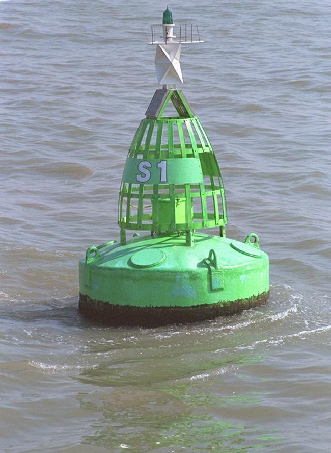
13 LIGHTED BUOYS The bodies (or floats) of lighted buoys may, in principle, be either can shaped (Figure 8.32) or cone shaped (Figure 8.33). The above-water part may vary in shape depending on the type of buoy : general purpose buoy, short pillar buoy or high pillar buoy General purpose buoys General purpose buoys have a cage-work structure built to their body. They have a volume of about 10 m 3 and weigh approximately 5,000 kg. The lights of general purpose buoys are generally powered by solar panels. Before they were powered by acetylene or propane gas. In some countries this may still be the case. The significance of a particular buoy is conveyed by its superstructure and/or topmark and by its colour. The superstructure may be conical (Figure 8.34), cylindrical (can) (Figure 8.35), or spherical (Figure 8.36). The superstructure carries the name or number of the buoy. The lower part of a general purpose buoy is usually cylindrical and draws about 1 metre of water. The buoy is attached to its mooring chain by means of a bridle. The focal height is about 3.5 metres. Figure 8.1 shows a typical general purpose light and bell buoy. Figure Can shaped body Figure Cone shaped body
14 158 Figure 8.34 Conical superstructure Figure 8.35 Can superstructure Figure 8.36 Spherical superstructure NOTES 1. There are no general purpose buoys in the American buoyage system. 2. Some general purpose buoys have no lanterns. These should be considered as ordinary buoys, in which case they usually have a sound device and are then classified as sound buoys. Figure 8.37 shows a general purpose buoy with a conical superstructure, a lantern, and a radar reflector. Figures 8.38 and 8.40 show general purpose buoys with a can superstructure and a radar reflector. Figure 8.39 shows a general purpose buoy with a can superstructure and a topmark. Figure 8.41 shows a general purpose buoy with a spherical superstructure, a lantern, a radar reflector, and no topmark.


15 159 Figure Conical buoy Figure Can buoy Figure Can buoy Figure Can buoy

16 160 Figure Spherical buoy NOTE The buoys shown in Figures 8.37, 8.38, 8.39, 8.40, and 8.41 are buoys used in European waters.

 are distinguished from short pillar buoys by the height of their superstructure. Short pillar buoys have a volume of 10 m 3 a weight of 7,000 kg.")
17 Pillar buoys The superstructure of these buoys is of metal and they have the shape of a frame-work, trellis, or tower. A distinction should be made between the pillar buoys used in European waters and those used in American waters. Pilar buoys are also called tower or tall buoys Pillar buoys used in European waters A distinction should be made between high pillar buoys and short pillar buoys. High pillar buoys (or high focal plane buoys) are distinguished from short pillar buoys by the height of their superstructure. Short pillar buoys have a volume of 10 m 3 a weight of 7,000 kg. and a focal height of 4 metres (Figure 8.42 and 8.44). High pillar buoys have a volume of 20 m 3 a weight of 14,000 kg. and a focal height of 8.5 metres (Figure 8.43 and 8.45). Figure Short pillar buoy European waters Figure High pillar buoy American waters
18 162 Figure Short pillar buoy European waters Figure High pillar buoy European waters Pillar buoys can be identified by their colour and their topmark. In fact, pillar buoys nearly always carry a topmark. They are mostly lighted buoys and the lantern is nowadays powered by solar panels. A circular panel placed just below the lantern or the solar panel(s) carries the number and/or the name of the buoy. The under-water part of the body shown in Figures 8.46 and 8.47 is elongated and cylindrical. Its length is in proportion to the height of the pillar in order to give the buoy sufficient buoyancy and stability. It is fitted with a rudder (Figure 8.47 h) to hold the buoy steady particularly at the turn of the tide. The central part of the body is hollow and partly filled with water up to the water line. The air above the water line is used for operating the whistle. A hanging chain in the tail called `anti fouling chain (Figure 8.46 j) prevents any seaweed from settling on the inner side of the tail.
19 163 BEFORE Figure High pillar buoy a: pillar tower; b: circular panel; c: lantern; d: radar reflector; e: whistle; f: bell; g: body; h: acetylene cylinders; i: tail; j: anti fouling chain NOW Figure High pillar buoy a: pillar tower; b: solar panel; c: lantern; d: topmark; e: radar reflector; f: body; g: tail; h: rudder; i: mooring eye for anchor chain
20 164 Indication of buoys on charts The shapes of buoys, their symbols and abbreviations, are shown in a uniform way on all European charts. Both lighted and unlighted buoys are represented as accurately as possible on charts by a small design depicting the shape of the buoy and topmark. The exact position of the buoy is the centre of the base and is indicated by a small circle. Lighted buoys are shown by a magenta tear drop or light-flare. (See also The lantern.) Symbols representing buoys on charts normally slope to the right, if space permits, otherwise to the left. The standard buoy symbols in use are: a. conical shape: a solid black symbol: b. can shape: an open symbol: c. spherical shape: an open symbol d. pillar buoy: an open symbol or a solid black symbol if it represents a conical buoy (e.g. a starboard hand mark); e. spar buoy: a solid black symbol; f. ordinary beacon: a solid black and upright symbol; NOTE The symbols with diamond shapes and square are used on American charts.
21 g. tower beacon: a solid black symbol when representing a starboard hand mark; otherwise an open symbol; 165 h. floating beacon: a solid black symbol when representing a starboard hand mark; otherwise an open symbol; i. topmarks: solid black symbols, except for a solid red sphere representing a Safe Water mark and a red can indicating a port Lateral mark. REMARKS 1. The above-mentioned symbols are those used in the IALA-System A and B, by the IHO (International Hydrographic Organization) the NOS (National Ocean Service - US) and the NIMA (National Imagery and Mapping Agency - US). For more symbols, see Chart 5011 Symbols and Abbreviations used on Admiralty Charts and particularly Plates L, P, Q, R and S. 2. See also symbols and abbreviations used on marine charts and published by other Administrations. 3. As you may have noticed, buoys on American charts are shown in an entirely different way. 4. For symbols and abbreviations of buoys on European charts, refer to Figures 2.44, 2.46, 2.47, 3.4, 3.6b, 3.15, 3.21, 6.3, and For symbols and abbreviations of buoys on American charts, refer to Figure 2.48 to 2.52.
REGION B ONLY. Figure Figure Figure Figure Figure Figure Figure Figure 10.60
 221 REGION B ONLY 10.5 LATERAL MARKS 10.5.1 Description of Lateral marks Port hand marks Shape: pillar buoy (Figures 10.53 and 10.54), can lighted buoy (Figures 10.55 and 10.56) or not lighted (Figures
 Page 1 of 6 Nav-Aid Basics Unlike the roads and highways that we drive on, the waterways we go boating on do not have road signs that tell us our location, the route or distance to a destination, or of
IALA Buoyage System and Visual Aids to Navigation. by Aleksandr D. Pipchenko
 IALA Buoyage System and Visual Aids to Navigation by Aleksandr D. Pipchenko IALA buoyage regions chart Which types of marks are provided by the system? Six types of marks provided by the system: Lateral
Chapter 8. Port hand buoy. Starboard hand buoy. Canadian Aids to Navigation System (CANS) 8.1 Introduction. 8.2 Lateral Buoys
 8.1 Introduction. 8.2 Lateral Buoys") Chapter 8 Canadian Aids to Navigation System (CANS) 8.1 Introduction Various buoys, beacons and signs are known as "Aids to Navigation" or "Navigation Aids". They are devices or systems external to the
Chapter 8 Canadian Aids to Navigation System (CANS) 8.1 Introduction Various buoys, beacons and signs are known as "Aids to Navigation" or "Navigation Aids". They are devices or systems external to the
Chart Features Maritime maps and Admiralty charts have these features:
 Introduction to Charts A chart or map of the area is an important safety item to carry on board. It allows the Master to obtain knowledge of the area to be travelled, and indicates the navigable channels
National Maritime Center
 National Maritime Center Providing Credentials to Mariners Able Seaman Unlimited, Limited, Special, Special OSV, Sail, Fishing Industry (Sample Examination) Page 1 of 17 Choose the best answer to the following
Aids to navigation can include buoys, day beacons, range markers, and lighthouses.
 This boating safety course manual has been approved by Transport Canada strictly on the basis that it meets the minimum requirements of basic boating safety knowledge set out in Transport Canada s Boating
A buoy, for example is an aid to navigation. Aids to navigation include many types of buoys as well as day beacons, range markers, and lighthouses.
 This online study guide has been approved by Transport Canada strictly on the basis that it meets the requirements of the Standard for Pleasure Craft Operator Testing over the Internet (TP 15080E) and
LES CAHIERS D APPRENTISSAGE MARITIME AIDS TO NAVIGATION AIDS TO NAVIGATION IALA MARITIME BUOYAGE SYSTEM. Page 1 sur 22
 IALA MARITIME BUOYAGE SYSTEM LES CAHIERS D APPRENTISSAGE MARITIME Page 1 sur 22 GENERAL PRINCIPLES OF THE SYSTEM The responsibility for safe navigation resides with the mariner, through the appropriate
National Maritime Center
 National Maritime Center Providing Credentials to Mariners (Sample Examination) Page 1 of 16 Choose the best answer to the following Multiple Choice Questions. 1. On U.S. charts, you can tell if a named
National Maritime Center
 National Maritime Center Providing Credentials to Mariners (Sample Examination) Page 1 of 12 Choose the best answer to the following Multiple Choice Questions. 1. An alternating light. (A) shows a light
2005 ABC. Chapter 3 Part 2. Navigating with ATON's. Revision to D-13 Local Notes. Instructor Notes for Mike Brough. Mike Brough
 2005 ABC Chapter 3 Part 2 Navigating with ATON's Revision to D-13 Local Notes Instructor Notes for Mike Brough Mike Brough June 24 2008 June 24 2008 Slide 1 June 24 2008 New graphics Navigating on Water
Anchoring Is Important
 BCC Sailing Classes - Third Theory Anchoring Anchoring Is Important 1 The Anchor is your last resort. Anchoring Keep off a lee shore. Needs to be shaped (type of anchor) to bury in the type of bottom for
Hydrographic Surveying Methods, Applications and Uses
 Definition: Hydrographic Surveying Methods, Applications and Uses It is the branch of surveying which deals with any body of still or running water such as a lake, harbor, stream or river. Hydrographic
3 Maps and Charts In order to navigate we need to use some form of map. The two choices are nautical charts, or land maps.
 13 3 Maps and Charts In order to navigate we need to use some form of map. The two choices are nautical charts, or land maps. Charts Nautical Charts only show the land detail that is visible from the sea.
National Maritime Center
 National Maritime Center Providing Credentials to Mariners (Sample Examination) Page 1 of 13 Choose the best answer to the following Multiple Choice Questions. 1. What is the approximate geographic range
CHAPTER 5 SHORT RANGE AIDS TO NAVIGATION
 CHAPTER 5 SHORT RANGE AIDS TO NAVIGATION DEFINING SHORT RANGE AIDS TO NAVIGATION 500. Terms and Definitions Short range aids to navigation are those intended to be used visually or by radar while in inland,
CHAPTER 7 SHORT RANGE AIDS TO NAVIGATION
 CHAPTER 7 SHORT RANGE AIDS TO NAVIGATION DEFINING SHORT RANGE AIDS TO NAVIGATION 700. Terms and Definitions A short range/visual Aids to Navigation (ATON) system is a series of interacting external reference
Homework of chapter (3)
") The Islamic University of Gaza, Civil Engineering Department, Fluid mechanics-discussion, Instructor: Dr. Khalil M. Al Astal T.A: Eng. Hasan Almassri T.A: Eng. Mahmoud AlQazzaz First semester, 2013. Homework
The Islamic University of Gaza, Civil Engineering Department, Fluid mechanics-discussion, Instructor: Dr. Khalil M. Al Astal T.A: Eng. Hasan Almassri T.A: Eng. Mahmoud AlQazzaz First semester, 2013. Homework
ATON KIT. (Federal Short Range Aids to Navigation)
") ATON KIT (Federal Short Range Aids to Navigation) Every member while underway on an authorized patrol should check every ATON Federal Short Range Aid to Navigation that they pass and report any observed
ATON KIT (Federal Short Range Aids to Navigation) Every member while underway on an authorized patrol should check every ATON Federal Short Range Aid to Navigation that they pass and report any observed
Nautical Chart Challenge
 Discover Your World With NOAA Nautical Chart Challenge For as long as anyone in his family could remember, Francis Beaufort wanted to make scientific observations from the deck of a ship. In 1789 at the
Presentation Library for Inland ECDIS
 Edition 2.0 1.6.2006 Standard Electronic Chart Display and Information System for Inland Navigation Inland ECDIS for Inland ECDIS In addition to the IHO-S-52 Edition 2.0 IES 20-Section 3 PresLib.doc Page
SECTION I NM 44/16 CHART CORRECTIONS
 CHART CORRECTIONS 1113A (INT 4148) Ed. 2/13 LAST NM 39/16 44/16 Add Buoy 1 G, Fl G 2.5s 26 40.3 N 82 18.9 W 1115A Ed. 10/10 LAST NM 41/16 44/16 11316 42Ed. 6/11 LAST NM 35/16 44/16 28 26 34 N 96 20 42
Gannet Navigation Buoys. jfcmarine.com
 Gannet Navigation Buoys jfcmarine.com Gannet JFC Marine is delighted to introduce our latest additions G1500, G1800 & G2200 Navigation Buoys to our range of marine aids to navigation solutions. These buoys
ADANI PORTS & SEZ LTD. ++ MUNDRA PORT ++ GENERAL INFORMATION
 ADANI PORTS & SEZ LTD. ++ MUNDRA PORT ++ GENERAL INFORMATION LOCATION Mundra Port is all weather, independent, commercial port with geographical and hydrological advantages on the West Coast of India,
An Introduction To Marine Charts
 An Introduction To Marine Charts //captnmike.com Revised August 29, 2011 An Illustrated introduction to U. S. Aids to Navigation in the Shilshole Bay area of Puget Sound, Washington. The chart symbols
WELCOME TO THE. Pleasure Craft Operator Training (PCOC)
") WELCOME TO THE Pleasure Craft Operator Training (PCOC) REGULATIONS The Competency of Operators of Pleasure Craft Regulations require operators of pleasure craft fitted with a motor and used for recreational
WELCOME TO THE Pleasure Craft Operator Training (PCOC) REGULATIONS The Competency of Operators of Pleasure Craft Regulations require operators of pleasure craft fitted with a motor and used for recreational
ENGLISH FOR MASTER OF YACHT
 ATONs LES CAHIERS D APPRENTISSAGE MARITIME Page 1 sur 8 Document complémentaire du cours ATONs Visual Aids in general: Buoyage and Beaconage A Anchorage Buoy A buoy which indicates an anchorage area or
SECTION II CORRECTIONS TO C. G. LIGHT LIST, VOLUME I ATLANTIC COAST, (4) Characteristic. (5) Height
 Characteristic. (5) Height") CORRECTIONS TO C. G. LIGHT LIST, VOLUME I ATLANTIC COAST, 2015 238 University of New Hampshire Lighted Research Wave Buoy 42-47-52.80N 70-10-04.80W FlY 20s Yellow. *Add Note: Aids maintained Apr. 15 to
CORRECTIONS TO C. G. LIGHT LIST, VOLUME I ATLANTIC COAST, 2015 238 University of New Hampshire Lighted Research Wave Buoy 42-47-52.80N 70-10-04.80W FlY 20s Yellow. *Add Note: Aids maintained Apr. 15 to
ELASTIC BEACONS. The widest range of elastic beacons in the world PREMIUM QUALITY
 ELASTIC BEACONS The widest range of elastic beacons in the world PREMIUM QUALITY Introduction to the elastic beacon The complete range of Resinex elastic beacons today offers the most advanced, versatile
AID VERIFIER QUIZ. 1. How often is the Light List published? a. One a year b. Twice a year c. Every Month d. Quarterly
 Qualification as an Aid Verifier in the Auxiliary presumes a knowledge of navigational aids above that of the ordinary member. Questions on the subject may be directed to the AV as he/she is considered
The Marking of Offshore Wind Farms. Provide guidance for a response to IALA. M-4 B445.8 &.9 (& B for on-shore wind farms).
.") CSPCWG2-INF 2 The Marking of Offshore Wind Farms Submitted by: Executive Summary: Chairman (from IALA via IHB) Provide guidance for a response to IALA. Does the Related Project reference have any impact
CSPCWG2-INF 2 The Marking of Offshore Wind Farms Submitted by: Executive Summary: Chairman (from IALA via IHB) Provide guidance for a response to IALA. Does the Related Project reference have any impact
SS&S Chapter 8 Instructor Guide
 SS&S Chapter 8 Instructor Guide The Rules of the Nautical Road The PowerPoints (PPT) slides for this SS&S chapter were copied from the BS&S-13 th Ed PPT because they are identical. Only the chapter numbers
SECTION I NM 5/17 CHART CORRECTIONS
 CHART CORRECTIONS 1116A 79Ed. 2/16 LAST NM 4/17 5/17 Delete Platform 28 22.9 N 90 32.1 W 11301 26Ed. 11/13 LAST NM 47/16 5/17 Delete Light 7 26 03 14 N 97 12 40 W 11302 34Ed. 1/14 LAST NM 15/16 5/17 (Side
CHAPTER I SUEZ CANAL NAVIGATION FEATURES SECTION 1 APPROACHES
 CHAPTER I SUEZ CANAL NAVIGATION FEATURES --------------------- SECTION 1 APPROACHES Art. 8 - PORT SAID: (See Admiralty Charts No. 234, 240 & 241 GENERAL: The Vessels coming from see fifteen miles before
2 Boating Rules and Regulations... 73
 Contents at a Glance Chapter 1 Boat Design and Construction Chapter 2 Boating Rules and Regulations Chapter 3 Navigation Rules (ColRegs) Chapter 4 Boat Operating and Seamanship Chapter 5 Piloting and Navigation
SECTION I NM 25/16 CHART CORRECTIONS
 CHART CORRECTIONS 12221 82Ed. 2/14 LAST NM 23/16 25/16 12224 26Ed. 8/14 LAST NM 23/16 25/16 12225 60Ed. 11/11 LAST NM 23/16 25/16 Delete Light PC 37 43 36 N 75 48 35 W Change Light to 8R Fl R 4s 15ft 4M
Chartwork Learn the basics for position fixing using a number of techniques and a simple equation for speed, distance and time.
 Chartwork Learn the basics for position fixing using a number of techniques and a simple equation for speed, distance and time. Chartwork Chartwork Tools Accurate chart work is the basis for good navigation.
Rules Practice Exam 14
 1 BOTH INTERNATIONAL & INLAND Additional light signals are provided in the Annexes to the Rules for vessels. A. engaged in fishing B. not under command C. engaged in towing D. under sail 2 BOTH INTERNATIONAL
Buoy Product Catalogue
 Buoy Product Catalogue March 2018 Polyethylene Buoys since 1976 For the sustainable use of sea and inland water areas SeaHow provides high-quality expert services and intelligent solutions that support
CHAPTER 9 NAVIGATIONAL DUTIES
 CHAPTER 9 NAVIGATIONAL DUTIES Navigation is the art or science of determining the position of a ship or aircraft and directing that ship or aircraft from one position to another. It can be regarded as
. In an elevator accelerating upward (A) both the elevator accelerating upward (B) the first is equations are valid
 both the elevator accelerating upward (B) the first is equations are valid") IIT JEE Achiever 2014 Ist Year Physics-2: Worksheet-1 Date: 2014-06-26 Hydrostatics 1. A liquid can easily change its shape but a solid cannot because (A) the density of a liquid is smaller than that of
IIT JEE Achiever 2014 Ist Year Physics-2: Worksheet-1 Date: 2014-06-26 Hydrostatics 1. A liquid can easily change its shape but a solid cannot because (A) the density of a liquid is smaller than that of
U.S. Aids To Navigation System
 U.S. Aids To Navigation System Information provided by: United States Coast Guard, Office of Boating Safety (http://www.uscgboating.org/) AIDS TO NAVIGATION... ARE THE ROAD SIGNS OF THE WATERWAYS INTRODUCTION
MARKING OF FISHING GEAR
 IMMARBE International Merchant Marine Registry of Belize Fishing Vessels Circular I FVC-08/03 I MARKING OF FISHING GEAR TO ALL SHIPOWNERS AND OPERATORS, DEPUTY REGISTRARS, RESIDENT AGENTS, RECOGNIZED ORGANIZATIONS
National Maritime Center
 National Maritime Center Providing Credentials to Mariners (Sample Examination) Page 1 of 17 Choose the best answer to the following Multiple Choice questions. 1. The Coast Guard Captain of the Port has
Appendix 2: Presentation Library for Inland ECDIS TABLE OF CONTENTS
 Appendix 2: Presentation Library for Inland ECDIS TABLE OF CONTENTS 1. Lookup Tables... 2 2. Conditional Symbology Procedures... 2 2.1. Top marks... 2 2.2. Daymars... 2 2.3. Restricted areas... 2 2.4.
Plot the Path into the Harbor
 Plot the Path into the Harbor By Mary Anne Otten, Rudyard Area Schools and Joan Chadde, Michigan Technological University Subject/Grade: Grade 3 6, Math, Social Studies, Science Duration: 35 minutes Lesson
BUOYANCY, FLOATATION AND STABILITY
 BUOYANCY, FLOATATION AND STABILITY Archimedes Principle When a stationary body is completely submerged in a fluid, or floating so that it is only partially submerged, the resultant fluid force acting on
Demonstrate basic knowledge of the operation of pleasure/small craft by day
 Page 1 of 7 Title Demonstrate basic knowledge of the operation of pleasure/small craft by day Level 2 Credits 6 Purpose This unit standard is for pleasure craft operators and covers knowledge required
U.S. Aids To Navigation System Brochure U.S. Coast Guard, Office of Aids to Navigation (202) ,
 ,") AIDS TO NAVIGATION Learning Objectives: As a result of this session the participant should: Understand the principal buoyage systems in the United States. Become aware of the characteristics of the buoy
AIDS TO NAVIGATION Learning Objectives: As a result of this session the participant should: Understand the principal buoyage systems in the United States. Become aware of the characteristics of the buoy
Rules Practice Exam 5
 1 BOTH INTERNATIONAL & INLAND Vessel "A" (towing) and vessel "B" are meeting as shown. In this situation, which statement is TRUE? Diagram 12 A. Both vessels should alter course to starboard and pass port
NavRule Practice Exam, 70 Series Practice April 18, Labeled C have been copied to collection
 1C. INTERNATIONAL & INLAND There are two classes of vessel which, to the extent necessary to carry out their work, do not have to comply with the rule regarding traffic separation schemes. One of these
THE CANADIAN AIDS TO NAVIGATION SYSTEM
 (TP968) THE CANADIAN AIDS TO NAVIGATION SYSTEM Safety First, Service Always (TP968) THE CANADIAN AIDS TO NAVIGATION SYSTEM Canadian Coast Guard Maritime Services Aids to Navigation Program This publication
Transom. Stern. Starboard side. Stem between planing and displacement hulls. Sample. page
 Chapter 1 Review questions 1. Label the illustration of the boat opposite using the list of terms provided. Bow, stern, port side, all-round light, stem, transom, deck, portside, starboard side, coaming,
National Maritime Center
 National Maritime Center Providing Credentials to Mariners (Sample Examination) Page 1 of 17 Choose the best answer to the following Multiple Choice questions. 1. The Coast Guard Captain of the Port has
Stars and Compass Trophy and Novice Paper 2014!
 Stars and Compass Trophy and Novice Paper 2014 The Stars and Compass Trophy was established to promote the use and development of traditional navigation skills. This year, in a bid to encourage novice
Admiralty Leisure Folio SC5601 East Devon and Dorset Coast, Exmouth to Christchurch
 Admiralty Leisure Folio SC5601 East Devon and Dorset Coast, Exmouth to Christchurch The Notices to Mariners (NMs) listed below apply to the latest edition of SC5601 (11 th Edition) published on 24 th March
National Maritime Center
 National Maritime Center Providing Credentials to Mariners (Sample Examination) Page 1 of 17 Choose the best answer to the following Multiple Choice questions. 1. Which is TRUE concerning privately maintained
Visiting Lake Macquarie
 Visiting Lake Macquarie Lake Macquarie is the largest coastal salt water lake in Australia and is a prime boating destination for both small and large vessels. Many sailing regattas and fishing activities
OPERATIONS SEAFARER CERTIFICATION GUIDANCE NOTE SA MARITIME QUALIFICATIONS CODE. Deck: Chart Work
 Page 1 of 6 Compiled by Approved by Chief Examiner Syllabus Committee: 26 February 2013 OPERATIONS SEAFARER CERTIFICATION GUIDANCE NOTE SA MARITIME QUALIFICATIONS CODE Deck: Chart Work Page 2 of 6 COLUMN
AUS small scale charts for coastal navigation. Scale: 1 to 150,000
 CHART-WORK SCALE Charts are available in different scales depending on their use. For passage planning you would use small scale charts and for close quarter manoeuvring you would use larger scale charts
THEORY PRACTICE PAPER /
 THEORY PRACTICE PAPER http://www.uspowerboating.com / http://www.boatsafe.com http://www.singaporetests.com NAUTICAL TERMS 1. What does the term "draught of the vessel" mean :- a. depth of the vessel below
CLIENT NAME: LOCATION: CALM BUOY INSPECTION:
 INSPECTOR REVIEWED INSPECTION OF CALM BUOY OVERALL PHOTO REVISION DESCRIPTION: Preliminary / Final Page: 1 TABLE OF CONTENT 1. MANAGEMENT SUMMARY... 3 1.1. SCOPE OF WORK:... 3 1.2. CORRECTIVE ACTIONS...
CHAPTER 4: BEST MANAGEMENT PRACTICES FOR EROSION AND SEDIMENTATION CONTROL
 Figure 4.4m. Type III Floating Turbidity Barrier Source: American Boom and Barrier Corporation and Virginia Department of Transportation (DOT) Standard Sheets 71 4.4.6 Floating Turbidity Barrier Definition
Rocks, Wrecks, Obstructions, Aquaculture K
 General 1 Danger line: A danger line draws attention to a danger which would not stand out clearly enough if represented solely by its symbol (e.g. isolated rock) or delimits an area containing numerous
THE REPUBLIC OF LIBERIA LIBERIA MARITIME AUTHORITY
 THE REPUBLIC OF LIBERIA LIBERIA MARITIME AUTHORITY 8619 Westwood Center Drive Suite 300 Vienna, Virginia 22182, USA Tel: +1 703 790 3434 Fax: +1 703 790 5655 Email: safety@liscr.com Web: www.liscr.com
Order no. 939 of 27 November 1992 on the protection of submarine cables and submarine pipelines (the Cable Order)
") Order no. 939 of 27 November 1992 on the protection of submarine cables and submarine pipelines (the Cable Order) Pursuant to Section 5(4) and Section 6(3) of the Act on Safety of Navigation, cf. Consolidated
Order no. 939 of 27 November 1992 on the protection of submarine cables and submarine pipelines (the Cable Order) Pursuant to Section 5(4) and Section 6(3) of the Act on Safety of Navigation, cf. Consolidated
Engineering Surveying - II CE313. Hydrographic Survey Lecture 06 Muhammad Noman
 Engineering Surveying - II CE313 Hydrographic Survey Lecture 06 Muhammad Noman Hydrographic Surveying Hydrographic surveying is the branch of the survey which deal with any body of still or running water
LANGLEY SQUADRON MID-TERM KNOWLEDGE CHECK
 LANGLEY SQUADRON MID-TERM KNOWLEDGE CHECK Seamanship 1. (d) only (a) and (c) 2. (d) all of the above 3. (a) chocks 4. (a) placed at the end of the cord and the tool plugged directly in (a) Inboard Direct
Marine Law Enforcement Training Program (MLETP) training materials: maritime operations,
 training materials: maritime operations,") Description of document: Requested date: Released date: Posted date: Source of document: Federal Law Enforcement Training Centers (FLETC) Marine Law Enforcement Training Program (MLETP) training materials:
Description of document: Requested date: Released date: Posted date: Source of document: Federal Law Enforcement Training Centers (FLETC) Marine Law Enforcement Training Program (MLETP) training materials:
THE SYLLABUS FOR WRITTEN EXAMINATION PILOT'S FOURTH CLASS LICENCE (TEES AND HARTLEPOOL) AND
 AND") PD TEESPORT CONSERVANCY DIVISION HARBOUR MASTER'S OFFICE THE SYLLABUS FOR WRITTEN EXAMINATION IN RESPECT OF A PILOT'S FOURTH CLASS LICENCE (TEES AND HARTLEPOOL) AND PILOTAGE EXEMPTION CERTIFICATE (Issued
PD TEESPORT CONSERVANCY DIVISION HARBOUR MASTER'S OFFICE THE SYLLABUS FOR WRITTEN EXAMINATION IN RESPECT OF A PILOT'S FOURTH CLASS LICENCE (TEES AND HARTLEPOOL) AND PILOTAGE EXEMPTION CERTIFICATE (Issued
HMS Colossus Dive Trail
 HMS Colossus Dive Trail HMS Colossus Dive Trail Read this page before the dive HMS Colossus was a 74 gun warship built in 1787 at Gravesend and wrecked in 1798. These 74 gun ships were one of the most
V Complying with IHO S-52/S-63/S-64
 Model FEA-2107/2807 V.06.50 Complying with IHO S-52/S-63/S-64 The software has been upgraded to V.06.50 in accordance with the IHO standards. IHO S-52 Ed. 6.1.1 Specifications for Chart Contents and Display
An Ocean of Possibility
 An Ocean of Possibility SPM Offloading Buoy CALM Buoy Orwell Offshore s Catenary Anchor Leg Mooring (CALM) Buoy offers a reliable state-of-the-art solution for loading and offloading crude oil, refined
Plot the Path. Mary Anne Otten. lesson three
 Plot the Path Mary Anne Otten lesson three Subject/Grade: Grade 2, Math, Social Studies, Science Duration: one class period Materials needed: Per class: Day the Great Lakes Drained Away by Charles Ferguson
BOAT CREW HANDBOOK Navigation and Piloting
 BOAT CREW HANDBOOK Navigation and Piloting Captain John A. Henriques BCH 16114.3 December 2017 John Ashcroft Henriques John Ashcroft Henriques was one of the most important Revenue Cutter Service officers
No MAY 2017 UNITED STATES OF AMERICA. Contents
 21 27 MAY 2017 UNITED STATES OF AMERICA Published Weekly by the National Geospatial-Intelligence Agency Prepared Jointly with the National Ocean Service and U.S. Coast Guard Contents Section I Chart Corrections............................................
Chart Specifications of the IHO Publication S-4 (Formerly M-4)
") TWLWG3/4/11A Publication S-4 (Formerly M-4) Attached to this document is an extract from IHO Publication S-4 which relate to Tidal and Water Level Information. The TWLWG is requested to review this information
TWLWG3/4/11A Publication S-4 (Formerly M-4) Attached to this document is an extract from IHO Publication S-4 which relate to Tidal and Water Level Information. The TWLWG is requested to review this information
U. S. Coast Guard Sector Boston Merrimack River Approach and Entrance, MA. Waterways Management Survey
 U. S. Coast Guard Sector Boston Merrimack River Approach and Entrance, MA. Waterways Management Survey The Waterways Analysis and Management Survey (WAMS) process is an essential component of both the
SECTION I NM 6/17 CHART CORRECTIONS
 SECTION I NM 6/17 CHART CORRECTIONS 50 (INT 50) 9Ed. 12/15 LAST NM 8/16 6/17 Delete Superbuoy DART 46402 51 04 N 164 01 W Change Color of superbuoy DART 46403 Y 52 39 N 156 56 W Add Superbuoy DART [Q58]
Rules Practice Exam 7
 1 INTERNATIONAL ONLY The light which may be used with a vessel's whistle is to be. A. used when the whistle is broken B. used prior to sounding the whistle C. used only at night D. a white light 2 INTERNATIONAL
PHYS 101 Previous Exam Problems
 PHYS 101 Previous Exam Problems CHAPTER 14 Fluids Fluids at rest pressure vs. depth Pascal s principle Archimedes s principle Buoynat forces Fluids in motion: Continuity & Bernoulli equations 1. How deep
DISCUSSION PAPER: NEW GENERALISATION POLICY FOR SMALL SCALE ADMIRALTY CHARTS.
 DISCUSSION PAPER: NEW GENERALISATION POLICY FOR SMALL SCALE ADMIRALTY CHARTS. PREFACE. Throughout this paper we will be making reference to largest scale, second scale, third scale coverage on an SNC (Standard
NCI Manual Part 3 Station Operations & Training. Section 3 Training Guidance Notes. B Distress, Urgency & other Signals
 National Coastwatch NCI Manual Part 3 Station Operations & Training Section 3 Training Guidance Notes B Distress, Urgency & other Signals Station Administration Group NCI Manual 303.2B-1 www.nci.org.uk
National Maritime Center
 National Maritime Center Providing Credentials to Mariners (Sample Examination) Page 1 of 17 Choose the best answer to the following Multiple Choice questions. 1. Your vessel is steering 263 T at 22 knots.
SECTION II CORRECTIONS TO C. G. LIGHT LIST, VOLUME I ATLANTIC COAST, (4) Characteristic. (5) Height
 Characteristic. (5) Height") CORRECTIONS TO C. G. LIGHT LIST, VOLUME I ATLANTIC COAST, 2013 3531 Castine DeepC Wind North Anchor Lighted Buoy NE 3531 Castine DeepC Wind West Anchor Lighted Buoy W 3532 Castine DeepC Wind East Anchor
CORRECTIONS TO C. G. LIGHT LIST, VOLUME I ATLANTIC COAST, 2013 3531 Castine DeepC Wind North Anchor Lighted Buoy NE 3531 Castine DeepC Wind West Anchor Lighted Buoy W 3532 Castine DeepC Wind East Anchor
Pioneer Array Micro-siting Public Input Process Frequently Asked Questions
 Pioneer Array Micro-siting Public Input Process Frequently Asked Questions The National Science Foundation (NSF) has completed the micro-siting of the moored array of the Ocean Observatories Initiative
Module 3: Hydrostatic forces on submerged bodies Lecture 7: Calculation of horizontal component, buoyancy. Forces on submerged bodies (continued)
") Forces on submerged bodies (continued) Buoyancy file:///d /Web%20Course/Dr.%20Nishith%20Verma/local%20server/fluid_mechanics/lecture7/7_1.htm[5/9/2012 3:05:26 PM] Forces on submerged bodies (continued)
Forces on submerged bodies (continued) Buoyancy file:///d /Web%20Course/Dr.%20Nishith%20Verma/local%20server/fluid_mechanics/lecture7/7_1.htm[5/9/2012 3:05:26 PM] Forces on submerged bodies (continued)
NETLAKE guidelines for automated monitoring system development
 Page 2 NETLAKE guidelines for automated monitoring system development Objective 001 Options for buoy design In this factsheet, we describe some of the options that can be used to house an automatic monitoring
FC-CIV HIDRCANA: Channel Hydraulics Flow Mechanics Review Fluid Statics
 FC-CIV HIDRCANA: Channel Hydraulics Flow Mechanics Review Fluid Statics Civil Engineering Program, San Ignacio de Loyola University Objective Calculate the forces exerted by a fluid at rest on plane or
No JUNE 2017 UNITED STATES OF AMERICA. Contents
 23 10 JUNE 2017 UNITED STATES OF AMERICA Published Weekly by the National Geospatial-Intelligence Agency Prepared Jointly with the National Ocean Service and U.S. Coast Guard Contents Section I Chart Corrections............................................
2 Available: 1390/08/02 Date of returning: 1390/08/17 1. A suction cup is used to support a plate of weight as shown in below Figure. For the conditio
 1. A suction cup is used to support a plate of weight as shown in below Figure. For the conditions shown, determine. 2. A tanker truck carries water, and the cross section of the truck s tank is shown
Unit 18 LEAVING THE DOCK
 Unit 18 LEAVING THE DOCK Basic terms - Dock Pilot - River Pilot - tug-boat - transverse thrust - effect of the screw - singling up - mooring ropes - skipper - handling of ships - buoys - dolphins - slack
Reliable partners for over 100 years delivering solutions worldwide CAGE FARMING EQUIPMENT
 Reliable partners for over 100 years delivering solutions worldwide CAGE FARMING EQUIPMENT SUBMERSIBLE AND FLOATING CAGES OVERVIEW SUBMERSIBLE CAGES The use of submersible cages allows farmers to develop
National Maritime Center
 National Maritime Center Providing Credentials to Mariners U.S.C.G. Merchant Marine Exam (Sample Examination) Page 1 of 22 U.S.C.G. Merchant Marine Exam: Illustrations: 10 Choose the best answer to the
Exam Question 9: Hydrostatics. March 6, Applied Mathematics: Lecture 8. Brendan Williamson. Introduction. Density, Weight and Volume
 Exam Question 9: Hydrostatics March 6, 2017 This lecture is on hydrostatics, which is question 9 of the exam paper. Most of the situations we will study will relate to objects partly or fully submerged
National Maritime Center
 National Maritime Center Providing Credentials to Mariners Q382 Navigation General-Rivers (Sample Examination) Page 1 of 14 Choose the best answer to the following Multiple Choice Questions. 1. The Light
Rule 26 - Fishing vessels
 (a) A vessel engaged in fishing, whether underway or at anchor, shall exhibit only the lights and shapes prescribed in this Rule. (b) A vessel when engaged in trawling, by which is meant the dragging through
Preventing Damage to Harbour Facilities and. Ship Handling in Harbours PART 2 INDEX
 Preventing Damage to Harbour Facilities and Ship Handling in Harbours PART 2 INDEX 1 Vessel handling is based on the basic knowledge that a vessel floats in the water and returns to its original position
Ocean Observatories Initiative (OOI) Moorings: New Capabilities for Seagoing Science
 Moorings: New Capabilities for Seagoing Science") Ocean Observatories Initiative Ocean Observatories Initiative (OOI) Moorings: New Capabilities for Seagoing Science presented by Ed Dever and Walt Waldorf November 20, 2014 OOI Science Themes Coastal and
Ocean Observatories Initiative Ocean Observatories Initiative (OOI) Moorings: New Capabilities for Seagoing Science presented by Ed Dever and Walt Waldorf November 20, 2014 OOI Science Themes Coastal and