Crown Point Avalanche Incident January 4 th, 2017
|
|
|
- Tyrone Martin
- 6 years ago
- Views:
Transcription
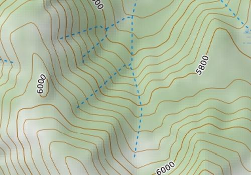
1 Crown Point Avalanche Incident January 4 th, 2017 Report by Dennis D Amico and Ian Nicholson Incident snapshot Occurrence Time and Date: 1100 am on January 4th, 2017 Location: Crown Point, Pickhandle Basin, Pierce Co., Mt Baker-Snoqualmie NF, WA Number in Party: 3 Number Caught: 1 Number Partially Buried, Not-critical: 1 (Arrested on top of debris, head was exposed) Number Injured: 1 Avalanche Type: Hard Slab (Wind Slab) Trigger: Skier Size: R (not estimated) / D2 Start Zone Aspect: West Start Zone Angle: degrees Start Zone Elevation: 6030 ft (estimated) Height of Crown Face: not observed Average Width of Fracture: ft Vertical Fall: not observed, person caught and carried 240 ft Slab Characteristics: Pencil Hardness, Decomposing and Fragmented Particles Terrain trap: Trees Number of people that crossed start zone before avalanche: 0 Avalanche occurred during: Ascent Location of group in relation to start zone during avalanche: Middle Avalanche Safety Gear Carried: All three had transceiver, probe and shovel. Person caught had an airbag pack and deployed the airbag. Avalanche Training and Experience at Activity: Advanced-Expert for person caught, unknown for others. Signs of Instability Noted by Group: Shooting cracks, recent avalanches. Extent of Injuries: Several areas of bruising and swelling. NWAC Forecast Zone: West Slopes South South of I-90 to Columbia River Avalanche Danger Rating (Near Treeline): Moderate Northwest Avalanche Center
2 NWAC Comments On the same day as Ian s incident, an avalanche fatality occurred less than 2 miles away in Silver Basin where a solo skier triggered a hard wind slab and was carried several hundred feet. We hope by sharing Ian s incident we can all learn from what could have easily had a more serious outcome. Internally, NWAC will also process and learn from the incident. Incident Summary by Ian Nicholson (NWAC Professional Observer) During a work day employed as a Professional Observer for NWAC, I triggered an avalanche approaching the SW ridge of Crown Point in the near treeline or potentially the upper portion of the below treeline elevation band. I was nearly directly in-line with the summit of Crown Point on its west face at 6000ft. The Crystal summit weather station recorded gusts over 100 mph from the east (the upper lifts for the ski area did not run due to high winds on 1/4/17). Winds had redistributed snow well into the below treeline band and created stiffer wind slabs much further from ridges and exposed features than we had anticipated. We were working our way up lower angled terrain below treeline while approximately 250+ft horizontal from the ridge through mostly treed terrain. When our group of three skiers encountered an opening in the trees, I stopped my partners in the trees as this was the first steep-ish section of terrain we encountered. As I skinned forward and over only two ski lengths, the snow surface changed from 4F to P hardness wind board and became hollow sounding. Still on the edge of the piece of steep terrain, I expressed my concern with my partners and dug a hand-pit finding 15 cm (6 ) P hard wind stiffened snow above weaker snow. Due to the conditions encountered, we had already been toning down our objectives for the day and had already ruled out our first two options because of much more widespread wind slab development than we had originally anticipated. We started to discuss turning around at that moment and I decided to push down on the edge of the skin track. I heard a crack and felt the slope begin to slide. I immediately pulled my airbag still thinking the avalanche wouldn't be as big as it was. The avalanche was roughly ft wide, broke 30 ft above me, and I was carried for 240 ft vertical downhill and through trees. I triggered the avalanche on a roughly 35 degree slope that did connect to slopes above it in the degree range. I was not buried, but lost one ski, glasses, poles and my hat. Where I stopped, the debris was about cm deep. I did not incur any major injuries although I received bruises on my left tricep and lower left hip and back as well as swelling in my right ankle (the foot that my ski was torn off of and boot subsequently half-way removed) and three fingers on my left hand. All injuries were from hitting trees. It s worth noting that I remember hitting the back of my head on my airbag after impacting the first tree while sliding backwards at fairly significant speed. I did not need to visit a medical facility after the incident. Northwest Avalanche Center

3 Ian performing a skin track test prior to the avalanche Northwest Avalanche Center

4 Looking uphill at the avalanche path. Ian hit and stopped in the trees directly uphill in the photo and in-line with the spot marked Trigger Point. Active wind transport is occurring off the peak Northwest Avalanche Center
5 Northwest Avalanche Center


6


7 West Slopes South - South of I-90 to Columbia River Issued: 6:00 PM PST Tuesday, January 3, 2017 by Garth Ferber NWAC avalanche forecasts apply to backcountry avalanche terrain in the Olympics, Washington Cascades and Mt Hood area. These forecasts do not apply to developed ski areas, avalanche terrain affecting highways and higher terrain on the volcanic peaks above the Cascade crest level. A preliminary incident report completed by the White Pass Ski Patrol and NWAC for the avalanche fatality that occurred on Tuesday, December 27th, 2016 is now available on the NWAC accidents page. The Bottom Line: Further building or new wind slab should be the main avalanche problem on Wednesday. Be sure to read the forecast since wind slab may build on aspects where you don't expect it. Elevation Wednesday Above Treeline Considerable Near Treeline Moderate Below Treeline Moderate Outlook for Thursday Dangerous avalanche conditions. Careful snowpack evaluation, cautious route-finding and conservative decision-making essential. Considerable Heightened avalanche conditions on specific terrain features. Evaluate snow and terrain carefully; identify problem features. Moderate Heightened avalanche conditions on specific terrain features. Evaluate snow and terrain carefully; identify problem features. Moderate Avalanche Problems for Wednesday Wind Slab Wind slabs can take up to a week to stabilize. They are confined to lee and cross-loaded terrain features and can be avoided by sticking to sheltered or wind scoured areas. Avalanche Problem Aspect/Elevation Likelihood Size
8 Snowpack Analysis Weather and Snowpack A low pressure system moved south over western Washington on Saturday night followed by cold Arctic air. NWAC stations along the west slopes had W-SW winds Saturday and 5-13 inches of snowfall by Sunday morning. An unusual moist reverse orographic east flow caused snow mainly in the central to south Cascades Sunday afternoon and night. NWAC stations along the west slopes had a shift to NE winds and another 0-10 inches of snow on Monday morning with the most snow in the central to south part and further cooling. Fair cold weather with east winds has been seen on Monday and Tuesday with clouds lingering from the Columbia Basin to the Cascade east slopes and the east side of Mt Hood. Recent Observations Consistent observations were received on New Year's Day from three NWAC pro-observer's out enjoying the after champagne, champagne powder! Their reports from the Mt Baker area, Stevens Pass and the Alpental Valley all indicated deep, low density surface conditions, right side profiles and good skiing. Crusts layers were buried fairly deeply and unreactive in tests (Solstice crust at Snoqualmie buried 90 cm on average). East winds began to affect some areas by Monday. The NPS ranger at Paradise on Monday reported low visibility with significant snow transport to SW-W slopes on Monday. A couple reports area available via the NWAC Observations tab. A report from the Artist Point/Table Mountain area near Mt Baker indicated continued good stability with some wind slab starting to form on Monday. A skier on Mt Roosevelt at Snoqualmie Pass triggered a inch wind slab and was carried but not injured in a WNW couloir on Monday. Detailed Avalanche Forecast for Wednesday Fair cold weather is generally expected to continue over the Olympics and Cascades on Wednesday. Low clouds will probably linger from the Columbia Basin to the Cascade east slopes and the east side of Mt Hood. But expect locally strong east winds to develop over the Olympics and Washington Cascades Tuesday night and Wednesday. Therefore new or further building wind slab should be the main avalanche problem on Wednesday. This new wind slab should be found mainly on NW to SE aspects on Wednesday especially at exposed locations such as around Snoqualmie, Crystal Mountain, Paradise and White Pass. There should be quite a bit of recent snow available for transport. Watch for firmer wind transported snow and remember that stiffer wind slab has the potential to propagate to larger avalanches. Although NW to SE aspects will be indicated in the wind slab avalanche problem diagram remember to watch for firmer wind transported snow on all slope aspects or cross loaded slopes especially in areas with varied terrain and modified wind directions. Older wind slab may also linger on other slope aspects. Mountain Weather Synopsis for Wednesday & Thursday An elongated E-W oriented upper level trough over central Oregon is causing some light snow for Mt. Hood and the far south Washington Cascades this morning. This trough will drift south during the the day and weaken, allowing for a clearing trend over these areas. Further north, it's clear and very cold. East winds will be moderate to strong at Pass and crest level today. Winds should ease over the north Cascades this morning but stay elevated for the south and central Washington Cascades through mid-afternoon. Upper level ridging over the NE Pacific will build into Britsh Columbia overnight turning our flow aloft northerly and allowing winds to ease over the region. A weak shortwave upstream in NW flow aloft will begin to slide south along the B.C. coast Thursday, spreading increasing clouds into the north Cascades and Olympics and producing a few light snow showers through Thursday night. Temperatures should slowly moderate on Thursday and Thursday night. Free Winds at 5000' (in Miles per Hour (MPH)) Date Olympics Northwest Cascades Central Cascades South Cascades Wednesday Morning ENE ENE E E Wednesday Afternoon - Wednesday Evening ENE 5-15 ENE E E Wednesday Night - Thursday Morning N 0-10 VAR 0-10 E 0-10 E Thursday Afternoon - Thursday Night NW 5-15 SW 0-10 SW 0-10 W 0-10 Directions above indicate the direction the wind blows from on the 16-point cardinal scale. These winds and the 9000 ft winds below also indicate "free" winds, or those winds in the atmosphere not influenced by terrain. Topographical effects may produce greater or lower wind speeds in certain locations as well as significant variations in direction. Free Winds at 9000' (in Miles per Hour (MPH)) Date NW Cascades NE Cascades Central Cascades South Cascades Wednesday Morning ENE ENE E E Wednesday Afternoon NE NE ENE E Wednesday Night NE NE 5-15 NE E Thursday Morning N 5-15 NW 5-15 NE 5-15 NE Thursday Afternoon - Thursday Night W W NW NW 10-20
9 24 Hour Quantitative Precipitation ending at 4 am Snow Level/Freezing Level in feet Location Thu Fri Hurricane Ridge 0 lt.10 Mt Baker Ski Area 0 lt.10 Washington Pass 0 0 Stevens Pass 0 0 Snoqualmie Pass 0 0 Mission Ridge 0 0 Crystal Mt 0 0 Paradise 0 0 White Pass 0 0 Day Northwest Northeast Central South Olympics Cascades Cascades Cascades Cascades Easterly Wednesday - Thursday 0' 0' 0' 0' 0' * Thursday Night 1000' 0' 0' 0' 0' * Flow in Passes Cascade Snow / Freezing Levels noted above refer to the north (approximately Mt Baker and Washington Pass), central (approximately Stevens to White Pass) and south (near Mt Hood). Freezing Level is when no precipitation is forecast. * Note that surface snow levels are common near the passes during easterly pass flow and may result in multiple snow / freezing levels. Mt Hood Meadows 0 0 Timberline 0 0 LT = less than; WE or Water equivalent is the liquid water equivalent of melted snow in hundredths of inches. As a rough approximation 1 inch of snow = about.10 inches WE, or 10 inches of snow = about 1 inch WE.
Mt Hood Meadows Avalanche Accident
 Mt Hood Meadows Avalanche Accident February 28, 2011 Date: Noon on Monday, 2/28/2011 Submitted by: Joe Sillman, Mt Hood Meadows Pro Patrol and Mark Moore, NWAC Place: Heather Canyon Drainage, Backyards,
12/14/2015 Idaho Bald Mountain Sidecountry Published by Scott Savage, SAC
 Location: Place Christmas Eve, Bald Mountain Sidecountry State Idaho Date 12/14/2015 Time 1135 Summary 1 skier partially buried and injured due to striking trees Number: Caught 1 Fully Buried 0 Injured
GRANITE MOUNTAIN (5629 ) AVALANCHE INCIDENT March 10, Narrative provided by John Stimberis WSDOT Avalanche Technician, Snoqualmie Pass
 AVALANCHE INCIDENT March 10, Narrative provided by John Stimberis WSDOT Avalanche Technician, Snoqualmie Pass") Page 1 of 9 GRANITE MOUNTAIN (5629 ) AVALANCHE INCIDENT March 10, 2002 Narrative provided by John Stimberis WSDOT Avalanche Technician, Snoqualmie Pass Accident Narrative On March 10, 2002, two Seattle
Page 1 of 9 GRANITE MOUNTAIN (5629 ) AVALANCHE INCIDENT March 10, 2002 Narrative provided by John Stimberis WSDOT Avalanche Technician, Snoqualmie Pass Accident Narrative On March 10, 2002, two Seattle
Near Miss Avalanche Incident Jan 3 rd, 2014
 Near Miss Avalanche Incident Jan 3 rd, 2014 Location: Turnagain Pass Tincan mountain - Lower CFR, West aspect Summary Tincan avalanche, dog fully buried, presumed dead January 3rd, 2014 2:50pm HS-AO-D2.5-R2.5-O/G
3/8/2016 Oregon Wallowa Mountains Published by Michael Hatch (Wallowa Avalanche Center) and Scott Savage (on behalf of USFS National Avalanche Center)
 and Scott Savage (on behalf of USFS National Avalanche Center)") Location: Place Chief Joseph Peak, Wallowa Mountains State Oregon Date 3/8/2016 Time 1630 hrs Summary 1 skier partially buried and killed Number: Caught 1 Fully Buried 0 Injured 0 Killed 1 Avalanche Details:
Location: Place Chief Joseph Peak, Wallowa Mountains State Oregon Date 3/8/2016 Time 1630 hrs Summary 1 skier partially buried and killed Number: Caught 1 Fully Buried 0 Injured 0 Killed 1 Avalanche Details:
2016/04/03 Alaska Hoodoo Mountains, Eastern Alaska Range Published by Conrad Chapman Eastern Alaska Range Avalanche Center
 2016/04/03 Alaska Hoodoo Mountains, Eastern Alaska Range Published by Conrad Chapman Eastern Alaska Range Avalanche Center Avalanche Details Date: 03 April 2016 Time: 3:00 pm AST Location: Hoodoo Mountains,
Morse Creek Drainage Avalanche Accident March 7, 2004
 Morse Creek Drainage Avalanche Accident March 7, 2004 Date: Avalanche occurred around 1:30pm, Sunday March 7, 2004. Location: In the Morse Creek drainage, just south of Three Way Peak, just beyond the
Union Creek Avalanche Accident
 Union Creek Avalanche Accident February 19, 2012 Date: 2/19/2012 Location: Union Creek Basin. Back country east of Crystal Mountain Resort. Summary: Three skiers triggered and caught by ~20-inch deep X
Chris Simmons. IFMGA/AMGA Mountain Guide
 Justin Robinson and Wesley McCain climbed the North Face of Chair Peak on Tuesday, 15 January. Unconsolidated snow caused them to climb much more slowly than anticipated, and they found themselves re-entering
Snow Avalanches. Basic Principles for Avoiding and Surviving Snow Avalanches. By Lance Young
 Snow Avalanches Basic Principles for Avoiding and Surviving Snow Avalanches By Lance Young Introduction Snow avalanches are complex natural phenomena, experts do not fully understand all their causes.
SHUKSAN ARM AVALANCE ACCIDENT, 2/14/1999
 SHUKSAN ARM AVALANCE ACCIDENT, 2/14/1999 Date & Time 2-14-1999, ~1220 PM PST Location Rumble Gully below Shuksan Arm in the Mt Baker Wilderness, just east of the eastern boundary of the Mt Baker Ski Area
Avalanche Problem Essentials Wind Slabs. Development
 1 Avalanche Problem Essentials Wind Slabs This document is part of Decision Making in Avalanche Terrain: a fieldbook for winter backcountry users by Pascal Haegeli, Roger Atkins and Karl Klassen and provides
Butch Mountain avalanche January 29 th Synopsis
 Butch Mountain avalanche January 29 th 2011 Synopsis Four skiers triggered an avalanche on Butch mountain that broke above them as they were ascending on skins. All four were caught and carried through
Dude Mountain Avalanche Accident Report Ketchikan, Southeast Alaska
 Dude Mountain Avalanche Accident Report Ketchikan, Southeast Alaska Location: Dude Mountain NW Bowl (5 ½ miles due north of Ketchikan, Alaska) Lat/Long: 55.41862 o N, -131.61829 o W (WGS84) burial site
Loose Dry Avalanches
 Loose Dry Avalanches Introduction Loose dry avalanches are usually confined to surface layers, and therefore are often small. They contain loose cohesion less dry powdery snow. They start from a point
Sparkle Party Avalanche Incident Report 2/28/2010. Compiled by Ben Wright Paul Baugher Chet Mowbray Mark Moore
 Sparkle Party Avalanche Incident Report 2/28/2010 Compiled by Ben Wright Paul Baugher Chet Mowbray Mark Moore Sparkle Party Avalanche Incident Report Table of Contents Sparkle Party Avalanche Incident
*** FULL REPORT FROM THE WCMAC *** View report and photos online at:
 Date: 2014-05-03 Submitted By: Steve Karkanen, West Central Montana Avalanche Center (WCMAC) Place: Olson Gulch, Flint Creek Range, 10 miles NW of Anaconda, MT State: MT Country: USA Fatalities: 1 Summary:
AVALANCHE! Yell it out!
 AVALANCHE! Yell it out! by Dave Galvin We live and recreate in the corner of the globe (do globes really have corners?) with the largest snowfall on record (world record is held by Mt. Baker Ski Area @1,140
Hatch Peak Avalanche Fatality
 Hatch Peak Avalanche Fatality Date: 19 March 2011 Place: Hatch Peak (Hatcher Pass area, Talkeetna Mountains) State: Alaska Fatalities: 1 Summary: 2 skiers caught, 1 partially buried and 1fully buried and
AVALANCHE ACCIDENT - GLADIATOR RIDGE
 AVALANCHE ACCIDENT - GLADIATOR RIDGE SUBMITTED BY: Sawtooth National Forest Avalanche Center LOCATION: 20 Miles Northwest of Sun Valley, ID DATE: March 6, 2009 SUMMARY: 1 skier caught, buried and killed;
AVALANCHE ACCIDENT Aneroid Basin, Wallowa Mountains, Oregon
 AVALANCHE ACCIDENT Aneroid Basin, Wallowa Mountains, Oregon LOCATION: Lookout Mt, Eagle Cap Wilderness, Wallowa Mountains, OR; Accident ~10 Miles south of Joseph, OR DATE: March 7, 2009, approximately
International Snow Science Workshop
 EXTENDED COLUMN TEST RESULTS DURING SURFACE WARMING: DOES SURFACE WARMING AFFECT FRACTURE PROPAGATION POTENTIAL? Ron Simenhois 1,2,* and Karl Birkeland 3 1 Copper Mountain Ski Area, Copper Mountain, Colorado
from the PSIA Nordic Team February, 2014
 news from the PSIA Nordic Team February, 2014 d Nord News d Nord is a fabrication of the PSIA Nordic Team. Divisions are welcome to reprint partial or complete articles from here at will (with credit)
24 -Day Utah Ski and Snowboard Mountaineering Leadership & Guide Training Course Information
 24 -Day Utah Ski and Snowboard Mountaineering Leadership & Guide Training Course Information Course Location Utah has a series of lofty ranges that offer incredible mountaineering, skiing, and climbing.
Pointe de la Pierre. Avalanche accidents in Italy
 Pointe de la Pierre Avalanche accidents in Italy Season 2015-2016 winter 2015-2016 italian Alps summary: first snowfall in October then warm and no snow in November and December zero level many days: November
Denali National Park - Motorcycle Hill avalanche with 4 fatalities
 Denali National Park - Motorcycle Hill avalanche with 4 fatalities Location: Motorcycle Hill, West Buttress Mt. McKinley Date: June 13, 2012 Observer: Kevin Wright, Denali National Park Lat/Lon: 63.0742,
Colorado Mountain Club Youth Education Program
 This avalanche awareness curriculum was produced to create a partnership between the Conservation Department of the Colorado Mountain Club s Backcountry Snowsports Initiative and as well as the 10 th Mountain
Your web browser (Safari 7) is out of date. For more security, comfort and the best experience on this site: Update your browser Ignore
 is out of date. For more security, comfort and the best experience on this site: Update your browser Ignore") Your web browser (Safari 7) is out of date. For more security, comfort and the best experience on this site: Update your browser Ignore AVAL ANCHE snowslide For the complete encyclopedic entry with media
Your web browser (Safari 7) is out of date. For more security, comfort and the best experience on this site: Update your browser Ignore AVAL ANCHE snowslide For the complete encyclopedic entry with media
Magdalen Court School
 Rules for the Slopes The FIS (International Ski Federation) has established ten rules for the conduct of skiers and snowboarders. In short, they are: 1. RESPECT. Do not endanger others. 2. CONTROL. Adapt
Over or Around? Kinetic Energy vs. Potential Energy. Critical Factors
 1 Terrain-forced vs. Thermally Driven Flows Thermally Driven Circulations produced by temperature contrasts that form within mountains or between mountains and surrounding plains Terrain-forced flows produced
Henry s Avalanche Talk
 Henry s Avalanche Talk How to stay safe so you can have more fun off piste Safety is Freedom Preface This article is provided to HAT club members who have registered for free on our website. It is intended
Avalanche Incident on Table Mountain near Mt Baker
 Avalanche Incident on Table Mountain near Mt Baker ~0930 AM, Saturday, November 05, 2005 Location of incident Table Mountain near Mt Baker, WA; Blueberry Chutes Number in party 3; 1 caught and totally
CASE REPORT: AVALANCHE ACCIDENTS FOR RECREATIONAL USERS WINTER IN JAPAN
 CASE REPORT: AVALACHE ACCIDETS FOR RECREATIOAL USERS 2005-6 WITER I JAPA Azusa Degawa *, Shinji Ikeda, Yukinori Saotome Japan Avalanche etwork ABSTRACT: An average number of people who killed by avalanches
THE EFFECTIVENESS OF BOOT PACKING FOR SNOWPACK STABILIZATION
 THE EFFECTIVENESS OF BOOT PACKING FOR SNOWPACK STABILIZATION Matt Wieland 1, 2 Jordy Hendrikx 2 Karl W. Birkeland 3, 2 1 Moonlight Basin Ski Resort, Big Sky, MT, USA; 2 Snow and Avalanche Laboratory, Montana
Sölden Avalanche Accident Report
 Sölden Avalanche Accident Report Austria Sölden Ski Area 5 January 2015 BRYCE ASTLE 1995 2015 RONNIE BERLACK 1994 2015 Produced by the BRASS Foundation www.brassfoundation.org PART I General Summary On
APPI PPG LECTURE 5: FURTHER METEOROLOGY
 LECTURE 5: FURTHER METEOROLOGY Introduction: This lecture covers Further Meteorology and aims to give you more of an understanding of advanced weather conditions and patterns. However Meteorology is a
How does nordic skiing differ from alpine skiing?
 1 How does nordic skiing differ from alpine skiing? nordic Skis are design for both uphill and downhill travel. Skis need to both grip and glide. Bindings are free heel to allow for a natural stride. Muscled
THE CHINOOK PASS AVALANCHE CONTROL PROGRAMl. Craig R. Wilbour 2
 THE CHINOOK PASS AVALANCHE CONTROL PROGRAMl Craig R. Wilbour 2 Abstract.---The Chinook Pass avalanche control season occurs in the spring starting in mid April. Warming is a factor in all avalanches. Methods
METEOROLOGY OF FAIRBANKS WINTER: MAKING SENSE OF THAT CRAZY INVERSION
 METEOROLOGY OF FAIRBANKS WINTER: MAKING SENSE OF THAT CRAZY INVERSION Rick Thoman Climate Science and Services Manager National Weather Service Alaska Region What s an inversion and why should I care?
"SAFE SKIING" SKIING IN AVALANCHE TERRAIN' Brad Meiklejohn 2
 BACKCOUNTRY "SAFE SKIING" SKIING IN AVALANCHE TERRAIN' Brad Meiklejohn 2 Abstract.--Over the three winters from 1987 to 1990, 70% of u.s. avalanche victims were "experienced" backcountry skiers. Current
Social Studies CHAPTER 2: PART 2 CLIMATE AND WEATHER
 Social Studies CHAPTER 2: PART 2 CLIMATE AND WEATHER Climate Weather and Identity Climate and weather have a large influence on how Canadians build their identity. We will study the factors that contribute
DECISION-MAKING AND AVALANCHE MITIGATION DURING A RAPID ONSET WET SLAB AVALANCHE CYCLE
 DECISION-MAKING AND AVALANCHE MITIGATION DURING A RAPID ONSET WET SLAB AVALANCHE CYCLE Paul Baugher 1* and Karl W. Birkeland 2 1 Crystal Mountain Ski Patrol/Northwest Avalanche Institute, Crystal Mt.,
FACETED MELT FORMS, A DEADLY AND UNPREDICTABLE WEAK LAYER
 FACETED MELT FORMS, A DEADLY AND UNPREDICTABLE WEAK LAYER Bill Glude* Alaska Avalanche Specialists, Juneau, Alaska, USA ABSTRACT: Faceted melt forms are a particularly persistent and difficult-to-predict
WEATHER SYSTEMS OF MIDDLE LATITUDES
 CHAPTER 10 WEATHER SYSTEMS OF MIDDLE LATITUDES MULTIPLE CHOICE QUESTIONS 1. In equal volumes, which one of the following air masses exerts the highest surface air pressure? a. cp *b. A c. mp d. ct e. mt
Wind is caused by differences in air pressure created by changes in temperature and water vapor content.
 Topic 8: Weather Notes, Continued Workbook Chapter 8 Wind is caused by differences in air pressure created by changes in temperature and water vapor content. Wind blows from high pressure areas to low
Chapter 8 Air Masses
 Chapter 8 Air Masses Air Masses - 1 1. An Air Mass is a large body of air usually about 1500 km across and several km thick, that has homogeneous physical properties. 2. The important physical properties
DEEP SLAB AVALANCHE HAZARD FORECASTING AND MITIGATION: THE SOUTH FACE AT BIG SKY SKI AREA. Scott Savage* Big Sky Snow Safety, Big Sky, MT
 DEEP SLAB AVALANCHE HAZARD FORECASTING AND MITIGATION: THE SOUTH FACE AT BIG SKY SKI AREA Scott Savage* Big Sky Snow Safety, Big Sky, MT ABSTRACT: In December 199, the Big Sky Ski Area installed a tram
Envs, Geol, Phys 112: Global Climate. Energy-Atmosphere System Review Aguado & Bert, Ch. 1, 2, 3, 4, 5, 6, 9, 10
 Exam 1 Review Energy-Atmosphere System Review Aguado & Bert, Ch. 1, 2, 3, 4, 5, 6, 9, 10 Location on Earth (L04) Latitude & Longitude great circles, prime meridian, time zones, cardinal points, azimuth
Who s at risk in the backcountry?
 Who s at risk in the backcountry? Whenever someone gets injured or killed in an avalanche, it is a tragedy, for the individual, for his or her family and for society as a whole. But let us be honest, for
WIND IN KNOTS, WAVE HEIGHTS IN METERS. NO SEA STATE GIVEN IF WAVES LESS THAN 3M.
 DATE ISSUED: 14/08/2015 FORECAST VALID FROM 132200 TO 142200 UTC: IN KNOTS, WAVE HEIGHTS IN METERS. NO SEA STATE GIVEN IF WAVES LESS THAN 3M. GALE WARNINGS: ============== 1 / 13 1. TRISTAN: SW 35 in the
P2.17 OBSERVATIONS OF STRONG MOUNTAIN WAVES IN THE LEE OF THE MEDICINE BOW MOUNTAINS OF SOUTHEAST WYOMING
 P2.17 OBSERVATIONS OF STRONG MOUNTAIN WAVES IN THE LEE OF THE MEDICINE BOW MOUNTAINS OF SOUTHEAST WYOMING Larry D. Oolman 1, Jeffrey R. French 1, Samuel Haimov 1, David Leon 1, and Vanda Grubišić 2 1 University
18 Flight Hazards over High Ground
 18 Flight Hazards over High Ground meteorology 18.1 Mountain Effect on Fronts When a warm front passes a mountain range, the air, is lifted over the mountain and will strengthen the formation of cloud
Activity Description/ Location Time Warm Up
 Jackrabbit Level 4+ Lesson#1 Skate Activity Description/ Location Time Ski -free skate, -one skate, -two skate Sideways Sumo Wrestling- partners stand side by side facing opposite directions plant outside
ESCONDIDO FIRE DEPT TRAINING MANUAL Section Engine Module Page 1 of 15 Wildland Fire Weather Revised
 Engine Module Page 1 of 15 WEATHER Weather is the most critical element of fire behavior. Weather is also the most unpredictable element. Firefighting personnel should be knowledgeable in local weather
Mountain Forced Flows
 Mountain Forced Flows Jeremy A. Gibbs University of Oklahoma gibbz@ou.edu February 3, 2015 1 / 45 Overview Orographic Precipitation Common Ingredients of Heavy Orographic Precipitation Formation and Enhancement
Wyoming, Grand Teton National Park (2 ) Fred Ford (2 5 ), John Austin (26) and Robert Bartholomew (20) spent the night of June 27 in high camp in the
 Fred Ford (2 5 ), John Austin (26) and Robert Bartholomew (20) spent the night of June 27 in high camp in the") Wyoming, Grand Teton National Park (2 ) Fred Ford (2 5 ), John Austin (26) and Robert Bartholomew (20) spent the night of June 27 in high camp in the lower saddle between the Grand and M iddle Teton. In
Wyoming, Grand Teton National Park (2 ) Fred Ford (2 5 ), John Austin (26) and Robert Bartholomew (20) spent the night of June 27 in high camp in the lower saddle between the Grand and M iddle Teton. In
The total precipitation (P) is determined by the average rainfall rate (R) and the duration (D),
 is determined by the average rainfall rate (R) and the duration (D),") Orographic precipitation Common ingredients of heavy orographic precipitation The total precipitation (P) is determined by the average rainfall rate (R) and the duration (D), P = RD. (1) The rainfall rate
Orographic precipitation Common ingredients of heavy orographic precipitation The total precipitation (P) is determined by the average rainfall rate (R) and the duration (D), P = RD. (1) The rainfall rate
Sahalie Historical Note # 9: Our Neighbors, Washington Alpine Club
 Sahalie Historical Note # 9: Our Neighbors, Washington Alpine Club Right across the road from Sahalie Ski Club is a neighbor organization with a history as long and colorful as our own actually even more
The Stuffblock Snow Stability Test. Contents. Publication Number: MTDC. Introduction. Snow Stability Tests and Their Limitations
 The Stuffblock Snow Stability Test Publication Number: 9623-2836-MTDC Contents Introduction Snow Stability Tests and Their Limitations Performing a Stuffblock Test 1. Locating a Snow Pit Site 2. Stuffblock
NEAR-SURFACE FACETED CRYSTALS ON A SLOPE COVERED WITH STONE PINE TREES. Peter Höller*
 NEAR-SURFACE FACETED CRYSTALS ON A SLOPE COVERED WITH STONE PINE TREES Peter Höller* ABSTRACT: This paper presents snow surface temperature measurements as well as snow temperature investigations in the
EVALUATING THE STUFFBLOCK AND TILT BOARD SNOWPACK STABILITY TESTS AS SNOW AVALANCHE FORECASTING TOOLS
 EVALUATING THE STUFFBLOCK AND TILT BOARD SNOWPACK STABILITY TESTS AS SNOW AVALANCHE FORECASTING TOOLS Peter Carter 1,2, Matt Heavner 1, and Eran Hood 1 1 Environmental Science Program, University of Alaska
Unit 5 Lesson 2 What Are Types of Weather? Copyright Houghton Mifflin Harcourt Publishing Company
 Up in the Air Warm up 1 Up in the Air Earth s atmosphere protects us from the sun s harmful ultraviolet rays and shields Earth from space debris. The atmosphere is a mixture of gases and is mostly made
Meteorology Lecture 17
 Meteorology Lecture 17 Robert Fovell rfovell@albany.edu 1 Important notes These slides show some figures and videos prepared by Robert G. Fovell (RGF) for his Meteorology course, published by The Great
THE ATMOSPHERE. WEATHER and CLIMATE. The Atmosphere 10/12/2018 R E M I N D E R S. PART II: People and their. weather. climate?
 R E M I N D E R S Two required essays are due by Oct. 30, 2018. (A third may be used for extra credit in place of a Think Geographically essay.) ESSAY TOPICS (choose any two): Contributions of a noted
Air Masses and Fronts
 Air Masses and Fronts A huge body of air that has similar temperature, humidity, and air pressure at any given height is called an air mass. A single air mass may spread over millions of square kilometers
Advanced Terrain. Powder / Snow Alpine Terrain Tree Skiing Strong. Intermediate. Terrain
 Avalanche Mitigation Safety Briefing Alpine Strong Intermediate Advanced Expert and extreme terrain Overall Big Red Cats Cat Canada 5 5 3 4 4.5 4 5 4.5 4 4 3.5 4 * 4 4.5 Revelstoke Cat Skiing Cat Canada
1.3: CLIMATE GEOGRAPHY. pgs
 1.3: CLIMATE GEOGRAPHY pgs. 76-89 INTRODUCTION WEATHER: Is the combination of temperature, precipitation, cloud cover and wind that we experience EACH DAY. Example: 22 0 C and clear skies. CLIMATE: The
WHAT DETERMINES THE STRENGTH OF A SNOW ANCHOR? HOW STRONG DOES A SNOW ANCHOR SYSTEM HAVE TO BE?
 SUMMARY OF SNOW ANCHOR TESTING AS OF 2015 (HEILMAN) WHAT DETERMINES THE STRENGTH OF A SNOW ANCHOR? 1. Snow strength in compression and shear. 2. The strength, size and stiffness of the buried object. 3.
Historical and Current Climate in the Rio Grande National Forest Area. Peter Goble Nolan Doesken 10/19/2016
 Historical and Current Climate in the Rio Grande National Forest Area Peter Goble Nolan Doesken 10/19/2016 Geographic Orientation Geographic Orientation Geographic Orientation Rio Grande National Forest
The Movement of Ocean Water. Currents
 The Movement of Ocean Water Currents Ocean Current movement of ocean water that follows a regular pattern influenced by: weather Earth s rotation position of continents Surface current horizontal movement
Air Pressure and Wind
 Air Pressure and Wind 19.1 Understanding Air Pressure Air Pressure Defined Air pressure is the pressure exerted by the weight of air. Air pressure is exerted in all directions down, up, and sideways. The
Unit Test Study Guide:
 Name: Homeroom: Date: Unit 6: Meteorology Study Guide Unit Test Study Guide: Atmosphere & Weather Use the summary points below as a resource to help you study for our unit test Monday! EARTH S ATMOSPHERE:
Predicting Oceanside 01/27
 Predicting Oceanside 01/27 Oceanside requires smoother W or SW winds at 10-18 mph and rain free window. Marine buoys should be at 15 kts and airport winds at 10. Recently, a cold front has moved through
Avalanche Level I Courses
 Avalanche Level I Courses 2013-14 Sponsors Prescott College - Lifelong Learning Center (LLC) and Kachina Peaks Avalanche Center (KPAC) Logistics and Course Information Course Description: The American
Canada s Natural Systems. Canadian Geography 1202
 Canada s Natural Systems Canadian Geography 1202 Canada s Natural Systems Natural System: A system found in nature Here are the four natural systems that we will explore in the next few weeks 1. Canada
Horizontal movement of air between cooler and warmer regions. - horizontal movement of air Convection over areas where is
 Winds and Water Chapter 9 continued... Uneven Heating The various materials of the earth absorb and emit energy at different rates Convection Heated air expands; density reduced; air rises Upward movement
Chapter. Air Pressure and Wind
 Chapter Air Pressure and Wind 19.1 Understanding Air Pressure Air Pressure Defined Air pressure is the pressure exerted by the weight of air. 19.1 Understanding Air Pressure Air Pressure Defined Air pressure
Local Winds & Microclimates. Unit 2- Module 1
 Local Winds & Microclimates Unit 2- Module 1 Objectives Overview of local winds (sea & land breezes, valley winds) Overview of microclimates (valley, urban, woodland) Local Winds Local Winds Local winds
SNOW FENCE DO'S AND DON/TS R. L. JAIRELL AND R. A. SCHMIDT' ABSTRACT
 SNOW FENCE DO'S AND DON/TS R. L. JAIRELL AND R. A. SCHMIDT' ABSTRACT Common mistakes in locating and constructing snow fences limit their usefulness in controlling snow drifts. Choosing the proper fence
Review for the second quarter. Mechanisms for cloud formation
 Review for the second quarter Mechanisms for cloud formation 1 Rising air expands and cools; Sinking air compresses and warms. (18) (24) Dry adiabatic lapse rate (10 o C/km): the rate of temperature decrease
Predicting Snow Layer Hardness with Meteorological Factors
 Predicting Snow Layer Hardness with Meteorological Factors Mark C. Kozak* 1, Kelly Elder 2, Karl Birkeland 3, and Phillip Chapman 4 1 Dept. of Earth Resources, Colorado State University, Fort Collins,
Science Ideas for Guides and Pathfinders
 Science Ideas for Guides and Pathfinders BALANCING WEIGHT Equipment: Cardboard, a 12 piece of 18 gauge floral wire, or a straightened coat hanger, a thumb tack, glue, two small play dough balls, a pop
Ice Axe-Boot belay Freedom of the Hills p. 350 Watch:
 Carabiner-Ice Axe Belay Freedom of the Hills pp.358-359 Watch: http://bit.ly/carabinericeaxebelay Also called the stomper belay, the carabiner-ice axe belay provides better security than a boot-axe belay
Lesson 2C - Weather 2C-1-S190-EP
 Lesson 2C - Weather 2C-1-S190-EP Fire Weather *Click on image to play video 2C-2-S190-EP A. Air Temperature The degree of hotness or coldness of a substance. 1. Air Temperature varies with: Time Location
Goals for today: continuing Ch 8: Atmospheric Circulation and Pressure Distributions. 26 Oct., 2011
 Goals for today: 26 Oct., 2011 continuing Ch 8: Atmospheric Circulation and Pressure Distributions Examples of synoptic scale and mesoscale circulation systems that are driven by geographic diversity in
PHYSICAL GEOGRAPHY. By Brett Lucas
 PHYSICAL GEOGRAPHY By Brett Lucas ATMOSPHERIC PRESSURE AND WIND Atmospheric Pressure and Wind Atmospheric Processes The Nature of Wind General Circulation of the Atmosphere Modifications of General Circulation
Proceedings, International Snow Science Workshop, Breckenridge, Colorado, 2016 THE FIVE DECISIVE AVALANCHE PROBLEMS
 THE FIVE DECISIVE AVALANCHE PROBLEMS Rudi Mair Avalanche Warning Service of Tirol (LWD Tirol) Innsbruck, Tirol, Austria ABSTRACT: Making forecasts and compiling studies of hundreds of avalanches for 25
MOUNTAIN FLYING TEST
 MOUNTAIN FLYING TEST USE ANSWER SHEET (AF FORM 1584C, EXAM RECORD) ON THE LAST PAGE OF THIS TEST. 1. It is best to plan an early morning flight to take advantage of the air, which is: a. hotter and smoother.
CLIMATE OF WASHINGTON
 1 of 7 3/19/2008 11:37 AM CLIMATE OF WASHINGTON TOPOGRAPHIC FEATURES The location of the State of Washington on the windward coast in mid-latitudes is such that the climatic elements combine to produce
Property of Jerry Heilman,
 SNOW, ICE, AND ALPINE CLIMBING up. Keep fighting. Even if you do not stop, the attempt itself may slow the fall and help prevent rolling, tumbling, and bouncing. It may also help keep you sliding feet
Weather EOG Review Questions
 Weather EOG Review Questions 1. Which statement best describes runoff? A Water vapor cools off and changes into water droplets. B Water in the form of rain, snow, sleet, or hail falls from clouds. C Precipitation
Activity Description/ Location Time Warm Up. 5 min. Balance
 Jackrabbit Level 4 Lesson#1 Classic Technique Activity Description/ Location Time Balance -Kick turn, -diagonal stride, -double poling, New Skill -one-step double poling. -one-step double poling (fluid
18.1 Understanding Air Pressure 18.1 Understanding Air Pressure Air Pressure Defined Measuring Air Pressure Air pressure barometer
 18.1 Understanding Air Pressure 18.1 Understanding Air Pressure Air Pressure Defined Air pressure is the pressure exerted by the weight of air. Air pressure is exerted in all directions down, up, and sideways.
The Rietz Law Firm. Special Counsel NSAA
 Colorado Bar Association- Ski Law For Journalists February 19, 2009 Peter W. Rietz The Rietz Law Firm Dillon, Colorado Special Counsel NSAA peter@rietzlawfirm.com 970-468-0210 The Act provides responsibilities
4. Identify and employ rope rescue systems.
 PE S100 Health and Fitness 1. Identify state and national health standards, focusing on Skills for a Healthy Life state standards and how to navigate them on the web. 2. Complete a health behavior inventory
Civil Air Patrol Auxiliary of the United States Air Force
 Mountain Flying Qualification Course Civil Air Patrol Auxiliary of the United States Air Force Mountain Weather Slopes Most U.S. mountain ranges are oriented north-south, while the prevailing winds are
4.2 Pressure and Air Masses (6.3.2)
") 4.2 Pressure and Air Masses (6.3.2) Explore This Phenomena www.ck12.org Everybody loves a picnic. Your friends and you are headed up the canyon to enjoy the mountains. While driving you feel a slight discomfort
4.2 Pressure and Air Masses (6.3.2) Explore This Phenomena www.ck12.org Everybody loves a picnic. Your friends and you are headed up the canyon to enjoy the mountains. While driving you feel a slight discomfort
ROAD TRIP! An Opinionated Guide to Groomed Nordic Skiing Destinations in the Northwest. John Sarich - December 2018
 ROAD TRIP! An Opinionated Guide to Groomed Nordic Skiing Destinations in the Northwest John Sarich - December 2018 What we are going to talk about... 31 good or great places you can drive to in a day 4
Weather & Atmosphere Study Guide
 Weather & Atmosphere Study Guide 1. Draw a simple water cycle diagram using the following words: Precipitation, Evaporation, Condensation, Transpiration 2. In your own words, explain the difference between
Proceedings, International Snow Science Workshop, Breckenridge, Colorado, 2016 POLAR CIRCUS AVALANCHE RESPONSE, FEBRUARY 5-11, 2015
 POLAR CIRCUS AVALANCHE RESPONSE, FEBRUARY 5-11, 2015 Stephen Holeczi * and Grant Statham Parks Canada Visitor Safety, Lake Louise, Alberta, Canada ABSTRACT: On the evening of February 5, 2015, two Canadian