Year GRANITE RIDGE. City of Fishers Planned Development Ordinance # v
|
|
|
- Alexander Gray
- 5 years ago
- Views:
Transcription
1 GRANITE RIDGE v City of Fishers Planned Development Ordinance #
2 1.01 Declaration, Purpose and Intent, and Permitted Uses Declaration Ordinance No ("this Ordinance") Adopted: The text of the Unified Development Ordinance of the City of Fishers, Indiana, Ordinance No A and the OFFICIAL ZONING MAP, CITY OF FISHERS, INDIANA, dated October 16, 2006, which accompanies and is a part of the Zoning Code of the City of Fishers, Indiana, as amended (the "UDO") are hereby amended as follows: That the zoning classification of the real estate legally described in Section 1.07 of this Ordinance (the "Real Estate"), is hereby designated as a Residential Planned Unit Development District (PUD-R), and that said PUD-R zoning district shall hereafter be known as the "Granite Ridge PUD" (the "District"). Development of the Real Estate shall be governed entirely by (i) the provisions of this Ordinance, and (ii) those provisions of the UDO specifically referenced in this Ordinance. All provisions of the UDO that conflict with the provisions of this Ordinance are hereby rescinded as applied to the Real Estate and shall be superseded by the terms of this Ordinance. Purpose and Intent The purpose of this PUD is to encourage improved design in the development of land by promoting the following objectives: Provide for the development of a residential neighborhood; Greater flexibility in applying the ordinances to the development of the Real Estate; Innovative approach to meet the demands of the residential market; The recognition of the interdependency of various markets; Efficient use of land resulting in more cost effective networks of utilities, streets and other facilities; and Coordination of architectural styles, building forms and relationships, graphics and other private improvements. Permitted Uses Permitted Uses: All uses described in Article 2.09 R3 Residential District 2 City of Fishers PUD District Ordinance

3 1.02 Applicability A. The standards of the UDO applicable to the Residential District shall apply to the development of the Real Estate, except as modified, revised, or expressly made inapplicable by this PUD District Ordinance (this "Ordinance"). "Article" cross-references in this Ordinance shall hereafter refer to the Article section as specified and referenced in the UDO. Capitalized terms that are not otherwise defined herein shall have the meaning ascribed to them in the UDO. Pursuant to Article 4.2(F): Amendments to the Unified Development Ordinance, an amendment to the UDO shall apply to this Ordinance unless this Ordinance has specified an alternative development or design standard, and Article 1.10: Basic Provisions: Transition Rules also shall apply to amendments Concept Plan A. The Concept Plan is hereby incorporated. The Real Estate's development plan may vary from the Concept Plan; however, per Article 9.17(A)(2)(a): Planned Unit Development District; General; Purpose & Intent, the Concept Plan provides the Plan Commission and Common Council with a general vision for the development of the Real Estate. Concept Plan Exhibit City of Fishers PUD District Ordinance 3
4 4 City of Fishers PUD District Ordinance 1.04 Development Standards A. Cross References: The regulations of Article 2: Zoning Districts & Regulations and Article 5: Development Standards shall apply except as modified by this Ordinance. B. General Regulations: Article 2: Residential District Development Standards shall not apply. Instead the following Development Standards Matrix shall apply: Max. Min. Lot Area Lots (sq. ft.) Min. Lot Width Min. Lot Frontage Min. Front Setback Min. Side Setback Min. Aggregate Side Setback Min. Rear Setback Max. Impervious Surface Coverage Min. Living Unit Area Ranch/2-Story (sq. ft.) 19 13,000 80' 40' 25' 5' 20' 25' 40% 1,800 / 2,400 35' C. Accessory Structure Standards (AS): shall apply. D. Architectural Design Standards (AD): shall apply, except as modified below: (1) Architectural design shall be substantially similar in quality and character to the Illustrative Elevations depicted in Sections 1.09 of this Ordinance. (2) Article 5.13 AD-01(A)(2): Architectural Design; Single-Family Residential; Facade; Exterior Material shall apply; however, aluminum, heavy-gauge vinyl, and vinyl shall not be permitted as a siding material. (3) Article 5.13 AD-01(C): Architectural Design; Single-Family Residential; Roof shall apply except as modified below: (i) AD-01(C)(2): Materials shall apply; however, all dwellings shall be required to have dimensional shingles. (ii) AD-01(C)(3): Minimum Eave/Overhang Width shall apply with the modification that the minimum overhang shall be increased to eleven (11) inches deep. (4) Article 5.13 AD-01(D): Architectural Design; Single-Family Residential; Automobile Storage shall apply except as modified below: (i) AD-01(D)(4) Garage-forward Design shall apply. Any permitted front-load garages shall have doors of a "decorative" design with windows as a standard feature. (5) Article 5.13 AD-01(G)(3): Architectural Design; Single-Family Residential; Model Homes; Largest Model shall not apply. Instead, the following shall apply: (i) If a Model Home is built in the District, then it shall exceed 2,800 square feet of living area. Any additional Model Home that is constructed in the District shall either: (i) exceed 2,800 square feet of living area; or (ii) include a finished basement. E. Density & Intensity Standards (DI): shall apply. F. Entrance & Driveway Standards (ED): shall apply. G. Environmental Standards (EN): shall apply. H. Fence & Wall Standards (FW): shall apply. I. Floodplain Standards (FP): shall apply. J. Floor Area Standards (FA): shall apply. K. Height Standards (HT): shall apply. L. Home Occupation Standards (HO): shall apply. M. Landscaping Standards (LA): shall apply. N. Lighting Standards (LT): shall apply. O. Loading Standards (LD): shall apply. P. Lot Standards (LO): shall apply. Q. Outdoor Storage Standards (OS): shall apply. R. Parking Standards (PK): shall apply. S. Pedestrian Accessibility Standards (PA): shall apply. T. Performance Standards (PF): shall apply. U. Property Identification Standards (PI): shall apply. V. Public Art Standards (PT): shall apply. W. Public Improvement Standards (PV): shall apply. X. Setback Standards (SB): shall apply. Max. Structure Height
5 Y. Sewer & Water Standards (SW): shall apply. Z. Sexually Oriented Business Standards (SX): shall apply. AA. Sign Standards (SG): shall apply. BB. Structure Quantity Standards (SQ): shall apply. CC. Telecommunication Facility Standards (TC): shall apply. DD. Temporary Use/Structure Standards (TU): shall apply. EE. Use-specific Standards (US): shall apply. FF. Vision Clearance Standards (VC): shall apply Design Standards A. Cross References: The regulations of Article 7: Design Standards applicable to a Planned Unit Development (PUD) shall apply except as modified by this Ordinance: B. Access Road Standards (AC): shall apply. C. Alley Standards (AL): shall apply. D. Anti-monotony Standards (AM): shall apply. E. Common Area Standards (CA): shall apply. F. Covenant Standards (CE): shall apply. G. Dedication of Public Improvement Standards (DD): shall apply. H. Density & Intensity Standards (DE): shall apply. I. Development Name Standards (DN): shall apply. J. Easement Standards (EA): shall apply. K. Erosion Control Standards (EC): shall apply. L. Floodplain Standards (FL): shall apply. M. Lot Establishment Standards (LT): shall apply. N. Mixed Use Development Standards (MU): shall apply. O. Monument & Marker Standards (MM): shall apply. P. On-street Parking Standards (OG): shall apply. Q. Open Space Standards (OP): shall apply. Per the UDO, a minimum of twenty-five percent (25%) Open Space shall be provided within the development. Per Article 7.25 OP-01 (C)(6): Open Space Standards; Residential; Town Council-Approved Open Space, all common areas, as shown generally on the Concept Plan, shall count as Open Space. R. Pedestrian Network Standards (PN): shall apply. S. Perimeter Landscaping Standards: shall apply, except as modified below: (1) Article 7.32 PL-01 (C)(2) and (3): Perimeter Landscaping; Residential Development; Single-family and Multi-family Residential; Perimeter Fences and Walls and Perimeter Mounds shall not apply. U. Storm Water Standards (SM): shall apply. V. Street & Right-of-way Standards (SR): shall apply. W. Street Lighting Standards (SL): shall apply. X. Street Name Standards (SN): shall apply. Y. Street Sign Standards (SS): shall apply. Z. Surety Standards (SY): shall apply. AA. Utility Standards (UT): shall apply Procedures A. The procedures set forth in Article 09: Processes, Permits & Fees; Planned Unit Development shall apply. B. Prior to approval of any Detailed Development Plan, a petition for annexation of the Real Estate that is the subject of the Detailed Development Plan shall be filed. C. As a part of the Detailed Development Plan, a plat shall be filed incorporating both the Wendel Property and the Church Property, as described in Section 1.10, to reflect the new boundary lines of each property. No new obligation, requirement or regulation shall apply to the Church Property by virtue of the plat. City of Fishers PUD District Ordinance 5
6 1.07 Real Estate A part of the Southwest quarter of Section 28, Township 18 North, Range 5 East, in Fall Creek Township, Hamilton County, Indiana more particularly described as follows: Commencing at the Southwest corner of said Southwest quarter; thence North 00 degrees 16 minutes 12 seconds West feet to the northerly Right of Way line of 126th Street per Instrument Number as recorded in the Office of the Recorder of Hamilton County, Indiana also being the POINT OF BEGINNING of this description; thence North 00 degrees 01 minutes 32 seconds East feet to the southerly boundary of Ridgefield a subdivision in Hamilton County, Indiana, the plat of which is recorded as Instrument Number , Plat Cabinet 3, Slide 107 in the Office of the Recorder, Hamilton County, Indiana; thence along the southerly boundary of said Ridgefield by the next three (3) courses: 1) North 89 degrees 30 minutes 34 seconds East feet; 2) North 00 degrees 15 minutes 13 seconds West 1, feet; 3) North 89 degrees 34 minutes 29 seconds East 1, feet to the centerline of Sand Creek; thence along the centerline of said Sand Creek by the next eight (8) courses: 1) South 38 degrees 11 minutes 40 seconds West feet; 2) South 49 degrees 38 minutes 45 seconds West feet; 3) South 30 degrees 40 minutes 38 seconds West feet; 4) South 04 degrees 39 minutes 25 seconds West feet; 5) South 22 degrees 08 minutes 50 seconds West feet; 6) South 19 degrees 18 minutes 37 seconds West feet; 7) South 04 degrees 53 minutes 07 seconds West feet; 8) South 10 degrees 48 minutes 00 seconds West feet to said northerly Right of Way line; thence along said northerly Right of Way line by the next six (6) courses: 1) South 72 degrees 51 minutes 24 seconds West feet; 2) South 89 degrees 33 minutes 19 seconds West feet; 3) South 88 degrees 27 minutes 47 seconds West feet; 4) South 87 degrees 22 minutes 15 seconds West feet; 5) North 86 degrees 55 minutes 08 seconds West feet; 6) South 87 degrees 22 minutes 14 seconds West feet to the place of beginning, containing acres, more or less. 6 City of Fishers PUD District Ordinance
7 1.08 Adoption This ordinance shall be in full force and effect from and after its passage by the Common Council and after the occurrence of all other actions required by law. All provisions or parts thereof in conflict herewith are hereby repealed. APPROVED by the Common Council of the City of Fishers this day of,. THE COMMON COUNCIL OF THE CITY OF FISHERS, HAMILTON COUNTY, INDIANA AYE NAY C. Pete Peterson, President John W. Weingardt, Vice-President Stuart F. Easley, David C. George, Eric Moeller, Selina M. Stoller, Richard W. Block, Cecilia C. Coble, Todd P. Zimmerman I hereby certify that the foregoing Ordinance/ Resolution was delivered to City of Fishers Mayor Scott Fadness on the day of, at m. ATTEST: Jennifer Kehl, City Clerk MAYOR S APPROVAL Scott A. Fadness, Mayor DATE Approved by: Rodney S. Retzner, Krieg DeVault LLP, Plan Commission Legal Counsel Prepared by: Steven D. Hardin, Esq., Faegre Baker Daniels LLP, 600 East 96th Street, Suite 600, Indianapolis, Indiana (317) City of Fishers PUD District Ordinance 7
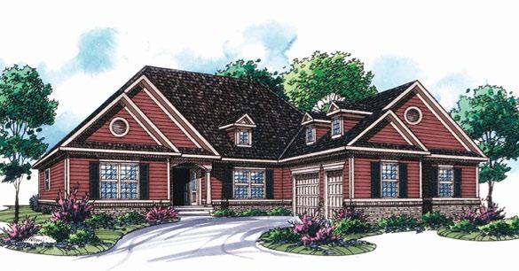
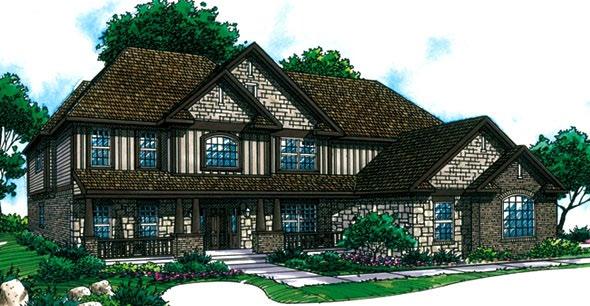
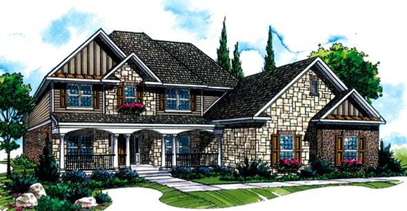
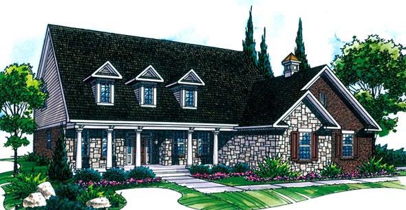


8 1.09 Illustrative Elevations 8 City of Fishers PUD District Ordinance
9 GRANITE RIDGE 1.10 Church Property and Wendel Property Wendel Property Church Property WENDEL PROPERTY A part of the Southwest quarter of Section 28, Township 18 North, Range 5 East, in Fall Creek Township, Hamilton County, Indiana more particularly described as follows: Commencing at the Southwest corner of said Southwest quarter; thence North 00 degrees 16 minutes 12 seconds West feet to the northerly Right of Way line of 126th Street per Instrument Number as recorded in the Office of the Recorder of Hamilton County, Indiana also being the POINT OF BEGINNING of this description; thence North 00 degrees 01 minutes 32 seconds East feet to the southerly boundary of Ridgefield a subdivision in Hamilton County, Indiana, the plat of which is recorded as Instrument Number , Plat Cabinet 3, Slide 107 in the Office of the Recorder, Hamilton County, Indiana; thence along the southerly boundary of said Ridgefield by the next three (3) courses: 1) North 89 degrees 30 minutes 34 seconds East feet; 2) North 00 degrees 15 minutes 13 seconds West 1, feet; 3) North 89 degrees 34 minutes 29 seconds East 1, feet to the centerline of Sand Creek; thence along the centerline of said Sand Creek by the next eight (8) courses: 1) South 38 degrees 11 minutes 40 seconds West feet; 2) South 49 degrees 38 minutes 45 seconds West feet; 3) South 30 degrees 40 minutes 38 seconds West feet; 4) South 04 degrees 39 minutes 25 seconds West feet; 5) South 22 degrees 08 minutes 50 seconds West feet; 6) South 19 degrees 18 minutes 37 seconds West feet; 7) South 04 degrees 53 minutes 07 seconds West feet; 8) South 10 degrees 48 minutes 00 seconds West feet to said northerly Right of Way line; thence along said northerly Right of Way line by the next six (6) courses: 1) South 72 degrees 51 minutes 24 seconds West feet; 2) South 89 degrees 33 minutes 19 seconds West feet; 3) South 88 degrees 27 minutes 47 seconds West feet; 4) South 87 degrees 22 minutes 15 seconds West feet; 5) North 86 degrees 55 minutes 08 seconds West feet; 6) South 87 degrees 22 minutes 14 seconds West feet to the place of beginning, containing acres, more or less. CHURCH PROPERTY A part of the West Half of the Southwest Quarter of Section 28, Township 18 North, Range 5 East in Hamilton County, Indiana, more particularly described as follows: Commencing at the Northeast corner of the said Half quarter Section; thence South 00 degrees 45 minutes 47 seconds East along the East line of the said Half Quarter Section feet to the Place of Beginning; thence South 89 degrees 09 minutes 28 seconds West feet; thence South 00 degrees 45 minutes 47 seconds East parallel with the East line of the said Half Quarter Section feet to the Northwesterly corner of land conveyed to the State of Indiana by deed recorded February 25, City of Fishers PUD District Ordinance 1986 as Instrument Number in Deed Record 201, page 269 in the Office of the Recorder of Hamilton County, Indiana,9 which Northwesterly corner of said land lies on a curve having a radius of feet, the radius point of which bears North 07 degrees 24 minutes 10 seconds West (the next five courses are along the Northerly line of the said land); thence Northeasterly


10 A part of the West Half of the Southwest Quarter of Section 28, Township 18 North, Range 5 East in Hamilton County, Indiana, more particularly described as follows: Commencing at the Northeast corner of the said Half quarter Section; thence South 00 degrees 45 minutes 47 seconds East along the East line of the said Half Quarter Section feet to the Place of Beginning; thence South 89 degrees 09 minutes 28 seconds West feet; thence South 00 degrees 45 minutes 47 seconds East parallel with the East line of the said Half Quarter Section feet to the Northwesterly corner of land conveyed to the State of Indiana by deed recorded February 25, 1986 as Instrument Number in Deed Record 201, page 269 in the Office of the Recorder of Hamilton County, Indiana, which Northwesterly corner of said land lies on a curve having a radius of feet, the radius point of which bears North 07 degrees 24 minutes 10 seconds West (the next five courses are along the Northerly line of the said land); thence Northeasterly along the said curve feet ( feet by deed) to a point which bears South 27 degrees 12 minutes 00 seconds East from the said radius point; thence North 54 degrees 02 minutes 45 seconds East feet; thence North 65 degrees 04 minutes 37 seconds East feet to a curve having a radius of feet, the radius point of which bears South 27 degrees 12 minutes 00 seconds East; thence Northeasterly along the said curve feet to a point which bears North 25 degrees 16 minutes 30 seconds West from the said radius point; thence North 35 degree 02 minutes 57 seconds East feet (29.74 feet by deed) to the apparent West right of way line of Promise Road (as existed July 1980); thence North 89 degrees 14 minutes 13 seconds East feet to the East line of the said half Quarter Section; thence North 00 degrees 45 minutes 47 seconds West along the said East line feet to the place of beginning, containing acres, more or less. GRANITE RIDGE EXCEPT: Land conveyed to Hamilton County, Indiana, by Warranty Deed recorded June 25, 1999, as Instrument # , described as follows: A part of the West half of the Southwest Quarter of Section 28, Township 18 North, Range 5 East, Hamilton County, Indiana, and begin that part of the owner s land lying within the right of way lines depicted on the Right of Way parcel Plot of Parcel 1, described as follows: Beginning feet measured ( feet Deed) South of the Northeast corner of the West half of the Southwest Quarter (the foregoing portion of this description Beginning is quoted from Deed Record 359, page 563); thence South 0 degrees 00 minutes 00 seconds West feet along the East line of said Half-Quarter Section; thence South 89 degrees 51 minutes 32 seconds West feet to the West boundary of Promise Road; thence continuing South 89 degrees 51 minutes 32 seconds West feet; thence North 2 degrees 08 minutes 49 seconds West feet to the North line of the owner s land; thence North 89 degrees 53 minutes 25 seconds East feet along said North line to the West boundary of said Promise Road; thence continuing North 89 degrees 53 minutes 25 seconds East feet along said North line to the point of beginning and containing acres, more or less. The portion of the above-described real estate which is not already embraced with public rights of way contains acres, more or less. ALSO: The entire width of right-of-way of Promise Road that is contiguous to the real estate described hereinabove. ALSO EXCEPT: A part of the West Half of the Southwest Quarter of Section 28, Township 18 North, Range 5 East, Hamilton County, Indiana, and being that part of the grantor s land lying within the right of way lines depicted on the attached Right of Way Parcel Plat, marked Exhibit B, described as follows: commencing at the southwest corner of said half-quarter section designated as point 41 on said plat; thence North 89 degrees 33 minutes 19 seconds East feet along the south line of said half-quarter section to point 232 on said plat; thence North 0 degrees 19 minutes 06 seconds West feet to the point of beginning of this description, which point of beginning is on the northern boundary of 126th Street and is designated as point 337 on said plat: thence continuing North 0 degrees 19 minutes 06 seconds West feet along the west line of the grantor s land to point 2174 on said plat; thence South 70 degrees 30 minutes 23 seconds East feet to point 1627 on said plat; thence Northeasterly feet along an arc to the left having a radius of 1, feet and subtended by a long chord having a bearing of North 78 degrees 45 minutes 27 seconds East and a length of feet to point 1634 on said plat; thence North 52 degrees 40 minutes 45 seconds East feet to point 1635 on said plat; thence North 71 degrees 26 minutes 41 seconds East feet to point 1636 on said plat; thence North 68 degrees 08 minutes 11 seconds East feet to a point on the west boundary of Promise Road designated as point 1639 on said plat; thence North 0 degrees 19 minutes 06 seconds West feet along the boundary of said Promise Road to point 2081 on said plat; thence North 6 degrees 11 minutes 02 seconds West feet to point 2080 on said plat; thence Northwesterly feet along an arc to the right having a radius of feet and subtended by a long chord having a bearing of North 6 degrees 38 minutes 56 seconds West and a length of feet to point 2079 on said plat; thence North 0 degrees 29 minutes 14 seconds West feet to point 2078 on said plat; thence North 89 degrees 30 minutes 46 seconds East feet to a point on the east line of said half-quarter section designated as point 2197 on said plat; thence South 0 degrees 19 minutes 06 seconds East fee along said east line to point 2201 on said plat; thence South 89 degrees 40 minutes 54 seconds West feet to a point of the northwestern boundary of said 126th Street designated as point 342 on said plat; thence South 35 degrees 12 minutes 20 seconds West feet along the boundary of said 126th Street to point 341 on said plat; thence along said boundary Southwesterly feet along an arc to the left having a radius of 1, feet and subtended by a long chord having a bearing of South 64 degrees 12 minutes 30 seconds West and a length of feet to point 340 on said plat; thence South 65 degrees 31 minutes 22 seconds West feet along said boundary to point 339 on said plat; thence South 54 degrees 35 minutes 50 seconds West feet along said boundary to point 338 on said plat; thence along said boundary Southwesterly feet along an arc to the right having a radius of 1, feet and subtended by a long chord having a bearing of South 73 degrees 06 minutes 49 seconds West and a length of feet to the point of beginning and containing acres, more or less, inclusive of the presently existing right of way of Promise Road which contains acre, more or less, for a net additional taking of acres, more or less. 10 City of Fishers PUD District Ordinance
116TH STREET AND BROOKS SCHOOL ROAD ORDINANCE NO B
 116TH STREET AND BROOKS SCHOOL ROAD ORDINANCE NO. 031802B A Text Amendment to Ordinance No. 071000A - An Ordinance Establishing the 116th Street and Brooks School Road Planned Unit Development District
Table of Contents City of Shelbyville Unified Development Ordinance
 City of Shelbyville Unified Development Ordinance 2012, Bradley E. Johnson, AICP Table of Contents 1: Ordinance Foundation 1.01 Title... 1-2 1.02 Unified Development Ordinance... 1-2 1.03 Defined Words...
ORDINANCE NO CITY OF MONTICELLO ADOPTING TAX INCREMENT FINANCING TAX INCREMENT FINANCING DISTRICT II
 ORDINANCE NO. 2006-59 CITY OF MONTICELLO ADOPTING TAX INCREMENT FINANCING TAX INCREMENT FINANCING DISTRICT II WHEREAS, the City of Monticello, Illinois, desires to adopt tax increment financing pursuant
DANE COUNTY ORDINANCE AMENDMENT NO: Internal Tracking Number: RECU25760
 DANE COUNTY ORDINANCE AMENDMENT NO: 10246 Internal Tracking Number: RECU25760 Amending Section 10.03 relating to Zoning Districts in the Town of Vienna. The Dane County Board of Supervisors does ordain
ORDINANCE NO. SB-3131
 ORDINANCE NO. SB-3131 AN ORDINANCE MAKING FINDINGS AND ESTABLISHING A STAR BOND PROJECT DISTRICT WITHIN THE CITY OF OVERLAND PARK, KANSAS PURSUANT TO K.S.A. 12-17,160 ET SEQ., AS AMENDED (BLUHAWK STAR
ORDINANCE NO AMENDMENT TO THE CITATION ESTATES MPD DEVELOPMENT AGREEMENT
 ORDINANCE NO. 2015- AMENDMENT TO THE CITATION ESTATES MPD DEVELOPMENT AGREEMENT AN ORDINANCE OF THE CITY COUNCIL OF THE CITY OF PALM COAST, FLORIDA, PROVIDING FOR THE SECOND AMENDED AND RESTATED MASTER
SEWER CONNECTION FEES
 100.01 Connection Fees Required 100.04 Establishment of Sewer Districts 100.02 East Sanitary Sewer District 100.05 East Southside Drive Sewer Connection District 100.03 West Sanitary Sewer District 100.01
COUNCIL COMMUNICATION
 Meeting Date: March 20, 2018 COUNCIL COMMUNICATION Agenda Item: Agenda Location: Action Items Work Plan # Legal Review: 1 st Reading 2 nd Reading Subject: A resolution approving the final design for the
ORDINANCE NO AN ORDINANCE MAKING CERTAIN FINDINGS AND ESTABLISHING THE MALL REDEVELOPMENT DISTRICT
 Introduced: January 20, 2015 Passed: January 20, 2015 Published: January 23, 2015 ORDINANCE NO. 2015-2 AN ORDINANCE MAKING CERTAIN FINDINGS AND ESTABLISHING THE MALL REDEVELOPMENT DISTRICT WHEREAS, K.S.A.
QUIT-CLAIM DEED. STONE CLIFF, LC, a Utah limited liability company, and TRAVELLER/STONE CLIFF,
 Recorded at Request of: Stone Cliff Owners Association c/o John D. Richards III Richards Kimble & Winn, PC 2040 E. Murray-Holladay Rd., Suite 102 Salt Lake City, UT 84117 Mail tax notice to: Stone Cliff
Planning & Zoning Commission
 Preliminary Plat Westwood, Section 3 Planning & Zoning Commission Planning & Development Department March 21, 2016 Request Subdivide approximately 38.1 acres of previously unplatted property to create
Village of Bedford Park ) ) SS County of Cook ) REVISED NOTICE TO SOLICIT PROPOSALS
 ) SS County of Cook ) REVISED NOTICE TO SOLICIT PROPOSALS") Village of Bedford Park ) ) SS County of Cook ) REVISED NOTICE TO SOLICIT PROPOSALS Notice is hereby given the Village of Bedford Park, Cook County, Illinois is soliciting proposals for the sale of real
Village of Bedford Park ) ) SS County of Cook ) REVISED NOTICE TO SOLICIT PROPOSALS Notice is hereby given the Village of Bedford Park, Cook County, Illinois is soliciting proposals for the sale of real
ORDINANCE NO E AN ORDINANCE OF THE COMMON COUNCIL OF THE CITY OF FISHERS, INDIANA, ADDING OPERATION OF MOTORVEHICLES AND BICYCLES IN
 ORDINANCE NO. 052118E AN ORDINANCE OF THE COMMON COUNCIL OF THE CITY OF FISHERS, INDIANA, ADDING 71.40 OPERATION OF MOTORVEHICLES AND BICYCLES IN ROADWAYS, MULTI-USE PATHS, SIDEWALKS, AND BICYCLE LANES,
ORDINANCE NO WHEREAS, An Eighty (80) foot portion of Sheffield Avenue lies between the
 foot portion of Sheffield Avenue lies between the") SPONSOR: Councilman Mark Kalwinski 1 st District Councilman PETITIONED BY: Hammond Port Authority ORDINANCE NO. 9284 AN ORDINANCE VACATING AN EIGHTY (80) FOOT PORTION OF SHEFFIELD AVENUE LYING BETWEEN
SPONSOR: Councilman Mark Kalwinski 1 st District Councilman PETITIONED BY: Hammond Port Authority ORDINANCE NO. 9284 AN ORDINANCE VACATING AN EIGHTY (80) FOOT PORTION OF SHEFFIELD AVENUE LYING BETWEEN
RESOLUTION OF ADVISABILITY AND AUTHORIZATION NO. 7841
 1 2 3 4 5 6 7 8 9 10 11 12 13 14 15 16 17 18 19 20 21 22 23 24 25 26 27 28 29 30 31 32 33 34 35 (Published in the Topeka Metro News August 9, 2006) RESOLUTION OF ADVISABILITY AND AUTHORIZATION NO. 7841
CHAPTER House Bill No. 1495
 CHAPTER 2000-419 House Bill No. 1495 An act relating to Acme Improvement District, Palm Beach County; amending chapter 28557, Laws of Florida, 1953, as amended; expanding the boundaries of said district,
CHAPTER House Bill No. 1311
 CHAPTER 2017-216 House Bill No. 1311 An act relating to the Lehigh Acres Municipal Services Improvement District, Lee and Hendry Counties; amending chapter 2015-202, Laws of Florida; expanding the territorial
CHAPTER House Bill No. 1509
 CHAPTER 2006-358 House Bill No. 1509 An act relating to Flagler Estates Road and Water Control District, St. Johns County; amending chapter 98-529, Laws of Florida; providing additional powers of the district
CHAPTER House Bill No. 1213
 CHAPTER 2015-198 House Bill No. 1213 An act relating to the West Palm Beach Water Catchment Area, Palm Beach County; amending chapter 67-2169, Laws of Florida, as amended; revising boundaries; providing
September 18, Mr. Matthew Morris Kolter Acquisitions, LLC 6981 Professional Parkway E. Sarasota, Florida Dear Mr.
 JIM C. STUDIALE Director Community Development Department September 18, 2014 Mr. Matthew Morris Kolter Acquisitions, LLC 6981 Professional Parkway E. Sarasota, Florida 34240 RE: Minor Modification of PUD
City of East Moline Committee of the Whole
 City of East Moline Committee of the Whole City Council Chambers 915 16 th Avenue East Moline, IL 61244 DATE: Monday, May 5 th, 2014 TIME: Immediately Following the Regular Council Meeting 1 Enterprise
City of Chicago O Office of the City Clerk. Document Tracking Sheet
 City of Chicago Office of the City Clerk O2019-2185 Document Tracking Sheet Meeting Date: Sponsor(s): Type: Title: Committee(s) Assignment: 3/13/2019 Emanuel (Mayor) Ordinance Adoption of Tax Increment
when the following proceedings, among others were held and done, to-wit:
 STATE OF COLORADO ) COUNTY OF ADAMS ) At a regular meeting of the Board of County Commissioners for Adams County, Colorado, held at the Administration Building in Brighton, Colorado on the 22 nd day of
ORDINANCE NO
 ORDINANCE NO. 2008-0390 AN ORDINANCE OF THE CITY OF NEWCASTLE, WASHINGTON, DECLARING PUBLIC USE AND NECESSITY RELATED TO REAL PROPERTY TO BE CONDEMNED AS REQUIRED FOR A MUNICIPAL PROJECT KNOWN AS THE NEWCASTLE
SPECIAL USE PERMIT - SUP Metcalf Avenue
 NOTICE OF PUBLIC HEARING CITY PLANNING COMMISSION CITY OF OVERLAND PARK, KANSAS Notice is hereby given that the City Planning Commission of Overland Park, Kansas, will hold a public hearing Monday, March
FENCE PERMIT APPLICATION
 OFFICE USE ONLY FENCE PERMIT APPLICATION PROCESS & REVIEW FEES $15 (GL#310) Cash or Check Only Approved Denied 110 S. MAIN STREET SPRINGVILLE, UT 84663 801.491.7861 www.springville.org Reviewed by: Print
FIRST AMENDMENT TO METRO NORTH CROSSING TAX INCREMENT FINANCING PLAN
 FIRST AMENDMENT TO METRO NORTH CROSSING TAX INCREMENT FINANCING PLAN KANSAS CITY, MISSOURI TIF COMMISSION APPROVAL: 12/13/17 12-2-17 DATE RESOLUTION NO. CITY COUNCIL APPROVAL: 2/1/18 180020 DATE ORDINANCE
BEFORE THE BOARD OF COUNTY COMMISSIONERS FOR THE COUNTY OF TILLAMOOK IN THE STATE OF OREGON ) )
 )") COUN1Y COOID'JOlJIINAI_ AFTER RECORDING RETURN TO AND SEND ALL TAX STATEMENTS TO: Tillamook County 201 Laurel Avenue Tillamook, OR 97141 Tillamook County, Oreqon 2014 002077 051091201408:17:08AM - DEED-ORDER
COUN1Y COOID'JOlJIINAI_ AFTER RECORDING RETURN TO AND SEND ALL TAX STATEMENTS TO: Tillamook County 201 Laurel Avenue Tillamook, OR 97141 Tillamook County, Oreqon 2014 002077 051091201408:17:08AM - DEED-ORDER
REAR YARDS - There shall be a rear yard no less than forty (40) feet.
 feet.") ARTICLE VII - RESIDENCE R-2 DISTRICT 700-PURPOSE - The purpose of the R-2 District is to permit the establishment of medium density one and two family dwellings. 701-PERMITTED USES - After obtaining a
ARTICLE VII - RESIDENCE R-2 DISTRICT 700-PURPOSE - The purpose of the R-2 District is to permit the establishment of medium density one and two family dwellings. 701-PERMITTED USES - After obtaining a
Arthrex, Inc Creekside Boulevard Naples FL Creekside Commerce Park CPUD
 Arthrex, Inc. 1370 Creekside Boulevard Naples FL 34108 239.403.6804 dgenson@barroncollier.com 27 48S 25E Please see Exhibit 2 Please see Exhibit 3 X X Please see Exhibit 5 Exhibit 2 Legal Description
More Restrictive Provisions of LDC to Apply
 APPENDIX E Section E101 Purpose and Intent A Parcel Specific Future Land Use with conditions (PSLUC) may be established as the result of a comprehensive plan amendment, which has been reviewed and adopted
BOARD OF ALDERMEN AGENDA
 NOTICE OF MEETING CITY OF BRANSON BOARD OF ALDERMEN Special Meeting Thursday, March 10, 2016 5:00 p.m. Council Chambers Branson City Hall 110 W. Maddux Meeting Called to Order Roll Call AGENDA REGULAR:
ORDINANCE NO. XX-2016 N. S.
 ORDINANCE NO. XX-2016 N. S. AN ORDINANCE OF THE TOWN COUNCIL OF THE TOWN OF TIBURON AMENDING MUNICIPAL CODE TITLE IV, CHAPTER 16 (ZONING) REGARDING SETBACKS, YARDS AND MISCELLANEOUS RELATED AMENDMENTS
ORDINANCE NO. ASMT-3189
 ORDINANCE NO. ASMT-3189 AN ORDINANCE LEVYING ASSESSMENTS ON LOTS, PIECES AND PARCELS OF GROUND FOR THE PURPOSE OF PAYING THE COST FOR THE CONSTRUCTION OF A FLOOD CONTROL PROJECT ALONG NEGRO CREEK BETWEEN
Starting Bid: $15,000
 Starting Bid: $15,000 Parcel # 12.00593.00 Garage Legal Description Information Lot-005 Block-006 FOREST EDGE ADDITION Eckles Township 20 147 34 Forfeited: 06-222018 Deeded acres: 1.33 Appraised Value
EXHIBIT A LEGAL DESCRIPTION OF AVIGATION EASEMENT Being that certain real property situate in the unincorporated area of the County of Monterey, State
 EXHIBIT A LEGAL DESCRIPTION OF AVIGATION EASEMENT Being that certain real property situate in the unincorporated area of the County of Monterey, State of California, described as follows: Being a portion
All of Lot 5, Except the North 783 feet, Wolf Creek Acres, a subdivision of land in the City of Overland Park, Johnson County, Kansas.
 NOTICE OF PUBLIC HEARING CITY PLANNING COMMISSION CITY OF OVERLAND PARK, KANSAS Notice is hereby given that the City Planning Commission of Overland Park, Kansas, will hold a public hearing Monday, January
CITY OF GAYLORD RESOLUTION NUMBER TOWN OF DRYDEN SIBLEY COUNTY, MINNESOTA CITY OF GAYLORD SIBLEY COUNTY, MINNESOTA
 CTY OF GAYLORD RESOLUTON NUMBER TOWN OF DRYDEN SBLEY COUNTY, MNNESOTA CTY OF GAYLORD SBLEY COUNTY, MNNESOTA N THE MATTER OF THE ORDERLY ANNEXATON BETWEEN THE CTY OF GAYLORD DRYDEN TOWNSHP PURSUANT TO MNNESOTA
WARRANTY DEED (Maine Statutory Short Form) KNOW ALL PERSONS BY THESE PRESENTS, that Winslow H. Pillsbury, of the Town of
 KNOW ALL PERSONS BY THESE PRESENTS, that Winslow H. Pillsbury, of the Town of") WARRANTY DEED (Maine Statutory Short Form) KNOW ALL PERSONS BY THESE PRESENTS, that Winslow H. Pillsbury, of the Town of Cape Elizabeth, County of Cumberland and State of Maine, for consideration paid,
WARRANTY DEED (Maine Statutory Short Form) KNOW ALL PERSONS BY THESE PRESENTS, that Winslow H. Pillsbury, of the Town of Cape Elizabeth, County of Cumberland and State of Maine, for consideration paid,
ORDINANCE NO AMENDMENT TO ORDINANCE NO NASSAU COUNTY, norida. WHEREAS, on the 28th day of January, 1991, the Board of County
 ORDINANCE NO. 99-23 AMENDMENT TO ORDINANCE NO. 91-04 NASSAU COUNTY, norida WHEREAS, on the 28th day of January, 1991, the Board of County Commissioners, Nassau County, Florida (the "Board"), did adopt
1/9/2018. City Council City Hall Wilmington, North Carolina Dear Mayor and Councilmembers:
 ITEM O2 OFFICE OF THE CITY MANAGER (910) 341-7810 FAX (910)341-5839 TDD (910)341-7873 1/9/2018 City Council City Hall Wilmington, North Carolina 28401 Dear Mayor and Councilmembers: On March 21, 2017,
MAPPING DESCRIPTIONS AND DRAFTING PARCEL BOUNDARIES FOR CADASTRAL MAPPING
 MAPPING DESCRIPTIONS AND DRAFTING PARCEL BOUNDARIES FOR CADASTRAL MAPPING Chapter 6 2015 Cadastral Mapping Manual 6-0 Another method of describing land, aside from the fractional section method, is called
MEMORANDUM OF LEASE RECITALS
 MEMORANDUM OF LEASE THE STATE OF TEXAS COUNTY OF HARRIS THIS MEMORANDUM OF LEASE (this "Memorandum") is made and entered into effective as of the 17th day of May, 2001, by and between HARRIS COUNTY SPORTS
EXHIBIT A BOUNDARY RIDGE PROPERTY
 EXHIBIT A BOUNDARY RIDGE PROPERTY Legal Description: A tract of land situated in Government Lots 1 and 2, Section 10 and Government Lots 1 and 2, Section 11, Township 40 North, Range 1 West of the Willamette
ORDINANCE NO AN ORDINANCE OF THE CITY OF FOLSOM AMENDING CHAPTER OF THE FOLSOM MUNICIPAL CODE CONCERNING SWIMMING POOLS, SPAS AND HOT TUBS
 ORDINANCE NO. 1267 AN ORDINANCE OF THE CITY OF FOLSOM AMENDING CHAPTER 14.28 OF THE FOLSOM MUNICIPAL CODE CONCERNING SWIMMING POOLS, SPAS AND HOT TUBS THE CITY COUNCIL OF THE CITY OF FOLSOM HEREBY DOES
ORDINANCE ORDINANCE ANNEXING PROPERTY TSM GREENBRIER LLC
 ORDINANCE 2018-7 ORDINANCE ANNEXING PROPERTY TSM GREENBRIER LLC RECITALS WHEREAS, the City ofbuffalo has received a Petition for Annexation by Ordinance from TSM Greenbrier LLC for the annexation of97
EXHIBIT A LEGAL DESCRIPTION OF PROPERTY TO BE INCLUDED IN THE DISTRICT
 - - - - EXHIBIT A LEGAL DESCRIPTION OF PROPERTY TO BE INCLUDED IN THE DISTRICT COMMUNITY FACILITIES DISTRICT FOR QUAILWOOD AND ROUWENHORST LEGAL DESCRIPTION JULY 28, 2004 A PORTION OF LAND LYING WITHIN
City Council Meeting 8. B. Meeting Date: 09/08/2015. Agenda Category: New Business. Subject: Establishment of a STAR Bond Project District
 City Council Meeting 8. B. Meeting Date: 09/08/2015 Submitted By: Kathy Sexton, City Manager Agenda Category: New Business Subject: Establishment of a STAR Bond Project District Guests: Korb Maxwell, Attorney,
November 13, Planning and Land Development Regulation Commission (PLDRC)
") 1 of 29 GROWTH AND RESOURCE MANAGEMENT DEPARTMENT PLANNING AND DEVELOPMENT SERVICES DIVISION CURRENT PLANNING ACTIVITY 123 W. Indiana Avenue, DeLand, FL 32720 (386) 943-7059 PUBLIC HEARING: CASE NO: SUBJECT:
1 of 29 GROWTH AND RESOURCE MANAGEMENT DEPARTMENT PLANNING AND DEVELOPMENT SERVICES DIVISION CURRENT PLANNING ACTIVITY 123 W. Indiana Avenue, DeLand, FL 32720 (386) 943-7059 PUBLIC HEARING: CASE NO: SUBJECT:
ST. TAMMANY PARISH COUNCIL ORDINANCE
 ST. TAMMANY PARISH COUNCIL ORDINANCE ORDINANCE CALENDAR NO: 4748 COUNCIL SPONSOR: GOULD/BRISTER INTRODUCED BY: MR. STEFANCIK ORDINANCE COUNCIL SERIES NO: PROVIDED BY: PLANNING SECONDED BY: MR. ARTIGUE
Roadway Classification Design Standards and Policies. Pueblo, Colorado November, 2004
 Roadway Classification Design Standards and Policies Pueblo, Colorado November, 2004 Table of Contents Page Chapter 1. General Provisions 1.1 Jurisdiction 3 1.2 Purpose and Intent 3 1.3 Modification 3
Site Location Map and 4424 Excelsior Boulevard, and 3743 Monterey Drive
 Site Location Map 4400 and 4424 Excelsior Boulevard, and 3743 Monterey Drive www.bkvgroup.com EXCELSIOR AND MONTEREY DRIVE 10/20/2015 www.bkvgroup.com EXCELSIOR AND MONTEREY DRIVE 10/20/2015 SHEET 2 OF
Enclosed please find an executed and notarized Certificate of Completion regarding North Center Senior Housing at 2324 West Irving Park Road.
 May 14,2008 City of Chicago Richard M. Daley, Mayor Department of Planning and Developme.nt Arnold L. Randall Commissioner City Hall, Room 1000 121 North LaSalle Street Chicago, Illinois 60602 312 744-4190
4.7 Landscape Provisions.
 4.7. A. Intent. Landscaping of required Yards and required Bufferyards is an essential element of the design of a site with respect to promoting the public health, safety, comfort, convenience and general
RECOMMENDED MOTION: I MOVE TO PASS SECOND READING AND ADOPT ORDINANCE 556, TO REMOVE NE 173RD STREET FROM THE DESIGNATED PEDESTRIAN-ORIENTED STREETS.
 CITY OF WOODINVILLE, WA REPORT TO THE CITY COUNCIL 17301 133rd Avenue NE, Woodinville, WA 98072 wvvw.ci.woodinville.wa.us To: Honorable City Council Date: 02/05/2013 From: Richard A. Leahy, City Manager
NOTICES OF SHERIFF'S SALE
 Updated: 05/03/18 at 1:27 AM NOTICES OF SHERIFF'S SALE Date & Time of Sale: Thu, Jun 14, 2018 at 10:00 am Sheriff Sale File number: 42-18-0030-SS Judgment to be Satisfied: $1,860,456.55 Cause Number: 42D01-1710-MF-000051
ORDINANCE NO. WHEREAS, Downtown Bellingham and the Fairhaven commercial core are places where people come to play, work, shop, and live;
 ORDINANCE NO. AN ORDINANCE OF THE CITY OF BELLINGHAM, WASHINGTON AMENDING BELLINGHAM MUNICIPAL CODE PROVISIONS 10.24.070, 11.48.140, 11.52.010, EXTENDING THE HOURS OF RESTRICTION FOR SITTING AND LYING
VOLUME I OF II HARRIS RANCH SPECIFIC PLAN 2007 (AMENDMENT 6.1, ORDINANCE 11-13)
") VOLUME I OF II HARRIS RANCH SPECIFIC PLAN 2007 (AMENDMENT 6.1, ORDINANCE 11-13) OWNER ACKNOWLEDGMENTS DEVELOPMENT MANAGER LEGAL In Loving memory of Dallas Harris By George we can do it if we work hard
VOLUME I OF II HARRIS RANCH SPECIFIC PLAN 2007 (AMENDMENT 6.1, ORDINANCE 11-13) OWNER ACKNOWLEDGMENTS DEVELOPMENT MANAGER LEGAL In Loving memory of Dallas Harris By George we can do it if we work hard
M I N U T E S OKLAHOMA COUNTY PLANNING COMMISSION
 M I N U T E S OKLAHOMA COUNTY PLANNING COMMISSION September 21, 2000 1:30 P.M. The meeting of the Oklahoma County Planning Commission convened and was called to order by Ms. Cheryl Dorrance, at 1:30 P.M.,
A G E N D A OKLAHOMA COUNTY PLANNING COMMISSION. November 16, Approval of Minutes of the Previous Meeting: (October 19, 2006)
") A G E N D A OKLAHOMA COUNTY PLANNING COMMISSION ROOM 103 1:30 p.m. November 16, 2006 1. Notice of meeting posted November 9, 2006. 2. Call to Order. 3. Roll Call. 4. Approval of Minutes of the Previous
A G E N D A OKLAHOMA COUNTY PLANNING COMMISSION ROOM 103 1:30 p.m. November 16, 2006 1. Notice of meeting posted November 9, 2006. 2. Call to Order. 3. Roll Call. 4. Approval of Minutes of the Previous
Zoning District Minimum Minimum MINIMUM SETBACKS Maximum Maximum % Lot Area Lot Width Front Yard Rear Yard Side Yard Corner Lot (street side yard)
") GR (General Rural) R1-43 (Conventional Single Family 1-1/4 gross acres; lots recorded prior to 11/18/74 are okay as is. 1-1/4 gross acres in areas with FPEs; 1 acre in areas w/o FPEs. 100 ft.; lots recorded
GR (General Rural) R1-43 (Conventional Single Family 1-1/4 gross acres; lots recorded prior to 11/18/74 are okay as is. 1-1/4 gross acres in areas with FPEs; 1 acre in areas w/o FPEs. 100 ft.; lots recorded
CHAPTER House Bill No. 655
 CHAPTER 2016-248 House Bill No. 655 An act relating to the City of Jacksonville, Duval County; amending chapter 87-471, Laws of Florida, as amended; establishing special zones in downtown Jacksonville;
CITY OF BONITA SPRINGS ZONING ORDINANCE NO
 CITY OF BONITA SPRINGS ZONING ORDINANCE NO. 05-07 A ZONING ORDINANCE OF THE CITY OF BONITA SPRINGS, FLORIDA; APPROVING A REQUEST BY BONITA FAIRWAYS RPD/MHPD TO AMEND THE MASTER CONCEPT PLAN TO DESIGNATE
CITY OF ZUMBROTA ORDINANCE NO
 CTY OF ZUMBROTA ORDNANCE NO 272 AN ORDNANCE OF THE CTY OF ZUMBROTA MNNESOTA ANNEXNG LAND LOCATED N ZUMBROTA TOWNSlllP GOODHUE COUNTY MNNESOTA PURSUANT TO MNNESOTA STATUTES 4433 SUBDVSON 2(3) PERMTTNG ANNEXATON
MAJOR THOROUGHFARE PLAN
 MAJOR THOROUGHFARE PLAN Adopted by City Commission On November 21, 2005 Per Resolution No. 4420 Amendment to the Comprehensive Community Development Plan City of Hobbs City of Hobbs MAJOR THOROUGHFARE
ARTICLE V - AGRICULTURAL SUBURBAN ESTATE RESIDENTIAL - A- SER
 Adopted August 23, 2010 ARTICLE V - AGRICULTURAL SUBURBAN ESTATE RESIDENTIAL - A- SER 500-PURPOSE - The purpose of the A-SER District is: 1) to preserve and protect the decreasing supply of prime agricultural
SWIMMING POOL BUILDING PERMIT REQUIREMENTS FOR THE UNINCORPORATED TERRITORY OF DOUGLAS COUNTY, KANSAS
 SWIMMING POOL BUILDING PERMIT REQUIREMENTS FOR THE UNINCORPORATED TERRITORY OF DOUGLAS COUNTY, KANSAS ALL CONSTRUCTION SHALL BE BUILT IN ACCORDANCE WITH STANDARDS SET FORTH IN THE 2012 International Code
PRELIMINARY POINT OF BEGINNING SEE DETAIL "A" ESCONDIDO PIPELINE MATCHLINE 30' P.R.W.E.
 MATCHLINE POINT OF BEGINNING SEE DETAIL "A" Notes: 1. This plat was prepared without the benefit of a current Title Report. All deeds were provided by the client and may not reflect current ownership.
CHAPTER 13 DESIGNATING LEGAL BOUNDARIES ARTICLE 4 - AGRICULTURAL DISTRICTS
 CHAPTER 13 DESIGNATING LEGAL BOUNDARIES ARTICLE 4 - AGRICULTURAL DISTRICTS SECTIONS: Sections 13-4-101 to 108, inclusive. Agricultural District "A" - general provisions. Section 13-4-101. Legal boundary
Single Family Detached District Summary of Allowable Uses
 Single Family Detached District Summary of Allowable Uses (Please refer to Section 18-160 for the most up-to-date list: Section 18-160) Accessory Uses Accessory community center private (SUP) Accessory
Downum Title Services, Inc. TITLE REPORT Work Order #6581
 17030 Main Street South Blountstown, Florida 32424 Downum Title Services, Inc. JUDY DOWNUM Telephone: (850) 674-3533 Fax: (850) 674-1343 TITLE REPORT Work Order #6581 FOR GULF COUNTY TAX COLLECTOR 1000
AGENDA BILL. Beaverton City Council Beaverton, Oregon FOR AGENDA OF: ~1-8 BILL NO: BUDGET IMPACT
 AGENDA BILL SUBJECT: An Ordinance Withdrawing Territory From The Tualatin Valley Water District and Declaring An Emergency Beaverton City Council Beaverton, Oregon 3-27-18 FOR AGENDA OF: ~1-8 BILL NO:
FEASIBILITY REPORT STORM DRAINAGE IMPROVEMENTS TERRACE AND METCALF CITY OF OVERLAND PARK JOHNSON COUNTY, KANSAS
 March 2, 2011 FEASIBILITY REPORT STORM DRAINAGE IMPROVEMENTS STANLEY STORM DRAINAGE IMPROVEMENTS, 151sT TERRACE AND METCALF CITY OF OVERLAND PARK JOHNSON COUNTY, KANSAS DESCRIPTION: This report relates
S U B S T I T U T E O R D I N A N C E. WHEREAS, The City of Chicago has encouraged transit-oriented development since 2013; and
 S U B S T I T U T E O R D I N A N C E WHEREAS, The City of Chicago has encouraged transit-oriented development since 2013; and WHEREAS, Encouraging development around Chicago s transit assets both promotes
Midway City Council 15 January 2019 Regular Meeting. Homestead Villas / Preliminary Approval
 Midway City Council 15 January 2019 Regular Meeting Homestead Villas / Preliminary Approval CITY COUNCIL MEETING STAFF REPORT DATE OF MEETING: January 15, 2018 NAME OF PROJECT: NAME OF APPLICANT: AGENDA
in the manner and way provided by law and the rules and
 IN THE STATE OIL AND GAS BOARD OF MISSISSIPPI RE: PETITION OF OXY USA INC. TO AMEND THE ' ' ial FIELD RULES FOR N0RTH MUD CR EK amp c iqqi FIELD, WILKINSON COUNTY, MISSISSIPPI "" ' DOCKET NO. 205-^1-74?
BELLALAGO CLUB MEMBERSHIP FEE SCHEDULE
 THIS INSTRUMENT PREPARED BY: DENNIS J. GETMAN, ESQ. Avatar Properties Inc. 201 Alhambra Circle, 12 th Floor Coral Gables, Florida 33134 LARRY WHALEY OSCEOLA COUNTY, FLORIDA CLERK OF CIRCUIT COURT DLB Date
ORDINANCE NO. WHEREAS, the city council finds that it is in the public interest to amend Article 521 as
 Page 160135 1-13-16 ORDINANCE NO. 29989 An ordinance amending Article 521, PD 521, of Chapter 51P, Dallas Development Code: Planned Development District Regulations, of the Dallas City Code; amending the
NOTICE OF PUBLIC HEARING
 NOTICE OF PUBLIC HEARING Notice is hereby given that the first and second public hearing of a proposed annexation area described below will be held by the City Council of the City of Rockport, Texas, at
Article 1 Administration and Enforcement Article 2 Zoning Districts and Map
 CITY OF RICHMOND ZONING ORDINANCE TABLE OF CONTENTS Article 1 Administration and Enforcement... 1-1 Sec. 1.01 Intent and Purpose...1-1 Sec. 1.02 Scope...1-1 Sec. 1.03 Short Title...1-1 Sec. 1.04 Enabling
IN THE CIRCUIT COURT OF THE STATE OF OREGON FOR THE COUNTY OF MARION Civil Department ) ) ) ) ) ) ) ) ) ) ) ) ) ) ) ) )
 ) ) ) ) ) ) ) ) ) ) ) ) ) ) ) )") 1 2 3 4 5 6 IN THE CIRCUIT COURT OF THE STATE OF OREGON FOR THE COUNTY OF MARION Civil Department 7 8 9 10 11 12 13 14 15 CREEKSIDE HOMEOWNERS ASSOCIATION, INC., an Oregon non-profit corporation, v. Plaintiff,
1 2 3 4 5 6 IN THE CIRCUIT COURT OF THE STATE OF OREGON FOR THE COUNTY OF MARION Civil Department 7 8 9 10 11 12 13 14 15 CREEKSIDE HOMEOWNERS ASSOCIATION, INC., an Oregon non-profit corporation, v. Plaintiff,
REMOVE BARRIERS TO, ENCOURAGE CREATION OF AND PROVIDE GUIDELINES FOR SAFE ROUTES (ALL DISTRICTS)
") Ordinance 2009-98 AN ORDINANCE OF THE BOARD OF SUPERVISORS OF PIMA COUNTY, ARIZONA; RELATING TO ZONING; AMENDING THE PIMA COUNTY ZONING CODE TITLE 18 BY AMENDING SECTION 18.03.020 (DEFINITIONS) TO ADD
Ordinance 2009-98 AN ORDINANCE OF THE BOARD OF SUPERVISORS OF PIMA COUNTY, ARIZONA; RELATING TO ZONING; AMENDING THE PIMA COUNTY ZONING CODE TITLE 18 BY AMENDING SECTION 18.03.020 (DEFINITIONS) TO ADD
2018 REAL PROPERTY TAX FORECLOSURE ROLL
 ACCOUNT NUMBER: 032301-3-023-1004 TAXPAYER NAME: HARTSTROM GRETA F ET AL LEGAL DESCRIPTION: Section 03 Township 23 Range 1W THE SOUTH HALF OF THE NORTH HALF OF THE SOUTH HALF OF THE SOUTHEAST QUARTER OF
Town of Holly Springs Town Council Meeting Agenda Cover Sheet
 Town Council Meeting Agenda Cover Sheet Meeting Date: Jan. 15, 2019 Agenda Item #: 7b Agenda Placement: Public Hearing (Recognitions (awards, proclamations), Requests & Communications (reports, information
PUBLIC NOTICE: TO ALL CONCERNED CITIZENS OF HIALEAH GARDENS, FLORIDA. NOTICE TO BE POSTED AT CITY HALL.
 Mayor Yioset De La Cruz City Council Members Chairman Luciano Lucky García Vice Chairman Rolando Roly Piña Council member Jorge A. Merida Council member Jorge Gutierrez Council member Elmo L. Urra PUBLIC
Villages of Pasadena Hills Financial Plan UPDATED Spring 2012 DRAFT
 36 37 38 39 40 41 42 43 44 45 46 Appendix B (Unchanged from January 2009 Adoption) 47 Projects Approved Prior to VOPH Comprehensive Plan Amendment Ashley Groves Chapel Creek Chapel Hill Farmington Hills
Bradford s Landing. Preliminary Plan Abandonment AB753 & AB754 MONTGOMERY COUNTY PLANNING DEPARTMENT
 Bradford s Landing Preliminary Plan 120170060 Abandonment AB753 & AB754 1 Overview Staff recommends Approval of Preliminary Plan 120170060 with revised conditions and Adoption of the Resolution. 244 lots
PRELIMINARY DEVELOPMENT AREA A DEVELOPMENT AREA B PROPOSED ZONING - NS 1,435,131 SQUARE FEET, ACRES
 DEVELOPMENT AREA A Inte rs tate 485 PRELIMINARY PROPOSED ZONING - MX-1 1,479,033 SQUARE FEET, 33.954 ACRES MX-1 NS DEVELOPMENT AREA B PROPOSED ZONING - NS 1,435,131 SQUARE FEET, 32.946 ACRES Albe mar le
ORDINANCE NO Text Amendment Z-S-695, to allow horse boarding as an interim use on undeveloped CRzoned
 ORDINANCE NO. 1204 AN ORDINANCE OF THE CITY COUNCIL OF THE CITY OF SIMI VALLEY APPROVING A CITY-INITIATED SIMI VALLEY MUNICIPAL CODE TEXT AMENDMENT TO ALLOW THE BOARDING OF HORSES ON UNDEVELOPED LAND IN
TABLE OF CONTENTS ARTICLE I. GENERAL PROVISIONS
 TABLE OF CONTENTS ARTICLE I. GENERAL PROVISIONS Sec. 21-1100. Title... I-1 Sec. 21-1110. Authority... I-1 Sec. 21-1120. Purpose... I-1 Sec. 21-1130. Conflicts... I-1 Sec. 21-1140. Scope... I-2 Sec. 21-1150.
Swimming Pool Installation
 Swimming Pool Installation The following information is provided to assist in the planning and installation of swimming pools and hot tubs within the City of Vandalia, OH. Zoning, Fence and Electric Permits
Exhibit 1 PLANNING COMMISSION AGENDA ITEM
 Exhibit 1 PLANNING COMMISSION AGENDA ITEM Project Name: Grand Junction Circulation Plan Grand Junction Complete Streets Policy Applicant: City of Grand Junction Representative: David Thornton Address:
THIS ASSIGNMENT AND ASSUMPTION OF CONC in AGREEMENT (this
 TfflS DOCUMENT WAS PREPARED BY: Kirkland & Ellis LLP 300 North LaSalle Chicago, Illinois 60654 Attention: Andrew Small, Esq. AFTER RECORDING RETURN TO: Allen & Overy LLP 1221 Avenue of the Americas New
Non-required Fences Update
 Non-required Fences Update Quality of Life & Environment Committee January 11, 2016 Presented by the Department of Sustainable Development and Construction Purpose Follow up on the May 26, 2015, August
2200 FIFTH STREET CONTINUED PRELIMINARY DESIGN REVIEW
 D E S I G N R E V I E W C O M M I T T E E S t a f f R e p o r t CONTINUED PRELIMINARY DESIGN REVIEW For Committee Discussion/ Majority Recommendation MARCH 16, 2017 Design Review #DRCP2016-0006 of the
SECTION 8.0 HIGHWAY SETBACK LINES & ROADSIDE REGULATIONS
 SECTION 8.0 HIGHWAY SETBACK LINES & ROADSIDE REGULATIONS 8.1 Classification and Setbacks For the purpose of determining the distance buildings and other structures are set back, the roads and highways
IN THE CIRCUIT COURT OF PULASKI COUNTY, ARKANSAS FIFTH DIVISION. REGIONS BANK, an Alabama banking corporation
 IN THE CIRCUIT COURT OF PULASKI COUNTY, ARKANSAS FIFTH DIVISION REGIONS BANK, an Alabama banking corporation PLAINTIFF v. Case No. 60CV-2012-4668 ARRINGTON APTS II, LIMITED PARTNERSHIP, an Arkansas limited
NJH: Item #4.2 L. AN ORDINANCE 99689
 AN ORDINANCE 99689 AMENDING CHAPTER THIRTY FIVE of THE CITY CODE BY AMENDING SECTION 35-304, OFFICIAL ZONING MAP, OF THE CITY CODE OF SAN ANTONIO, TEXAS TO ESTABLISH NEIGHBORHOOD CONSERVATION DISTRICT
Sponsored by Mrs. Gina Gregory and Mr. Reggie Copeland.
 AN ORDINANCE REGULATION TO AMEND THE SUBDIVISION REGULATIONS FOR THE CITY OF MOBILE, ALBAMA CODES TO CREATE NEW WALKABLE STREET STANDARDS THAT ENABLES TRADITIONAL, WALKABLE VILLAGE AND NEIGHBORHOOD CENTERS
FEE SCHEDULE POOL PERMIT FEES. Refundable Security (Cash of L.C.) 1 Hot Tub, Spa, etc. $ nil 2 Above Ground Pool $ nil
 1 Hot Tub, Spa, etc. $ nil 2 Above Ground Pool $ nil") FEE SCHEDULE POOL PERMIT FEES Type of Pool Total Fee Refundable Security (Cash of L.C.) 1 Hot Tub, Spa, etc. $100.00 nil 2 Above Ground Pool $200.00 nil 3 Inground Pools (assumed $350.00 $1500.00 subdivision)
FEE SCHEDULE POOL PERMIT FEES Type of Pool Total Fee Refundable Security (Cash of L.C.) 1 Hot Tub, Spa, etc. $100.00 nil 2 Above Ground Pool $200.00 nil 3 Inground Pools (assumed $350.00 $1500.00 subdivision)