Regional Waterway Management System For North Manatee County
|
|
|
- Paul Wheeler
- 5 years ago
- Views:
Transcription

1 July, 999/Revised Jan Regional Waterway Management System For North Manatee County TD- Robert A. Swett Gustavo A. Antonini Sharon Schulte
2
3 Table of Contents Table of Contents... ii Tables... iv Figures... v Appendices... vi Acronyms... vii Acknowledgments... viii Executive Summary... ix. Background.... Information Base... a. Trafficsheds... b.... c. Facilities... d. Moorings... e. Signage... f. Site.... Field Surveys... a. Depths... b., Facilities and Signs... c. Data Editing Printed Data Products... 5 a. Trafficshed Scale Atlases... 5 b. Regional Scale Atlases Geographic Information System Data Files, Metadata and Software Application Institutional Framework for Regional Waterway Systems Management Results of the North Manatee County Project... 7 ii
4 a b. Trafficsheds... 8 c. Accessibility... 8 d. Locations with Concentrations of Restricted Access... 9 e. Channel Restrictions... 9 f. Relation of Boat Accessibility to Channel Restriction... g. Projected Dredging Requirements... h. Signage Special Management Considerations Warranted in Terra Ceia Bay Conclusions and Recommendations... a. Short-Term... b. Long-Term... References... iii
5 Tables. Distribution of and Trafficshed Types in North Manatee County by Boating Region Counts of Boat Types in North Manatee County Distribution of Boating Facilities in North Manatee County by Boating Region Distribution of Boat Types in North Manatee County by Boating Region Boat Access Levels for North Manatee County by Boating Region Number of Restricted and Levels of Access by Boat Draft Category Variable Draft Capability of Restricted in North Manatee County Variable Draft Capability by Boat Draft for Restricted In North Manatee County Channel Restrictions within North Manatee County... a. Trafficsheds and Access Channels Combined. b. Access Channels Serving Two or More Trafficsheds.. Distribution of Restricted and the Estimated Dredge for Normal Clearance in Trafficsheds with Ten or More Restricted.... Projected Dredge Requirements for : Normal Clearance Projected Dredge Requirements for : Additional Depth Clearance ( ft.) Projected Dredge Requirements for Access Channels, The Cutoff and Palma Sola Bay Entrance... 7 a. Normal Clearance. b. Additional Depth ( ft.) Clearance.. Distribution of Boating-Related Signs... 8 a. Categories of Signs by Boating Region. b. Types of Signs by Boating Region. iv
6 Figures. Distribution of North Manatee County Trafficsheds by Boating Region Distribution of North Manatee County Trafficsheds by Type.... Distribution of Major Mangrove Communities in North Manatee County.... Approximate Distribution of Sea Grass Beds in North Manatee County Locations of Tide Stations Used to Correct Depths to MLLW Example of Analysis Results Showing Restricted and Channels Top Restricted Trafficsheds in North Manatee County According to Number of Restricted Top Restricted Trafficsheds in North Manatee County and Estimated Dredge for Normal Clearance... 6 v
7 Appendices A. Restricted by Access Categories... 7 B. by Access Categories... C. Data Inventory on Trafficshed Waterway, Boat and Facility Characteristics... vi
8 Acronyms DGPS DOQQ ESRI FDEP FSG GIS ICW MLLW MOA NOAA PIN SWFWMD USACE USGS WCIND Differential Global Positioning Systems Digital Orthophoto Quarter Quadrangles Environmental Systems Research Institute, Inc. Florida Department of Environmental Protection Florida Sea Grant Geographic Information System Intracoastal Waterway Mean Lower Low Water Memorandum of Agreement National Oceanic and Atmospheric Administration Parcel Identification Number Southwest Florida Water Management District U.S. Army Corps of Engineers U.S. Geological Survey West Coast Inland Navigation District vii
9 Acknowledgments The authors wish to thank their colleagues and local staff who offered valuable assistance throughout all phases of this project. The University of Florida, Department of Coastal and Oceanographic Engineering, Robert Dean (Chair), Max Sheppard (Professor), and Sidney Schofield (Assistant Laboratory Director), provided the loan of tide-recording equipment, and assisted with the design and computer programming of the tidal correction procedures, respectively. Capt. Jonathan Davis and Larry Bearse assisted with boat operations for the field survey on the Manatee River, while Marine Patrol Officer Andy Glenn, Holmes Beach Police Department, and C.R. Whitney, Holmes Beach resident, assisted with boat operations for the Anna Maria Sound portion of the survey. Florida Sea Grant's Betty Spivey administered the project, and Susan Grantham assisted with the editing of this final report as a Sea Grant publication. Manatee County staff offered assistance in meaningful ways: Jim Englehardt (program administration), Jack Gorzeman (resource planning), Greg Blanchard (data processing), John Stevely (marine extension), and Bob Fluke (field surveying). A special note of thanks is due to Manatee County s Commissioner, Joe McClash, who also served as Chair of the West Coast Inland Navigation District (WCIND). Bob Jorgensen, Holmes Beach Canal Commission, offered local assistance and provided valued encouragement and moral support. We also wish to thank the WCIND s Executive Director, Chuck Listowski, and Information Specialist, Evan Brown, for their assistance and support. Project funding was provided by Manatee County, the West Coast Inland Navigation District, the University of Florida Sea Grant Program, and the NOAA Coastal Services Center, Charleston, S.C. viii
10 Executive Summary This Regional Waterway Management System for northern Manatee County provides the scientific base and information necessary to meet the waterway management needs of waterfront neighborhoods, extending from the Cortez bridge north to the Hillsborough County line, and including the water bodies of Palma Sola Bay, Holmes Beach, Bimini Bay, Anna Maria Sound, Manatee River (upstream to the I-75 bridge), Snead Island Cutoff, and Terra Ceia Bay. Information is presented in tables and maps on approximately 5 miles of navigable waterways,,78 boats, 7,66 moorings,,965 shore facilities, and,8 boating-related signs. The report is based on regional (:,) and large-scale (:,) mapping of water depth, boat and facility characteristics, signage, and habitat (sea grass, mangrove). The detailed analysis delineates and quantifies, at a ft resolution, levels of boat accessibility to the open bay, and the location and extent of channel depth restrictions. The methodology and objective of the North Manatee County Project stem from a Pilot Study conducted by Florida Sea Grant (FSG) and the West Coast Inland Navigation District (WCIND). The Pilot Study created the design and implemented a test application of a management system for southwest Florida waterways that is consistent with municipal, county, Florida Department of Environmental Protection (FDEP), and WCIND goals, of facilitating safe boating and reducing boating impacts on natural resources. The design criteria are: (a) fit channel maintenance to boat draft needs; (b) minimize impacts on bay habitats; (c) prioritize and evaluate management alternatives on a regional scale; and (d) identify information products, for boaters and shore residents, that encourage environmental awareness by users of neighborhood waterways and boat access channels. The waterway management needs of northern Manatee County are uniquely defined by the geography of boat source areas (trafficshed); there are waterways with many boats, and areas with few boats. The relations of concentrations of boats to access channel length, and of boat draft to controlling channel depth determine the degree of boat accessibility and channel restrictions. An understanding of these relations is fundamental to developing and implementing rational waterway management policy. The results of this study argue in favor of prioritizing channel improvements based on greatest need; they also highlight conditions within north county waters that should guide region-wide bay water use policies. The results indicate that the greatest problems of boat access and channel restrictions occur in a relatively few trafficsheds. The trafficsheds which contain the greatest numbers of restricted boats are: Sea Grape Harbor, Bimini Bay/Key Royale, ix
11 and Regatta Pointe; they account for percent of the boat access problems and 5. percent of the channel restrictions. Manatee County should concentrate initial waterway management efforts at these locations. Another eight waterways (Palma Sola Estates, Golf and Bay Estates I, Fisherman Village, Warners Bayou, Braden Castle Park/Carleton Arms, Tropic Isles, San Remo Shores, and Cuts Edge Marina) account for an additional.5 percent of the boat access problems and 9. percent of the channel restrictions. In some cases, such as Sea Grape Harbor, Regatta Pointe, Braden Castle Park/Carleton Arms, and Golf and Bay Estates I, relatively short segments of channel restrictions impede relatively large numbers of boats: the high benefit-to-cost is an incentive to make channel improvements at these locations. There are several secondary access channels, serving numerous trafficsheds, which are heavily used by boaters to gain entry to the Intracoastal Waterway and the Manatee River or Terra Ceia Bay. They are the Palma Sola Bay entrance and the Cutoff, both of which have relatively short lengths of restricted channel segments. The high volume of boat traffic traversing these arteries makes them strong candidates for maintenance dredging. A large number () of trafficsheds (6.6 percent of all boat source areas) have relatively short access channels and few boats. There are access problems at some of these locations but the low numbers of boats and channel lengths per waterway mean that the per unit channel improvement cost will be high relative to the improved access for each boat. Many of these small trafficsheds are situated on the Manatee River where channels link one or two single-family residence boat docks to the main river channel. The waterway inventory information in the project's Geographic Information System (GIS) database has value and application beyond the bay water planning and management results presented in this report. This information should be reformatted and provided to shorefront residents and boaters in the trafficsheds targeted for waterway improvements, as Waterway Maps, showing channel center-line depths, boat facilities, and natural resource conditions. (The WCIND and FSG have produced similar maps of anchorages.) This information can sensitize users to the environmental conditions of the waterways and provide a basis for instilling stewardship and responsible boating practices. Manatee County should consider implementing these recommendations under the Memorandum of Agreement (MOA) for Regional Waterway Systems Management. This MOA is designed to offer local governments and local waterfront community organizations with a mechanism to effect regional waterway improvements within an ecosystem, place-based management approach. The MOA provides an avenue for pursuing region-wide permit review and project applications. A proposal for needed maintenance dredging should be submitted to the FDEP that is county-wide in coverage and comprehensive in scope, based on the results of this Project covering north county waters, and the Sarasota Bay Pilot Study which covers south county waters. x
12 Manatee County and the WCIND have an investment in this Regional Waterway Management System. This system should be maintained and enhanced in order to respond to the county's growing needs for rapid assessment and comprehensive geographic analysis of its bay water resources. The Regional Waterway Management System can be strengthened by linking it to the county's upland databases. This will facilitate responding to more complex issues which transcend land-water boundaries, such as identifying sources of sedimentation and allocating maintenance dredging costs based on sediment-source contributors and waterway users. The Regional Waterway Management System database should be updated periodically with county-wide boat information. The WCIND has developed a preliminary plan based on revising the annual Vessel Registration Form. This plan, to incorporate information on boat type, draft and location onto the form, offers a systematic updating method which should be pursued through the County Tax Collector's Office and the State Bureau of Vessel Titles and Registrations. The bathymetric surveys should be updated, as needed, to identify shoaling conditions of the waterways. The WCIND is collaborating through Florida Sea Grant with the National Oceanic and Atmospheric Administration (NOAA) Marine Chart Division in a program to redesign coastal charts for recreational waterway users. There are opportunities for Manatee County to partner with this federal charting agency and thereby share survey information on a periodic basis. The appropriate County department should be provided with the GIS equipment, software and training to carry out waterway inventory and analysis, in order to respond to routine customer requests for information and technical services. The Florida Cooperative Extension Service and State University System should continue to provide institutional and professional support. xi
13 . Background This Regional Waterway Management System for northern Manatee County provides the scientific base and information necessary to meet the waterway management needs of waterfront neighborhoods, extending from the Cortez bridge north to the Hillsborough county line, and including Palma Sola Bay, Bimini Bay, Anna Maria Sound, the Manatee River downstream of the I-75 bridge, Snead Island Cutoff, and Terra Ceia Bay. There are approximately 5 miles of navigable waterways,,78 boats, 7,66 moorings,,965 shore facilities, and,8 boating-related signs. Information is presented on boats, channels, and potential dredging required to provide boats with waterway access from berths to open bay conditions. The report is based on regional (:,) and large-scale (:,) mapping of water depth, boat and facility characteristics, signage, and habitat (sea grass, mangrove). The detailed analysis delineates and quantifies, at a ft resolution, levels of boat accessibility to the open bay, and the location and extent of channel depth restrictions. The methodology and objectives of the North Manatee County Project stem from a pilot study (Antonini and Box, 996) conducted by Florida Sea Grant (FSG) and the West Coast Inland Navigation District (WCIND). The pilot study created the design and implemented a test application of a management system for southwest Florida waterways that is consistent with municipal, county, Florida Department of Environmental Protection (FDEP), and WCIND goals of facilitating safe boating and reducing boating impacts on natural resources. The design criteria are: (a) fit channel maintenance to boat draft needs; (b) minimize impacts on bay habitats; (c) prioritize and evaluate management alternatives on a regional scale; and (d) identify information products, for boaters and shore residents, that encourage environmental awareness by users of neighborhood waterways and boat access channels. The pilot study (Antonini and Box, 996), which includes southern Manatee and northern Sarasota counties, extends from the Cortez bridge south to Siesta Key bridge. The pilot included 5 miles of waterways, canals and boat channels; with 5,+ boats, + shore facilities, and 9+ signs. This study indicated that, whereas 95 percent of the boats must use channels to access the bay, only percent (5) have restricted access. The analysis, furthermore, indicated that a large number of restricted boats (6 percent) are situated in a limited number of waterways (7). A maintenance dredging policy designed to provide the 5 access-problem boats with unlimited access, under normal tidal conditions, would require servicing percent (8,68 ft) of the access channels. Under such a policy, 7 percent of the required dredging would deepen channels by foot. Results from the pilot study prompted the Manatee County Board of Commissioners to reexamine its position on the maintenance dredging issue, and to authorize the evaluation of the remaining waterways in northern Manatee County. These results for southern Manatee County, and the current work, provide the County with a rationale and method for implementing a county-wide Regional Waterway Management System containing the following elements: (a) establishment of
14 maintenance dredging requirements according to user draft specifications; (b) placement of signs to conform with boat density and traffic patterns; (c) management of boat traffic based on detailed knowledge of boat distributions and travel routes; (d) siting of habitat restoration to protect waterways; (e) regional scale permitting to accommodate water-dependent uses and to minimize environmental impacts; and (f) educating the public, using waterway maps and guide materials, to instill stewardship and best boating practices. A Memorandum of Agreement (MOA), signed by the FDEP, FSG, and WCIND (September 6, 997), provides the required, state-approved framework for a Regional Waterway Management System that is needed to implement the study results.. Information Base Florida Sea Grant conducted three separate types of on-the-water surveys in order to obtain: ) tide-corrected depths of waterway access channels (July - September 998); ) the location and characteristics of boats, moorings and related facilities (February - March 998); and ) the location and characteristics of signs (July - September 998). Shoreline, generalized land use/land cover characteristics, and mangrove and sea grass information was obtained from the Southwest Florida Water Management District (SWFWMD). One-meter resolution digital orthophoto quarter quadrangles (DOQQ) were obtained from the U.S. Geological Survey (USGS). Depths for the Manatee River main channel and adjoining deeper water areas were obtained from an U.S. Army Corps of Engineers (USACE) reconnaissance survey (99). This report presents boat, channel, signage, and habitat information for four boating regions located within north Manatee County: ) Anna Maria Sound, ) Terra Ceia Bay, ) Manatee River downstream from the U.S. bridge, and ) Manatee River (excluding the Braden River) upstream from the U.S. bridge to the I-75 bridge. The majority of surveyed boats and channels within these regions are associated with trafficsheds, which are defined as navigable waterways (channels, basins) that serve as boat source areas (Figure ). Boat and channel characteristics are reported for individual trafficsheds. Special consideration, also, is given to situations where secondary channels provide access to several trafficsheds, as occurs at the Snead Island Cutoff, both to the Manatee River and to Terra Ceia Bay, and at the mouth of Palma Sola Bay. The following presents a general overview of key site conditions. a. Trafficsheds. The study identifies trafficsheds in north Manatee County; 7 are located in Anna Maria Sound, within Terra Ceia Bay, 7 on the Manatee River downstream from the US bridge, and 59 on the Manatee River upstream, between the US bridge and the I-75 bridge. Regional and summary data are given for three categories of trafficsheds: those with five or
15 more boats; those with one to four boats; and those with no boats (Table and Figure ). b.. There are,78 boats berthed on north Manatee County water bodies or stored on salt-water accessible parcels (Table ). Boat types are reported as recreational fishing, open utility (bass, skiff, john, pontoon), speed, power cabin and trawler, sail, row (kayak, canoe), personal water craft, other (ferry, safety, law enforcement, excursion, etc.). The characteristics collected for each boat include: facility, mooring type, length, age, make and model, draft (including draft adjustment capability), and the date the boat was surveyed. c. Facilities. There are approximately,965 boating facilities in the region. Facilities are reported as residential (single-family, multi-family), marina (including boatyard, yacht club), motel (including hotel, restaurant, shop), anchorage, government, other (e.g., industrial) (Table ). d. Moorings. The region includes 7,66 moorings (,78 occupied with a boat and,85 empty). Mooring types are reported as anchorage, beached or blocked, dry stack or hoist, ramp, seawall, trailer, and wet slip. This total excludes derelict vessels located in the north Manatee County Project area. Derelict condition is included in the Derelicts database. The facility count was based on a cross-tabulation of the facility type, the parcel identification number (PIN) - a unique numerical identifier in the property ownership spatial database of Manatee County assigned to each boat and mooring, and the parcel owner name. The facility counts should be regarded as estimates. In some instances, boats and moorings were designated as belonging to a single-family residence, however, there was no corresponding subdivision into single family residences within the county property ownership spatial data base. An example of this is a mobile home park. In order to generate facility counts, for those instances where parcels did not contain PINs, unique identifiers were generated and assigned to these boats and moorings based on the judgment of the project staff. This was accomplished by the project s analyst deciding to which parcel a boat or mooring belonged. The adjacency to the parcel of the boat or mooring was the primary criteria for transferring the of parcel information. This type of problem is symptomatic of discrepancies between the two databases, which introduced a level of inaccuracy in assigning a facility designation to a parcel. The PIN, also, was assigned to relate boats and moorings to parcel ownership information contained in the Manatee County Property Appraiser spatial database. As in the case of relating facility type with parcel ownership, so too there are a number of factors that limit the utility of relating boats and mooring to parcel information. One factor is the -meter resolution digital orthophoto quarter quadrangles (DOQQs) obtained from the United States Geological Survey (USGS), which was utilized as the base map for the project. The DOQQs provided the most consistent representation of physical features, such as shoreline, and land use/land cover for the project area. and moorings were surveyed in the field utilizing GPS and, if necessary, their mapped positions were adjusted to the image base map. In order to transfer PIN numbers to each boat and mooring, the image base map was overlaid with the property ownership spatial data base. The degree of spatial correspondence between physical features from the base map and the property ownership data base was good, but some interpretation is necessary when assigning the correct PIN to a boat or a parcel. Another limiting factor was in cases where parcels did not carry PIN numbers.
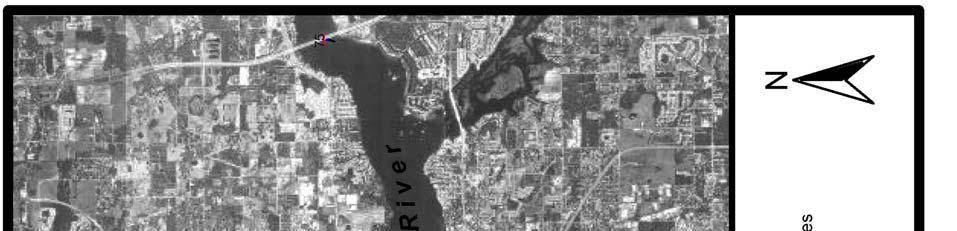
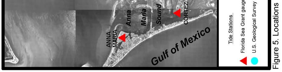
16 e. Signage. There are,8 boating-related signs in the region: hazard warning (55), municipal mooring (), navigation guide (77), private ownership (97), resource protection (78), and speed regulation (9). All signs in the water and along the waterfront, visible to the boater, are included in this inventory. Signage information includes site (bridge, dock, land, seawall, water), type (e.g. buoy, float, panel, piling, etc.), message, status (non-permitted, permitted, unknown), and condition (damaged, ok). f. Site. Site characteristics include the general distribution of biological features within the water body; namely mangrove areas (Figure ) and sea grass beds (Figure ). Major concentrations of mangroves occur: in Palma Sola Bay and Terra Ceia Bay. There is extensive sea grass coverage within each boating region, except for the upstream portion of the Manatee River.. Field Surveys a. Depths. Boat channels were identified by interpretation of section aerials and by field reconnaissance methods. Permitted and non-permitted channel markers were used for orientation wherever present. Field inspection guided final channel alignment. In some cases, it was necessary to perform multiple transects where shoaling was present. Local boaters provided information about existing channel conditions for specific locations. Plots of boat channels were examined in the office by county field staff. A total of 9,9 depth points were recorded for all channel center-lines and approaches to boating facilities. A Trimble Pro XL Global Positioning System (DGPS) with a beacon receiver was used to obtain the geographic position of each depth feature. Positions and measurements were logged using the Trimble TDC data logger and were plotted on :,-scale section aerials. All depths are referenced to the navigation datum, mean lower low water (MLLW). Temporary tide gauges were installed at six locations during the periods of data collection: Anna Maria, Cortez, DeSoto Point, Regatta Point, south Terra Ceia Bay, and north Terra Ceia Bay (Figure 5). Additional tide observations on the Manatee River, during the survey period, were obtained from the USGS for gauges installed at Fort Hamer and at the confluence of the Manatee and Braden Rivers at Bradenton (Figure 5). The University of Florida Department of Coastal and Oceanographic Engineering provided computer programs with which to correct depths to MLLW. b., Facilities and Signs. These boat and waterway features were surveyed using a Trimble Pro XL GPS, a beacon receiver, and a TDC data logger to collect position and attribute information. A laser range finder was used to determine the offset from the observer's location to the position of the surveyed feature. Information about the feature and its location also were plotted on :,-scale section aerials.
17 c. Data Editing. A series of integrity checks was carried out on depth measurements, tide records, and all boat, facility and signage features. The logical consistency of attribute values and the accuracy of feature positions were ascertained. Discrepancies were verified in the field and corrected.. Printed Data Products Printed data products provided to the County consist of thematic information portrayed at both trafficshed (:) and regional (:,) scales. The trafficshedscale thematic information is contained in three 5-page atlases, and the regional scale information in one atlas. All atlases contain an index of page numbers that overlies an aerial photo mosaic of the study region. a. Trafficshed Scale Atlases. Bathymetry -,9 soundings for channel center-lines and adjacent shoals, including FSG field data (9,9) and USACE Manatee River depth points (,658). Depths are corrected to MLLW and presented at -ft resolution.. Channel Depths, Boat Drafts, and Signage -,9 soundings, presented in 6 depth categories (,.5 or,.5 or.,.5 or.,.5 or 5., > 5. ft); boat draft (,78 vessels) presented in 6 draft categories (same ft units as depths); Signs (,8) presented in 6 categories: speed regulation, hazard warning, resource protection, navigation guide, private ownership, municipal mooring.. Analysis - Channel Restrictions, defined as the difference between a channel segment depth and the maximum draft of vessels located up-channel, portrayed in non-restriction and 6 restriction classes (. ft, ft,. ft,.5 ft, ft,.5 ft); and Boat Restrictions (,78 boats, excluding derelict vessels), defined as the difference between boat draft and the controlling center-line depth, portrayed in 6 restriction classes (same ft units as Channel Restrictions). b. Regional Scale Atlases. Bathymetry -,9 soundings that pertain to channel center-lines and adjacent shoals including FSG field data (9,9) and USACE Manatee River depth points (,658). Depths are corrected to MLLW and presented at -ft resolution as colorcoded symbols in generalized depth ranges ( ft, > ft and ft, > ft and 6 ft, > 6 ft).. -,78 boats presented as color-coded symbols in generalized draft categories ( ft, > and ft, > ft and 6 ft, > 6 ft).. Facilities - the distribution of wet and dry slips per facility. A facility is defined as the land use to which a slip is associated, and includes the following categories: anchorage, government, marina, yacht club, boat yard, residence (single family or multi-family), restaurant, or shop. A color-coded symbol, graduated in size, indicates the number of slips per facility, which is presented in 6 categories ( slip, > to 5 slip, >5 to slips, > to 5 slips, >5 to slips, and > to slips). 5
18 . Signs -,8 signs presented as color-coded symbols in 5 classes: speed regulation, hazard warning, resource protection, navigation aid, and private ownership. 5. Sea Grass and Mangroves - the map shows the approximate location of sea grass beds and mangroves in the study area. Sea grass, mangroves, and land cover were extracted from databases obtained from the SWFWMD. Sea grass distribution was mapped from January 995 :,-scale, natural-color aerial photography, and mangrove and land cover information are from a 99, :, scale, GIS coverage. 5. Geographic Information System (GIS) Data Files, Metadata and Software Application The present contract between FSG and Manatee County, which is funded through the WCIND, includes delivery of GIS data files and corresponding metadata. The GIS database for the North Manatee County Regional Waterway Management System includes nine files: boats, boating access channels, access channel depths collected by FSG, access channel depths obtained from USACE, derelict vessels, moorings, signage, trafficsheds, and the Map Atlas index. They have been provided to the County on CD-ROM in ARC/INFO export format and as ArcView.X shape files. The metadata have been provided consistent with federal standards for reporting GIS data descriptions. The WCIND commissioned the development of a customized ArcView (ESRI, Inc.) application for producing print copies of one or more atlas pages during implementation of the Regional Waterway Management System for South Sarasota County (Antonini et al., 998). This application was modified to include atlas pages for North Manatee County and has been delivered to Manatee County and to the WCIND. The application re-creates the printed atlases, which include the following layers, themes and attributes, at the pre-defined :, (in = ft) scale: (a) a background image that consists of U.S. Geological Survey digital orthophoto quarter quadrangles. The orthophotos have a spatial resolution of -meter and were derived from photography. Images are presented as either color-infrared or black-and-white; (b) water depth ( ft increments adjusted to MLLW datum); (c) boat draft, presented as color-coded symbols in 6 draft classes (ft): <=,.5 or,.5 or.,.5 or.,.5 or 5., > 5.; (d) channel center-line depth, accurate to ft and corrected to mean lower low water (MLLW), presented as color-coded symbols in 6 classes (ft): <=,.5 or,.5 or.,.5 or.,.5 or 5., > 5.; (e) signage (speed regulation, hazard warning, resource protection, navigation guide, private ownership, municipal mooring); (f) channel restrictions portrayed in 7 classes (ft): no restriction,.,,.,.5,, Each file is described by a data dictionary that includes information on identification; data quality; spatial data organization; spatial referencing; entities and attributes; distribution and metadata references. 6
19 greater than or equal to.5 feet; and (g) boat accessibility portrayed in 7 restriction depth classes (ft): no restriction,.,,.,.5,, greater than or equal to.5 feet. Upon starting the application, the user is presented with a view (page) showing an index of the study region that includes general land use/land cover and a variation of the USGS quarter quadrangle grid. Each individual index tile represents /6 th of a quarter quadrangle and is labeled with a corresponding atlas page number. The user is able to select and print, at the pre-defined :, scale, a particular page by its number. In order to run this ArcView application, the user must have ArcView.X running under Windows 95, Windows 98, or Windows NT, and possess the appropriate computer and plotting hardware. 6. Institutional Framework for Regional Waterway Systems Management The WCIND met with the FDEP Deputy Secretaries in September 997 and discussed the state's adoption of the waterway management methodology described in this report. The FDEP at that meeting signed a Memorandum of Agreement (MOA), wherein the agency states that it will work as a partner with FSG and the WCIND in implementing a regional waterway management system in WCIND waters. Since Manatee County has taken the initiative within the southwest region by sponsoring these waterway evaluations, the county is well positioned to implement the study's results by proposing to the FDEP an ecosystems-type approach to waterway management, including needed maintenance dredging, habitat restoration, and boat traffic management. 7. Results of the North Manatee County Project a. There are,78 small-craft-type vessels (excluding derelict vessels) in north Manatee County, situated on-the-water or on adjacent salt-water accessible upland parcels (Table ). The majority (. percent) consists of recreational fishing boats, followed by open utility (9. percent), sailboats (7. percent), power cabin/trawlertypes (.8 percent), and speedboats (. percent). There are relatively few kayak/row/canoe (. percent) and personal water craft (.9 percent) at adjacent waterfront locations. The distribution of boat types according to boating region reveals distinctions and patterns that have implications for management decisions. Table lists the actual number of boats surveyed and the number that would be expected if boat types were distributed uniformly throughout all regions, not accounting for other factors, such as variations in access channel depths or location of boating facilities. For example, there are nearly twice the number (5) of open utility boats (utility, bass, skiff, john, or 7
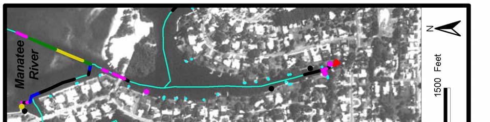
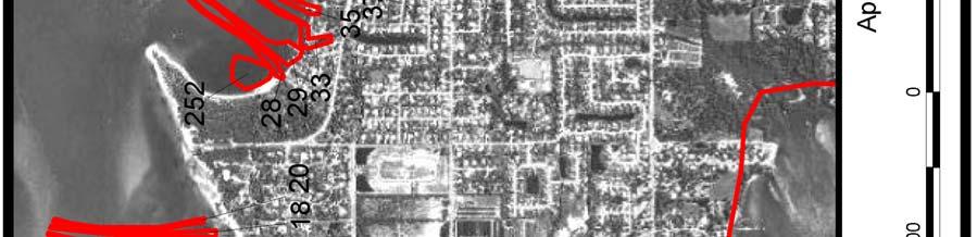
20 pontoon), normally shallow draft vessels, on the upper Manatee River than expected (86). In contrast, there are fewer sail boats (76) located in trafficsheds within Anna Maria Sound than expected (); and more sail boats (7) on the lower Manatee River than expected (6). Eighty-six percent of the sail boats on the lower Manatee River are at Regatta Pointe Marina (), Snead Island Boat Works (7), Bradenton Yacht Club (5), Twin Dolphin Marina and Restaurant (), Boca Del Rio Marina (7), and Manati Shores (). On the lower Manatee River, in general, fewer shallow draft boats (personal water craft, kayak/row/canoe, open utility) and more deeper draft boats (power cabin, trawler, sail) are found than expected. The opposite trend holds for Anna Maria Sound, where more shallow draft vessels and fewer deeper draft vessels are found than expected. There are fewer deeper draft boats on the upper Manatee River, as would be expected given the greater limitation imposed by shallower access channels than found in other regions. The average draft for each boat type on the upper Manatee River is the lowest of all regions. b. Trafficsheds The term trafficshed is used to define the location of concentrations of boats that use a common channel to gain access to open water. This term is a segmentation unit for the purposes of waterway management. Segmentation into trafficsheds permits data generalization and reduction for GIS analysis and subsequent management recommendations. There are trafficsheds in the north Manatee County project area: 57 (5.6 percent) are 'empty' trafficsheds (with no boats); (6.6 percent) contain only to boats; and 6 (7.8 percent) contain 5 or more boats (Table and Figure ). Ninety-six percent of the boats are situated in trafficsheds that contain 5 or more boats and 58% of these are located in Anna Maria Sound trafficsheds. Forty-one percent of all boats are found in the trafficsheds of Bimini Bay/Key Royale (7), Sea Grape Harbor (), Holmes Beach Marina (67), San Remo Shores (5), and Galati Perico Harbor (). c. Accessibility Boat access refers to the difference between a boat s draft and the depth of the shallowest downstream channel segment at MLLW that it must pass to gain access to open water. Four levels of restrictions are denoted: somewhat restricted,. ft or ft deeper; restricted,. ft or.5 ft deeper; severely restricted, ft or.5 ft deeper; and blocked,. ft or more deeper. A summary of the analysis results is presented in the Table 5. A sample of the mapped results, which appear in the 5-page atlases described above, is shown in Figure 6. Twenty-three percent (,7 boats) experience some degree of restriction. Three-quarters of these boats (79 vessels) are somewhat restricted or only experience problems within ft of MLLW: boats ( percent of the total) are restricted by. -.5 ft; 6 (. percent) are severely restricted by -.5 ft; and none are blocked (there are no. ft shoals in any of these waterways). 8
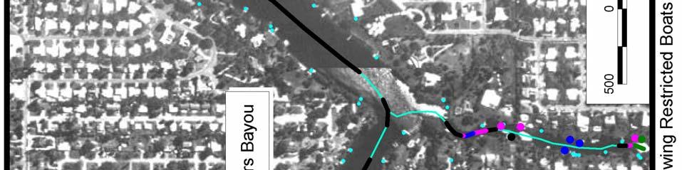
21 The boats in north Manatee County may be grouped into three draft categories: shallow ( to.5 ft); medium ( to.5 ft); and deeper draft (. and greater). Eightynine percent of the boats have shallow and medium drafts of <. feet. Only 5. percent ( vessels) of the shallow draft boats (.5 ft) are restricted (Table 6);.8 percent with medium draft (575 vessels) are restricted; and 5.6 percent of the 55 boats with deeper drafts (. ft) are restricted. Some boats -- those propelled by outboards and in-boards with out-drives -- are capable of varying their draft by raising or lowering the outboard unit of the propulsion system. The accessibility analysis for these boats included two options: (a) normal running conditions, with the lower unit fully extended; and (b) shallow water running, with the lower unit raised, for temporary shoal operation (see Table 7). Fifty-eight percent (6) of the restricted boats (,7) have the ability to raise their lower inboardoutboard units (Table 7). These are concentrated at the lower end of the restriction levels, meaning that raising the lower unit by -. ft would effectively eliminate, or substantially reduce, the restriction problem. The largest numbers of the restricted boats with 'variable draft' are in the.5 ft (7), ft (),.5 ft (), and. ft (66) draft categories (Table 8). d. Locations with Concentrations of Restricted Access Eight trafficsheds account for 58 percent of the restricted boats (Appendix A). They are (numbers of restricted boats listed in parentheses): Sea Grape Harbor (9), Bimini Bay/Key Royale (), Regatta Pointe (79), Palma Sola Estates (), Golf & Bay Estates I (6), Fisherman Village (), Warners Bayou (), and Braden Castle Park/Carleton Arms (). An additional thirteen trafficsheds, each with or more restricted boats, account for percent of all restricted boats: Tropic Isles (8), San Remo Shores (), Cuts Edge Marina (), Riverdale/The Inlets (), Marlow Marine (), Boca Del Rio Marina (8), Tropical Harbor (7), Tree Lakes (7), City of Anna Maria (7), Holmes Beach Marina (6), Cove Sound Moorings (), Manati Shores (), and Flamingo Cay West (). Eighty-one percent of the restricted boats are situated in these trafficsheds. The relative proportions of restricted boats at the twenty-one locations are shown by graduated-size dots on Figure 7. e. Channel Restrictions There are approximately 5 statute miles of waterways in the north Manatee Project area. A total of,9 soundings were used to construct channel depth segments, which then were analyzed to determine the location and extent of restrictions (shoals) that impede boat traffic. Results of the analysis are presented in the Table 9a and 9b. A sample of the mapped results, which appear in the 5-page atlases described above, is shown in Figure 6. Boat traffic is restricted in approximately.5 percent (. mi.) of all waterways. However, nearly 7 percent of the restricted channels (5.5 mi.) only impede vessel transit by shoals less than or equal to feet. The remaining percent of the 9
22 restricted channels consist of: 6. mi. of. to.5 ft shoals, and.7 mi. with to.5 ft shoals (see Table 9). Forty-three percent of the restricted channels are found at eight locations (restricted channel lengths listed in parentheses): Bimini Bay/Key Royale (. mi.), Palma Sola Estates (.5 mi.), Warners Bayou (. mi.), San Remo Shores (. mi.), Riverdale/The Inlets (. mi.), Manati Shores (.8 mi.), Flamingo Cay West (.7 mi.), and Fisherman Village (.6 mi.). Another 6 percent are located at thirteen locations: Tropic Isles (.6 mi.), Regatta Pointe (.6 mi.), Tropical Harbor (.6 mi.), River Point ( mi.), Cuts Edge Marina ( mi.), Tree Lakes (. mi.), Sea Grape Harbor (. mi.), Golf and Bay Estates I (. mi.), Riverside Drive East (. mi.), Holmes Beach Marina (. mi.), Wares Bayou (. mi.), Braden Castle Park/Carleton Arms (. mi.), and City of Anna Maria (. mi.). The remaining 78 trafficsheds with restricted channels account for the balance ( percent) of the restricted channels (Appendix B). There are several secondary access channels, serving two or more trafficsheds, that are heavily used by boaters to gain entry to the Intracoastal Waterway (ICW) and the Manatee River or Terra Ceia Bay. They are the Palma Sola Bay entrance and the Cutoff, both of which have relatively short but restricted channel segments. The high volume of boat traffic traversing these arteries makes them strong candidates for maintenance dredging. f. Relation of Boat Accessibility to Channel Restriction There are trafficsheds which, combined, contain 79 percent of all restricted boats and 68 percent of all restricted channels. The boat-channel relations for these locations are shown in Table. Sea Grape Harbor and Bimini Bay/Key Royale standout from the remainder for their combined relative totals. As a group, they have almost two-times the combined numbers of restricted boat and channels above the next largest concentration. There are some locations, such as Sea Grape Harbor, Regatta Pointe, Braden Castle Park/Carleton Arms, and Gulf and Bay Estates I, whose estimated dredge requirements are low relative to their concentrations of restricted boats. (For trafficshed specific information on restricted boat counts and channel lengths (ft), see Appendixes A and B.) g. Projected Dredging Requirements Dredging requirements were projected for all trafficsheds (Appendix C). Tables and present detailed analyses for those trafficsheds with or more restricted boats. Tables a and b provide the respective dredging estimates for the Cutoff and Palma Sola Bay access channels. The ratio of Total Dredge (Tables and, righthand column) to Restricted (Tables and, left-hand column) gives the per boat dredge volume for a given trafficshed. For example, under the Normal Clearance option (Table ), Sea Grape Harbor, with 9 restricted boats and 97 yd estimated total dredge, would have a per boat dredge requirement of.9 yd ; whereas, for Tropic isles, the per boat dredge value would be 69 yd. Estimates of required dredging were calculated using two scenarios:
23 i) Normal (MLLW = ft datum) Depth Clearance (Table ); and ii) Additional Depth Clearance, which requires a ft clearance between lowest point of boat and channel bottom (Table ). 5 Dredging amounts are in cubic yards and assume an average channel width of ft. Under Scenario (I) Normal Clearance, the amount of dredge required for a -ft channel segment restricted by.5 ft, is equal to the restriction amount, times a -ft channel width, divided by 7 (7 ft per yd ), or approximately cubic yards. [ ft x.5 ft x ft ] / 7 ft per yd Given the above assumptions, the depth of dredge equals the restriction level of the channel, e.g., a. ft channel restriction level requires no dredging, whereas a channel with a.5 restriction level would require a.5 ft depth cut. Under Scenario (ii) Additional Depth Clearance, the same obstruction would require approximately 85 cubic yards: [ ft x (.5 ft +. ft ) x ft ] / 7 ft per yd In this case, restricted channel segments would be dredged to the restriction level plus an additional foot, e.g., a somewhat restricted segment ( ft restriction) would be dredged to +. =.5 ft. A comparison of the results between Normal (approximately 5,59 yd ) and Additional (approximately,779 yd ) shows almost times the amount of spoil would need to be removed, overall, to achieve the additional depth clearance. The top trafficsheds which, combined, contain 79 percent of all restricted boats and 68 percent of all restricted waterways, represent over two-thirds of the dredging needs of this region. Figure 8 shows the locations of these trafficsheds, which are represented on the map by graduated-size dots. The top six restricted trafficsheds account for 6 percent (6,9 yd ) of projected dredging requirements for Normal Clearance (Bimini Bay/Key Royale, San Remo Shores, Palma Sola Estates, Regatta Pointe, Tropic Isles, and Fisherman Village); and they account for 5 percent (6,898 yd ) for Additional Clearance (Bimini Bay/Key Royale, Palma Sola Estates, San Remo Shores, Warners Bayou, Manati Shores, and Riverdale/The Inlets. h. Signage There are,8 boating-related signs in the region. Fifty-seven percent (65) are in Anna Maria Sound, 7 percent (9) are on the downstream portion of the Manatee River, percent (57) are on Manatee River upstream, and percent (8) 5 This may be considered an extended application of the FDEP Rule for Aquatic Preserve Waters, which requires, in non-man-made canals or previously un-dredged portions of coastal streams, a ft clearance at the dock between the lowest point of the boat hull or fixed drive unit (whichever is lower) and any submerged bottom lands or tops of sea grasses.
24 are in Terra Ceia Bay. Eighty-four percent of all signs (967) are situated in trafficsheds, while percent mark primary and secondary navigation channels or are found in open bay waters. Sixty-three percent (77) are navigation-type, 9 post speed regulations, 55 are for hazard warning, 97 identify private ownership, and 78 are for resource protection. The most common type of sign is 'piling' (9 percent). Tables a and b detail this information. 8. Special Management Considerations Warranted in Terra Ceia Bay Terra Ceia Bay is an Aquatic Preserve with a stringent water quality classification, as identified in section 6-.7 of the Florida Administrative Codes. The aquatic preserve status of Terra Ceia Bay is designed to promote conservationoriented use. Permission may be authorized by the state regulatory agency (FDEP), on a case-by-case basis, for structures necessary to perform water-dependent activities that must have access to sovereign lands and waters, because the activity requires it (e.g., recreation, transportation) and where the use of state land or water is an integral part of the activity. Examples of such cases include: public navigation projects, maintaining existing navigation channels; creating and maintaining commercial or industrial docks, piers or marinas; creating or maintaining private docks for water access by riparian owners, and maintenance dredging for navigation right-of-way to docks. 9. Conclusions and Recommendations The waterway management needs of northern Manatee County are uniquely defined by the geography of boat source areas (trafficshed); there are waterways with many boats, and areas with few boats. The relations of concentrations of boats to access channel length, and of boat draft to controlling channel depth, determine the degree of boat accessibility and channel restrictions. An understanding of these relations is fundamental to developing and implementing rational waterway management policy. The results of this study argue in favor of prioritizing channel improvements based on greatest need; they also highlight conditions within north county waters that should guide region-wide bay water use policies. a. Short-term. The results indicate that the greatest problems of boat access and channel restrictions occur in a relatively few trafficsheds. The trafficsheds that contain the greatest numbers of restricted boats are Sea Grape Harbor, Bimini Bay/Key Royale, and Regatta Pointe; they account for percent of the boat access problems and 5. percent of the channel restrictions. Manatee County should concentrate initial waterway management efforts at these locations. Another eight waterways (Palma Sola
25 Estates, Golf and Bay Estates I, Fisherman Village, Warners Bayou, Braden Castle Park/Carleton Arms, Tropic Isles, San Remo Shores, and Cuts Edge Marina) account for additional.5 percent of the boat access problems and 9. percent of the channel restrictions. In some cases, such as Sea Grape Harbor, Regatta Pointe, Braden Castle Park/Carleton Arms, and Golf and Bay Estates I, relatively short segments of channel restrictions impede relatively large numbers of boats: the high benefit-to-cost is an incentive to make channel improvements at these locations.. There are several secondary access channels, serving two or more trafficsheds, that are heavily used by boaters to gain entry to the Intracoastal Waterway and the Manatee River or Terra Ceia Bay. They are the Palma Sola Bay entrance and the Cutoff, both of which have relatively short but restricted channel segments. The high volume of boat traffic traversing these arteries makes them strong candidates for maintenance dredging.. A large number () of trafficsheds (6.6 percent of all boat source areas) have relatively short access channels and few boats. There are access problems at some of these locations, but the low numbers of boats and channel lengths per waterway mean that the per unit channel improvement cost will be high relative to the improved access for each boat. Many of these small trafficsheds are situated on the Manatee River where channels link one or two single-family residence boat docks to the main river channel.. The waterway inventory information in the project's GIS database has value and application beyond the bay water planning and management results presented in this report. This information should be reformatted and provided to shorefront residents and boaters in the trafficsheds targeted for waterway improvements, as Waterway Maps, showing channel center-line depths, boat facilities, and natural resource conditions. (The WCIND and FSG have produced similar maps of anchorages.) This information can sensitize users to the environmental conditions of the waterways and provide a basis for instilling stewardship and responsible boating practices. 5. Manatee County should consider implementing these recommendations under the Memorandum of Agreement (MOA) for Regional Waterway Systems Management. This MOA is designed to offer local governments and local waterfront community organizations with a mechanism to effect regional waterway improvements within an ecosystem, place-based management approach. The MOA provides an avenue for pursuing region-wide permit review and project applications. A proposal should be submitted to the FDEP that is county-wide in coverage and comprehensive in scope, based on the results of this Project covering north county waters, and the Sarasota Bay Pilot Study which covers south county waters. b. Long-term 6. Manatee County and the WCIND have an investment in this Regional Waterway Management System. This system should be maintained and enhanced in
26 order to respond to the county's growing needs for rapid assessment and comprehensive geographic analysis of its bay water resources. 7. The Regional Waterway Management System can be strengthened by linking it to the county's upland databases. This will facilitate responding to more complex issues which transcend land-water boundaries, such as identifying sources of sedimentation and allocating maintenance dredging costs based on sediment-source contributors and waterway users. 8. The Regional Waterway Management System database should be updated periodically with county-wide boat information. The WCIND has developed a preliminary plan based on revising the annual Vessel Registration Form. This plan, to incorporate information on boat type, draft and location onto the form, offers a systematic updating method which should be pursued through the County Tax Collector's Office and the State Bureau of Vessel Titles and Registrations. 9. The bathymetric surveys should be updated, as needed, to identify shoaling conditions of the waterways. The WCIND is collaborating, through Florida Sea Grant, with the National Oceanic and Atmospheric Administration (NOAA) Marine Chart Division in a program to redesign coastal charts for recreational waterway users. There are opportunities for Manatee County to partner with this federal charting agency and thereby share survey information on a periodic basis.. The appropriate County department should be provided with the GIS equipment, software and training to carry out waterway inventory and analysis, in order to respond to routine customer requests for information and technical services. The Florida Cooperative Extension Service and State University System should continue to provide institutional and professional support References Antonini, G.A. and P. Box, 996, A Regional Waterway Systems Management Strategy for Southwest Florida, Florida Sea Grant, TP-8, Gainesville, FL: Florida Sea Grant. Antonini, G.A., R. Swett, S. Schulte, and D. Fann, 998, Regional Waterway Management System for South Sarasota County, TD-, Gainesville, FL: Florida Sea Grant.
27 Table. Distribution of and Trafficshed Types in North Manatee County by Boating Region Trafficshed Boat Trafficshed Boating Region Type Count Count No to 7 5 or More 5 9 Anna Maria Sound Total 5 7 No 5 to 6 5 or More 56 Terra Ceia Bay Total 55 No 9 to or More Manatee River above US Bridge Total 8 59 No to or More 88 7 Manatee River below US Bridge Total No 57 to 8 5 or More 97 6 Total All North Manatee County Total 78 Trafficsheds are categorized by the number of boats present at the time of the field survey. The relative distribution of boats by trafficshed resulted in three broad classes: trafficsheds with a) 5 or more boats, b) to boats and, c) no boats. 5
28 Table. Counts of Boat Types in North Manatee County Boat Type Recreational Fishing. Open Utility Sail Power Cabin/Trawler Speed 95. Kayak/Row/Canoe. Personal Water Craft Table excludes derelict vessels tallied in survey 6
29 Table. Distribution of Boating Facilities in North Manatee County by Boating Region Facility Type Anna Maria Sound Terra Ceia Bay Manatee River above US Manatee River below US Anchorage Government 5 Marina/Yard/Club Motel/Hotel/Restaurant/Shop Total Total 7
30 Table. Distribution of Boat Types in North Manatee County by Boating Region. Anna Manatee Manatee Terra All Boat Type Maria River above River below Ceia Bay Regions Sound US US Kayak/Row/Canoe 9 8 percent of row total percent of column total percent of table total Expected value 8 8 Open Utility percent of row total percent of column total percent of table total Expected value percent of row total percent of column total percent of table total Expected value Personal Water Craft percent of row total percent of column total percent of table total Expected value Power Cabin/Trawler percent of row total percent of column total percent of table total Expected value Recreational Fishing percent of row total percent of column total percent of table total Expected value Sail percent of row total percent of column total percent of table total Expected value Speed percent of row total percent of column total percent of table total Expected value Total percent of row total percent of column total percent of table total Expected value
31 Table 5. Boat Access Levels for North Manatee County by Boating Region. Restriction Level Anna Maria Sound Terra Ceia Bay Manatee River above US Manatee River below US Row Column of Total Row Column of Total Row Column of Total Row Column of Total All Boating Regions All Unrestricted Restricted Somewhat Restricted Restricted Severely Restricted Blocked Row Column of Total Boat access levels refer to the difference between a boat's draft and the depth (MLLW) of the shallowest, downstream channel segment. Somewhat Restricted:. feet or feet deeper. Restricted:. feet or.5 feet deeper. Severely Restricted: feet or.5 feet deeper. Blocked:. feet or more deeper. 9
32 Table 6. Number of Restricted and Levels of Access by Boat Draft Category. Draft Category Anna Maria Sound Terra Ceia Bay Manatee River above US Manatee River below US Row Column of Total Row Column of Total Row Column of Total Row Column of Total All Boating Regions Shallow 9 58.%.9%.%.%.7%.% 56 5.%.8% 5.% 6.% 6.6%.%.%.%.% Medium % 57.% 8.% 9 6.% 59.% 8.8% 5 8.% 65.%.% 8.% 8.% 7.7% 575.% 5.9% 5.9% Deeper 9 7.% 7.9% 8.9% 6.% 6.%.9%.%.%.% 6 6.% 55.%.% 5.%.9%.9% Total %.% 9.6% 56.9%.%.9% 6 5.%.% 5.%.%.%.% 7.%.%.% Row Column of Total Shallow: to.5 feet Medium: to.5 feet Deeper:. feet and greater
33 Table 7. Variable Draft Capability of Restricted in North Manatee County. Restriction Level Anna Maria Sound Terra Ceia Bay Variable Draft No Yes Variable Draft Variable Draft No Yes Variable Draft Manatee River above US Manatee River below US Variable Draft No Yes Somewhat Restricted Restricted Severely Restricted Blocked Total Restricted of Column Total Variable Draft Variable Draft No Yes Variable Draft All Boating Regions Variable Draft No Yes Variable Draft
34 Table 8. Variable Draft Capability by Boat Draft for Restricted in North Manatee County. Draft (feet) Anna Maria Sound Variable Draft No Yes Row Column Terra Ceia Bay Manatee River above US Manatee River below US Variable Draft No Yes Row Column Variable Draft No Yes Total Row Column Variable Draft No Yes Row Column All Boating Regions Variable Draft No Yes Row Column Note: Row and column percentages are based on the number of restricted boats with variable draft capabilities.
35 Table 9. Channel Restrictions within North Manatee County. a. Trafficsheds and Access Channels Combined. Restriction Level Length (feet) Anna Maria Sound Terra Ceia Bay Manatee River above US Manatee River below US Row Column of Total Length (feet) Row Column of Total Length (feet) Row Column of Total Length (feet) Row Column of Total Length (feet) All Boating Regions All Channels Unrestricted Channels Somewhat Restricted Restricted Severely Restricted Blocked Row Column of Total b. Access Channels Serving Two or More Trafficsheds. Cutoff - Manatee River Entrance Cutoff - Terra Ceia Bay Entrance Palma Sola Bay Entrance Total Restriction Level Length (feet) Row Column of Total Length (feet) Row Column of Total Length (feet) Row Column of Total Length (feet) Row Column of Total All Channels Unrestricted Channels Somewhat Restricted Restricted Severely Restricted Blocked Restriction level refers to the difference between a channel segment depth (MLLW) and the deepest draft boat located upstream from the segment. Somewhat Restricted:. feet or feet shallower. Restricted:. feet or.5 feet shallower. Severely Restricted: feet or.5 feet shallower. Blocked:. feet or more shallower.


36
37 Table. Projected Dredge Requirements for Normal Clearance - (Cubic Yards) Restricted Somewhat Severely Trafficshed Restricted Restricted Restricted Total ALL Trafficsheds 7,8 7,9 5,96 5,59 Bimini Bay/Key Royale,,7 5,986 San Remo Shores 697,5 75,5 Palma Sola Estates 869,, Regatta Pointe 79 66,89 99,58 Tropic Isles 8 7,99 5,97 Fisherman Village ,885 Manati Shores 55,,86 Warners Bayou ,79 Tropical Harbor 7 7,99,668 Cuts Edge Marina,5,577 Sea Grape Harbor Riverdale/The Inlets City of Anna Maria Flamingo Cay West Tree Lakes Braden Castle Park/Carleton Arms Cove Sound Moorings Golf & Bay Estates I 6 78 Boca Del Rio Marina Marlow Marina Holmes Beach Marina Top Restricted 89 8, 7,5,6 8,575 5
38 Table. Projected Dredge Requirements for Additional Depth ( ft.) Clearance - (Cubic Yards) Restricted Somewhat Severely Trafficshed Restricted Restricted Restricted Total ALL Trafficsheds 7 7,769 5,67 8,8,779 Bimini Bay/Key Royale 8,,75, San Remo Shores,5, ,6 Palma Sola Estates,6,69 9, Regatta Pointe 79,,6 8,6 Tropic Isles 8,,99 75,7 Fisherman Village,7, 5, Manati Shores,55,6 5,7 Warners Bayou,77, 7 6,88 Tropical Harbor 7,59,, Cuts Edge Marina 859,9,5 Sea Grape Harbor 9,6 8 65,69 Riverdale/The Inlets,56,8,77 City of Anna Maria 7,89 88,96 Flamingo Cay West,86 7, Tree Lakes 7,9,9 Braden Castle Park/Carleton Arms,7,7 Cove Sound Moorings Golf & Bay Estates I 6,655 68,9 Boca Del Rio Marina Marlow Marina Holmes Beach Marina 6,577,577 Top Restricted 89 8,76,58,878 85, 6
39 Table. Projected Dredge Requirements for Access Channels, The Cutoff and Palma Sola Bay Entrance a. Normal Clearance - (Cubic Yards) Location Somewhat Severely Restricted Restricted Restricted Blocked Total Palma Sola Bay Entrance Cutoff - Terra Ceia Bay Entrance Cutoff - Manatee River Entrance 8 8 Total 88 8 b. Additional Depth ( ft.) Clearance - (Cubic Yards) Location Somewhat Severely Restricted Restricted Restricted Blocked Total Palma Sola Bay Entrance 6 6 Cutoff - Terra Ceia Bay Entrance Cutoff - Manatee River Entrance 6 6 Total
40 Table. Distribution of Boating-Related Signs. a. Categories of Signs by Boating Region. Boating Region Total Hazard Warning Municipal Mooring Navigation Guide Private Ownership Resource Protection Speed Regulation Anna Maria Sound Terra Ceia Bay Manatee River above US Manatee River below US Totals b. Types of Signs by Boating Region. Boating Region Total Buoy Float Panel PILINGS Concrete Metal PVC Wood Structure Anna Maria Sound Terra Ceia Bay 8 Manatee River above US Manatee River below US Totals


41 9

42


43


44


45


46


47 5


48 6
49 7
50 8
51 9
52 Appendix B by Access Categories Trafficshed Trafficshed Somewhat Channel Length (feet) Severely Number Name Restricted Restricted Restricted Blocked All Restricted Sea Grape Harbor, , Bimini Bay/Key Royale 9,77,5,7 8 Regatta Pointe,5,98 67,9 89 Palma Sola Estates 5,8,7 8,5 7 Golf & Bay Estates I,9 8,9 8 Fisherman Village, 89 9, 97 Warners Bayou 5,78 8 6,87 5 Braden Castle Park/Carleton Arms,8,8 Tropic Isles,598,5 9,86 5 San Remo Shores,8,6 5,99 Cuts Edge Marina 8,56,95 Riverdale/The Inlets, ,58 Marlow Marina Boca Del Rio Marina Tropical Harbor,68,58,66 8 Tree Lakes,, City of Anna Maria,7 559,666 Holmes Beach Marina,9,9 6 Cove Sound Moorings Manati Shores,7,769,69 9 Flamingo Cay West,5,756 Regal Point Estates V Sunny Shores ,5 5 Seafood Shack/Yacht Sales , Bradenton Yacht Club I Riverside Drive East,75 77,8 9 Golf & Bay Estates III,,8 McLewis Bayou,8 5, Golf & Bay Estates II River Point,9 7, Snead Island Boat Works 8 Shaws Point , 56 Wares Bayou, 67 7, Mariners Cove East,69 89,
53 Trafficshed Trafficshed Somewhat Channel Length (feet) Severely Number Name Restricted Restricted Restricted Blocked All Restricted 9 956, Tropcial Harbor I Bay Colony , , Mariners Cove West Regal Point Estates II 96 96
54 Trafficshed Trafficshed Somewhat Channel Length (feet) Severely Number Name Restricted Restricted Restricted Blocked All Restricted Cutoff Terra Ceia Bay Entrance (N , Cutoff Manatee River Entrance (N Palma Sola Bay Entrance (Not in 9 9 Total 8,58,,89 7,7
55 Appendix C: Data Inventory on Access Channel and Trafficshed Waterways, Boat and Facility Characteristics This appendix presents information on boats, mooring, facilities, boat and channel restrictions, and required dredging to provide boat access from trafficshed to open bay under several options (Normal Clearance and Additional Depth ( ft) Clearance). The appendix tables are organized by trafficshed (navigable waterways that serve as boat source areas). There are trafficsheds in north Manatee County; these are identified by a positive number in the Appendix C tables. The general locations of these trafficsheds are shown on the on the accompanying maps. To locate a particular trafficshed, refer to the table, List of Trafficsheds and Corresponding Map Numbers, which immediately precedes the maps. There are four trafficsheds identified by a negative number which refer to: open water (-999); the Cutoff, Terra Ceia Bay entrance (-998); the Cutoff, Manatee River entrance (-997); and Palma Sola Bay entrance (-996). Open Water (-999) contains moorings and facilities, but no channels. The secondary access channels (-998, -997, -996) serve two or more trafficsheds that are heavily used by boaters to gain entry to: the Intracoastal Waterway (Palma Sola Bay entrance [-996] which controls access to trafficsheds 89, 9,,,, 5), the Cutoff to the Manatee River [-997] for trafficsheds 7, 8, 9, 5, 5, and the Cutoff to Terra Ceia Bay [-998] for trafficsheds 9,,,,,, 5, 6. Refer to the large-scale maps at the County Environmental Management Department for specific locations and extent.
56 Appendix C. List of Trafficsheds and Corresponding Map Numbers. Trafficshed Map Trafficshed Map Trafficshed Map Trafficshed Map Trafficshed Map Number Number Number Number Number Number Number Number Number Number


57 5


58 6


59 7


60 8


61 9


62 5


63 5


64 5


65 5
Regional Waterway Management System For Lee County, Phase 3
 August 2002 TD 5 Regional Waterway Management System For Lee County, Phase 3 David A. Fann Robert A. Swett Lana Carlin Alexander Gustavo A. Antonini This technical paper was supported by the Lee County
DRAFT. October 17, 2014 File No Mr. Brendhan Zubricki Town Administrator Essex Town Hall 30 Martin Street Essex, MA.
 GZA GeoEnvironmental, Inc. Engineers and Scientists October 17, 2014 File No. 18.0171857.00 Mr. Brendhan Zubricki Town Administrator Essex Town Hall 30 Martin Street Essex, MA. 01929 DRAFT Re: Essex River
INTERNATIONAL HYDROGRAPHIC SURVEY STANDARDS
 INTERNATIONAL HYDROGRAPHIC SURVEY STANDARDS by Gerald B. MILLS 1 I. Background The International Hydrographic Organization (IHO) traces its origin to the establishment of the International Hydrographic
MEMORANDUM. Existing Operations. City of Clearwater. Michael Herrman. Date: January 26, Seminole Boat Launch Overview. M&N Job No.
 1509 W. Swann Avenue, Suite 225 Tampa, FL 33606 (813) 258-8818 Fax (813) 258-8525 www.moffattnichol.com MEMORANDUM To: From: City of Clearwater Michael Herrman Date: Subject: Seminole Boat Launch Overview
Good Mooring to You! Jensen Beach Mooring Field. Kathy Fitzpatrick, P.E. Coastal Engineer, Martin County
 Good Mooring to You! Kathy Fitzpatrick, P.E. Coastal Engineer, Martin County Penny Cutt Regional Manager, Coastal Systems International Mooring Field Advantages Provide a safe and secure anchorage at a
SACO RIVER AND CAMP ELLIS BEACH SACO, MAINE SECTION 111 SHORE DAMAGE MITIGATION PROJECT APPENDIX F ECONOMIC ASSESSMENT
 SACO RIVER AND CAMP ELLIS BEACH SACO, MAINE SECTION 111 SHORE DAMAGE MITIGATION PROJECT APPENDIX F ECONOMIC ASSESSMENT Department of the Army New England District, Corps of Engineers 696 Virginia Road
City of Pittsfield HARBORMASTER RULES AND REGULATIONS on docks
 City of Pittsfield HARBORMASTER RULES AND REGULATIONS on docks Definitions Dock: Any permanently fixed or floating structure extending from the upland into the water, capable of use for vessel mooring
MONROE COUNTY NEW YORK
 MONROE COUNTY NEW YORK Intersection Accident Database Enhancement Project (UPWP 4380) FINAL January 2008 Prepared By: Prepared For: Bergmann Associates 200 First Federal Plaza 28 East Main Street Rochester,
Plot the Path. Mary Anne Otten. lesson three
 Plot the Path Mary Anne Otten lesson three Subject/Grade: Grade 2, Math, Social Studies, Science Duration: one class period Materials needed: Per class: Day the Great Lakes Drained Away by Charles Ferguson
City of Elizabeth City Neighborhood Traffic Calming Policy and Guidelines
 City of Elizabeth City Neighborhood Traffic Calming Policy and Guidelines I. Purpose: The City of Elizabeth City is committed to ensure the overall safety and livability of residential neighborhoods. One
CHAPTER 6 10/29/2018 Clean Version REGULATING PIERS, WHARVES, MOORING BUOYS, SWIMMING RAFTS AND INFLATABLES ON ROCK LAKE
 1 2 3 4 5 6 7 8 9 10 11 12 13 14 15 16 17 18 19 20 21 22 23 24 25 26 27 28 29 30 31 32 33 34 35 36 37 38 39 40 41 42 43 44 45 46 CHAPTER 6 10/29/2018 Clean Version REGULATING PIERS, WHARVES, MOORING BUOYS,
RESEARCH Massachusetts Recreational Boater Survey. Project Summary
 Coastal and Marine Spatial Planning RESEARCH Project Summary 2010 Massachusetts Recreational Boater Survey The 2010 Massachusetts Recreational Boater Survey gathered spatial and economic data relating
Redondo Beach Boat Launch Ramp Facility
 Redondo Beach Boat Launch Ramp Facility Feasibility Report for the California Department of Boating and Waterways 2015 Grant Cycle For the City of Redondo Beach Submitted by March 13, 2014 Table of Contents
Juneau Douglas Harbor
 Juneau Douglas Harbor Douglas Harbor Page 2 of 8 Condition of Improvements 31 December 2015 Douglas Harbor, Alaska (CWIS No. 072789, 180942) Authorization Rivers and Harbors Act, 3 July 1958 (House Doc.
Expanding Anchoring Away
 Expanding Anchoring Away Vessel taxonomy &territorial waters Maritime and admiralty law distinguished The right to navigate Federal navigational servitude as applied CZMA, reverse federalism & Florida
CITY OF NAPLES STAFF REPORT
 Meeting of 8/9/17 Variance Petition 17-V5 CITY OF NAPLES STAFF REPORT To: Planning Advisory Board From: Planning Department Subject: Variance Petition 18-V2 Petitioner: Ian & Catherine Delaney Agent: Jeff
ADOT Statewide Bicycle and Pedestrian Program Summary of Phase IV Activities APPENDIX B PEDESTRIAN DEMAND INDEX
 ADOT Statewide Bicycle and Pedestrian Program Summary of Activities APPENDIX B PEDESTRIAN DEMAND INDEX May 24, 2009 Pedestrian Demand Index for State Highway Facilities Revised: May 29, 2007 Introduction
Coastal Harbors and Waterways, NC (Shallow Draft Navigation) (O&M)
 (O&M)") Coastal Harbors and Waterways, NC (Shallow Draft Navigation) (O&M) Shallow draft coastal harbors include a subsistence harbor at Silver Lake CONGRESSIONAL DISTRICT: NC 3, 7 DATE: 23 April 2018 1. AUTHORIZATION:
Coastal Harbors and Waterways, NC (Shallow Draft Navigation) (O&M) Shallow draft coastal harbors include a subsistence harbor at Silver Lake CONGRESSIONAL DISTRICT: NC 3, 7 DATE: 23 April 2018 1. AUTHORIZATION:
Passage Key Inlet, Florida; CMS Modeling and Borrow Site Impact Analysis
 Passage Key Inlet, Florida; CMS Modeling and Borrow Site Impact Analysis by Kelly R. Legault and Sirisha Rayaprolu PURPOSE: This Coastal and Hydraulics Engineering Technical Note (CHETN) describes the
Another essential characteristic of boat channel geography is the form and spacing of channel
 Another essential characteristic of boat channel geography is the form and spacing of channel segments.some channels are simple, and others are complex. The channel systems include: finger canals or basins;
Nome Harbor Page 2 of 12
 Nome Harbor Nome Harbor Page 2 of 12 Condition of Improvements 30 December 2015 Nome Harbor, Alaska (CWIS No. 010422, 012270, 072742, 087755) Authorization (1) Rivers and Harbors Act, 8 August 1917 (House
Exhibit 1 PLANNING COMMISSION AGENDA ITEM
 Exhibit 1 PLANNING COMMISSION AGENDA ITEM Project Name: Grand Junction Circulation Plan Grand Junction Complete Streets Policy Applicant: City of Grand Junction Representative: David Thornton Address:
Coastal Harbors and Waterways, NC (Shallow Draft Navigation) (O&M)
 (O&M)") Coastal Harbors and Waterways, NC (Shallow Draft Navigation) (O&M) Shallow draft coastal harbors include a subsistence harbor at Silver Lake CONGRESSIONAL DISTRICT: NC 3 and 7 DATE: 23 February 2015 1.
Coastal Harbors and Waterways, NC (Shallow Draft Navigation) (O&M) Shallow draft coastal harbors include a subsistence harbor at Silver Lake CONGRESSIONAL DISTRICT: NC 3 and 7 DATE: 23 February 2015 1.
New Jersey Coastal Zone Overview. The New Jersey Beach Profile Network (NJBPN) 3 Dimensional Assessments. Quantifying Shoreline Migration
 3 Dimensional Assessments. Quantifying Shoreline Migration") New Jersey Coastal Zone Overview The New Jersey Beach Profile Network (NJBPN) Objectives Profile Locations Data Collection Analyzing NJBPN Data Examples 3 Dimensional Assessments Methodology Examples Quantifying
New Jersey Coastal Zone Overview The New Jersey Beach Profile Network (NJBPN) Objectives Profile Locations Data Collection Analyzing NJBPN Data Examples 3 Dimensional Assessments Methodology Examples Quantifying
BookletChart. Intracoastal Waterway Matecumbe to Grassy Key NOAA Chart A reduced-scale NOAA nautical chart for small boaters
 BookletChart Intracoastal Waterway Matecumbe to Grassy Key NOAA Chart 11449 A reduced-scale NOAA nautical chart for small boaters When possible, use the full-size NOAA chart for navigation. Published by
NEED FOR SUPPLEMENTAL BATHYMETRIC SURVEY DATA COLLECTION
 305 West Grand Avenue, Suite 300 Montvale, New Jersey 07645 Phone 201.930.9890 Fax 201.930.9805 www.anchorqea.com M EMORANDUM To: Caroline Kwan and Nica Klaber U.S. Environmental Protection Agency Region
Eelgrass and Macroalgae Presence/Absence Preliminary Surveys BHP Proposed Grays Harbor Potash Export Facility A Task 400
 Memorandum 40600-HS-MEM-55036 Revision 0 Date: 26 July 2018 Subject: Eelgrass and Macroalgae Presence/Absence Preliminary Surveys BHP Proposed Grays Harbor Potash Export Facility A17.0202.00 Task 400 INTRODUCTION
CLAM PASS ANNUAL RESTORATION & MANAGEMENT PLAN TIDAL ANALYSIS ELEMENT REPORT NO. 13
 CLAM PASS ANNUAL RESTORATION & MANAGEMENT PLAN TIDAL ANALYSIS ELEMENT REPORT NO. 13 Submitted to: Pelican Bay Services Division Prepared by: Humiston & Moore Engineers H&M File No. 13-078 November 2012
V. HARBOR DEPTHS, CHANNEL DESIGN AND PROPOSED CONSTRUCTION AND DREDGING
 V. HARBOR DEPTHS, CHANNEL DESIGN AND PROPOSED CONSTRUCTION AND DREDGING A. DISCUSSION: For the most part, projects that involve dredging and construction require a comprehensive design and review process
Chapter I: Marine Resources
 NOTE TO READERS: This is a draft of the Kennebunk Comprehensive Plan. The Comprehensive Plan provides us with a description of the town today in a range of categories, and identifies issues and recommendations
FINAL ENVIRONMENTAL IMPACT STATEMENT ON BROWARD COUNTY SHORE PROTECTION PROJECT SEGMENTS II AND III BROWARD COUNTY, FLORIDA
 FINAL ENVIRONMENTAL IMPACT STATEMENT ON BROWARD COUNTY SHORE PROTECTION PROJECT SEGMENTS II AND III BROWARD COUNTY, FLORIDA 1. PROJECT PURPOSE AND NEED 1.1. PROJECT AUTHORITY. 1.1.1. INITIAL AUTHORIZATION.
Chapter 5 FUNCTIONAL CLASSIFICATION
 Chapter 5 FUNCTIONAL CLASSIFICATION Functional classification is a system by which streets and roadways may be distinguished by types according to their function within the entire transportation network.
Lake Tahoe Shoreline Plan. 01 Scope
 Lake Tahoe Shoreline Plan 01 Scope 09.20.2016 1 Brief Description The Shoreline Plan needs a defined scope to focus work efforts and complete the planning process by the end of 2018 (within the existing
Appendix F: Ecology F-6 Methodology for Estimating Potential Hydroacoustic Impacts to Abundant Hudson River Fish Species and Shortnose Sturgeon from
 Appendix F: Ecology F-6 Methodology for Estimating Potential Hydroacoustic Impacts to Abundant Hudson River Fish Species and Shortnose Sturgeon from Pile-driving Activities during Construction of the Tappan
STUDY REPORT W&AR-03 RESERVOIR TEMPERATURE MODEL ATTACHMENT B DON PEDRO RESERVOIR BATHYMETRIC STUDY REPORT
 STUDY REPORT W&AR-03 RESERVOIR TEMPERATURE MODEL ATTACHMENT B DON PEDRO RESERVOIR BATHYMETRIC STUDY REPORT DON PEDRO RESERVOIR BATHYMETRIC STUDY REPORT Prepared for: TURLOCK IRRIGATION DISTRICT MODESTO
 Page 1 of 6 Nav-Aid Basics Unlike the roads and highways that we drive on, the waterways we go boating on do not have road signs that tell us our location, the route or distance to a destination, or of
ADA Transition Plan. City of Gainesville FY19-FY28. Date: November 5, Prepared by: City Of Gainesville Department of Mobility
 ADA Transition Plan FY19-FY28 Date: November 5, 2018 Prepared by: City Of Gainesville Department of Mobility 1.0 INTRODUCTION 1.1 BACKGROUND The federal statute known as the Americans with Disabilities
Plot the Path into the Harbor
 Plot the Path into the Harbor By Mary Anne Otten, Rudyard Area Schools and Joan Chadde, Michigan Technological University Subject/Grade: Grade 3 6, Math, Social Studies, Science Duration: 35 minutes Lesson
THE CHALLENGES OF A LARGE-AREA BATHYMETRIC SURVEY
 THE CHALLENGES OF A LARGE-AREA BATHYMETRIC SURVEY Agenda: - Introduction - Tender - Project Planning - Survey - Processing - Delivery - Conclusion 2 Introduction We know less of the oceans at our feet,
Paper for Consideration by HSSC8 Development of an Additional Bathymetry Layer standard based on S-57/S-52
 Paper for Consideration by HSSC8 Development of an Additional Bathymetry Layer standard based on S-57/S-52 Submitted by: CIRM, Germany, USA (NOAA) Executive Summary: Proposal for the standardization of
Geospatial Positioning Accuracy Standards Part 5: Standards for Nautical Charting Hydrographic Surveys - Public Review Draft
 Appendix B FGDC Hydrographic Accuracy Standard Geospatial Positioning Accuracy Standards Part 5: Standards for Nautical Charting Hydrographic Surveys - Public Review Draft Subcommittee on Marine and Coastal
Condition of Improvements 30 December 2014 Wrangell Harbors, Alaska (CWIS No , )
") Wrangell Harbors Condition of Improvements 30 December 2014 Wrangell Harbors, Alaska (CWIS No. 010435, 021500) Authorization (1) Rivers and Harbors Act, 22 September 1922 (House Doc. 161, 67th Congress,
Wrangell Harbors Condition of Improvements 30 December 2014 Wrangell Harbors, Alaska (CWIS No. 010435, 021500) Authorization (1) Rivers and Harbors Act, 22 September 1922 (House Doc. 161, 67th Congress,
Reply of Guyana Annex R2
 Summary of Findings: Analysis of Recent Shoreline Revisions to the This report assesses recent shoreline changes made to the 2005 edition of Dutch nautical chart NL 2218. This new edition is credited jointly
CORPS FACTS. Harbor Dredging U.S. ARMY CORPS OF ENGINEERS BUILDING STRONG
 CORPS FACTS Harbor Dredging U.S. ARMY CORPS OF ENGINEERS BUILDING STRONG Disaster Response Sedimentation in the channel is caused by the normal cycle of silt movement, erosion from high water or heavy
Inlet Management Study for Pass-A-Grille and Bunces Pass, Pinellas County, Florida
 Inlet Management Study for Pass-A-Grille and Bunces Pass, Pinellas County, Florida Final Report Submitted By Ping Wang, Ph.D., Jun Cheng Ph.D., Zachary Westfall, and Mathieu Vallee Coastal Research Laboratory
ADA TRANSITION PLAN 2013
 ADA TRANSITION PLAN 2013 TABLE OF CONTENTS Contents Introduction 1 Purpose 2 Identified Obstacles to the Public Right of Way 3 Criteria for Determining Impediments at Village Facilities 4 Removing Barriers
Ninilchik Harbor Page 2 of 11
 Ninilchik Harbor Ninilchik Harbor Page 2 of 11 Condition of Improvements 31 December 2017 Ninilchik Harbor, Alaska (CWIS No. 012640, 087345) Authorization Rivers and Harbors Act, 3 July 1958 (P.L. 85-500
Survey Technique for Underwater Digital Photography with Integrated GPS Location Data
 Survey Technique for Underwater Digital Photography with Integrated GPS Location Data Tim Siwiec: United States Environmental Protection Agency Abstract This survey technique is an inexpensive method of
Data Collection and Processing: Elwha Estuary Survey, February 2013
 Data Collection and Processing: Elwha Estuary Survey, February 2013 Ian Miller, WA Sea Grant Olympic Peninsula Field Office, 1502 E. Lauridsen Blvd #82, Port Angeles, WA 98362 immiller@u.washington.edu
Coastal and marine recreation in New England is ingrained in the region s economic and
 RECREATION Coastal and marine recreation in New England is ingrained in the region s economic and social fabric. Recreation on the ocean and coast includes many of New Englanders most time-honored and
APPENDIX C. Fluvial and Tidal Hydraulics Report
 APPENDIX C Fluvial and Tidal Hydraulics Report BUENA VISTA LAGOON ENHANCEMENT PROJECT FLUVIAL AND TIDAL HYDRAULICS ANALYSES Prepared for: SANDAG 401 B Street, Suite 800 San Diego, California 92101 Contact:
Coastal Harbors and Waterways, NC (Shallow Draft Navigation) (O&M)
 (O&M)") Coastal Harbors and Waterways, NC (Shallow Draft Navigation) (O&M) Shallow draft coastal harbors include a subsistence harbor at Silver Lake CONGRESSIONAL DISTRICT: NC 3 and 7 DATE: 23 February 2015 1.
Coastal Harbors and Waterways, NC (Shallow Draft Navigation) (O&M) Shallow draft coastal harbors include a subsistence harbor at Silver Lake CONGRESSIONAL DISTRICT: NC 3 and 7 DATE: 23 February 2015 1.
2005 ABC. Chapter 3 Part 2. Navigating with ATON's. Revision to D-13 Local Notes. Instructor Notes for Mike Brough. Mike Brough
 2005 ABC Chapter 3 Part 2 Navigating with ATON's Revision to D-13 Local Notes Instructor Notes for Mike Brough Mike Brough June 24 2008 June 24 2008 Slide 1 June 24 2008 New graphics Navigating on Water
Norwalk Harbor: The Jewel of Long Island Sound. A Presentation by the Norwalk Harbor Management Commission
 Norwalk Harbor: The Jewel of Long Island Sound A Presentation by the Norwalk Harbor Management Commission 2018 State of the Harbor Meeting December 13, 2018 The City of Norwalk in Southwest Connecticut
Regular Workshop October 20, 2014 Agenda Item: Dr. Albert E. Browder, PE; Olsen Associates, Inc.
 Regular Workshop October 20, 2014 Agenda Item 8 Agenda Item: Presenter: Summary: Beach Update Town Manager; Dr. Albert E. Browder, PE; Olsen Associates, Inc. At the January 21, 2014 Regular Workshop Meeting,
DEPARTMENT OF THE ARMY GALVESTON DISTRICT, CORPS OF ENGINEERS P.O. BOX 1229 GALVESTON, TEXAS CESWG-CDR (1145)
") DEPARTMENT OF THE ARMY GALVESTON DISTRICT, CORPS OF ENGINEERS P.O. BOX 1229 GALVESTON, TEXAS 77553-1229 REPLY TO ATTENTION OF CESWG-CDR (1145) TBD MEMORANDUM FOR All Galveston District Personnel. SUBJECT:
DEPARTMENT OF THE ARMY GALVESTON DISTRICT, CORPS OF ENGINEERS P.O. BOX 1229 GALVESTON, TEXAS 77553-1229 REPLY TO ATTENTION OF CESWG-CDR (1145) TBD MEMORANDUM FOR All Galveston District Personnel. SUBJECT:
5.0 Roadway System Plan
 Southwest Boise Transportation Study Page 16 5.0 Roadway System Plan The Roadway System Plan outlines roadway improvements in the Initial Study Area. It forecasts future deficiencies on the arterial system,
Cordova Harbor Page 2 of 9
 Cordova Harbor Cordova Harbor Page 2 of 9 Condition of Improvements 30 December 2017 Cordova Harbor, Alaska (CWIS No. 087136, 087186, 087711) Authorization Rivers and Harbors Act, 30 August 1935 (R & H
Lee County Board Of County Commissioners Agenda Item Summary Blue Sheet No
 1. REOUESTED MOTION: Lee County Board Of County Commissioners Agenda Item Summary Blue Sheet No. 20030985 ACTION REOUESTED: Approve Resolution requesting funding from the West Coast Inland Navigation District
Sontek RiverSurveyor Test Plan Prepared by David S. Mueller, OSW February 20, 2004
 Sontek RiverSurveyor Test Plan Prepared by David S. Mueller, OSW February 20, 2004 INTRODUCTION Sontek/YSI has introduced new firmware and software for their RiverSurveyor product line. Firmware changes
1 st Tidal and Water Level Working Group Meeting DHN, Niteroi, Brazil 31/03/09 02/04/09 Vertical Offshore Reference Framework (VORF) Chris Jones
 Chris Jones") 1 st Tidal and Water Level Working Group Meeting DHN, Niteroi, Brazil 31/03/09 02/04/09 Vertical Offshore Reference Framework (VORF) Chris Jones United Kingdom Hydrographic Office Presentation Structure
1 st Tidal and Water Level Working Group Meeting DHN, Niteroi, Brazil 31/03/09 02/04/09 Vertical Offshore Reference Framework (VORF) Chris Jones United Kingdom Hydrographic Office Presentation Structure
New Orleans Municipal Yacht Harbor
 New Orleans Municipal Yacht Harbor Marina Schematic Design Update 601 Poydras St., Suite 1860 New Orleans, LA, 70130 504-648-3560 Post-Katrina Municipal Yacht Harbor: Introduction The MYH was an approximate
Ketchikan Harbors Thomas Basin and Bar Point Harbor
 Ketchikan Harbors Thomas Basin and Bar Point Harbor Condition of Improvements 30 December 2014 Thomas Basin & Bar Point Harbors Ketchikan, Alaska (CWIS No. 000631 & 087071) Authorization (1) Rivers and
1-32 NOME HARBOR, ALASKA (CWIS NOS , 87755, 12270, & 10422) Condition of Improvement 30 September 2012
 Condition of Improvement 30 September 2012") NOME HARBOR 1-32 NOME HARBOR, ALASKA (CWIS NOS. 72742, 87755, 12270, & 10422) Condition of Improvement 30 September 2012 AUTHORIZATION: (1) Rivers and Harbors Act, 8 August 1917 (House Doc. 1932, 64th
NOME HARBOR 1-32 NOME HARBOR, ALASKA (CWIS NOS. 72742, 87755, 12270, & 10422) Condition of Improvement 30 September 2012 AUTHORIZATION: (1) Rivers and Harbors Act, 8 August 1917 (House Doc. 1932, 64th
Eelgrass Survey Reporting Form 2222 Channel Road Newport Beach, CA Eelgrass (Zostera marina) Survey
 Survey") Eelgrass Survey Reporting Form 2222 Channel Road Newport Beach, CA 92660 Eelgrass (Zostera marina) Survey Survey Date: July 19th, 2013 Report Date: July 26 th, 2013 Prepared by: Coastal Resources Management,
Eelgrass Survey Reporting Form 2222 Channel Road Newport Beach, CA 92660 Eelgrass (Zostera marina) Survey Survey Date: July 19th, 2013 Report Date: July 26 th, 2013 Prepared by: Coastal Resources Management,
Florida Seagrass Integrated Mapping and Monitoring Program
 Florida Seagrass Integrated Mapping and Monitoring Program - 2004 The following document is composed of excerpts taken from the 2011 publication, Seagrass Integrated Mapping and Monitoring for the State
ARTICLE III. CERTAIN PUBLIC PLACES* DIVISION 1. GENERALLY DIVISION 2. MUNICIPAL YACHT BASIN DIVISION 3. MANAGED MOORING FIELD
 ARTICLE III. CERTAIN PUBLIC PLACES* *Cross References: Parks and recreation, Ch. 14. Secs. 17-56--17-65. Reserved. DIVISION 1. GENERALLY DIVISION 2. MUNICIPAL YACHT BASIN Sec. 17-66. Mooring. It shall
3.1 TRAFFIC CALMING PROCESS SUMMARY
 SECTION 3 3.0 TRAFFIC CALMING 3.1 TRAFFIC CALMING PROCESS SUMMARY Traffic calming is a means in which to reduce speeds and minimize vehicular traffic on local neighborhood streets. Citizen involvement
UPPER BEACH REPLENISHMENT PROJECT RELATED
 ASSESSMENT OF SAND VOLUME LOSS at the TOWNSHIP of UPPER BEACH REPLENISHMENT PROJECT RELATED to the LANDFALL OF HURRICANE SANDY - PURSUANT TO NJ-DR 4086 This assessment is in response to Hurricane Sandy
Impact of Dredging the Lower Narrow River on Circulation and Flushing
 Impact of Dredging the Lower Narrow River on Circulation and Flushing Craig Swanson Ph.D. Swanson Environmental Alex Shaw Ocean Engineering, URI Prof. Malcolm L. Spaulding Ocean Engineering, URI 29 January
Archival copy: for current recommendations see or your local extension office.
 This is a publication of the Florida Sea Grant College Program, supported by the National Sea Grant College Program of the United States Department of Commerce, National Oceanic and Atmospheric Administration
Creek Trash Assessment (CTA) Methodology (Demonstration: Mill Run Creek, Cheltenham, Pa.)
 Methodology (Demonstration: Mill Run Creek, Cheltenham, Pa.)") Creek Trash Assessment (CTA) Methodology (Demonstration: Mill Run Creek, Cheltenham, Pa.) Mill Run Creek emerges from a storm sewer in Philadelphia to an open creek in Cheltenham. The Creek downstream
Creek Trash Assessment (CTA) Methodology (Demonstration: Mill Run Creek, Cheltenham, Pa.) Mill Run Creek emerges from a storm sewer in Philadelphia to an open creek in Cheltenham. The Creek downstream
ENVIRONMENT AGENCY GREAT OUSE AND 100 FT DRAIN QUARTERLY BATHYMETRIC SURVEY DECEMBER 2013 SITE SURVEY REPORT NO. H6787
 ENVIRONMENT AGENCY GREAT OUSE AND 100FT DRAIN QUARTERLY BATHYMETRIC SURVEY DECEMBER 2013 NO. H6787 LONGDIN & BROWNING (SURVEYS) LIMITED CHERRY TREE HOUSE CARMARTHEN ROAD SWANSEA SA1 1HE H6787 1 Measured
JUNEAU SECOND CHANNEL CROSSING WATERWAY USER SURVEY RESULTS
 JUNEAU SECOND CHANNEL CROSSING WATERWAY USER SURVEY RESULTS PREPARED FOR: HDR Alaska, Inc. PREPARED BY: Juneau Anchorage December 2003 TABLE OF CONTENTS Executive Summary...1 Introduction and Methodology...2
TRAFFIC STUDY GUIDELINES Clarksville Street Department
 TRAFFIC STUDY GUIDELINES Clarksville Street Department 9/1/2009 Introduction Traffic studies are used to help the city determine potential impacts to the operation of the surrounding roadway network. Two
Figure 4, Photo mosaic taken on February 14 about an hour before sunset near low tide.
 The Impact on Great South Bay of the Breach at Old Inlet Charles N. Flagg and Roger Flood School of Marine and Atmospheric Sciences, Stony Brook University Since the last report was issued on January 31
Volume and Shoreline Changes along Pinellas County Beaches during Tropical Storm Debby
 Volume and Shoreline Changes along Pinellas County Beaches during Tropical Storm Debby Ping Wang and Tiffany M. Roberts Coastal Research Laboratory University of South Florida July 24, 2012 Introduction
CITY OF CANANDAIGUA 2002 PROPOSED CANANDAIGUA LAKE UNIFORM DOCKING AND MOORING LAW
 CITY OF CANANDAIGUA 2002 PROPOSED CANANDAIGUA LAKE UNIFORM DOCKING AND MOORING LAW TABLE OF CONTENTS Section 44-1 Title...1 44-2 Purpose...1 44-3 Authority...1 44-4 Definitions...1 44-5 General Regulations
Water Resources Report RKLD Annual Meeting July 30, 2016
 Water Resources Report RKLD Annual Meeting 2016 July 30, 2016 Topics Hydrology Report Indianford Dam trash rack cleanout performance Experimental Project update Review of PAS project Twin floods- 1 to
Safety Assessment of Installing Traffic Signals at High-Speed Expressway Intersections
 Safety Assessment of Installing Traffic Signals at High-Speed Expressway Intersections Todd Knox Center for Transportation Research and Education Iowa State University 2901 South Loop Drive, Suite 3100
City of Pittsfield Harbormaster APPLICATION FOR AN INDIVIDUAL MOORING PERMIT
 City of Pittsfield Harbormaster APPLICATION FOR AN INDIVIDUAL MOORING PERMIT INSTRUCTIONS: This application may only be used for requests to place lake moorings. This application must be completed in its
Traffic Accident Data Processing
 Traffic Accident Data Processing D o n a l d F. P e t t y Engineer of Traffic Research and Surveys Indiana State Highway Commission The following is a portion of the Highway Safety Program Standards developed
Proposed Terrestrial Critical Habitat for the Northwest Atlantic Loggerhead Sea Turtle Population. U.S. Fish and Wildlife Service
 Proposed Terrestrial Critical Habitat for the Northwest Atlantic Loggerhead Sea Turtle Population U.S. Fish and Wildlife Service History of Loggerhead Listing (joint responsibility USFWS and NOAA Fisheries)
ROYAL VANCOUVER YACHT CLUB
 ROYAL VANCOUVER YACHT CLUB PROPOSED EXPANSION PROJECT NAVIGATION CHANNEL DESIGN COAL HARBOUR Prepared for: Royal Vancouver Yacht Club Prepared by: Typlan Consulting Ltd. March 2016 Page 1 of 17 March 23,
OFFICE OF STRUCTURES MANUAL FOR HYDROLOGIC AND HYDRAULIC DESIGN CHAPTER 11 APPENDIX B TIDEROUT 2 USERS MANUAL
 OFFICE OF STRUCTURES MANUAL FOR HYDROLOGIC AND HYDRAULIC DESIGN CHAPTER 11 APPENDIX B TIDEROUT 2 USERS MANUAL APRIL 2011 APRIL 2011 Page 1 Preface TIDEROUT 2, Build 1.22 dated June 29, 2006 is the current
Assateague Island National Seashore North End Restoration Project Timeline
 Assateague Island National Seashore North End Restoration Project Timeline Date Event Some information provided in the Project Introduction document. Detailed events are available in a timeline compiled
Recreational Boating Feasibility and Capacity Study
 TOURISTICS + Shoreplan Engineering Limited were retained by: Town of Oakville; City of Burlington; and Regional Municipality of Halton. Note: Throughout the presentation boat lengths are identified in
Bay County, MI Coastal Hazard Analysis Flood Risk Review Meeting. May 14, 2018
 Bay County, MI Coastal Hazard Analysis Flood Risk Review Meeting May 14, 2018 Agenda Introductions Coastal Flood Risk Study and Mapping Program Current Status Technical Overview of Study and Mapping Floodplain
Neighborhood Traffic Calming Policy & Guidelines
 Policy & Guidelines Town of Lantana 500 Greynolds Circle Lantana, FL 33462-4594 Index Topic Page Introduction 3 Definitions 4 Objectives 5 Policies 5 Process 6 Phases of Traffic Calming Study 7 Rating
Technical Brief - Wave Uprush Analysis Island Harbour Club, Gananoque, Ontario
 Technical Brief - Wave Uprush Analysis RIGGS ENGINEERING LTD. 1240 Commissioners Road West Suite 205 London, Ontario N6K 1C7 October 31, 2014 Table of Contents Section Page Table of Contents... i List
METHODS PAPER: Downstream Bathymetry and BioBase Analyses of Substrate and Macrophytes
 Mactaquac Aquatic Ecosystem Study Report Series 2015-006 METHODS PAPER: Downstream Bathymetry and BioBase Analyses of Substrate and Macrophytes Ben Wallace, Jae Ogilvie and Wendy Monk 17 February 2015
CHAPTER 7 ACCESS MANAGEMENT. Background. Principles of Access Management. Hennepin County Transportation Systems Plan (HC-TSP)
") CHAPTER 7 ACCESS MANAGEMENT Background Principles of Access Management Hennepin County Transportation Systems Plan (HC-TSP) Chapter 7 Access Management 7.1 Background Access management has become an important
CHAPTER 7 ACCESS MANAGEMENT Background Principles of Access Management Hennepin County Transportation Systems Plan (HC-TSP) Chapter 7 Access Management 7.1 Background Access management has become an important
TRAFFIC IMPACT STUDY CRITERIA
 Chapter 6 - TRAFFIC IMPACT STUDY CRITERIA 6.1 GENERAL PROVISIONS 6.1.1. Purpose: The purpose of this document is to outline a standard format for preparing a traffic impact study in the City of Steamboat
A Guide for Local Communities that are Considering Creating a Managed Mooring Field
 A Guide for Local Communities that are Considering Creating a Managed Mooring Field Betty Staugler, UF/IFAS Extension, Charlotte County Byron Flagg, The Flagg Firm, P.L. Andy Stevens, Parks and Natural
Student Population Projections By Residence. School Year 2016/2017 Report Projections 2017/ /27. Prepared by:
 Student Population Projections By Residence School Year 2016/2017 Report Projections 2017/18 2026/27 Prepared by: Revised October 31, 2016 Los Gatos Union School District TABLE OF CONTENTS Introduction
HARBOR INFRASTRUCTURE INVENTORIES Marquette Harbor, Michigan
 HARBOR INFRASTRUCTURE INVENTORIES Marquette Harbor, Michigan Harbor Location: Marquette Harbor is located in Marquette Bay on the south shore of Lake Superior, 160 miles west of Sault Ste. Marie, MI and
ENHANCED PARKWAY STUDY: PHASE 2 CONTINUOUS FLOW INTERSECTIONS. Final Report
 Preparedby: ENHANCED PARKWAY STUDY: PHASE 2 CONTINUOUS FLOW INTERSECTIONS Final Report Prepared for Maricopa County Department of Transportation Prepared by TABLE OF CONTENTS Page EXECUTIVE SUMMARY ES-1
Orange County MARINE PROTECTED AREAS
 Orange County MARINE PROTECTED AREAS Orange County Coastkeeper QUARTERLY REPORT 1/1/ 2013 3/30/12 2013 WHAT IS THE OC MPA WATCH PROGRAM? The Orange County Marine Protected Area (OC MPA) Watch Program enlists
Figure 1 Example feature overview.
 1. Introduction This case focuses on the northeastern region of Onslow Bay, NC, and includes an initial shoreline, regional contour, wave gauges, inlets, dredging, and beach fills. Most of the features
Public Notice U.S. Army Corps In Reply to Application Number CENAB-OP-RMS (NATIONAL HARBOR (FORMERLY PORT Baltimore District AMERICA])
![Public Notice U.S. Army Corps In Reply to Application Number CENAB-OP-RMS (NATIONAL HARBOR (FORMERLY PORT Baltimore District AMERICA])](/thumbs/89/100795623.jpg "Public Notice U.S. Army Corps In Reply to Application Number CENAB-OP-RMS (NATIONAL HARBOR (FORMERLY PORT Baltimore District AMERICA])") Public Notice U.S. Army Corps In Reply to Application Number of Engineers CENAB-OP-RMS (NATIONAL HARBOR (FORMERLY PORT Baltimore District AMERICA]) 88-01361 PN 14-05 Comment Period: January 16, 2014 to
Public Notice U.S. Army Corps In Reply to Application Number of Engineers CENAB-OP-RMS (NATIONAL HARBOR (FORMERLY PORT Baltimore District AMERICA]) 88-01361 PN 14-05 Comment Period: January 16, 2014 to