Department. «Ships and on-board Equipment» lfremer. (Head : Marc Nokin)
|
|
|
- Clifford Hall
- 6 years ago
- Views:
Transcription
1 Department «Ships and on-board Equipment» (Head : Marc Nokin) 1
2 Structuration and activities of NSE department Scope Construction and modernisation of Ifremer oceanographic ships Development of softwares for scientific community, ships and vehicles Development of scientific equipment for ships and underwater vehicles Research and development in seismic and acoustic 3 laboratories Ships and Equipement (10 persons) - Brest Software (16 persons) Brest and Toulon Acoustic and seismic (11 persons) - Brest 2
3 Construction & modernisation of oceanographic ships Scope Construction & modernisation : Project management from pre-project to transfer to the operational team (Genavir) Technical fields General architecture (rules, general arrangement,..) Scientific areas (rooms, laboratories,..) Winches and cables (steel, aramide,..) Handling equipment (underwater systems deployment) Kullenberg coring Scientific sensors (echo sounders, CTD, ADCP, ) Computing systems (network, hardware and software) 3


 /")

4 Project example - Oceanographic ships (1) Construction of Pourquoi pas? ( ) Polyvalent ship 107 metres Partership Ifremer (55%) / French navy (45%) Shipyard : Alstom CAT (St Nazaire) 4
5 Project example Oceanographic ships (2) Project «PETIBATO» ( ) Boat of 8 metres Cartography of very shallow depth (0-10 m) 5
6 Development of scientific softwares Scope Conception, development and maintenance of softwares Training of operational and scientific teams Valorisation of softwares to external laboratories and institution Aims Softwares for the scientific community, ships and underwater vehicles Data acquisition, data real time and post processing, cruise preparation Technical fields Bathymetry & imagery data processing Fishery applications data processing Seismic data processing Underwater systems survey data processing Video data processing 6
7 Data acquisition Products TECHSAS Scientific and technical sensors ACQUANAUT3 Nautile data STR/SIS Victor Victor 6000 data POSEIDON Long base line HERMES Configuration and acquisition of multibeam echosounder for fishery applications Real time display SDIV+ Vidéo diffusion on ships CASINO+ Cahier de quart informatisé SUMATRA Real time tracking CARAIBES Multibeam echosounders and side scan sonars ADELIE Sensors data and videos of underwater vehicles MOVIES+ Multibeam echosounder data for fishery applications Mission planning OASIS Simulation of multibeam echosounders for fishery applications MIMOSA AUV dive management 7


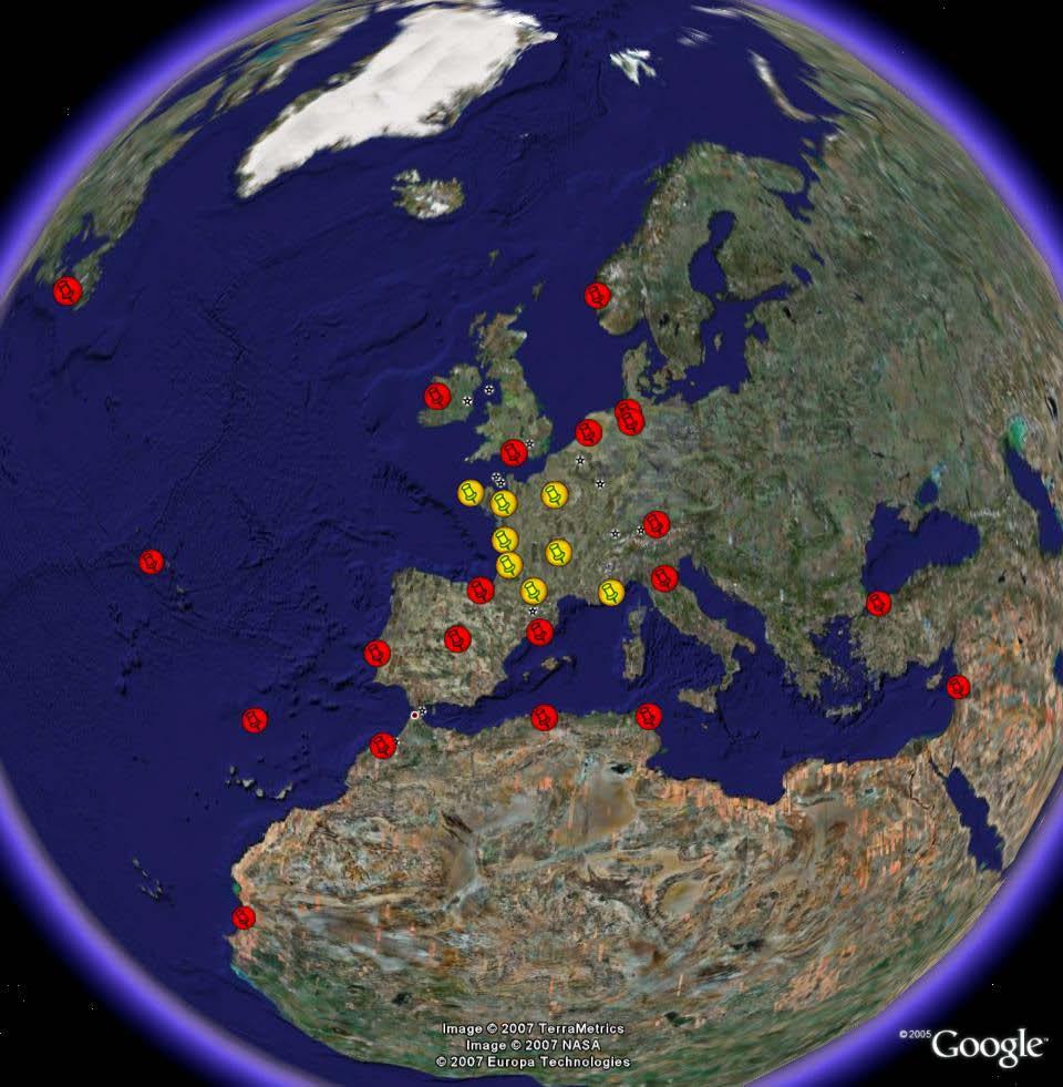
8 Softwares around the world 8
9 Development of scientific equipment Scope Development of equipment for ships and underwater vehicles Based on Research and Development Integration on ships Pool test of acoustic systems Technical fields some examples Mapping multibeam echosounder Fishing multibeam & single beam echosounders Subbottom profiler Seismic system (High Resolution, Very High Resolution, 2D and 3D, ) Oceanographic fields : geoscience, halieutic, physical oceanography, environment, sedimentology 9


")
")
10 Acoustic platform of R/V Thalassa for fishery applications Simrad ER60 (single beam) Simrad ME70 (multibeam) Simrad EM 850 (bathy/imagery) 10


11 Project example Scientific equipement (2) Subbottom profiler for ROV and AUV Particularities : BF / 6000 m / weight and volume Vertical resolution : ~ 25 cm Max Penetration : ~ 50 m 11


 AUV AsterX")
12 Project example Scientific equipment (3) Multibeam echo sounder Bathymetric Victor toolsled ( ) AUV AsterX ( ) Pourquoi pas? R/V 12
 Seismic deep")

13 Project example Scientific equipment (4) Seismic deep tow vehicle SYSIF Seismic [250, 1000 Hz] [650, 2200 Hz] 13

![2 MHz] Length : 50 m Width : 13 m Depth : 10/20 m Frequency range : [1 khz, 1.](/docs-images/76/73882119/images/14-2.jpg "2 MHz] Measurements : directivity ; frequency answer; sensitivity Customers :")
14 Electro-acoustic measurement Acoustic basin Pool test Length : 4 m Width : 2.5 m Depth : 2 m Frequency range : [8 khz, 1.2 MHz] Length : 50 m Width : 13 m Depth : 10/20 m Frequency range : [1 khz, 1.2 MHz] Measurements : directivity ; frequency answer; sensitivity Customers : IFREMER project, scientific community, industrials 14
15 Specialities and contacts Scientific softwares : JM Sinquin Network and hardware on ships : Armel Rue Video and telecommunications on ships : Guillaume Clodic Ship architecture, scientific rooms :Olivier Lefort,Sébastien Dupont,Sarah Boucard Scientific equipment on ships : Henri Floc h Ship sailing equipement, DP : Henri Floch Multibeam echosounders : Hervé Bisquay Fishing echosounders : Valérie Mazauric Underwater system deployment : Marc Nokin Kullenberg coring, winch and cable : Loic Dussud Seismic system and quality control : Bruno Marsset, Yannick Thomas Transducers & measurement : Yves Le Gall Sonar data treatment and expertise : X.Lurton 15

16 R&D - SonarScope Software for post-treatment of signal, datas, images from bathymetric sonars and associated sensors Multi layer approach : bathymetry, reflectivity, angles Tool box for specific treatment, routile exploitation and quality control 16

![[220, 1000 Hz] Immersion : 6000 m [650, 2200 Hz] Immersion :](/docs-images/76/73882119/images/17-4.jpg "6000 m [1.8, 5 khz] Immersion : 6000 m [1.8, 5.3 khz] Sondeur de coque 17")
17 R&D - Development of transducers & antennas TBF Seismic Sediment echo sounders HR VH R AUV, ROV Suroît & Pp? [220, 1000 Hz] Immersion : 6000 m [650, 2200 Hz] Immersion : 6000 m [1.8, 5 khz] Immersion : 6000 m [1.8, 5.3 khz] Sondeur de coque 17
AUVs for oceanographic science at IFREMER, project progress and operational feedback
 AUVs for oceanographic science at IFREMER, project progress and operational feedback Jan Opderbecke Jean-Marc Laframboise Jan.Opderbecke@ifremer.fr jmlaframboise@ise.bc.ca IFREMER ISE Research Ltd Department
IFREMER, Department of Underwater Systems, Toulon, France. L u c i e Somaglino, P a t r i c k J a u s s a u d, R o main P i a s co, E w e n Raugel
 F i r s t s e a t r i a l s w i t h E M 2 0 4 0 m u l t i b e a m s o u n d e r i n n o v a t i v e i n t e g r a t i o n o n H y b r i d R O V A r i a n e IFREMER, Department of Underwater Systems, Toulon,
BOTTOM MAPPING WITH EM1002 /EM300 /TOPAS Calibration of the Simrad EM300 and EM1002 Multibeam Echo Sounders in the Langryggene calibration area.
 BOTTOM MAPPING WITH EM1002 /EM300 /TOPAS Calibration of the Simrad EM300 and EM1002 Multibeam Echo Sounders in the Langryggene calibration area. by Igor Kazantsev Haflidi Haflidason Asgeir Steinsland Introduction
141 cruise days 3100 researcher days 68 researchers 32 international 15 institutes 10 countries
 N-ICE2015 Norwegian Young Sea ICE cruise 2015 141 cruise days 3100 researcher days 68 researchers 32 international 15 institutes 10 countries Kronprins Haakon Then and now Fincantieri Hull fabrication
Advantages of Using Combined Bathymetry and Side Scan Data in Survey Processing T.M. Hiller, L.N. Brisson
 Advantages of Using Combined Bathymetry and Side Scan Data in Survey Processing T.M. Hiller, L.N. Brisson EdgeTech, West WareHam MA, USA EdgeTech 6205 Combined Bathymetric and Side Scan Sonar EdgeTech
Inmartech October All Seasons Hotel, Toulon, France. wwz.ifremer.fr/inmartech08. Programme. ProgrammeInmartech08V6.
 Inmartech 08 8 10 October 2008 - All Seasons Hotel, Toulon, France wwz.ifremer.fr/inmartech08 Programme ProgrammeInmartech08V6.xls page 1/7 Tuesday 7 October 2008 17:30 Transportation by bus from Toulon-Hyères
Malta Survey activities
 Malta Survey activities Malta 19 September 2016 L. Facchin OGS National Institute of Oceanography and Experimental Geophysics Offshore Multibeam (MBES) Sub bottom profiling (SBP: Chirp or Boomer) Multichannel
APPLICATION OF SOUND PROPAGATION (IN THE PERSIAN GULF AND OMAN SEA)
") APPLICATION OF SOUND PROPAGATION (IN THE PERSIAN GULF AND OMAN SEA) Seyed Majid Mosaddad Department of Physics, Shoushtar Branch, Islamic Azad University, Shoushtar, Iran Email: mosaddad5@gmail.com Abstract
APPLICATION OF SOUND PROPAGATION (IN THE PERSIAN GULF AND OMAN SEA) Seyed Majid Mosaddad Department of Physics, Shoushtar Branch, Islamic Azad University, Shoushtar, Iran Email: mosaddad5@gmail.com Abstract
Regional Hydrographic Research, Studies & Projects
 Regional Hydrographic Research, Studies & Projects Support from Unique Maritime Group A. Sharad Kumar Regional Manager - UMG RSAHC5 Riyadh, 6 th March 2013 1. Introduction to UMG 2. Group Competencies
Emerging Subsea Networks
 THE FUTURE OF MARINE SURVEY APPLICATIONS FOR SUBMARINE CABLES Ryan Wopschall (Fugro) Email: rwopschall@fugro.com Fugro Pelagos, Inc. - 3574 Ruffin Road, San Diego, California 92123 USA Abstract: New advances
BACKGROUND TO STUDY CASE
 BACKGROUND TO STUDY CASE German Aerospace Center (DLR) is using Andøya Rocket Range for a sounding rocket campaign. On 27th October 2005 a 300 kg payload (SHEFEX) was launched Due do a technical problems
Utilizing Vessel Based Mobile LiDAR & Bathymetry Survey Techniques for Survey of Four Southern California Breakwaters
 Utilizing Vessel Based Mobile LiDAR & Bathymetry Survey Techniques for Survey of Four Southern California Breakwaters Western Dredging Association: Pacific Chapter September 2012 Insert: Pipe Location
Potential applications of AUVs and Gliders in Offshore Windfarm Site Surveys
 Potential applications of AUVs and Gliders in Offshore Windfarm Site Surveys Dr James Hunt (National Oceanography Centre, Southampton) MREKE Internship in partnership with MARS at NOCS Introduction to
Institute of Marine Research
 Institute of Marine Research CRUISE REPORT NO. ** R/V G.O. Sars Cruise No. 2005108 9 th June 24 th June 2005 Coral survey off Northern Norway Principal Scientist J. H. Fosså 2005 Benthic Habitat Research
Robin J. Beaman. School of Earth and Environmental Sciences, James Cook University, Cairns, Qld 4870, Australia.
 Robin J. Beaman School of Earth and Environmental Sciences, James Cook University, Cairns, Qld 4870, Australia. Email: robin.beaman@jcu.edu.au Seminar to SSSI Qld Hydrography Coping with Nature, Brisbane,
Cruise Report. Field Oceanography. Team 5, Leg 3
 Cruise Report Field Oceanography Team 5, Leg 3 Submitted by: Lina Stolze Allison Kennedy Madlena Hukobyan Peter Hülse Date: October 27, 2008 1. Objectives The fieldwork was part of a field oceanography
An Integrated Marine Gradiometer Array System (MGA)
") An Integrated Marine Gradiometer Array System (MGA) For Detection and Location of Chemical and Conventional UXO/MEC in Shallow to Deep Marine and Freshwater Environments Introduction Tetra Tech EC, Inc.
An Integrated Marine Gradiometer Array System (MGA) For Detection and Location of Chemical and Conventional UXO/MEC in Shallow to Deep Marine and Freshwater Environments Introduction Tetra Tech EC, Inc.
NUI Overview. Mike Jakuba Woods Hole Oceanographic Institution
 NUI Overview Mike Jakuba Woods Hole Oceanographic Institution Optics Co-Registered Multibeam Fluorometry C. Katlein (AWI) Katlein et. Al, 2015, JGR Still-Camera S. Laney (WHOI) H.Singh (WHOI) 2.5m NUI
Vieques Underwater Demonstration Project
 Vieques Underwater Demonstration Project NOAA Office of Response and Restoration National Ocean Service 2006-2007 2007 University of New Hampshire Joint Hydrographic Center 2006 Science Application International
Autosub6000. Results of its Engineering Trials and First Science Missions
 Autosub6000 Results of its Engineering Trials and First Science Missions Stephen McPhail, Maaten Furlong, Veerle Huvenne, Peter Stevenson, Miles Pebody, James Perrett NOC, Southampton, UK Objectives of
THE POURQUOI PAS?, AN INNOVATIVE OCEANOGRAPHIC VESSEL. By : Olivier LEFORT. Marc NOKIN
 THE POURQUOI PAS?, AN INNOVATIVE OCEANOGRAPHIC VESSEL By : Olivier LEFORT Pourquoi pas? Project Leader Ifremer Marc NOKIN Implementation Manager for Submersible Devices Ifremer 1 I. THE POURQUOI PAS?,
High Definition Laser Scanning (HDS) Underwater Acoustic Imaging and Profiling
 Underwater Acoustic Imaging and Profiling") High Definition Laser Scanning (HDS) Underwater Acoustic Imaging and Profiling Images at Depth: The Use of Acoustic Imaging on Large River Crossings A Case Study AGENDA Background of project Review of
High Definition Laser Scanning (HDS) Underwater Acoustic Imaging and Profiling Images at Depth: The Use of Acoustic Imaging on Large River Crossings A Case Study AGENDA Background of project Review of
from ocean to cloud PARAMETRIC SUB-BOTTOM PROFILER, A NEW APPROACH FOR AN OLD PROBLEM
 PARAMETRIC SUB-BOTTOM PROFILER, A NEW APPROACH FOR AN OLD PROBLEM Geoff Holland, Alcatel-Lucent Submarine Networks Geoff.holland@alcatel-lucent.com Alcatel-Lucent Submarine Networks Ltd, Christchurch Way,
Design and Planning Considerations For a Seabed Survey
 Design and Planning Considerations For a Seabed Survey Vera Quinlan Hydrographer & Data Processor Seabed Survey Overview Survey Platform - What boat do I use? Survey Area / depth of water / objective &
Innovation and operation with robotized underwater systems
 Please note that this is an author-produced PDF of an article accepted for publication following peer review. The definitive publisher-authenticated version is available on the publisher Web site Journal
Acoustic Pipeline Inspection Mind The Gap
 Acoustic Pipeline Inspection Mind The Gap Mike Liddell Chief Surveyor, Fugro Survey Limited UUVS @ Oceanology 2012 13 th March 2012 Contents Menu Introduction to Pipeline Inspection The Current Toolkit
The MEDUSA Deep Sea and FUSION AUVs:
 1 The MEDUSA Deep Sea and FUSION AUVs: When Research and business get together EMRA 2017, Girona, Spain 15 May 2017 Bruno Cardeira/IST Deep Ocean Exploration -Why the effort? Portugal Exclusive Economic
Polar Research Vessel Operational Requirements and Summary of Technical Studies
 Polar Research Vessel Operational Requirements and Summary of Technical Studies Presentation to UNOLS by Jim St John Science and Technology Corporation - Polar Technology Office Why a New Antarctic Research
14/10/2013' Bathymetric Survey. egm502 seafloor mapping
 egm502 seafloor mapping lecture 10 single-beam echo-sounders Bathymetric Survey Bathymetry is the measurement of water depths - bathymetry is the underwater equivalent of terrestrial topography. A transect
NOAA s Underwater UXO Demonstration Projects Vieques Island, Puerto Rico
 NOAA s Underwater UXO Demonstration Projects Vieques Island, Puerto Rico Vieques Restoration Advisory Board Meeting May 7, 2008 Jason Rolfe NOAA s Office of Response & Restoration NOAA s Underwater UXO
Examples of Carter Corrected DBDB-V Applied to Acoustic Propagation Modeling
 Naval Research Laboratory Stennis Space Center, MS 39529-5004 NRL/MR/7182--08-9100 Examples of Carter Corrected DBDB-V Applied to Acoustic Propagation Modeling J. Paquin Fabre Acoustic Simulation, Measurements,
Concarneau, June 23 rd The Moroccan Royal Navy entrusted PIRIOU with the building of Hydro-Oceanographic and Multi-Missions vessel
 P RESS RELEASE Concarneau, June 23 rd 2016 The Moroccan Royal Navy entrusted PIRIOU with the building of Hydro-Oceanographic and Multi-Missions vessel PIRIOU has just recorded a new order from the Moroccan
RAMSTM. 360 Riser and Anchor-Chain Integrity Monitoring for FPSOs
 RAMS 360 Riser and Anchor-Chain Integrity Monitoring for FPSOs Introduction to RAMS Tritech s RAMS is a 360 anchor-chain and riser integrity monitoring system for Floating Production Storage and Offloading
An accident at sea, such as an
 Littoral water survey and security Surveying by Claude Cazaoulou, ECA More than 90% of international commercial exchange and 70% of annual world oil consumption are transported by sea. Millions of people
New Norwegian icegoing reseach vessel ERVO 2009
 New Norwegian icegoing reseach vessel ERVO 2009 First and only Norwegian purpose built icegoing research vessel Feasibility study Develop a proposal for a replacement vessel for Lance and Jan Mayen Renewal-plan
Model-based Adaptive Acoustic Sensing and Communication in the Deep Ocean with MOOS-IvP
 Model-based Adaptive Acoustic Sensing and Communication in the Deep Ocean with MOOS-IvP Henrik Schmidt & Toby Schneider Laboratory for Autonomous Marine Sensing Systems Massachusetts Institute of technology
Autonomous Underwater Vehicles Explorer Class
 Autonomous Underwater Vehicles Explorer Class Neil Bose Professor of Maritime Hydrodynamics Manager, Australian Maritime Hydrodynamics Research Centre AMC National Centre for Maritime Engineering and Hydrodynamics
Optimizing Sound Speed Profiling to Meet TPU Requirements using a CAST Gauge
 Optimizing Sound Speed Profiling to Meet TPU Requirements using a CAST Gauge (Computer Aided Sound speed Technology) Derrick R. Peyton, Steven Smyth, Arnold Furlong ODIM Brooke Ocean Jonathan Beaudoin
MODEL DIGITAL ALTIMETER USER'S MANUAL 330KHZ, 1000M DEPTH RATED 0.5 TO 100FT (0.15 TO 30M) OPERATING RANGE SERIAL OUTPUT
 OPERATING RANGE SERIAL OUTPUT") MODEL 863-000-200 DIGITAL ALTIMETER USER'S MANUAL 330KHZ, 1000M DEPTH RATED 0.5 TO 100FT (0.15 TO 30M) OPERATING RANGE SERIAL OUTPUT DOCUMENT NO. 430-017C April 14, 2005 S/N IMAGENEX TECHNOLOGY CORP. 209-1875
MODEL 863-000-200 DIGITAL ALTIMETER USER'S MANUAL 330KHZ, 1000M DEPTH RATED 0.5 TO 100FT (0.15 TO 30M) OPERATING RANGE SERIAL OUTPUT DOCUMENT NO. 430-017C April 14, 2005 S/N IMAGENEX TECHNOLOGY CORP. 209-1875
CONSTRUCTION OF LNG RECEIVING TERMINAL ON THE SAINT LAWRENCE TIDAL CURRENT CONDITIONS IN THE LEVIS AREA
 RABASKA PROJECT CONSTRUCTION OF LNG RECEIVING TERMINAL ON THE SAINT LAWRENCE TIDAL CURRENT CONDITIONS IN THE LEVIS AREA FINAL REPORT MARCH 2006 N/Réf. : 24237.360 3075, ch. des Quatre-Bourgeois Sainte-Foy
Update on Canadian Research Vessels Ship Procurement Projects
 Update on Canadian Research Vessels Ship Procurement Projects 28 th International Research Ship Operators Meeting (IRSO) La Jolla, California October 2012 Jennifer Vollrath 1 Outline National Ship Building
Specifications for Synchronized Sensor Pipe Condition Assessment (AS PROVIDED BY REDZONE ROBOTICS)
") Specifications for Synchronized Sensor Pipe Condition Assessment (AS PROVIDED BY REDZONE ROBOTICS) A. Scope of Work The work covered by these specifications consists of furnishing all materials, labor,
Specifications for Synchronized Sensor Pipe Condition Assessment (AS PROVIDED BY REDZONE ROBOTICS) A. Scope of Work The work covered by these specifications consists of furnishing all materials, labor,
Recommended operating guidelines (ROG) for sidescan Sidescan sonar ROG in wrapper.doc English Number of pages: 9 Summary:
 for sidescan Sidescan sonar ROG in wrapper.doc English Number of pages: 9 Summary:") Title: Author(s): Document owner: Recommended operating guidelines (ROG) for sidescan sonar Dave Long (BGS) Dave Long (BGS) Reviewed by: Janine Guinan (MI) 07/09/07 Workgroup: MESH action: 2.1 Version:
Title: Author(s): Document owner: Recommended operating guidelines (ROG) for sidescan sonar Dave Long (BGS) Dave Long (BGS) Reviewed by: Janine Guinan (MI) 07/09/07 Workgroup: MESH action: 2.1 Version:
MODEL ANALOG ALTIMETER USER'S MANUAL 330KHZ, 1000M DEPTH RATED 0.2 TO 100FT OPERATING RANGE ANALOG OUTPUT
 MODEL 862-000-200 ANALOG ALTIMETER USER'S MANUAL 330KHZ, 1000M DEPTH RATED 0.2 TO 100FT OPERATING RANGE ANALOG OUTPUT DOCUMENT NO. 430-007H September 20, 2005 S/N IMAGENEX TECHNOLOGY CORP. 209-1875 BROADWAY
Archimer
 Please note that this is an author-produced PDF of an article accepted for publication following peer review. The definitive publisher-authenticated version is available on the publisher Web site Sea Technology
UNDERWATER SERVICES COMPANY PROFILE
 UNDERWATER SERVICES COMPANY PROFILE irov Underwater Services is an Italian Independent H i g h l y S p e c i a l i z e d C o m p a n y p r o v i d i n g underwater technology and ROV assistance to Salvage
High Frequency Acoustical Propagation and Scattering in Coastal Waters
 High Frequency Acoustical Propagation and Scattering in Coastal Waters David M. Farmer Graduate School of Oceanography (educational) University of Rhode Island Narragansett, RI 02882 phone: (401) 874-6222
Noise Experiment #2. Marine Physical Laboratory Scripps Institution of Oceanography La Jolla, CA February 22 February 2010
 Noise Experiment #2 Marine Physical Laboratory Scripps Institution of Oceanography La Jolla, CA 92093-0701 16 February 22 February 2010 1. Objective The objective of the noise experiment is to observe
Not to be cited without prior reference to the author
 In-situ measurements of the individual acoustic backscatter of European anchovy (Engraulis encrasicolus) and sardine (Sardina Pilchardus), with concurrent optical identification. Mathieu Doray, Laurent
Chapter 9: Sea operations
 Chapter 9: Sea operations ANTARES takes advice from IFREMER for the sea operations, which concern the installation and recovery of the different components of the detector : Junction Box, Strings, Interconnecting
Panel Discussion on unmanned Hydrography
 Panel Discussion on unmanned Hydrography Overview Why bother General Types Autonomous Underwater Vehicle (AUV) Remotely Operated Vehicle (ROV) Unmanned Surface Vessels (USV) TerraSond s Experiences AUV
An effective approach for wide area detailed seabed mapping
 An effective approach for wide area detailed seabed mapping Busan, 15th November 2017 11/15/2017 1 Ocean Infinity & Partner Proving a comprehensive seabed exploration system for water depth down to 6000
 Side 1 av 7 Home > Diving Equipment > Side Scan Sonar > Imagenex Sidescan Sonar > Yellowfin Yellowfin Sidescan Sonar Magnetometers Side Scan Sonar Cameras Storm Cases Interferometric & Sidescan Equipment
Background Paper: Surveys. Nord Stream 2 AG Sep-17
 Nord Stream 2 AG Sep-17 Table of Contents Introduction... 3 Advanced Technology... 4 Survey Stages... 4 2 Introduction Survey operations are the cornerstone of massive international infrastructure projects
R/V Kilo Moana EM122 Multibeam Echosounder Review KM August 9-13, 2015
 R/V Kilo Moana EM122 Multibeam Echosounder Review KM1514 - August 9-13, 2015 Report prepared by: Paul Johnson and Kevin Jerram University of New Hampshire Center for Coastal and Ocean Mapping/Joint Hydrographic
The Challenge of Underwater Gas (Leakage) Monitoring
 Monitoring") The Challenge of Underwater Gas (Leakage) Monitoring Ingo Möller Kai Spickenbom, Volker Böder, Martin Krüger IEAGHG workshop on Natural Releases of CO2, Maria Laach, November 2 4, 2010 Challenges of underwater
The Challenge of Underwater Gas (Leakage) Monitoring Ingo Möller Kai Spickenbom, Volker Böder, Martin Krüger IEAGHG workshop on Natural Releases of CO2, Maria Laach, November 2 4, 2010 Challenges of underwater
Survey solutions. catalogue DEEP INSIGHT. SHARPER SENSES.
 Survey solutions catalogue DEEP INSIGHT. SHARPER SENSES. i stands for Imagination. «X» is the excellence for which we strive. Our technologies guarantee superiority in all senses - navigating from the
Meeting the Challenges of the IHO and LINZ Special Order Object Detection Requirements
 Meeting the Challenges of the IHO and LINZ Special Order Object Detection Requirements Erik Hammerstad Kongsberg Maritime P. O. Box 111, N-3191 Horten, Norway erik.oscar.hammerstad@kongsberg.com Abstract
Sonar Bathymetry: Waquoit Bay NERR
 Sonar Bathymetry: Waquoit Bay NERR Determining the Functional Shallow Water Limitation for an Arrival Based Sonar Frederick A. Hegg Teledyne Benthos, Inc. 49 Edgerton Drive North Falmouth, MA 02556 fhegg@teledyne.com
MARINE NAVIGATION LESSON PLAN See That Sound?
 Marine Navigation Hydrography Lesson Plan MARINE NAVIGATION LESSON PLAN See That Sound? Theme Hydrographic Survey Links to Overview Essays and Resources Needed for Student Research http://oceanservice.noaa.gov/topics/navops/hydrosurvey/
SHUTTLE-SUBs ALL OCEANS Engineering Ltd
 SUK Underwater Vehicles Conference 21.11.17 SHUTTLE-SUBs AC-ROV 3000m Fly-out System Introduced in 2011 MAC-ROV 6000m Fly-out System (2017) 6000m, 4k and HD cameras, SM fibre telemetry Expandable architecture,
Failure of Wide Bay Pipeline in the Burnett River
 APGA Paper Date: 29 August 2015 Subject: Risk Mitigation for Trench Pipeline Under Shallow River Crossings Prepared by: Derek Boo Manager Planning and Engineering Company: APA Group Background: Beginning
The Evolution of an Autonomous Unmanned Surface Vessel and Software for Hydrographic Survey
 The Evolution of an Autonomous Unmanned Surface Vessel and Software for Hydrographic Survey Paul Donaldson In 2017, Leidos, Inc. participated in both the Gulf of Mexico Unmanned Systems Operational Demonstration
Bedform Parameterization and Object Detection from Sonar Data- Application of Finger Print Algorithms
 DISTRIBUTION STATEMENT A. Approved for public release; distribution is unlimited. Bedform Parameterization and Object Detection from Sonar Data- Application of Finger Print Algorithms PI: Arthur C. Trembanis
Hydro-Thermal Vent Mapping with Multiple AUV's AZORES-2001
 Hydro-Thermal Vent Mapping with Multiple AUV's AZORES-2001 Anthony J. Healey David B. Marco Center for Autonomous Underwater Vehicle Research Naval Postgraduate School Monterey, CA phone: (831)-656-3462
ICES Working Group on the assessment of Mackerel, Horse Mackerel, Sardine and Anchovy. Vigo, 5-15 September 2005 Working Document
 ICES Working Group on the assessment of Mackerel, Horse Mackerel, Sardine and Anchovy. Vigo, 5-15 September 25 Working Document Direct assessment of anchovy by the PELGAS5 acoustic survey Jacques Massé
CODEVINTEC. All the sonars you need, in one place
 45 27 39.384 N 9 07 30.145 E All the sonars you need, in one place Teledyne RESON, BlueView and Odom Hydrographic are part of the Teledyne Marine Acoustic Imaging Group (TMAIG). With more than 35 years
RR10106 Cruise Plan ITOP Mooring Recovery and PhilSea10 Seaglider Operation (R/V Revelle November 6-26, 2010)
") RR10106 Cruise Plan ITOP Mooring Recovery and PhilSea10 Seaglider Operation (R/V Revelle November 6-26, 2010) Chief Scientist: Ren-Chieh Lien, Applied Physics Lab, University of Washington Co-Chief Scientist:
RR10106 Cruise Plan ITOP Mooring Recovery and PhilSea10 Seaglider Operation (R/V Revelle November 6-26, 2010) Chief Scientist: Ren-Chieh Lien, Applied Physics Lab, University of Washington Co-Chief Scientist:
Product Description EM 3002
 Product Description EM 3002 Multibeam echo sounder Kongsberg EM 3002 Multibeam echo sounder Product description 855-164929 / Rev.A Note Kongsberg Maritime AS makes every effort to ensure that the information
History/Explorers/Expeditions/Technology Webquest!
 Name Block History/Explorers/Expeditions/Technology Webquest! http://www.divediscover.whoi.edu/history-ocean/21st.html Click on: History of Oceanography (on the left side of the page) 1. Oceanography may
MOOS IvP Helm Based Simulations of Collision Avoidance by an Autonomous Surface Craft Performing Repeat-Transect Oceanographic Surveys
 MOOS IvP Helm Based Simulations of Collision Avoidance by an Autonomous Surface Craft Performing Repeat-Transect Oceanographic Surveys Michael A. Filimon Dept. of Ocean Engineering Daniel L. Codiga Grad.
Copicut Reservoir Sidescan Sonar. Fall River, MA May 7, 2013
 Copicut Reservoir Sidescan Sonar Fall River, MA May 7, 2013 1 Table of Contents Section 1: Mission Overview... 3 Background... 3 Vehicle General Information... 3 Vehicle Mission Details... 4 Area of Operation...
Evaluation of the Klein HydroChart 3500 Interferometric Bathymetry Sonar for NOAA Sea Floor Mapping
 Evaluation of the Klein HydroChart 3500 Interferometric Bathymetry Sonar for NOAA Sea Floor Mapping Yuhui Ai, Straud Armstrong and Dean Fleury L-3 Communications Klein Associates, Inc. 11 Klein Dr. Salem,
CCGS Amundsen: A New Mapping Platform for Canada s North.
 CCGS Amundsen: A New Mapping Platform for Canada s North. Jason Bartlett Canadian Hydrographic Service Jonathan Beaudoin Ocean Mapping Group John Hughes Clarke Chair, Ocean Mapping Group Introduction In
Cruise Plan for QPE (R/V Revelle Sept/ 12-16, 2009)
") Cruise Plan for QPE (R/V Revelle Sept/ 12-16, 2009) Objectives In this cruise we will recover six subsurface ADCP/TC moorings (Lien), five restrained ADCP (Centurioni), and perform shipboard ADCP, Revelle
Cruise Plan for QPE (R/V Revelle Sept/ 12-16, 2009) Objectives In this cruise we will recover six subsurface ADCP/TC moorings (Lien), five restrained ADCP (Centurioni), and perform shipboard ADCP, Revelle
Scottish Hydro Electric Power Distribution Operation, Inspection, Maintenance and Decommissioning Strategy Bute Cumbrae Cable Replacement
 SHEPD Section ID 154 Scottish Hydro Electric Power Distribution Operation, Inspection, Maintenance and Decommissioning Strategy Bute Cumbrae Cable Replacement Contents Definitions and Abbreviations...
Location: Barkley Canyon Date: September 9, 2013 Constraints: none
 Page 1 of 11 DIVE PLAN R1650 Location: Barkley Canyon Date: September 9, 2013 Constraints: none Objectives Deploy POD 1 autonomous CTD Survey POD 3 for sediment enrichment sites; deposit cages; collect
Sea Search Operations AF 447 A February 2010
 Sea Search Operations AF 447 A330-203 17 February 2010 Search Phases Phase 1 : Acoustic search for Underwater Locator Beacons (10 June to 10 July in the search zone) Phase 2 : Search for the wreckage using
Sontek RiverSurveyor Test Plan Prepared by David S. Mueller, OSW February 20, 2004
 Sontek RiverSurveyor Test Plan Prepared by David S. Mueller, OSW February 20, 2004 INTRODUCTION Sontek/YSI has introduced new firmware and software for their RiverSurveyor product line. Firmware changes
R/V Bat Galim EM302 & EM2040 Multibeam Echosounder System Review January 31 February 4, 2016
 R/V Bat Galim EM302 & EM2040 Multibeam Echosounder System Review January 31 February 4, 2016 Report prepared by: Paul D. Johnson University of New Hampshire Center for Coastal and Ocean Mapping / Joint
SEAHORSES and SUBMARINES Testing transformational capabilities with modern UUVs at NAVOCEANO by Craig A. Peterson and Martha E. M.
 SEAHORSE engineers work on a module inside one AUV of the SEAHORSE 2 bays. SEAHORSE 2 is being prepared for launch from the IC-508 AUV Support Vessel. SEAHORSES and SUBMARINES Testing transformational
Remotely Operated Vehicles for Restricted Access Hydrographic Surveys
 Products & Services Remotely Operated Vehicles for Restricted Access Hydrographic Surveys Mathew Cook The technological advancements in the field of ROV have greatly simplified the inspection process in
R/V HUGH R. SHARP University of Delaware 2016
 R/V HUGH R. SHARP R/V HUGH R. SHARP University of Delaware 2016 GENERAL DESCRIPTION: The R/V HUGH R. SHARP is an acoustically quiet, state of the art, general-purpose, regional class research vessel operated
Marine Towed Array Surveys of Ostrich Bay, Lake Erie and Puerto Rico.
 Marine Towed Array Surveys of Ostrich Bay, Lake Erie and Puerto Rico. Chet Bassani, Nagi Khadr, Chris Gibson and Jim McDonald Advanced Sensors and Analysis Div., SAIC Cary, NC Marine Towed Array (MTA)
Advanced PMA Capabilities for MCM
 Advanced PMA Capabilities for MCM Shorten the sensor-to-shooter timeline New sensor technology deployed on off-board underwater systems provides navies with improved imagery and data for the purposes of
DIRECT INVENTORY TAKING OF UNDERWATER OBJECTS USING A HANDHELD GPS RECEIVER
 DIRECT INVENTORY TAKING OF UNDERWATER OBJECTS USING A HANDHELD GPS RECEIVER ABSTRACT Dariusz Popielarczyk Chair of Satellite Geodesy and Navigation Warmia and Mazury University in Olsztyn The paper presents
SeaBat T50-R Product Description
 Ultra-High Resolution Multibeam Echosounder March 2017 PD17419-3 Table of Contents SYSTEM OVERVIEW... 5 Introduction... 5 Typical Applications... 5 Warranty... 5 SYSTEM ARCHITECTURE... 6 SeaBat T50-R...
Scanning Sonar and ROV Operations. For Underwater SAR Imaging Applications
 Scanning Sonar and ROV Operations For Underwater SAR Imaging Applications This training module provides information specific to integrating scanning sonar onto an ROV platform and fundamentals in using
DEPARTMENT FOR ENVIRONMENT, FOOD AND RURAL AFFAIRS CEFAS, LOWESTOFT LABORATORY, SUFFOLK, ENGLAND
 DEPARTMENT FOR ENVIRONMENT, FOOD AND RURAL AFFAIRS CEFAS, LOWESTOFT LABORATORY, SUFFOLK, ENGLAND 2005 RESEARCH VESSEL PROGRAMME PROGRAMME: RV CEFAS ENDEAVOUR: CRUISE 07/05 STAFF: D. Righton (SIC), S. Mackinson
Compact Light Weight RC Boat for Hydrographic Surveys on Dams, Creeks, Rivers, storm water retention pits and other waterways.
 Accura Hydrographic RC Survey Boat Compact Light Weight RC Boat for Hydrographic Surveys on Dams, Creeks, Rivers, storm water retention pits and other waterways. Utilises Sounder & Transducer from CEE
South Bay Coastal Ocean Observing System California Clean Beaches Initiative
 South Bay Coastal Ocean Observing System California Clean Beaches Initiative Quarterly Report September 2003 to City of Imperial Beach Eric Terrill 1 1 Scripps Institution of Oceanography, University of
TRIDENT progress. 2nd I-AUV TRIDENT School Soller (Mallorca Spain) Marine Robot and Dexterous Manipulatin for Enabling Multipurpose
 Marine Robot and Dexterous Manipulatin for Enabling Multipurpose") Dexterous Manipulatin for Enabling Multipurpose Intevention Missions TRIDENT progress 2nd I-AUV TRIDENT School Soller (Mallorca Spain) OVERVIEW FIELD TESTING INTEGRATION-1 (UdG, 3-7 SET 2012) INTEGRATION-2
Dexterous Manipulatin for Enabling Multipurpose Intevention Missions TRIDENT progress 2nd I-AUV TRIDENT School Soller (Mallorca Spain) OVERVIEW FIELD TESTING INTEGRATION-1 (UdG, 3-7 SET 2012) INTEGRATION-2
Cruise Report Towed ADCP Bay of Biscay R/V Pelagia cruise 64PE April 2005 Texel - Vigo
 Reference: van Haren, H., 2005. Towed ADCP- Bay of Biscay: R/V Pelagia cruise 64PE235, 20-27 April 2005, NIOZ, 15 pp. Cruise Report Towed ADCP Bay of Biscay R/V Pelagia cruise 64PE235 20-27 April 2005
Isaacs Kidd Mid water Trawl
 2007 Standard Operating Procedures of Isaacs Kidd Mid water Trawl NAKARET YASOOK APINANT TARADOL TAWEESAK TIMKRUB NARONG REUNGSIVAKUL SOMBOON SIRIRAKSOPHON SOUTHEAST ASIAN FISHERIES DEVELOPMENT CENTER
UTEC Survey Pipeline Inspection Using Low Logistic AUV June 2016
 SUCCESS YOU CAN MEASURE UTEC Survey Pipeline Inspection Using Low Logistic AUV June 2016 Chris Erni Product Line Manager E T H I C S P E R F O R M A N C E E X C E L L E N C E P E O P L E GLOBAL FOOTPRINT
Application for Consent to Conduct Marine Scientific Research. F Internal Waves in Straits (IWISE) Institution Contact Information Director
 Institution Contact Information Director") 1. General Information 1.1 Reference ID: Application for Consent to Conduct Marine Scientific Research Application number: Project name: F2010-111 Internal Waves in Straits (IWISE) 1.2 Sponsoring institution(s):
1. General Information 1.1 Reference ID: Application for Consent to Conduct Marine Scientific Research Application number: Project name: F2010-111 Internal Waves in Straits (IWISE) 1.2 Sponsoring institution(s):
Challenges in determining water surface in airborne LiDAR topobathymetry. Amar Nayegandhi, Dewberry 15 th Annual JALBTCX Workshop, June 11 th 2014
 Challenges in determining water surface in airborne LiDAR topobathymetry Amar Nayegandhi, Dewberry 15 th Annual JALBTCX Workshop, June 11 th 2014 Why topobathy LiDAR? Complements acoustic (multi-beam sonar)
High Precision Hydrography in Canada, the ST. Lawrence River Channel, HD Bathymetry, Production, Distribution and Updating
 High Precision Hydrography in Canada, the ST. Lawrence River Channel, HD Bathymetry, Production, Distribution and Updating Marc Journault Canada CHS, Louis Maltais Canada CHS, and Richard Sanfaçon Canada
Observing the behavioral response of herring exposed to mid-frequency sonar signals
 Observing the behavioral response of herring exposed to mid-frequency sonar signals Handegard 1, Nils Olav and Doksaeter 1, Lise and Godoe 1, Olav Rune and Kvadsheim 2, Petter H. 1 Institute of Marine
Natsushima Cruise Report NT Sea trial of Autonomous Underwater Vehicle. Yumeiruka around Omuro-dashi. Sagami Bay, Suruga Bay and Omuro-dashi
 Natsushima Cruise Report NT15-11 Sea trial of Autonomous Underwater Vehicle Yumeiruka around Omuro-dashi Sagami Bay, Suruga Bay and Omuro-dashi July 5, 2015 July 10, 2015 Japan Agency for Marine-Earth