EMPA 2017 How can the S-102 Bathymetric Surface Product improve safety in navigation and pilotage?
|
|
|
- Esmond Goodman
- 5 years ago
- Views:
Transcription

1 EMPA 2017 How can the S-102 Bathymetric Surface Product improve safety in navigation and pilotage? Operated by the Norwegian Mapping Authority, Hydrographic Service FREEDOM TO CHOOSE
2 Content What is the IHO S-100 product family? What is the S-102 Bathymetric Surface Product? How is the S-102 Bathymetric Surface Product produced? How can the S-102 Bathymetric Surface Product be used for improving navigational safety? What is the current status of support for the S-102 Bathymetric Surface Product?
3 IHO S-100 product family The primary goal for S-100 is to support a greater variety of hydrographic-related digital data sources, products, and customers. Will enable wider use and transfer of hydrographic data than S-57 Is aligned with a contemporary standard (ISO 19100) Use of imagery and gridded data, enhanced metadata specifications, unlimited encoding formats and a more flexible maintenance regime.
 S-102 Bathymetric Surface S-103 Sub-surface")


4 IHO S-100 product family S-101 Electronic Navigational Chart (ENC) S-102 Bathymetric Surface S-103 Sub-surface Navigation S-104 Tidal Information for Surface Navigation S-111 Surface Currents S-112 Dynamic Water Level Data S-121 Maritime Limits and Boundaries S-122 Marine Protected Areas S-123 Radio Services S-124 Navigational Warnings S-125 Navigational Services S-126 Physical Environment S-127 Traffic Management S-128 Catalogues of Nautical Products
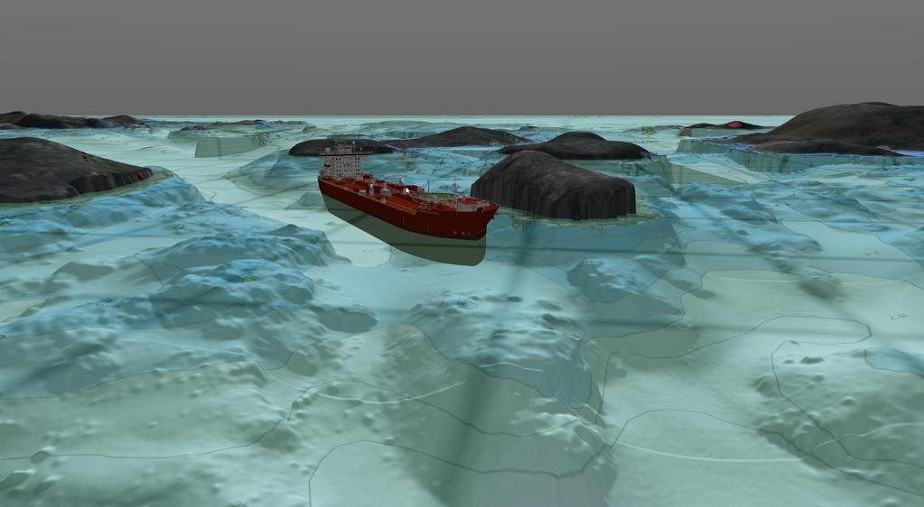
5 S-102 Bathymetric Surface Product Part of the S-100 product family A product specification for bathymetric surface data which may be used alone or as an auxiliary layer of data with an ENC. A navigation surface coverage including both depth and uncertainty. Optional tracking list of the depth changes that have been manually replaced by the hydrographer to ensure safety of navigation. Must be certified by a hydrographer using a digital signature.

6 S-102 Bathymetric Surface Product Product: High definition gridded bathymetry. Purpose: To support safe navigation as an auxiliary aid. Use: Navigation and planning: Safe depth, under keel clearance, anchorage areas, situational awareness. Innovative: Seamless calculation of depth contours Available water column by integrating tidal data. Calculation of dynamic under keel clearance

7 Production of S-102 High quality survey data necessary Same reference level as used in ENCs

8 Production of S-102 A resolution is generated in accordance with the source data. The resolution will vary with depth, type of echo sounder used and the variation in bathymetri. An algorithm is used to calculate the mean value of each cell A cell without source data will be shown as void.

9 Production of S-102 The grid creates a model of the bathymetri. A «tracking list» gives the option to overrule data in the model with manually selected depth values. Safety of Navigation: The Mean Value in the cell can be less than the shallowest value. Mean Value replaced with shallowest value.

10 Production of S-102 Statistics regarding the data set is generated: Min and max values, standard deviation. Standard Deviation: The average distance the individual depth value deviate from the calculated cell value. S-102 can be used in conjunction with other data: (ENC).

11 Paper chart Operated by the Norwegian Hydrographic Service

12 Electronic Chart ENC Operated by the Norwegian Hydrographic Service

13 ENC combined with S-102 Operated by the Norwegian Hydrographic Service
14

15 Available water column Under keel clearance Depth contours


16 S-102 value chain Data collection PRIMAR S-102 validation and distribution Commercial and National Distributors Sales Data processing S-102 production Endusers


17 PRIMAR S-102 Service display

18 S-102 the road ahead - Finish the PRIMAR service for upload, validation and distribution - New version of the standard - Data production - Development and testing of end-user systems - End-user tests
19 Thank you for your attention! Operated by the Norwegian Mapping Authority, Hydrographic Service FREEDOM TO CHOOSE
Paper for consideration by ENC Working Group. Use of AU6 ENC cells as an option for Bathymetric ENCs (benc)
") Paper for consideration by ENC Working Group Use of AU6 ENC cells as an option for Bathymetric ENCs (benc) Submitted by: Alvaro Sanchez (AHS) Executive Summary: Compilation of high density bathymetric
Paper for consideration by ENC Working Group Use of AU6 ENC cells as an option for Bathymetric ENCs (benc) Submitted by: Alvaro Sanchez (AHS) Executive Summary: Compilation of high density bathymetric
V Complying with IHO S-52/S-63/S-64
 Model FEA-2107/2807 V.06.50 Complying with IHO S-52/S-63/S-64 The software has been upgraded to V.06.50 in accordance with the IHO standards. IHO S-52 Ed. 6.1.1 Specifications for Chart Contents and Display
PORTS AUSTRALIA. PRINCIPLES FOR GATHERING AND PROCESSING HYDROGRAPHIC INFORMATION IN AUSTRALIAN PORTS (Version 1.5 November 2012)
") PORTS AUSTRALIA PRINCIPLES FOR GATHERING AND PROCESSING HYDROGRAPHIC INFORMATION IN AUSTRALIAN PORTS (Version 1.5 November 2012) PREFACE These Principles have been prepared by the Hydrographic Surveyors
PORTS AUSTRALIA PRINCIPLES FOR GATHERING AND PROCESSING HYDROGRAPHIC INFORMATION IN AUSTRALIAN PORTS (Version 1.5 November 2012) PREFACE These Principles have been prepared by the Hydrographic Surveyors
S-44 edition 5 The IHO s New Standard For Hydrographic Surveys Chris Howlett Head of Seabed Data Centre United Kingdom Hydrographic Office
 S-44 edition 5 The IHO s New Standard For Hydrographic Surveys Chris Howlett Head of Seabed Data Centre United Kingdom Hydrographic Office Chairman of IHO Working Group that created S-44 edition 5 S-44
S-102 v2.0 Status Brief
 S-102 v2.0 Status Brief S-100 TSM6 (SEP 2018) David W Brazier, US Navy Stacy Johnson, US Navy The views expressed in this article are those of the author and do not necessarily reflect the official policy
Activities of KHOA on creation of S-10X test data sets and S-100 sea trial
 Activities of KHOA on creation of S-10X test data sets and S-100 sea trial Submitted by: Executive Summary: Related Documents: Related Projects: Republic Of Korea (KHOA) KHOA has been conducting a research
DUKC Chart Overlay. Presentation to IHO TWL and DQ Working Groups Wollongong, March 2014
 DUKC Chart Overlay Presentation to IHO TWL and DQ Working Groups Wollongong, March 2014 Outline Who is OMC? DUKC description & methodology. DUKC Chart Overlay concept. Chart Overlay application example.
Minimum depth, mean depth or something in between?
 Minimum depth, mean depth or something in between? Tannaz H. Mohammadloo a, Mirjam Snellen a, Dick G. Simons a, Ben Dierikx b, Simon Bicknese b a Acoustics Group, Department of Control & Operations, Faculty
NATIONAL REPORT OF SWEDEN
 52 nd NHC Meeting NHC/52/2 E 6-8 May 2008 Norrköping NATIONAL REPORT OF SWEDEN 1. General Information The overall organisation of the Swedish Maritime Administration (SMA) is subject for changes. It is
This report summarizes the activities of Hydrographic Unit of Qatar carried out since the 6 th RSAHC meeting in February 2015.
 1. Hydrographic Unit This report summarizes the activities of Hydrographic Unit of Qatar carried out since the 6 th RSAHC meeting in February 2015. The latest update for the IHO Yearbook is the following:
Crowdsourced Bathymetry Data via Electronic Charting Systems
 Crowdsourced Bathymetry Data via Electronic Charting Systems Evan Robertson evan.robertson@noaa.gov Cooperative Institute for Research in Environmental Sciences (CIRES), University of Colorado, Boulder,
Paper for Consideration by HSSC8 Development of an Additional Bathymetry Layer standard based on S-57/S-52
 Paper for Consideration by HSSC8 Development of an Additional Bathymetry Layer standard based on S-57/S-52 Submitted by: CIRM, Germany, USA (NOAA) Executive Summary: Proposal for the standardization of
SAFETY OF NAVIGATION OPERATING ANOMALIES IDENTIFIED WITHIN ECDIS
 E 4 ALBERT EMBANKMENT LONDON SE1 7SR Telephone: +44 (0)20 7735 7611 Fax: +44 (0)20 7587 3210 SN.1/Circ.312 9 July 2012 SAFETY OF NAVIGATION OPERATING ANOMALIES IDENTIFIED WITHIN ECDIS 1 The Sub-Committee
14/10/2013' Bathymetric Survey. egm502 seafloor mapping
 egm502 seafloor mapping lecture 10 single-beam echo-sounders Bathymetric Survey Bathymetry is the measurement of water depths - bathymetry is the underwater equivalent of terrestrial topography. A transect
AHO s experience on HD bathymetric ENCs
 AHO s experience on HD bathymetric ENCs ENCWG3 Wollongong 16 18 April 2018 Alvaro Sanchez DD Charting Quality Assurance, Standards and Specifications Australian Hydrographic Office Background 2016 As part
Nautical sub-committee
 Nautical sub-committee Accomplishments, latest work and developments Capt. Pantelis Patsoulis Nautical sub-committee INTERTANKO s most recently established subcommittee. Established from parent committee
Norwegian Coastal Administration (NCA) HSSC November 2015 Busan - Republic of Korea
 HSSC November 2015 Busan - Republic of Korea") Norwegian Coastal Administration (NCA) HSSC7 9-13 November 2015 Busan - Republic of Korea Requirements relating to sector lights for Electronic Navigational Chart (ENC) Product Specifications B E Krosness
Norwegian Coastal Administration (NCA) HSSC7 9-13 November 2015 Busan - Republic of Korea Requirements relating to sector lights for Electronic Navigational Chart (ENC) Product Specifications B E Krosness
ICES Guidelines for Multibeam Echosounder Data (Compiled September 2006)
") ICES Guidelines for Multibeam Echosounder Data (Compiled September 2006) If you are considering producing a hydrographic survey please read the following information first. Your survey could be used to
ICES Guidelines for Multibeam Echosounder Data (Compiled September 2006) If you are considering producing a hydrographic survey please read the following information first. Your survey could be used to
High Precision Hydrography in Canada, the ST. Lawrence River Channel, HD Bathymetry, Production, Distribution and Updating
 High Precision Hydrography in Canada, the ST. Lawrence River Channel, HD Bathymetry, Production, Distribution and Updating Marc Journault Canada CHS, Louis Maltais Canada CHS, and Richard Sanfaçon Canada
OPERATIONS SEAFARER CERTIFICATION GUIDANCE NOTE SA MARITIME QUALIFICATIONS CODE. Deck: Chart Work
 Page 1 of 6 Compiled by Approved by Chief Examiner Syllabus Committee: 26 February 2013 OPERATIONS SEAFARER CERTIFICATION GUIDANCE NOTE SA MARITIME QUALIFICATIONS CODE Deck: Chart Work Page 2 of 6 COLUMN
TIME VARYING OBJECTS IN ECDIS Today, tomorrow and soon after
 TIME VARYING OBJECTS IN ECDIS Today, tomorrow and soon after by Bohdan PILLICH 1 Abstract ECDIS is about to become a commercial reality. However, the full potential of the system is not likely to be realised
RESOLUTION A.817(19) adopted on 23 November 1995 PERFORMANCE STANDARDS FOR ELECTRONIC CHART DISPLAY AND INFORMATION SYSTEMS (ECDIS)
 adopted on 23 November 1995 PERFORMANCE STANDARDS FOR ELECTRONIC CHART DISPLAY AND INFORMATION SYSTEMS (ECDIS)") A 19/Res.817 15 December 1996 Original: ENGLISH ASSEMBLY 19th session Agenda item 10 RESOLUTION A.817(19) adopted on 23 November 1995 PERFORMANCE STANDARDS FOR ELECTRONIC CHART DISPLAY AND INFORMATION
A 19/Res.817 15 December 1996 Original: ENGLISH ASSEMBLY 19th session Agenda item 10 RESOLUTION A.817(19) adopted on 23 November 1995 PERFORMANCE STANDARDS FOR ELECTRONIC CHART DISPLAY AND INFORMATION
HYDROGRAPHIC SECTION QATAR NATIONAL REPORT TO THE 4 TH ROPME SEA AREA HYDROGRAPHIC COMMISSION MEETING
 HYDROGRAPHIC SECTION QATAR NATIONAL REPORT TO THE 4 TH ROPME SEA AREA HYDROGRAPHIC COMMISSION MEETING MUSCAT, OMAN 21 23 MARCH 2011 1. Hydrographic Office / Service This report summarizes the activities
SAFETY NOTICE ABOUT THE RELIABLE OPERATION OF ECDIS
 IHB File No. S3/8157 CIRCULAR LETTER 33/2012 14 March 2012 THIS LETTER CONTAINS IMPORTANT INFORMATION ABOUT SAFETY OF NAVIGATION SAFETY NOTICE ABOUT THE RELIABLE OPERATION OF ECDIS Reference: a) IHB Circular
The International Hydrographic Review (IHR)
") The International Hydrographic Review (IHR) Background and current Status (Jan 2013) Ian Halls IHR Editor (Australia) Volume 1, Number 1 of The Hydrographic Review was published in March 1923. The Review
The International Hydrographic Review (IHR) Background and current Status (Jan 2013) Ian Halls IHR Editor (Australia) Volume 1, Number 1 of The Hydrographic Review was published in March 1923. The Review
Evaluation of the Klein HydroChart 3500 Interferometric Bathymetry Sonar for NOAA Sea Floor Mapping
 Evaluation of the Klein HydroChart 3500 Interferometric Bathymetry Sonar for NOAA Sea Floor Mapping Yuhui Ai, Straud Armstrong and Dean Fleury L-3 Communications Klein Associates, Inc. 11 Klein Dr. Salem,
INTERNATIONAL HYDROGRAPHIC SURVEY STANDARDS
 INTERNATIONAL HYDROGRAPHIC SURVEY STANDARDS by Gerald B. MILLS 1 I. Background The International Hydrographic Organization (IHO) traces its origin to the establishment of the International Hydrographic
PERFORMANCE STANDARDS FOR ELECTRONIC CHART DISPLAY AND INFORMATION SYSTEMS (ECDIS) [IMO Resolutions A.817 (19), MSC.64 (67) and MSC.
 [IMO Resolutions A.817 (19), MSC.64 (67) and MSC.") 1 PERFORMANCE STANDARDS FOR ELECTRONIC CHART DISPLAY AND INFORMATION SYSTEMS (ECDIS) [IMO Resolutions A.817 (19), MSC.64 (67) and MSC.86 (70)] (amended March 1999) Note: The IMO Performance Standards for
1 PERFORMANCE STANDARDS FOR ELECTRONIC CHART DISPLAY AND INFORMATION SYSTEMS (ECDIS) [IMO Resolutions A.817 (19), MSC.64 (67) and MSC.86 (70)] (amended March 1999) Note: The IMO Performance Standards for
Uncertainty Estimates in Satellite Derived Bathymetry
 Uncertainty Estimates in Satellite Derived Bathymetry Richard Flemmings, TCarta #chcnsc2018 Introduction and Overview 1. TCarta 2. Satellite Derived Bathymetry Overview 3. Satellite Derived Bathymetry
NEED FOR SUPPLEMENTAL BATHYMETRIC SURVEY DATA COLLECTION
 305 West Grand Avenue, Suite 300 Montvale, New Jersey 07645 Phone 201.930.9890 Fax 201.930.9805 www.anchorqea.com M EMORANDUM To: Caroline Kwan and Nica Klaber U.S. Environmental Protection Agency Region
THE CHALLENGES OF A LARGE-AREA BATHYMETRIC SURVEY
 THE CHALLENGES OF A LARGE-AREA BATHYMETRIC SURVEY Agenda: - Introduction - Tender - Project Planning - Survey - Processing - Delivery - Conclusion 2 Introduction We know less of the oceans at our feet,
MARINE NOTICE MARINE NOTICE. Marine Notice 7/2012. Guidance on ECDIS for ships calling at Australian ports 7/2012
 MARINE NOTICE MARINE 7/2012 NOTICE Marine Notice 7/2012 Guidance on ECDIS for ships calling at Australian ports This notice aims to clarify some of the emerging issues relating to the carriage requirements
ANNEX 24 RESOLUTION MSC.232(82) (adopted on 5 December 2006)
 (adopted on 5 December 2006)") RESOLUTION MSC.232(82) (adopted on 5 December 2006) ADOPTION OF THE REVISED PERFORMANCE STANDARDS FOR ELECTRONIC CHART DISPLAY AND INFORMATION SYSTEMS (ECDIS) THE MARITIME SAFETY COMMITTEE, RECALLING Article
RESOLUTION MSC.232(82) (adopted on 5 December 2006) ADOPTION OF THE REVISED PERFORMANCE STANDARDS FOR ELECTRONIC CHART DISPLAY AND INFORMATION SYSTEMS (ECDIS) THE MARITIME SAFETY COMMITTEE, RECALLING Article
INTERNATIONAL HYDROGRAPHIC ORGANIZATION
 INTERNATIONAL HYDROGRAPHIC ORGANIZATION S-67 MARINERS GUIDE TO ACCURACY OF ELECTRONIC NAVIGATIONAL CHARTS (ENC) Edition 0.5 July 2017 Copyright International Hydrographic Organization 2017 This work is
Examples of Carter Corrected DBDB-V Applied to Acoustic Propagation Modeling
 Naval Research Laboratory Stennis Space Center, MS 39529-5004 NRL/MR/7182--08-9100 Examples of Carter Corrected DBDB-V Applied to Acoustic Propagation Modeling J. Paquin Fabre Acoustic Simulation, Measurements,
UNIT Coastal Navigation 1 (Intermediate 1)
") National Unit Specification: general information NUMBER DC63 10 COURSE SUMMARY This unit is designed to enable candidates to understand the basic elements of coastal navigation and to plan a coastal passage
National Unit Specification: general information NUMBER DC63 10 COURSE SUMMARY This unit is designed to enable candidates to understand the basic elements of coastal navigation and to plan a coastal passage
Geospatial Positioning Accuracy Standards Part 5: Standards for Nautical Charting Hydrographic Surveys - Public Review Draft
 Appendix B FGDC Hydrographic Accuracy Standard Geospatial Positioning Accuracy Standards Part 5: Standards for Nautical Charting Hydrographic Surveys - Public Review Draft Subcommittee on Marine and Coastal
Admiralty e-navigator
 Admiralty e-navigator Admiralty e-navigator Service e-navigation is the harmonised collection, integration, exchange, presentation and analysis of maritime information onboard and ashore by electronic
III Code. TRACECA Maritime Safety and Security IMSAS workshop Kiev (Ukraine) III Code. Dr. Jens U. Schröder-Hinrichs
 III Code. Dr. Jens U. Schröder-Hinrichs") III Code III Code III Code TRACECA Maritime Safety and Security IMSAS workshop Kiev (Ukraine) Dr. Jens U. Schröder-Hinrichs IMSAS workshop Kiev Agenda 1 2 3 4 5 6 7 8 9 Introduction Background to IMSAS
III Code III Code III Code TRACECA Maritime Safety and Security IMSAS workshop Kiev (Ukraine) Dr. Jens U. Schröder-Hinrichs IMSAS workshop Kiev Agenda 1 2 3 4 5 6 7 8 9 Introduction Background to IMSAS
STANDARDIZATION MARINERS' ROUTEING GUIDES. Edition April Publication S-49
 INTERNATIONAL HYDROGRAPHIC ORGANIZATION STANDARDIZATION of MARINERS' ROUTEING GUIDES Edition 2.0.0 April 2010 Publication S-49 Published by the INTERNATIONAL HYDROGRAPHIC BUREAU MONACO 4bis, Quai Antoine
Developing a Method to Validate the Navigational Bathymetric Database
 Developing a Method to Validate the Navigational Bathymetric Database Katrina Wyllie 1*, Marcus Cole 2, Grant Froelich 1, Matthew Wilson 1, Kurt Nelson 2, CAPT Richard Brennan, NOAA 1, and Travis Newman
Hydrographic Surveying at The Port of London
 Hydrographic Surveying at The Port of London John Dillon-Leetch Port and Terminal Technology 2009 14 th October, Antwerp Overview Introduction Surveying the Thames Navigational Charting High Resolution
MARINE NOTICE MARINE NOTICE. Marine Notice 11/2012 Supersedes 15/2010 and 7/2012. Guidance on ECDIS for ships calling at Australian ports 11/2012
 MARINE NOTICE MARINE 11/2012 NOTICE Marine tice 11/2012 Supersedes 15/2010 and 7/2012 Guidance on ECDIS for ships calling at Australian ports This notice aims to clarify some of the emerging issues relating
Plot the Path into the Harbor
 Plot the Path into the Harbor By Mary Anne Otten, Rudyard Area Schools and Joan Chadde, Michigan Technological University Subject/Grade: Grade 3 6, Math, Social Studies, Science Duration: 35 minutes Lesson
THE SWEDISH AND FINNISH WORKING GROUP FOR HARMONIZING DEPTH INFORMATION IN NEIGHBORING ENCs
 THE SWEDISH AND FINNISH WORKING GROUP FOR HARMONIZING DEPTH INFORMATION IN NEIGHBORING ENCs STATUS REPORT SWEDISH MARITIME ADMINISTRATION SE-601 78 Norrköping Tel: +46 771 63 00 00 Fax: +46 11 10 19 49
Underkeel Clearance. Refresher and changes since EMPA 2015 Lisboa CATZOC s Under-keel clearance methodology
 Underkeel Clearance Refresher and changes since EMPA 2015 Lisboa CATZOC s Under-keel clearance methodology 11 May 2017 Captain Jonathon Pearce Business Development Manager jpearce@omcinternational.com
A PRACTICAL APPROACH TO QUALITY CONTROL AND QUALITY ANALYSIS OF DEPTH DATA
 A PRACTICAL APPROACH TO QUALITY CONTROL AND QUALITY ANALYSIS OF DEPTH DATA ABSTRACT Ulf Olsson, Mats Ericson, Stigbjörn Nilsson, Hans Öiås Hydrographic Office, Swedish Maritime Administration, Sweden Quality
1 st Tidal and Water Level Working Group Meeting DHN, Niteroi, Brazil 31/03/09 02/04/09 Vertical Offshore Reference Framework (VORF) Chris Jones
 Chris Jones") 1 st Tidal and Water Level Working Group Meeting DHN, Niteroi, Brazil 31/03/09 02/04/09 Vertical Offshore Reference Framework (VORF) Chris Jones United Kingdom Hydrographic Office Presentation Structure
1 st Tidal and Water Level Working Group Meeting DHN, Niteroi, Brazil 31/03/09 02/04/09 Vertical Offshore Reference Framework (VORF) Chris Jones United Kingdom Hydrographic Office Presentation Structure
NIGERIAN NOTICES TO MARINERS November 2017 EDITION PUBLISHED BY THE HYDROGRAPHIC OFFICE LAGOS. Notice 01 November 2017 Supplied Gratis
 NIGERIAN NOTICES TO MARINERS November 2017 EDITION PUBLISHED BY THE HYDROGRAPHIC OFFICE LAGOS Notice 01 November 2017 Supplied Gratis November 2017 CONTENTS I II Explanatory Notes and Index Nigerian Navy
Reply of Guyana Annex R2
 Summary of Findings: Analysis of Recent Shoreline Revisions to the This report assesses recent shoreline changes made to the 2005 edition of Dutch nautical chart NL 2218. This new edition is credited jointly
Advantages of Using Combined Bathymetry and Side Scan Data in Survey Processing T.M. Hiller, L.N. Brisson
 Advantages of Using Combined Bathymetry and Side Scan Data in Survey Processing T.M. Hiller, L.N. Brisson EdgeTech, West WareHam MA, USA EdgeTech 6205 Combined Bathymetric and Side Scan Sonar EdgeTech
Maritime Rules Part 25: Nautical Charts and Publications
 Maritime Rules Part 25: Nautical Charts and Publications ISBN 978-0-478-44797-2 Published by Maritime New Zealand, PO Box 25620, Wellington 6146, New Zealand Maritime New Zealand Copyright 2015 Part 25:
New generation of Electronic Card Systems: The 4-D Card
 New generation of Electronic Card Systems: The 4-D Card Capt. Alain Richard Project director Maritime Innovation arichard@imar.ca Context In the present context of globalization and competitiveness, it
Presentation Library for Inland ECDIS
 Edition 2.0 1.6.2006 Standard Electronic Chart Display and Information System for Inland Navigation Inland ECDIS for Inland ECDIS In addition to the IHO-S-52 Edition 2.0 IES 20-Section 3 PresLib.doc Page
LiDAR My favourite tool in the bag 2011 St Kitts & Nevis
 LiDAR My favourite tool in the bag 2011 St Kitts & Nevis Lt Cdr Rupert Forester-Bennett RN (ret d) December 5 th to 11 th 2011 Content Collection of geospatial data reasons Overcoming the White Ribbon
Harbour Masters guide to hydrographic and maritime information exchange
 Harbour Masters guide to hydrographic and maritime information exchange Developed by the United Kingdom Hydrographic Office and the UK Harbour Masters Association Version 3 May 2016 Contents Page Foreword
DISCUSSION PAPER: NEW GENERALISATION POLICY FOR SMALL SCALE ADMIRALTY CHARTS.
 DISCUSSION PAPER: NEW GENERALISATION POLICY FOR SMALL SCALE ADMIRALTY CHARTS. PREFACE. Throughout this paper we will be making reference to largest scale, second scale, third scale coverage on an SNC (Standard
GNSS Technology for the Determination of Real-Time Tidal Information
 GNSS Technology for the Determination of Real-Time Tidal Information Benjamin Kidder C-Nav Positioning Solutions European region Outline of Topics Covered Introduction to Tides Past and Present Methods
NATIONAL REPORT OF SWEDEN
 54 th NHC Meeting 13-14 April 2010, Reykjavik NATIONAL REPORT OF SWEDEN Executive summary This report gives a summary of the main activities within the Swedish Hydrographic Office since the last report
Implementation of CEVNI Rev 5. Reinhard Vorderwinkler Austria
 Implementation of CEVNI Rev 5 Reinhard Vorderwinkler Austria SC.3 and SC.3/WP.3 History ITC 1956 sub-committee (SC) on IWT for preparation of international conventions in IWT renamed: principal working
Robin J. Beaman. School of Earth and Environmental Sciences, James Cook University, Cairns, Qld 4870, Australia.
 Robin J. Beaman School of Earth and Environmental Sciences, James Cook University, Cairns, Qld 4870, Australia. Email: robin.beaman@jcu.edu.au Seminar to SSSI Qld Hydrography Coping with Nature, Brisbane,
} to. Identifying or categorizing characteristics (shape, dimensions, total relief, least depth, steepness, etc.): Shown with name on chart No.
: Shown with name on chart No.") INTERNATIONAL HYDROGRAPHIC ORGANIZATION INTERGOVERNMENTAL OCEANOGRAPHIC COMMISSION (of UNESCO) IHO/IOC Form No. 1 UNDERSEA FEATURE NAME PROPOSAL (See NOTE overleaf) Ocean or Sea Northwest Pacific Ocean
INTERNATIONAL HYDROGRAPHIC ORGANIZATION INTERGOVERNMENTAL OCEANOGRAPHIC COMMISSION (of UNESCO) IHO/IOC Form No. 1 UNDERSEA FEATURE NAME PROPOSAL (See NOTE overleaf) Ocean or Sea Northwest Pacific Ocean
Interferometric Swath Bathymetry for Large Scale Shallow Water Hydrographic Surveys
 Interferometric Swath Bathymetry for Large Scale Shallow Water Hydrographic Surveys Lisa N. Brisson 1, Damon A. Wolfe 1, Matthew Staley P.S.M. 2 1 EdgeTech 4 Little Brook Rd West Wareham, MA 02576 2 USACE
iii) Satisfactory completion of approved training in the following:
 Satisfactory completion of approved training in the following:") Enclosure (1) to NVIC 13-14 DISCUSSION OF QUALIFICATION REQUIREMENTS FOR MASTER AND OFFICER IN CHARGE OF A NAVIGATIONAL WATCH ON VESSELS OF LESS THAN 500 GT LIMITED TO NEAR-COASTAL WATERS 1. GENERAL. This
Enclosure (1) to NVIC 13-14 DISCUSSION OF QUALIFICATION REQUIREMENTS FOR MASTER AND OFFICER IN CHARGE OF A NAVIGATIONAL WATCH ON VESSELS OF LESS THAN 500 GT LIMITED TO NEAR-COASTAL WATERS 1. GENERAL. This
Paper for Consideration by NIPWG. Data Quality Indicators for bathymetric data on ECDIS chart display
 NIPWG 1-18.1 rev1 Paper for Consideration by NIPWG Data Quality Indicators for bathymetric data on ECDIS chart display Submitted by: Executive Summary: Related Documents: Related Projects: BSH, SNPWG/CSPCWG
Malta Survey activities
 Malta Survey activities Malta 19 September 2016 L. Facchin OGS National Institute of Oceanography and Experimental Geophysics Offshore Multibeam (MBES) Sub bottom profiling (SBP: Chirp or Boomer) Multichannel
ADMINISTRATIVE INSTRUCTION No. STCW-14 QUALIFICATION / CERTIFICATION REQUIRED FOR OPERATION OF A DOMESTIC VESSESL
 ADMINISTRATIVE INSTRUCTION No. STCW-14 QUALIFICATION / CERTIFICATION REQUIRED FOR OPERATION OF A DOMESTIC VESSESL (Issued under section 3(5) of the Gibraltar Merchant Shipping (Safety etc.) Ordinance 1993
UNDERSEA FEATURE NAME PROPOSAL (See IHO-IOC Publication B-6 and NOTE overleaf) Great Writers Seamount Province
 Great Writers Seamount Province") INTERNATIONAL HYDROGRAPHIC ORGANIZATION INTERGOVERNMENTAL OCEANOGRAPHIC COMMISSION (of UNESCO) Note: The boxes will expand as you fill the form. UNDERSEA FEATURE NAME PROPOSAL (See IHO-IOC Publication
INTERNATIONAL HYDROGRAPHIC ORGANIZATION INTERGOVERNMENTAL OCEANOGRAPHIC COMMISSION (of UNESCO) Note: The boxes will expand as you fill the form. UNDERSEA FEATURE NAME PROPOSAL (See IHO-IOC Publication
Scientific Journal of Silesian University of Technology. Series Transport Zeszyty Naukowe Politechniki Śląskiej. Seria Transport
 Scientific Journal of Silesian University of Technology. Series Transport Zeszyty Naukowe Politechniki Śląskiej. Seria Transport Volumme 92 2016 p-issn: 0209-3324 e-issn: 2450-1549 DOI: 10.20858/sjsutst.2016.92.12
Development of a Geo-spatial Analysis Methodology for Assessing the Adequacy of Hydrographic Surveying and Nautical Charts
 University of New Hampshire University of New Hampshire Scholars' Repository Center for Coastal and Ocean Mapping Center for Coastal and Ocean Mapping 5-2012 Development of a Geo-spatial Analysis Methodology
Outcome of the discussion with other HSSC WG on contribution to the MSP MSP development work
 NIPWG 4-43.1 Submitted by: Executive Summary: Paper for Consideration by NIPWG IMO e-navigation Hydrographic Services Related Documents: HSSC7 (action item 7/35) Related Projects: IMO e-navigation NIPWG
SOLAS requirements for nonpassenger ships 300 or above but less than 500 gross tonnage
 SOLAS requirements for nonpassenger ships 300 or above but less than 500 gross tonnage Guidance for owners, masters and surveyors for ships undertaking international voyages SOLAS requirements applied
E4014 Construction Surveying. Hydrographic Surveys
 E4014 Construction Surveying Hydrographic Surveys Charts And Maps Hydrographic Chart an information medium and a tool for maritime traffic for the safety and ease of navigation contains information on
Design and Planning Considerations For a Seabed Survey
 Design and Planning Considerations For a Seabed Survey Vera Quinlan Hydrographer & Data Processor Seabed Survey Overview Survey Platform - What boat do I use? Survey Area / depth of water / objective &
Appendix 2: Presentation Library for Inland ECDIS TABLE OF CONTENTS
 Appendix 2: Presentation Library for Inland ECDIS TABLE OF CONTENTS 1. Lookup Tables... 2 2. Conditional Symbology Procedures... 2 2.1. Top marks... 2 2.2. Daymars... 2 2.3. Restricted areas... 2 2.4.
PAKISTAN. NATIONAL REPORT, 7 th RSAHC MEETING Feb 17 Muscat, OMAN. RSAHC Pakistan National Report
 PAKISTAN NATIONAL REPORT, 7 th RSAHC MEETING 20-22 Feb 17 Muscat, OMAN 1 INTRODUCTION Pakistan Navy Hydrographic Department (PNHD) was established in 1949 and became member of IHO in 1957 Responsible for
17. High Resolution Application of the Technology Development Index (TDI) in State Waters. South of Block Island
 in State Waters. South of Block Island") 17. High Resolution Application of the Technology Development Index (TDI) in State Waters South of Block Island for the Rhode Island Ocean Special Area Management Plan 2010 by Annette Grilli 1, Malcolm
17. High Resolution Application of the Technology Development Index (TDI) in State Waters South of Block Island for the Rhode Island Ocean Special Area Management Plan 2010 by Annette Grilli 1, Malcolm
Certified Professionals in Hydrographic Solutions
 Certified Professionals in Hydrographic Solutions Client Satisfaction is our Deliverable Port of Brisbane Pty Ltd Port Surveys Certified Professionals in Hydrographic Surveying Tel +61 (0) 7 3258 4820
Mini-Electronic Chart Display and Information System (Mini-ECDIS) Operational and Performance Requirements With Reference to MGN 262 (M+F)
 Operational and Performance Requirements With Reference to MGN 262 (M+F)") Mini-Electronic Chart Display and Information System (Mini-ECDIS) Operational and Performance Requirements With Reference to MGN 262 (M+F) Foreword This document arises from an initiative led by the Sea
Mini-Electronic Chart Display and Information System (Mini-ECDIS) Operational and Performance Requirements With Reference to MGN 262 (M+F) Foreword This document arises from an initiative led by the Sea
Meeting the Challenges of the IHO and LINZ Special Order Object Detection Requirements
 Meeting the Challenges of the IHO and LINZ Special Order Object Detection Requirements Erik Hammerstad Kongsberg Maritime P. O. Box 111, N-3191 Horten, Norway erik.oscar.hammerstad@kongsberg.com Abstract
SECTION XI - COAST PILOT UPDATING. 1. To acquire a general knowledge of the responsibilities of the Auxiliary in COAST PILOT UPDATING activities.
 SECTION XI - COAST PILOT UPDATING INTRODUCTION: The United States Coast Pilot published by the NOS-C&GS, is a series of volumes that supplement the navigational data shown on nautical charts. Sources for
The Evolution of an Autonomous Unmanned Surface Vessel and Software for Hydrographic Survey
 The Evolution of an Autonomous Unmanned Surface Vessel and Software for Hydrographic Survey Paul Donaldson In 2017, Leidos, Inc. participated in both the Gulf of Mexico Unmanned Systems Operational Demonstration
PANAMA CANAL AUTHORITY (PCA) REPORT MACHC S2. 17th MESOAMERICAN AND CARIBBEAN SEA HYDROGRAPHIC COMMISION
 REPORT MACHC S2. 17th MESOAMERICAN AND CARIBBEAN SEA HYDROGRAPHIC COMMISION") PANAMA CANAL AUTHORITY (PCA) REPORT MACHC 17-03.S2 17th MESOAMERICAN AND CARIBBEAN SEA HYDROGRAPHIC COMMISION BELEM, BRAZIL December 12-16, 2016 1. HYDROGRAPHIC OFFICE: Hydrographic Unit- Surveys Section
PANAMA CANAL AUTHORITY (PCA) REPORT MACHC 17-03.S2 17th MESOAMERICAN AND CARIBBEAN SEA HYDROGRAPHIC COMMISION BELEM, BRAZIL December 12-16, 2016 1. HYDROGRAPHIC OFFICE: Hydrographic Unit- Surveys Section
Utilizing Vessel Based Mobile LiDAR & Bathymetry Survey Techniques for Survey of Four Southern California Breakwaters
 Utilizing Vessel Based Mobile LiDAR & Bathymetry Survey Techniques for Survey of Four Southern California Breakwaters Western Dredging Association: Pacific Chapter September 2012 Insert: Pipe Location
Plot the Path. Mary Anne Otten. lesson three
 Plot the Path Mary Anne Otten lesson three Subject/Grade: Grade 2, Math, Social Studies, Science Duration: one class period Materials needed: Per class: Day the Great Lakes Drained Away by Charles Ferguson
Tutorial for the. Total Vertical Uncertainty Analysis Tool in NaviModel3
 Tutorial for the Total Vertical Uncertainty Analysis Tool in NaviModel3 May, 2011 1. Introduction The Total Vertical Uncertainty Analysis Tool in NaviModel3 has been designed to facilitate a determination
International Conference of Advanced Intelligent Maritime Safety and Technology. Original article
 A MAST 2015 International Conference of Advanced Intelligent Maritime Safety and Technology Original article Human Factors in e-navigation: a study of Dynamic NoGo Area Visualization in Electronic Nautical
The Role of Hellenic Navy Hydrographic Service in Preparing for the Olympic Games. Contents
 The Role of Hellenic Navy Hydrographic Service in Preparing for the Olympic Games by Commodore A. Sklavidis HN Cdr A. Mavraeidopoulos HN LCdr D. Evagelidis HN Ljg A. Michopoulos HN FIG Conference, Athens
Optimizing Sound Speed Profiling to Meet TPU Requirements using a CAST Gauge
 Optimizing Sound Speed Profiling to Meet TPU Requirements using a CAST Gauge (Computer Aided Sound speed Technology) Derrick R. Peyton, Steven Smyth, Arnold Furlong ODIM Brooke Ocean Jonathan Beaudoin
Arctic Environment Preservation through Grounding Avoidance
 Arctic Environment Preservation through Grounding Avoidance R. Glenn Wright Safe and Sustainable Shipping in a Changing ArcBc Environmment ShipArc 2015 WMU Malmö, Sweden GMATEK, Inc. Arctic Environment
THE SYLLABUS FOR WRITTEN EXAMINATION PILOT'S FOURTH CLASS LICENCE (TEES AND HARTLEPOOL) AND
 AND") PD TEESPORT CONSERVANCY DIVISION HARBOUR MASTER'S OFFICE THE SYLLABUS FOR WRITTEN EXAMINATION IN RESPECT OF A PILOT'S FOURTH CLASS LICENCE (TEES AND HARTLEPOOL) AND PILOTAGE EXEMPTION CERTIFICATE (Issued
PD TEESPORT CONSERVANCY DIVISION HARBOUR MASTER'S OFFICE THE SYLLABUS FOR WRITTEN EXAMINATION IN RESPECT OF A PILOT'S FOURTH CLASS LICENCE (TEES AND HARTLEPOOL) AND PILOTAGE EXEMPTION CERTIFICATE (Issued
FULL SCALE MEASUREMENT OF DYNAMIC SHIP MOTIONS AND SQUAT
 FULL SCALE MEASUREMENT OF DYNAMIC SHIP MOTIONS AND SQUAT Mr. Gary Rolph Chief Hydrographic Surveyor Port of Brisbane Corporation Mr. Peter Rumball Surveyor Port of Brisbane Corporation Dr. Terry O'Brien
Vieques Underwater Demonstration Project
 Vieques Underwater Demonstration Project NOAA Office of Response and Restoration National Ocean Service 2006-2007 2007 University of New Hampshire Joint Hydrographic Center 2006 Science Application International
Technical Circular. To Whomsoever it may concern. Subject: IMO Circular on ECDIS Guidance for Good Practice. No.: 026/2015 Date: 14 th August 2015
 Technical Circular No.: 026/2015 Date: 14 th August 2015 To Whomsoever it may concern Subject: IMO Circular on ECDIS Guidance for Good Practice 1. The International Maritime Organisation (IMO) have recently
RESOLUTION MSC.224(82) (adopted on 8 December 2006) ADOPTION OF AMENDMENTS TO THE CODE OF SAFETY FOR DYNAMICALLY SUPPORTED CRAFT, AS AMENDED
 (adopted on 8 December 2006) ADOPTION OF AMENDMENTS TO THE CODE OF SAFETY FOR DYNAMICALLY SUPPORTED CRAFT, AS AMENDED") MSC 82/24/Add.1 RESOLUTION MSC.224(82) THE MARITIME SAFETY COMMITTEE, RECALLING Article 28(b) of the Convention on the International Maritime Organization concerning the functions of the Committee, RECALLING
MSC 82/24/Add.1 RESOLUTION MSC.224(82) THE MARITIME SAFETY COMMITTEE, RECALLING Article 28(b) of the Convention on the International Maritime Organization concerning the functions of the Committee, RECALLING
properly applied assessment in the use.1 landmarks.1 approved in-service of ECDIS is not experience The primary method of fixing required for those
 STCW Code Table A-II/3 Specification of minimum standard of for officers in charge of a navigational watch and for masters on ships of less than 500 gross tonnage engaged on near-coastal voyages Ref: https://www.edumaritime.net/stcw-code
The Marking of Offshore Wind Farms. Provide guidance for a response to IALA. M-4 B445.8 &.9 (& B for on-shore wind farms).
.") CSPCWG2-INF 2 The Marking of Offshore Wind Farms Submitted by: Executive Summary: Chairman (from IALA via IHB) Provide guidance for a response to IALA. Does the Related Project reference have any impact
CSPCWG2-INF 2 The Marking of Offshore Wind Farms Submitted by: Executive Summary: Chairman (from IALA via IHB) Provide guidance for a response to IALA. Does the Related Project reference have any impact
Technical Information
 Subject Implementation of Electronic Chart Display and Information System (ECDIS) To whom it may concern Technical Information No. TEC-1129 Date 11 September 2017 ClassNK has informed the requirements
An accident at sea, such as an
 Littoral water survey and security Surveying by Claude Cazaoulou, ECA More than 90% of international commercial exchange and 70% of annual world oil consumption are transported by sea. Millions of people
Hydrographic Surveying Methods, Applications and Uses
 Definition: Hydrographic Surveying Methods, Applications and Uses It is the branch of surveying which deals with any body of still or running water such as a lake, harbor, stream or river. Hydrographic