Tanya M. Beck. Kelly Legault. Research Physical Scientist Coastal & Hydraulics Lab, ERDC Vicksburg, MS
|
|
|
- Scott Powell
- 5 years ago
- Views:
Transcription


1 Inlet And Adjacent Shoreline Processes at Cascading Time Scales Using the Coastal Modeling System and GenCade Tanya M. Beck Research Physical Scientist Coastal & Hydraulics Lab, ERDC Vicksburg, MS Kelly Legault Coastal Engineer HH&C, Jacksonville District Jacksonville, FL US Army Corps of Engineers BUILDING STRONG


2 Overview 6 July


3 Regional Sediment Management Approach RSM Operating Principles Recognize sediment as a regional resource connect beaches & inlets Evaluate use of all sediment sources & sinks Optimize operational efficiencies & natural exchange of sediments Balanced, economically viable, environmentally sustainable solutions Improve economic performance by linking multiple interacting projects Consider regional impacts Adaptively manage 6 July
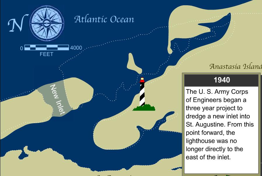

4 The Navigation Project and Erosional Hotspot 1862 Navigation Map 6 July
 4.")

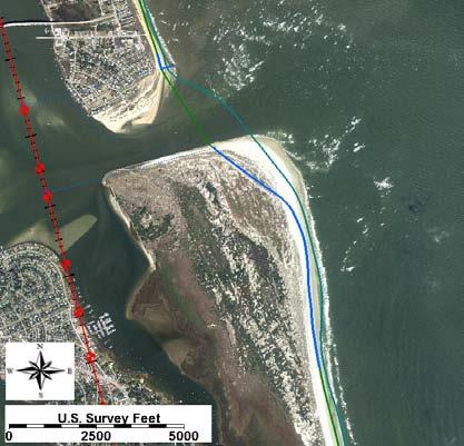
5 Planned and Historic District Activity in Last Decade St. Augustine Ebb-shoal Mining St. Augustine Beach Shore Protection Project Bathymetry Project 2003 Phase 1 Phase 2 Volume Placed (CY) 4.2 mcy Placeme nt Area R-145 to R-151 T-132 to R mcy R-137A 4.5 MCY Legault et al., 2012 to R-151 Placement Length 1.1 miles 3.6 miles 2.6 miles Project Vilano Beach Feasibility Study Volume Placed (CY) Placement Area Placement Length Difference Proposed Project 880 kcy R-109 to R miles 6 July
6 Problem Statement Investigate optimal dredging volumes and intervals, and determine the beach placement volume and interval that will adequately supply sand to maintain two Shore Protection Projects in St. Johns County. Questions: What is the volumetric limit (cubic yards of sediment) that can be mined regularly from the ebb shoal in its present condition which does not cause a significant long-term effect on the morphology and volumetric recovery of the shoal? How much sediment and what nourishment interval is required to maintain present volume of the active and planned Shore Protection Projects? 6 July


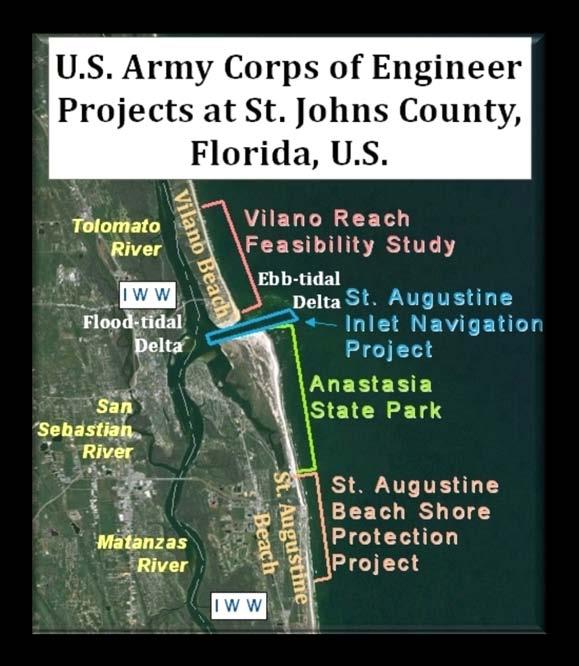
7 The Coastal Modeling System (CMS) at St. Augustine Inlet Analysis to Conduct: Volumetric change of ebb shoal Planform change of ebb shoal Shoreline position Beck and Legault, July


8 Comparison to the 1.5 MCY Removed A Planform Extent B A Volumetric Change B Sediment Transport Pathways Beck and Legault, July

9 Ebb Delta Mining Alternatives 6 July

10 Ebb Shoal Collapse in the 4.0 MCY Removed Scenario Certain conditions collapse the active shoal through disruption of natural sand pathways by reducing its depth either through deflation or collapse and/or reducing its planform area Functionality of the updrift channel margin shoal is crucial needed to sustain channelized flow to maintain typical bypassing 6 July
 determined from 2001-03 and 2005 mining events 4 MCY Cutoff dv/dt (kcy/yr) 350 330 310 290 270 250 230 210 190 170 150 Time Rate of Change of Ebb Shoal")
11 Dredging Boundaries: CMS Results & Historical Data Ebb Shoal Recovery: CMS Cannot remove so much as to force the inlet out of equilibrium : <4MCY Account for inlet recovery by historical evidence for infilling: Rate of volume change (growth) determined from and 2005 mining events 4 MCY Cutoff dv/dt (kcy/yr) Time Rate of Change of Ebb Shoal Volume YEAR dv/dt (kcy/yr) Time Rate of Change of Ebb Shoal Volume dv/dt = 60000ln(x) R² = time (years) POST-PROJECT PRE-PROJECT d 2 V/dt 2 =60000/t Beck and Legault, 2012 Legault et al., July
12 Defining Dredging Interval Alternatives for 50-YR Planning Horizon Legault et al., 2012 Dredging intensity scenarios considering equal or accretional status of the ebbtidal delta. Scenario Dredged Volume Dredging Interval Beach Placement Volume Beach Placement Location & Length Alt A1 1.0 MCY 5 Years 1.0 MCY Alt A MCY 5 Years 1.35 MCY Alt A3 2.0 MCY 7 Years 2.0 MCY Alt A4 3.0 MCY 10 Years 3.0 MCY T137a R151 (15,000 lft) T137a R151 (15,000 lft) T137a R151 (15,000 lft) T137a R151 (15,000 lft) 6 July

 80 cy/lft T137a R151 (15,000 lft) Alt C1 3.0 MCY 10 Years 3.")
13 Refined Nourishment Intervals for 50-YR Planning Horizon Optimized beach fill placement scenarios following the results of the Alternative A dredging scenarios. Beach Placement Location & Scenario Dredged Volume Dredging Interval Beach Placement Volume Length Alt B MCY 5 Years 1.35 MCY 70 cy/lft T132 R151 (20,000 lft) Alt B MCY (Includes Vilano Shoal ~300KCY) 5 Years 1.65 MCY 40 cy/lft R109 R120 (11,000 lft) 80 cy/lft T137a R151 (15,000 lft) Alt C1 3.0 MCY 10 Years 3.0 MCY 50 cy/lft R109 R120 (11,000 lft) 125 cy/lft T132 R151 (20,000 lft) Alt C2 3.0 MCY 10 Years 3.0 MCY 100 cy/lft 125 cy/lft R109 R120 (11,000 lft) T137a R151 (15,000 lft) 6 July


14 The GenCade Model GenCade is a one-dimensional (1-D) numerical model that calculates regional coastal change including inlet voumetric evolution. The model is a combination of Genesis, a shoreline change model designed for project-scale engineering studies, and Cascade, a regional alongshore sediment transport model that includes barrier islands and the inlets that separate them. <- IRM <- IRM The combination of the two models, with the addition of the Inlet Reservoir Model, which investigates the sediment sinks in inlets, result in a regional model capable of modeling shoreline change at the structure or project level, up to regional distances on the order of hundreds of kilometers. 6 July

15 GenCade Reaches of St. Johns Co., FL (R-Monument Profile Locations) Location Reach (R-Mon) Ponte Vedra Beach S. Ponte Vedra & Vilano Beach St. Augustine Inlet Anastasia Island Headland St. Augustine Beach Crescent Beach to Matanzas Inlet R1 R109 R109 R122 Ebb & Flood Tidal Deltas R123 R128 R128 R151 R151 R195 6 July
16 RESULTS: Ebb-Tidal Delta Volume Change for Alternatives 6 July


17 RESULTS: Plotted Shoreline Position on GenCade Grid 40 cy/lft 5 yr 50 cy/lft 10 yr 100 cy/lft 10 yr 70 cy/lft 5 yr 80 cy/lft 5 yr 125 cy/lft 10 yr 125 cy/lft 10 yr 6 July

18 Volumetric Results of Alternatives 67 cy/lft 5 yr 90 cy/lft 5 yr 133 cy/lft 7 yr 200 cy/lft 10 yr 67 cy/lft 5 yr 40 cy/lft 80 cy/lft 5 yr 50 cy/lft 125 cy/lft 10 yr 100 cy/lft 125 cy/lft 10 yr 6 July
19 Summary An analysis of the CMS model results determined that dredging scenarios under 4 MCY removed did not significantly modify the ebb-tidal delta through the 1) elevation and planform extent, 2) sediment transport patterns, or 3) volume flux provided to the adjacent beaches. The CMS modeling results provided crucial constructive bounds on the optimized scenarios modeled in GenCade. The benefits of coordinating and modifying dredging volumes and intervals can be explored in GenCade simultaneously with varying beach fill volumes and intervals to calculate how sediment sources and sinks evolve over time for future sediment budgets. An analysis of the GenCade results found that there is not a sustainable dredging amount and interval for St. Augustine Inlet that will meet the beach fill needs of St. Johns County. At least another 1 MCY/YR is necessary to sustain the present SPP. The greatest benefit of this methodology is in determining optimal dredging periods and coordinating regional efforts to save in mobilization and demobilization costs for dredging and beach fill placement. 6 July
20 Thank You! Questions? Three Part Technical Report Series Published by ERDC/CHL: Legault K.R. Rosati J.D., Beck T.M., and Engle J St. Johns County, St. Augustine Inlet, FL Report 1: Historical Analysis and Sediment Budget. Technical Report ERDC-TR-12-XX, U.S. Army Research and Development Center, Vicksburg, MS. Beck, T.M. and Legault K.R St. Augustine Inlet, Florida: Application of the Coastal Modeling System, Report 2. Technical Report ERDC-TR-12-XX, U.S. Army Research and Development Center, Vicksburg, MS. Beck, T.M. and Legault K.R Optimization of Ebb Shoal Mining and Beach Nourishment at St. Johns County, St. Augustine Inlet, FL, Report 3. Technical Report ERDC-TR-12-XX, U.S. Army Research and Development Center, Vicksburg, MS. 6 July
Passage Key Inlet, Florida; CMS Modeling and Borrow Site Impact Analysis
 Passage Key Inlet, Florida; CMS Modeling and Borrow Site Impact Analysis by Kelly R. Legault and Sirisha Rayaprolu PURPOSE: This Coastal and Hydraulics Engineering Technical Note (CHETN) describes the
Coastal and Hydraulics Laboratory
 ERDC/CHL TR-12-14 Coastal Inlets Research Program St. Johns County, St. Augustine Inlet, FL Report 1: Historical Analysis and Sediment Budget Kelly Legault, Julie D. Rosati, Jason Engle, and Tanya M. Beck
GenCade Applications Ashley Frey
 GenCade Applications Ashley Frey Research Civil Engineer, Co-PI of the Inlet Engineering Toolbox work unit of CIRP Report Documentation Page Form Approved OMB No. 0704-0188 Public reporting burden for
Coastal and Hydraulics Laboratory
 ERDC/CHL TR-12-14 Coastal Inlets Research Program St. Augustine Inlet, Florida: Application of the Coastal Modeling System Report 2 Tanya M. Beck and Kelly Legault August 2012 Coastal and Hydraulics Laboratory
Inlet Management Study for Pass-A-Grille and Bunces Pass, Pinellas County, Florida
 Inlet Management Study for Pass-A-Grille and Bunces Pass, Pinellas County, Florida Final Report Submitted By Ping Wang, Ph.D., Jun Cheng Ph.D., Zachary Westfall, and Mathieu Vallee Coastal Research Laboratory
EVALUATION OF BEACH EROSION UP-DRIFT OF TIDAL INLETS IN SOUTHWEST AND CENTRAL FLORIDA, USA. Mohamed A. Dabees 1 and Brett D.
 EVALUATION OF BEACH EROSION UP-DRIFT OF TIDAL INLETS IN SOUTHWEST AND CENTRAL FLORIDA, USA Mohamed A. Dabees 1 and Brett D. Moore 1 The paper discusses the analysis of up-drift beach erosion near selected
Evaluation of Placement Alternatives for Matagorda Ship Channel Bottleneck Removal
 Evaluation of Placement Alternatives for Matagorda Ship Channel Bottleneck Removal James Rosati III Ashley E. Frey CPT Grays Harbor, WA Wood Wood chips Flour Other CMS Shark River Inlet, NJ US Army Corps
GENERAL METHODOLOGY FOR INLET RESERVOIR MODEL ANALYSIS OF SAND MANAGEMENT NEAR TIDAL INLETS. Mohamed A. Dabees 1, Nicholas C.
 GENERAL METHODOLOGY FOR INLET RESERVOIR MODEL ANALYSIS OF SAND MANAGEMENT NEAR TIDAL INLETS Mohamed A. Dabees 1, Nicholas C. Kraus 2 1 Humiston& Moore Engineers, 5679 Strand Court, Naples, FL 34109, USA.
Nearshore Placed Mound Physical Model Experiment
 Nearshore Placed Mound Physical Model Experiment PURPOSE: This technical note describes the migration and dispersion of a nearshore mound subjected to waves in a physical model. The summary includes recommendations
NUMERICAL SIMULATION OF SEDIMENT PATHWAYS AT AN IDEALIZED INLET AND EBB SHOAL
 In: Proceedings Coastal Sediments 03. 2003. CD-ROM Published by World Scientific Publishing Corp. and East Meets West Productions, Corpus Christi, Texas, USA. ISBN 981-238-422-7. NUMERICAL SIMULATION OF
CHAPTER 281 INFLUENCE OF NEARSHORE HARDBOTTOM ON REGIONAL SEDIMENT TRANSPORT
 CHAPTER 281 INFLUENCE OF NEARSHORE HARDBOTTOM ON REGIONAL SEDIMENT TRANSPORT Paul C.-P. Lin, Ph.D., P.E. 1 and R. Harvey Sasso, P.E. 2 ABSTRACT The influence of nearshore hardbottom on longshore and cross-shore
Assateague Island National Seashore North End Restoration Project Timeline
 Assateague Island National Seashore North End Restoration Project Timeline Date Event Some information provided in the Project Introduction document. Detailed events are available in a timeline compiled
US Beach Nourishment Experience:
 Beach Nourishment: Introduction of new sand to the beach by truck or dredge Large beach >1 million cubic yards (100,000 dump truck loads) Funding is a combination of federal, state, local & private Also
Modeling Sediment Transport Along the Upper Texas Coast
 Modeling Sediment Transport Along the Upper Texas Coast David B. King Jr. Jeffery P. Waters William R. Curtis Highway 87 roadbed, Jefferson County Galveston District Corps Sabine Pass to San Luis Pass
GenCade Application at Onslow Bay, North Carolina
 GenCade Application at Onslow Bay, North Carolina by Ashley E. Frey, Sophie Munger, Greg L. Williams, Michael J. Wutkowski, and Kevin B. Conner PURPOSE: This Coastal and Hydraulics Engineering Technical
Kelly Legault, Ph.D., P.E. USACE SAJ
 Kelly Legault, Ph.D., P.E. USACE SAJ Report Documentation Page Form Approved OMB No. 0704-0188 Public reporting burden for the collection of information is estimated to average 1 hour per response, including
Appendix E Cat Island Borrow Area Analysis
 Appendix E Cat Island Borrow Area Analysis ERDC/CHL Letter Report 1 Cat Island Borrow Area Analysis Multiple borrow area configurations were considered for Cat Island restoration. Borrow area CI1 is located
A Modeling Study of Coastal Sediment Transport and Morphology Change
 A Modeling Study of Coastal Sediment Transport and Morphology Change Honghai Li 1, Alejandro Sanchez 1, Mitchell E. Brown 1, Irene M. Watts 2, Zeki Demirbilek 1, Julie D. Rosati 1, and David R. Michalsen
Coastal and Hydraulics Laboratory
 ERDC/CHL TR-17-13 Regional Sediment Management (RSM) Program Sediment Budget Analysis; Masonboro Inlet, North Carolina Kevin B. Conner and Linda S. Lillycrop August 2017 Coastal and Hydraulics Laboratory
SACO RIVER AND CAMP ELLIS BEACH SACO, MAINE SECTION 111 SHORE DAMAGE MITIGATION PROJECT APPENDIX F ECONOMIC ASSESSMENT
 SACO RIVER AND CAMP ELLIS BEACH SACO, MAINE SECTION 111 SHORE DAMAGE MITIGATION PROJECT APPENDIX F ECONOMIC ASSESSMENT Department of the Army New England District, Corps of Engineers 696 Virginia Road
Coastal and Hydraulics Laboratory
 ERDC/CHL TR-11-2 Coastal Inlets Research Program Analysis of Dredged Material Placement Alternatives for Bottleneck Removal, Matagorda Ship Channel, Texas James Rosati III, Ashley E. Frey, Mitchell E.
PLAQUEMINES PARISH BARRIER ISLAND RESTORATION & SUSTAINABILITY. MVD/Gulf Coast Regional Dredging Meeting November 5, 2013
 PLAQUEMINES PARISH BARRIER ISLAND RESTORATION & SUSTAINABILITY MVD/Gulf Coast Regional Dredging Meeting November 5, 2013 OVERVIEW 1. Barrier Island Restoration Projects in Plaquemines Parish 2. Plaquemines
MOREHEAD CITY HARBOR, NC. Dredged Material Management Plan (DMMP)
") MOREHEAD CITY HARBOR, NC Dredged Material Management Plan (DMMP) Public Meeting/Info Session 15 January 2014 US Army Corps of Engineers Morehead City Harbor DMMP Presentation Topics Morehead City Harbor
MOREHEAD CITY HARBOR, NC Dredged Material Management Plan (DMMP) Public Meeting/Info Session 15 January 2014 US Army Corps of Engineers Morehead City Harbor DMMP Presentation Topics Morehead City Harbor
Shoreline Change Modeling Using One-Line Models: Application and Comparison of GenCade, Unibest, and Litpack
 Shoreline Change Modeling Using One-Line Models: Application and Comparison of GenCade, Unibest, and Litpack by Kimberly E. Townsend, Robert C. Thomas, and Ashley E. Frey PURPOSE: The purpose of this Coastal
FINAL ENVIRONMENTAL IMPACT STATEMENT ON BROWARD COUNTY SHORE PROTECTION PROJECT SEGMENTS II AND III BROWARD COUNTY, FLORIDA
 FINAL ENVIRONMENTAL IMPACT STATEMENT ON BROWARD COUNTY SHORE PROTECTION PROJECT SEGMENTS II AND III BROWARD COUNTY, FLORIDA 1. PROJECT PURPOSE AND NEED 1.1. PROJECT AUTHORITY. 1.1.1. INITIAL AUTHORIZATION.
Shoreline Change in Response to Sea Level Rise on Florida s Panhandle Coast. Jim Houston `
 Shoreline Change in Response to Sea Level Rise on Florida s Panhandle Coast Jim Houston james.r.houston @usace.army.mil ` Approach Calculate historical shoreline change by county (1867-2015) Determine
Techniques for Measuring and Analyzing Inlet Ebb-Shoal Evolution
 US Army Corps of Engineers Coastal Engineering Technical Note IV-13 Techniques for Measuring and Analyzing Inlet Ebb-Shoal Evolution by Donald K. Stauble PURPOSE: The Coastal Engineering Technical Note
Follets Island Nearshore Beach Nourishment Project
 Coast & Harbor Engineering A division of Hatch Mott MacDonald Follets Island Nearshore Beach Nourishment Project Arpit Agarwal, P.E. April 1, 2016 Project Site!"#$% &'(% &)*+% )#,'-+% Shoreline Erosion
Coastal Sediment Transport Modeling Ocean Beach & San Francisco Bight, CA
 1 Coastal Sediment Transport Modeling Ocean Beach & San Francisco Bight, CA Honghai Li and Lihwa Lin Engineering Research and Development Center U.S. Army Corps of Engineers Frank Wu, Lisa Andes, and James
Long Term Success and Future Approach of the Captiva and Sanibel Islands Beach Renourishment Program
 2017 National Conference on Beach Preservation Technology February 8-10, 2017; Stuart, Florida Long Term Success and Future Approach of the Captiva and Sanibel Islands Beach Renourishment Program Thomas
Reservoir Model for Calculating Natural Sand Bypassing and Change in Volume of Ebb-Tidal Shoals, Part I: Description
 Reservoir Model for Calculating Natural Sand Bypassing and Change in olume of Ebb-Tidal Shoals, Part I: Description by Nicholas C. Kraus PURPOSE: The Coastal and Hydraulics Engineering Technical Note (CHETN)
ST. JOSEPH PENINSULA, GULF COUNTY, FLORIDA Beach Re-Nourishment and Environmental Enhancement Project RECOMMENDATIONS
 ST. JOSEPH PENINSULA, GULF COUNTY, FLORIDA Beach Re-Nourishment and Environmental Enhancement Project RECOMMENDATIONS January 23, 2018 543 Harbor Boulevard, Suite 204 Destin, Florida 32541 850.654.1555
UPPER BEACH REPLENISHMENT PROJECT RELATED
 ASSESSMENT OF SAND VOLUME LOSS at the TOWNSHIP of UPPER BEACH REPLENISHMENT PROJECT RELATED to the LANDFALL OF HURRICANE SANDY - PURSUANT TO NJ-DR 4086 This assessment is in response to Hurricane Sandy
STORM RESPONSE SIMULATION
 APPENDIX V STORM RESPONSE SIMULATION Final Environmental Impact Statement Village of Bald Head Island Shoreline Protection Project Brunswick County, North Carolina Delft3D Storm Response Simulations With
Town of Duck, North Carolina
 Tracking No. 00.00.2010 Erosion Mitigation And Shoreline Management Feasibility Study Town of Duck, North Carolina Coastal Planning & Engineering of North Carolina August 15, 2012 Tom Jarrett Robert Neal
Coastal and Hydraulics Laboratory
 ERDC/CHL TR-10-4 Coastal Inlets Research Program Shark River Inlet, New Jersey, Entrance Shoaling: Report 2, Analysis with Coastal Modeling System Tanya M. Beck and Nicholas C. Kraus July 2010 Coastal
Nearshore Dredged Material Placement Pilot Study at Noyo Harbor, CA
 1 Nearshore Dredged Material Placement Pilot Study at Noyo Harbor, CA Noyo Cove N 2011 National Conference on Beach Preservation Technology 9-11, February 2011 Lihwa Lin, Honghai Li, Mitchell Brown US
Q1. What are the primary causes/contributors to coastal erosion at Westshore and the concept of longshore / littoral drift.
 Q1. What are the primary causes/contributors to coastal erosion at Westshore and the concept of longshore / littoral drift. In order of (timing related) contribution to present problem 1. Beach is too
MIAMI BEACH 32ND STREET HOT SPOT: NUMERICAL MODELING AND DESIGN OPTIMIZATION. Adam Shah - Coastal Engineer Harvey Sasso P.E.
 ABSTRACT MIAMI BEACH 32ND STREET HOT SPOT: NUMERICAL MODELING AND DESIGN OPTIMIZATION Adam Shah - Coastal Engineer Harvey Sasso P.E. - Principal Coastal Systems International, Inc. 464 South Dixie Highway
ST. LUCIE COUNTY, FLORIDA
 ST. LUCIE COUNTY, FLORIDA COASTAL STORM RISK MANAGEMENT STUDY Draft Feasibility Study & Integrated Environmental Assessment Public Meeting Presented by U.S. Army Corps of Engineers Jacksonville District
Regular Workshop October 20, 2014 Agenda Item: Dr. Albert E. Browder, PE; Olsen Associates, Inc.
 Regular Workshop October 20, 2014 Agenda Item 8 Agenda Item: Presenter: Summary: Beach Update Town Manager; Dr. Albert E. Browder, PE; Olsen Associates, Inc. At the January 21, 2014 Regular Workshop Meeting,
Physical Modeling of Nearshore Placed Dredged Material Rusty Permenter, Ernie Smith, Michael C. Mohr, Shanon Chader
 Physical Modeling of Nearshore Placed Dredged Material Rusty Permenter, Ernie Smith, Michael C. Mohr, Shanon Chader Research Hydraulic Engineer ERDC-Coastal Hydraulics Laboratory October 25,2012 Study
Impact of Hurricane Matthew on the Atlantic Coast of Florida
 Impact of Hurricane Matthew on the Atlantic Coast of Florida A coastal engineer was driving across country and his jeep broke down in front of a monastery. It was late in the day and the monks invited
Effect of Hydrodynamics on Sediment Transport near a Coastal Inlet
 ICHE 2014, Hamburg - Lehfeldt & Kopmann (eds) - 2014 Bundesanstalt für Wasserbau ISBN 978-3-939230-32-8 Effect of Hydrodynamics on Sediment Transport near a Coastal Inlet H. Li, M. Brown, J. Rosati & Z.
Volume and Shoreline Changes along Pinellas County Beaches during Tropical Storm Debby
 Volume and Shoreline Changes along Pinellas County Beaches during Tropical Storm Debby Ping Wang and Tiffany M. Roberts Coastal Research Laboratory University of South Florida July 24, 2012 Introduction
Beach Nourishment Impact on Beach Safety and Surfing in the North Reach of Brevard County, Florida
 Beach Nourishment Impact on Beach Safety and Surfing in the North Reach of Brevard County, Florida Prepared by John Hearin, Ph.D. Coastal Engineering Vice Chairman Cocoa Beach Chapter Port Canaveral Patrick
Salt Ponds Shore Zone Modeling for Breakwater Placement: Summary Report
 Salt Ponds Shore Zone Modeling for Breakwater Placement: Summary Report Virginia Institute of Marine Science May 2014 Salt Ponds Shore Zone Modeling for Breakwater Placement: Summary Report For Waterway
CLAM PASS RESTORATION AND MANAGEMENT PLAN BATHYMETRIC MONITORING REPORT NO. 7 Including Interior Bay Dredge Cuts and Tidal Data
 CLAM PASS RESTORATION AND MANAGEMENT PLAN BATHYMETRIC MONITORING REPORT NO. 7 Including Interior Bay Dredge Cuts and Tidal Data Submitted to: Florida Department of Environmental Protection DEP File No.
Evaluation of Ebb-Tidal Shoals as a Sand Source for Beach Nourishment: General Methodology with Reservoir Model Analysis
 Evaluation of Ebb-Tidal hoals as a and ource for each Nourishment: General Methodology with Reservoir Model Analysis Mohamed A. Dabees 1 and Nicholas C. Kraus 2 1 Humiston& Moore Engineers, 5679 trand
APPENDIX A Hydrodynamic Model Qualicum Beach Waterfront Master Plan
 Page 1 of 21 CLIENT: Town of Qualicum Beach PROJECT: SIGNATURE DATE CONTRIBUTORS : M. Marti Lopez REVIEWED BY : P. St-Germain, EIT APPROVED BY: J. Readshaw, P.Eng ISSUE/REVISION INDEX Issue Details Code
Sediment Transport Analysis Village of Asharoken, New York
 Sediment Transport Analysis Village of Asharoken, New York NORTH SHORE OF LONG ISLAND, NEW YORK COMBINED EROSION CONTROL AND STORM DAMAGE PROTECTION FEASIBILITY STUDY FINAL REPORT August 2004 Cell 0 Asharoken
3.3 OCEANOGRAPHY/COASTAL PROCESSES
 3.3 OCEANOGRAPHY/COASTAL PROCESSES Beaches are dynamic and conditions vary based on the onshore/offshore movement of sand both seasonally and annually. Sand also moves alongshore within a generally defined
Coastal Modeling System: Dredging Module
 Coastal Modeling System: Dredging Module by Chris Reed and Alejandro Sánchez PURPOSE: This Coastal and Hydraulics Engineering Technical Note (CHETN) describes the implementation of a dredging module (DM)
Inlet Impacts on Local Coastal Processes
 Inlet Impacts on Local Coastal Processes Rajesh Srinivas 1, Associate Member, and R. Bruce Taylor 1, Fellow Abstract St. Augustine Inlet, a trained, ebb-dominated inlet, acts as an efficient sediment trap
LITTLE LAGOON & LITTLE LAGOON PASS: RESEARCH UPDATES & DIRECTIONS
 LITTLE LAGOON & LITTLE LAGOON PASS: RESEARCH UPDATES & DIRECTIONS Bret M. Webb, PhD, PE, DCE Professor Department of Civil, Coastal, and Environmental Engineering October 19, 2017 LLPS Meeting Acknowledgments
EDISTO BEACH COASTAL STORM DAMAGE REDUCTION GENERAL INVESTIGATION STUDY APPENDIX E BORROW AREA IMPACT ANALYSIS
 EDISTO BEACH COASTAL STORM DAMAGE REDUCTION GENERAL INVESTIGATION STUDY APPENDIX E BORROW AREA IMPACT ANALYSIS BORROW AREA IMPACT ANALYSIS FOR EDISTO BEACH, SC Introduction Edisto Island is located on
KEYNOTE PRESENTATION FSBPA olsen
 AMELIA ISAND, FLORIDA BEACH MANAGEMENT PARTNERING AND PERSERVERENCE Erik Olsen, PE associates, inc. KEYNOTE PRESENTATION FSBPA 2009 IN ORDER TO ADDRESS SHORE PROTECTION TODAY LOCAL INTERESTS PARTNER WITH:
This article appeared in a journal published by Elsevier. The attached copy is furnished to the author for internal non-commercial research and
 This article appeared in a journal published by Elsevier. The attached copy is furnished to the author for internal non-commercial research and education use, including for instruction at the authors institution
Figure 1 Example feature overview.
 1. Introduction This case focuses on the northeastern region of Onslow Bay, NC, and includes an initial shoreline, regional contour, wave gauges, inlets, dredging, and beach fills. Most of the features
INFLUENCES OF CHANNEL DREDGING ON FLOW AND SEDIMENTATION PATTERNS AT MICROTIDAL INLETS, WEST-CENTRAL FLORIDA, USA. Tanya M. Beck 1 and Ping Wang 2
 INFLUENCES OF CHANNEL DREDGING ON FLOW AND SEDIMENTATION PATTERNS AT MICROTIDAL INLETS, WEST-CENTRAL FLORIDA, USA Tanya M. Beck 1 and Ping Wang 2 Abstract Four inlets (Johns Pass and Blind Pass; and New
The influence of dredging activities on the morphological development of the Columbia River mouth MSc Thesis
 The influence of dredging activities on the morphological development of the Columbia River MSc Thesis Jeroen Stark Deltares, 2012 Title Pages 145 Keywords Long-term morphodynamics, Columbia River, ebb-tidal
CROSS-SHORE SEDIMENT PROCESSES
 The University of the West Indies Organization of American States PROFESSIONAL DEVELOPMENT PROGRAMME: COASTAL INFRASTRUCTURE DESIGN, CONSTRUCTION AND MAINTENANCE A COURSE IN COASTAL DEFENSE SYSTEMS I CHAPTER
COASTAL EVOLUTION MODELING AT MULTIPLE SCALES IN REGIONAL SEDIMENT MANAGEMENT APPLICATIONS
 1920 COASTAL EVOLUTION MODELING AT MULTIPLE SCALES IN REGIONAL SEDIMENT MANAGEMENT APPLICATIONS HANS HANSON 1, KENNETH J. CONNELL 2, MAGNUS LARSON 1, NICHOLAS C. KRAUS 3, TANYA M. BECK 3, ASHLEY E. FREY
FINDING OF NO SIGNIFICANT IMPACT
 DEPARTMENT OF THE ARMY CHARLESTON DISTRICT, CORPS OF ENGINEERS 69A HAGOOD AVENUE CHARLESTON, SOUTH CAROLINA 29403-5107 FINDING OF NO SIGNIFICANT IMPACT EDISTO BEACH COASTAL STORM DAMAGE REDUCTION GENERAL
CLAM PASS ANNUAL RESTORATION & MANAGEMENT PLAN TIDAL ANALYSIS ELEMENT REPORT NO. 13
 CLAM PASS ANNUAL RESTORATION & MANAGEMENT PLAN TIDAL ANALYSIS ELEMENT REPORT NO. 13 Submitted to: Pelican Bay Services Division Prepared by: Humiston & Moore Engineers H&M File No. 13-078 November 2012
Town of Duck, North Carolina
 Tracking No. 00.00.2010 Erosion Mitigation And Shoreline Management Feasibility Study Town of Duck, North Carolina Coastal Planning & Engineering of North Carolina February 28, 2013 Ken Willson 1 Tracking
100-YEARS OF SHOAL EVOLUTION AT THE MOUTH OF THE COLUMBIA RIVER: IMPACTS ON CHANNEL, STRUCTURES, AND SHORELINES
 100-YEARS OF SHOAL EVOLUTION AT THE MOUTH OF THE COLUMBIA RIVER: IMPACTS ON CHANNEL, STRUCTURES, AND SHORELINES Hans R. Moritz, 1 Heidi P. Moritz, 2 Jessica R. Hays, 3 and Heather R. Sumerell 4 Abstract:
CMS Modeling of the North Coast of Puerto Rico
 CMS Modeling of the North Coast of Puerto Rico PRESENTED BY: Dr. Kelly Rankin Legault, Ph.D., P.E. 1 Dr. Alfredo Torruella, Ph.D. 2 1 USACE Jacksonville District 2 University of Puerto Rico October 2016
First Year Morphological Evolution of an Artificial Berm at Fort Myers Beach, Florida
 University of South Florida Scholar Commons Geology Faculty Publications Geology 1-2012 First Year Morphological Evolution of an Artificial Berm at Fort Myers Beach, Florida Katherine Brutsche University
AN OVERVIEW OF RECENT PROJECTS RELATED TO SAND BUDGETS, SOUTHERN CALIFORNIA BEACHES
 AN OVERVIEW OF RECENT PROJECTS RELATED TO SAND BUDGETS, SAND SUPPLY, COASTAL ARMORING, MANAGEMENT, AND VALUING SOUTHERN CALIFORNIA BEACHES Dr. Kiki Patsch California State University Channel Islands Environmental
Oceans and Coasts. Chapter 18
 Oceans and Coasts Chapter 18 Exploring the oceans The ocean floor Sediments thicken and the age of the seafloor increases from ridge to shore The continental shelf off the northeast United States Constituent
OECS Regional Engineering Workshop September 29 October 3, 2014
 B E A C H E S. M A R I N A S. D E S I G N. C O N S T R U C T I O N. OECS Regional Engineering Workshop September 29 October 3, 2014 Coastal Erosion and Sea Defense: Introduction to Coastal/Marine Structures
New Jersey Coastal Zone Overview. The New Jersey Beach Profile Network (NJBPN) 3 Dimensional Assessments. Quantifying Shoreline Migration
 3 Dimensional Assessments. Quantifying Shoreline Migration") New Jersey Coastal Zone Overview The New Jersey Beach Profile Network (NJBPN) Objectives Profile Locations Data Collection Analyzing NJBPN Data Examples 3 Dimensional Assessments Methodology Examples Quantifying
New Jersey Coastal Zone Overview The New Jersey Beach Profile Network (NJBPN) Objectives Profile Locations Data Collection Analyzing NJBPN Data Examples 3 Dimensional Assessments Methodology Examples Quantifying
Comparison of Predicted and Measured Shoaling at Morro Bay Harbor Entrance, California
 Comparison of Predicted and Measured Shoaling at Morro Bay Harbor Entrance, California by Edward F. Thompson, Inocencio P. DiRamos, and Robert R. Bottin, Jr. PURPOSE: This Coastal and Hydraulics Engineering
Barrier Progradation Related to Inlet Spacing and Migration Patterns L.E. Budde and W.J. Cleary
 Journal of Coastal Research SI 39 117-121 ICS 2004 (Proceedings) Brazil ISSN 0749-0208 Barrier Progradation Related to Inlet Spacing and Migration Patterns L.E. Budde and W.J. Cleary MS Candidate, Center
CHAPTER 86 PERFORMANCE OF A JETTY-WEIR INLET IMPROVEMENT PLAN. J. A. Purpura 1, B. C. Beechley 2. C. W. Baskette, Jr. 3, J. C. Roberge 1 * ABSTRACT
 CHAPTER 86 PERFORMANCE OF A JETTY-WEIR INLET IMPROVEMENT PLAN by J. A. Purpura 1, B. C. Beechley 2 C. W. Baskette, Jr. 3, J. C. Roberge 1 * ABSTRACT Comprehensive monitoring has been carried out since
ABSTRACT. KEY WORDS: Navigation safety; numerical modeling; waves; current; sediment transport; channel infilling; morphology change.
 The 25th (2015) International Polar and Engineering Conference Li, H., L. Lin, Z. Demirbilek, T. M. Beck, and H. R. Moritz (2015). Wave-Current Conditions and Navigation Safety at an Inlet Entrance. The
TRANSPORT OF NEARSHORE DREDGE MATERIAL BERMS
 Proceedings of the 6 th International Conference on the Application of Physical Modelling in Coastal and Port Engineering and Science (Coastlab16) Ottawa, Canada, May 10-13, 2016 Copyright : Creative Commons
Analysis of Packery Channel Public Access Boat Ramp Shoreline Failure
 Journal of Coastal Research SI 59 150-155 West Palm Beach, Florida 2011 Analysis of Packery Channel Public Access Boat Ramp Shoreline Failure Christopher W. Reed and Lihwa Lin URS Corporation 1625 Summit
NAVIGATION STUDY FOR LAKE WORTH INLET, FLORIDA DRAFT INTEGRATED FEASIBILITY REPORT AND ENVIRONMENTAL IMPACT STATEMENT APPENDIX A ENGINEERING
 NAVIGATION STUDY FOR LAKE WORTH INLET, FLORIDA DRAFT INTEGRATED FEASIBILITY REPORT AND ENVIRONMENTAL IMPACT STATEMENT APPENDIX A ENGINEERING NAVIGATION STUDY FOR LAKE WORTH INLET, FLORIDA DRAFT INTEGRATED
Comparisons of Physical and Numerical Model Wave Predictions with Prototype Data at Morro Bay Harbor Entrance, California
 Comparisons of Physical and Numerical Model Wave Predictions with Prototype Data at Morro Bay Harbor Entrance, California by Robert R. Bottin, Jr. and Edward F. Thompson PURPOSE: This Coastal and Hydraulics
APPENDIX C. Fluvial and Tidal Hydraulics Report
 APPENDIX C Fluvial and Tidal Hydraulics Report BUENA VISTA LAGOON ENHANCEMENT PROJECT FLUVIAL AND TIDAL HYDRAULICS ANALYSES Prepared for: SANDAG 401 B Street, Suite 800 San Diego, California 92101 Contact:
Beach Restoration in Okaloosa and Walton Counties. FSBPA Technology Conference Clearwater, FL
 Beach Restoration in Okaloosa and Walton Counties FSBPA Technology Conference Clearwater, FL Presented by: Duncan Greer, E.I. February 5, 2015 PRESENTATION OUTLINE 1. Overview of Project Locations 2. Eglin
FEASIBILITY OF SAND BYPASSING SYSTEMS
 MISCELLANEOUS PAPER HL-88-9 FEASIBILITY OF SAND BYPASSING SYSTEMS Of " EngFOR REDUCING MAINTENANCE DREDGING IN THE ST. MARYS RIVER ENTRANCE CHANNEL by David R. Richards ji NHydraulics tand Laboratory James
APPENDIX D W-19 FLUVIAL AND TIDAL HYDRAULIC, SEDIMENTATION, WATER QUALITY AND SEA LEVEL RISE MODELING STUDIES
 APPENDIX D W-19 FLUVIAL AND TIDAL HYDRAULIC, SEDIMENTATION, WATER QUALITY AND SEA LEVEL RISE MODELING STUDIES Final EIR November 2018 Appendices Executive Summary Background: The San Dieguito Lagoon W19
Recycling of Surplus Sand to Extend the Time Between Beach Fill Episodes
 Recycling of Surplus Sand to Extend the Time Between Beach Fill Episodes Cape May County, New Jersey Dr. Stewart Farrell Coastal Research Center 1795 Franklin Map Shows Inlets Inlet Morphology has Remained
RE: Hurricane Matthew Beach Damage Assessment and Recommendations [CSE 2416]
![RE: Hurricane Matthew Beach Damage Assessment and Recommendations [CSE 2416]](/thumbs/83/87675702.jpg "RE: Hurricane Matthew Beach Damage Assessment and Recommendations [CSE 2416]") October 25, 2016 Iris Hill Town Administrator Town of Edisto Beach 2414 Murray St Edisto Beach SC 29438 RE: Hurricane Matthew Beach Damage Assessment and Recommendations [CSE 2416] Dear Iris, Hurricane
October 25, 2016 Iris Hill Town Administrator Town of Edisto Beach 2414 Murray St Edisto Beach SC 29438 RE: Hurricane Matthew Beach Damage Assessment and Recommendations [CSE 2416] Dear Iris, Hurricane
Guidelines Based on Physical and Numerical Modeling Studies for Jetty Spur Design at Coastal Inlets
 International Journal of Ecology & Development Fall 2008; Vol. 11; No. F08; Int. J. Ecol. Dev.; 4-19 ISSN 0972-9984 ( Print ); ISSN 0973-7308 (Online) Copyright 2008 IJED, ISDER Guidelines Based on Physical
Southwest Washington Littoral Drift Restoration Project: Design, Construction, and Monitoring
 Southwest Washington Littoral Drift Restoration Project: Design, Construction, and Monitoring J Jessica i St Stokke kk USACE Portland District October 28, 2010 WEDA Pacific Meeting Monterey, CA US Army
City of Del Mar Local Coastal Plan (LCP) Amendment for Sea Level Rise and Coastal Flooding
 Amendment for Sea Level Rise and Coastal Flooding") City of Del Mar Local Coastal Plan (LCP) Amendment for Sea Level Rise and Coastal Flooding 6/22/17 Presentation to Sea Level Rise Stakeholder- Technical Advisory Committee (STAC) Nick Garrity, P.E. Lindsey
City of Del Mar Local Coastal Plan (LCP) Amendment for Sea Level Rise and Coastal Flooding 6/22/17 Presentation to Sea Level Rise Stakeholder- Technical Advisory Committee (STAC) Nick Garrity, P.E. Lindsey
INTRODUCTION TO COASTAL ENGINEERING
 The University of the West Indies Organization of American States PROFESSIONAL DEVELOPMENT PROGRAMME: COASTAL INFRASTRUCTURE DESIGN, CONSTRUCTION AND MAINTENANCE A COURSE IN COASTAL DEFENSE SYSTEMS I CHAPTER
Morphologic Asymmetries at Entrances to Tidal Inlets
 Morphologic Asymmetries at Entrances to Tidal Inlets by Erica Eva Carr and Nicholas C. Kraus PURPOSE: The Coastal and Hydraulics Engineering Technical Note (CHETN) herein discusses selected morphologic
CHAPTER 179. Performance of a Submerged Breakwater for Shore Protection
 CHAPTER 179 Abstract Performance of a Submerged Breakwater for Shore Protection Albert E. Browder',A. Member, ASCE; Robert G. Dean 2, Member, ASCE; and Renjie Chen 3 A summary is presented of the results
Effectiveness of Beach Nourishment in Response to Sea Level Rise
 2014 FSBPA Annual Conference Effectiveness of Beach Nourishment in Response to Sea Level Rise Navarre Beach Santa Rosa County July 18, 2005 Lovers Key Lee County April 23, 2012 South County St. Lucie County
Jetty Spur Functional Design at Coastal Inlets; Effects on Nearshore Circulation and Potential Sediment Movement
 Jetty Spur Functional Design at Coastal Inlets; Effects on Nearshore Circulation and Potential Sediment Movement by William C. Seabergh PURPOSE: This Coastal and Hydraulics Engineering Technical Note (CHETN)
Request Number IR1-12: Flow Passage. Information Request
 Request Number IR1-12: Flow Passage Information Request Provide additional information about the 100 metre flow passage channel scenario between the Westshore Terminals and the proposed Project terminal
Appendix G Applied Coastal Pipeline Impact Assessment
 Appendix G Applied Coastal Pipeline Impact Assessment Simulating the Potential Impact of Borrow Site Excavation on Sediment Transport Along the Gulfstream Pipeline, Petit Bois Pass, Alabama Prepared for:
EROSION CRITERION APPLIED TO A SHORELINE ADJACENT TO A COASTAL INLET
 EROSION CRITERION APPLIED TO A SHORELINE ADJACENT TO A COASTAL INLET By Brian Batten and Henry Bokuniewicz Marine Sciences Research Center State University of New York Stony Brook, New York 11794-5000
NC TERMINAL GROIN STUDY FINAL REPORT
 II. Physical Assessment This section addresses the geological framework, physical processes, and human-induced changes that influence erosional-depositional sedimentation patterns at tidal inlets and along
NOTICE and AGENDA. 1. Meeting Called to Order 2. Roll Call
 NOTICE and AGENDA CITY OF TREASURE ISLAND, FLORIDA BEACH STEWARSHIP COMMITTEE CITY HALL AUDITORIUM, 120 108th AVENUE, TREASURE ISLAND, FLORIDA 33706 WEDNESDAY, April 12, 2017 AT 1:30 PM Welcome to the