GLOBAL CORAL REEF ALLIANCE A non-profit organization for protection and sustainable management of coral reefs
|
|
|
- Charleen Waters
- 6 years ago
- Views:
Transcription
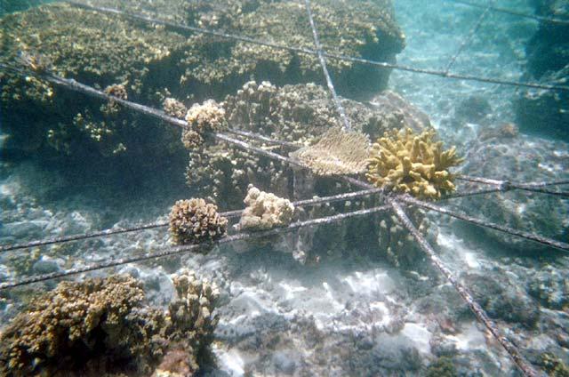
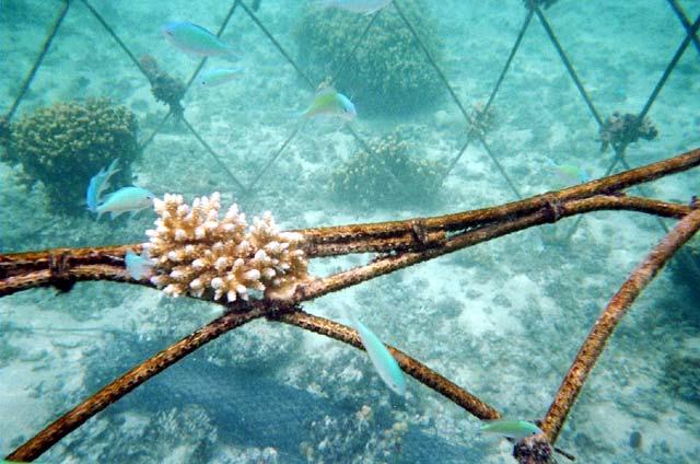
1 GLOBAL CORAL REEF ALLIANCE A non-profit organization for protection and sustainable management of coral reefs Global Coral Reef Alliance, 37 Pleasant Street, Cambridge, MA 02139, USA Telephone: goreau@bestweb.net Web site: BIOROCK CORAL REEF RESTORATION AND SHORE PROTECTION PROJECTS IN MAJURO, REPUBLIC OF THE MARSHALL ISLANDS: PRELIMINARY REPORT Thomas J. Goreau, Erik Hagberg, Doan Trevor, & Michael Trevor INTRODUCTION September The Marshall Islands are critically dependent on the health of their coral reefs: every rock and sand grain on the islands are the remains of coral reef organisms. Only actively growing coral reefs can protect the islands against ocean waves and global sea level rise, and provide fish to feed the people. These crucial services are rapidly deteriorating because global warming is bleaching and killing corals, while also accelerating the spread and virulence of coral-killing diseases. As a result every atoll island has a serious erosion problem, which will get much worse as global sea level rise and storm intensity accelerate, unless the reefs that protect the islands can be grown back. The solutions now being used to protect the shoreline are both costly and ineffective. In order to demonstrate practical solutions to these problems we started three pilot coral reef restoration projects and one pilot shore protection project in Majuro using Biorock Technology in early Biorock technology uses safe low voltage direct electrical current, provided by solar panels, windmills, ocean current turbines, or chargers, to grow solid limestone structures of any size or shape on top of steel construction elements. The limestone rock is typically grown at up to an inch a year, and can be up to three times harder as ordinary concrete. Biorock structures grow constantly in strength, and are self repairing: any damage grows back preferentially. This makes them uniquely suited as frameworks to restore coral reefs and fisheries, and to grow breakwaters for shore protection from erosion. Coral fragments transplanted onto them grow typically 3-5 times faster than normal, and survive extreme stress, such as from abnormally high temperatures,
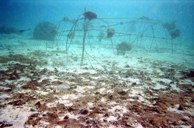
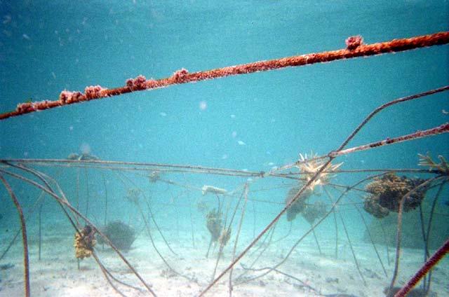
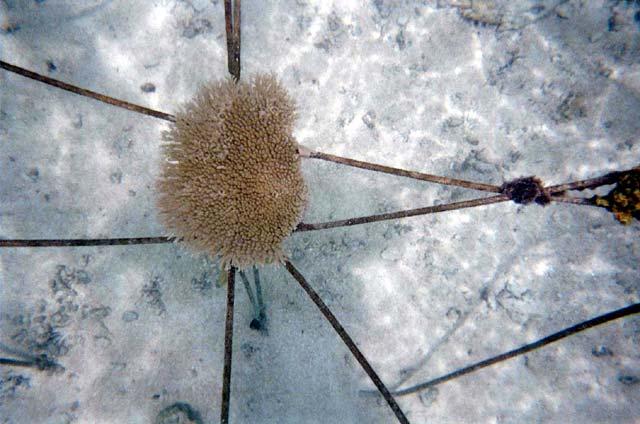
2 16-50 times more than surrounding coral reefs. They have very high rates of baby coral settlement and quickly build up dense populations of reef fish. Because they can be built with many layers of holes of any size or shape, and because corals can be elevated above the bottom and get more light and food, they can support much denser fish populations than even natural reefs. In the Maldives, one of the lowest lying atoll countries in the world, Biorock reefs grown in front of severely eroding beaches turned them into 50 feet of beach growth in a few years. Because these breakwaters slow waves passing through them they do not cause scouring of sand like conventional walls that reflect waves. Biorock breakwaters cost a fraction of rock or cement or gabion seawalls, and create ecotourism resources and fish habitat, making them far superior to conventional methods. Due to the huge untapped tidal current resources of the Marshall Islands, many islands could be protected using local energy resources, but solar and wind energy can also be used. Due to the severe erosion of all Marshallese islands, and the deterioration of the coral reefs, especially in Majuro, these methods are critically needed to protect the islands from rising global temperatures and sea levels. Our projects are small demonstration projects meant to show the potential of the technology to protect the Marshall Island s marine and land resources from global climate change if used on a large scale. These projects were carried out in collaboration between the Global Coral Reef Alliance (an international nongovernmental non-profit organization for research, protection, and sustainable management of coral reefs), Pacfic Aquaculture Cooperatives RMI (a locally registered company developing the Marshall Islands sustainable mariculture resources), and RRE Enterprises (a Marshallese company), with the support of local landowners of Enemanit Island. This report describes the pilot projects that were built in May 2007, and shown in photographs taken in June and August. That is to say after only a few months. If power is maintained the corals will grow very rapidly and attract many more fish in the future. THE PROJECTS A) ENEMANIT REEF RESTORATION PROJECTS Three pilot coral reef restoration projects were built and installed at the southwestern side of Enemanit Island. These projects are powered by solar panels installed on a rack over a small stone dock, and wired to produce 6 volts of power. These structures, varying in size and shape, are growing very slowly, much slower than is typical for such projects, because they are only getting a small trickle of power relative to their size. Broken corals lying on the bottom, which would most likely die from rolling around and being abraded or buried in the sand, were rescued and attached to the structures by either wedging them between steel bars or tying them on with steel tie wire. Power was supplied

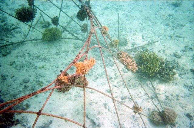
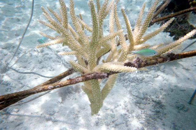
3 directly to the dome, with secondary wires leading to the other two structures, which are consequently getting less power than the other two. One structure has no anode, and so gets the least current of all. The conditions thus cover a range of power levels, as well as heights above the bottom. The three structures put together are getting about as much current as a moderately bright light bulb. Although each is differently shaped, these pilot projects represent only a very small part of the range of structures that could be built to restore coral and fish habitats. 1. STICK CHART REEF RESTORATION PROJECT The first structure built was made in the form of a classic Marshall Islands Stick Chart, a traditional map designed to teach sailors how to navigate between the atolls using the ocean swell to orient themselves. The Biorock stick chart is 10 meters on a side, and made of ordinary steel construction reinforcing bar cut and wired together to replicate a Stick Char. It was laid on top of large shallow coral heads that rise about 3 feet above the sand. No rusting has taken place on the stick chart, and the corals attached to it are growing very well. The corals it is resting on began growing around and over it within days. Fish were immediately attracted.

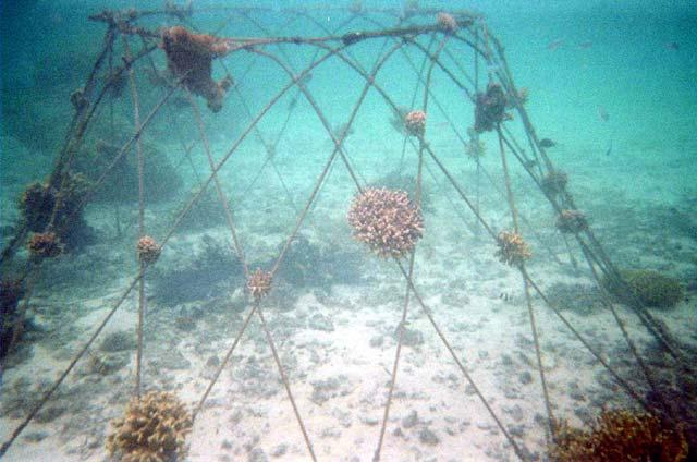
4 2. DOME REEF RESTORATION PROJECT

5 The dome is about 7 feet tall and about 15 feet wide, located in deeper water and is getting the most current. It is located over sand that had no corals and very few fish. The steel framework began to turn white with limestone growth in a day. Coral fragments attached to it quickly cemented themselves on and began to branch. They range in height from sitting on the sand to about 7 feet above it. The corals have proceeded to grow rapidly and attract fish.
6
7

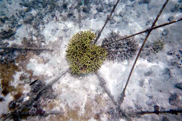
8 3. BOAT REEF RESTORATION PROJECT The boat is the longest and lowest structure, and is receiving the least current because it is furthest from the power source and has no anode of its own, relying on current from the anode in the dome. Corals attached to it are less than three feet above the sand. The structure shows no rusting, the corals have attached themselves and are starting to branch, and fish have been attracted.
9
10
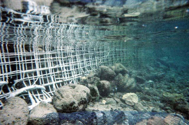
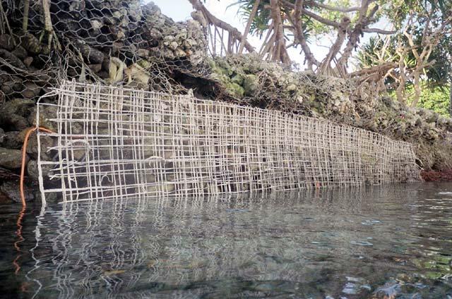
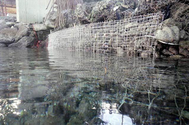
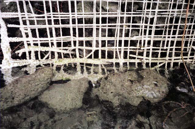
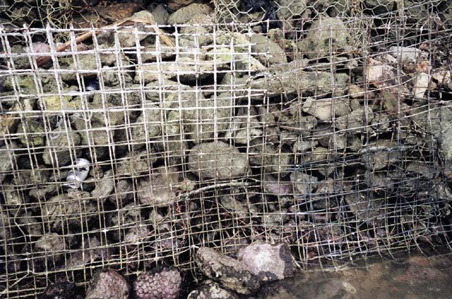
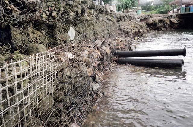
11 B) SHORE PROTECTION PROJECT 4. REIMER S DOCK SHORE PROTECTION PILOT PROJECT The shoreline here is composed of gabion wire baskets filled with rocks. The original gabion wire was uncoated, and quickly rusted and fell apart. It was then replaced with more costly plastic coated wire. However the plastic coating has now cracked or been abraded in many places, so the interior wire is rusting, and many of the wire baskets have broken open, spilling the rocks, and causing the structure to sag. In several places the sand beneath the baskets has been washed away by waves, undermining them and causing all the structures above them to sag and settle. This is widely seen all along the Majuro shoreline. The shore protection project is located along the northern intertidal portion of the Reimer s dock. It consists of old scrap square mesh fencing material that was being thrown out. This has been attached to the outer vertical surface of the dock wall using rebar pins. The mesh is charged by a small battery charger running at 6 volts and several amps, drawing as much power as a dim light bulb. The white mineral growth on this was very rapid, so an additional piece of fencing was added to extend the project. This has grown less because it has had less time and is further from the power source. While the material used in this project was fairly flimsy and only intended as a demonstration, it indicates that with stronger material and more power the entire dock wall could be encased in a solid limestone surface that would end the crumbling and collapse of the dock, and that similar steps could be taken to protect all of the shoreline that is now subject to erosion. Not only would this be far more effective than the current methods now being used to armor the shoreline, it would be far cheaper and permanent.
12
13
14
GLOBAL FISHERIES CRISIS
 NEW DIRECTIONS IN SUSTAINABLE MARICULTURE AND FISHERIES HABITAT RESTORATION UNITED NATIONS COMMISSION ON SUSTAINABLE DEVELOPMENT PARTNERSHIP IN NEW TECHNOLOGIES FOR SMALL ISLAND DEVELOPING STATES May 13
Living Shorelines. Created by: JoAnn Moody & Tina Miller-Way Discovery Hall Programs Dauphin Island Sea Lab
 Living Shorelines Created by: JoAnn Moody & Tina Miller-Way Discovery Hall Programs Dauphin Island Sea Lab Living Shorelines Subject: Life Science Grade Level: 6 th -8 th Time Required: 60 min Key Terms:
Coastal Change and Conflict
 Coastal Change and Conflict Outline of the Topic Contrasting Coasts why do all coasts not look the same? Geology of the coast the impact rock structure has on the coastline Waves Constructive and destructive
Oceans Humans both depend on it and threaten it with their activities
 Oceans Humans both depend on it and threaten it with their activities Oceans Water covers nearly ¾ of the Earth s surface More than 50% of the world s population lives within an hour of the coast Oceans
4/20/17. #31 - Coastal Erosion. Coastal Erosion - Overview
 Writing Assignment Due Monday by 11:59 pm #31 - Coastal Erosion Beach front property! Great View! Buy now at a great price! See main class web pages for detailed instructions Essays will be submitted in
Marine Ecosystems. Aquatic Ecosystems Section 2
 Marine Ecosystems Marine ecosystems are located mainly in coastal areas and in the open ocean. Organisms that live in coastal areas adapt to changes in water level and salinity. Organisms that live in
3.9 FROM ISLANDS TO ATOLLS
 3.9 1 3.9 FROM ISLANDS TO ATOLLS OBJECTIVES The students Listen to a description of the formation of volcanic islands, fringing reefs, barrier reefs, and atolls. Observe and participate in a simulation
FOR PERSONAL USE. Shoreline Erosion BROWARD COUNTY ELEMENTARY SCIENCE BENCHMARK PLAN ACTIVITY ASSESSMENT OPPORTUNITIES. Grade 4 Quarter 1 Activity 9
 activity 9 Shoreline Erosion BROWARD COUNTY ELEMENTARY SCIENCE BENCHMARK PLAN Grade 4 Quarter 1 Activity 9 SC.D.1.2.4 The student knows that the surface of the Earth is in a continuous state of change
Chapter 10 Lecture Outline. The Restless Oceans
 Chapter 10 Lecture Outline The Restless Oceans Focus Question 10.1 How does the Coriolis effect influence ocean currents? The Ocean s Surface Circulation Ocean currents Masses of water that flow from one
OCEANS. Main Ideas. Lesson 2: Ocean Currents Ocean Currents help distribute heat around Earth.
 Oceans Chapter 10 OCEANS Main Ideas Lesson 2: Ocean Currents Ocean Currents help distribute heat around Earth. Lesson 3: The Ocean Shore The shore is shaped by the movement of water and sand. OCEANS SO
Coastal management has lagged behind the growth in population leading to problems with pollution
 Fifty percent of the population of the industrialized world lives within 100 km of a coast. Coastal management has lagged behind the growth in population leading to problems with pollution and natural
Building Coastal Resiliency at Plymouth Long Beach
 Building Coastal Resiliency at Plymouth Long Beach Department of Marine and Environmental Affairs March 30, 2017 Introducing Green Infrastructure for Coastal Resiliency Plymouth Long Beach & Warren s Cove
Winter Culture of Caged Rainbow Trout in the South.
 Winter Culture of Caged Rainbow Trout in the South. Forrest Wynne, State Extension Specialist for Aquaculture, Kentucky State University Cooperative Extension Program, Graves County Extension Office, 251
Winter Culture of Caged Rainbow Trout in the South.
 Winter Culture of Caged Rainbow Trout in the South. Forrest Wynne, Aquaculture Extension Specialist, Kentucky State University Cooperative Extension Program, Graves County Cooperative Extension Service
LAB: WHERE S THE BEACH
 Name: LAB: WHERE S THE BEACH Introduction When you build a sandcastle on the beach, you don't expect it to last forever. You spread out your towel to sunbathe, but you know you can't stay in the same spot
STATUS REPORT FOR THE SUBMERGED REEF BALL TM ARTIFICIAL REEF SUBMERGED BREAKWATER BEACH STABILIZATION PROJECT FOR THE GRAND CAYMAN MARRIOTT HOTEL
 August 23 STATUS REPORT FOR THE SUBMERGED REEF BALL TM ARTIFICIAL REEF SUBMERGED BREAKWATER BEACH STABILIZATION PROJECT FOR THE GRAND CAYMAN MARRIOTT HOTEL performed by Lee E. Harris, Ph.D., P.E. Consulting
Lee E. Harris, Ph.D., P.E. Assoc. Professor of Ocean Engineering. Doug Bowlus and Ashley Naimaster Ocean Engineering Graduate Students
 FLORIDA TECH OCEAN ENGINEERING PROFESSOR LEE HARRIS AND HIS GRADUATE STUDENTS ASSIST WITH POST-HURRICANE IVAN CORAL REEF RESTORATION IN THE CAYMAN ISLANDS Lee E. Harris, Ph.D., P.E. Assoc. Professor of
Assessment of flooding on low-elevation reef-lined coasts
 Assessment of flooding on low-elevation reef-lined coasts Ap van Dongeren, Deltares, Delft, The Netherlands With Curt Storlazzi, USGS, Santa Cruz, USA Impact on coral reef-lined islands and coasts Coral
COASTAL MANAGEMENT AND PROTECTION METHODS! 1
 COASTAL MANAGEMENT AND PROTECTION METHODS! 1 Strategy What it does Cons Pros Examples SOFT ENGINEERING: The use of ecological principles and practices to reduce erosion and achieve the stabilization and
Lecture Outlines PowerPoint. Chapter 15 Earth Science, 12e Tarbuck/Lutgens
 Lecture Outlines PowerPoint Chapter 15 Earth Science, 12e Tarbuck/Lutgens 2009 Pearson Prentice Hall This work is protected by United States copyright laws and is provided solely for the use of instructors
International Rainbow Warrior Divers Association ( IRWADA )
") International Rainbow Warrior Divers Association ( IRWADA ) Nursery of artificial reefs in Tulamben, northeast Bali Prologue : Indonesia has 581 of the worlds` 793 known reef building coral species, i.e.
International Rainbow Warrior Divers Association ( IRWADA ) Nursery of artificial reefs in Tulamben, northeast Bali Prologue : Indonesia has 581 of the worlds` 793 known reef building coral species, i.e.
* Appalachian Mountains -the mountain range in the Eastern U.S. which terminates in north-central Alabama
 MR. SAND TEACHER'S MANUAL INTRODUCTION: Although Mr. Sand is a cartoon presentation that is attractive to children (of all ages), the material is technically accurate and quite significant to our understanding
COASTAL HAZARDS. What are Coastal Hazards?
 COASTAL HAZARDS What are Coastal Hazards? Hazards in the New Jersey coastal zone include unavoidable risks to life and property generated by: coastal flooding, waves, high winds and waves, short-term and
Natural Bridges Field Trip Activity
 Natural Bridges Field Trip Activity This is due in class on MONDAY- March 1 - not in sections! Name TA: NOTE ON THE GRADING OF THIS ASSIGNMENT: Many of the questions below (especially in the tidepool part)
Chapter 12: Coasts (after a brief review of Tides)
") Chapter 12: Coasts (after a brief review of Tides) 1 Questions from previous classes: What happens when a wave meets a current? wave = people walking current = bus If wave goes with the current, the wave
Chapter 12: Coasts (after a brief review of Tides) 1 Questions from previous classes: What happens when a wave meets a current? wave = people walking current = bus If wave goes with the current, the wave
Lessons Learned from Shoreline Protection Demonstration Projects in Southwest Louisiana
 Lessons Learned from Shoreline Protection Demonstration Projects in Southwest Louisiana Tommy McGinnis and Maggie Luent CPRA Operations Division Lafayette Regional Office State of the Coast June 01, 2018
Geology of the Hawaiian Islands
 Geology of the Hawaiian Islands Class 24 8 April 2004 Any Questions? Rise and fall of sea level and its effect on Hawai`i Sea level Has fluctuated up and down many times in the geologic past Evidence?
4/20/17. #32 - Coastal Erosion Case Histories - Lake Michigan
 Writing Assignment Due Monday by 11:59 pm #32 - Coastal Erosion Case Histories - Lake Michigan See main class web pages for detailed instructions Submit papers Illinois Compass No copying: Compass will
Our Council s Own: Oceanography Cadette/Senior/Ambassador Badge
 Our Council s Own: Oceanography Cadette/Senior/Ambassador Badge Oceanography: The science that deals with oceans, the delimitation of their extent and depth, the physics and chemistry of their water, marine
Earth Science Chapter 16 Section 3 Review
 Name: Class: Date: Earth Science Chapter 16 Section 3 Review Multiple Choice Identify the choice that best completes the statement or answers the question. 1. The movement of water that parallels the shore
Shoreline Erosion Control Failures and How To Avoid Them
 2008 Illinois Lake Management Association Shoreline Erosion Control Failures and How To Avoid Them by: Hank Sutton, President, Lake Rip Rap, Inc. www.lakeriprap.com - www.macoupinboats.com Setting the
The Sea Geography Notes JC-Learn. JC-Learn. Geography Notes The Sea. 1 P a g e
 JC-Learn Geography Notes The Sea 1 P a g e The Sea *Here, you can choose to study the chapter on glaciation or the one on the sea, or even both, because whenever these topics come up in the Junior Cert
EMERGENCY WORK AT REPOS BEACH AUROVILLE REPORT 24 th SEPTEMBER 2013
 EMERGENCY WORK AT REPOS BEACH AUROVILLE REPORT 24 th SEPTEMBER 2013 Satprem Maïni, Lara Davis Auroville Earth Institute BACKGROUND The erosion of the sand beaches north of Pondicherry is the result of
1 Shoreline Erosion and Deposition
 CHAPTER 12 1 Shoreline Erosion and Deposition SECTION Agents of Erosion and Deposition BEFORE YOU READ After you read this section, you should be able to answer these questions: What is a shoreline? How
REVETMENTS. Purposes and Operational Constraints. Purposes Erosion control o o. Revetment Design 4/5/2016. CE A676 Coastal Engineering
 REVETMENTS Ijsseldam, the Netherlands Orson P. Smith, PE, Ph.D. Instructor Purposes and Operational Constraints Purposes Erosion control o o Embankment Toe protection for a seawall, retaining wall or other
Define the key terms: - Abrasion - Attrition - Hydraulic action - Solution. Y11 Coasts
 Define the key terms: - Abrasion - Attrition - Hydraulic action - Solution Abrasion caused by waves picking up material which is forced against the cliff face wearing it away Attrition where stones and
2018 Beach Preservation Project Information
 QUICK FACTS Beach Renourishment to begin late April 2018 o U.S. Army Corps of Engineers project o Project Area: 8 th St. E. to end of E. Ashley Ave. o Project Length: 2 miles o Cost: $10,900,000 o Funding:
SALINITY. It's the amount of dissolved salts the water contains.
 AQUATIC ECOSYSTEMS SALINITY The types of organisms in an aquatic ecosystem depend upon the water s Salinity. It's the amount of dissolved salts the water contains. Salinity determines the two main aquatic
SACO RIVER AND CAMP ELLIS BEACH SACO, MAINE SECTION 111 SHORE DAMAGE MITIGATION PROJECT APPENDIX F ECONOMIC ASSESSMENT
 SACO RIVER AND CAMP ELLIS BEACH SACO, MAINE SECTION 111 SHORE DAMAGE MITIGATION PROJECT APPENDIX F ECONOMIC ASSESSMENT Department of the Army New England District, Corps of Engineers 696 Virginia Road
ALTERNATIVES FOR COASTAL STORM DAMAGE MITIGATION
 ALTERNATIVES FOR COASTAL STORM DAMAGE MITIGATION Dave Basco Old Dominion University, Norfolk, Virginia, USA National Park Service Photo STRUCTURAL (changes to natural, physical system) hardening (seawalls,
Coasts. 1. Coastal Processes. 1.1 Coastal erosion. 1.2 Sediment transport. Coastal Processes and Landforms. i. Hydraulic action
 Coasts Coastal Processes and Landforms 1. Coastal Processes 1.1 Coastal erosion i. Hydraulic action When waves strike against a rock surface, the waves trap air in the rock joints. This air is compressed
INTRODUCTION SEAS AND OCEANS: A PRECIOUS RESOURCE KEY FACTS
 6 ~ SEAS FOR LIFE INTRODUCTION SEAS AND OCEANS: A PRECIOUS RESOURCE We all benefit from our seas and oceans. In addition to the more traditional uses like transport, fishing, aquaculture, tourism and recreation,
APPENDIX A. F107 & 380 Lines OYSTER RIVER DURHAM, NH
 APPENDIX A F107 & 380 Lines OYSTER RIVER DURHAM, NH 1. The design and proposed construction of this crossing is shown on the attached PSNH Transmission Business Drawing entitled DOUBLE CKT F107 & 380 BETWEEN
Chapter. The Dynamic Ocean
 Chapter The Dynamic Ocean An ocean current is the mass of ocean water that flows from one place to another. 16.1 The Composition of Seawater Surface Circulation Surface Currents Surface currents are movements
Unit 11 Lesson 2 How Does Ocean Water Move? Copyright Houghton Mifflin Harcourt Publishing Company
 Unit 11 Lesson 2 How Does Ocean Water Move? Catch a Wave A wave is the up-and-down movement of surface water. Catch a Wave Catch a Wave (wave effects) Surface waves are caused by wind pushing against
SHOREHAM BEACH LOCAL NATURE RESERVE
 SHOREHAM BEACH LOCAL NATURE RESERVE Coastal Geography Education Programme 2014-15 S. Savage 2014 COASTAL GEOGRAPHY OPPORTUNITIES Shoreham Beach Shoreham Beach is a shingle spit formed over many centuries
Coral Reefs N Q U. Visit for thousands of books and materials.
 Coral Reefs A Reading A Z Level N Leveled Book Word Count: 615 N Q U Written by Paula Schricker Visit www.readinga-z.com for thousands of books and materials. www.readinga-z.com Photo Credits: Front cover:
4/20/17. #30 - Coastlines - General Principles Coastlines - Overview
 Writing Assignment Due one week from today by 11:59 pm See main class web pages for detailed instructions Essays will be submitted in Illinois Compass (instructions later) Pick one: Earthquakes, tsunamis,
Deep-water orbital waves
 What happens when waves approach shore? Deep-water orbital waves Fig. 9.16, p. 211 Wave motion is influenced by water depth and shape of the shoreline wave buildup zone surf zone beach Wave base deepwater
ALTERNATIVES FOR COASTAL STORM DAMAGE MITIGATION AND FUNCTIONAL DESIGN OF COASTAL STRUCTURES
 The University of the West Indies Organization of American States PROFESSIONAL DEVELOPMENT PROGRAMME: COASTAL INFRASTRUCTURE DESIGN, CONSTRUCTION AND MAINTENANCE A COURSE IN COASTAL DEFENSE SYSTEMS I CHAPTER
1.5 How do ocean waves and currents change the face of coastal areas? (Chapter 3)
") 1.5 How do ocean waves and currents change the face of coastal areas? (Chapter 3) 1. Hydraulic Action/Pressure - air being forced into crack in rocks. 2. Corrosion (Solution) Minerals such as calcium carbonate
1.5 How do ocean waves and currents change the face of coastal areas? (Chapter 3) 1. Hydraulic Action/Pressure - air being forced into crack in rocks. 2. Corrosion (Solution) Minerals such as calcium carbonate
The Case of the Disappearing Shoreline
 Name The Case of the Disappearing Shoreline Humans change the earth's climate in many ways. One change is the increase of carbon dioxide in the atmosphere. As we burn more fossil fuels, we release more
Legal, scientific and engineering aspects of Integrated Coastal Zone Management (ICZM) in Poland
 in Poland") Gdańsk, March 21 st 2013 Legal, scientific and engineering aspects of Integrated Coastal Zone Management (ICZM) in Poland Rafał Ostrowski Institute of Hydro-Engineering of the Polish Academy of Sciences
Gdańsk, March 21 st 2013 Legal, scientific and engineering aspects of Integrated Coastal Zone Management (ICZM) in Poland Rafał Ostrowski Institute of Hydro-Engineering of the Polish Academy of Sciences
Living Shorelines Non-structural Erosion Control Practices Rhode Island Land & Water Summit, 2014
 Living Shorelines Non-structural Erosion Control Practices Rhode Island Land & Water Summit, 2014 D. Steven Brown (1) Kevin Ruddock (1) Rhonda Smith (2) The Nature Conservancy United States Fish and Wildlife
Figure 4, Photo mosaic taken on February 14 about an hour before sunset near low tide.
 The Impact on Great South Bay of the Breach at Old Inlet Charles N. Flagg and Roger Flood School of Marine and Atmospheric Sciences, Stony Brook University Since the last report was issued on January 31
Oceans in Motion: Waves and Tides
 Oceans in Motion: Waves and Tides Waves Waves are among the most familiar features in the ocean. All waves work similarly, so although we are talking about ocean waves here, the same information would
There are many different kinds of beaches which are generally characterized by the dominance of waves, tides, rivers and currents, and in particular
 Fig. 11-11, p. 253 There are many different kinds of beaches which are generally characterized by the dominance of waves, tides, rivers and currents, and in particular differ by the amount of energy, which
Importance of Dunes Sign. Kim Scarola Suzanne Merrick Ariana Perez Johanna Mead
 Importance of Dunes Sign Kim Scarola Suzanne Merrick Ariana Perez Johanna Mead What role do dunes play in our coastlines? Part of a system of sand deposits and withdraws that helps keep the sand on our
ATLANTIC COUNTY 2006 to 2008
 ATLANTIC COUNTY 2006 to 2008 The Atlantic County oceanfront shoreline consists of three barrier islands where the northern one, Little Beach Island and a third of the second, Brigantine Island, are undeveloped
Overview. What are Corals?
 Overview Coral Reefs extend back over 500 m.y. Grow in tropical seas with normal salinity Support a great variety of plant and animal life Cover less than 0.2% of sea floor Contain about 25% of marine
Estuarine Shoreline Stabilization
 Estuarine Shoreline Stabilization Property Owner s Guide to Determining the Most Appropriate Stabilization Method Estuarine shorelines are dynamic features that experience continued erosion. Land is lost
Imagine that you can see a side view of a wave as it approaches a beach. Describe how the wave changes as the wave approaches the beach.
 Geology 101 Name Reading Guide for Ch. 19: Shores and Coastal Processes (p. 612) Waves, Currents, and Tides (p. 614) Waves and Currents (p. 614) Imagine that you can see a side view of a wave as it approaches
ALTERNATIVE SHORELINE TREATMENT GUIDELINE
 ALTERNATIVE SHORELINE TREATMENT GUIDELINE Prepared By: Galveston Bay Foundation 17324-A Highway 3 Webster, TX 77598 281-332-3381 www.galvbay.org May 9, 2003 17324-A Highway 3, Webster, TX 77598 Phone 281-332-3381
Unit 1 Lesson 2: Reef Surveys and Deep Worker. When Coral Reefs Get in the Way...
 Unit 1 Lesson 2: Reef Surveys and Deep Worker Lesson Objectives: Upon completion of this unit students should gain knowledge and understanding of: factors that cause physical damage to coral reefs the
Beaches Unit (4.5 pts)
") T. James Noyes, El Camino College Beaches Unit (Topic 6A) page 1 Name: Section: Beaches Unit (4.5 pts) Beaches and Shorelines Are Always Changing Waves are slowly and inexorably altering the shoreline,
T. James Noyes, El Camino College Beaches Unit (Topic 6A) page 1 Name: Section: Beaches Unit (4.5 pts) Beaches and Shorelines Are Always Changing Waves are slowly and inexorably altering the shoreline,
CROSS-SHORE SEDIMENT PROCESSES
 The University of the West Indies Organization of American States PROFESSIONAL DEVELOPMENT PROGRAMME: COASTAL INFRASTRUCTURE DESIGN, CONSTRUCTION AND MAINTENANCE A COURSE IN COASTAL DEFENSE SYSTEMS I CHAPTER
Oceans - Laboratory 12
 Oceans - Laboratory 12 (Name) How do ocean waves form? All waves are disturbances of a fluid medium through which energy is moved (Davis, 1997). Ocean waves travel on the interface between oceans and the
The Sand Beaches of New Hampshire and Maine
 The Sand Beaches of New Hampshire and Maine Beach Preservation and Erosion Control Photographs provided by Joe Kelly and Steve Adams Cover photo: Reid State Park, ME Introduction The sand beaches of New
RE: Hurricane Matthew Beach Damage Assessment and Recommendations [CSE 2416]
![RE: Hurricane Matthew Beach Damage Assessment and Recommendations [CSE 2416]](/thumbs/83/87675702.jpg "RE: Hurricane Matthew Beach Damage Assessment and Recommendations [CSE 2416]") October 25, 2016 Iris Hill Town Administrator Town of Edisto Beach 2414 Murray St Edisto Beach SC 29438 RE: Hurricane Matthew Beach Damage Assessment and Recommendations [CSE 2416] Dear Iris, Hurricane
October 25, 2016 Iris Hill Town Administrator Town of Edisto Beach 2414 Murray St Edisto Beach SC 29438 RE: Hurricane Matthew Beach Damage Assessment and Recommendations [CSE 2416] Dear Iris, Hurricane
The Dynamic Coast. Right Place Resources. A presentation about the interaction between the dynamic coast and people
 The Dynamic Coast Houses threatened by coastal erosion in California Right Place Resources A presentation about the interaction between the dynamic coast and people For the rest of the presentations in
Marginal Marine Environments
 Marginal Marine Environments Delta: discrete shoreline protuberances formed where rivers enter oceans, semi-enclosed seas, lakes or lagoons and supply sediment more rapidly than it can be redistributed
HARBOR INFRASTRUCTURE INVENTORIES West Harbor, OH
 HARBOR INFRASTRUCTURE INVENTORIES West Harbor, OH Harbor Location: West Harbor is located on the southern shore of Lake Erie in the township of Catawba Island, OH about 50 miles east of Toledo, OH. Authority:
Anguilla. Wise practices for coping with. i b bea n Se a
 Wise practices for coping with Anguilla Car i b bea n Se a Department of Fisheries and Marine Resources, Anguilla Department of Physical Planning, Anguilla University of Puerto Rico, Sea Grant College
An Unwelcome Newcomer
 An Unwelcome Newcomer An Unwelcome Newcomer This article is provided courtesy of the American Museum of Natural History. million eggs each year. Then Invasion of the Zebra Mussels the young mussels float
Apostle Islands National Seashore
 Apostle Islands National Seashore David Speer & Phillip Larson October 2 nd Fieldtrip Report Table of Contents Introduction 1 Stop 1: Apostle Island Boat Cruise 1 Stop 2: Coastal Geomorphology 5 Stop 3:
OECS Regional Engineering Workshop September 29 October 3, 2014
 B E A C H E S. M A R I N A S. D E S I G N. C O N S T R U C T I O N. OECS Regional Engineering Workshop September 29 October 3, 2014 Coastal Erosion and Sea Defense: Introduction to Coastal Dynamics David
Coastal areas have become increasingly under threat in recent years. Climate change is having a huge effect on coastal areas, making them much more
 Why are some coastal environments under threat? Coastal areas have become increasingly under threat in recent years. Climate change is having a huge effect on coastal areas, making them much more likely
Oceanic Society Reef Research Team: Nicole Crane, Avigdor Abelson, Peter Nelson, Giacomo Bernardi, Michelle Paddack, Kate Crosman
 The coral reef of Tamil (Yap, FSM): Preliminary ecological assessment of reef state and fish assemblages, and potential of conservation for sustainable use Report compiled by vigdor belson, Peter Nelson
GONE! Coastal Erosion Happens During Storms! Why Worry About Coastal Setbacks? Goals for Today
 RI Regulatory Setbacks & Buffers: Coastal Zone Management Issues New England Onsite Wastewater Training Program @ URI OWT 155 November 21, 2013 Goals for Today Understand the impacts of storms, coastal
Haitian Curriculum Fourth Grade Science Lesson Plan Coral Reefs in Haiti
 Haitian Curriculum Fourth Grade Science Lesson Plan Coral Reefs in Haiti Content/Theme: Coral Reefs in Haiti/Ecosystems Grade: Fourth Primary Benchmark: SC.4.L.17.4 Recognize ways plants and animals, including
The Study of Coastal Erosion on the Happisburgh Coast
 PT-YR: Coastal and Ocean Engineering ENGI.8751 Undergraduate Student Forum Faculty of Engineering and Applied Science, Memorial University, St. john s, NL, Canada March, 2013 Paper Code. (PT-2013 - Roberts)
VIMS CCRM Coastal Management Decision Tools. Decision Tree for Undefended Shorelines and Those with Failed Structures
 VIMS CCRM Coastal Management Decision Tools Decision Tree for Undefended Shorelines and Those with Failed Structures Center for Coastal Resources Management Virginia Institute of Marine Science Gloucester
OCN 201: Coastal Erosion and Beach Loss
 OCN 201: Coastal Erosion and Beach Loss This lecture was prepared from slides and notes kindly provided by: Prof. Chip Fletcher Department of Geology and Geophysics, University of Hawaii Chip Fletcher
For more information or permission to reprint slides, please contact Donna Milligan at 1
 For more information or permission to reprint slides, please contact Donna Milligan at milligan@vims.edu 1 For more information or permission to reprint slides, please contact Donna Milligan at milligan@vims.edu
Life at its Peak of Exuberance: Coral Reefs and Tropical Rainforests
 Life at its Peak of Exuberance: Coral Reefs and Tropical Rainforests Note: These links do not work. Use the links within the outline to access the images in the popup windows. This text is the same as
HARBOUR SEDIMENTATION - COMPARISON WITH MODEL
 HARBOUR SEDIMENTATION - COMPARISON WITH MODEL ABSTRACT A mobile-bed model study of Pointe Sapin Harbour, in the Gulf of St. Lawrence, resulted in construction of a detached breakwater and sand trap to
170 points. 38 points In your textbook, read about modern oceanography. For each item write the word that meets the description.
 Ch 15 Earth s Oceans SECTION 15.1 An Overview of Oceans 38 points In your textbook, read about modern oceanography. For each item write the word that meets the description. (5 points) 1. German research
RI Regulatory Setbacks & Buffers: Coastal Management Issues
 RI Regulatory Setbacks & Buffers: Coastal Management Issues New England Onsite Wastewater Training Program @ URI OWT 155 - November 29, 2012 James Boyd - Coastal Policy Analyst Photo: October 30, 2012
Ocean Motion Notes. Chapter 13 & 14
 Ocean Motion Notes Chapter 13 & 14 What is a Wave? Wave: movement of energy through a body of water How are Waves Caused? Caused mostly by wind Wind blowing on the water transmits energy to the water Size
HARBOR INFRASTRUCTURE INVENTORIES Marquette Harbor, Michigan
 HARBOR INFRASTRUCTURE INVENTORIES Marquette Harbor, Michigan Harbor Location: Marquette Harbor is located in Marquette Bay on the south shore of Lake Superior, 160 miles west of Sault Ste. Marie, MI and
Coastal Processes Day Criccieth
 Coastal Processes Rivers (Conwy) Rivers (Peris) Urban Studies Lowland Glaciation Tourism and National Parks Soils Sand Dunes Upland Glaciation Rural Settlements The Centre and Staff Fieldwork Equipment
Figure 1. Schematic illustration of the major environments on Mustang Island.
 STOP #1: PACKERY CHANNEL BEACH TO BAY We will start this field guide near the north jetty of Packery Channel and hike across the island to Corpus Christi Bay (fig. 1). The island emerges from the Gulf
13. TIDES Tidal waters
 Water levels vary in tidal and non-tidal waters: sailors should be aware that the depths shown on the charts do not always represent the actual amount of water under the boat. 13.1 Tidal waters In tidal
Beach Profiles: Monitoring Sea Level Rise. Student Activity Sheet. Name Date Class
 Beach Profiles: Monitoring Sea Level Rise Student Activity Sheet Name Date Class A shoreline is the area where the water and land meet. This is where we find beach: areas where sediments (sand or other
Shoreline Response to an Offshore Wave Screen, Blairgowrie Safe Boat Harbour, Victoria, Australia
 Shoreline Response to an Offshore Wave Screen, Blairgowrie Safe Boat Harbour, Victoria, Australia T.R. Atkins and R. Mocke Maritime Group, Sinclair Knight Merz, P.O. Box H615, Perth 6001, Australia ABSTRACT
VENICE LOCAL COASTAL PROGRAM UPDATE: COASTAL HAZARDS WELCOME
 VENICE LOCAL COASTAL PROGRAM UPDATE: COASTAL HAZARDS WELCOME 1 Introducing the Team Hosted by the Department of City Planning and grant funded in part by the California Coastal Commission 2 Workshop Purpose
Australian Coastal Councils Conference
 Australian Coastal Councils Conference Kiama March 2019 Where Has My Beach Gone? (and what can I do about it?) Dr Andrew McCowan Water Technology Where Has My Beach Gone? Where Has My Beach Gone? Where
Cove Point Beach Restoration: Utilization of a Spawning Habitat by Horseshoe Crabs (Limulus polyphemus)
") Cove Point Beach Restoration: Utilization of a Spawning Habitat by Horseshoe Crabs (Limulus polyphemus) Paul Bushmann, Jessica Peterson, Bethany Enyeart and Deborah Smith Anne Arundel Community College
Cove Point Beach Restoration: Utilization of a Spawning Habitat by Horseshoe Crabs (Limulus polyphemus) Paul Bushmann, Jessica Peterson, Bethany Enyeart and Deborah Smith Anne Arundel Community College
Water Resources Report RKLD Annual Meeting July 30, 2016
 Water Resources Report RKLD Annual Meeting 2016 July 30, 2016 Topics Hydrology Report Indianford Dam trash rack cleanout performance Experimental Project update Review of PAS project Twin floods- 1 to
Name Class Date. Use the terms from the following list to complete the sentences below. Each term may be used only once. Some terms may not be used.
 Assessment Chapter Test B The Movement of Ocean Water USING KEY TERMS Use the terms from the following list to complete the sentences below. Each term may be used only once. Some terms may not be used.