Living Shorelines Non-structural Erosion Control Practices Rhode Island Land & Water Summit, 2014
|
|
|
- Oliver Leonard
- 6 years ago
- Views:
Transcription


")


1 Living Shorelines Non-structural Erosion Control Practices Rhode Island Land & Water Summit, 2014 D. Steven Brown (1) Kevin Ruddock (1) Rhonda Smith (2) The Nature Conservancy United States Fish and Wildlife Service Project Supported By: Erika Nortemann, TNC


2 Outline Setting the Stage Traditional Protection Strategies Structural vs. non-structural Evolving Shoreline Practices Concepts and techniques Narrow River Pilot Project Site suitability Permits and regulations Project Timeline Erika Nortemann, TNC
 New challenges Sea level rise Wetlands can keep pace with up to 2.")

3 Setting the Stage Rhode Island s changing coastline Historical habitat loss 50% decrease in saltmarsh habitat, 4,000 acres (Bertness 2006) 91% loss of shellfish reef habitat, 750 acres (Brown 2013) New challenges Sea level rise Wetlands can keep pace with up to 2.5 mm of sea-level rise per year Coastal erosion Accelerated by storm surge, wave energy, and chronic human-use impacts such as boat wakes Image: wetland peat beneath an exposed tidal flat, evidence of sea-level rise and landward migration of the shoreline, Brown, TNC Image: eroding fringe marsh and remnant peat colonized by mussels, evidence of marsh loss, Brown, TNC
4 Marsh Erosion is Natural in a balanced state Waves and Wakes Tidal Currents Sediment Supply Sediment Movement Sediment Supply Erosion or Accretion Sediment Type Biological Stabilization (Mussels) and Destabilization (Crabs) Sediment Mobility Brown, TNC


5 Shoreline Protection Hard/Structural Practices Definition Erosion control practices using hard structures that armor and stabilize the shoreline Examples Bulkheads, concrete seawalls, rip-rap, groins, breakwaters, stone reinforcement 30% of RI s shoreline is armored (Hehre, 2007; Freedman, 2012) 30% of Narragansett Bay 20% of South County and Washington County Wooden bulkhead, VIMS Rock gabion, UK NE Stone Riprap, VIMS
 Potential")

6 Shoreline Protection Hard/Structural Practices Potential Benefits Can slow down rates of landward erosion, particularly in high energy environments (NOAA, 2009) Potential Drawbacks Often exacerbates erosion seaward of hardened structure Impacts wetland and intertidal habitat Interferes with coastal access Diminishes coastal processes and services
7 Shoreline Protection Detroit riprap Salmon Recovery Partnership

8 Shoreline Protection Hard/Structural Practices Hard structures preclude landward migration of tidal wetlands, Harold Burrell
9 Shoreline Protection Soft/Non-structural Definition Shoreline erosion control and restoration practices using only plantings and organic materials to restore, protect or enhance the natural shoreline environment Examples Vegetation plantings (marsh, submerged aquatic vegetation, dune grasses), coir fiber logs and matting, coir wattle, oyster shell substrate, live oysters and ribbed mussels

10 Shoreline Protection Soft/Non-structural Potential Benefits Reduce bank erosion and property loss Provide an attractive natural appearance Improve marine habitat & spawning areas Improve water quality and clarity Potential Drawbacks Not suitable for high energy environments Requires ongoing maintenance Typically requires trained contractors who may be less familiar with soft stabilization techniques


11 Brown, TNC Coir Log Warning! Use only premium coir logs Re-wrap logs in high fiber matting Don t spear the logs, double stake on either side Secure stakes with nylon not fiber rope Don t place logs directly in front of marsh banks, must be set at least 2-ft from bank

12 Protection Strategies Soft/Non-structural What not to do!


13 What to do! DELSI project Goal: develop strategies for Delaware Bay that incorporate local native vegetation and shellfish Design: installed multiple configurations of coir log and mat Results: vegetative treatments attenuated waves, reduced erosion, trapped sediments, produced micro-phytobenthos, attracted ribbed mussels Optimal Configuration: two rows of logs over mat with shell bags in front Kreeger, DELSI

14 Coir logs DELSI design
 Reduces")

. C.")
15 Shellfish Reefs Natural integration into saltmarsh habitat Enhance sedimentation Sedimentation is a factor of sediment supply and reef design (height, width) Reduces re-suspension and improves water clarity Not the solution to shoreline protection but can protect marsh habitat and enhance ecosystem services (e.g., fish production, denitrification) A. B. C. A. Oyster reef and B. ribbed mussel reef complex associate with saltmarsh habitat ( Brown, TNC). C. Conceptual plan for living shoreline practices ( DELSI).
 Nutrient removal assimilation, denitrification, burial")
 Wave height reduced by 51-90 Wave energy")
16 Shellfish Reefs Ecosystem Services Habitat enhancement complexity and vertical structure provides food and refuge, stimulates abundance and diversity $1,669 to $14,170 acre-year (Grabowski & Peterson 2007) Nutrient removal assimilation, denitrification, burial eutrophication mitigation - $560 to $2,719 acre-year (Kellog 2011) Benthic stabilization erosion prevention, sediment enhancement and deposition, nutrient deposition $14,574 to $34,817 acre-year (Kroeger and Guannel 2013) Wave height reduced by Wave energy reduced by 76-99
: 56 to 122 g m - 2 /week Low relief reefs (15 cm): 22 to 36 g m -")

17 Vertically Complex Reefs Sedimentation rates High relief reef attenuated waves and enhanced sedimentation landward of reefs High relief reefs (50 cm): 56 to 122 g m - 2 /week Low relief reefs (15 cm): 22 to 36 g m - 2 /week Varies by sedimentary landscape Oyster settlement and survival was a magnitude higher on high relief versus low relief reefs Materials needed for 50-ft. oyster sill, Brown, TNC. Recruitment After 18 months After 6 months


18 Erika Nortemann, TNC Oyster Sill Bagged Shell


19 Erika Nortemann, TNC Oyster Sill Bagged Shell
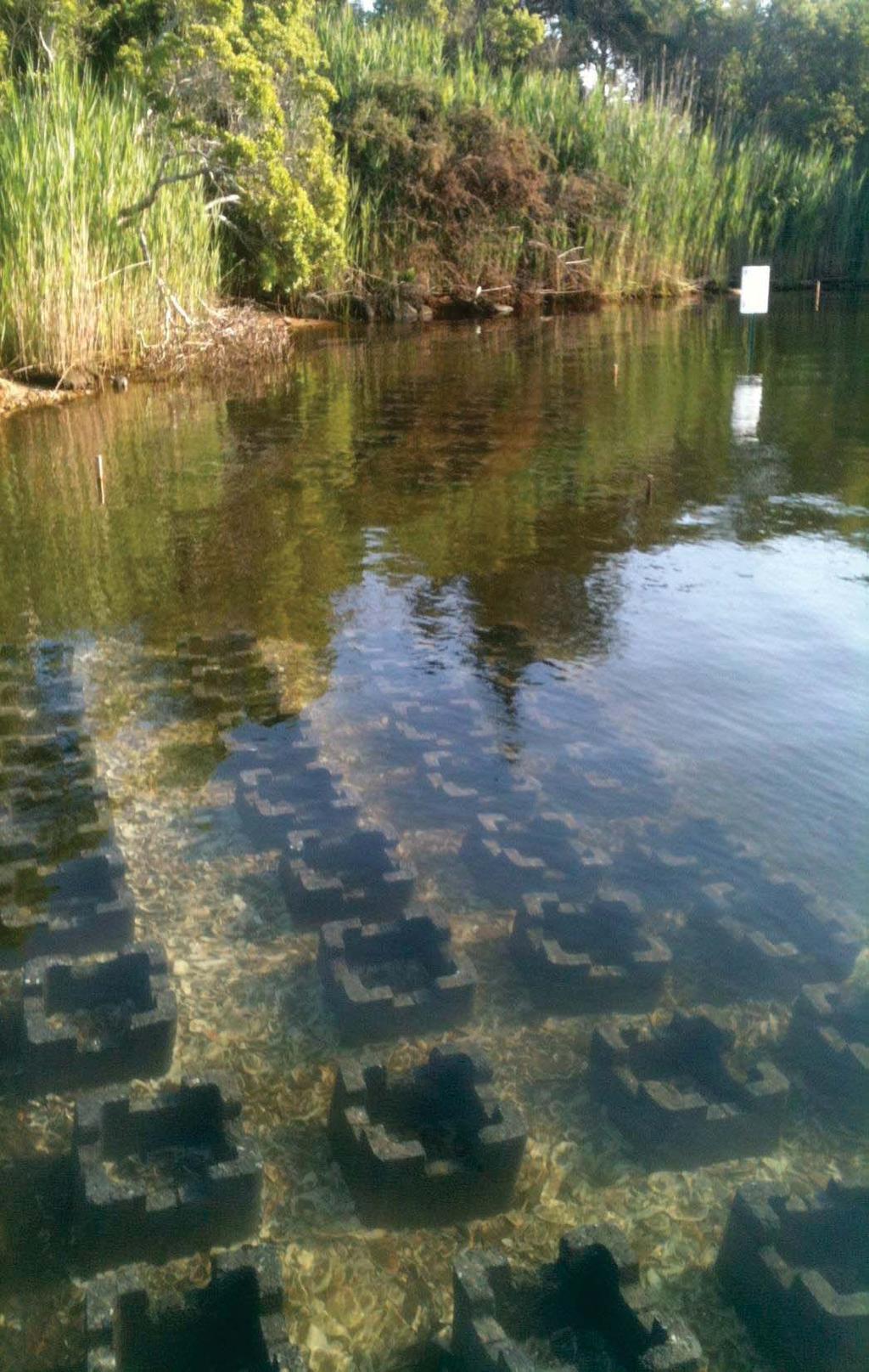
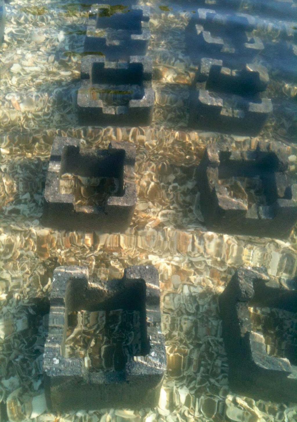

20 Alternative Substrates Oyster Castles


21 Erika Nortemann, TNC Alternative Substrates Oyster Castles

22 Erika Nortemann, TNC Alternative Substrates Oyster Castles

23 Erika Nortemann, TNC Alternative Substrates Oyster Castles

, as well as its location along the 1D")

24 Shellfish Reef Design Wave Attenuation Nearshore Waves Tool Attenuation is a function of the incident wave height, reef physical characteristics (height, crest and base width), as well as its location along the 1D profile Reefs close to the water surface can be quite efficient breakwaters and transmit 3% of the incident wave height 24

 Adopted from Scyphers,")
25 Shellfish Reef Design Wave Attenuation Greater wave dissipation associate with wider reefs and reefs higher than MSL (Beck, 2011) Adopted from Scyphers,

26 Shoreline Strategies Tradeoffs between Structural and Non-Structural Trade-offs Wave characteristics Prevailing tides Distance to shore Slope Bathymetry Numerous site selection tools available DELSI model SCDNR model VIMS site checklist VIMS,
27 Project Costs Includes fabrication, transport, and installation DELSI Living Shoreline (coir logs, plugs, shell bags) Estimated $50 to $100 per linear ft. Shellfish Reef Estimated $5 to $150 per linear ft. Reef Ball $54 per linear ft. Oyster Castle $45 per linear ft. Oyster Breaks $112 per linear ft. Oyster Shell Bags $5 per linear ft. Marsh Stone Sill $300to $480 27


28 Narrow River Shoreline Protection Project Problem incremental loss of low marsh USFWS and TNC erosion study documented: Accelerated lateral erosion near navigational channels Mechanical weakening of marsh bank (loss of surface vegetation, undercutting of supporting sediments, bank collapse) Multiple stressors compounded by Sea Level Rise (SLR) Objective identify and implement non-structural erosion control practices that protects marsh banks and enhances services (fish production, nitrogen removal)

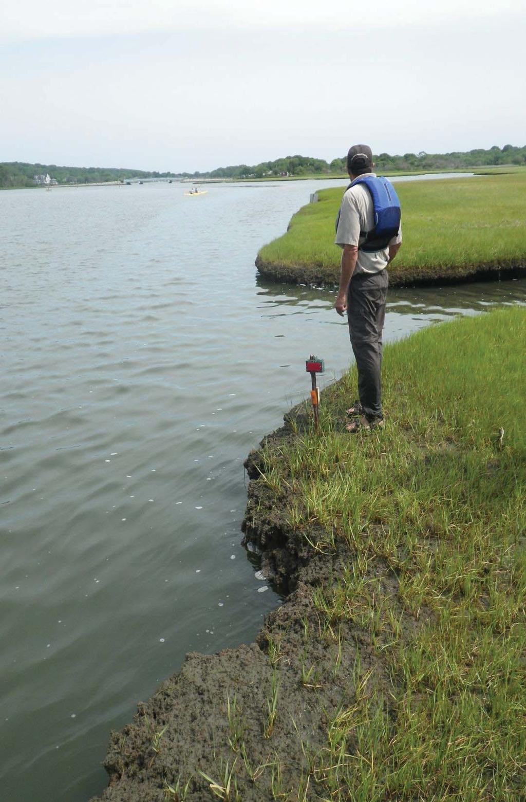
29 Brown, TNC


30 Rebar stake (marsh loss 0.2 ft./yr.), 2012 Rebar stake set 1-ft back from marsh edge, 2010 Brown, TNC
31 Narrow River Site Suitability Ruddock, TNC

32 Narrow River Site Suitability Suitable Fetch < 2 miles, Narrow River Ruddock, TNC Not Suitable Fetch < 2 miles, Narragansett Bay

33 Narrow River Site Suitability Ruddock, TNC Bathymetry Suitable: 2 feet MLW Slope Suitable:: 20%


34 Narrow River Site Suitability Habitat suitability, field surveys, and population monitoring shows promise Shellfish settlement 58.4 ind m -2 Upper Reach, ind m -2 Sedge Island, 2012 Shellfish reefs will improve fishery resources Shellfish reefs are sustainable Sediment burial is unlikely if wellengineered and vertically complex Shellfish reef complex, Bottom image of subtidal reef in lower pond, Oyster spat settlement collector,
 ranged from 5.47 to 11.62 cm - Tidal range is 7-12 inches, 7-in at middle bridge and 11-in at Sprague bridge - Factor in 12-in for tidal range 35")
35 Project Design Coir log and oyster sill, Narrow River Site Conditions - Slope must be less than 20% - Height of oyster sill must be equal to or greater than mean high water - Maximum wave height (H max ) ranged from 5.47 to cm - Tidal range is 7-12 inches, 7-in at middle bridge and 11-in at Sprague bridge - Factor in 12-in for tidal range 35
 waters is prohibited When structural shoreline protection is proposed, the")

36 Permits & Regulations Construction of new hardened structures in Type 1 (Conservation Areas) waters is prohibited When structural shoreline protection is proposed, the owner exhaust all reasonable and practical alternatives (Section E.1). Erosion Control Permits RI DEM Water Quality Permit RI CRMC Assent ACOE Category 1 fill Ruddock, TNC


; expected date of completion is May 2014")

37 Narrow River Evaluation Project Timeline Phase I establish baseline information on salt marsh and shellfish populations; permit application and coordination with partners; expected date of completion January 2014 Phase II site installation (restoration); expected date of completion is May 2014 Phase III post-restoration monitoring for two years; expected date of completion is January 2016 Identify Sites Installation Monitor results

38 Questions, Comments? Contact me for more information:
29 National Estuarine Research Reserves
 Estuarine habitat is where it's at! Living Shorelines for Erosion Control Whitney Jenkins North Carolina Coastal Reserve & National Estuarine Research Reserve Division of Coastal Management 29 National
Estuarine Shoreline Stabilization
 Estuarine Shoreline Stabilization Property Owner s Guide to Determining the Most Appropriate Stabilization Method Estuarine shorelines are dynamic features that experience continued erosion. Land is lost
Shoreline Studies Program, Department of Physical Sciences, VIMS
 Living Shoreline Training Class 2017 1 Demonstration sites discussed in this talk. 2 A shoreline management plan for the entire creek made conceptual shoreline management recommendations along every stretch
For more information or permission to reprint slides, please contact Donna Milligan at 1
 For more information or permission to reprint slides, please contact Donna Milligan at milligan@vims.edu 1 For more information or permission to reprint slides, please contact Donna Milligan at milligan@vims.edu
VIMS CCRM Coastal Management Decision Tools. Decision Tree for Undefended Shorelines and Those with Failed Structures
 VIMS CCRM Coastal Management Decision Tools Decision Tree for Undefended Shorelines and Those with Failed Structures Center for Coastal Resources Management Virginia Institute of Marine Science Gloucester
Design and Construction of Living
 Design and Construction of Living Shorelines A course for living shorelines professionals September 29, 2010 This course made possible by a grant from the Virginia Coastal Zone Management Program NOAA
ALTERNATIVES FOR COASTAL STORM DAMAGE MITIGATION
 ALTERNATIVES FOR COASTAL STORM DAMAGE MITIGATION Dave Basco Old Dominion University, Norfolk, Virginia, USA National Park Service Photo STRUCTURAL (changes to natural, physical system) hardening (seawalls,
Design Considerations for Living Shorelines in Connecticut. Jennifer E.D. O Donnell Department of Marine Sciences University of Connecticut
 Design Considerations for Living Shorelines in Connecticut Jennifer E.D. O Donnell Department of Marine Sciences University of Connecticut October 2015 1 Contents Contents... 2 1 Why Living Shorelines?...
Living Shorelines. Created by: JoAnn Moody & Tina Miller-Way Discovery Hall Programs Dauphin Island Sea Lab
 Living Shorelines Created by: JoAnn Moody & Tina Miller-Way Discovery Hall Programs Dauphin Island Sea Lab Living Shorelines Subject: Life Science Grade Level: 6 th -8 th Time Required: 60 min Key Terms:
ALTERNATIVES FOR COASTAL STORM DAMAGE MITIGATION AND FUNCTIONAL DESIGN OF COASTAL STRUCTURES
 The University of the West Indies Organization of American States PROFESSIONAL DEVELOPMENT PROGRAMME: COASTAL INFRASTRUCTURE DESIGN, CONSTRUCTION AND MAINTENANCE A COURSE IN COASTAL DEFENSE SYSTEMS I CHAPTER
AIRPORT RD. EROSION HOMEOWNER FOCUS GROUP SUMMARY 1/1/ PM NATURE COAST BIOLOGICAL STATION
 AIRPORT RD. EROSION HOMEOWNER FOCUS GROUP SUMMARY 1/1/2018 6 8 PM NATURE COAST BIOLOGICAL STATION This workshop was the fourth in a series of workshops about coastal erosion in Cedar Key hosted by the
GONE! Coastal Erosion Happens During Storms! Why Worry About Coastal Setbacks? Goals for Today
 RI Regulatory Setbacks & Buffers: Coastal Zone Management Issues New England Onsite Wastewater Training Program @ URI OWT 155 November 21, 2013 Goals for Today Understand the impacts of storms, coastal
Building Coastal Resiliency at Plymouth Long Beach
 Building Coastal Resiliency at Plymouth Long Beach Department of Marine and Environmental Affairs March 30, 2017 Introducing Green Infrastructure for Coastal Resiliency Plymouth Long Beach & Warren s Cove
The Dynamic Coast. Right Place Resources. A presentation about the interaction between the dynamic coast and people
 The Dynamic Coast Houses threatened by coastal erosion in California Right Place Resources A presentation about the interaction between the dynamic coast and people For the rest of the presentations in
STATUS REPORT FOR THE SUBMERGED REEF BALL TM ARTIFICIAL REEF SUBMERGED BREAKWATER BEACH STABILIZATION PROJECT FOR THE GRAND CAYMAN MARRIOTT HOTEL
 August 23 STATUS REPORT FOR THE SUBMERGED REEF BALL TM ARTIFICIAL REEF SUBMERGED BREAKWATER BEACH STABILIZATION PROJECT FOR THE GRAND CAYMAN MARRIOTT HOTEL performed by Lee E. Harris, Ph.D., P.E. Consulting
Coastal management has lagged behind the growth in population leading to problems with pollution
 Fifty percent of the population of the industrialized world lives within 100 km of a coast. Coastal management has lagged behind the growth in population leading to problems with pollution and natural
Energy Attenuation & Hybrid Living Shorelines: A Viable Tool for Coastal Resilience
 Energy & Hybrid Living Shorelines: A Viable Tool for Coastal Resilience Hot Topic Session Delaware Estuary Science & Environmental Summit Balancing Progress & Protection 10 Years of Science in Action January
RI Regulatory Setbacks & Buffers: Coastal Management Issues
 RI Regulatory Setbacks & Buffers: Coastal Management Issues New England Onsite Wastewater Training Program @ URI OWT 155 - November 29, 2012 James Boyd - Coastal Policy Analyst Photo: October 30, 2012
Conservation and Restoration Florida s Coastal Marshes: An Overview of MESS. Jeff Beal, Kent Smith, Erin McDevitt, Maria Merrill
 Conservation and Restoration Florida s Coastal Marshes: An Overview of MESS Jeff Beal, Kent Smith, Erin McDevitt, Maria Merrill FWC s MESS: -Marine/Estuarine Subsection -within Aquatic Habitat Conservation
SARASOTA BAY ESTUARY PROGRAM OYSTER HABITAT MONITORING RESULTS: YEAR 1. Jay R. Leverone
 SARASOTA BAY ESTUARY PROGRAM OYSTER HABITAT MONITORING RESULTS: YEAR 1 by Jay R. Leverone Mote Marine Laboratory 1600 Ken Thompson Parkway Sarasota, Fl 34236 to Gary Raulerson Sarasota Bay Estuary Program
LAB: WHERE S THE BEACH
 Name: LAB: WHERE S THE BEACH Introduction When you build a sandcastle on the beach, you don't expect it to last forever. You spread out your towel to sunbathe, but you know you can't stay in the same spot
Chronic coastal erosion is a statewide problem
 Chronic coastal erosion is a statewide problem 1 Seawalls are constructed where there is erosion, but they do not solve the erosion they often worsen it along adjacent shores. Hawaii needs erosion solutions.
Project Webpage:
 Project Webpage: http://nature.ly/marinesatlanticbightera Coastal Data and Full Metadata: http://easterndivision.s3.amazonaws.com/marine/sab MA/SABMACoastalEcosystems.zip Coastal Chapter: http://easterndivision.s3.amazonaws.com/marine/sab
Figure79. Location map for the 10 NJBPN profile sites in Atlantic County, NJ 155
 154 Figure79. Location map for the 10 NJBPN profile sites in Atlantic County, NJ 155 ATLANTIC COUNTY SPRING 2009 to FALL 2010 The Atlantic County coastline consists of three barrier islands. Between Little
Coastal Change and Conflict
 Coastal Change and Conflict Outline of the Topic Contrasting Coasts why do all coasts not look the same? Geology of the coast the impact rock structure has on the coastline Waves Constructive and destructive
Lessons Learned from Shoreline Protection Demonstration Projects in Southwest Louisiana
 Lessons Learned from Shoreline Protection Demonstration Projects in Southwest Louisiana Tommy McGinnis and Maggie Luent CPRA Operations Division Lafayette Regional Office State of the Coast June 01, 2018
Eric Sparks.
 Eric Sparks eric.sparks@msstate.edu AL.com AL.com NOAA Gulf Spill Restoration Ecological Consulting Services, Inc. Eric Sparks Shoreline begins to recede Bulkhead installed Vertical erosion occurs
Shoreline Erosion Control Failures and How To Avoid Them
 2008 Illinois Lake Management Association Shoreline Erosion Control Failures and How To Avoid Them by: Hank Sutton, President, Lake Rip Rap, Inc. www.lakeriprap.com - www.macoupinboats.com Setting the
Figure 1. Schematic illustration of the major environments on Mustang Island.
 STOP #1: PACKERY CHANNEL BEACH TO BAY We will start this field guide near the north jetty of Packery Channel and hike across the island to Corpus Christi Bay (fig. 1). The island emerges from the Gulf
Rhode Island Department of Environmental Management Division of Fish and Wildlife American Shad Habitat Plan for the Pawcatuck River
 Rhode Island Department of Environmental Management Division of Fish and Wildlife American Shad Habitat Plan for the Pawcatuck River Prepared by: Phil Edwards, Rhode Island Department of Environmental
OYSTER REEF RESTORATION; RESTORING ECOLOGICAL FUNCTION
 OYSTER REEF RESTORATION; RESTORING ECOLOGICAL FUNCTION Paul Jensen, David Buzan, and Ka-Leung Lee; Atkins Mark Dumesnil and Julie Sullivan; The Nature Conservancy Presentation Overview The Nature Conservancy
Habitat Development: Habitat Boulders Lawson Pier Foreshore Enhancement
 Habitat Development: Habitat Boulders Improve the existing habitat by stabilising beach sediments. Increase biodiversity by creating new habitats and colonisation opportunities. Loose cobble is unstable;
Living Shorelines: Considerations for Advancing Coastal Resiliency
 Living Shorelines: Considerations for Advancing Coastal Resiliency Elaine Mahoney 1, James Turek 2, Janine Harris 3, and Karen Greene 4 1 NOAA Coastal Services Center, NY 2 NOAA Restoration Center, Narragansett,
Overview. Beach Features. Coastal Regions. Other Beach Profile Features. CHAPTER 10 The Coast: Beaches and Shoreline Processes.
 Overview CHAPTER 10 The Coast: Beaches and Shoreline Processes Coastal regions constantly change. The beach is a dominant coastal feature. Wave activity continually modifies the beach and coastal areas.
Big Spring Creek Habitat Enhancement and Fishery Management Plans
 Big Spring Creek Habitat Enhancement and Fishery Management Plans November 5, 2012 Big Spring Events and Activities Center Newville, PA Charlie McGarrell Regional Habitat Biologist Pennsylvania Fish and
Restoration of Intertidal Oyster Reefs Affected by Boating Activity in Mosquito Lagoon, Florida
 Restoration of Intertidal Oyster Reefs Affected by Boating Activity in Mosquito Lagoon, Florida Andrea Barber, University of Central Florida Dr. Linda Walters, University of Central Florida Anne Birch,
Leaning Into Adaptation
 www.marinslr.org Leaning Into Adaptation GFNMS Ocean Summit, May 17, 2016 Jack Liebster, Planning Manager, Marin County Marin County C-SMART Sea Level Rise Adaptation Process Evaluate Science Info. Implement
Restoring the Kootenai: A Tribal Approach to Restoration of a Large River in Idaho
 Restoring the Kootenai: A Tribal Approach to Restoration of a Large River in Idaho Susan Ireland, Kootenai Tribe of Idaho Future of our Salmon Conference Technical Session August 2016 Healthy Floodplains,
COASTAL MANAGEMENT AND PROTECTION METHODS! 1
 COASTAL MANAGEMENT AND PROTECTION METHODS! 1 Strategy What it does Cons Pros Examples SOFT ENGINEERING: The use of ecological principles and practices to reduce erosion and achieve the stabilization and
MS/AL Living Shoreline Workshop
 Daniel Wachenfeld / Triggerfish Images MS/AL Living Shoreline Workshop 2010 Jeff DeQuattro jdequattro@tnc.org March 17, Living Shoreline Restoration Graphic Credit: Mobile Press Register Living Shoreline
ATLANTIC COUNTY 2006 to 2008
 ATLANTIC COUNTY 2006 to 2008 The Atlantic County oceanfront shoreline consists of three barrier islands where the northern one, Little Beach Island and a third of the second, Brigantine Island, are undeveloped
Tracy E. Skrabal. October 2, 2012
 Tracy E. Skrabal October 2, 2012 Jurisdiction Living Shorelines/Sills Timeline for Permit Bulkhead/Revetments North Atlantic Division New England Division suspended all nationwide permits March 20, 2012
Combating Erosion at Mosquito Point
 2010 Combating Erosion at Mosquito Point A Report Generated by the Students of EVST 305: Environmental Problem Solving Randolph-Macon College 3/11/2010 TECHNICAL REPORT RMC-EVST 2009-2 Introduction to
NORTHERN CELL OPTIONS SHORTLIST RECOMMENDATIONS
 OPTIONS SHORTLIST RECOMMENDATIONS Coastal Unit C: Bayview Options recommended for MCDA scoring. Status quo. Planting 3. Renourishment (gravel) 6. Beach-scraping 7. Restore shingle crest. Inundation accommodation
Puget Sound Nearshore Ecosystem Restoration Project Restore America s Estuaries Conference 2012 Tampa, FL
 Restore America s Estuaries Conference 2012 Tampa, FL presented by: Theresa Mitchell, WA Dept. of Fish & Wildlife Nearshore General Investigation Change Analysis: Comparison of historical and current
Deadman s Island Appreciation for past, present and future. Project Manager- Heather Reed Ecological Consulting Services Inc.
 Deadman s Island Appreciation for past, present and future Project Manager- Heather Reed Ecological Consulting Services Inc. Deadman s Island Rare Gem 1743 1698 1742 18 th Century Used by the Spanish and
Examples of estuaries include bays, sounds, salt marshes, mangrove forests, mud flats, swamps, inlets, and sloughs.
 An estuary is a partially enclosed body of water where incoming seawater is mixed with fresh water coming from the land. Examples of estuaries include bays, sounds, salt marshes, mangrove forests, mud
Puget Sound Shorelines. Waves and coastal processes. Puget Sound shorelines: Effects of beach armoring
 Puget Sound Shorelines Puget Sound shorelines: Effects of beach armoring Waves and coastal processes Factors affecting wave energy hitting the coast Processes transporting sediment along coastlines What
PLAQUEMINES PARISH BARRIER ISLAND RESTORATION & SUSTAINABILITY. MVD/Gulf Coast Regional Dredging Meeting November 5, 2013
 PLAQUEMINES PARISH BARRIER ISLAND RESTORATION & SUSTAINABILITY MVD/Gulf Coast Regional Dredging Meeting November 5, 2013 OVERVIEW 1. Barrier Island Restoration Projects in Plaquemines Parish 2. Plaquemines
Longshore Bar Creation: a viable option for seagrass restoration?
 Longshore Bar Creation: a viable option for seagrass restoration? Lindsay M. Cross, Tampa Bay Estuary Program Holly Greening, Tampa Bay Estuary Program Michael Seifert, Tampa Port Authority Susan Burtnett,
National Oceanic and Atmospheric Administration (NOAA)/ Mulberry Phosphate Trustee Council September 12, 2013
/ Mulberry Phosphate Trustee Council September 12, 2013") OYSTER REEF CREATION PROJECT DESIGN AND IMPLEMENTATION IN HILLSBOROUGH BAY, FLORIDA TAMPA BAY REGIONAL PLANNING COUNCIL AGENCY ON BAY MANAGEMENT MEETING National Oceanic and Atmospheric Administration
OYSTER REEF CREATION PROJECT DESIGN AND IMPLEMENTATION IN HILLSBOROUGH BAY, FLORIDA TAMPA BAY REGIONAL PLANNING COUNCIL AGENCY ON BAY MANAGEMENT MEETING National Oceanic and Atmospheric Administration
Essentials of Oceanography Eleventh Edition
 Chapter Chapter 1 10 Clickers Lecture Essentials of Oceanography Eleventh Edition The Coast: Beaches and Shoreline Processes Alan P. Trujillo Harold V. Thurman Chapter Overview Coastal regions have distinct
6/19/2006 The Reef Ball Foundation 1
 6/19/2006 The Reef Ball Foundation 1 Overview Reef Balls are prefabricated concrete modules used as a base for natural coral reefs to form. Reef Balls have been used in 55 countries in over 3,500 projects
Blakely Island, N Thatcher Bay. Restoration Recommendation: Rank Score (total score)
") Soft Shore Protection/Structure Removal Blueprint for San Juan County Forage Fish Beaches Appendix 2: Recommendations for sites scoring below the top ten, sorted by island (east to west) Blakely Island,
Soft Shore Protection/Structure Removal Blueprint for San Juan County Forage Fish Beaches Appendix 2: Recommendations for sites scoring below the top ten, sorted by island (east to west) Blakely Island,
Marsh Vegetation and Substrate Interactions with Wind-wave Energy in San Francisco Bay:
 Whole Marsh Restoration: Wind Wave Energy Management in Context II (Baye) March 18, 2008 Wind-wave and Tidal Marsh Restoration Workshop BCDC, San Francisco Marsh Vegetation and Substrate Interactions with
Nearshore Sediment Transport What influences the loss of sediment on Beaches? - Waves - Winds - Tidal Currents - River discharge - Runoff
 Tides & Beaches Nearshore Sediment Transport What influences the loss of sediment on Beaches? - Waves - Winds - Tidal Currents - River discharge - Runoff Oceans Ocean Topography Physical Structure of the
CHAPTER 4 - SHORELINE PROTECTION STUDY AND PLAN
 CHAPTER 4 Shoreline Protection Study and Plan 4-1 CHAPTER 4 - SHORELINE PROTECTION STUDY AND PLAN I. SHORELINE PROTECTION STUDY Lancaster County is a coastal community that has, as previously stated, approximately
OYSTER REEFS 101: AN ENGINEERS PERSPECTIVE
 OYSTER REEFS 101: AN ENGINEERS PERSPECTIVE Restore America s Estuaries, Tampa FL October 2012 Dr. Jon D. Risinger, Ph.D. Lead Coastal Engineer MWH Global, Inc. THE EASTERN OYSTER CRASSOSTREA VIRGINICA
Atlantic Coast of Long Island, Jones Inlet to East Rockaway Inlet, Long Beach Island, NY Construction Update
 Atlantic Coast of Long Island, Jones Inlet to East Rockaway Inlet, Long Beach Island, NY Construction Update June 2016 US Army Corps of Engineers Project Purpose Three specific damage mechanisms of coastal
OECS Regional Engineering Workshop September 29 October 3, 2014
 B E A C H E S. M A R I N A S. D E S I G N. C O N S T R U C T I O N. OECS Regional Engineering Workshop September 29 October 3, 2014 Coastal Erosion and Sea Defense: Introduction to Coastal Dynamics David
NCCOE EA Coastal Adaptation Guidelines. Section I Emerging Technology Novel Alternative Approaches to Coastal Erosion
 NCCOE EA Coastal Adaptation Guidelines Section I Emerging Technology Novel Alternative Approaches to Coastal Erosion Alessio Mariani, Doug Lord, Tony Webb James Carley, Matt Blacka, Brett Miller Ian Turner,
Earth Science Chapter 16 Section 3 Review
 Name: Class: Date: Earth Science Chapter 16 Section 3 Review Multiple Choice Identify the choice that best completes the statement or answers the question. 1. The movement of water that parallels the shore
The Sand Beaches of New Hampshire and Maine
 The Sand Beaches of New Hampshire and Maine Beach Preservation and Erosion Control Photographs provided by Joe Kelly and Steve Adams Cover photo: Reid State Park, ME Introduction The sand beaches of New
Nearshore Waves and Erosion Model Quantifying the Coastal Protection Benefits Provided by Natural Habitats
 Nearshore Waves and Erosion Model Quantifying the Coastal Protection Benefits Provided by Natural Habitats SaveGuanaCayReef Marinehindsight.com Necessary to quantify protection services offered by natural
RE: Hurricane Matthew Beach Damage Assessment and Recommendations [CSE 2416]
![RE: Hurricane Matthew Beach Damage Assessment and Recommendations [CSE 2416]](/thumbs/83/87675702.jpg "RE: Hurricane Matthew Beach Damage Assessment and Recommendations [CSE 2416]") October 25, 2016 Iris Hill Town Administrator Town of Edisto Beach 2414 Murray St Edisto Beach SC 29438 RE: Hurricane Matthew Beach Damage Assessment and Recommendations [CSE 2416] Dear Iris, Hurricane
October 25, 2016 Iris Hill Town Administrator Town of Edisto Beach 2414 Murray St Edisto Beach SC 29438 RE: Hurricane Matthew Beach Damage Assessment and Recommendations [CSE 2416] Dear Iris, Hurricane
Coastal Hazards and Management in North Carolina. Braxton Davis April 14, 2015
 Coastal Hazards and Management in North Carolina Braxton Davis April 14, 2015 Coastal Facts and Figures 320 miles of ocean beaches 12,000+ miles of estuarine shoreline 2 million + acres of sounds, creeks,
Species Conclusions Table
 Conclusions Table Project Name: Chesapeake Landing HOA- Breakwaters (NAO-14-0283) Date: February 25, 2014 /Resource Name Loggerhead sea turtle (Caretta caretta) Conclusion ESA Section 7 / Eagle Act Determination
U.S. Fish and Wildlife Service Native American Crosscut Funding
 U.S. Fish and Wildlife Service Native American Crosscut Funding Tribal / Interior Budget Council National Budget Meeting L Enfant Plaza Hotel Washington, DC November 8, 2013 U.S. Fish and Wildlife Service
Welcome to Paddle for the Edge!
 Welcome to Paddle for the Edge! Thank you for volunteering to conduct a survey of the Barnegat Bay s shorelines. As a citizen scientist, you become part of a project to collect critical data about current
Friends of the Detroit River Habitat Restoration Project Update
 Friends of the Detroit River Habitat Restoration Project Update 11 Beneficial Use Impairments (BUIs) were originally identified to be associated with the Detroit River: 1. Restrictions on fish and wildlife
July 14, The Beaches Conference Greg Berman (WHOI Sea Grant & Cape Cod Cooperative Extension)
") July 14, 2017 The Beaches Conference 2017 Greg Berman (WHOI Sea Grant & Cape Cod Cooperative Extension) Annual downscaled global tropical cyclones, averaged over the six models. Uses data from IPCC Fifth
July 14, 2017 The Beaches Conference 2017 Greg Berman (WHOI Sea Grant & Cape Cod Cooperative Extension) Annual downscaled global tropical cyclones, averaged over the six models. Uses data from IPCC Fifth
Subtidal and intertidal restored reefs in North Carolina
 Subtidal and intertidal restored reefs in North Carolina Jonathan H. Grabowski 1, Sean P. Powers 2, Pete Peterson 3, and Hunter S. Lenihan 4 1 Gulf of Maine Research Institute/U. Maine-Darling Marine Center
How many adult oysters are in the Great Bay Estuary and how has it changed over time?
 Indicator: in the Great Bay Estuary Question How many adult oysters are in the Great Bay Estuary and how has it changed over time? Short Answer The number of adult oysters decreased from over 25 million
Weighing Your Options. How to Protect Your Property from Shoreline Erosion: A handbook for estuarine property owners in North Carolina
 Weighing Your Options How to Protect Your Property from Shoreline Erosion: A handbook for estuarine property owners in North Carolina Original version of this guide was written by Seachange Consulting
Response of a Newly Created Marsh-Wetland Affected by Tidal Forcing, Upland Discharge, and Groundwater Interaction
 Response of a Newly Created Marsh-Wetland Affected by Tidal Forcing, Upland Discharge, and Groundwater Interaction Mouth of Columbia River, Cape Disappointment State Park, Washington 12 Hans R. Moritz
Anguilla. Wise practices for coping with. i b bea n Se a
 Wise practices for coping with Anguilla Car i b bea n Se a Department of Fisheries and Marine Resources, Anguilla Department of Physical Planning, Anguilla University of Puerto Rico, Sea Grant College
ALTERNATIVE SHORELINE TREATMENT GUIDELINE
 ALTERNATIVE SHORELINE TREATMENT GUIDELINE Prepared By: Galveston Bay Foundation 17324-A Highway 3 Webster, TX 77598 281-332-3381 www.galvbay.org May 9, 2003 17324-A Highway 3, Webster, TX 77598 Phone 281-332-3381
Today: Coastal Issues and Estuaries
 Today: Coastal Issues and Estuaries Coastal issues Human effect on coastlines What is an estuary Why are they so important? Circulation of water in estuary Environmental issues Coastal Issues: Problem
Shoreline Development
 Shoreline Development Erosion Control The evolution of the Chesapeake Bay shoreline has been influenced by residential and commercial development along the tidal shoreline. Commercial shoreline development
USE OF SEGMENTED OFFSHORE BREAKWATERS FOR BEACH EROSION CONTROL
 .. CETN-III-22 4/84 PURPOSE: USE OF SEGMENTED OFFSHORE BREAKWATERS FOR BEACH EROSION CONTROL To provide information on the functional application of and general design considerations for using offshore
NATIVE OYSTER RESTORATION AT ELKHORN SLOUGH, CALIFORNIA Summary of Elkhorn Slough National Estuarine Research Reserve and Elkhorn Slough Foundation
 NATIVE OYSTER RESTORATION AT ELKHORN SLOUGH, CALIFORNIA Summary of Elkhorn Slough National Estuarine Research Reserve and Elkhorn Slough Foundation partnership project Pain%ng by Cory and Catska Ench,
LOCAL COASTAL PROGRAM UPDATE
 LOCAL COASTAL PROGRAM UPDATE Agenda Meeting #1 General Information (1 1:45 pm) Introductions and Background Grants involved What is a Local Coastal Program? What is required? LCP Update tasks and schedule
SHORE PROTECTION AND HABITAT CREATION AT SHAMROCK ISLAND, TEXAS ABSTRACT
 SHORE PROTECTION AND HABITAT CREATION AT SHAMROCK ISLAND, TEXAS M. Cameron Perry, P.E., and Daniel J. Heilman, P.E. Coastal Engineer Shiner Moseley & Associates., Inc. 555 N. Carancahua Corpus Christi,
The Blue Heron Slough Conservation Bank
 1 The Blue Heron Slough Conservation Bank CONSERVATION BANKING July 19-23, 2010 CASE STUDY SERIES The Blue Heron Slough Conservation Bank (Washington) I. OVERVIEW & BACKGROUND: Location: Snohomish River
EVALUATING THE EFFECTS OF BIVALVE SHELLFISH AQUACULTURE AND ITS ECOLOGICAL ROLE IN THE ESTUARINE ENVIRONMENT IN THE UNITED STATES
 EVALUATING THE EFFECTS OF BIVALVE SHELLFISH AQUACULTURE AND ITS ECOLOGICAL ROLE IN THE ESTUARINE ENVIRONMENT IN THE UNITED STATES Brett Dumbauld USDA Agricultural Research Service, Hatfield Marine Science
Nevis. Wise practices for coping with
 Wise practices for coping with Nevis Caribbean Sea Nevis Historical and Conservation Society Department of Physical Planning, Natural Resources and Environment, Fisheries Division University of Puerto
St Kitts. Wise practices for coping with
 Wise practices for coping with St Kitts Caribbean Sea Department of the Environment, St Kitts Fisheries Division, St Kitts Physical Planning and Development Division, St Kitts University of Puerto Rico,
FACT SHEET MCGREGOR LAKE RESTORATION HABITAT PROJECT POOL 10, UPPER MISSISSIPPI RIVER, WISCONSIN ENVIRONMENTAL MANAGEMENT PROGRAM
 FACT SHEET MCGREGOR LAKE RESTORATION HABITAT PROJECT POOL 10, UPPER MISSISSIPPI RIVER, WISCONSIN ENVIRONMENTAL MANAGEMENT PROGRAM LOCATION McGregor Lake is located within a mid-river island in Pool 10
FACT SHEET I. LOCATION
 STEAMBOAT ISLAND HABITAT REHABILITATION AND ENHANCEMENT PROJECT (HREP) SCOTT COUNTY, IOWA, UPPER MISSISSIPPI RIVER RESTORATION-ENVIRONMENTAL MANAGEMENT PROGRAM ROCK ISLAND DISTRICT FACT SHEET I. LOCATION
County of Santa Barbara Permit Option Analysis Goleta Beach JULY 13, 2017
 County of Santa Barbara Permit Option Analysis Goleta Beach JULY 13, 2017 Introduction 2 Goleta Beach Park welcomes 1.5 million visitors annually Amenities include: Picnic Areas and Group Areas w/bbqs
SOCIETAL GOALS TO DETERMINE ECOSYSTEM HEALTH: A FISHERIES CASE STUDY IN GALVESTON BAY SYSTEM, TEXAS
 SOCIETAL GOALS TO DETERMINE ECOSYSTEM HEALTH: A FISHERIES CASE STUDY IN GALVESTON BAY SYSTEM, TEXAS Anthony S. Pait, NOAA, National Centers for Coastal Ocean Science Thomas P. O Connor, David R. Whitall,
Montserrat. Wise practices for coping with. i b bea n Se a
 Wise practices for coping with Montserrat Car i b bea n Se a Fisheries Division, Montserrat Physical Planning Department, Montserrat University of Puerto Rico, Sea Grant College Program Caribbean Development
NORTHAMPTON COUNTY WETLANDS BOARD Minutes May 15, 2013
 NORTHAMPTON COUNTY WETLANDS BOARD Minutes May 15, 2013 This was the regular meeting of the Northampton County Wetlands Board held on Wednesday, May 15, 2013 in the Board Chambers located at 16404 Courthouse
Greg Berman (WHOI Sea Grant & Cape Cod Cooperative Extension) November 2, 2017
 November 2, 2017") November 2, 2017 Are You Ready for the Next Big Storm?: A Workshop for Hardy Cape Codders Greg Berman (WHOI Sea Grant & Cape Cod Cooperative Extension) Outline: ~30 min talk & time for questions Practical
November 2, 2017 Are You Ready for the Next Big Storm?: A Workshop for Hardy Cape Codders Greg Berman (WHOI Sea Grant & Cape Cod Cooperative Extension) Outline: ~30 min talk & time for questions Practical
OYSTER RESTORATION IN EUROPE & USA: REALISING MULTIPLE BENEFITS. Morven Robertson
 OYSTER RESTORATION IN EUROPE & USA: REALISING MULTIPLE BENEFITS Morven Robertson OYSTERS ECOSYSTEM SERVICES Oysters provide a suite of ecosystem services Biodiversity hotspots Water quality Denitrification
Estuary Care Foundation SA: community led restoration & climate adaptation
 Estuary Care Foundation SA: community led restoration & climate adaptation Presentation to SA Coastal Conference 9 th November 2017 Catherine McMahon, Estuary Care Foundation Port River and Barker Inlet
SPECIAL SPRING 2018 STORM REPORT ON THE CONDITION OF THE MUNICIPAL BEACHES FOR THE BOROUGH OF STONE HARBOR, CAPE MAY COUNTY, NEW JERSEY
 SPECIAL SPRING 2018 STORM REPORT ON THE CONDITION OF THE MUNICIPAL BEACHES FOR THE BOROUGH OF STONE HARBOR, CAPE MAY COUNTY, NEW JERSEY Aerial photograph taken April 21, 2018 showing the view up the beach
Cat Island Chain Restoration
 Cat Island Chain Restoration 1820s Fox River Military Road Map to Fort Howard 1845 Chart of Green Bay & Fox River Cat Island Chain - 1938 Cat Island Brown County Aerial Photography, 1938 Historic Western
Restoration of Eelgrass to Upper Casco Bay: Feasibility Tests in Hilary A. Neckles US Geological Survey Augusta, ME
 Restoration of Eelgrass to Upper Casco Bay: Feasibility Tests in 2015 Hilary A. Neckles US Geological Survey Augusta, ME hneckles@usgs.gov Robert J. Orth Eelgrass: Zostera marina * marine flowering plant
X.B WETLANDS ROGUE RIVER ESTUARY
 X.B WETLANDS ROGUE RIVER ESTUARY The Rogue River has a drainage area of 5,100 square miles, yet the estuary of the Rogue River is one of the smallest in Oregon, measuring approximately 1,880 acres during