Gly 558. Introduction to Coastal Management. Aeolian Processes and Dunes. Namib Coastal Desert. What Can Dunes Tell Us About the Coastal System?
|
|
|
- Denis Gilbert
- 6 years ago
- Views:
Transcription


")
")


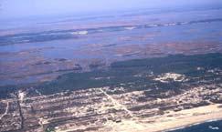
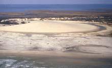
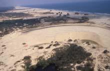
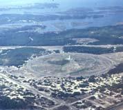
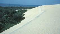
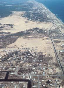
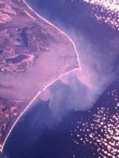
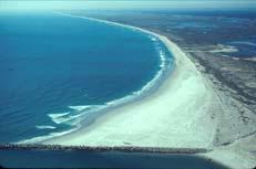
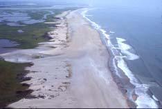
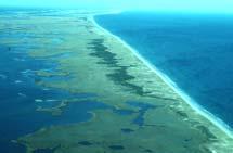
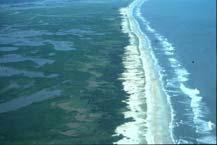
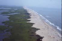
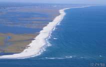
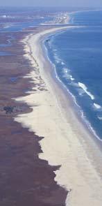
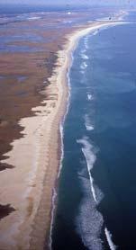
1 Gly 558 Introduction to Coastal Management 300m high Namib Coastal Desert GE Crescent dunes Onshore prevailing wind Benguella Current Aeolian Processes and Dunes Linear dunes Fog What Can Dunes Tell Us About the Coastal System? Their presence can provides clues about: Wind direction Sand supply, Storm history (scarps & washovers) Erosion history Sea level change Shoreline stability (with vegetation) Relative age Presence of inlets Man s influence Dune Types and Morphology Along NC coast there are two major types of dunes and several variations. Transverse Parabolic Medanos Sand sheets Slipface Transverse Dunes Parabolic dunes Dune Types and Morphology Parabolic Recurved Dunes and Spit Growth Recurved dune ridge complexes typically develop on the updrift side of migrating inlets. Sand Sheet Caswell Beach,NC Caswell Beach,NC Parabolics Parabolics Parabolics New Topsail Inlet Rich Inlet


.")

.")


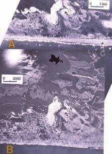
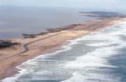
2 SC Spits and Recurved Dune Lines Large sand supply at migrating inlets leads to development of a variety of recurved dune complexes. Kiawah Island, SC Kiawah Island Modified Dune Ridges Vegetation has been stripped on some dune ridges (on regressive barriers). Results in remobilization of sand. Vegetation changes due to fires, hurricanes, man s activities (timber for boats & grazing). Remobilization of sand leads to different dune morphology (plan view and height). A Cape Romain B C Complex Parabolics Ilha de Florianópolis SC Moçambique Santinho Ingleses Migrating and arrested parabolics Praia Ingleses, SC, Brazil, SC, Brazil Outer Banks of North Carolina Currituck Banks Bodie Island Oregon Inlet Pea Island Cape Hatteras Hatteras Inlet Ocracoke Inlet Hatteras Island Drum Inlet Portsmouth Island Cape Core Banks Lookout 2


3 Outer Banks, NC (Currituck Spit) Flood Tidal Delta (FTD) Currituck Inlet Parabolics Parabolics/Medanos FTD FTD FTD Parabolic Dune Migration Kitty Hawk Jockey s Ridge Nags Head Area Roanoke Channel Sisters Dunes Wright Brothers Monument Feb 1984 Hatteras Lighthouse / Buxton Area Hatteras Island Buxton Hatteras Island 3


")


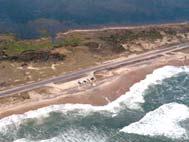
4 Mid 1930s Ocracoke Island Ocracoke Island / Mid 1990s Mid 1960s 1984 Core Banks Core Banks - Cape Lookout, NC New Drum Inlet 1978 Hurricane Gloria (1985) Breaches and Washovers Shackleford Banks Bogue Banks NC - Former Regressive Barrier Bogue Banks is comprised of several regressive barrier segments. Numerous areas of recurved beach/dune ridges testify to presence of former inlets. 4


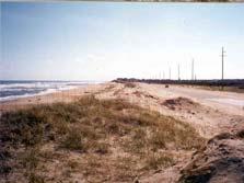
5 Forested Dune Ridges Maritime forest colonized sequence of high dune ridges Sand Rich Barriers Emerald Isle, NC (Bogue( Banks) Bogue Banks (East View 1975) Browns & Bear Islands Sand Rich Modified Dune/Beach Ridge Barriers Bogue Inlet Inlet Influence and Hurricane Response Hurricane Fran 9/7/96 Onslow Beach Impact of USMC amphibious exercises Loss of dune integrity Overwash & erosion Post Hurricane Fran Oct 1996 AIWW Hurricane Bonnie 8/28/98 5


6 New River Headland Area North Topsail Beach New River AIWW Onslow Beach Browns Inlet Bear Inlet Browns Island Bear Island Sand Rich Barriers New River Inlet N North Topsail Beach Sand Poor Barriers 0 3 KM North Topsail Beach Hurricane Fran (Sept. 5, 96) Topsail Island North Topsail Beach & Surf City 6


7 Topsail Beach Surf City, March 10th, 2001 Headland Pleistocene Barrier System Flood delta Refurbished dune Topsail Beach Chronic Erosion New Topsail Inlet, NC Net Drift 9/99 1/86 9/99 1/86 12/00 1/86 1/87 Lea & Hutaff Islands SE North Carolina North Topsail Beach Sand-Rich Barriers I Cape Lookout Submarine Headland Figure Eight Island N II Wilmington) Wrightsville Beach 15 km Kure Beach Cape Fear Sand-Poor Barriers 12/75 1/86 ONSLOW BAY Subeaerial Headland 8/99 8/00 7


")


8 Figure Eight Island North End Figure 8 Island 5/20/84 F8I North End Erosion (8/02) Figure Eight Is. Storm Related Damage A Post Hurricane Floyd (9/19/99) Shell Island Wrightsville Beach Figure Eight Island C Shell Island Resort 1986 Oct 98 12/75 8

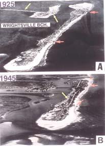
9 Wrightsville Beach Old Moore s Inlet /98 Masonboro Island Mid Barrier Change 9/80 8/98 Scarped 1980 Grasslands / /1998 Masonboro Island 1/87 1/98 10/98 Atlantic Intracoastal Waterway Lagoon (estuary) Termination Carolina Beach Masonboro Island Carolina Beach Inlet Rip-rap ~ 18 M yd 3 Beach Fill Former Tidal Creek (ca 1900) 9


")


10 Carolina Beach South View Kure Beach (Post-Hurricane Fran 9/96) Humate SS (Pleistocene) 3/1995 Pleistocene Stump Forest Rip-Rap Cape Fear River Cape Fear (Bald Head Island) Seawall Coquina Outcrop Mainland Riggins Townhouses Kure Beach Beachfill Project Cape Fear Foreland Fort Fisher Shoreline Change Jan 1998 Bald Head Island Oak Island Setting Pleistocene Sandstone /Coquina Long Beach Spit Yaupon Beach Headland Caswell Beach Spit 10


11 Eastern Spit (Caswell Beach) Cape Fear River Western Spit Oak Island (Long Beach) Caswell Spit Yaupon Beach Pleistocene Headland CPL Nuclear Plant Cooling Canal Caswell Spit Cape Fear River Hurricane Floyd (9/99) Beach Nourishment Holden Beach Inlet-Related Erosion 1994 Parabloic Dunes Erosion ranged from m since Holden Beach Erosion 1996 Eroded or Relocated 11
12 Ocean Isle Shallotte Inlet AIWW Oak Island Holden Beach Ebb Channel 19th C shoreline? 150 m erosion Ocean Isle 1996 Cleary 5/01 Ocean Isle & Sunset Beach Sunset Beach Sunset Beach Progradation Little River Inlet (SC/NC) Sunset Bch. Bird Is. Tubbs Inlet Mad Inlet Little River Inlet 1999 Little River Inlet Jetties Waites Is. Mad Inlet Sunset Bch

13 Little River Jetties - Bird Island 1996 Bird Is. Jetty 13
CRC Inlet Management Study. Matt Slagel Shoreline Management Specialist
 CRC Inlet Management Study Matt Slagel Shoreline Management Specialist Study Origin CRC shall study feasibility of creating new AEC for lands adjacent to mouth of Cape Fear River (HB 819) Collaborate with
Barrier Progradation Related to Inlet Spacing and Migration Patterns L.E. Budde and W.J. Cleary
 Journal of Coastal Research SI 39 117-121 ICS 2004 (Proceedings) Brazil ISSN 0749-0208 Barrier Progradation Related to Inlet Spacing and Migration Patterns L.E. Budde and W.J. Cleary MS Candidate, Center
Building Beaches with Navigation Sand, Just Don t Forget the Dunes!!
 Building Beaches with Navigation Sand, Just Don t Forget the Dunes!! Ken Willson Kenneth.Willson@CBI.com Introduction Decrease in Federal Funding (Shallow Draft Navigation Maintenance and Shore Protection)
CORPS ON THE COAST. North Carolina Coastal Conference Coastal Infrastructure Raleigh, NC April 14, Jim Medlock Chief, Programs Management Branch
 CORPS ON THE COAST North Carolina Coastal Conference Coastal Infrastructure Raleigh, NC April 14, 2015 Jim Medlock Chief, Programs Management Branch US Army Corps of Engineers OVERVIEW What Are The Corps
The purpose and needs of the Figure Eight Island Inlet and Shoreline Management Project are as follows:
 Chapter 2 PURPOSE AND NEEDS 1. What are the purpose and needs of this project? The main concern of residents and owners at Figure Eight Island are economic losses resulting from damages to structures and
Beach Nourishment, Static Lines, and Static Line Exceptions
 Beach Nourishment, Static Lines, and Static Line Exceptions Matt Slagel, Shoreline Management Specialist Coastal Resources Commission February 26, 2014 Nags Head Defining the Static Line Defining the Static
Coastal Hazards and Management in North Carolina. Braxton Davis April 14, 2015
 Coastal Hazards and Management in North Carolina Braxton Davis April 14, 2015 Coastal Facts and Figures 320 miles of ocean beaches 12,000+ miles of estuarine shoreline 2 million + acres of sounds, creeks,
RECREATIONAL WATERS - SAMPLING STATIONS N2. ATLANTIC OCEAN - COROLLA, BEACH ACCESS ACROSS FROM CURRITUCK LIGHTHOUSE.
 RECREATIONAL WATERS - SAMPLING STATIONS NORTHERN AREA N1. ATLANTIC OCEAN - COROLLA, END OF PAVED ROAD, BEACH ACCESS RAMP. N2. ATLANTIC OCEAN - COROLLA, BEACH ACCESS ACROSS FROM CURRITUCK LIGHTHOUSE. N3.
NC BEACH AND INLET MANAGEMENT PLAN FINAL REPORT
 VIII. Region 1 Region 1 encompasses Brunswick County from the North Carolina/South Carolina Border to the Brunswick County/New Hanover County line. The Towns of Sunset Beach, Ocean Isle Beach, Holden Beach,
Coastal management has lagged behind the growth in population leading to problems with pollution
 Fifty percent of the population of the industrialized world lives within 100 km of a coast. Coastal management has lagged behind the growth in population leading to problems with pollution and natural
New Jersey Coastal Zone Overview. The New Jersey Beach Profile Network (NJBPN) 3 Dimensional Assessments. Quantifying Shoreline Migration
 3 Dimensional Assessments. Quantifying Shoreline Migration") New Jersey Coastal Zone Overview The New Jersey Beach Profile Network (NJBPN) Objectives Profile Locations Data Collection Analyzing NJBPN Data Examples 3 Dimensional Assessments Methodology Examples Quantifying
New Jersey Coastal Zone Overview The New Jersey Beach Profile Network (NJBPN) Objectives Profile Locations Data Collection Analyzing NJBPN Data Examples 3 Dimensional Assessments Methodology Examples Quantifying
Overview. Beach Features. Coastal Regions. Other Beach Profile Features. CHAPTER 10 The Coast: Beaches and Shoreline Processes.
 Overview CHAPTER 10 The Coast: Beaches and Shoreline Processes Coastal regions constantly change. The beach is a dominant coastal feature. Wave activity continually modifies the beach and coastal areas.
BEACH PROCESSES AND COASTAL ENVIRONMENTS
 BEACH PROCESSES AND COASTAL ENVIRONMENTS COASTAL FEATURES Cross section Map view TOPICS: Terminology Waves Beach Morphology Barriers Coastal Migration Tides Tidal Flats and Marshes Sediment Budgets Human
Requirements: You will need to bring your laptop with Google Earth and Jtides loaded and ready to go. See Appendix
 Morphological Classification of Shorelines based on Hydrographic Regime Dr. Lindley Hanson, Dept. Geological Sciences Salem State College (lhanson@salemstate.edu) Key Concepts: hydrographic regime, morphological
Chapter 12: Coasts (after a brief review of Tides)
") Chapter 12: Coasts (after a brief review of Tides) 1 Questions from previous classes: What happens when a wave meets a current? wave = people walking current = bus If wave goes with the current, the wave
Chapter 12: Coasts (after a brief review of Tides) 1 Questions from previous classes: What happens when a wave meets a current? wave = people walking current = bus If wave goes with the current, the wave
US Beach Nourishment Experience:
 Beach Nourishment: Introduction of new sand to the beach by truck or dredge Large beach >1 million cubic yards (100,000 dump truck loads) Funding is a combination of federal, state, local & private Also
Reading Material. Inshore oceanography, Anikouchine and Sternberg The World Ocean, Prentice-Hall
 Reading Material Inshore oceanography, Anikouchine and Sternberg The World Ocean, Prentice-Hall BEACH PROCESSES AND COASTAL ENVIRONMENTS COASTAL FEATURES Cross section Map view Terminology for Coastal
GenCade Application at Onslow Bay, North Carolina
 GenCade Application at Onslow Bay, North Carolina by Ashley E. Frey, Sophie Munger, Greg L. Williams, Michael J. Wutkowski, and Kevin B. Conner PURPOSE: This Coastal and Hydraulics Engineering Technical
Coastal Harbors and Waterways, NC (Shallow Draft Navigation) (O&M)
 (O&M)") Coastal Harbors and Waterways, NC (Shallow Draft Navigation) (O&M) Shallow draft coastal harbors include a subsistence harbor at Silver Lake CONGRESSIONAL DISTRICT: NC 3, 7 DATE: 23 April 2018 1. AUTHORIZATION:
Coastal Harbors and Waterways, NC (Shallow Draft Navigation) (O&M) Shallow draft coastal harbors include a subsistence harbor at Silver Lake CONGRESSIONAL DISTRICT: NC 3, 7 DATE: 23 April 2018 1. AUTHORIZATION:
Coastal Harbors and Waterways, NC (Shallow Draft Navigation) (O&M)
 (O&M)") Coastal Harbors and Waterways, NC (Shallow Draft Navigation) (O&M) Shallow draft coastal harbors include a subsistence harbor at Silver Lake CONGRESSIONAL DISTRICT: NC 3 and 7 DATE: 23 February 2015 1.
Coastal Harbors and Waterways, NC (Shallow Draft Navigation) (O&M) Shallow draft coastal harbors include a subsistence harbor at Silver Lake CONGRESSIONAL DISTRICT: NC 3 and 7 DATE: 23 February 2015 1.
Volume and Shoreline Changes along Pinellas County Beaches during Tropical Storm Debby
 Volume and Shoreline Changes along Pinellas County Beaches during Tropical Storm Debby Ping Wang and Tiffany M. Roberts Coastal Research Laboratory University of South Florida July 24, 2012 Introduction
Chapter 20 Lecture. Earth: An Introduction to Physical Geology. Eleventh Edition. Shorelines. Tarbuck and Lutgens Pearson Education, Inc.
 Chapter 20 Lecture Earth: An Introduction to Physical Geology Eleventh Edition Shorelines Tarbuck and Lutgens The Shoreline: A Dynamic Interface The Coastal Zone The shoreline is constantly modified by
EVALUATION OF BEACH EROSION UP-DRIFT OF TIDAL INLETS IN SOUTHWEST AND CENTRAL FLORIDA, USA. Mohamed A. Dabees 1 and Brett D.
 EVALUATION OF BEACH EROSION UP-DRIFT OF TIDAL INLETS IN SOUTHWEST AND CENTRAL FLORIDA, USA Mohamed A. Dabees 1 and Brett D. Moore 1 The paper discusses the analysis of up-drift beach erosion near selected
Map 1 North Carolina s Regions. Using Photographs and Illustrations
 Section 1 The Tidewater Region Introduce Outline A. Barrier Islands B. The Sounds C. Swamps and Lakes Materials Textbook, pages 6-11 Blackline Masters The Tidewater: A Legacy of Lighthouses, page 4 Spanish
There are many different kinds of beaches which are generally characterized by the dominance of waves, tides, rivers and currents, and in particular
 Fig. 11-11, p. 253 There are many different kinds of beaches which are generally characterized by the dominance of waves, tides, rivers and currents, and in particular differ by the amount of energy, which
KEYNOTE PRESENTATION FSBPA olsen
 AMELIA ISAND, FLORIDA BEACH MANAGEMENT PARTNERING AND PERSERVERENCE Erik Olsen, PE associates, inc. KEYNOTE PRESENTATION FSBPA 2009 IN ORDER TO ADDRESS SHORE PROTECTION TODAY LOCAL INTERESTS PARTNER WITH:
Essentials of Oceanography Eleventh Edition
 Chapter Chapter 1 10 Clickers Lecture Essentials of Oceanography Eleventh Edition The Coast: Beaches and Shoreline Processes Alan P. Trujillo Harold V. Thurman Chapter Overview Coastal regions have distinct
DUNE STABILIZATION AND BEACH EROSION
 DUNE STABILIZATION AND BEACH EROSION CAPE HATTERAS NATIONAL SEASHORE NORTH CAROLINA ROBERT DOLAN PAUL GODFREY U. S. DEPARTMENT OF INTERIOR NATIONAL PARK SERVICE OFFICE OF NATURAL SCIENCE WASHINGTON, D.
Under the Boardwalk: Coastal Geomorphology
 Under the Boardwalk: Coastal Geomorphology What to look for while you're on the beach during spring break. What Causes Changes in Sea Level? Answer Varies with Time Scale. Long-Term Changes in Sea Level
Controlling Coastal erosion
 Controlling Coastal erosion Coastal Erosion Rates in the U.S. Coastal Erosion and Stabilization Economic pressures demanding the stabilization of beaches and coastlines are immense Coastal Erosion and
Identification of and Remedial Approaches to Hot Spots
 Identification of and Remedial Approaches to Hot Spots by Donald K. Stauble and Mark B. Gravens PURPOSE: This Coastal and Hydraulics Engineering Technical Note (CHETN) provides information about the suspected
Earth Science Chapter 16 Section 3 Review
 Name: Class: Date: Earth Science Chapter 16 Section 3 Review Multiple Choice Identify the choice that best completes the statement or answers the question. 1. The movement of water that parallels the shore
Beach profile surveys and morphological change, Otago Harbour entrance to Karitane May 2014 to June 2015
 Beach profile surveys and morphological change, Otago Harbour entrance to Karitane May 2014 to June 2015 Prepared for Port Otago Ltd Martin Single September 2015 Shore Processes and Management Ltd Contact
Chapter 10 Lecture Outline. The Restless Oceans
 Chapter 10 Lecture Outline The Restless Oceans Focus Question 10.1 How does the Coriolis effect influence ocean currents? The Ocean s Surface Circulation Ocean currents Masses of water that flow from one
Shore - place where ocean meets land Coast - refers to the larger zone affected by the processes that occur at this boundary.
 Waves, Beaches, and Coasts Shore - place where ocean meets land Coast - refers to the larger zone affected by the processes that occur at this boundary. Waves: energy moving through water The height of
GenCade Applications Ashley Frey
 GenCade Applications Ashley Frey Research Civil Engineer, Co-PI of the Inlet Engineering Toolbox work unit of CIRP Report Documentation Page Form Approved OMB No. 0704-0188 Public reporting burden for
Cape Lookout Field Trip: Coastal Processes and Responses (modified after Riggs, 1997)
") Cape Lookout Field Trip: Coastal Processes and Responses (modified after Riggs, 1997) I. Dates Friday, November 5 through Sunday, November 7. We will camp near the Cape Lookout Lighthouse. We will get
Cape Lookout Field Trip: Coastal Processes and Responses (modified after Riggs, 1997) I. Dates Friday, November 5 through Sunday, November 7. We will camp near the Cape Lookout Lighthouse. We will get
Oceans and Coasts. Chapter 18
 Oceans and Coasts Chapter 18 Exploring the oceans The ocean floor Sediments thicken and the age of the seafloor increases from ridge to shore The continental shelf off the northeast United States Constituent
UPPER BEACH REPLENISHMENT PROJECT RELATED
 ASSESSMENT OF SAND VOLUME LOSS at the TOWNSHIP of UPPER BEACH REPLENISHMENT PROJECT RELATED to the LANDFALL OF HURRICANE SANDY - PURSUANT TO NJ-DR 4086 This assessment is in response to Hurricane Sandy
4/20/17. #31 - Coastal Erosion. Coastal Erosion - Overview
 Writing Assignment Due Monday by 11:59 pm #31 - Coastal Erosion Beach front property! Great View! Buy now at a great price! See main class web pages for detailed instructions Essays will be submitted in
2005 NORTH CAROLINA SALTWATER FISHING TOURNAMENTS
 2005 NORTH CAROLINA SALTWATER FISHING TOURNAMENTS March 1, 2005 DATES TOURNAMENTS WEIGH-IN LOCATION FOR MORE INFORMATION: January 1 - December 31 NC Saltwater Fishing Official Weigh Stations NC DMF PO
GEOLOGY 101 Under the Boardwalk: Coastal Geomorphology
 GEOLOGY 101 Under the Boardwalk: Coastal Geomorphology What to look for while you're on the beach during spring break. J.S. Kite, WVU What Causes Changes in Sea Level? Answer Varies with Time Scale. Long-Term
Inlet Management Study for Pass-A-Grille and Bunces Pass, Pinellas County, Florida
 Inlet Management Study for Pass-A-Grille and Bunces Pass, Pinellas County, Florida Final Report Submitted By Ping Wang, Ph.D., Jun Cheng Ph.D., Zachary Westfall, and Mathieu Vallee Coastal Research Laboratory
3/9/2013. Build house on cliff for a view of the ocean - be one with said view Pearson Education, Inc. Shorelines: summary in haiku form
 Introduction to Environmental Geology, 5e Edward A. Keller Shorelines: summary in haiku form Chapter 11 Coastal Processes Lecture Presentation prepared by X. Mara Chen, Salisbury University Build house
Marginal Marine Environments
 Marginal Marine Environments Delta: discrete shoreline protuberances formed where rivers enter oceans, semi-enclosed seas, lakes or lagoons and supply sediment more rapidly than it can be redistributed
CROSS-SHORE SEDIMENT PROCESSES
 The University of the West Indies Organization of American States PROFESSIONAL DEVELOPMENT PROGRAMME: COASTAL INFRASTRUCTURE DESIGN, CONSTRUCTION AND MAINTENANCE A COURSE IN COASTAL DEFENSE SYSTEMS I CHAPTER
Shorelines Earth Chapter 20 Chapter 20 Shorelines The Shoreline: A Dynamic Interface Cape Cod and Point Reyes Hurricane Sandy
 1 2 3 4 5 6 7 8 9 10 11 12 13 Shorelines Earth Chapter 20 Chapter 20 Shorelines The Shoreline: A Dynamic Interface The interface is the common boundary where different parts of a system interact. The Coastal
Environmental Geology Chapter 11 COASTAL PROCESSES and RELATED HAZARDS
 Environmental Geology Chapter 11 COASTAL PROCESSES and RELATED HAZARDS Introduction >50% of world population concentrated in the coastal zones ~75% of U.S. population living in coastal states Coastal hazard
Shorelines Earth - Chapter 20 Stan Hatfield Southwestern Illinois College
 Shorelines Earth - Chapter 20 Stan Hatfield Southwestern Illinois College The Shoreline A Dynamic Interface The shoreline is a dynamic interface (common boundary) among air, land, and the ocean. The shoreline
Texas passes, longshore transport, hurricanes, beach erosion and sea level
 Texas passes, longshore transport, hurricanes, beach erosion and sea level Richard L. Watson, Ph.D. (361) 749-4152 Field work can be strange! 120,000 years of sea level Years each zone exposed above S/L
4/20/17. #30 - Coastlines - General Principles Coastlines - Overview
 Writing Assignment Due one week from today by 11:59 pm See main class web pages for detailed instructions Essays will be submitted in Illinois Compass (instructions later) Pick one: Earthquakes, tsunamis,
NC TERMINAL GROIN STUDY FINAL REPORT
 II. Physical Assessment This section addresses the geological framework, physical processes, and human-induced changes that influence erosional-depositional sedimentation patterns at tidal inlets and along
COASTAL SYSTEMS WAVE ENERGY
 WAVE ENERGY The energy of a wave determines its ability to erode and transport material on the coast Wave energy depends on the fetch, the distance the wind has blown the wave Wind strength and wind duration
Q1. What are the primary causes/contributors to coastal erosion at Westshore and the concept of longshore / littoral drift.
 Q1. What are the primary causes/contributors to coastal erosion at Westshore and the concept of longshore / littoral drift. In order of (timing related) contribution to present problem 1. Beach is too
Figure 262. Location map for the 10 NJBPN profile sites in Atlantic County, NJ 279
 278 Figure 262. Location map for the 10 NJBPN profile sites in Atlantic County, NJ 279 ATLANTIC COUNTY SUMMARY The Atlantic County coastline consists of three barrier islands. The island of Little Beach
Coastal Harbors and Waterways, NC (Shallow Draft Navigation) (O&M)
 (O&M)") Coastal Harbors and Waterways, NC (Shallow Draft Navigation) (O&M) Shallow draft coastal harbors include a subsistence harbor at Silver Lake CONGRESSIONAL DISTRICT: NC 3 and 7 DATE: 23 February 2015 1.
Coastal Harbors and Waterways, NC (Shallow Draft Navigation) (O&M) Shallow draft coastal harbors include a subsistence harbor at Silver Lake CONGRESSIONAL DISTRICT: NC 3 and 7 DATE: 23 February 2015 1.
Nearshore Sediment Transport What influences the loss of sediment on Beaches? - Waves - Winds - Tidal Currents - River discharge - Runoff
 Tides & Beaches Nearshore Sediment Transport What influences the loss of sediment on Beaches? - Waves - Winds - Tidal Currents - River discharge - Runoff Oceans Ocean Topography Physical Structure of the
DOWNLOAD PDF 23. FRIENDLY BEACHES
 Chapter 1 : THE 10 BEST Florida Hotel Deals (Nov ) - TripAdvisor Dog-friendly public beaches do exist and you need to know few things about bringing your dog to the beach. There are no particular rules
MOREHEAD CITY HARBOR, NC. Dredged Material Management Plan (DMMP)
") MOREHEAD CITY HARBOR, NC Dredged Material Management Plan (DMMP) Public Meeting/Info Session 15 January 2014 US Army Corps of Engineers Morehead City Harbor DMMP Presentation Topics Morehead City Harbor
MOREHEAD CITY HARBOR, NC Dredged Material Management Plan (DMMP) Public Meeting/Info Session 15 January 2014 US Army Corps of Engineers Morehead City Harbor DMMP Presentation Topics Morehead City Harbor
North Carolina s Terminal Groins at Oregon Inlet and Fort Macon Descriptions and Discussions
 Attachment 2 North Carolina s Terminal Groins at Oregon Inlet and Fort Macon Descriptions and Discussions Oregon Inlet Terminal Groin Introduction/Background Oregon Inlet was created by a hurricane on
Lecture Outlines PowerPoint. Chapter 15 Earth Science, 12e Tarbuck/Lutgens
 Lecture Outlines PowerPoint Chapter 15 Earth Science, 12e Tarbuck/Lutgens 2009 Pearson Prentice Hall This work is protected by United States copyright laws and is provided solely for the use of instructors
The Case of the Disappearing Shoreline
 Name The Case of the Disappearing Shoreline Humans change the earth's climate in many ways. One change is the increase of carbon dioxide in the atmosphere. As we burn more fossil fuels, we release more
Long Beach Island Holgate Spit Little Egg Inlet Historical Evolution Introduction Longshore Transport Map, Survey and Photo Historic Sequence
 Appendix B Long Beach Island Holgate Spit Little Egg Inlet Historical Evolution Introduction The undeveloped southern end of Long Beach Island (LBI) is referred to as the Holgate spit as it adjoins the
Coastal issues: Beaches and Estuaries. Recent Sea Level: Beaches: Baltimore D.C. Patomac R. Chesapeake Bay
 Coastal issues: Beaches and Estuaries Definitions: Coast = broad zone where both marine & terrestrial processes act It includes the beach, lagoons, marshes, bars etc. Coastal processes act to shape the
Unit 11 Lesson 2 How Does Ocean Water Move? Copyright Houghton Mifflin Harcourt Publishing Company
 Unit 11 Lesson 2 How Does Ocean Water Move? Catch a Wave A wave is the up-and-down movement of surface water. Catch a Wave Catch a Wave (wave effects) Surface waves are caused by wind pushing against
Figure 38. Locations of the 28 NJBPN profile stations in Ocean County, NJ.
 55 Figure 38. Locations of the 28 NJBPN profile stations in Ocean County, NJ. 56 Individual Site Descriptions: Northern Ocean County recovered its beaches approaching pre-hurricane Sandy elevation or width,
LAB: WHERE S THE BEACH
 Name: LAB: WHERE S THE BEACH Introduction When you build a sandcastle on the beach, you don't expect it to last forever. You spread out your towel to sunbathe, but you know you can't stay in the same spot
page - Laboratory Exercise #5 Shoreline Processes
 page - Laboratory Exercise #5 Shoreline Processes Section A Shoreline Processes: Overview of Waves The ocean s surface is influenced by three types of motion (waves, tides and surface currents). Shorelines
ALTERNATIVES FOR COASTAL STORM DAMAGE MITIGATION
 ALTERNATIVES FOR COASTAL STORM DAMAGE MITIGATION Dave Basco Old Dominion University, Norfolk, Virginia, USA National Park Service Photo STRUCTURAL (changes to natural, physical system) hardening (seawalls,
Dune Monitoring Data Update Summary: 2013
 Dune Monitoring Data Update Summary: 13 Shoreline Studies Program Virginia Institute of Marine Science College of William & Mary Gloucester Point, Virginia September 13 Dune Monitoring Data Update Summary:
DELAWARE S VULNERABLE COASTAL AREAS. DELAWARE INLAND BAYS and DELAWARE BAY RECONNAISSANCE STUDY
 DELAWARE S VULNERABLE COASTAL AREAS and the DELAWARE INLAND BAYS and DELAWARE BAY RECONNAISSANCE STUDY Kimberly K. McKenna, PG Delaware Dept. of Natural Resources & Environmental Control Division of Watershed
CHAPTER 351. A Unique Look at Oregon Inlet, NC USA
 CHAPTER 351 A Unique Look at Oregon Inlet, NC USA Herman C. Miller 1, M ASCE, William A. Dennis 2, M ASCE, and Michael J. Wutkowski 2 Abstract Oregon Inlet (01) in North Carolina (NC), the only inlet along
VIRGINIA BARRIER ISLAND BACKGROUND
 VIRGINIA BARRIER ISLAND BACKGROUND Virginia's barrier islands are part of a barrier island chain extending 2,700 miles from Maine to Texas. These thin strips of sand provide valuable habitat for wildlife,
Impacts of breakwaters and training walls
 Across the eastern seaboard of Australia, breakwaters and training walls have instigated fundamental perturbations to coastal and estuary processes. This has induced long-term changes to foreshore alignments,
MIDNIGHT PASS POSITION PAPER
 Th. Midnight Pass - SOCIETY, INC. "MIDNIGHT PASS - PASS IT ON!" POST OFFICE BOX 88666 ROBERT D. MBAWR, PRESmEh7 (818) 84~1885 SARASOTA, FLORIDA 54881 JAMES P. BERBERT. EXECUTIVE DIRECTUR (818) 9S88817
Chapter - Oceans and Coasts
 Chapter - Oceans and Coasts Discussion: What do oceans contribute to the environment of Earth? How do Earth s major systems relate to the oceans? Oceans and Coasts Oceans are important - Thermal regulation
WILMINGTON, N.C., DISTRICT
 WILMINGTON, N.C., DISTRICT This district comprises central and eastern North Carolina and a portion of southcentral Virginia, embraced in drainage basins tributary to the Atlantic Ocean from the southern
Figure 41. Locations of the 28 NJBPN profile stations in Ocean County, NJ.
 57 Figure 41. Locations of the 28 NJBPN profile stations in Ocean County, NJ. 58 Hurricane Sandy s Impact on the Ocean County Shoreline; In general terms, all forms of damage to beaches, dunes and public
Feasibility Report and Environmental Impact Statement. Coastal Storm Damage Reduction SURF CITY AND NORTH TOPSAIL BEACH NORTH CAROLINA.
 Feasibility Report and Environmental Impact Statement on Coastal Storm Damage Reduction SURF CITY AND NORTH TOPSAIL BEACH NORTH CAROLINA Cumulative Impact Assessment APPENDIX J Cumulative Impact Assessment
Aquarium TOTAL Bodie Island Lighthouse Climbers TOTAL Cape Hatteras N.S. TOTAL
 Aquarium 2012 2013 2014 2015 2016 January 4,834 4,679 4,816 5,609 1,286 February 4,698 4,579 3,492 3,759 closed March 10,292 13,877 10,158 10,803 34 * April 28,884 22,267 27,212 20,990 0 May 26,537 25,163
Visitation Figures at Key Sites
 Aquarium 2012 2013 2014 2015 2016 January 4,834 4,679 4,816 5,609 1,286 February 4,698 4,579 3,492 3,759 closed March 10,292 13,877 10,158 10,803 34 * April 28,884 22,267 27,212 20,990 0 May 26,537 25,163
ALTERNATIVES FOR COASTAL STORM DAMAGE MITIGATION AND FUNCTIONAL DESIGN OF COASTAL STRUCTURES
 The University of the West Indies Organization of American States PROFESSIONAL DEVELOPMENT PROGRAMME: COASTAL INFRASTRUCTURE DESIGN, CONSTRUCTION AND MAINTENANCE A COURSE IN COASTAL DEFENSE SYSTEMS I CHAPTER
Estuarine Shoreline Stabilization
 Estuarine Shoreline Stabilization Property Owner s Guide to Determining the Most Appropriate Stabilization Method Estuarine shorelines are dynamic features that experience continued erosion. Land is lost
Figure 4, Photo mosaic taken on February 14 about an hour before sunset near low tide.
 The Impact on Great South Bay of the Breach at Old Inlet Charles N. Flagg and Roger Flood School of Marine and Atmospheric Sciences, Stony Brook University Since the last report was issued on January 31
Wave-dominated embayed beaches. Andrew D Short School of Geosciences University of Sydney
 Wave-dominated embayed beaches Andrew D Short School of Geosciences University of Sydney Wave-dominated embayed beaches wave-dominated beaches embayed beaches morphodynamics of W-D embayed beaches circulation,
Unit VI Detecting Coastal Change with Lasers. Modern Coastal Studies
 Unit VI Detecting Coastal Change with Lasers On the cutting edge Barrier Islands provide natural protection against the destructive wind, waves, and tides that wash the shores of coastal communities. As
A REVIEW OF THE CONDITION OF THE MUNICIPAL BEACHES AS A RESULT OF HURRICANE SANDY IN THE BOROUGH OF STONE HARBOR, CAPE MAY COUNTY, NEW JERSEY
 A REVIEW OF THE CONDITION OF THE MUNICIPAL BEACHES AS A RESULT OF HURRICANE SANDY IN THE BOROUGH OF STONE HARBOR, CAPE MAY COUNTY, NEW JERSEY View along the dune scarp from 103 rd Street on October 31,
Shifting sands. Regional Report: Coastal Carolina
 Regional Report: Coastal Carolina Provided by Outer Banks Visitors Bureau Man and Mother Nature meet along North Carolina s 301-mile coast. Communities here are responding to environmental changes such
Beach Nourishment Impact on Beach Safety and Surfing in the North Reach of Brevard County, Florida
 Beach Nourishment Impact on Beach Safety and Surfing in the North Reach of Brevard County, Florida Prepared by John Hearin, Ph.D. Coastal Engineering Vice Chairman Cocoa Beach Chapter Port Canaveral Patrick
RE: Hurricane Matthew Beach Damage Assessment and Recommendations [CSE 2416]
![RE: Hurricane Matthew Beach Damage Assessment and Recommendations [CSE 2416]](/thumbs/83/87675702.jpg "RE: Hurricane Matthew Beach Damage Assessment and Recommendations [CSE 2416]") October 25, 2016 Iris Hill Town Administrator Town of Edisto Beach 2414 Murray St Edisto Beach SC 29438 RE: Hurricane Matthew Beach Damage Assessment and Recommendations [CSE 2416] Dear Iris, Hurricane
October 25, 2016 Iris Hill Town Administrator Town of Edisto Beach 2414 Murray St Edisto Beach SC 29438 RE: Hurricane Matthew Beach Damage Assessment and Recommendations [CSE 2416] Dear Iris, Hurricane
New Jersey Beach Profile Network Atlantic County Profile Site Locations
 215 RICHARD STOCKTON COLLEGE OF NEW JERSEY New Jersey Beach Profile Network Atlantic County Profile Site Locations COASTAL RESEARCH CENTER Figure 128 There are nine NJBPN survey sites on the Atlantic County
4/20/17. #32 - Coastal Erosion Case Histories - Lake Michigan
 Writing Assignment Due Monday by 11:59 pm #32 - Coastal Erosion Case Histories - Lake Michigan See main class web pages for detailed instructions Submit papers Illinois Compass No copying: Compass will
COASTAL ENVIRONMENTS. 454 lecture 12
 COASTAL ENVIRONMENTS Repeated movement of sediment & water constructs a beach profile reflecting the balance between average daily or seasonal wave forces and resistance of landmass to wave action Coasts
Coastal Geomorphology
 Orogeny, Epeirogeny,, Climate-Glaciers, Isostasy & Eustacy Favor Glacial Systems, Colluvial Systems, & Clastic Sediments Ice-Age Systems = So Dynamic that Equilibria May Never Be Reached Seaside, Oregon
Natural Mechanisms of Sediment Bypassing at Tidal Inlets
 Natural Mechanisms of Sediment Bypassing at Tidal Inlets by D. M. FitzGerald, N. C. Kraus, and E. B. Hands PURPOSE: The Coastal and Hydraulics Engineering Technical Note (CHETN) described herein describes
ATLANTIC COUNTY 2006 to 2008
 ATLANTIC COUNTY 2006 to 2008 The Atlantic County oceanfront shoreline consists of three barrier islands where the northern one, Little Beach Island and a third of the second, Brigantine Island, are undeveloped
Understanding Perceptions of Environmental Change Among residents of the Outer Banks
 Understanding Perceptions of Environmental Change Among residents of the Outer Banks Christine Avenarius, PhD Associate Professor of Anthropology, East Carolina University In their own words presenting
Australian Coastal Councils Conference
 Australian Coastal Councils Conference Kiama March 2019 Where Has My Beach Gone? (and what can I do about it?) Dr Andrew McCowan Water Technology Where Has My Beach Gone? Where Has My Beach Gone? Where
Meet six of Charlotte s trailblazing men MAKE A MOVE: FASHIONABLE LOOKS SET IN MOTION A GUY S GUIDE TO RELAXATION AND A LITTLE PAMPERING
 $3.95 JUNE 2018 www.southparkmagazine.com June 2018 MAKE A MOVE: FASHIONABLE LOOKS SET IN MOTION A GUY S GUIDE TO RELAXATION AND A LITTLE PAMPERING Meet six of Charlotte s trailblazing men SEAWORTHY: INSIDE
ADAPTATION TO SEA LEVEL RISE AND COASTAL IMPACTS
 ADAPTATION TO SEA LEVEL RISE AND COASTAL IMPACTS Miramar Inn, Half Moon Bay, March 1, 2014 Photo by Jack Sutton, all rights reserved 2/22/17 AdaptLA Workshop California Coastal Commission 2 Plans and regulates