Recovery, Reuse, and Recycling of Debris From the Demolition of the Grace and Pearman Bridges at Charleston, South Carolina
|
|
|
- Wendy Moore
- 5 years ago
- Views:
Transcription

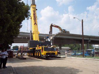
1 Recovery, Reuse, and Recycling of Debris From the Demolition of the Grace and Pearman Bridges at Charleston, South Carolina Fred Cooper, P.E. Earth Tech AECOM

2 Three Bridges Viewed From the Charleston Side

3 Work started with removal of the Grace off-ramp between King and Meeting Streets.

4 Ken Canty pointing out that supporting columns are numbered to ensure removal in the correct order.

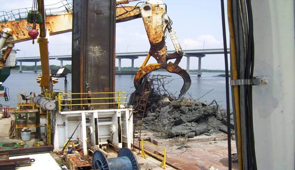
5 Debris being separated for reuse and recycling
6 FACT SPECIAL RECOGNITION Special recognition is given to Mr. Frank Starmer who is responsible for most of the spectacular deconstruction photographs in this presentation. The photos are used with Mr. Starmer s permission.

7 Recovered rebar being separated, and bunched.

8 Claws and Jaws Carefully grasping a bridge girder

9 and gently working the girder down..

10 to the ground. Awesome!
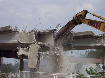
11 FACT Earth Tech AECOM Designed reconnection of city streets and I-26 / US 17 interchange improvements, Managed prime contractor s compliance with Joint State and Federal environmental permit for temporary impacts to wetlands, Designed the created wetlands at Waterfront Park in Mount Pleasant.


12 Looking toward Charleston Looking toward Mt. Pleasant Removing the roadway from the Pearman, leaving only the steel skeleton near SPA.

13 Grace s steel span. Bare steel of this nature can be easily recycled by the steel industry.

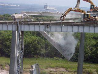
14 NOW THAT S A CLAW! BIGGER IS BETTER, AND THESE GUYS KNOW HOW TO USE IT.

15 Taking a safety break, because a thunderstorm can be a shocking experience.

16 The final layer of roadway is finally removed, and now


17 On to the Reinforced Concrete Piers, the Breakfast of Champions


18 Hammering out boxed girders


19 A Graceful Decent to Drum Island
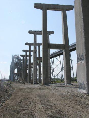

20 SURREAL STONEHENGE?

21 From Surreal to Surgical Careful Reverse Construction Over State Ports

22 Inland Area Cleanup State Ports Authority, Town Creek, Drum Island, and the Ravenel Bridge in the Distance, and

23 Remaining Piers in Shipping Channel June 1, 2006
24 About Those Piers The contractor must demonstrate that all parts of the Bridges have been removed down to or below elevations required, and that the waterways have been cleared to the satisfaction of Charleston District US Army Corps of Engineers (USACE) Commander. Q: How are we to satisfactorily document removal of piers and miscellaneous debris in the Cooper River? A: Provide Hydrographic Surveys of debris field including: 1. Bathometric contour mapping, 2. Side scan sonar survey, and

25 Topographic Map - Cooper River Bottom West of Shipping Channel

26 Topographic Map - Cooper River Bottom Town Creek

27 Magnetic Intensity Map - Cooper River Bottom West of Shipping Channel

28 Magnetic Intensity Map - Cooper River Bottom East of Shipping Channel

29 The Mighty Jay Cashman Sails to recover the remaining demolition debris from the floor of the Cooper River
30 Debris

31 And more debris Photographs document the work about 102 debris removal photos.
32 PROJECT RECORDS 240,292 tons of reinforced concrete placed in 12 off shore artificial reefs, 5,286 tons of debris used to create new artificial reef adjacent to a new observation pier at Mount Pleasant, and 24,668 tons of structural steel was recycled, TOTAL = 270,246 tons Vs. 261,000 tons bid.

33 HOW TO BUILD A REEF FROM RECOVERED DEMOLITION DEBRIS? A girder is being removed here over East Bay Street at night.

34 Note Claw at Right. This girder is being divided into smaller segments for easier transportation.

35 On Board the reef crew s boat, Jay Michael.

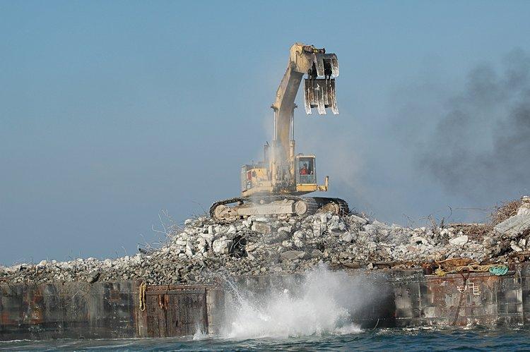
36 View from the Jay Michael heading out to the designated reef, and passing material being loaded onto a barge for another reef site.

37 DESIGNATED REEF DEPLOYMENT LOCATIONS

38 Course tracking with a small GPS to document our consistent outbound and inbound routes.
39 About an hour later - our reef destination with Brad's 345 and Rick's 750 positioned on the barge at the site.
40 As we approach, we can see that twin jaws are in sleep-mode.

41 Rick and Brad awaken their machines, the jaws stretch out, as if to yawn, good morning, and then the action starts

42 King of the Hill!
43 Jaws gently snaps up a reef segment
44 and gently tosses it

45 Placing the reinforced concrete debris at the reef site. (These guys make it look easy, and fun.)
46 SPLASH!

47 It takes two for the big tango

48 Gittin Busy!

49 Another surreal scene, ravenous jaws and claws toss parts from large civil structures into the ocean. (Kinda-like old school Sci-Fi!) Finishing up - a short conversation and then

50 After finishing up: first a short conversation and then

51 a little R&R as the Jay Michael heads home.

52 Nearing port and passing by a sailboat while the sun sets a picture made to order.
53 The sun says, good evening... we are home.
54 ARTIFICIAL REEF CONSTRUCTION PROJECT Largest reef construction project in South Carolina s history based on tonnage. Largest number of deployments (50), and Enhanced the largest number of reef sites of any project in South Carolina s history.

55 DNR Photo: Reef Fish and Invertebrates find a home in our recovered concrete and rebar debris.

56 Another DNR Photo: Our Recovered Concrete and Rebar make a good home for marine life. A good homes makes for happy fish, and that makes us happy too~!
57 FACT SIMULTANEOUS DE-CONSTRUCTION OF THE GRACE AND PEARMAN BRIDGES Bid for design and deconstruction included 261,000 tons of reinforced concrete and structural steel to be recovered and reused or recycled. Successfully completed by Jay Cashman, Inc. /Testa Corp., A Joint Venture (the Joint Venture), and their subcontractors, one being Earth Tech AECOM. Demonstrated that recovery, reuse, and recycling of demolition debris can reduce costs and benefit the environment.
Southeast Volusia Coastal Projects Update
 Southeast Volusia Coastal Projects Update Public Works Department Coastal Division August 15, 2016 2016 Dune Walkover Re-Decking Program Completed Dune Walkovers South End 8 th Ave. New Smyrna Beach* 12
UNDERWATER BRIDGE INSPECTION REPORT STRUCTURE NO OVER THE STRAIGHT RIVER DISTRICT 6 - RICE COUNTY
 UNDERWATER BRIDGE INSPECTION REPORT STRUCTURE NO. 66513 14 th STREET (MSAS NO. 103) OVER THE STRAIGHT RIVER DISTRICT 6 - RICE COUNTY PREPARED FOR THE MINNESOTA DEPARTMENT OF TRANSPORTATION BY COLLINS ENGINEERS,
UNDERWATER BRIDGE INSPECTION REPORT STRUCTURE NO B WABASHA STREET SOUTH BOUND (MASA 235 SB)
") UNDERWATER BRIDGE INSPECTION REPORT STRUCTURE NO. 62555B WABASHA STREET SOUTH BOUND (MASA 235 SB) OVER THE MISSISSIPPI RIVER CITY OF ST. PAUL OCTOBER 31, 2012 PREPARED FOR THE MINNESOTA DEPARTMENT OF TRANSPORTATION
UNDERWATER BRIDGE INSPECTION REPORT STRUCTURE NO. 62555B WABASHA STREET SOUTH BOUND (MASA 235 SB) OVER THE MISSISSIPPI RIVER CITY OF ST. PAUL OCTOBER 31, 2012 PREPARED FOR THE MINNESOTA DEPARTMENT OF TRANSPORTATION
Vieques Underwater Demonstration Project
 Vieques Underwater Demonstration Project NOAA Office of Response and Restoration National Ocean Service 2006-2007 2007 University of New Hampshire Joint Hydrographic Center 2006 Science Application International
IF YOU BUILD IT THEY WILL COME
 IF YOU BUILD IT THEY WILL COME Delaware s Artificial Reef Program is funded under the Federal Aid in Fisheries Restoration Act by the Delaware Division of Fish and Wildlife ABOUT THE COVER The tugs Fels
Estimated on-the-ground start and end dates: 1 June October 2018
 A. Applicant Information Name of Organization: U.S. Army Corps of Engineers, Carlyle Lake 801 Lake Road, Carlyle, IL 62231 Contact Information: Robert Wilkins, Operations Manager, (618) 594-2484, Robert.Wilkins@usace.army.mil
Information for File # SEW
 Information for File #2014-02744-SEW Applicant: Minnesota Department of Transportation (MnDOT), District 3; c/o Mr. Robert Nibbe Corps Contact: Sarah Wingert, U.S. Army Corps of Engineers, 180 5 th Street
STATUS REPORT FOR THE SUBMERGED REEF BALL TM ARTIFICIAL REEF SUBMERGED BREAKWATER BEACH STABILIZATION PROJECT FOR THE GRAND CAYMAN MARRIOTT HOTEL
 August 23 STATUS REPORT FOR THE SUBMERGED REEF BALL TM ARTIFICIAL REEF SUBMERGED BREAKWATER BEACH STABILIZATION PROJECT FOR THE GRAND CAYMAN MARRIOTT HOTEL performed by Lee E. Harris, Ph.D., P.E. Consulting
TROUT CREEK WATERSHED (Second Year of Snowline Data)
") Extent of Snow Cover During the 2002 Spring Freshet For the TROUT CREEK WATERSHED (Second Year of Snowline Data) (Penticton Forest District) 1.0 INTRODUCTION The extent of snow cover over a watershed basin
Extent of Snow Cover During the 2002 Spring Freshet For the TROUT CREEK WATERSHED (Second Year of Snowline Data) (Penticton Forest District) 1.0 INTRODUCTION The extent of snow cover over a watershed basin
Texas Department of Transportation s Gulf Intracoastal Waterway Capacity Study. GICA 112 th Annual Seminar July 28, 2017
 Texas Department of Transportation s Gulf Intracoastal Waterway Capacity Study GICA 112 th Annual Seminar July 28, 2017 Study Purpose Determine if current levels of vessel activity on the Texas segment
Certified Professionals in Hydrographic Solutions
 Certified Professionals in Hydrographic Solutions Client Satisfaction is our Deliverable Port of Brisbane Pty Ltd Port Surveys Certified Professionals in Hydrographic Surveying Tel +61 (0) 7 3258 4820
UNDERWATER BRIDGE INSPECTION REPORT DISTRICT 8 - LAC QUI PARLE COUNTY
 UNDERWATER BRIDGE INSPECTION REPORT STRUCTURE NO. 6391 CSAH NO. 33 OVER THE MINNESOTA RIVER DISTRICT 8 - LAC QUI PARLE COUNTY PREPARED FOR THE MINNESOTA DEPARTMENT OF TRANSPORTATION BY COLLINS ENGINEERS,
UNDERWATER BRIDGE INSPECTION REPORT METRO DISTRICT - ANOKA COUNTY
 UNDERWATER BRIDGE INSPECTION REPORT STRUCTURE NO. 02545 CR NO. 116 OVER THE RUM RIVER METRO DISTRICT - ANOKA COUNTY SEPTEMBER 9, 2012 PREPARED FOR THE MINNESOTA DEPARTMENT OF TRANSPORTATION BY COLLINS
UNDERWATER BRIDGE INSPECTION REPORT DISTRICT 8 - LAC QUI PARLE COUNTY
 UNDERWATER BRIDGE INSPECTION REPORT STRUCTURE NO. 6391 CSAH NO. 33 OVER THE MINNESOTA RIVER DISTRICT 8 - LAC QUI PARLE COUNTY OCTOBER 22, 2012 PREPARED FOR THE MINNESOTA DEPARTMENT OF TRANSPORTATION BY
Appendix J: Q1-Highway 35 Route Construction Plan
 PSC REF#:150055 Wisconsin CPCN Appendix J Appendix J: Q1-Highway 35 Route Construction Plan Public Service Commission of Wisconsin RECEIVED: 06/29/11, 8:51:24 AM Hampton Rochester La Crosse 345 kv Transmission
DEPARTMENT OF THE ARMY GALVESTON DISTRICT, CORPS OF ENGINEERS P.O. BOX 1229 GALVESTON, TEXAS CESWG-CDR (1145)
") DEPARTMENT OF THE ARMY GALVESTON DISTRICT, CORPS OF ENGINEERS P.O. BOX 1229 GALVESTON, TEXAS 77553-1229 REPLY TO ATTENTION OF CESWG-CDR (1145) TBD MEMORANDUM FOR All Galveston District Personnel. SUBJECT:
DEPARTMENT OF THE ARMY GALVESTON DISTRICT, CORPS OF ENGINEERS P.O. BOX 1229 GALVESTON, TEXAS 77553-1229 REPLY TO ATTENTION OF CESWG-CDR (1145) TBD MEMORANDUM FOR All Galveston District Personnel. SUBJECT:
Perched Box Caisson Overview. January 2014
 Perched Box Caisson Overview January 2014 Why perched box caissons? Perched box caissons are used to construct the portion of the river piers that will support the steel arch spans Construction can occur
Final Waterborne Commerce Statistics
 Final Waterborne Commerce Statistics For Calendar Year 16 Waterborne Commerce National Totals And Selected Inland Waterways For Multiple Years Institute for Water Resources Navigation and Civil Works Decision
U.S. Army Corps of Engineers
 A. U.S. Army Corps of Engineers Kevin Parsons, Natural Resources Specialist 500 Resource Management Drive West Point, GA 31833 706-645-2937 Kevin.M.Parsons@usace.army.mil B. Underwater Structure Enhancement
N.Y. / REGION INFRASTRUCTURE Going Up! A Bridge Makes Way for Bigger Ships
 N.Y. / REGION INFRASTRUCTURE Going Up! A Bridge Makes Way for Bigger Ships By KATE ASCHERMARCH 21, 2014 Advertisement When it opened in 1931, the Bayonne Bridge with its parabolic arch connecting Staten
Visiting Lake Macquarie
 Visiting Lake Macquarie Lake Macquarie is the largest coastal salt water lake in Australia and is a prime boating destination for both small and large vessels. Many sailing regattas and fishing activities
Rio Intersection Traffic Restrictions Begin Monday
 May 18, 2016 8 Rio Intersection Traffic Restrictions Begin Monday This special edition of the Route 29 Solutions e mail newsletter includes everything you need to know about the May 23 through September
Ballast. Stability Lab Experiment. Have you ever been in a boat at sea in large waves? The boat moves up and down as the waves pass under the boat.
 Ballast & Stability Lab Experiment Have you ever been in a boat at sea in large waves? The boat moves up and down as the waves pass under the boat. In the Gulf of Mexico and other areas of the world, waves
Weymouth - Abington Route 18 Widening and Reconstruction Project File No
 Weymouth - Abington Route 18 Widening and Reconstruction Project File No. 601630 PROJECT LOCATION Project Limit Previously Completed Signalized Intersections (Typical) Route 18 Widening Bridge No. W-32-013
Kerr Lake Vegetation Survey. October November Report submitted by NC State University. Background
 Kerr Lake Vegetation Survey October November 2012 Report submitted by NC State University Background Hydrilla (Hydrilla verticillata) is a non-native invasive submersed aquatic plant. This plant was first
UNDERWATER BRIDGE INSPECTION REPORT DISTRICT 1 PINE COUNTY
 UNDERWATER BRIDGE INSPECTION REPORT STRUCTURE NO. 58551 CSAH NO. 41 OVER THE KETTLE RIVER DISTRICT 1 PINE COUNTY JULY 28, 2012 PREPARED FOR THE MINNESOTA DEPARTMENT OF TRANSPORTATION BY COLLINS ENGINEERS,
RLRC COMMUNITIES EAST GRAND FORKS AREA CHARACTER THE RED LAKE RIVER & THE RED RIVER OF THE NORTH CONFLUENCE EAGLE POINT BOAT LAUNCH DESIGN
 AREA CHARACTER THE RED LAKE RIVER & THE RED RIVER OF THE NORTH CONFLUENCE EAGLE POINT BOAT LAUNCH DESIGN DESIGN DETAILS 135 AREA CHARACTER East Grand Forks a city of 7,501 people is located across the
UNDERWATER BRIDGE INSPECTION REPORT STRUCTURE NO CSAH NO. 101 OVER THE MINNESOTA RIVER DISTRICT 8 - REDWOOD COUNTY
 UNDERWATER BRIDGE INSPECTION REPORT STRUCTURE NO. 7149 CSAH NO. 101 OVER THE MINNESOTA RIVER DISTRICT 8 - REDWOOD COUNTY PREPARED FOR THE MINNESOTA DEPARTMENT OF TRANSPORTATION BY COLLINS ENGINEERS, INC.
UNDERWATER BRIDGE INSPECTION REPORT STRUCTURE NO CSAH NO. 7 OVER THE SNAKE RIVER DISTRICT 1 - PINE COUNTY
 UNDERWATER BRIDGE INSPECTION REPORT STRUCTURE NO. 58506 CSAH NO. 7 OVER THE SNAKE RIVER DISTRICT 1 - PINE COUNTY PREPARED FOR THE MINNESOTA DEPARTMENT OF TRANSPORTATION BY COLLINS ENGINEERS, INC. JOB NO.
High Definition Laser Scanning (HDS) Underwater Acoustic Imaging and Profiling
 Underwater Acoustic Imaging and Profiling") High Definition Laser Scanning (HDS) Underwater Acoustic Imaging and Profiling Images at Depth: The Use of Acoustic Imaging on Large River Crossings A Case Study AGENDA Background of project Review of
High Definition Laser Scanning (HDS) Underwater Acoustic Imaging and Profiling Images at Depth: The Use of Acoustic Imaging on Large River Crossings A Case Study AGENDA Background of project Review of
Marine Math. A 5 th Grade Field Trip Guide to The Texas State Aquarium STUDENT BOOKLET
 Marine Math A 5 th Grade Field Trip Guide to The Texas State Aquarium STUDENT BOOKLET Copyright Erin Saenz, 2010. Permission granted for educational purposes only. This permission does not extend to copying
Kasaan to Goose Creek Road Project Project Description U.S. Army Corps of Engineers Permit The following table presents the mile point of the culverte
 Kasaan to Goose Creek Road Project Project Description U.S. Army Corps of Engineers Permit The following table presents the mile point of the culverted open water crossings, name of water crossing if known,
COAST GUARD ADVISORY NOTICE (CGAN ) To: Distribution Date: September 1, 2017
 To: Distribution Date: September 1, 2017") Commander United States Coast Guard Sector New York 212 Coast Guard Drive Staten Island, NY 10305 Staff Symbol: (spw) Phone: (718) 354-2353 Fax: (718) 354-4190 COAST GUARD ADVISORY NOTICE (CGAN 2017-016)
Commander United States Coast Guard Sector New York 212 Coast Guard Drive Staten Island, NY 10305 Staff Symbol: (spw) Phone: (718) 354-2353 Fax: (718) 354-4190 COAST GUARD ADVISORY NOTICE (CGAN 2017-016)
TOWN OF DENNIS 10 YR COMPREHENSIVE DREDGE PERMIT SEPTEMBER 10, 2013
 TOWN OF DENNIS 10 YR COMPREHENSIVE DREDGE PERMIT SEPTEMBER 10, 2013 WHAT IS IT? ALL NECESSARY PERMITS FOR DREDGING FOR PORTIONS OF BASS RIVER, SWAN POND RIVER, SESUIT HARBOR AND CHASE GARDEN CREEK ONE
Marine Math. A 4 th Grade Field Trip Guide to The Texas State Aquarium STUDENT BOOKLET
 Marine Math A 4 th Grade Field Trip Guide to The Texas State Aquarium STUDENT BOOKLET Copyright Erin Saenz, 2010. Permission granted for educational purposes only. This permission does not extend to copying
STUDY PROCESS & SCHEDULE
 STUDY PROCESS & SCHEDULE Route Centennial Bridge Study KDOT Project No. -52 KA-3229-01 STUDY OVERVIEW STUDY SCHEDULE The Kansas Department of Transportation (KDOT) has identified a future need to replace
MONTGOMERY COUNTY FIRE AND RESCUE SERVICE SWIFT WATER TEAM TRAINING PROGRAM CERTIFICATION TEST FOR SWIFT WATER BOAT OPERATOR
 MONTGOMERY COUNTY FIRE AND RESCUE SERVICE SWIFT WATER TEAM TRAINING PROGRAM CERTIFICATION TEST FOR SWIFT WATER BOAT OPERATOR Candidate Name: ID# : Station/Shift/Dept: Evaluator: Boat Support #: Boat #:
UNDERWATER BRIDGE INSPECTION REPORT STRUCTURE NO CSAH NO. 9 OVER THE BLUE EARTH RIVER DISTRICT 7 - BLUE EARTH COUNTY
 UNDERWATER BRIDGE INSPECTION REPORT STRUCTURE NO. 07542 CSAH NO. 9 OVER THE BLUE EARTH RIVER DISTRICT 7 - BLUE EARTH COUNTY PREPARED FOR THE MINNESOTA DEPARTMENT OF TRANSPORTATION BY COLLINS ENGINEERS,
Lee E. Harris, Ph.D., P.E. Assoc. Professor of Ocean Engineering. Doug Bowlus and Ashley Naimaster Ocean Engineering Graduate Students
 FLORIDA TECH OCEAN ENGINEERING PROFESSOR LEE HARRIS AND HIS GRADUATE STUDENTS ASSIST WITH POST-HURRICANE IVAN CORAL REEF RESTORATION IN THE CAYMAN ISLANDS Lee E. Harris, Ph.D., P.E. Assoc. Professor of
UMass Boston Waterfront at a glance
 UMass Boston Waterfront at a glance Fox Point Pavilion Over the years, the Fox Point Landing has been a rest area, an outdoor classroom and a general meeting place for students, staff and faculty of the
ROYAL MELBOURNE YACHT SQUADRON. Strategic Plan
 ROYAL MELBOURNE YACHT SQUADRON Strategic Plan 2014-18 VISION AND MISSION VISION A St Kilda icon and Melbourne s best sailing experience MISSION The Royal Melbourne Yacht Squadron: Promotes participation
State of Nevada Department of Transportation Materials Division
 State of Nevada Department of Transportation Materials Division METHOD OF TEST FOR EVALUATION OF PAVEMENT RIDE QUALITY USING INERTIAL PROFILING SYSTEMS SCOPE This test method describes the procedure used
With a team of highly qualified divers Vision offers a wide range of services including;
 Commercial Diving Services With a team of highly qualified divers Vision offers a wide range of services including; Civils Diving Services Inspections, Construction and maintenance on bridges, piles, quay
CE 535, Spring 2002 Preliminary Design Example 1 / 6
 CE 535, Spring 2002 Preliminary Design Example 1 / 6 Perform a preliminary design for a bridge on a state highway over a large creek in rural Alabama. Produce a construction layout drawing showing profile
Chart Features Maritime maps and Admiralty charts have these features:
 Introduction to Charts A chart or map of the area is an important safety item to carry on board. It allows the Master to obtain knowledge of the area to be travelled, and indicates the navigable channels
FINDING OF NO SIGNIFICANT IMPACT
 DEPARTMENT OF THE ARMY CHARLESTON DISTRICT, CORPS OF ENGINEERS 69A HAGOOD AVENUE CHARLESTON, SOUTH CAROLINA 29403-5107 FINDING OF NO SIGNIFICANT IMPACT EDISTO BEACH COASTAL STORM DAMAGE REDUCTION GENERAL
Environmental Review and Permitting for Wild Trout
 Environmental Review and Permitting for Wild Trout Tom Shervinskie Wild Trout Summit Watershed Analysis Section August 26, 2017 Division of Environmental Services The mission of the Pennsylvania Fish and
AID VERIFIER QUIZ. 1. How often is the Light List published? a. One a year b. Twice a year c. Every Month d. Quarterly
 Qualification as an Aid Verifier in the Auxiliary presumes a knowledge of navigational aids above that of the ordinary member. Questions on the subject may be directed to the AV as he/she is considered
HARBOR INFRASTRUCTURE INVENTORIES Fairport Harbor, OH
 HARBOR INFRASTRUCTURE INVENTORIES Fairport Harbor, OH Harbor Location: Fairport Harbor is located at the mouth of the Grand River on the southern shore of Lake Erie in the city of Fairport, OH, approximately
Apostle Islands National Seashore
 Apostle Islands National Seashore David Speer & Phillip Larson October 2 nd Fieldtrip Report Table of Contents Introduction 1 Stop 1: Apostle Island Boat Cruise 1 Stop 2: Coastal Geomorphology 5 Stop 3:
Challenges in determining water surface in airborne LiDAR topobathymetry. Amar Nayegandhi, Dewberry 15 th Annual JALBTCX Workshop, June 11 th 2014
 Challenges in determining water surface in airborne LiDAR topobathymetry Amar Nayegandhi, Dewberry 15 th Annual JALBTCX Workshop, June 11 th 2014 Why topobathy LiDAR? Complements acoustic (multi-beam sonar)
Storm Damage Floating Culverts & Other Inlet Issues
 Storm Damage Floating Culverts & Other Inlet Issues Mark Bailey, PE - Hydraulic Manager, INDOT Dale Sedler, PE - Sr. Hydraulic Engineer, INDOT Road School 2016 What causes a culvert to float? 1. Accumulation
1) INTRODUCTION 2) THE UNFAIR ADVANTAGE
 INTRODUCTION 2) THE UNFAIR ADVANTAGE") 1 1) INTRODUCTION 2) THE UNFAIR ADVANTAGE and Stingray earth anchors are driven tipping plate soil anchors for reaction of tensile loads. anchors have ultimate capacities up to 20 tons, and Stingray anchors
1 1) INTRODUCTION 2) THE UNFAIR ADVANTAGE and Stingray earth anchors are driven tipping plate soil anchors for reaction of tensile loads. anchors have ultimate capacities up to 20 tons, and Stingray anchors
Pier 8 Wave Overtopping Analysis (65 Guise Street East) Our File:
 Our File:") Shoreplan Engineering Limited 55 Eglinton Avenue E., Suite 800 Toronto, ON Canada M4P 1G8 T) 416.487.4756 F) 416.487.5129 E) mail@shoreplan.com March 31, 2016 Mr. Ed English Senior Project Manager Waterfront
Shoreplan Engineering Limited 55 Eglinton Avenue E., Suite 800 Toronto, ON Canada M4P 1G8 T) 416.487.4756 F) 416.487.5129 E) mail@shoreplan.com March 31, 2016 Mr. Ed English Senior Project Manager Waterfront
2.6 Dry Bulk, Break-Bulk, and Yachts and Vehicles Cargo Market Assessment
 2.6 Dry, Break-, and Yachts and Vehicles Cargo Market Assessment 2.6.1 Forecast Summary Annual cargo demand for dry bulk, break-bulk, yachts and vehicles was forecast under three scenarios (see Figure
PROJECT FACT SHEET March 21, 2018
 SITE CHALLENGES & PROJECT BACKGROUND In 2014, the City of Aspen identified the Castle Creek Bridge and Hallam Street corridor as a deficient link in Aspen s bicycle and pedestrian network. Safe and efficient
Plymouth Thanksgiving Parade Your Invitation photos and text from Andrew Butler
 Flotilla 65, 1 st District Northern Volume 9, No. 5 October 2017 Plymouth Thanksgiving Parade 2017 - Your Invitation photos and text from Andrew Butler On Saturday November 18 the annual Thanksgiving Day
Gold Coast Barges-Vessel Information Sheet Vessel Name: 'ICEBREAKER'
 Gold Coast Barges-Vessel Information Sheet Vessel Name: 'ICEBREAKER' The versatile workhorse of the waterfront maintenance industry! Length: 12m Beam: 6m Draft: 0.9max Height above waterline: 800mm unloaded
PROJECT FACT SHEET May 25, 2018
 SITE CHALLENGES & PROJECT BACKGROUND In 2014, the City of Aspen identified the Castle Creek Bridge and Hallam Street corridor as a deficient link in Aspen s bicycle and pedestrian network. Safe and efficient
Toll Rate Public Hearing
 Toll Rate Public Hearing I-77 Express Toll Rate Hearing September 13, 2018 AGENDA AND HOUSEKEEPING Speaker Signup Bathrooms/Exits Facebook Live Introductions Thanks and Recognition 6:30-6:35 6:35-6:55
Redondo Beach Boat Launch Ramp Facility
 Redondo Beach Boat Launch Ramp Facility Feasibility Report for the California Department of Boating and Waterways 2015 Grant Cycle For the City of Redondo Beach Submitted by March 13, 2014 Table of Contents
09/28/2011 NEW/UPDATED ROAD CONSTRUCTION AND RESTRICTIONS:
 MONTANA ROAD CONSTRUCTION REPORT 09/28/2011 NEW/UPDATED ROAD CONSTRUCTION AND RESTRICTIONS: US 191 - WARM SPRINGS CREEK BRIDGE MILE POST 10.0 TO 10.1 SITE IS 10 MILES NORTH OF LEWISTOWN, MT. CONTRACTOR
HOOD RIVER YACHT CLUB WEDNESDAY NIGHT SPRING SERIES 2016 APRIL 27; MAY 4, 11, 18, 25; JUNE 1 SAILING INSTRUCTIONS
 HOOD RIVER YACHT CLUB WEDNESDAY NIGHT SPRING SERIES 2016 APRIL 27; MAY 4, 11, 18, 25; JUNE 1 SAILING INSTRUCTIONS 1. RULES 1.1 This regatta will be governed by the rules as defined in the Racing Rules
Innovative Technologies for a Resilient Marine Transportation System
 Innovative Technologies for a Resilient Marine Transportation System Transportation Research Board MG John Peabody, P.E. Deputy Commanding General for Civil and Emergency Operations, U.S. Army Corps of
Ships 2-Reefs Program Annual Report
 Florida Fish and Wildlife Conservation Commission Ships 2-Reefs Program 2016-17 Annual Report Ships-2-Reefs Program In 2008, the Florida Legislature passed Ships-2-Reefs Program legislation (SB 432), Chapter
L Jll111I.6 3 = MICROCOPy RESOLUTION TEST CHART L40. NATIONAt TIRFAII nlf qtanpar[os IQ64 A
 RD-RI52 286 EXPLORATORY MAGNETIC SURVEY OF NURRELL'S INLET SOUTH Ido CAROLINA AND PORTION..(U) GULF SOUTH RESEARCH INST BATON ROUGE LA A R SALTUS APR 79 DACNS4-77-C-1139 IE IIIIIIIIIIII UNCLASSIFIED F/G
Coastal Harbors and Waterways, NC (Shallow Draft Navigation) (O&M)
 (O&M)") Coastal Harbors and Waterways, NC (Shallow Draft Navigation) (O&M) Shallow draft coastal harbors include a subsistence harbor at Silver Lake CONGRESSIONAL DISTRICT: NC 3, 7 DATE: 23 April 2018 1. AUTHORIZATION:
Coastal Harbors and Waterways, NC (Shallow Draft Navigation) (O&M) Shallow draft coastal harbors include a subsistence harbor at Silver Lake CONGRESSIONAL DISTRICT: NC 3, 7 DATE: 23 April 2018 1. AUTHORIZATION:
FINAL REPORT. Yonkers Creek Migration Barrier Removal Project Wonderstump Road Del Norte County. Submitted By:
 FINAL REPORT Yonkers Creek Migration Barrier Removal Project Wonderstump Road Del Norte County Submitted By: Del Norte County Community Development Department Yonkers Creek Migration Barrier Removal Project
DRAFT. October 17, 2014 File No Mr. Brendhan Zubricki Town Administrator Essex Town Hall 30 Martin Street Essex, MA.
 GZA GeoEnvironmental, Inc. Engineers and Scientists October 17, 2014 File No. 18.0171857.00 Mr. Brendhan Zubricki Town Administrator Essex Town Hall 30 Martin Street Essex, MA. 01929 DRAFT Re: Essex River
The 2017 Panama City Beaches Beach Interim Renourishment Project. Answers to Common Questions
 The 2017 Panama City Beaches Beach Interim Renourishment Project The fourth renourishment of the Panama City Beaches will be under construction during March and April 2017, with a planned completion by
ICE and WATER RESCUE
 Page 1 of 8 Last Revised 12/12 40.01 Scope: The Town of Menasha Fire Department is certified to the technician level according to NFPA 1670. Due to a lack of equipment and resources, emergency responses
Annex E Bridge Pier Protection Plan
 Annex E Bridge Pier Protection Plan Table E1 Bridge Types and Locations Table E2 Flow Conditions For River Sections Figure E1 Bridge Abutment Protection Figure E2 Bridge Pier Protection Figure E3 Central
Great Lakes Shipping Across The Country & Around The World Great Lakes Floor Map: Shipping and Receiving Cargo on the Great Lakes
 Lesson #1 Lesson #2 Great Lakes Shipping Across The Country & Around The World Great Lakes Floor Map: Shipping and Receiving Cargo on the Great Lakes Laura Mikesell Laura.Mikesell@gpschools.org Parcells
OYSTER REEF RESTORATION; RESTORING ECOLOGICAL FUNCTION
 OYSTER REEF RESTORATION; RESTORING ECOLOGICAL FUNCTION Paul Jensen, David Buzan, and Ka-Leung Lee; Atkins Mark Dumesnil and Julie Sullivan; The Nature Conservancy Presentation Overview The Nature Conservancy
TECHNICAL MEMORANDUM 002 EMORANNO. 001
 TECHNICAL MEMORANDUM 002 EMORANNO. 001 To: Jack Synder, P.E. EES Consulting From: Mort McMillen, P.E. Paul Larson, SE Date: October 13, 2010 Project: Cc: Taylor Bowen Subject: Technical Memorandum (TM)
The Evolution of an Autonomous Unmanned Surface Vessel and Software for Hydrographic Survey
 The Evolution of an Autonomous Unmanned Surface Vessel and Software for Hydrographic Survey Paul Donaldson In 2017, Leidos, Inc. participated in both the Gulf of Mexico Unmanned Systems Operational Demonstration
Western Canadian Spill Services Ltd. Field Testing Exercise Report
 Western Canadian Spill Services Ltd. Field Testing Exercise Report Wednesday, July 15, 2009 Clearwater River, Rocky Mountain House, AB Background Western Canadian Spill Services Ltd. (WCSS) held a field
Water Resources Report RKLD Annual Meeting July 30, 2016
 Water Resources Report RKLD Annual Meeting 2016 July 30, 2016 Topics Hydrology Report Indianford Dam trash rack cleanout performance Experimental Project update Review of PAS project Twin floods- 1 to
Implementation Report # False Creek Bridges
 Implementation Report #1 2013-04-24 False Creek Bridges ECONOMY PEOPLE ENVIRONMENT Intro Council Requested Report Back Topics Progress on Planning for Broadway Subway False Creek Bridges Local Transit
UNDERWATER ARCHAEOLOGY Pickles Reef Florida Keys National Marine Sanctuary
 UNDERWATER ARCHAEOLOGY Pickles Reef Florida Keys National Marine Sanctuary MAHS Survey and Field School 2011 MAHS returned to Florida in June of 2011 to continue a survey of Pickles Reef begun in 2010.
East Central Florida Region Matt Culver, Brevard County James Gray, Indian River County Jim Oppenbourn, St. Lucie County Kathy Fitzpatrick, Martin
 James Gray, Indian River County January 14, 2015 East Central Florida Region Matt Culver, Brevard County James Gray, Indian River County Jim Oppenbourn, St. Lucie County Kathy Fitzpatrick, Martin County
Dredging Keeping Our Underwater Highways Open
 Dredging Keeping Our Underwater Highways Open Sedimentation Material that falls to the bottom of a liquid is called sediment. If enough sediment deposits to build a shallow spot on the river or ocean bottom,
KCRC Ma On Shan Line. Railway Development in Hong Kong. Tai Wai Station and Maintenance Centre
 Railway Development in Hong Kong KCRC Ma On Shan Line Tai Wai Station and Maintenance Centre Overview of the Maintenance Centre of the Ma On Shan Line at Tai Wai, as seen in early 2002. The Centre is a
An Easier Commute. Learn how to use I-77 Express to save you time.
 An Easier Commute Learn how to use I-77 Express to save you time PUBLIC-PRIVATE PARTNERSHIP I-77 Express is the first-ever toll lane public-private partnership with NCDOT I-77 Mobility Partners is financing,
TYPES OF FOUNDATION. Superstructure. Substructure. Foundation
 TYPES OF FOUNDATION Introduction: The lowest artificially built part of a structure which transmits the load of the structure to the soil lying underneath is called foundation. The supporting part of a
Use of Roller Compacted Concrete By GDOT. Presented By: Joe W. Sheffield, PE Georgia Department of Transportation District Engineer, Tifton, GA
 Use of Roller Compacted Concrete By GDOT Presented By: Joe W. Sheffield, PE Georgia Department of Transportation District Engineer, Tifton, GA First Use of RCC By Georgia DOT I-285 Atlanta, GA 2005 Traffic:
OFFICE OF STRUCTURES MANUAL FOR HYDROLOGIC AND HYDRAULIC DESIGN CHAPTER 11 APPENDIX B TIDEROUT 2 USERS MANUAL
 OFFICE OF STRUCTURES MANUAL FOR HYDROLOGIC AND HYDRAULIC DESIGN CHAPTER 11 APPENDIX B TIDEROUT 2 USERS MANUAL APRIL 2011 APRIL 2011 Page 1 Preface TIDEROUT 2, Build 1.22 dated June 29, 2006 is the current
PLACEMENT OF SIGNS RECOMMENDED PRACTICES SUB-SECTION
 Page 1 of 6 RECOMMENDED PRACTICES PART SECTION SUB-SECTION HIGHWAY SIGNS GENERAL General Proper positioning of signs is an important element in the overall control of traffic within a roadway network.
APPENDIX C DIVING. Section I. General
 APPENDIX C DIVING Section I. General PURPOSE a. Engineer divers support all diving missions in the theater of operations. Engineer support in the communication zone is provided on an area basis; and in
LOCAL NOTICE TO MARINERS
 USCG Notice to Mariners 3/26/15 (View full Notice here) LNM 12/15 Coast Guard District 1 : U.S. Department of Homeland Security United States Coast Guard LOCAL NOTICE TO MARINERS COASTAL WATERS FROM EASTPORT,
APC Operating Procedures Oil Tankers
 APC Operating Procedures Oil Tankers August 2013 The APC Operating Procedures were developed to aid the Master and Operator of oil tankers in ensuring all aspects of the APC are complied with when transiting
UNDERWATER BRIDGE INSPECTION REPORT DISTRICT 4 - OTTER TAIL COUNTY
 UNDERWATER BRIDGE INSPECTION REPORT STRUCTURE NO. L0885 TWP NO. 970 OVER THE OTTER TAIL RIVER DISTRICT 4 - OTTER TAIL COUNTY PREPARED FOR THE MINNESOTA DEPARTMENT OF TRANSPORTATION BY COLLINS ENGINEERS,
Homework 2 PROBLEM No. 1
 PROBLEM No. 1 In accordance with the project requirements, the contractor has obtained a 4 diameter core from below the shaft bottom. The core run was 5.0 and the total rock recovered was 4.2. A total
Intergovernmental Oceanographic Commission. International Tsunami Information Center
 W W W.T S U N A M I W AV E.I N F O Intergovernmental Oceanographic Commission INTERNATIONAL TSUNAMI INFORMATION CENTER International Tsunami Information Center United Nations Educational, Scientific and
The Blessing of the Fleet Regatta
 THE BARNACLE CUP SAILORS AND THE ST MARY S RYKEN & LEONARDTOWN HIGH SCHOOL SAILING TEAMS PRESENT: The Blessing of the Fleet Regatta October 5 th, 2013 www.barnaclecup.com For more information, contact
BENEFIT-COST ANALYSIS OF HARBOR DREDGING ON THE GREAT LAKES
 Middle States Geographer, 997,30:55-6 BENEFT-COST ANALYSS OF HARBOR DREDGNG ON THE GREAT LAKES Raymond W. Waxmonsk:y Department of Geography & Planning Buffalo State College Buffalo, NY 4222 ABSTRACT:
BRUCE HAMMER SUCCESS STORY, BRIDGE PILING Model SGH-4719 Pile Hammer (Max. Energy 89.3 ton.m)
") The Bruce SGH-4719 successfully completed the pile driving of Sakonnet River Bridge at RI, USA By Portsmouth Patch (www.patch.com), August 27, 2010 Government RI DOT : Pile Driving Completed at Sakonnet
The Bruce SGH-4719 successfully completed the pile driving of Sakonnet River Bridge at RI, USA By Portsmouth Patch (www.patch.com), August 27, 2010 Government RI DOT : Pile Driving Completed at Sakonnet
APPENDIX C. Fluvial and Tidal Hydraulics Report
 APPENDIX C Fluvial and Tidal Hydraulics Report BUENA VISTA LAGOON ENHANCEMENT PROJECT FLUVIAL AND TIDAL HYDRAULICS ANALYSES Prepared for: SANDAG 401 B Street, Suite 800 San Diego, California 92101 Contact:
3.7 River Navigation Affected Environment
 3 Affected Environment and Environmental Consequences 3.7 River Navigation 3.7.1 Affected Environment Sterling Highway MP 45 60 Project Final EIS The Kenai River is approximately 82 river miles long in
UNDERWATER BRIDGE INSPECTION REPORT STRUCTURE NO MSAS 123 (2 ND AVE. SW) OVER THE CANNON RIVER CITY OF FARIBAULT, RICE COUNTY
 OVER THE CANNON RIVER CITY OF FARIBAULT, RICE COUNTY") UNDERWATER BRIDGE INSPECTION REPORT STRUCTURE NO. 66546 MSAS 123 (2 ND AVE. SW) OVER THE CANNON RIVER CITY OF FARIBAULT, RICE COUNTY SEPTEMBER 13, 2012 PREPARED FOR THE MINNESOTA DEPARTMENT OF TRANSPORTATION
UNDERWATER BRIDGE INSPECTION REPORT STRUCTURE NO. 66546 MSAS 123 (2 ND AVE. SW) OVER THE CANNON RIVER CITY OF FARIBAULT, RICE COUNTY SEPTEMBER 13, 2012 PREPARED FOR THE MINNESOTA DEPARTMENT OF TRANSPORTATION