G. Meadows, H. Purcell and L. Meadows University of Michigan
|
|
|
- Noreen Singleton
- 5 years ago
- Views:
Transcription
1 G. Meadows, H. Purcell and L. Meadows

2 Over 80% of all surf related rescues are attributable to Rip Currents According to the U.S. Lifesaving Association, in 1999 there were over 23,000 rip related rescues along U.S. beaches It is estimated that each year nearly 100 people drown from rip currents 12 deaths in Michigan in
3

4

5 Neck Strongest current Head Current disperses beyond the breaker line Longshore Current or Feeder Feeds the rip Breaker Zone Slow onshore movement between rips Head Neck Onshore Transport Feeder

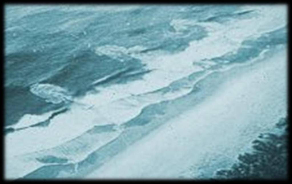
6 Swift, narrow currents that carry water, sand and debris off shore As long as 1 kilometer, Ranging from less than 10 to over 30 m in width With maximum velocities over 2 m/s Strongest outward moving current occurs where the wave height is lowest attracting unwary bathers to the more tranquil looking area of the beach.

7 Sea Waves in the process of generation by the wind Sharp angular crests Swell Waves that have traveled out of generation area Flatter crests Longer period Pinet, 2003

8 Variable Longshore Bathymetry Variations in Longshore Wave Height Intersecting Wave Trains Edge Waves Coastal Structures
 move more sand Bigger bars Bigger")
9 Bigger waves induce larger currents Smaller waves create weaker, more numerous rip currents Well organized waves induce more organized currents Increased velocities (waves and currents) move more sand Bigger bars Bigger channels

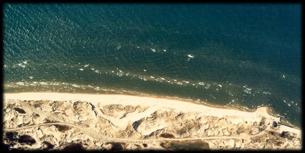
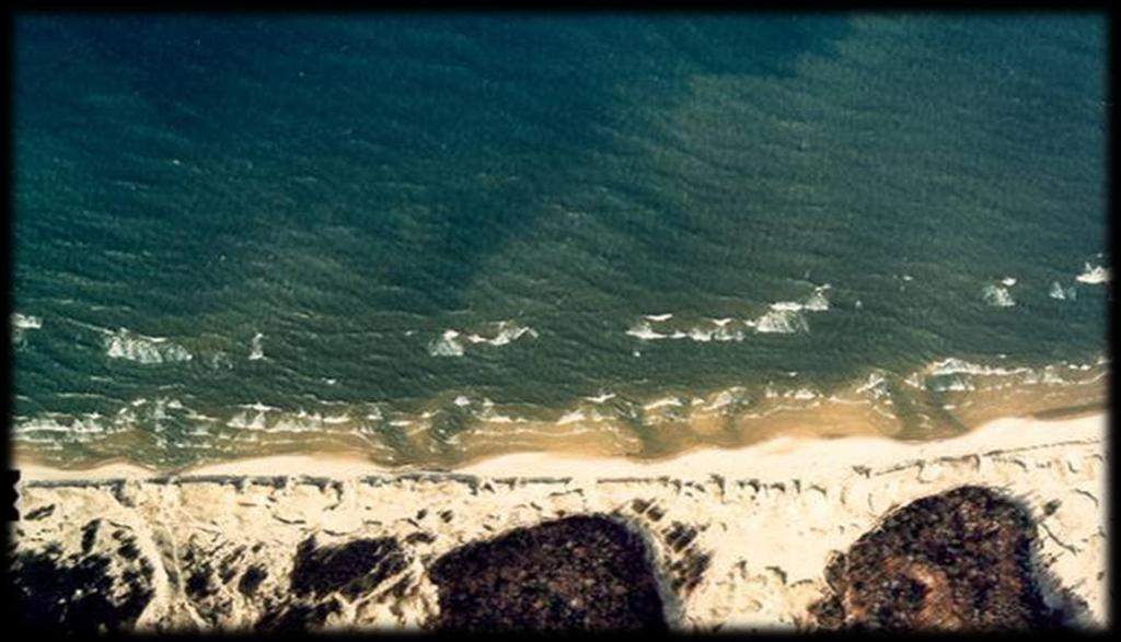
10 Once formed Rips should be expected to persist and occupy existing channels After major storms Existing bathymetry can be erased and rips begin to create new channels Time Exposure


11 Rip currents caused by a longshore variation in the build up of water in the surf zone Topographic Refraction Wave-Wave Interactions Coastal Structures Rips increase with: Increasing onshore wind Decreasing water level (tides /seiches) Rips evolve in both space and time Swell-mechanisms well-understood
12 Locally Generated Sea Mechanisms Great Lakes Storms East Coast Nor-Easters Detailed Effects of Engineering Structures How to Make Detailed Site Predictions
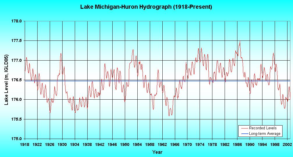
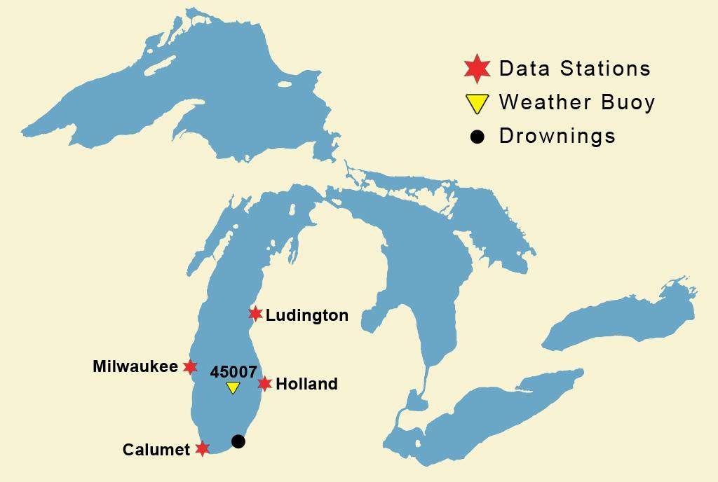
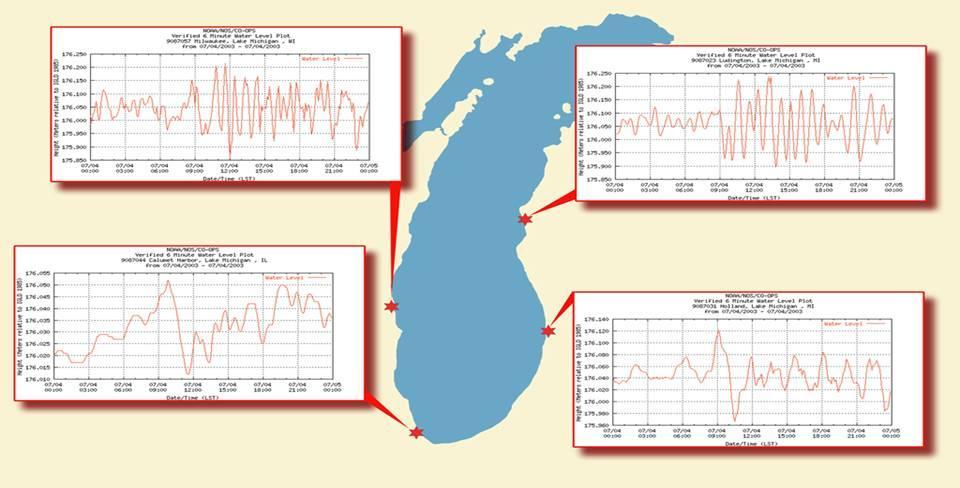
13 Seiches or Great Lakes wind tides Contributes additional water to nearshore zone Changing Water Levels Effects on nearshore slope Low water results in steeper nearshore slopes Effects on nearshore sand supply Climatological Cycles (Meadows et al., 2000) Stronger winds lead increased water levels by 18 months Sets stage for increased rip current frequency

14 Length Scale 500 km Water Depths To 400 meters Total Shoreline 17,000 kilometers

15 Primarily Locally Generated Some Long Period Swell at the Ends of the Lakes Basins are Enclosed The Great Lakes, Canada and USEPA, 1995
16 Seiches and Kelvin Waves Contribute additional water to nearshore zone Strong Air/Sea Temperature Differences Drive large and rapid wave growth Changing Water Levels Effects on nearshore bathymetry and sediment supply Climatological Cycles (Meadows et al., 2000) Stronger winds lead increased water levels by 18 months Sets stage for increased rip current frequency on low water levels.
17
18
19


20 The Great Lakes Basin

21 Long term, water levels recorded from 1860 to present Decadal Changes Seasonal Changes Daily Variations Eagle Harbor in Ephraim, WI
22
23
24
25
26
27

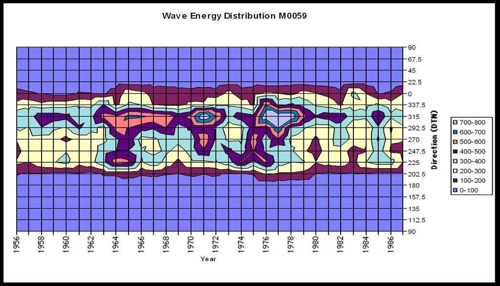
28 Time Dependent Fluctuations in Longshore Currents, Meadows, 1976 Unsteadiness in Longshore Currents, Wood and Meadows, 1975
29 Waves Well-predicted in Great Lakes In Both Space and Time Flow Magnitudes - Offshore Predictable to first order, Princeton Ocean Model Water Level Variations Seasonal, Annual and Decadal Short Term (Princeton Ocean Model)
30 East Central Florida LURCS Checklist WIND FACTORS MOST FAVORABLE FOR MOST FAVORABLE FOR RIP CURRENTS LONGSHORE CURRENTS SPEED / DIRECTION (40-110º) LURCS Procedure ( º, º) 5 kt SWELL FACTORS SWELL HEIGHT SWELL HEIGHT FACTOR 1 ft SWELL PERIOD SWELL PERIOD FACTOR 7-8 sec > MISCELLANEOUS FACTORS If astronomical tides are higher than normal (i.e., near full moon), add 0.5 If previous day Wind Factor or Swell Factor greater than or equal to 2.0/1.5, respectively, add 0.5 If RIP CURRENT THREAT is ** ( ** on weekends/major Holidays) issue statement for greater than normal threat of rip currents. If RIP CURRENT THREAT is >5.0 ** (4.0 - >5.0 ** on weekends/major Holidays) issue statement for much greater than normal threat of rip currents and/or heavy surf. Lascody, 1998
31
32 0
33

34 Research Unique Great Lakes Nearshore Dynamics Education Public Perception of Risk Conditions and Signs Outreach Coordinated with Sea Grant Extension Technology Transfer Development of Accurate and Reliable Forecasting Tools S. Briggs

35 S- Band Radar System Rip currents are difficult to capture with in situ current meters due to their episodic nature. S-Band radar is ideal for observing temporal and spatial variations in the rip current system. S-Band Radar is now available for MHL use.

36 Rip Currents are difficult to capture with in situ current meters due to their episodic nature S-Band radar is ideal for observing temporal and spatial variations in the rip current system Mobile X-band Radar Sum Imagery to Record Bathymetry 3D FFT Analysis for Currents, Wave Spectra Transportable to Remote Sites Provides Immediate Data Collection Response Courtesy of Dr. Dennis Trizna

37 Color scheme overlay on 3D mapped based on height~intensity of radar echo courtesy of Dr. Dennis Trizna
Undertow - Zonation of Flow in Broken Wave Bores
 Nearshore Circulation Undertow and Rip Cells Undertow - Zonation of Flow in Broken Wave Bores In the wave breaking process, the landward transfer of water, associated with bore and surface roller decay
Oceans in Motion: Waves and Tides
 Oceans in Motion: Waves and Tides Waves Waves are among the most familiar features in the ocean. All waves work similarly, so although we are talking about ocean waves here, the same information would
Undertow - Zonation of Flow in Broken Wave Bores
 Lecture 22 Nearshore Circulation Undertow - Zonation of Flow in Broken Wave Bores In the wave breaking process, the landward transfer of water, associated with bore and surface roller decay within the
There are many different kinds of beaches which are generally characterized by the dominance of waves, tides, rivers and currents, and in particular
 Fig. 11-11, p. 253 There are many different kinds of beaches which are generally characterized by the dominance of waves, tides, rivers and currents, and in particular differ by the amount of energy, which
OECS Regional Engineering Workshop September 29 October 3, 2014
 B E A C H E S. M A R I N A S. D E S I G N. C O N S T R U C T I O N. OECS Regional Engineering Workshop September 29 October 3, 2014 Coastal Erosion and Sea Defense: Introduction to Coastal Dynamics David
Nearshore Morphodynamics. Bars and Nearshore Bathymetry. Sediment packages parallel to shore, that store beach sediment
 Nearshore Morphodynamics http://coastal.er.usgs.gov/bier/images/chandeleur-xbeach-lg.jpg Bars and Nearshore Bathymetry Sediment packages parallel to shore, that store beach sediment Can be up to 50 km
Prediction of Nearshore Waves and Currents: Model Sensitivity, Confidence and Assimilation
 Prediction of Nearshore Waves and Currents: Model Sensitivity, Confidence and Assimilation H. Tuba Özkan-Haller College of Oceanic and Atmospheric Sciences Oregon State University, 104 Ocean Admin Bldg
Ocean Waves. Capillary. Gravity. Wind generated. Tides Tsunamis Seiches
 Ocean Waves Capillary Wind generated Gravity Tides Tsunamis Seiches Capillary waves are driven by the surface tension produced by electrically polarized water molecule San Pedro Lighthouse Waves are alternate
Swell and Wave Forecasting
 Lecture 24 Part II Swell and Wave Forecasting 29 Swell and Wave Forecasting Motivation Terminology Wave Formation Wave Decay Wave Refraction Shoaling Rouge Waves 30 Motivation In Hawaii, surf is the number
Chapter 10 Waves. wave energy NOT the water particles moves across the surface of the sea. wave form moves and with it, energy is transmitted
 Capillary Waves, Wind Waves, Chapter 10 Waves Anatomy of a Wave more like a real wave Tsunamis, Internal waves big waves huge waves rogue waves small waves more like a sine wave Wave direction Wave wave
Swell and Wave Forecasting
 Lecture 25 Swell and Wave Forecasting Swell and Wave Forecasting Motivation Terminology Wave Formation Wave Decay Wave Refraction Shoaling Rouge Waves 1 2 Motivation In Hawaii, surf is the number one weather-related
Ocean Waves and Surf Forecasting: Wave Climate and Forecasting
 Overview Ocean Waves and Surf Forecasting: Wave Climate and Forecasting Ocean regions Characterizing and describing ocean waves Wave theory, propagation, and dispersion Refraction, shadowing, and bathymetry
COASTAL ENVIRONMENTS. 454 lecture 12
 COASTAL ENVIRONMENTS Repeated movement of sediment & water constructs a beach profile reflecting the balance between average daily or seasonal wave forces and resistance of landmass to wave action Coasts
CROSS-SHORE SEDIMENT PROCESSES
 The University of the West Indies Organization of American States PROFESSIONAL DEVELOPMENT PROGRAMME: COASTAL INFRASTRUCTURE DESIGN, CONSTRUCTION AND MAINTENANCE A COURSE IN COASTAL DEFENSE SYSTEMS I CHAPTER
WIND SPEED LENGTH OF TIME WIND BLOWS (Duration) DISTANCE OVER WHICH IT BLOWS (Fetch)
 DISTANCE OVER WHICH IT BLOWS (Fetch)") WAVES Up and down movement of ocean surface Transportation of energy across the water over vast distances If not stopped by anything, waves can travel entire oceans Size and speed depend upon: WIND SPEED
WAVES Up and down movement of ocean surface Transportation of energy across the water over vast distances If not stopped by anything, waves can travel entire oceans Size and speed depend upon: WIND SPEED
Beach Wizard: Development of an Operational Nowcast, Short-Term Forecast System for Nearshore Hydrodynamics and Bathymetric Evolution
 Beach Wizard: Development of an Operational Nowcast, Short-Term Forecast System for Nearshore Hydrodynamics and Bathymetric Evolution Ad Reniers Civil Engineering and Geosciences, Delft University of Technology
Chapter 11 Tides. A tidal bore is formed when a tide arrives to an enclosed river mouth. This is a forced wave that breaks.
 Chapter 11 Tides A tidal bore is formed when a tide arrives to an enclosed river mouth. This is a forced wave that breaks. Tidal range can be very large Tide - rhythmic oscillation of the ocean surface
Waves Part II. non-dispersive (C g =C)
") Waves Part II Previously we discussed Surface Gravity Waves Deep Water Waves Shallow Water Waves C g T 2 C g h dispersive (C g =C/2) Definitions: phase speed C= /T= /k non-dispersive (C g =C) group speed
Waves Part II Previously we discussed Surface Gravity Waves Deep Water Waves Shallow Water Waves C g T 2 C g h dispersive (C g =C/2) Definitions: phase speed C= /T= /k non-dispersive (C g =C) group speed
Formulation of a Rip Current Predictive Index Using Rescue Data
 Formulation of a Rip Current Predictive Index Using Rescue Data Jason Engle*, James MacMahan, Robert J. Thieke, Daniel M Hanes and Robert G Dean *Graduate Assistant, Department of Civil and Coastal Engineering,
Appendix E Cat Island Borrow Area Analysis
 Appendix E Cat Island Borrow Area Analysis ERDC/CHL Letter Report 1 Cat Island Borrow Area Analysis Multiple borrow area configurations were considered for Cat Island restoration. Borrow area CI1 is located
Beach Profiles. Topics. Module 9b Beach Profiles and Crossshore Sediment Transport 3/23/2016. CE A676 Coastal Engineering
 Beach Profiles AND CROSS-SHORE TRANSPORT Orson P. Smith, PE, Ph.D., Professor Emeritus Topics Features of beach and nearshore profiles Equilibrium profiles Cross-shore transport References Text (Sorensen)
4/20/17. #30 - Coastlines - General Principles Coastlines - Overview
 Writing Assignment Due one week from today by 11:59 pm See main class web pages for detailed instructions Essays will be submitted in Illinois Compass (instructions later) Pick one: Earthquakes, tsunamis,
page - Laboratory Exercise #5 Shoreline Processes
 page - Laboratory Exercise #5 Shoreline Processes Section A Shoreline Processes: Overview of Waves The ocean s surface is influenced by three types of motion (waves, tides and surface currents). Shorelines
IMPROVING RIP CURRENT FORECASTING TECHNIQUES FOR THE EAST COAST OF FLORIDA
 IMPROVING RIP CURRENT FORECASTING TECHNIQUES FOR THE EAST COAST OF FLORIDA By JASON ROLLAND CUMMINS A THESIS PRESENTED TO THE GRADUATE SCHOOL OF THE UNIVERSITY OF FLORIDA IN PARTIAL FULFILLMENT OF THE
Unsteady Wave-Driven Circulation Cells Relevant to Rip Currents and Coastal Engineering
 Unsteady Wave-Driven Circulation Cells Relevant to Rip Currents and Coastal Engineering Andrew Kennedy Dept of Civil and Coastal Engineering 365 Weil Hall University of Florida Gainesville, FL 32611 phone:
Nearshore Placed Mound Physical Model Experiment
 Nearshore Placed Mound Physical Model Experiment PURPOSE: This technical note describes the migration and dispersion of a nearshore mound subjected to waves in a physical model. The summary includes recommendations
Imagine that you can see a side view of a wave as it approaches a beach. Describe how the wave changes as the wave approaches the beach.
 Geology 101 Name Reading Guide for Ch. 19: Shores and Coastal Processes (p. 612) Waves, Currents, and Tides (p. 614) Waves and Currents (p. 614) Imagine that you can see a side view of a wave as it approaches
Reading Material. Inshore oceanography, Anikouchine and Sternberg The World Ocean, Prentice-Hall
 Reading Material Inshore oceanography, Anikouchine and Sternberg The World Ocean, Prentice-Hall BEACH PROCESSES AND COASTAL ENVIRONMENTS COASTAL FEATURES Cross section Map view Terminology for Coastal
The Composition of Seawater
 The Composition of Seawater Salinity Salinity is the total amount of solid material dissolved in water. Most of the salt in seawater is sodium chloride, common table salt. Element Percent Element Percent
OCEAN WAVES NAME. I. Introduction
 NAME OCEAN WAVES I. Introduction The physical definition of a wave is a disturbance that transmits energy from one place to another. In the open ocean waves are formed when wis blowing across the water
Earth s oceans covers 71 % _ of the planet s surface. In reality, Earth s ocean waters are all. interconnected as part of a single large global ocean.
 Ocean Motion Met 101: Introduction to the World's Oceans Produced by The COMET Program Geography: Name Pd. Earth s oceans covers 71 % _ of the planet s surface. In reality, Earth s ocean waters are all
RIP CURRENTS. Award # N
 RIP CURRENTS Graham Symonds School of Geography and Oceanography University College, University of New South Wales, Australian Defence Force Academy, Canberra, 2600 AUSTRALIA Phone: 61-6-2688289 Fax: 61-6-2688313
Marginal Marine Environments
 Marginal Marine Environments Delta: discrete shoreline protuberances formed where rivers enter oceans, semi-enclosed seas, lakes or lagoons and supply sediment more rapidly than it can be redistributed
Wave research at Department of Oceanography, University of Hawai i
 Wave research at Department of Oceanography, University of Hawai i Hawaii wave climate. Directional waverider buoys around Hawaii. Past and present wave-related research projects. Effect of tides on wave
Comparison of Predicted and Measured Shoaling at Morro Bay Harbor Entrance, California
 Comparison of Predicted and Measured Shoaling at Morro Bay Harbor Entrance, California by Edward F. Thompson, Inocencio P. DiRamos, and Robert R. Bottin, Jr. PURPOSE: This Coastal and Hydraulics Engineering
Chapter - Oceans and Coasts
 Chapter - Oceans and Coasts Discussion: What do oceans contribute to the environment of Earth? How do Earth s major systems relate to the oceans? Oceans and Coasts Oceans are important - Thermal regulation
INTRODUCTION TO COASTAL ENGINEERING
 The University of the West Indies Organization of American States PROFESSIONAL DEVELOPMENT PROGRAMME: COASTAL INFRASTRUCTURE DESIGN, CONSTRUCTION AND MAINTENANCE A COURSE IN COASTAL DEFENSE SYSTEMS I CHAPTER
Name Class Date. Use the terms from the following list to complete the sentences below. Each term may be used only once. Some terms may not be used.
 Assessment Chapter Test B The Movement of Ocean Water USING KEY TERMS Use the terms from the following list to complete the sentences below. Each term may be used only once. Some terms may not be used.
Nature Of Marine winds, Waves and Swells over West African Coasts Case study of Victoria Island beach in Lagos, Nigeria
 Nature Of Marine winds, Waves and Swells over West African Coasts Case study of Victoria Island beach in Lagos, Nigeria By S. O. Gbuyiro and E. Olaniyan Marine Unit, Nigeria Meteorological Agency, Lagos
The evolution of beachrock morphology and its influence on beach morphodynamics
 The evolution of beachrock morphology and its influence on beach morphodynamics Robert J. Turner Division of Natural Sciences, Southampton College, 239 Montauk Highway, Southampton, NY 11968, U.S.A. email:
Waves. Types of Waves. Parts of a wave. Insert wind_wave.wmv. Shark attack
 Waves Recall: Waves = transmitted energy What causes waves? Wind gravity Earthquakes We will talk about all of these, but first Insert wind_wave.wmv Shark attack Types of Waves Body waves transmit energy
Concepts & Phenomena
 Concepts & Phenomena in coastal and port sedimentation R. Kamalian Ports and Maritime Organization of Iran and PIANC-Iran 7 9 December 2015 What is the problem? Many harbours have sedimentation problems
Announcements. Project 2 due Nov 7 th Topics for today: Big waves. Tsunamis, seiches and tidal waves. Tsunamis and seiches
 Announcements Project 2 due Nov 7 th Topics for today: Big waves Tsunamis, seiches and tidal waves Tsunamis and seiches Seiche: standing wave that rocks back and forth within an enclosed or semi-enclosed
MAR 110 LECTURE #15 Wave Hazards
 1 MAR 110 LECTURE #15 Wave Hazards Rogue Wave Hazard Rogue waves are very large open ocean waves of sometimes can range in height from 60 ft (20m) to120 feet (40m) and thus a significant hazard to large
Shore - place where ocean meets land Coast - refers to the larger zone affected by the processes that occur at this boundary.
 Waves, Beaches, and Coasts Shore - place where ocean meets land Coast - refers to the larger zone affected by the processes that occur at this boundary. Waves: energy moving through water The height of
The History of Coastal Flood Hazard Assessments in the Great Lakes
 The History of Coastal Flood Hazard Assessments in the Great Lakes Brian A. Caufield, P.E., CFM June 23, 2016 2 The Great Lakes Some Statistics Courtesy of Great Lakes Information Network One-fifth of
Volume and Shoreline Changes along Pinellas County Beaches during Tropical Storm Debby
 Volume and Shoreline Changes along Pinellas County Beaches during Tropical Storm Debby Ping Wang and Tiffany M. Roberts Coastal Research Laboratory University of South Florida July 24, 2012 Introduction
LAB: WHERE S THE BEACH
 Name: LAB: WHERE S THE BEACH Introduction When you build a sandcastle on the beach, you don't expect it to last forever. You spread out your towel to sunbathe, but you know you can't stay in the same spot
3/9/2013. Build house on cliff for a view of the ocean - be one with said view Pearson Education, Inc. Shorelines: summary in haiku form
 Introduction to Environmental Geology, 5e Edward A. Keller Shorelines: summary in haiku form Chapter 11 Coastal Processes Lecture Presentation prepared by X. Mara Chen, Salisbury University Build house
Coastal Wave Studies FY13 Summary Report
 DISTRIBUTION STATEMENT A. Approved for public release; distribution is unlimited. Coastal Wave Studies FY13 Summary Report Jeffrey L. Hanson US Army Corps of Engineers, Field Research Facility 1261 Duck
Waves. G. Cowles. General Physical Oceanography MAR 555. School for Marine Sciences and Technology Umass-Dartmouth
 Waves G. Cowles General Physical Oceanography MAR 555 School for Marine Sciences and Technology Umass-Dartmouth Waves Sound Waves Light Waves Surface Waves Radio Waves Tidal Waves Instrument Strings How
Beach Nourishment Impact on Beach Safety and Surfing in the North Reach of Brevard County, Florida
 Beach Nourishment Impact on Beach Safety and Surfing in the North Reach of Brevard County, Florida Prepared by John Hearin, Ph.D. Coastal Engineering Vice Chairman Cocoa Beach Chapter Port Canaveral Patrick
MAR 110 LECTURE #22 Standing Waves and Tides
 27 October 2007 MAR110_Lec22_standing Waves_tides_27oct07.doc 1 MAR 110 LECTURE #22 Standing Waves and Tides Coastal Zone Beach Profile Figure 22.1 Beach Profile Summer Onshore Sand Transport Breaking
Sandy Beach Morphodynamics. Relationship between sediment size and beach slope
 Sandy Beach Morphodynamics Relationship between sediment size and beach slope 1 Longshore Sorting - Willard Bascom Beach Slope, Grain Size, and Wave Energy Beach at Sandwich Bay, Kent, UK near the Straights
Under the Boardwalk: Coastal Geomorphology
 Under the Boardwalk: Coastal Geomorphology What to look for while you're on the beach during spring break. What Causes Changes in Sea Level? Answer Varies with Time Scale. Long-Term Changes in Sea Level
Physical Modeling of Nearshore Placed Dredged Material Rusty Permenter, Ernie Smith, Michael C. Mohr, Shanon Chader
 Physical Modeling of Nearshore Placed Dredged Material Rusty Permenter, Ernie Smith, Michael C. Mohr, Shanon Chader Research Hydraulic Engineer ERDC-Coastal Hydraulics Laboratory October 25,2012 Study
Variation in Beach Profile and Sediment Characteristics at Popham Beach, Phippsburg, ME
 Colby College Digital Commons @ Colby Undergraduate Research Symposium Student Research 2006 Variation in Beach Profile and Sediment Characteristics at Popham Beach, Phippsburg, ME Kathryn Lidington Colby
Garrett McNamara, Portugal, 30 Jan What is a wave?
 Waves Garrett McNamara, Portugal, 30 Jan 2013 What is a wave? Waves transmit a disturbance / energy from one part of a material to another. The energy is transmitted without substantial movement of the
Improving predictions of nearshore processes and shoreline dynamics for beaches along Australia s rocky and coral reef coasts
 Improving predictions of nearshore processes and shoreline dynamics for beaches along Australia s rocky and coral reef coasts Ryan Lowe Jeff Hansen, Graham Symonds, Mark Buckley, Andrew Pomeroy, Gundula
PROPAGATION OF LONG-PERIOD WAVES INTO AN ESTUARY THROUGH A NARROW INLET
 PROPAGATION OF LONG-PERIOD WAVES INTO AN ESTUARY THROUGH A NARROW INLET Takumi Okabe, Shin-ichi Aoki and Shigeru Kato Department of Civil Engineering Toyohashi University of Technology Toyohashi, Aichi,
ABSTRACT. Rip current events, as reported by lifesaving personnel along the North Carolina coast,
 ABSTRACT KENT, TIMOTHY HARTT. Analysis of Meteorological and Oceanic Conditions During Rip Current Events Along the Outer Banks of North Carolina During the 2006 and 2007 Summer Seasons. (Under the direction
Rip Currents Onshore Submarine Canyons: NCEX Analysis
 Rip Currents Onshore Submarine Canyons: NCEX Analysis Dr. Thomas C. Lippmann Civil and Environmental Engineering & Geodetic Science, Byrd Polar Research Center, 1090 Carmack Rd., Ohio State University,
A process based approach to understand WA s complex coastline Jeff Hansen Ryan Lowe Graham Symonds Laura Segura Gundula Winter
 A process based approach to understand WA s complex coastline Jeff Hansen Ryan Lowe Graham Symonds Laura Segura Gundula Winter WA s coastline is highly variable due to offshore and shore-attached coral
WAVE BREAKING AND DISSIPATION IN THE NEARSHORE
 WAVE BREAKING AND DISSIPATION IN THE NEARSHORE LONG-TERM GOALS Dr. Thomas C. Lippmann Center for Coastal Studies Scripps Institution of Oceanography University of California, San Diego 9500 Gilman Dr.
Chapter. The Dynamic Ocean
 Chapter The Dynamic Ocean An ocean current is the mass of ocean water that flows from one place to another. 16.1 The Composition of Seawater Surface Circulation Surface Currents Surface currents are movements
SURFACE CURRENTS AND TIDES
 NAME SURFACE CURRENTS AND TIDES I. Origin of surface currents Surface currents arise due to the interaction of the prevailing wis a the ocean surface. Hence the surface wi pattern (Figure 1) plays a key
Oceans and Coasts. Chapter 18
 Oceans and Coasts Chapter 18 Exploring the oceans The ocean floor Sediments thicken and the age of the seafloor increases from ridge to shore The continental shelf off the northeast United States Constituent
Chapter 11. Beach Fill and Soft Engineering Structures
 Chapter 11 Beach Fill and Soft Engineering Structures Solutions to Coastal Erosion Soft Structures Hard Structures Retreat No such thing as low cost coastal protection Beach Nourishment Beach Filling Beach
Environmental Geology Chapter 11 COASTAL PROCESSES and RELATED HAZARDS
 Environmental Geology Chapter 11 COASTAL PROCESSES and RELATED HAZARDS Introduction >50% of world population concentrated in the coastal zones ~75% of U.S. population living in coastal states Coastal hazard
Figure 1, Chart showing the location of the Breach at Old Inlet and sensors deployed in Great South Bay.
 The Impact on Great South Bay of the Breach at Old Inlet Charles N. Flagg and Roger Flood School of Marine and Atmospheric Sciences, Stony Brook University The Great South Bay project (http://po.msrc.sunysb.edu/gsb/)
Mechanisms and Characteristics of High-Speed Reef Rip Current
 Mechanisms and Characteristics of High-Speed Reef Rip Current Ryuichiro Nishi, Mario P. de Leon, Kouji Horinouchi,Akira Ohtani, Nicholas C. Kraus, and Julianti K. Manu Many people utilize beaches, but
Longshore sediment transport
 and Orson P. Smith, PE, Ph.D., Professor Emeritus Longshore transport Waves breaking at an angle to shore Sediment under breakers lifted by saltation Drops back to sea bed a little down drift Swash (runup)
PUV Wave Directional Spectra How PUV Wave Analysis Works
 PUV Wave Directional Spectra How PUV Wave Analysis Works Introduction The PUV method works by comparing velocity and pressure time series. Figure 1 shows that pressure and velocity (in the direction of
/50. Physical Geology Shorelines
 Physical Geology Shorelines Multiple Guess: (You know the drill 2 points each) 1. The path of movement of a water particle in a wave at sea is 1. circular 2. horizontal 3. vertical 4. elliptical 5. none
GEOLOGY 101 Under the Boardwalk: Coastal Geomorphology
 GEOLOGY 101 Under the Boardwalk: Coastal Geomorphology What to look for while you're on the beach during spring break. J.S. Kite, WVU What Causes Changes in Sea Level? Answer Varies with Time Scale. Long-Term
A Preliminary Review of Beach Profile and Hardbottom Interactions
 A Preliminary Review of Beach Profile and Hardbottom Interactions Douglas W. Mann, P.E., D.CE. CB&I A World of Solutions Presentation Goal Lead to a better understanding of the challenges regarding the
OCN 201 Tides. Tsunamis, Tides and other long waves
 OCN 201 Tides Tsunamis, Tides and other long waves Storm surges Caused by winds and low atmospheric pressure associated with large storms Can raise sea surface by up to 25 ft, bottom contours magnify effect
Chapter 22, Section 1 - Ocean Currents. Section Objectives
 Chapter 22, Section 1 - Ocean Currents Section Objectives Intro Surface Currents Factors Affecting Ocean Currents Global Wind Belts (you should draw and label a diagram of the global wind belts) The Coriolis
EVALUATION OF THE MODIFIED ECFL LURCS RIP CURRENT FORECASTING SCALE AND CONDITIONS OF SELECTED RIP CURRENT EVENTS IN FLORIDA
 EVALUATION OF THE MODIFIED ECFL LURCS RIP CURRENT FORECASTING SCALE AND CONDITIONS OF SELECTED RIP CURRENT EVENTS IN FLORIDA By MATTHEW SCHRADER A THESIS PRESENTED TO THE GRADUATE SCHOOL OF THE UNIVERSITY
Wave Prediction in the Santa Barbara Channel
 Wave Prediction in the Santa Barbara Channel OCS Study MMS 2001-055 Final Technical Summary Final Study Report U.S. Department of the Interior Minerals Management Service Pacific OCS Region Wave Prediction
Prof. B.S. Thandaveswara. The periodic rise and fall of the planetary ocean level in response to the gravitational
 37.5 Tides The periodic rise and fall of the planetary ocean level in response to the gravitational interaction of the earth, moon, and sun. The periodic rise and fall of sea level that results from the
What are Waves? Earthquake. Waving flags. Vocal Cords Vibrate
 Waves Ch. 10 What are Waves? All waves are movement of energy through a medium (air, rock, water) Series of vibrations or undulations in a medium Wave types: ocean, sound, light, seismic Vocal Cords Vibrate
Rip Current Rip Tide,
 Rip Current A Rip Current, sometimes called a Rip Tide, is one specific kind of water current that can be found near beaches. It is a strong, localized, narrow current of water. It is strongest near the
Deep-water orbital waves
 What happens when waves approach shore? Deep-water orbital waves Fig. 9.16, p. 211 Wave motion is influenced by water depth and shape of the shoreline wave buildup zone surf zone beach Wave base deepwater
INTRODUCTION TO COASTAL ENGINEERING AND MANAGEMENT
 Advanced Series on Ocean Engineering Volume 16 INTRODUCTION TO COASTAL ENGINEERING AND MANAGEMENT J. William Kamphuis Queen's University, Canada World Scientific Singapore New Jersey London Hong Kong Contents
An IOOS Operational Wave Observation Plan Supported by NOAA IOOS Program & USACE
 An IOOS Operational Wave Observation Plan Supported by NOAA IOOS Program & USACE R.E. Jensen, W.A. Birkemeier and W. Burnett JCOMM-Workshop on Wave Measurements from Buoys Wave Information to Application
Australian Coastal Councils Conference
 Australian Coastal Councils Conference Kiama March 2019 Where Has My Beach Gone? (and what can I do about it?) Dr Andrew McCowan Water Technology Where Has My Beach Gone? Where Has My Beach Gone? Where
Chapter 10 Lecture Outline. The Restless Oceans
 Chapter 10 Lecture Outline The Restless Oceans Focus Question 10.1 How does the Coriolis effect influence ocean currents? The Ocean s Surface Circulation Ocean currents Masses of water that flow from one
WaMoS II Wave Monitoring System
 WaMoS II Wave Monitoring System - An application of WaMoS II at Duck - Katrin Hessner, K. Reichert, J. Dannenberg OceanWaveS GmbH, Germany Kent Hathaway, Don Resio Engineering Research Development Center
TRANSPORT OF NEARSHORE DREDGE MATERIAL BERMS
 Proceedings of the 6 th International Conference on the Application of Physical Modelling in Coastal and Port Engineering and Science (Coastlab16) Ottawa, Canada, May 10-13, 2016 Copyright : Creative Commons
Earth Science Chapter 16 Section 3 Review
 Name: Class: Date: Earth Science Chapter 16 Section 3 Review Multiple Choice Identify the choice that best completes the statement or answers the question. 1. The movement of water that parallels the shore
Wave Propagation and Shoaling
 Wave Propagation and Shoaling Focus on movement and natural alteration of the characteristics of waves as they travel from the source region toward shore Waves moving from deep to intermediate/shallow
3.6 m. 7.3 m. 3.6 m. 20 m. 6 cm 1:30 1:5
 Reprinted from WAVES'97: Proceedings of the Third International Symposium on Ocean Wave Measurement and Analysis, Virginia Beach, VA { Nov. 3-7, 1997 Experimental Modeling of a Rip Current System Merrick
BEACH PROCESSES AND COASTAL ENVIRONMENTS
 BEACH PROCESSES AND COASTAL ENVIRONMENTS COASTAL FEATURES Cross section Map view TOPICS: Terminology Waves Beach Morphology Barriers Coastal Migration Tides Tidal Flats and Marshes Sediment Budgets Human
MIAMI BEACH 32ND STREET HOT SPOT: NUMERICAL MODELING AND DESIGN OPTIMIZATION. Adam Shah - Coastal Engineer Harvey Sasso P.E.
 ABSTRACT MIAMI BEACH 32ND STREET HOT SPOT: NUMERICAL MODELING AND DESIGN OPTIMIZATION Adam Shah - Coastal Engineer Harvey Sasso P.E. - Principal Coastal Systems International, Inc. 464 South Dixie Highway
FORMULATION OF A RIP CURRENT FORECASTING TECHNIQUE THROUGH STATISTICAL ANALYSIS OF RIP CURRENT-RELATED RESCUES
 FORMULATION OF A RIP CURRENT FORECASTING TECHNIQUE THROUGH STATISTICAL ANALYSIS OF RIP CURRENT-RELATED RESCUES By JASON A. ENGLE A THESIS PRESENTED TO THE GRADUATE SCHOOL OF THE UNIVERSITY OF FLORIDA IN
TITLE: COASTAL EROSION AND LANDFORMS.
 TITLE: COASTAL EROSION AND LANDFORMS. AIM: What are the factors that influence the formation of coastal features along Fishing Pond beach Trinidad? LOCATION OF FIELD STUDY: The study was carried out in
New Jersey Coastal Zone Overview. The New Jersey Beach Profile Network (NJBPN) 3 Dimensional Assessments. Quantifying Shoreline Migration
 3 Dimensional Assessments. Quantifying Shoreline Migration") New Jersey Coastal Zone Overview The New Jersey Beach Profile Network (NJBPN) Objectives Profile Locations Data Collection Analyzing NJBPN Data Examples 3 Dimensional Assessments Methodology Examples Quantifying
New Jersey Coastal Zone Overview The New Jersey Beach Profile Network (NJBPN) Objectives Profile Locations Data Collection Analyzing NJBPN Data Examples 3 Dimensional Assessments Methodology Examples Quantifying
Overview. Beach Features. Coastal Regions. Other Beach Profile Features. CHAPTER 10 The Coast: Beaches and Shoreline Processes.
 Overview CHAPTER 10 The Coast: Beaches and Shoreline Processes Coastal regions constantly change. The beach is a dominant coastal feature. Wave activity continually modifies the beach and coastal areas.
SAND BOTTOM EROSION AND CHANGES OF AN ACTIVE LAYER THICKNESS IN THE SURF ZONE OF THE NORDERNEY ISLAND
 SAND BOTTOM EROSION AND CHANGES OF AN ACTIVE LAYER THICKNESS IN THE SURF ZONE OF THE NORDERNEY ISLAND Kos'yan R. 1, Kunz H. 2, Podymov l. 3 1 Prof.Dr.,The Southern Branch of the P.P.Shirshov Institute