Absecon Island Shore Protection The planning behind the project
|
|
|
- Sibyl Long
- 5 years ago
- Views:
Transcription


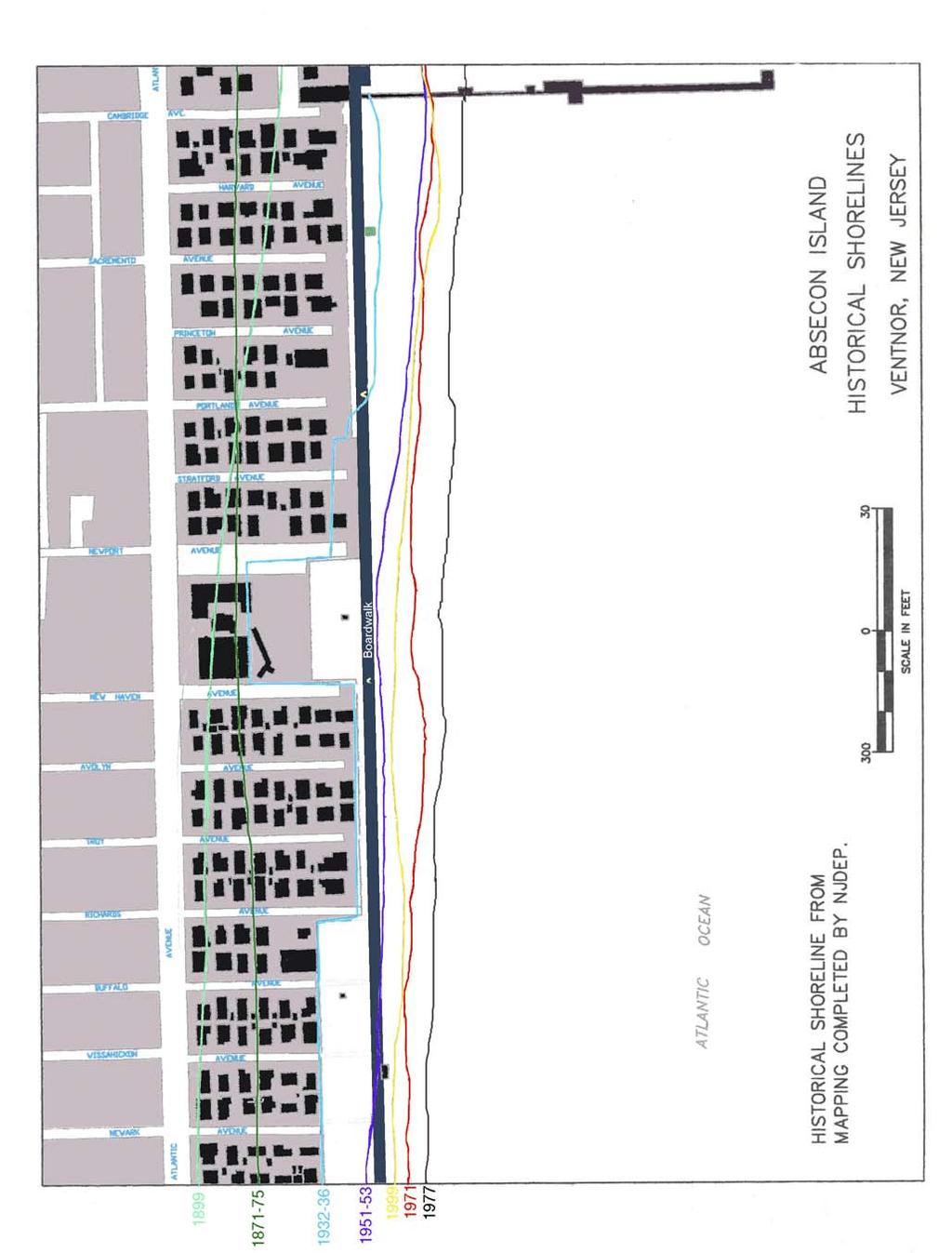
1 Absecon Island Shore Protection The planning behind the project Most residents of Atlantic City, Ventnor, Margate and Longport are now aware of upcoming plans to protect their common coastline with a beachfill and dune system that will run the length of Absecon Island. The Federal Sponsor of this project is the U.S. Army Corps of Engineers, Philadelphia District and the Non-Federal Sponsor is the State of New Jersey, Department of Environmental Protection (NJDEP). But how did these plans come about? What other alternatives were considered, and what made the U.S. Army Corps of Engineers who planned, designed and will eventually build the project choose this one? PROJECT BACKGROUND The Absecon Island Shore Protection project grew out of a larger Corps and NJDEP feasibility study that looked at ways to reduce storm damage due to flooding and wave attack and minimize shoreline erosion between Brigantine Inlet and Great Egg Harbor Inlet. Under the management of the Corps Philadelphia District, the project is now nearing completion of the design phase. Construction could begin as early as spring 2002, pending execution of a cost-sharing agreement between the Army Corps and NJDEP. For study purposes, Absecon Island was divided (or grouped) into two areas: (1) the Absecon Inlet frontage and (2) the oceanfront. The second area is the focus of this pamphlet. Absecon Island, NJ (Brigantine Inlet to Great Egg Harbor Inlet, NJ) Atlantic City Brigantine Island Absecon Inlet Bulkhead Ventnor Margate Beachfill Longport Great Egg Harbor Inlet Ocean City Brigantine Inlet Atlantic Ocean PA Philadelphia NJ Project Area MD DE Atlantic Ocean The northeast-facing orientation of Atlantic City's inlet frontage increases its vulnerability to storm damage. Extensive damage to the boardwalk, bulkheads, buildings and roads during storms in 1991 and 1992 emphasized the need to evaluate potential shore protection measures. W N S E The oceanfront of Absecon Island has historically been one of the hardest hit of all the New Jersey barrier islands during coastal storms, especially nor easters. Atlantic City has already had several large beachfills to maintain a beach along its northern end, and has had a series of groins installed to help stabilize the shoreline. The communities of Ventnor and Margate have low-elevation beaches that are prone to oceanside flooding despite the presence of bulkheads. Longport has virtually no beach in many sections of the Borough; shore protection is provided by a curved-face concrete seawall and timber bulkhead. Past bulkhead failures have resulted in significant property damage. The map on page 2 shows historical shorelines for a portion of Absecon Island. As can be seen in the figure, the 1870 s shoreline was half a block landward and consisted of naturally occurring dunes and dune grasses. After development of the area later in the century, these dunes were flattened and the beach was extended. The ocean shoreline of Absecon Island - especially in Ventnor, Margate, and Longport - has experienced relatively stable shoreline locations in comparison with the ends of the island adjacent to Absecon and Great Egg Inlets. This stability is due to the periodic placement of millions of cubic yards of sand ( beachfill, beach nourishment, etc.) onto the beach in Atlantic City over the past half-century. Along Absecon Island, the predominant transport of sand by waves is to the southwest, so that, sand initially placed in Atlantic City is naturally transported, over periods of years to decades, to the beaches of Ventnor, Margate and Longport. If sand had not been placed on Atlantic City s beach in the past, it is very likely that the other three communities on Absecon Island would have experienced more serious erosion and storm damages than they actually had over the past several decades. 1
2 2
3 PLANNING PARAMETERS Specific objectives for the Absecon Island study included the following: Reduce the impacts of long-term beach erosion along the oceanfront Improve the stability and longevity of beaches and shore protection structures in general Reduce storm flooding and wave damage along both ocean and inlet frontages Reduce maintenance of existing hardened shore protection structures (bulkheads, seawalls) along the shoreline Preserve recreational and commercial boating opportunities through Absecon and Great Egg Harbor Inlets Enhance recreational opportunities along Absecon Island Preserve, restore and maintain the environmental character of the areas affected In the evaluation of alternatives and plan selection process, economic justification is a requirement for final recommendation. The economic benefits of the project must exceed its cost. Stated differently, the benefit-to-cost ratio has to be greater than 1.0. THE PLANNING PROCESS The process of screening many alternatives to identify the best plan that is technically effective, environmentally sound and economically most beneficial consists of three stages or cycles: Stage 1. Identify various shoreline protection measures that may satisfy the problem and need. Eliminate from consideration those that obviously would not provide the minimum acceptable shore protection at a reasonable cost. Stage 2. For the remaining alternatives, evaluate shore protection benefits, construction costs and environmental impact in detail. Make a preliminary comparison between the cost of each alternative and the damages that would occur storm-induced erosion, wave attack and inundation without it. Eliminate those for which the benefits (damages prevented) do not exceed the costs. Benefits and costs are expressed on an average annual basis. Net benefits for a proposed plan are measured by subtracting average annual costs from average annual benefits. Stage 3. Develop the designs and calculate damage projections to produce the optimal plan with the greatest net benefits. Alternatives Considered (and why each one was rejected or selected) The original list of alternatives is shown below. Each method will be explained in further detail later. Nonstructural Methods: No action Evacuation from the areas subject to erosion and storm damage Regulation of future development Structural Methods: Offshore Detached Breakwater Submerged Reef Offshore Submerged Feeder Berm Beach Dewatering Lengthen the Longport Terminal Groin Seawall Beachfill with Bulkheads Beachfill with Groins Beachfill with Dunes Relocation of the Boardwalk Beachfill only Lengthen the Brigantine Jetty Realign the Absecon Inlet channel Stage 1 The alternatives listed below did not proceed to Stage No Action. In other words, maintain status quo no measures to provide erosion control, recreational beach or storm damage protection to beachfront property. WHY REJECTED: Does not meet any of the project s objectives. 2. Evacuation From Areas Subject to Erosion and Storm Damage. Permanent evacuation of existing developed areas that are prone to flooding involves not only acquiring lands and structures, but also demolishing or relocating commercial and industrial developments and residential property to another site. WHY REJECTED: The level of development in the problem areas under study would make this measure prohibitively expensive. 3. Regulation of Future Development. Regulation could be enacted to minimize the impact of erosion on lands which could be developed in the future. WHY REJECTED: Would have little impact because virtually all of the shoreline is already developed. 3


4 4. Offshore Detached Breakwaters. Typically a series of stone structures that are visible from the beach during low tide periods; an offshore detached breakwater acts as a buffer against erosion by reducing wave energy on the beaches behind it. Since a breakwater does not protect against storm surge or flooding, an initial beachfill must usually accompany it. WHY REJECTED: Because construction takes place from the water, this method would be cost prohibitive. All stone must be brought in on barges with the resulting additional difficulty of working in an open ocean environment. Would not provide sufficient protection to densely developed oceanfronts. There are also aesthetics and safety concerns. 5. Perched Beach. In combination with initial beachfill, this alternative involves the addition of an underwater structure to support the offshore end of the placed beachfill and thus eliminates the need to place additional sand to meet the ocean bottom. As a result, the actual amount of sand to be placed is less than in a typical beachfill. The underwater structure would act in the same way as a natural sandbar formed offshore during storm events. WHY REJECTED: Perched beaches are at high risk at locations with high-wave-energy such as Absecon Island. Ocean waves would scour in front of and behind the offshore structure, driving up maintenance costs; sand trapped by the perched beach will cause erosion down the coast, even if only temporarily. Since the offshore structure is submerged, it would not offer protection from storm surge; the submerged structure would also pose a safety hazard to swimmers and bathers. 6. Submerged Reef. Interlocking concrete units form an offshore reef that is designed both to reduce incident wave energy during storms and to prevent outgoing currents from carrying sand to deeper water. WHY REJECTED: This method is still in the exploratory stage and may be at high risk in the Absecon environment. Like the perched beach, this approach would not offer protection from storm surge. One installation off Avalon has had some of the erosion problems associated with the perched beach concept. 7. Offshore Submerged Feeder Berm. In some areas these nearshore berms can supply sand and reduce wave damage for about half the cost of onshore beach placement. WHY REJECTED: Experience with these berms is limited, with mixed results to date. The success of offshore submerged feeder berms is affected by such variables as wave conditions, long-term sand transport trends, and proximity to inlets of jetties. So despite their lower cost, their benefits are much less certain than traditional beachfill. 8. Beach Dewatering. This concept of draining the beach face to increase stability using onsite dewatering equipment has been tried in both Florida and Denmark. Sand in the wet beach area is typically in a buoyant state. When the groundwater is drained, the dewatered sand absorbs the sediment-laden swash, creating a deposit of new sand on the foreshore slope. WHY REJECTED: This technology is unpredictable for the Absecon environment. Erosion during a storm would likely expose and damage the dewatering equipment buried in the beach. Routine maintenance would also be required for the pump system. 9. Seawall. While it would not add any recreational beach area, construction of either a curved face seawall or a massive stone seawall would provide storm damage protection by deflecting or dissipating wave energy. WHY REJECTED: Costs of construction would be prohibitively high. Also, because seawalls protect only the land immediately behind them, widening and longterm maintenance of the adjacent beach would be necessary to reduce scour and preserve the shoreline for recreational use. Wave runup or overtopping could occur, damaging land immediately behind the seawall. 4

5 Stage 2 The alternative listed below did not proceed to Stage Extend the Longport Terminal Groin. The Corps developed a cost estimate for extending the Longport Terminal Groin marking the south end of the Absecon Island oceanfront from 500 to 1000 feet. The result showed positive net benefits because of reduced periodic nourishment requirements. WHY REJECTED: The downdrift erosion typical of groins in general has been especially pronounced for those placed at the southern end of New Jersey's barrier islands. More specifically, extending the Longport Terminal Groin seaward of the breaker zone could force sand to flow too far offshore to be returned to the Great Egg Harbor Inlet ebb shoal. That in turn would decrease the sand supply to both the Longport borrow area identified for this project and the borrow area currently being used for the Corps ongoing Ocean City beachfill project. These potential negative impacts outweigh the benefits mentioned above. SELECTING A SHORE PROTECTION PLAN Only four alternatives remained at the start of the third stage of the planning process: beachfill with bulkheads, beachfill with groins, beachfill as a standalone option, and beachfill with dunes. Since all four methods include a beachfill, the next step was to establish the required beach parameters. Beach Berm ( Towel Area ) Elevation: Based on natural berm crest elevations between +7.5 and +9.0 feet NGVD (as determined by tides, waves and beach slope), a design elevation of +8.5 feet NGVD was selected. Beachfill Slope: Based on historical profiles and the average slope of the beach berm, both onshore and offshore, a design slope of 1-to-30 was selected. Beyond that point the slope follows that of the existing profile to where the design berm meets the existing profile. Beach Berm Width: For economic evaluation, design widths ranging from 75 feet (the minimum to support a small dune) to 250 feet (beyond which the beachfill construction costs clearly increase faster than the benefits) were selected. (SEE COMPARISON OF NET BENEFITS BELOW.) Dune Heights: For economic evaluation, design heights ranging from feet (the minimum to provide significant added storm damage protection) to +18 feet NGVD were selected. Dune Shape: The dune top width for all alternatives was 25 feet except for those alternatives with a 75- foot berm width, in which case the dune top width was 15 feet. Side slopes were set at 1 vertical to 5 horizontal. Dune Alignment: In Atlantic City the proposed dune alignment follows the existing dunes. In Ventnor, Margate and Longport the proposed dunes will be as far landward on the beach berm as practical to both maximize towel area as well as provide a uniform alignment. Design Beachfill Quantities: Quantities for each alternative were calculated by comparing the proposed design cross section with existing beach survey data. Renourishment Volumes: The initial quantity of sand was intended to provide for maintenance of the design beach. Then an additional sacrificial amount was factored in to account for erosion between initial construction and the first renourishment. This way, by the end of the first renourishment cycle about three years the beach will be at its design profile. Storm Drain Outfalls: In Atlantic City, all outfalls are intact out to approximately the mean low water line; however, several of the existing outfall pipes have broken off at pipe sections located in the surf zone. Several outfalls in Ventnor, Margate and Longport have also suffered damage, and in some cases have sheared off completely at the bulkhead. Since these outfalls are now not long enough to ensure unhindered drainage for beachfill alternatives with a berm width of 200 feet or greater, the analysis included the cost of extending them. Using these parameters, the project team narrowed the options down to 14 combinations of berm widths and dune heights for the final analysis via computer modeling seven for Atlantic City and seven for the other three communities. Two alternatives were rejected at this point as stated in the following paragraphs. 5


6 11. Beachfill With Bulkhead. A bulkhead protects shoreline areas from erosion and storm damage, including flooding, but since it does not extend into the surf area, it does not reduce the flow of sand along the shoreline. Therefore beachfill would also be necessary to limit erosion in front of the bulkhead and provide additional protection. Since about 60 percent of the Absecon Island ocean frontage has existing timber or concrete bulkheads and seawalls parallel to the ocean front, this alternative examined extending the timber bulkhead walls along the entire length of the study area. This would require 12,700 feet of new bulkhead to provide a continuous line of storm protection for Atlantic City. About 1,400 feet would be needed in Ventnor, Margate and Longport primarily at street ends to replace bulkhead sections that have top elevations below +9.5 NGVD or that are in poor condition. WHY REJECTED: For Atlantic City, a simple matter of economics; the bulkhead offers little more protection than a more natural dune but costs much more. The option of raising bulkheads in Ventnor, Margate and Longport was dropped because (1) the present bulkhead system is a mix of designs and heights, making it very difficult to tie into and (2) many of the structures are on private lands, so added real estate costs would make rehabilitation too expensive. As it stands, all three communities have begun pursuing this option on their own as funding allows. 12. Beachfill With Groins. Groins are structures built perpendicular to the shoreline that extend from the upper beach face into the surf zone to trap some of the sand moving along the shoreline. When used in combination with a beachfill, a groin field can reduce both long-term erosion and the required frequency of periodic renourishment. 6 For such a system to work, an adequate quantity of sand must be moving along the shoreline and the groins must be designed properly otherwise, groin compartments at the downward end of the sand supply may not fill properly and may require periodic addition of sand. An optimally designed groin will maximize the amount of sand trapped on its updrift side closest to the sand supply while minimizing corresponding erosion of sand on its downdrift side. To supplement numerous groins already in place along the Absecon Island coastline, the Corps considered adding two groins about 1,200 feet apart in Atlantic City (southwest of the Ocean One Pier) to stabilize beachfill, and six groins in Longport that would also increase the natural beach width. WHY REJECTED: The one-time cost of groin construction turns out to be significantly higher than the cost of coming back and adding sand every three years. Also, the saw-tooth shaped profile of a groin-protected beach, together with the presence of the groins themselves, are aesthetically less pleasing to most people than an open shoreline. DETERMINATION OF BENEFITS Damages from hurricanes and coastal storms fall generally into three categories: storm-induced erosion, wave attack and inundation (flooding). Using a computer model that simulated storm events from five- to 500-year frequency, both with and without each of the alternative solutions in place, the project team was able to project monetary damages stemming from all three categories, subtracting withproject damages from without-project damages to calculate damages prevented. Both construction (initial beachfill) and long-term maintenance (renourishment) costs for each alternative were then developed and subtracted from the average yearly damages prevented to determine the net benefits. Note that the no dune options yielded negative net benefits; in other words, the damages prevented would not be enough to recover the costs of construction and maintenance.


7 COMPARISON OF NET BENEFITS Atlantic City No dune, 150-foot-wide berm $984, foot-high dune, 150-foot-wide berm +$669, foot-high dune, 200-foot-wide berm +$592, foot-high dune, 150-foot-wide berm +$832, foot-high dune, 200-foot-wide berm +$957, foot-high dune, 250-foot-wide berm +$648, foot-high dune, 200-foot-wide berm +$932,573 Ventnor, Margate and Longport No dune, 150-foot-wide berm $2,196, foot-high dune, 75-foot-wide berm +$206, foot-high dune, 100-foot-wide berm +$592, foot-high dune, 150-foot-wide berm $138, foot-high dune, 200-foot-wide berm $674, foot-high dune, 150-foot-wide berm +$296, foot-high dune, 200-foot-wide berm $272,181 FINAL PLAN FORMULATION After extensive analysis and screening, the field was narrowed down to two alternatives: beachfill only and beachfill with dunes. 13. Beachfill Only. This alternative involves the placement of sand from an offshore borrow source, directly onto the beach to widen the existing beach. Restoring the beach without sand dunes could possibly provide some storm protection by adding significantly more sand to the beach to create a much wider beach berm (the towel area or main part of the beach). However, the addition of a dune would provide a much greater level of storm protection. Sand dunes provide additional storm surge protection similar to that of bulkheads, but at much lower cost. They not only reduce flooding in low interior areas by blocking the movement of storm tides and waves into the land area behind the beach, but also serve as stockpiles to feed the beach. That is because sand accumulation on the seaward slope of a dune will either build or extend the dune toward the shoreline; this sand, once in the dune, may be returned to the beach by a severe storm. WHY SELECTED: Most cost-effective plan, meeting engineering and environmental requirements. See comparison of benefits above. HOW DUNES AND BEACHFILL WORK TOGETHER During a coastal storm, the initial wave attack is on the beach berm in front of the dune. Once the berm is eroded, waves work their way up to the dune. If no dune is in place, oceanfront structures are exposed to both wave attack and flooding. The widened beach is graded to a certain design elevation and width to provide the desired level of storm protection. After the initial widening, the beach will require additional sand on a periodic basis to keep the design beach width and elevation. WHY REJECTED: This plan was not selected because it is not cost-effective. See comparison of benefits above. 14. Beachfill With Dunes. The beach-restoration-withdune alternative provides the same beach restoration plan as described above, with additional sand placed to create a dune at a designed elevation and width. 7


8 If the attack lasts long enough, the waves can overtop the dune, lowering the dune crest. Much of the sand eroded from the berm and dune is then transported directly offshore and deposited in a bar formation. This process helps to dissipate wave energy during a storm. Offshore sand deposits are then normally transported back to the beach by waves after the storm. Onshore winds transport the sand from the beach toward the dune area, and another natural cycle of dune building proceeds. The trick is to have a dune of sufficient size so that it will not completely erode away during a major storm event. THE SELECTED PLAN The two options with the highest net benefits (one for Atlantic City and one for Ventnor/Margate/Longport) were completed to come up with the final Absecon Island shore protection plan: Beachfill With Dunes. ABSECON ISLAND SELECTED PLAN Atlantic City Ventnor/ Margate/ Longport Berm Width 200 feet 100 feet Beachfill Top Elevation +8.5 NGVD +8.5 NGVD Top Elevation +16 NGVD +14 NGVD Dune Top Width 25 feet 25 feet Side Slopes 1V:5H 1V:5H Distance from Boardwalk To aid in the visualization of dune heights: in Ventnor the dune will have an elevation 1 foot above the boardwalk, in Margate it will be 2.75 feet above the bulkhead on average and in Lonport it will be 2.5 feet above the seawall. 25 feet 25 feet Other key plan elements are as follows: The initial beachfill for the oceanfront will require over 6 million cubic yards of sand to be placed over a total shoreline length of approximately 43,000 feet, followed by periodic renourishment of about 1.7 million cubic yards every three years. The beach profile will taper from a 200-foot to 100-foot berm between Atlantic City and Ventnor over a distance of 1000 feet. Beach access will include natural beach walkover paths bordered by sand fencing up and over the dunes, and handicapped access at required intervals. These walkovers will be placed at most street ends or other traffic areas. Access for maintenance and emergency vehicles will be provided at specific locations in each community. Approximately 90 acres of dune grass will be planted and about 64,000 feet of sand fence will be erected to protect the dunes. For more information please see our web page at: or contact the Public Affairs Office, Philadelphia District, U.S. Army Corps of Engineers at (215)
Figure79. Location map for the 10 NJBPN profile sites in Atlantic County, NJ 155
 154 Figure79. Location map for the 10 NJBPN profile sites in Atlantic County, NJ 155 ATLANTIC COUNTY SPRING 2009 to FALL 2010 The Atlantic County coastline consists of three barrier islands. Between Little
23- Year Sand Volume Changes at Site 132, 15th Street, Brigantine
 149 Figure75. Location map for the 9 NJBPN profile sites in Atlantic County, NJ ATLANTIC COUNTY SPRING 2008 to FALL 2009 150 The Atlantic County oceanfront shoreline consists of three barrier islands.
New Jersey Beach Profile Network Atlantic County Profile Site Locations
 215 RICHARD STOCKTON COLLEGE OF NEW JERSEY New Jersey Beach Profile Network Atlantic County Profile Site Locations COASTAL RESEARCH CENTER Figure 128 There are nine NJBPN survey sites on the Atlantic County
ATLANTIC COUNTY 2006 to 2008
 ATLANTIC COUNTY 2006 to 2008 The Atlantic County oceanfront shoreline consists of three barrier islands where the northern one, Little Beach Island and a third of the second, Brigantine Island, are undeveloped
Atlantic Coast of Long Island, Jones Inlet to East Rockaway Inlet, Long Beach Island, NY Construction Update
 Atlantic Coast of Long Island, Jones Inlet to East Rockaway Inlet, Long Beach Island, NY Construction Update June 2016 US Army Corps of Engineers Project Purpose Three specific damage mechanisms of coastal
SPECIAL SPRING 2018 STORM REPORT ON THE CONDITION OF THE MUNICIPAL BEACHES FOR THE BOROUGH OF STONE HARBOR, CAPE MAY COUNTY, NEW JERSEY
 SPECIAL SPRING 2018 STORM REPORT ON THE CONDITION OF THE MUNICIPAL BEACHES FOR THE BOROUGH OF STONE HARBOR, CAPE MAY COUNTY, NEW JERSEY Aerial photograph taken April 21, 2018 showing the view up the beach
North Shore of Long Island, Feasibility Study
 North Shore of Long Island, Asharoken New York Asharoken, Feasibility Study Asharoken, NY Public Meeting June 30, 2015 US Army Corps of Engineers US Army Corps of Engineers New York BUILDING STRONG BUILDING
Figure 262. Location map for the 10 NJBPN profile sites in Atlantic County, NJ 279
 278 Figure 262. Location map for the 10 NJBPN profile sites in Atlantic County, NJ 279 ATLANTIC COUNTY SUMMARY The Atlantic County coastline consists of three barrier islands. The island of Little Beach
ALTERNATIVES FOR COASTAL STORM DAMAGE MITIGATION
 ALTERNATIVES FOR COASTAL STORM DAMAGE MITIGATION Dave Basco Old Dominion University, Norfolk, Virginia, USA National Park Service Photo STRUCTURAL (changes to natural, physical system) hardening (seawalls,
2013 ANNUAL REPORT - TO THE CITY OF NORTH WILDWOOD ON THE CONDITION OF THE CITY BEACHES
 2013 ANNUAL REPORT - TO THE CITY OF NORTH WILDWOOD ON THE CONDITION OF THE CITY BEACHES View on June 18, 2013 from the 2 nd Avenue jetty looking south while the 2013 beach nourishment project was under
ALTERNATIVES FOR COASTAL STORM DAMAGE MITIGATION AND FUNCTIONAL DESIGN OF COASTAL STRUCTURES
 The University of the West Indies Organization of American States PROFESSIONAL DEVELOPMENT PROGRAMME: COASTAL INFRASTRUCTURE DESIGN, CONSTRUCTION AND MAINTENANCE A COURSE IN COASTAL DEFENSE SYSTEMS I CHAPTER
A REVIEW OF THE CONDITION OF THE MUNICIPAL BEACHES AS A RESULT OF HURRICANE SANDY IN THE BOROUGH OF STONE HARBOR, CAPE MAY COUNTY, NEW JERSEY
 A REVIEW OF THE CONDITION OF THE MUNICIPAL BEACHES AS A RESULT OF HURRICANE SANDY IN THE BOROUGH OF STONE HARBOR, CAPE MAY COUNTY, NEW JERSEY View along the dune scarp from 103 rd Street on October 31,
ATLANTIC COAST OF LONG ISLAND, JONES INLET TO EAST ROCKAWAY INLET, LONG BEACH ISLAND, NY. Contract #2 Construction Scope. April 18th-19th 2018
 ATLANTIC COAST OF LONG ISLAND, JONES INLET TO EAST ROCKAWAY INLET, LONG BEACH ISLAND, NY Contract #2 Construction Scope April 18th-19th 2018 New York District PLAN COMPONENTS Length of Beachfill 35,000
UPPER BEACH REPLENISHMENT PROJECT RELATED
 ASSESSMENT OF SAND VOLUME LOSS at the TOWNSHIP of UPPER BEACH REPLENISHMENT PROJECT RELATED to the LANDFALL OF HURRICANE SANDY - PURSUANT TO NJ-DR 4086 This assessment is in response to Hurricane Sandy
LAB: WHERE S THE BEACH
 Name: LAB: WHERE S THE BEACH Introduction When you build a sandcastle on the beach, you don't expect it to last forever. You spread out your towel to sunbathe, but you know you can't stay in the same spot
Volume and Shoreline Changes along Pinellas County Beaches during Tropical Storm Debby
 Volume and Shoreline Changes along Pinellas County Beaches during Tropical Storm Debby Ping Wang and Tiffany M. Roberts Coastal Research Laboratory University of South Florida July 24, 2012 Introduction
New Jersey Coastal Zone Overview. The New Jersey Beach Profile Network (NJBPN) 3 Dimensional Assessments. Quantifying Shoreline Migration
 3 Dimensional Assessments. Quantifying Shoreline Migration") New Jersey Coastal Zone Overview The New Jersey Beach Profile Network (NJBPN) Objectives Profile Locations Data Collection Analyzing NJBPN Data Examples 3 Dimensional Assessments Methodology Examples Quantifying
New Jersey Coastal Zone Overview The New Jersey Beach Profile Network (NJBPN) Objectives Profile Locations Data Collection Analyzing NJBPN Data Examples 3 Dimensional Assessments Methodology Examples Quantifying
RE: Hurricane Matthew Beach Damage Assessment and Recommendations [CSE 2416]
![RE: Hurricane Matthew Beach Damage Assessment and Recommendations [CSE 2416]](/thumbs/83/87675702.jpg "RE: Hurricane Matthew Beach Damage Assessment and Recommendations [CSE 2416]") October 25, 2016 Iris Hill Town Administrator Town of Edisto Beach 2414 Murray St Edisto Beach SC 29438 RE: Hurricane Matthew Beach Damage Assessment and Recommendations [CSE 2416] Dear Iris, Hurricane
October 25, 2016 Iris Hill Town Administrator Town of Edisto Beach 2414 Murray St Edisto Beach SC 29438 RE: Hurricane Matthew Beach Damage Assessment and Recommendations [CSE 2416] Dear Iris, Hurricane
Building Coastal Resiliency at Plymouth Long Beach
 Building Coastal Resiliency at Plymouth Long Beach Department of Marine and Environmental Affairs March 30, 2017 Introducing Green Infrastructure for Coastal Resiliency Plymouth Long Beach & Warren s Cove
Delaware Chapter Surfrider Foundation - Indian River Inlet Monitoring
 Delaware Chapter Surfrider Foundation - Indian River Inlet Monitoring In 2012, the Delaware Surfrider Foundation Chapter formed the Surf Quality and Access Committee to focus on issues such as surf spot
2015 ANNUAL REPORT - TO THE CITY OF NORTH WILDWOOD ON THE CONDITION OF THE CITY BEACHES
 2015 ANNUAL REPORT - TO THE CITY OF NORTH WILDWOOD ON THE CONDITION OF THE CITY BEACHES Ariel view of North Wildwood looking south from the Hereford Inlet perspective on June 24, 2015. The main channel
Controlling Coastal erosion
 Controlling Coastal erosion Coastal Erosion Rates in the U.S. Coastal Erosion and Stabilization Economic pressures demanding the stabilization of beaches and coastlines are immense Coastal Erosion and
2018 Beach Preservation Project Information
 QUICK FACTS Beach Renourishment to begin late April 2018 o U.S. Army Corps of Engineers project o Project Area: 8 th St. E. to end of E. Ashley Ave. o Project Length: 2 miles o Cost: $10,900,000 o Funding:
2014 ANNUAL REPORT - TO THE CITY OF NORTH WILDWOOD ON THE CONDITION OF THE CITY BEACHES
 2014 ANNUAL REPORT - TO THE CITY OF NORTH WILDWOOD ON THE CONDITION OF THE CITY BEACHES View on September 25, 2014 looking northwest into Hereford Inlet. Considerable southerly expansion of the tip of
FINDING OF NO SIGNIFICANT IMPACT
 DEPARTMENT OF THE ARMY CHARLESTON DISTRICT, CORPS OF ENGINEERS 69A HAGOOD AVENUE CHARLESTON, SOUTH CAROLINA 29403-5107 FINDING OF NO SIGNIFICANT IMPACT EDISTO BEACH COASTAL STORM DAMAGE REDUCTION GENERAL
Figure 106. Locations of the 28 NJBPN profile stations in Ocean County, NJ.
 130 Figure 106. Locations of the 28 NJBPN profile stations in Ocean County, NJ. 131 2016-2017 Beach Fills in Ocean County: The federal/state/local storm damage reduction project (beachfill) between Manasquan
FINAL REPORT FOR 2013 ON THE CONDITION OF THE MUNICIPAL BEACHES IN THE TOWNSHIP OF UPPER, CAPE MAY COUNTY, NEW JERSEY
 FINAL REPORT FOR 2013 ON THE CONDITION OF THE MUNICIPAL BEACHES IN THE TOWNSHIP OF UPPER, CAPE MAY COUNTY, NEW JERSEY Aerial photograph at Corson s Inlet showing conditions on December 1, 2013 of the north
FINAL REPORT FOR 2013 ON THE CONDITION OF THE MUNICIPAL OCEANFRONT BEACHES THE BOROUGH OF AVALON, CAPE MAY COUNTY, NEW JERSEY
 FINAL REPORT FOR 2013 ON THE CONDITION OF THE MUNICIPAL OCEANFRONT BEACHES THE BOROUGH OF AVALON, CAPE MAY COUNTY, NEW JERSEY View from 12 th Street to the south taken February 28, 2013, following completion
OECS Regional Engineering Workshop September 29 October 3, 2014
 B E A C H E S. M A R I N A S. D E S I G N. C O N S T R U C T I O N. OECS Regional Engineering Workshop September 29 October 3, 2014 Coastal Erosion and Sea Defense: Introduction to Coastal/Marine Structures
Figure 38. Locations of the 28 NJBPN profile stations in Ocean County, NJ.
 55 Figure 38. Locations of the 28 NJBPN profile stations in Ocean County, NJ. 56 Individual Site Descriptions: Northern Ocean County recovered its beaches approaching pre-hurricane Sandy elevation or width,
Nearshore Sediment Transport What influences the loss of sediment on Beaches? - Waves - Winds - Tidal Currents - River discharge - Runoff
 Tides & Beaches Nearshore Sediment Transport What influences the loss of sediment on Beaches? - Waves - Winds - Tidal Currents - River discharge - Runoff Oceans Ocean Topography Physical Structure of the
Beach Nourishment Impact on Beach Safety and Surfing in the North Reach of Brevard County, Florida
 Beach Nourishment Impact on Beach Safety and Surfing in the North Reach of Brevard County, Florida Prepared by John Hearin, Ph.D. Coastal Engineering Vice Chairman Cocoa Beach Chapter Port Canaveral Patrick
DUNE STABILIZATION AND BEACH EROSION
 DUNE STABILIZATION AND BEACH EROSION CAPE HATTERAS NATIONAL SEASHORE NORTH CAROLINA ROBERT DOLAN PAUL GODFREY U. S. DEPARTMENT OF INTERIOR NATIONAL PARK SERVICE OFFICE OF NATURAL SCIENCE WASHINGTON, D.
SACO RIVER AND CAMP ELLIS BEACH SACO, MAINE SECTION 111 SHORE DAMAGE MITIGATION PROJECT APPENDIX F ECONOMIC ASSESSMENT
 SACO RIVER AND CAMP ELLIS BEACH SACO, MAINE SECTION 111 SHORE DAMAGE MITIGATION PROJECT APPENDIX F ECONOMIC ASSESSMENT Department of the Army New England District, Corps of Engineers 696 Virginia Road
ST. LUCIE COUNTY, FLORIDA
 ST. LUCIE COUNTY, FLORIDA COASTAL STORM RISK MANAGEMENT STUDY Draft Feasibility Study & Integrated Environmental Assessment Public Meeting Presented by U.S. Army Corps of Engineers Jacksonville District
Overview. Beach Features. Coastal Regions. Other Beach Profile Features. CHAPTER 10 The Coast: Beaches and Shoreline Processes.
 Overview CHAPTER 10 The Coast: Beaches and Shoreline Processes Coastal regions constantly change. The beach is a dominant coastal feature. Wave activity continually modifies the beach and coastal areas.
4/20/17. #32 - Coastal Erosion Case Histories - Lake Michigan
 Writing Assignment Due Monday by 11:59 pm #32 - Coastal Erosion Case Histories - Lake Michigan See main class web pages for detailed instructions Submit papers Illinois Compass No copying: Compass will
Reading Material. Inshore oceanography, Anikouchine and Sternberg The World Ocean, Prentice-Hall
 Reading Material Inshore oceanography, Anikouchine and Sternberg The World Ocean, Prentice-Hall BEACH PROCESSES AND COASTAL ENVIRONMENTS COASTAL FEATURES Cross section Map view Terminology for Coastal
Oceans and Coasts. Chapter 18
 Oceans and Coasts Chapter 18 Exploring the oceans The ocean floor Sediments thicken and the age of the seafloor increases from ridge to shore The continental shelf off the northeast United States Constituent
FINAL REPORT FOR 2009 ON THE CONDITION OF THE MUNICIPAL OCEANFRONT BEACHES IN THE BOROUGH OF AVALON, CAPE MAY COUNTY, NEW JERSEY
 FINAL REPORT FOR 2009 ON THE CONDITION OF THE MUNICIPAL OCEANFRONT BEACHES IN THE BOROUGH OF AVALON, CAPE MAY COUNTY, NEW JERSEY Storm waves pound the inlet revetment September 10, 2009 as the series of
Figure 46. Locations of the 28 NJBPN profile stations in Ocean County, NJ. A new site was added in the Borough of Seaside Heights (#248).
.") 90 Figure 46. Locations of the 28 NJBPN profile stations in Ocean County, NJ. A new site was added in the Borough of Seaside Heights (#248). 91 OCEAN COUNTY SPRING 2008 to FALL 2009 The Ocean County shoreline
90 Figure 46. Locations of the 28 NJBPN profile stations in Ocean County, NJ. A new site was added in the Borough of Seaside Heights (#248). 91 OCEAN COUNTY SPRING 2008 to FALL 2009 The Ocean County shoreline
4/20/17. #31 - Coastal Erosion. Coastal Erosion - Overview
 Writing Assignment Due Monday by 11:59 pm #31 - Coastal Erosion Beach front property! Great View! Buy now at a great price! See main class web pages for detailed instructions Essays will be submitted in
ST. JOSEPH PENINSULA, GULF COUNTY, FLORIDA Beach Re-Nourishment and Environmental Enhancement Project RECOMMENDATIONS
 ST. JOSEPH PENINSULA, GULF COUNTY, FLORIDA Beach Re-Nourishment and Environmental Enhancement Project RECOMMENDATIONS January 23, 2018 543 Harbor Boulevard, Suite 204 Destin, Florida 32541 850.654.1555
Protecting our Beaches
 Protecting our Beaches South Amelia Island Shore Stabilization Project Nassau County, FL Mr. Drew Wallace President South Amelia Island Shore Stabilization Association (SAISSA) Mr. Bill Moore, AICP Project
The Sand Beaches of New Hampshire and Maine
 The Sand Beaches of New Hampshire and Maine Beach Preservation and Erosion Control Photographs provided by Joe Kelly and Steve Adams Cover photo: Reid State Park, ME Introduction The sand beaches of New
CHAPTER 281 INFLUENCE OF NEARSHORE HARDBOTTOM ON REGIONAL SEDIMENT TRANSPORT
 CHAPTER 281 INFLUENCE OF NEARSHORE HARDBOTTOM ON REGIONAL SEDIMENT TRANSPORT Paul C.-P. Lin, Ph.D., P.E. 1 and R. Harvey Sasso, P.E. 2 ABSTRACT The influence of nearshore hardbottom on longshore and cross-shore
FINAL REPORT FOR 2011 ON THE CONDITION OF THE MUNICIPAL BEACHES IN THE CITY OF BRIGANTINE BEACH, ATLANTIC COUNTY, NEW JERSEY
 FINAL REPORT FOR 2011 ON THE CONDITION OF THE MUNICIPAL BEACHES IN THE CITY OF BRIGANTINE BEACH, ATLANTIC COUNTY, NEW JERSEY Photograph was taken October 10, 2011 from 10 th Street North looking south
Shorelines Earth - Chapter 20 Stan Hatfield Southwestern Illinois College
 Shorelines Earth - Chapter 20 Stan Hatfield Southwestern Illinois College The Shoreline A Dynamic Interface The shoreline is a dynamic interface (common boundary) among air, land, and the ocean. The shoreline
HURRICANE SANDY LIMITED REEVALUATION REPORT UNION BEACH, NEW JERSEY DRAFT ENGINEERING APPENDIX SUB APPENDIX D SBEACH MODELING
 HURRICANE SANDY LIMITED REEVALUATION REPORT UNION BEACH, NEW JERSEY DRAFT ENGINEERING APPENDIX SUB APPENDIX D SBEACH MODELING Rev. 18 Feb 2015 1 SBEACH Modeling 1.0 Introduction Following the methodology
Beach, dune and development in the Borough of Mantoloking as of January Prepared for The Borough of Mantoloking: April 2, 2008
 Summary of 20-years of Shoreline Monitoring Between Maryland Avenue, Point Pleasant Beach, Bay Head, Mantoloking, Brick Township, to 1 st Avenue in Normandy Beach, Ocean County, New Jersey & an Evaluation
Long Beach Island Holgate Spit Little Egg Inlet Historical Evolution Introduction Longshore Transport Map, Survey and Photo Historic Sequence
 Appendix B Long Beach Island Holgate Spit Little Egg Inlet Historical Evolution Introduction The undeveloped southern end of Long Beach Island (LBI) is referred to as the Holgate spit as it adjoins the
Beach Dune Performance Assessment of. New Jersey Beach Profile Network (NJBPN) Sites at. Long Beach Island, New Jersey. After Hurricane Sandy
 Sites at. Long Beach Island, New Jersey. After Hurricane Sandy") Beach Dune Performance Assessment of New Jersey Beach Profile Network (NJBPN) Sites at Long Beach Island, New Jersey After Hurricane Sandy November 13, 2012 The Richard Stockton College of NJ Coastal Research
Beach Dune Performance Assessment of New Jersey Beach Profile Network (NJBPN) Sites at Long Beach Island, New Jersey After Hurricane Sandy November 13, 2012 The Richard Stockton College of NJ Coastal Research
Recycling of Surplus Sand to Extend the Time Between Beach Fill Episodes
 Recycling of Surplus Sand to Extend the Time Between Beach Fill Episodes Cape May County, New Jersey Dr. Stewart Farrell Coastal Research Center 1795 Franklin Map Shows Inlets Inlet Morphology has Remained
Table 4. Volumetric Change Rates Pre-Project and Post-Project for the Town of Duck
 V. VOLUMETRIC CHANGES General Volumetric changes measured over the entire monitoring area for various time periods are provided in Table 4. The volume changes are given in terms of cubic yards/foot of
Inlet Management Study for Pass-A-Grille and Bunces Pass, Pinellas County, Florida
 Inlet Management Study for Pass-A-Grille and Bunces Pass, Pinellas County, Florida Final Report Submitted By Ping Wang, Ph.D., Jun Cheng Ph.D., Zachary Westfall, and Mathieu Vallee Coastal Research Laboratory
Chapter 10 Lecture Outline. The Restless Oceans
 Chapter 10 Lecture Outline The Restless Oceans Focus Question 10.1 How does the Coriolis effect influence ocean currents? The Ocean s Surface Circulation Ocean currents Masses of water that flow from one
STATUS REPORT FOR THE SUBMERGED REEF BALL TM ARTIFICIAL REEF SUBMERGED BREAKWATER BEACH STABILIZATION PROJECT FOR THE GRAND CAYMAN MARRIOTT HOTEL
 August 23 STATUS REPORT FOR THE SUBMERGED REEF BALL TM ARTIFICIAL REEF SUBMERGED BREAKWATER BEACH STABILIZATION PROJECT FOR THE GRAND CAYMAN MARRIOTT HOTEL performed by Lee E. Harris, Ph.D., P.E. Consulting
Deep-water orbital waves
 What happens when waves approach shore? Deep-water orbital waves Fig. 9.16, p. 211 Wave motion is influenced by water depth and shape of the shoreline wave buildup zone surf zone beach Wave base deepwater
FINAL ENVIRONMENTAL IMPACT STATEMENT ON BROWARD COUNTY SHORE PROTECTION PROJECT SEGMENTS II AND III BROWARD COUNTY, FLORIDA
 FINAL ENVIRONMENTAL IMPACT STATEMENT ON BROWARD COUNTY SHORE PROTECTION PROJECT SEGMENTS II AND III BROWARD COUNTY, FLORIDA 1. PROJECT PURPOSE AND NEED 1.1. PROJECT AUTHORITY. 1.1.1. INITIAL AUTHORIZATION.
FINAL REPORT FOR 2012 ON THE CHANGES SEEN ON THE OCEANFRONT BEACHES
 FINAL REPORT FOR 2012 ON THE CHANGES SEEN ON THE OCEANFRONT BEACHES IN THE BOROUGH OF MANTOLOKING, OCEAN COUNTY, NEW JERSEY FOCUSED ON THE IMPACTS OF HURRICANE SANDY View looking north on Route 5 on October
KEYNOTE PRESENTATION FSBPA olsen
 AMELIA ISAND, FLORIDA BEACH MANAGEMENT PARTNERING AND PERSERVERENCE Erik Olsen, PE associates, inc. KEYNOTE PRESENTATION FSBPA 2009 IN ORDER TO ADDRESS SHORE PROTECTION TODAY LOCAL INTERESTS PARTNER WITH:
Impact of Hurricane Matthew on the Atlantic Coast of Florida
 Impact of Hurricane Matthew on the Atlantic Coast of Florida A coastal engineer was driving across country and his jeep broke down in front of a monastery. It was late in the day and the monks invited
Performance of Upham Beach T-Groin Project and Its Impact to the Downdrift Beach
 Performance of Upham Beach T-Groin Project and Its Impact to the Downdrift Beach Progress Report for the Period of October 2008 to April 2009 Submitted by Ping Wang, Ph.D., and Tiffany M. Roberts Department
The Dynamic Coast. Right Place Resources. A presentation about the interaction between the dynamic coast and people
 The Dynamic Coast Houses threatened by coastal erosion in California Right Place Resources A presentation about the interaction between the dynamic coast and people For the rest of the presentations in
Assateague Island National Seashore North End Restoration Project Timeline
 Assateague Island National Seashore North End Restoration Project Timeline Date Event Some information provided in the Project Introduction document. Detailed events are available in a timeline compiled
Estuarine Shoreline Stabilization
 Estuarine Shoreline Stabilization Property Owner s Guide to Determining the Most Appropriate Stabilization Method Estuarine shorelines are dynamic features that experience continued erosion. Land is lost
Lecture Outlines PowerPoint. Chapter 15 Earth Science, 12e Tarbuck/Lutgens
 Lecture Outlines PowerPoint Chapter 15 Earth Science, 12e Tarbuck/Lutgens 2009 Pearson Prentice Hall This work is protected by United States copyright laws and is provided solely for the use of instructors
OCEAN COUNTY 2006 to 2008
 OCEAN COUNTY 2006 to 2008 Ocean County finally started to benefit from long-awaited startup of Federal beach nourishment projects when sand was pumped onto Surf City, Long Beach Island in late 2006. This
Chapter 20 Lecture. Earth: An Introduction to Physical Geology. Eleventh Edition. Shorelines. Tarbuck and Lutgens Pearson Education, Inc.
 Chapter 20 Lecture Earth: An Introduction to Physical Geology Eleventh Edition Shorelines Tarbuck and Lutgens The Shoreline: A Dynamic Interface The Coastal Zone The shoreline is constantly modified by
Essentials of Oceanography Eleventh Edition
 Chapter Chapter 1 10 Clickers Lecture Essentials of Oceanography Eleventh Edition The Coast: Beaches and Shoreline Processes Alan P. Trujillo Harold V. Thurman Chapter Overview Coastal regions have distinct
Figure 41. Locations of the 28 NJBPN profile stations in Ocean County, NJ.
 57 Figure 41. Locations of the 28 NJBPN profile stations in Ocean County, NJ. 58 Hurricane Sandy s Impact on the Ocean County Shoreline; In general terms, all forms of damage to beaches, dunes and public
Figure 38. Locations of the 28 NJBPN profile stations in Ocean County, NJ.
 52 Figure 38. Locations of the 28 NJBPN profile stations in Ocean County, NJ. 53 Individual Site Descriptions: Beaches in Northern Ocean County continued to recover slowly as sand transported offshore
New Jersey Beach Profile Network Ocean County Profile Site Locations
 125 RICHARD STOCKTON COLLEGE OF NEW JERSEY COASTAL RESEARCH CENTER New Jersey Beach Profile Network Ocean County Profile Site Locations Figure 73 156 155 154 153 152 151 15 149 The Ocean County shoreline
PREPARED FOR: THE BOROUGH OF AVALON 3100 DUNE DRIVE AVALON, NJ 08202
 FINAL REPORT FOR 2012 ON THE CONDITION OF THE MUNICIPAL OCEANFRONT BEACHES FOLLOWING HURRICANE SANDY IN THE BOROUGH OF AVALON, CAPE MAY COUNTY, NEW JERSEY View from 78 th Street to the north immediately
EVALUATION OF BEACH EROSION UP-DRIFT OF TIDAL INLETS IN SOUTHWEST AND CENTRAL FLORIDA, USA. Mohamed A. Dabees 1 and Brett D.
 EVALUATION OF BEACH EROSION UP-DRIFT OF TIDAL INLETS IN SOUTHWEST AND CENTRAL FLORIDA, USA Mohamed A. Dabees 1 and Brett D. Moore 1 The paper discusses the analysis of up-drift beach erosion near selected
Beach Renourishment in Jacksonville
 Beach Renourishment in Jacksonville Kevin Bodge, PhD, P.E. - Olsen Associates, Inc. 1978 Oct 2004 2000 2016 2011 Oct 2016 Coastal Duval County, FL Nassau Sound Blount Island Ft. George Inlet St. Johns
IMPACTS OF COASTAL PROTECTION STRATEGIES ON THE COASTS OF CRETE: NUMERICAL EXPERIMENTS
 IMPACTS OF COASTAL PROTECTION STRATEGIES ON THE COASTS OF CRETE: NUMERICAL EXPERIMENTS Tsanis, I.K., Saied, U.M., Valavanis V. Department of Environmental Engineering, Technical University of Crete, Chania,
MOREHEAD CITY HARBOR, NC. Dredged Material Management Plan (DMMP)
") MOREHEAD CITY HARBOR, NC Dredged Material Management Plan (DMMP) Public Meeting/Info Session 15 January 2014 US Army Corps of Engineers Morehead City Harbor DMMP Presentation Topics Morehead City Harbor
MOREHEAD CITY HARBOR, NC Dredged Material Management Plan (DMMP) Public Meeting/Info Session 15 January 2014 US Army Corps of Engineers Morehead City Harbor DMMP Presentation Topics Morehead City Harbor
6/19/2006 The Reef Ball Foundation 1
 6/19/2006 The Reef Ball Foundation 1 Overview Reef Balls are prefabricated concrete modules used as a base for natural coral reefs to form. Reef Balls have been used in 55 countries in over 3,500 projects
Chapter 15 SEASONAL CHANGES IN BEACHES OP THE NORTH ATLANTIC COAST OF THE UNITED STATES
 Chapter 15 SEASONAL CHANGES IN BEACHES OP THE NORTH ATLANTIC COAST OF THE UNITED STATES By John M. Darling Hydraulic Engineer, Research Division U. S. Army Coastal Engineering Research Center Corps of
USE OF SEGMENTED OFFSHORE BREAKWATERS FOR BEACH EROSION CONTROL
 .. CETN-III-22 4/84 PURPOSE: USE OF SEGMENTED OFFSHORE BREAKWATERS FOR BEACH EROSION CONTROL To provide information on the functional application of and general design considerations for using offshore
Long Term Success and Future Approach of the Captiva and Sanibel Islands Beach Renourishment Program
 2017 National Conference on Beach Preservation Technology February 8-10, 2017; Stuart, Florida Long Term Success and Future Approach of the Captiva and Sanibel Islands Beach Renourishment Program Thomas
US Beach Nourishment Experience:
 Beach Nourishment: Introduction of new sand to the beach by truck or dredge Large beach >1 million cubic yards (100,000 dump truck loads) Funding is a combination of federal, state, local & private Also
HARBOUR SEDIMENTATION - COMPARISON WITH MODEL
 HARBOUR SEDIMENTATION - COMPARISON WITH MODEL ABSTRACT A mobile-bed model study of Pointe Sapin Harbour, in the Gulf of St. Lawrence, resulted in construction of a detached breakwater and sand trap to
The Stockton University Coastal
 Hurricane Sandy: Beach-dune recovery at New Jersey Beach Profile Network (NJBPN) sites By Kimberly K. McKenna 1, Stewart C. Farrell 1, and Jeffrey A. Gebert 2 1 Stockton University Coastal Research Center
Evaluating a Prefabricated Submerged Breakwater and Double-T Sill for Beach Erosion Prevention, Cape May Point, NJ ABSTRACT
 Evaluating a Prefabricated Submerged Breakwater and Double-T Sill for Beach Erosion Prevention, Cape May Point, NJ Donald K. Stauble 1 and Michael A. Giovannozzi 2 ABSTRACT As part of the US Army Corps
page - Laboratory Exercise #5 Shoreline Processes
 page - Laboratory Exercise #5 Shoreline Processes Section A Shoreline Processes: Overview of Waves The ocean s surface is influenced by three types of motion (waves, tides and surface currents). Shorelines
Earth Science Chapter 16 Section 3 Review
 Name: Class: Date: Earth Science Chapter 16 Section 3 Review Multiple Choice Identify the choice that best completes the statement or answers the question. 1. The movement of water that parallels the shore
Fact Sheet Ordinance Regulating Erosion Threatened Structures
 Fact Sheet Ordinance Regulating Erosion Threatened Structures Town of Duck, North Carolina August 15, 2011 What is being considered? The Town of Duck Council is considering an ordinance to limit the encroachment
TABLE OF CONTENTS APPENDIX & BIBLIOGRAPHY
 TABLE OF CONTENTS Executive Summary 1 Acknowledgements 3 Introduction 3 The New Jersey Coastal Zone 3 Storm Recovery and Beach Project Effectiveness 3 Monmouth County 4 Figure 1. Monmouth County Station
Sediment Transport Analysis Village of Asharoken, New York
 Sediment Transport Analysis Village of Asharoken, New York NORTH SHORE OF LONG ISLAND, NEW YORK COMBINED EROSION CONTROL AND STORM DAMAGE PROTECTION FEASIBILITY STUDY FINAL REPORT August 2004 Cell 0 Asharoken
DELAWARE S VULNERABLE COASTAL AREAS. DELAWARE INLAND BAYS and DELAWARE BAY RECONNAISSANCE STUDY
 DELAWARE S VULNERABLE COASTAL AREAS and the DELAWARE INLAND BAYS and DELAWARE BAY RECONNAISSANCE STUDY Kimberly K. McKenna, PG Delaware Dept. of Natural Resources & Environmental Control Division of Watershed
Dare County Nourishment Project Town of Duck
 Dare County Nourishment Project Town of Duck Julien Devisse, P.E. and Ken Willson CB&I / Coastal Planning & Engineering of North Carolina, Inc. February 15, 2017 A World of Solutions Outline Background
Chapter 11. Beach Fill and Soft Engineering Structures
 Chapter 11 Beach Fill and Soft Engineering Structures Solutions to Coastal Erosion Soft Structures Hard Structures Retreat No such thing as low cost coastal protection Beach Nourishment Beach Filling Beach
Dear Mr. Howard Ruben,
 Mr. Howard Ruben ( Howard.Ruben@usace.army.mil) The U.S. Army Corps of Engineers New York District Planning Division-Environmental Branch 26 Federal Plaza New York, New York 10278-0090 Dear Mr. Howard
Figure 4, Photo mosaic taken on February 14 about an hour before sunset near low tide.
 The Impact on Great South Bay of the Breach at Old Inlet Charles N. Flagg and Roger Flood School of Marine and Atmospheric Sciences, Stony Brook University Since the last report was issued on January 31
National Shoreline Erosion Control Demonstration Program Overview
 National Shoreline Erosion Control Demonstration Program Overview William R. Curtis 1 (Phone: (601) 634-3040, Fax: (601) 634-3080, CURTISW@wes.army.mil), Joan Pope 1 (Phone: (601) 634-3040, Fax: (601)
Chapter. The Dynamic Ocean
 Chapter The Dynamic Ocean An ocean current is the mass of ocean water that flows from one place to another. 16.1 The Composition of Seawater Surface Circulation Surface Currents Surface currents are movements
NORTHERN CELL OPTIONS SHORTLIST RECOMMENDATIONS
 OPTIONS SHORTLIST RECOMMENDATIONS Coastal Unit C: Bayview Options recommended for MCDA scoring. Status quo. Planting 3. Renourishment (gravel) 6. Beach-scraping 7. Restore shingle crest. Inundation accommodation
The Richard Stockton College of New Jersey Coastal Research Center
 The Richard Stockton College of New Jersey Coastal Research Center New Jersey Beach Profile Network 20-Year Report On Shoreline Changes In New Jersey Raritan Bay to Delaware Bay Prepared for: New Jersey