Recreational Water Quality Site Usage Survey 2017
|
|
|
- Marilynn Davis
- 6 years ago
- Views:
Transcription
1
2
3 MDC Technical Report No: File Reference/Record No: E (Record No: ) March 2017 Report Prepared by: Steffi Henkel Environmental Scientist - Water Quality and Peter Hamill Senior Environmental Scientist - Water Quality and Ecology Environmental Science & Monitoring Group Marlborough District Council Seymour Square PO Box 443 Blenheim 7240 Phone: Website:
4
5 Executive Summary 21 Coastal Beaches and river sites are currently monitored as part of the Recreational Water Quality Program. The location of these sites was established as part of a usage survey carried out in In order to ensure that the most popular swimming locations are monitored, it was suggested that the survey be repeated in 3-5 years time. This report presents the results from the latest site usage survey carried out in January At 36 swimming locations the number of persons entering the water was recorded during the four hours, between 12pm and 4pm. The results of this survey showed that recreational usage varied significantly between sites. The most popular swimming locations were Whites Bay, Anakiwa and the Te Hoiere/Pelorus River. The survey also revealed that some sites currently monitored are visited by very few recreational users; these include the Rai River at Rai Falls, Marfells Beach and the Wairau River near State Highway Six. Based on the survey results, at least two options are available for the choice of future monitoring sites. Option 1 represents the sites with a minimum of 10 swimmers during the survey. Option 2 has a more stringent cut-off at a minimum of 20 swimmers, but with the inclusion of the Taylor River at Riverside (sees Table 1). Type Coastal Beaches River Site Whites Bay Robin Hood Bay - East Anakiwa Picton Foreshore Waikawa Bay Momorangi Bay Ngakuta Bay Governors Bay Mistletoe Bay Okiwi Bay Shelly Beach Moetapu - DoC Camp Elaine Bay Option 1 Option 2 Whites Bay Robin Hood Bay - East Anakiwa Picton Foreshore Waikawa Bay Momorangi Bay Ngakuta Bay Governors Bay Mistletoe Bay Okiwi Bay Pelorus River at Totara Flat Pelorus River at Totara Flat Pelorus River at Pelorus Bridge Pelorus River at Pelorus Bridge Ohinemahuta River at Onamalutu Domain Ohinemahuta River at Onamalutu Domain Wairau River at Ferry Bridge Wairau River at Ferry Bridge Wairau River at Blenheim Rowing Club Wairau River at Blenheim Rowing Club Taylor River at Riverside Taylor River at Riverside Taylor River at Henry St Waihopai River at Chraiglochart #2 Waihopai River at Chraiglochart #2 Table 1: Suggested monitoring sites for the Recreational Water Quality Program based on results of a Site Usage Survey carried out in January MDC Technical Report No: i
6
7 Table of Contents Executive Summary... i 1. Introduction Method Results Conclusions and Recommendations Monitoring Sites Repeat of the Survey Reference Appendix 1 Fieldsheet and Instructions Appendix 2 Results Coastal Sites River Sites MDC Technical Report No: iii
8
9 1. Introduction Every summer, from the beginning of November until the end of March, the recreational water quality of twelve coastal beaches and nine river sites is monitored on a weekly basis. The results are used to assess the health risk associated with accidental ingestion of water while swimming and are displayed on the LAWA website ( More importantly, the monitoring information is used to grade sites. This grading provides recreational users with a classification system which allows judgement about suitability of water quality for swimming. Significant staff time is required to collect samples. Additionally, samples are analysed by an independent laboratory, which results in added costs. In order to provide the best service for the limited budget, only the most popular sites are monitored. Monitoring of these sites is vital for the management of the risks to public health associated with recreational swimming in rivers and coastal waters. To identify the most popular swimming locations, site surveys need to be carried out on a regular basis. The sites currently monitored were selected based on a survey carried out in January and February That survey consisted of an aerial flight and onsite questionnaires that were filled out over several weekends at popular swimming locations. The results were published in the Recreational Water Quality Report The report recommended, site surveys should be repeated every three to five years. This current report presents the result of the latest site survey carried out in January Method Although a large area was covered during the 2012 aerial survey, it only provided a snap shot of the number of users at each site. In order to provide a more robust data set, it is necessary to monitor the swimming sites over a longer time period. Therefore, in this survey monitoring of site usage was carried out over four hours during the warmest part of the day, between 12:00 pm and 4:00 pm. The date of the survey, Sunday 29 January 2017, coincided with the last weekend of school holidays and was chosen based on a favourable forecast of sunny conditions and temperatures of up to 29 o C. At a total of 36 sites, Council staff and volunteers counted the number of persons entering the water for the duration of the survey. The main focus was on persons at risk of accidental ingestion of water. Therefore, adults had to be in the water above their knees, while children were counted if the water was above their ankles. The different criterion for children was chosen, because they are generally more likely to ingest water in shallower water (ie; splashing and putting their fingers into their mouths). Persons entering the water two or more times during the four hour survey were counted once only. The location of the 36 sites selected for the survey is shown in Figure 1. All 21 currently monitored sites were included in the survey 1 apart from the Opaoa River at Elizabeth St, which was inaccessible due to earthquake damage. The additional sites were a combination of sites monitored in the past and sites known to be swimming spots based on local knowledge. The fieldsheet and instructions provided to every person carrying out the survey can be found in Appendix 1. 1 The two Robin Hood Bay sites were combined into one site. MDC Technical Report No:

10 1 Elaine Bay 19 Ngakuta Bay 2 Tennyson Inlet - Penzance Bay 20 Governors Bay 3 Okiwi Bay 21 Picton Foreshore 4 Furneaux - Endeavour inlet 22 Shelly Beach 5 Punga Lodge 23 Bobs Bay 6 Rai River at Brown River Reserve 24 Waikawa Bay 7 Rai River at Rai Falls 25 Robin Hood Bay 8 Pelorus River at Pelorus Bridge 26 Whites Bay 9 Pelorus River at Totara Flat 27 Ohinemahuta River at Onamalutu Domain 10 Moetapu - DoC Camp 28 Wairau River at Boyces Road 11 Moetapu - Double Bay Reserve 29 Wairau River at Ferry Bridge 12 Te Mahia 30 Wairau River at Wairau Rowing Club 13 Mistletoe Bay 31 Taylor River at Henry St 14 Lochmara Bay 32 Taylor River at Riverside 15 Portage 33 Wairau River at Blenheim Rowing Club 16 Kumutoto Bay 34 Opaoa River at Malthouse Reserve 17 Anakiwa 35 Waihopai River at Chraiglochart #2 18 Momorangi Bay 36 Marfells Beach Figure 1: Sites monitored as part of the Site Usage Survey carried out 29 January MDC Technical Report No:
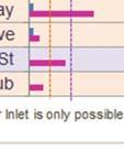
11 3. Results There was no consistently preferred times during which persons were going for swims. The results for the Te Hoiere/Pelorus River at Pelorus Bridge showed a significant peak around 2:00 pm, while the usage at Whites Bay had several peak periods. Most of the sites with lower usages had a relatively even spread of water users throughout the survey period. Figure 2: Site usage (number of persons entering the water) split into 15-minute segments for all sites monitored as part of the survey. At some coastal sites, comments on the field sheets indicated that a large number of persons were in the water above their knees during launch or retrieval of boats and kayaks. Although accidental submersion could occur, it is not very common and the activity should be considered wading, rather than swimming. Therefore, it was decided to remove these counts from the final results. However, children, who were primarily wading, were not removed from the data set due to their greater risk of accidental ingestion of water (see Section 2). In the following sections, adults and children, who were actually swimming and wading primary school aged children will be referred to as swimmers. The site, for which this modification of data had the greatest impact, was Elaine Bay, resulting in a more than four-fold reduction in the number of swimmers (see Figure 3). The modified results show that there was a large variation of the number of swimmers across the 36 sites monitored. The sites with the greatest number of swimmers were Whites Bay, Anakiwa, and the Te Hoiere/Pelorus River at Pelorus Bridge. At these sites more than a 100 persons entered the water. Sites with more than 50 swimmers were the Te Hoiere/Pelorus River at Totara Flat, the Waihopai River at Craiglochart #2 and Ngakuta Bay. On the other end of the spectrum was the Wairau River at Boyces Road and Wairau Rowing Club, where no one entered the water. Although, a number of persons visited the sites during the survey, none decided to swim. One reason was, that in the later part of the survey wind and cloud cover increased. Comments made on field sheets for a number of sites suggested that this was also the case elsewhere. Consequently, usage might have been slightly higher if weather conditions were more favourable. However, field notes at Momorangi Bay showed that despite an increase in wind speed at around 1pm, the number of persons entering the water did not changed significantly. MDC Technical Report No:
 and a surf beach (West).")
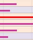
12 Figure 3: Results of the 2017 Site Usage Survey showing the number of users swimming at the individual sites. Also shown is the initial count which included persons launching and retrieving boats. Robin Hood Bay is currently monitored at two sites at opposite ends of the bay, a swimming beach (East) and a surf beach (West). Water quality monitoring so far has shown no significant differences between the two sites. The person surveying Robin Hood Bay was asked to record on which part of the bay swimming was occurring. The notes showed that the majority, 62%, of persons entered the water on the eastern side, 11% went for a swim in the middle of the bay and the remaining 27% surfed or swam on the western side. Based on these results, future monitoring should be carried out at Robin Hood Bay East. Overall the number of children recorded to enter the water was greater than the number of adults. At some sites, this difference was particularly prominent. These sites include Picton Foreshore and Shelly Beach (Figure 4). The extensive children play area at the Picton Foreshore is likely to be a major contributor for the popularity for families with children. However, at other locations, such as the 4 MDC Technical Report No:

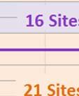
13 two sites on the Te Hoiere/Pelorus River, adults, including older children, were more likely to enter the water. The lack of shallow water at these sites is probably the main reason. Figure 4: Comparison of the number of adults and children entering the water at surveyed sites. Site currently monitored is part of the Recreational Water Quality program are indicated in purple. Figure 4 also shows which of the surveyed sites are currently monitored as part of the Recreational Water Quality Program. Most sites with more than 20 swimmers during the survey period are part of the current monitoring program; the only exceptions are Okiwi Bay and Kumutoto Bay. However, there are a number of sites currently monitored that cannot be considered popular swimming spots MDC Technical Report No:
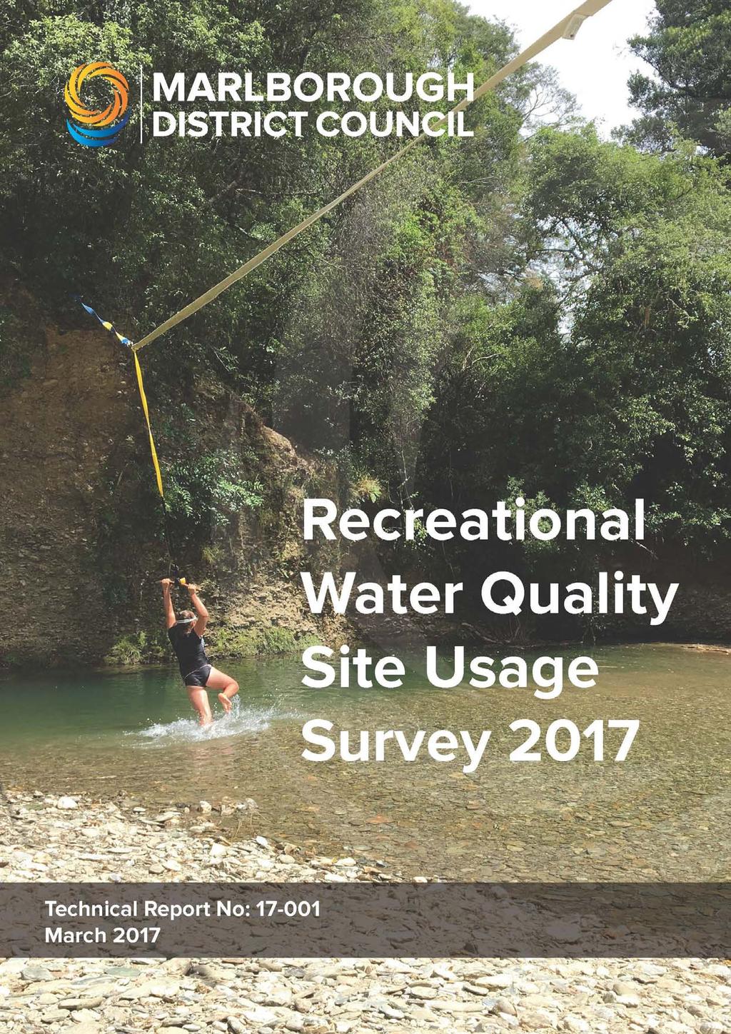
14 based on the new results. These include Marfells Beach, the Rai River at Rai Falls, Moetapu Bay Double Bay Reserve and the Wairau River at Boyces Road Conclusions and Recommendations 4.1. Monitoring Sites The purpose of the Site Usage Survey was to provide data to select future monitoring sites. Selection is targeted to minimise the risk to public health while staying within budget constraints. This means a lower cut-off point or threshold of recreational usage needs to be established. If the aim is to monitor a similar number of sites, sites surveyed and found to have a minimum of at least 10 swimmers should be selected (see Figure 5). This would result in 22 swimming locations being selected for monitoring. Ten swimmers is a relatively small number of recreational users and it needs to be questioned whether such a low usage warrants the expense of regular monitoring. Another option would be a cutoff at 20 swimmers during the survey period. This would result in 17 monitoring sites. However, this would remove the two Taylor River sites from the program. The Taylor River can be considered as a high priority water way. A large proportion of the regional population uses the recreational reserves associated with the Taylor River and good water quality is important for the enjoyment of these reserves. Combining the user counts for the two Taylor River sites would result in 25 swimmers in the river during the survey period. This would justify future monitoring of the river when the second cut-off option of 20 swimmers is implemented. There were slightly more swimmers at the Henry Street site compared to the currently monitored Riverside site. However, past investigative monitoring has shown that E. coli concentrations are much more variable and often higher at the Riverside monitoring site. Thus, from a public health point of view, the risk of a person becoming ill as a result of swimming in the river is higher at the Riverside site, despite the lower usage compared to the Henry Street site. It is therefore recommended that monitoring should continue at the Riverside monitoring site. Another consideration is the travel distance to a site. Long distances not only result in additional costs for fuel and increased vehicle wear, but also considerable staff time. Of the sites currently monitored, Mistletoe Bay is the furthest away from Blenheim at 74 kilometres (see Figure 5). If the swimming locations with at least 10 users are chosen as future monitoring sites, Okiwi Bay and Elaine Bay will need to be monitored as part of the program. Although both bays are in close proximity to each other, the driving distance from Blenheim is considerable, at 93 and 109 kilometres, respectively. This could be mitigated by employment of a local contractor to take samples and who then sends the samples to the local laboratory on the weekly courier servicing the area. Another site for which monitoring could be costly is Kumutoto Bay, because it can only be accessed by boat. One option would be to sample several sites in the Queen Charlotte Sound via boat, which would save time and potentially costs. However, sampling from boats in the past appears to have resulted in better water quality (lower Enterococci counts). This is likely caused by the fact that the samples are taken further away from the beach and therefore potential contamination sources. Although swimming is likely to occur in the deeper water, children, especially the more vulnerable 2 The Wairau River at Boyces Road is one of the many swimming locations along the Wairau River in the vicinity of the State Highway Six Bridge. Currently, samples are taken just downstream of the Bridge as a representative site. 6 MDC Technical Report No:


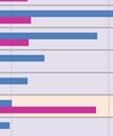

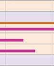


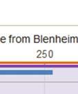


15 young children, tend to play in the shallower parts. Therefore, it is preferable to take samples from the beach rather than from a boat. Figure 5: Results of the 2017 Site Usage Survey showing the number of users swimming at the individual sites and the distance of the site from Blenheim. Also shown is whether a site currently monitored as part of the Recreational Water Quality program. The fact that Kumutoto Bay can only be accessed by boat points to the small scale of residential development and therefore insignificant sources of anthropogenic faecal contamination in this bay. For this reason, Kumutoto Bay can be considered pristine and risk to human health from accidental ingestionn of water during swimming is very low. The most likely source of faecal contaminationn is illegal dumping of sewage from visiting boats. This is a very difficult source to monitor. However, since most visitors to the bay are likely to also be recreational users, it is unlikely that illegal dumping will MDC Technical Report No:
16 occur. Due to difficult access, combined with low risk to human health, it is suggested that Kumutoto Bay is not monitored as part of the future monitoring program. Based on the above considerations, Table 2 lists the suggested sites for the future Recreational Water Quality Program 3. Type Site Easting Northing Whites Bay Robin Hood Bay - East Anakiwa Picton Foreshore Shelly Beach Waikawa Bay Momorangi Bay Ngakuta Bay Governors Bay Mistletoe Bay Moetapu - DoC Camp Okiwi Bay Elaine Bay Te Hoiere/Pelorus River at Totara Flat Te Hoiere/Pelorus River at Pelorus Bridge Ohinemahuta River at Onamalutu Domain Wairau River at Ferry Bridge Wairau River at Blenheim Rowing Club Taylor River at Riverside Taylor River at Henry St Waihopai River at Chraiglochart # Coastal Beaches Rivers sites Table 2: Suggested monitoring sites for the Recreational Water Quality Program based on the Site Usage Survey carried out January 2017 and a cut-off at a minimum of 10 swimmers during the survey. The sites marked in orange would not be monitored if a more stringent cut-off of a minimum of 20 swimmers was chosen Repeat of the Survey The usage of swimming beaches and river swimming holes can change over time as new or improved recreational reserves are built or access to a site is improved or left to deteriorate. Additionally, river sites are subject to natural changes of the riverbed during large flood events. It is therefore recommended to repeat this or a similar site usage survey after five years. If obvious changes at a particular site are resulting in a significant reduction of recreational users, a similar survey should be carried out within a shorter time frame at that site only, to confirm the changes. Based on the results the site may then be removed from the monitoring program. 3 Of course, there are many other possible site lists based on different usage cut-offs. The two options presented assume a similar level of service as in recent years and minimal changes to the budget for the program. 8 MDC Technical Report No:
17 5. Reference MDC (2012) Recreational Water Quality Report Marlborough District Council, Technical Report MDC (2016) Recreational Water Quality Report Marlborough District Council, Technical Report MfE (2003) Microbiological Water Quality Guidelines for Marine and Freshwater Recreational Areas. Ministry for the Environment MDC Technical Report No:
18 6. Appendix 1 Fieldsheet and Instructions Time Number of Adults Number of Children Comments/Other water users eg Kayaks, paddle boarders 10 MDC Technical Report No:
19 Instructions Recreational Bathing Programme Site Assessment Thanks for being part of the team that is helping the Marlborough District Council review the Recreational Bathing Water Programme. This pack has contains 2 maps showing you where the site is that you need to be. The 1st is a topo map with a general overview of how to get to the site and the second is an aerial photograph of the site. Record the people entering or in the water in the area between the two red lines. The red lines are indicative only so if someone entered the water just on the outside of the line still count them. The survey is going to take place between 12pm and 4pm so you will need to make sure that you are on site by 12pm ready to record the people using the site. We want to record the number of people who enter the water. This means any adult that goes into the water deeper than their knees or primary school aged or younger (just make an assumption on their age no need to ask them) that go in above their ankles. If a person goes in and out of the water multiple times just count them once (if you are at a busy site like Whites Bay don t panic is you cannot remember if people have been in or out before Just do what you can). Please fill in the sheet in the pack noting down the time when people enter the water. Just the approximate time is all that is required. If a group of 5 people go into the water over a 10 minute period just put down one time and record the number of adults and children against that time. Health and Safety Keeping yourself safe is the most important part of the survey. If for any reason you don t feel safe at a site simply pack and go. We are not asking you to talk to any members of the public but if people approach you feel free to tell them that you are conducting a survey on recreational bathing usage on behalf of the Marlborough District Council. I have put one of my business cards in the packs if anyone has additional questions that they would like answered just give them my details. Your packs also include some sunscreen, a water bottle and a snack. Please ensure that you are sun smart and take the appropriate precautions so that you do not get sun burnt. Other stuff We would also like a photo of the site with people using the site if possible (Cell phone quality is fine). Just a general shot of people using the site. If possible have people facing away from the camera. Feel free to take a book or whatever you want to help you pass the time of day when no one new is entering the water at your site. Also feel free to have a swim yourself (don t count yourself as a swimmer) If people want to know how to find out about water quality and where it is best to swim direct them to the LAWA website This is a website where water quality information from all regional councils around the country is presented in an easily understandable way. Back home safe When you have finished at your site and have made it back to civilization (ie home) please me at peter.hamill@marlborough.govt.nz or txt me on and let me know that you have returned safely. MDC Technical Report No:

20 7. Appendix 2 Results The counts for adults and children at each site have been combined into the nearest 15-minute interval Coastal Sites 12 MDC Technical Report No:

21 7.2. River Sites MDC Technical Report No:
Country report. Swedish bathing water quality in Sweden. May Photo: Peter Kristensen/EEA
 Country report Swedish bathing water quality in 2017 Sweden May 2018 Photo: Peter Kristensen/EEA BWD Report For the Bathing Season 2017 Sweden The report gives a general overview of information acquired
LIVERPOOL TRANSPORTATION MODELING TECHNICAL MEMO MAY 2009
 LIVERPOOL TRANSPORTATION MODELING TECHNICAL MEMO MAY 2009 Syracuse Metropolitan Transportation Council 100 Clinton Square 126 N. Salina Street, Suite 100 Syracuse, NY 13202 Telephone (315) 422-5716; Fax
Country report. Czech bathing water quality in Czech Republic. May Photo: Peter Kristensen
 Country report Czech bathing water quality in 2016 Czech Republic May 2017 Photo: Peter Kristensen BWD Report For the Bathing Season 2016 The Czech Republic The report gives a general overview of information
TRAFFIC STUDY GUIDELINES Clarksville Street Department
 TRAFFIC STUDY GUIDELINES Clarksville Street Department 9/1/2009 Introduction Traffic studies are used to help the city determine potential impacts to the operation of the surrounding roadway network. Two
2014 Fishers Trail Count
 2014 Fishers Trail Count July 2014 Table of Contents Introduction...1 Trail Count Locations...3 Ellipse Parkway at Holland Drive...4 Lantern Road at Sunblest Boulevard...5 126th Street at Cumberland Road...6
Bathing Water Directive. Ed Beard Defra Bathing Water Conference Southport March 2013
 Bathing Water Directive Ed Beard Defra Bathing Water Conference Southport March 2013 Revised Bathing Water Directive where are we going? where are we? where have we come from? 2 Compliance at coastal waters
Bathing Water Directive report Hungary
 Bathing Water Directive report 2013 Hungary The report gives a general overview of information acquired from the reported data, based on provisions of the Bathing Water Directive 1. The reporting process
Country report. Bulgarian bathing water quality in Bulgaria. May Photo: Peter Kristensen
 Country report Bulgarian bathing water quality in 2016 Bulgaria May 2017 Photo: Peter Kristensen BWD Report For the Bathing Season 2016 Bulgaria The report gives a general overview of information acquired
Country report. Swedish bathing water quality in Sweden. May Photo: Peter Kristensen
 Country report Swedish bathing water quality in 2016 Sweden May 2017 Photo: Peter Kristensen BWD Report For the Bathing Season 2016 Sweden The report gives a general overview of information acquired from
WORKING ALONE PROGRAM
 WORKING ALONE PROGRAM PURPOSE The purpose of UFV s Working Alone Program is to provide for measures to protect the health and safety of, and minimize risk to, any employees and students who work alone
COMPARING WEEKLY AND WEEKDAY AVERAGED TRAFFIC DATA WHEN MODELLING TRAFFIC NOISE. Peter Karantonis 1 and David Gonzaga 2
 ICSV14 Cairns Australia 9-12 July, 2007 COMPARING WEEKLY AND WEEKDAY AVERAGED TRAFFIC DATA WHEN MODELLING TRAFFIC NOISE Peter Karantonis 1 and David Gonzaga 2 1 Renzo Tonin & Associates (Qld) Pty Ltd L20,
Country report. Austrian bathing water quality in Austria. May Photo: Peter Kristensen
 Country report Austrian bathing water quality in 2016 Austria May 2017 Photo: Peter Kristensen BWD Report For the Bathing Season 2016 Austria The report gives a general overview of information acquired
The Economic Importance of Recreational River Use to the City of Calgary
 The Economic Importance of Recreational River Use to the City of Calgary Prepared by: Calgary River Users Alliance May 20, 2016 The Economic Importance of Recreational River Use to the City of Calgary
Bathing Water Directive report The Czech Republic
 Bathing Water Directive report 2013 The Czech Republic The report gives a general overview of information acquired from the reported data, based on provisions of the Bathing Water Directive 1. The reporting
Port Stephens Council
 Port Stephens ouncil State of the eaches 22 23 Overall results Percentage of sites graded as Good or Good: 9 Nine of the eleven swimming sites were graded as Good or Good in 22 23, a fall in performance
The frequently asked questions are grouped under headings to make it easier to find information -
 Tsunami Inundation Mapping for Hawke s Bay Frequently Asked Questions The frequently asked questions are grouped under headings to make it easier to find information - General tsunami information Tsunami
Glenn Avenue Corridor Traffic Operational Evaluation
 Glenn Avenue Corridor Traffic Operational Evaluation PREPARED FOR: THE CITY OF AUBURN PREPARED BY: DECEMBER 2007 Glenn Avenue Corridor Study--Auburn, Alabama TABLE OF CONTENTS Introduction... 1 Background
Appendix 21 Sea angling from the shore
 Appendix 21 Sea angling from the shore LUC SMRTS2015 Final Report 342 March 2016 Appendix 21 Sea angling from the shore Table A21.1: Summary of sample confidence levels Responses Spatial data Questionnaire
In order to have an enjoyable day out canoeing we need to make some key decisions to ensure we are in the right place at the right time.
 Award Description This award is designed to progress your judgment, decision making and expertise providing an understanding of journeying. As a canoeist you should be confident in planning and undertaking
Appendix 13 Rowing and sculling in the sea
 Appendix 13 Rowing and sculling in the sea Steve Thompson SMRTS2015 Final Report 251 March 2016 Appendix 13 Rowing and sculling in the sea Table A13.1: Summary of sample confidence levels Responses Spatial
EUCLID AVENUE PARKING STUDY CITY OF SYRACUSE, ONONDAGA COUNTY, NEW YORK
 EUCLID AVENUE PARKING STUDY CITY OF SYRACUSE, ONONDAGA COUNTY, NEW YORK CITY OF SYRACUSE DEPARTMENT OF PUBLIC WORKS 1200 CANAL STREET EXTENSION SYRACUSE, NEW YORK 13210 DRAFT REPORT DATE: November 13,
Bathing Water Directive report Austria
 Bathing Water Directive report 2013 Austria The report gives a general overview of information acquired from the reported data, based on provisions of the Bathing Water Directive 1. The reporting process
Calculation of Trail Usage from Counter Data
 1. Introduction 1 Calculation of Trail Usage from Counter Data 1/17/17 Stephen Martin, Ph.D. Automatic counters are used on trails to measure how many people are using the trail. A fundamental question
Country report. Lithuanian bathing water quality in Lithuania. May Photo: Peter Kristensen
 Country report Lithuanian bathing water quality in 2016 Lithuania May 2017 Photo: Peter Kristensen BWD Report For the Bathing Season 2016 Lithuania The report gives a general overview of information acquired
TROUT CREEK WATERSHED (Second Year of Snowline Data)
") Extent of Snow Cover During the 2002 Spring Freshet For the TROUT CREEK WATERSHED (Second Year of Snowline Data) (Penticton Forest District) 1.0 INTRODUCTION The extent of snow cover over a watershed basin
Extent of Snow Cover During the 2002 Spring Freshet For the TROUT CREEK WATERSHED (Second Year of Snowline Data) (Penticton Forest District) 1.0 INTRODUCTION The extent of snow cover over a watershed basin
Welcome to Scotland's Marine Tourism and Recreation Survey
 Welcome to Scotland's Marine Tourism and Recreation Survey The way Scotland's seas and coasts are managed is changing. Marine Scotland, the Scottish Government body with responsibility for managing Scotland's
Safety Assessment of Installing Traffic Signals at High-Speed Expressway Intersections
 Safety Assessment of Installing Traffic Signals at High-Speed Expressway Intersections Todd Knox Center for Transportation Research and Education Iowa State University 2901 South Loop Drive, Suite 3100
Peace River Water Use Plan. Monitoring Program Terms of Reference. GMSMON-1 Peace River Creel Survey
 Peace River Water Use Plan Monitoring Program Terms of Reference GMSMON-1 Peace River Creel Survey April 10, 2008 Terms of Reference for the Peace River Water Use Plan Monitoring Program: Peace River Creel
Monitoring Surfing Quality Below the Jordan River Generating Station (Year 3)
") Jordan River Water Use Plan Monitoring Surfing Quality Below the Jordan River Generating Station (Year 3) Reference: JORMON-5 Monitoring Surfing Quality Below the Jordan River Generating Station Study
Jordan River Water Use Plan Monitoring Surfing Quality Below the Jordan River Generating Station (Year 3) Reference: JORMON-5 Monitoring Surfing Quality Below the Jordan River Generating Station Study
Delaware Chapter Surfrider Foundation - Indian River Inlet Monitoring
 Delaware Chapter Surfrider Foundation - Indian River Inlet Monitoring In 2012, the Delaware Surfrider Foundation Chapter formed the Surf Quality and Access Committee to focus on issues such as surf spot
PUBLISHED PROJECT REPORT PPR850. Optimisation of water flow depth for SCRIM. S Brittain, P Sanders and H Viner
 PUBLISHED PROJECT REPORT PPR850 Optimisation of water flow depth for SCRIM S Brittain, P Sanders and H Viner Report details Report prepared for: Project/customer reference: Copyright: Highways England,
QUEEN ELIZABETH WAY / MARTINDALE ROAD BRIDGE DEMOLITION DETOUR ANALYSIS
 QUEEN ELIZABETH WAY / MARTINDALE ROAD BRIDGE DEMOLITION DETOUR ANALYSIS Fabio Saccon, P.Eng Area Traffic Manager Bernard James Engineer in Training Martin Sneep Senior Project Manager Lance Dutchak Traffic
Cycle journeys on the Anderston-Argyle Street footbridge: a descriptive analysis. Karen McPherson. Glasgow Centre for Population Health
 Cycle journeys on the Anderston-Argyle Street footbridge: a descriptive analysis Karen McPherson Glasgow Centre for Population Health March 2017 Key points: There were 116,334 cycle journeys made using
Country report. Danish bathing water quality in Denmark. May Photo: Peter Kristensen
 Country report Danish bathing water quality in 2016 Denmark May 2017 Photo: Peter Kristensen BWD Report For the Bathing Season 2016 Denmark The report gives a general overview of information acquired from
Country report. Italian bathing water quality in Italy. May Photo: Peter Kristensen
 Country report Italian bathing water quality in 2016 Italy May 2017 Photo: Peter Kristensen BWD Report For the Bathing Season 2016 Italy The report gives a general overview of information acquired from
Of the following, which best describes you?
 Summary of Downtown Des Moines Dam Debate April 26 th, 2016 The following are the responses we heard from participants in the Dam Debate cohosted by the Register and the Des Moines Area Metropolitan Planning
EXECUTIVE SUMMARY Callan Park accommodates travel from a wide range of transport modes, including walking, cycling, bus and light rail.
 TRANSPORT AND ACCESS EXECUTIVE SUMMARY Callan Park accommodates travel from a wide range of transport modes, including walking, cycling, bus and light rail. Whilst there are some walking facilities within
Country report. Belgian bathing water quality in Belgium. May Photo: Peter Kristensen/EEA
 Country report Belgian bathing water quality in 2017 Belgium May 2018 Photo: Peter Kristensen/EEA BWD Report For the Bathing Season 2017 Belgium The report gives a general overview of information acquired
Monitoring Surfing Quality below the Jordan River Generating Station (Year 2)
") Jordan River Project Water Use Plan Monitoring Surfing Quality below the Jordan River Generating Station (Year 2) Reference: JORMON#5 Monitoring Surfing Quality Below the Jordan River Generating Station
Jordan River Project Water Use Plan Monitoring Surfing Quality below the Jordan River Generating Station (Year 2) Reference: JORMON#5 Monitoring Surfing Quality Below the Jordan River Generating Station
SURGE SUPPRESSION ACHIEVED BY DIFFERENT COASTAL SPINE (IKE DIKE) ALIGNMENTS. Bruce A. Ebersole, Thomas W. Richardson and Robert W.
 ALIGNMENTS. Bruce A. Ebersole, Thomas W. Richardson and Robert W.") SURGE SUPPRESSION ACHIEVED BY DIFFERENT COASTAL SPINE (IKE DIKE) ALIGNMENTS Abstract Bruce A. Ebersole, Thomas W. Richardson and Robert W. Whalin, Jackson State University, Jackson, Mississippi The primary
SURGE SUPPRESSION ACHIEVED BY DIFFERENT COASTAL SPINE (IKE DIKE) ALIGNMENTS Abstract Bruce A. Ebersole, Thomas W. Richardson and Robert W. Whalin, Jackson State University, Jackson, Mississippi The primary
Proportion (%) of Total UK Adult Population (16+)s. Participating in any Watersports Activity
 of Total UK Adult Population (16+)s. Participating in any Watersports Activity") Proportion (%) of Total UK Adult Population (16+)s Participating in any Watersports Activity Headlines Participation in any activities up 2.1% point 14.3m UK adults participating Highest volume recorded
Proportion (%) of Total UK Adult Population (16+)s Participating in any Watersports Activity Headlines Participation in any activities up 2.1% point 14.3m UK adults participating Highest volume recorded
WANAKA SWIMMING FACILITIES STATEMENT OF PROPOSAL
 WANAKA SWIMMING FACILITIES STATEMENT OF PROPOSAL 17 October 2014 Contents Executive Summary Background National Guidelines The Status Quo Issue One Timing Issue Two Location Issue Three Size Issue Four
Appendix 9 SCUBA diving in the sea
 Appendix 9 SCUBA diving in the sea Firth of Clyde Forum SMRTS2015 Final Report 195 March 2016 Appendix 9 SCUBA diving in the sea Table A9.1: Summary of sample confidence levels Responses Spatial data Questionnaire
Modal Shift in the Boulder Valley 1990 to 2009
 Modal Shift in the Boulder Valley 1990 to 2009 May 2010 Prepared for the City of Boulder by National Research Center, Inc. 3005 30th Street Boulder, CO 80301 (303) 444-7863 www.n-r-c.com Table of Contents
Bathing Water Directive report Greece
 Bathing Water Directive report 2013 Greece The report gives a general overview of information acquired from the reported data, based on provisions of the Bathing Water Directive 1. The reporting process
Bathing Water Directive report Bulgaria
 Bathing Water Directive report 2013 Bulgaria The report gives a general overview of information acquired from the reported data, based on provisions of the Bathing Water Directive 1. The reporting process
Bathing Water Directive report Finland
 Bathing Water Directive report 2013 Finland The report gives a general overview of information acquired from the reported data, based on provisions of the Bathing Water Directive 1. The reporting process
Midtown Corridor Alternatives Analysis
 Midtown Corridor Alternatives Analysis Ridership Forecast Methodology and Results December 2013 Prepared by the SRF Consulting Group Team for Table of Contents Introduction... 1 Methodology... 1 Assumptions...
Traffic Control Signals Review 4325 McCowan Road
 REPORT FOR ACTION Traffic Control Signals Review 4325 McCowan Road Date: March 15, 2018 To: Scarborough Community Council From: Director, Transportation Services, Scarborough District Wards: Ward 41 Scarborough
Country report. Croatian bathing water quality in Croatia. May Photo: Peter Kristensen
 Country report Croatian bathing water quality in 2016 Croatia May 2017 Photo: Peter Kristensen BWD Report For the Bathing Season 2016 Croatia The report gives a general overview of information acquired
Memorandum INTRODUCTION METHODOLOGY. Smart Growth. Bruce Robinson, Transport Advisor, Infrastructure Planning
 Memorandum To: Smart Growth From: Bruce Robinson, Transport Advisor, Infrastructure Planning Subject: Te Tumu Transportation Assessment: Stage 1 Sensitivity Analysis Date: 1 June 2016 INTRODUCTION This
Pedestrian Crossing Guidelines 2016
 Pedestrian Crossing Guidelines 2016 Engineering Services 1.0 Introduction and Background The City of Kingston s first Pedestrian Crossing Guidelines were approved by Council in 2008 in order to provide
Monitoring beach usage on Gold Coast beaches: Is it beneficial?
 Monitoring beach usage on Gold Coast beaches: Is it beneficial? Peta Williams 1, Gervase Tuxworth 2 and Chris Lane 2 1 Griffith Centre for Coastal Management (GCCM) Gold Coast Campus, Griffith University
Examination of the Effect of Driver Population at Freeway Reconstruction Zones
 Al-Kaisy & Hall 2 Examination of the Effect of Driver Population at Freeway Reconstruction Zones Ahmed Al-Kaisy and Fred Hall ABSTRACT This paper presents an investigation into the effect of the driver
This objective implies that all population groups should find walking appealing, and that it is made easier for them to walk more on a daily basis.
 Walking for life The Norwegian Walking Strategy Guro Berge Norwegian public Roads Administration "Walking for life" is the slogan for the National Walking Strategy that is now being formulated in Norway.
Aim. Survey Methodology
 The fish that smells of cucumber: conservation of smelt Osmerus eperlanus in the Thames Estuary Interim Report on results of 2015 survey work Joanna Barker Project Manager, Europe Conservation Programme
RACE BRIEFING TREMAINS TRIATHLON 19 T RI TOGETHER
 TREMAINS TRIATHLON 19 T RI TOGETHER RACE BRIEFING Thank you for entering the Tremains Triathlon. With the support of sponsors and your entry all proceeds are returned to our community through Triathlon
A REVIEW OF AGE ADJUSTMENT FOR MASTERS SWIMMERS
 A REVIEW OF ADJUSTMENT FOR MASTERS SWIMMERS Written by Alan Rowson Copyright 2013 Alan Rowson Last Saved on 28-Apr-13 page 1 of 10 INTRODUCTION In late 2011 and early 2012, in conjunction with Anthony
SMOOTH HAMMERHEAD SHARK (HHS)
") SMOOTH HAMMERHEAD SHARK (HHS) (Sphyrna zygaena) HHS1 1. FISHERY SUMMARY Smooth hammerhead sharks (Sphyrna zygaena) are not currently managed under the QMS. No assigned fishing allowances exist. However,
SMOOTH HAMMERHEAD SHARK (HHS) (Sphyrna zygaena) HHS1 1. FISHERY SUMMARY Smooth hammerhead sharks (Sphyrna zygaena) are not currently managed under the QMS. No assigned fishing allowances exist. However,
Travel and Rider Characteristics for Metrobus
 Travel and Rider Characteristics for Metrobus 040829040.15 Travel and Rider Characteristics for Metrobus: 2012-2015 Overview The Miami Dade County Metropolitan Planning Organization (MPO) conducted a series
Narrows West. Lots For Sale Overview
 Lots For Sale Overview Spring/Summer Sales Book 2017 My family has been living at the Lake Manitoba Narrows for approximately 100 years. One of my grandfathers settled on the west shore of the Narrows
To: The results of these surveys have been analysed and are summarised within this Technical Note.
 Technical Note Project: Histon Road / Milton Road, Cambridge Parking Surveys To: Andy Harrison Subject: Survey Report v1.6 From: Jonathan Barlow Date: 18 th February 2016 cc: Richard Jones / Dave Boddy
North Kitsap Trails Association: String of Pearls Trails Survey Results July 13, 2010
 North Kitsap Trails Association: String of Pearls Trails Survey Results July 13, 2010 Who Responded to the Survey and Where Do They Live? The NKTA String of Pearls Trails Survey was completed online using
5. The speed camera site outside the Parkwood Rest Home opposite Linwood College is a valuable deterrent. The speed camera site should be retained.
 27. ALDWINS ROAD SPEED LIMIT General Manager responsible: General Manager City Environment, DDI 941-8656 Officer responsible: Author: PURPOSE OF THE REPORT Unit Manager, Transport and Greenspace Brian
RIVER ACCESS STRATEGY RIVER USAGE AND ATTITUDES BASELINE ONLINE SURVEY SUMMARY REPORT
 RIVER ACCESS STRATEGY RIVER USAGE AND ATTITUDES BASELINE ONLINE SURVEY JUNE 2014 RIVER ACCESS STRATEGY RIVER USAGE AND ATTITUDES SURVEY BACKGROUND The North Saskatchewan River Valley is one of North America
ROCK CLIMBING STRATEGY
 Stawamus Chief, Shannon Falls & Murrin Provincial Parks ROCK CLIMBING STRATEGY Prepared by: Ministry of Environment, Lands and Parks BC Parks, Garibaldi/Sunshine Coast District Brackendale, BC and Volunteer
Appendix B: Forecasting and Traffic Operations Analysis Framework Document
 Existing Conditions Report - Appendix Appendix B: Forecasting and Traffic Operations Analysis Framework Document This document defines the methodology and assumptions that will be used in the traffic forecasting
Jordan River Project Water Use Plan
 Jordan River Project Water Use Plan Monitoring Surfing Quality below the Jordan River Generating Station Implementation Year 5 Reference: JORMON-5 Study Period: March 5 to April 1, RRL Recreation Resources
APPENDIX H EXISTING TRAFFIC CONDITIONS ANALYSIS
 APPENDIX H EXISTING TRAFFIC CONDITIONS ANALYSIS MEMO : Peter Steacy, P.Eng. Date: December 3, 2014 : Ian Borsuk, P.Eng. Job No.: 3414015-000 Subject: City of Ottawa O-Train Extension Planning & EA Study
SECTION 2 HYDROLOGY AND FLOW REGIMES
 SECTION 2 HYDROLOGY AND FLOW REGIMES In this section historical streamflow data from permanent USGS gaging stations will be presented and discussed to document long-term flow regime trends within the Cache-Bayou
Will Kempton, Chief Executive Officer. Update on Proposed Implementation of a Wayside Horn System Along the San Clemente Beach Trail
 May 27, 2010 To: From: Subject: Transit Committee Will Kempton, Chief Executive Officer System Along the San Clemente Beach Trail Overview The Orange County Transportation Authority and City of San Clemente
105 CMR MINIMUM STANDARDS FOR BATHING BEACHES STATE SANITARY CODE, CHAPTER VII
 105 CMR 445.000 MINIMUM STANDARDS FOR BATHING BEACHES STATE SANITARY CODE, CHAPTER VII 445.001: Purpose The purpose of 105 CMR 445.000 is to protect the health, safety and well-being of the users of bathing
RIVER CROSSINGS: EAST OF SILVERTOWN CROSSINGS
 TRANSPORT FOR LONDON RIVER CROSSINGS: EAST OF SILVERTOWN CROSSINGS SUPPORTING TECHNICAL DOCUMENTATION TRAFFIC IMPACT REPORT Neil Georgeson July 2014 This report examines the traffic impacts that potential
Strategic Director for Environment. Enclosures Appendix A - Option drawings. Jamie Blake- Strategic Director for Environment
 Chipping Barnet Area Committee 9 July 2018 Title Report of Wards Status Urgent Key Cromer Road Request for 20mph Zone Strategic Director for Environment High Barnet Public No No Enclosures Appendix A -
Chicago Public Schools Policy Manual
 Chicago Public Schools Policy Manual Title: AQUATIC ACTIVITY SAFETY Section: 604.6 Board Report: 18-0627-PO2 Date Adopted: June 27, 2018 Policy: THE CHIEF EXECUTIVE OFFICER RECOMMENDS: That the Board rescind
Caltrans compendium of underwater sound data from pile driving 2014 update
 Caltrans compendium of underwater sound data from pile driving 2014 update Richard RODKIN 1 ; Keith POMMERENCK 2 1 Illingworth & Rodkin, Inc., United States 2 Illingworth & Rodkin, Inc., United States
SACO RIVER AND CAMP ELLIS BEACH SACO, MAINE SECTION 111 SHORE DAMAGE MITIGATION PROJECT APPENDIX F ECONOMIC ASSESSMENT
 SACO RIVER AND CAMP ELLIS BEACH SACO, MAINE SECTION 111 SHORE DAMAGE MITIGATION PROJECT APPENDIX F ECONOMIC ASSESSMENT Department of the Army New England District, Corps of Engineers 696 Virginia Road
Speed Limit Policy Isle of Wight Council
 APPENDIX B Speed Limit Policy Isle of Wight Council 2009 Contents Section 1 Introduction 1.1 Links with the Local Transport Plan Section 2 Speed Limits on Urban Roads and Residential Areas 2.1 20mph Limits
Traffic Impact Study. Westlake Elementary School Westlake, Ohio. TMS Engineers, Inc. June 5, 2017
 TMS Engineers, Inc. Traffic Impact Study Westlake Elementary School Westlake, Ohio June 5, 2017 Prepared for: Westlake City Schools - Board of Education 27200 Hilliard Boulevard Westlake, OH 44145 TRAFFIC
IGEM/TD/2 Edition 2 with amendments July 2015 Communication 1779 Assessing the risks from high pressure Natural Gas pipelines
 Communication 1779 Assessing the risks from high pressure Natural Gas pipelines Founded 1863 Royal Charter 1929 Patron: Her Majesty the Queen Communication 1779 Assessing the risks from high pressure Natural
Wildlife Ad Awareness & Attitudes Survey 2015
 Wildlife Ad Awareness & Attitudes Survey 2015 Contents Executive Summary 3 Key Findings: 2015 Survey 8 Comparison between 2014 and 2015 Findings 27 Methodology Appendix 41 2 Executive Summary and Key Observations
Drowning Deaths at Public Swimming Pools. Dr Bernadette Matthews Principal Research Associate Aquatic Risk and Research Life Saving Victoria
 Drowning Deaths at Public Swimming Pools Dr Bernadette Matthews Principal Research Associate Aquatic Risk and Research Life Saving Victoria http://www.cvent.com/d/yvqzhg SURVEY DROWNING DEATHS IN VICTORIA
PAEKĀKĀRIKI HILL ROAD / BEACH ROAD / SH1 INTERSECTION PROGRESS REPORT
 Chairperson and Committee Members ENVIRONMENT AND COMMUNITY DEVELOPMENT COMMITTEE 6 DECEMBER 2011 Meeting Status: Public Purpose of Report: For Decision PAEKĀKĀRIKI HILL ROAD / BEACH ROAD / SH1 INTERSECTION
Hewson Planning 35 Corbett Road RD2 Whangarei 082. Attachment 5. Traffic Assessment
 Hewson Planning 35 Corbett Road RD2 Whangarei 082 Attachment 5. Traffic Assessment 1 Engineering Outcomes, Limited 132 Beach Road PO Box 3048, Onerahi Whangarei New Zealand Telephone 09 436 5534 Mobile
Surfrider s Recreational Use Survey and Marine Spatial Planning in Washington State. Gus Gates- WA Policy Manager
 Surfrider s Recreational Use Survey and Marine Spatial Planning in Washington State Gus Gates- WA Policy Manager Overview Background on MSP and Rec Study Stakeholder outreach Collaboration w/ OCNMS staff
At-Grade Intersections versus Grade-Separated Interchanges (An Economic Analysis of Several Bypasses)
") Transportation Kentucky Transportation Center Research Report University of Kentucky Year 1975 At-Grade Intersections versus Grade-Separated Interchanges (An Economic Analysis of Several Bypasses) Kenneth
Transportation Kentucky Transportation Center Research Report University of Kentucky Year 1975 At-Grade Intersections versus Grade-Separated Interchanges (An Economic Analysis of Several Bypasses) Kenneth
MEMORANDUM. To: 1.0 PURPOSE
 MEMORANDUM To: Scott Holland, Elements Architecture From: Brian Grover, Dudek Date: July 16, 2014 1.0 PURPOSE In response to the November 4, 2013 request (RE: Incomplete Application Southern California
JONESBORO HIGHWAY 63 HIGHWAY 18 CONNECTOR STUDY
 JONESBORO HIGHWAY 63 HIGHWAY 18 CONNECTOR STUDY Craighead County May 2007 JONESBORO HIGHWAY 63 HIGHWAY 18 CONNECTOR STUDY Craighead County May 2007 Prepared by Planning and Research Division Arkansas State
Appendix 22 Sea angling from a private or chartered boat
 Appendix 22 Sea angling from a private or chartered boat LUC SMRTS2015 Final Report 359 March 2016 Appendix 22 Sea angling from a private or chartered boat Table A22.1: Summary of sample confidence levels
CITY COUNCIL AGENDA REPORT
 CITY COUNCIL AGENDA REPORT Subject: GROSVENOR POOL REPORT Recommendation(s) 1. That the Grosvenor Outdoor Pool Report Part 2, 2015, provided as Attachment 1 to the Grosvenor Pool Report agenda report dated
TRANSPORTATION ANALYSIS REPORT US Route 6 Huron, Erie County, Ohio
 TRANSPORTATION ANALYSIS REPORT US Route 6 Huron, Erie County, Ohio December 12, 2012 Prepared for: The City of Huron 417 Main Huron, OH 44839 Providing Practical Experience Technical Excellence and Client
#!! "$% ##! &! # '#! % $ #!
 Executive Summary US Highway 16 (US 16) is the primary corridor connecting Rapid City to the Black Hills region. It serves a growing population of commercial and residential traffic, as well as seasonal
NORTH HAVEN NORTH HAVEN SLSC
 NORTH HAVEN NORTH HAVEN SLSC Patrols: November to March, weekends and public holidays North Haven beach is the product of a major redevelopment of the northern part of the Adelaide coast. In the 1980s,
Rob Greenaway & Associates
 Port Marlborough NZ Ltd Waikawa Plan Change Marina Berths Demand Assessment and Recreation Assessment of Effects February 2010 www.greenaway.co.nz Port Marlborough NZ Ltd Waikawa Plan Change Recreation
Report to Cabinet. 18 May 2016
 Agenda Item 8 Report to Cabinet 18 May 2016 Subject: Presenting Cabinet Member: Proposed CCTV Enforcement of Traffic Contraventions in a Bus Lane (Key Decision Ref. No. HE030) Highways and Environment
Huckleberry Finn By Peter Townend
 A message Message to Huckleberry Finn Huckleberry Finn By Peter Townend A good low brace can save your bacon in a range of conditions. This is one paddle stroke to practise at every opportunity. The first
CITY CLERK. (City Council on October 2, 3 and 4, 2001, adopted this Clause, without amendment.)
") CITY CLERK Clause embodied in Report No. 7 of the, as adopted by the Council of the City of Toronto at its meeting held on October 2, 3 and 4, 2001. 15 Draft By-laws- Installation of Speed Humps - Various
CITY CLERK Clause embodied in Report No. 7 of the, as adopted by the Council of the City of Toronto at its meeting held on October 2, 3 and 4, 2001. 15 Draft By-laws- Installation of Speed Humps - Various
Student Pedestrian Safety Fiddlers Canyon Elementary Community Council 2012
 Student Pedestrian Safety Fiddlers Canyon Elementary Community Council 2012 Introduction Fiddlers Canyon Elementary students must cross North Wedgewood Lane and Fiddlers Canyon Drive in order to come to
The 2001 Economic Benefits of Hunting, Fishing and Wildlife Watching in MISSOURI. Prepared by:
 The 2001 Economic Benefits of Hunting, Fishing and Wildlife Watching in MISSOURI Prepared by: Southwick Associates, Inc. PO Box 6435 Fernandina Beach, FL 32035 Ph (904) 277-9765 Fax (904) 261-1145 Email:
Appendix E Mangaone Stream at Ratanui Hydrological Gauging Station Influence of IPO on Stream Flow
 NZ Transport Agency Peka Peka to North Ōtaki Expressway Hydraulic Investigations for Expressway Crossing of Mangaone Stream and Floodplain Appendix E Mangaone Stream at Ratanui Hydrological Gauging Station