Southview Blvd & 3 rd Avenue Improvement Project. Public Open House December 4, to 7pm
|
|
|
- Cassandra Blankenship
- 5 years ago
- Views:
Transcription
1 Southview Blvd & 3 rd Avenue Improvement Project Public Open House December 4, to 7pm

2 Southview Blvd & 3 rd Avenue Public Information Meeting Agenda Presentation 5:30 to 6:15 pm Purpose of Project Opportunities with Project Proposed Draft Corridor Concepts Schedule and Next Steps Open House Format 6:15 to 7pm Discuss Project Elements with Staff
3 Introductions Project Staff Chris Hartzell, Dakota County Project Manager John Sachi, City of South St. Paul City Engineer Chris Chromy, Consultant Project Manager/Engineer Angie Bersaw, Consultant Transportation Planner Jake Bongard, Consultant Transportation Engineer

4 Audience Polling How do I use my clicker? Press number on clicker that corresponds to an answer that is asked. Allows for instant polling of the group. Let s Practice.
5 Q1. I would consider myself a fan of. 29% A. Elvis 24% 26% B. The Beatles C. The Rolling Stones D. Madonna E. Johnny Cash F. Florida Georgia Line 9% 9% 3% Elvis The Beatles The Rolling Stones Madonna Johnny Cash Florida Georgia Line
6 Project Overview County & City planning for a project in 2016/2017 Preliminary design (Now March 2015) Define WHAT will be built Width of road and pavement Sidewalks and amenities Parking and boulevard space Final design (March 2015 to 2016) Define HOW it will be built Construction staging and sequencing Material types and quantities

7 Decision Making Process Coordination Community Input City of South St. Paul
8 Purpose of Meeting Review project need Gather input on elements of proposed design concepts Review where we have been: Public Information Meeting #1 August 7 th Business Advisory #1 September 30 th Business Advisory #2 November 25 th


9 Nov 25 th Business Advisory Committee Input Concerns raised: Reduction of on-street parking Potential driveway access changes/closures Intersection traffic control changes Pedestrian safety Project costs and assessments

10 Q2. How would you best describe your interest in the Southview Blvd/3 rd Ave Project? A. Resident B. Business Owner/Operator C. Business Property Owner D. Interested Citizen E. Elected Official F. Other 36% 25% 14% 22% 3% 0% Resident Business Owner/Operator Business Property Owner Interested Citizen Elected Official Other
11 Q3. Did you attend previous public meetings for the Southview Blvd/3 rd Ave Project? A. Aug 7 th Open House B. Sept 30 th Business Advisory C. Nov 25 th Business Advisory D. Two or more of the above E. This is my first meeting 29% 0% 3% 20% 49% Aug 7th Open House Sept 30th Business Advisory Nov 25th Business Advisory Two or more of the above This is my first meeting

12 Needs In Project Area Pedestrian movements hindered primary reason for project Obstructed sight lines at intersections Poor street lighting Transit stops provide no shelter from weather 77 vehicle crashes over 3 years 19 involving parked cars 3 involving pedestrian or bicyclist High occurrence of crashes at intersections Delay and back up at 20 th Avenue


13 Project Needs Pedestrian movements hindered by: uneven sidewalks cluttered with benches, trash cans, planters, trees and tree grates


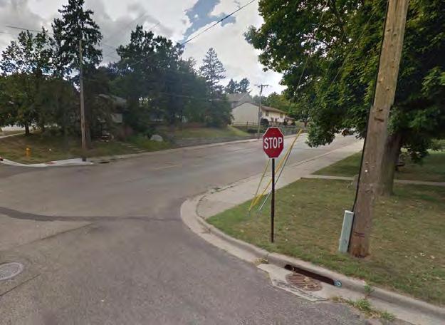
14 Project Needs Obstructed sight lines at intersections 19 th Ave 13 th Ave 18 th Ave 8 th Ave


15 Project Needs Inconsistent street lighting Inconsistent spacing of street lighting leads to hotspots and dark areas Residential Segment Business District Segment


16 Project Needs Transit stops lack shelter from weather, buses block traffic

17 Project Needs High occurrence of crashes at 5 th Avenue intersection 6 crashes in 3 years 4 right angle crashes Limited visibility Stop sign violations Higher crashes than expected Eastbound Southview at 5 th Ave

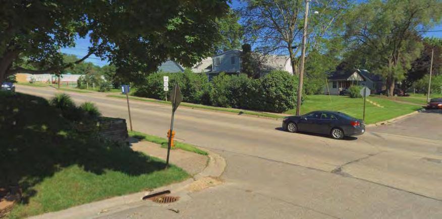
18 Project Needs High occurrence of crashes at 7 th Avenue intersection 9 crashes in 3 years 2 right angle crashes 2 rear end crashes 3 left turn crashes 1 pedestrian crash Eastbound Southview at 7 th Ave
19 Project Needs High occurrence of crashes at 12 th Avenue intersection 9 crashes in 3 years 6 rear end crashes Limited visibility Eastbound Southview at 12 th Ave

20 Project Needs High occurrence of crashes at 13 th Avenue intersection 7 crashes in 3 years 3 right angle crashes Limited visibility Overlapping turning movements in nearby driveways More than double the crashes expected Eastbound Southview at 13 th Ave

21 Project Needs High occurrence of crashes at 18 th Avenue intersection 6 crashes in 3 years 4 rear end crashes Southview Blvd left turning vehicles block through traffic More than double the crashes expected Eastbound Southview at 18 th Ave

22 Project Needs Delay and backup at 20 th Avenue intersection seconds average right turn delay More than a minute delay for right turns at peak times 4-6 cars back up Right turn is at capacity


23 Q4. Based on the Project Needs presented, are we accurately reflecting the problems you encounter traveling through the corridor on foot, bike, bus and automobile? A. Strongly Agree B. Agree C. Neutral D. Disagree E. Strongly Disagree 32% 24% 21% 18% 6% Strongly Agree Agree Neutral Disagree Strongly Disagree
 Open House #2 (January 23, 2014) Open House #3 (March 27, 2014) Online surveys Stakeholder meetings and phone calls Planning Commission and City Council meetings")
24 Opportunities with the Project Begin Southview Hill Area Study Implementation: Study purpose - identify revitalization opportunities for Southview and Marie businesses Community input opportunities: Open House #1 (October 10, 2013) Open House #2 (January 23, 2014) Open House #3 (March 27, 2014) Online surveys Stakeholder meetings and phone calls Planning Commission and City Council meetings Study adopted in April 2014

25 Opportunities with the Project Study Recommendations for Southview Blvd: Consider public realm improvements to elevate the area s character and promote placemaking Promote designs that encourage walking and transit use in addition to efficient vehicular travel Explore feasibility of more pedestrian space by removing and relocating some on-street parking to new public parking lots Install high-quality, branded wayfinding and gateway elements
26 Streetscape Opportunities Sense of Place Safety Mobility (All Modes) Inviting for Business Investment in Community
27 Elements of a Streetscape Travel Zone Parking Zone Amenity Zone Pedestrian Access Zone
28 Pedestrian Access Zone Features Pedestrian Access Route Simple /Clear Pavement Design Accessibility to Storefronts
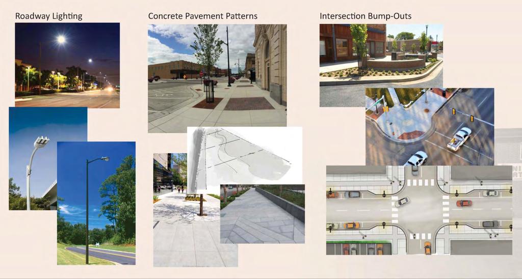
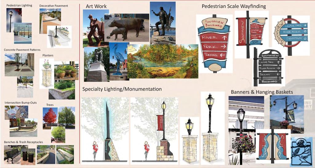
29 Possible Amenity Zone Features Landscaping (Trees/Planters) Decorative Pavement Lighting Seating Wayfinding Signage Banners/Hanging Baskets Artwork

30 Base Level Streetscape

31 Middle Level Streetscape
32 High Level Streetscape

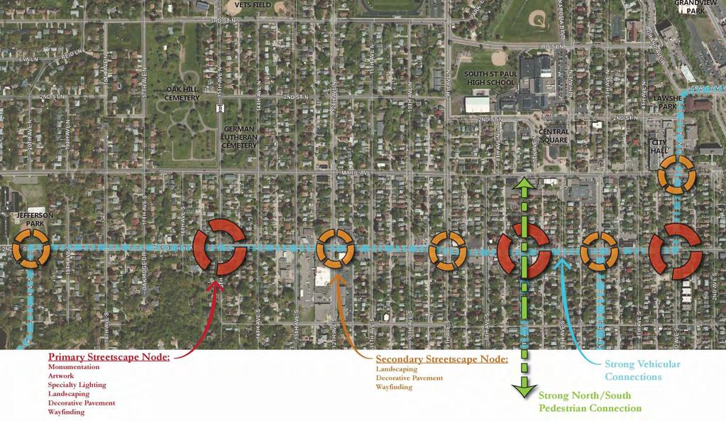
33 Streetscape Nodes Primary and Secondary
34 Opportunities with the Project Mid-block design flexibility Need to understand how to best allocate space within existing right-of-way There are certain requirements Flexibility with other elements Needs are expected to be different at different locations in the corridor
 Increase width of elements Parking or No Parking Add Amenity zone/boulevard/snow Add left turn lane")
35 Elements Competing for Space Minimum requirements: (44-52 ) 11 travel lanes 5 shoulder (no parking) 8-10 parking 5-6 sidewalk each side Options for remaining space: (8-16 ) Increase width of elements Parking or No Parking Add Amenity zone/boulevard/snow Add left turn lane (12 )


36 Mid-Block Design Flexibility We need your input on how to allocate space where flexibility exists: On-street parking Streetscape amenity zone/boulevards/snow storage Pedestrian access route What are your must haves? What can you give up to maintain your must haves?
37 Q5. In your opinion, how important is it to improve pedestrian facilities (clear path, wider sidewalks)? A. Very important 41% B. Somewhat important C. Neutral D. Not important 24% 26% E. No opinion 9% 0% Very important Somewhat important Neutral Not important No opinion

? A.")


38 Q6. In your opinion, how important is it to provide streetscape amenities (trees, benches, planters, etc.)? A. Very important B. Somewhat important C. Neutral D. Not important E. No opinion 42% 33% 17% 8% 0% Very important Somewhat important Neutral Not important No opinion
 B. On-street parking directly outside of a business C.")

39 Q7. In your opinion, which is more important to you as a business patron? A. Off-street parking (either private or public lot) B. On-street parking directly outside of a business C. On-street parking within 1 block of a business D. On-street parking within a few blocks of a business E. No opinion 39% 44% 17% Off-street parking (either priva.. On-street parking directly outs... On-street parking within 1 bloc... On-street parking within a few... 0% 0% No opinion
40 Intersection Traffic Control Intersection control beyond a thru-stop requires a detailed engineering study that considers: Traffic volume levels on the major and minor street Throughout a typical day, including peak period(s) Conflicting crossing and turning movements Crash history and potential with each option Capacity and delay potential with each option Pedestrian activity and type of pedestrians Conditions within the intersection
41 Intersection Traffic Control Identified potential traffic control changes needed at: 20 th Avenue current all-way stop 12 th Avenue current traffic signal 7 th Avenue current traffic signal 3 rd Avenue current all-way stop


42 Intersection Traffic Control Types of Traffic Control for Southview Blvd project Thru-Stop All-Way Stop Roundabout Mini-Roundabout
43 Intersection Traffic Control Pedestrian Safety Thru-Stop Control Single-stage pedestrian crossing Very little impact to mainline vehicle speeds 7% compliance for vehicles stopping for pedestrian on the curb, waiting to cross Driver awareness to pedestrians: Moderate Pedestrian awareness to drivers: Moderate
44 Intersection Traffic Control Pedestrian Safety All-Way Stop Control Single-stage pedestrian crossing Potentially reduces vehicle speeds Near 100% compliance since vehicles required to stop at the STOP sign. Driver awareness to pedestrians: Moderate Pedestrian awareness to drivers: Moderate

45 Intersection Traffic Control Pedestrian Safety Roundabout Two-stage pedestrian crossing Wide median refuge Improves safety by allowing pedestrian to focus on crossing one direction of traffic at a time Reduced vehicle speeds Driver awareness to pedestrians: High Pedestrian awareness to drivers: High 1 2 3

46 Intersection Traffic Control Pedestrian Safety Mini-Roundabout Single-stage pedestrian crossing Narrow median refuge Crossing similar to conventional intersection Reduced vehicle speeds Driver awareness to pedestrians: Moderate Pedestrian awareness to drivers: Moderate 1 2 Median Too Narrow To Safely Accommodate Pedestrians
 Primary")
47 Intersection Traffic Control 20 th Avenue Primary movements (76% or more) Consider alternatives to allow more free-flow condition for primary movements Maintain all-way stop Reconfigure intersection Roundabout (regular or mini) Primary Movements
 Consider alternatives to allow")

48 Intersection Traffic Control 3 rd Avenue Primary movements (44% or more) Consider alternatives to allow more free-flow condition for primary movements All-way stop Mini-Roundabout Southview Blvd 3 rd Ave Primary Movements

49 Intersection Traffic Control 7 th Avenue and 12 th Avenue Intersections Traffic signals are not justified to serve intersection traffic volumes levels Traffic signal equipment beyond its useful life, costly to replace Fewer crashes expected WITHOUT a traffic signal


50 Intersection Traffic Control 7 th Avenue Intersection All-way stop, Mini-roundabout, or thru-stop are appropriate at this location All-way stop reduces unnecessary delay by as much as 35% reduction during off-peak 45% reduction during peak Bump-outs/ Narrowed Roadway Mini-Roundabout


51 Intersection Traffic Control 12 th Avenue Intersection Thru-stop Control is most appropriate at this location Improved visibility from side streets is necessary Bump-outs Reduces unnecessary delay by as much as 75% reduction during off-peak 70% reduction during peak Existing Bump-outs/ Narrowed Roadway
52 Draft Corridor Concepts Three different approaches Balanced Mobility Concept Roundabout Concept Vehicle-Orientated Concept Pieces of each concept can be combined Our responsibility is to pull together an overall corridor that functions as a system with many parts
53 Balanced Mobility Corridor Concept Balances: Space for pedestrians, streetscape and transit amenities Movement of vehicular traffic Improves intersection sight lines Reduces crossing distance for pedestrians
 Most efficiently moves vehicular traffic Improves intersection sight lines Reduces crossing distance for")
54 Roundabout Corridor Concept Increases space for pedestrians, streetscape and transit amenities (but less than Balanced Mobility Concept) Most efficiently moves vehicular traffic Improves intersection sight lines Reduces crossing distance for pedestrians
 Some reduction in pedestrian crossing")
55 Vehicle Oriented Corridor Concept Greater focus on efficiently moving vehicular traffic Turn lanes to separate movements Focus on primary intersection movements Increases space for pedestrians, streetscape and transit amenities (but less than other concepts) Some reduction in pedestrian crossing distance

 Public Open House #3 (February) Public")
56 Next Steps Iterative process to refine and evaluate concepts; arrive at a Sustainable Solution Opportunities for continued involvement: Business Advisory Committee (January) Citizens Advisory Committee (January) Public Open House #3 (February) Public Open House #4 (March)
57 Your Input Tonight We need your input on what elements are most important to you and where does flexibility exist: On-street parking specific locations Streetscape amenity zone/boulevards/nodes Sidewalk width pedestrian access route Talk with project staff Fill out a comment form or staff
58 Project Contacts Chris Hartzell Dakota County Chris Chromy Bolton & Menk John Sachi South St. Paul Angie Bersaw Bolton & Menk Like us on Facebook
UNIVERSITY AVENUE CORRIDOR REDESIGN. January 8, 2017 PUBLIC OPEN HOUSE
 January 8, 2017 PUBLIC OPEN HOUSE COLLABORATIVE COMMUNITY-BASED DESIGN IS THE FOUNDATION TO A SUCCESSFUL PROJECT AGENDA FOR TONIGHT 1 INTRODUCTIONS 2 WHY ARE WE HERE PROJECT NEED 3 SCHEDULE & GOALS 4 OPEN
Tonight is for you. Learn everything you can. Share all your ideas.
 Strathcona Neighbourhood Renewal Draft Concept Design Tonight is for you. Learn everything you can. Share all your ideas. What is Neighbourhood Renewal? Creating a design with you for your neighbourhood.
Bicycle and Pedestrian Advisory Committee (BPAC) November 21, 2013
 November 21, 2013") Bicycle and Pedestrian Advisory Committee (BPAC) November 21, 2013 OVERALL LAND USE CONCEPT Overall Broadway Valdez District: 95.5 acres (35.1 acres right-of ways + 60.4 acres developable land) Plan Subareas:
Bicycle and Pedestrian Advisory Committee (BPAC) November 21, 2013 OVERALL LAND USE CONCEPT Overall Broadway Valdez District: 95.5 acres (35.1 acres right-of ways + 60.4 acres developable land) Plan Subareas:
Citizen Advisory Group Meeting #8 May 5, Welcome. Today s meeting will focus on: Land Use & Transportation CHARLOTTEPLANNING.
 Citizen Advisory Group Meeting #8 May 5, 2010 Welcome. Today s meeting will focus on: Land Use & Transportation CHARLOTTEPLANNING.ORG Meeting Agenda Handouts: o Meeting Agenda o Summary of East Seventh
122 Avenue: 107 Street to Fort Road
 : 107 Street to Fort Road November 24, 2015 4:30 8:00 p.m. Meeting Purpose Summarize project work completed to date Share results of public input from Phase 1 Share the draft concept plan and proposed
STONY PLAIN ROAD STREETSCAPE
 Jasper Place Revitalization Strategy: Vision The people involved in the Jasper Place Revitalization Strategy envision: Goal 1: Feeling safe in our community Create a community where feeling safe is common--where
A CHANGING CITY. of Edmonton, it is essential that it reflects the long-term vision of the City.
 A CHANGING CITY By the year 2040, Edmonton will be home to more than 1 million people. To accommodate growth and support a healthy and compact city, we need a new approach to development/redevelopment
Why invest in the 1 Street S.W. Corridor?
 Why invest in the 1 Street S.W. Corridor? This project is an investment in the Beltline Community and Calgary s economy. It is anticipated that The City s investment along this corridor will help with
FOCUS AREA 1 - Alberta Avenue Pocket Park 3 (121 Ave and 92 St)
") FOCUS AREA 1 - Alberta Avenue Pocket Park 3 (121 Ave and 92 St) New benches Plant evergreen trees Widen existing sidewalk from 1.5m to 1.8m Marked crosswalk 1.8m wide sidewalk Add pedestrian oriented lights
FOCUS AREA 1 - Alberta Avenue Pocket Park 3 (121 Ave and 92 St) New benches Plant evergreen trees Widen existing sidewalk from 1.5m to 1.8m Marked crosswalk 1.8m wide sidewalk Add pedestrian oriented lights
Community Meeting February 27, 2007 Dorchester Avenue Transportation & Streetscape Improvements Action Plan February 27, 2007
 Community Meeting Tonight s Agenda 6:00 Introductions South Boston/Dot Ave Improvement Study Background 6:15 Consultant Introductions Review of Scope and Schedule Review of Proposed Corridor Wide Guidelines
APPENDIX A: Complete Streets Checklist DRAFT NOVEMBER 2016
 APPENDIX A: Complete Streets Checklist DRAFT NOVEMBER 2016 Complete Streets Checklist MetroPlan Orlando s Complete Streets Checklist is an internal planning tool for staff to further implementation of
BETHEL ROAD AND SEDGWICK ROAD CORRIDOR STUDY
 DRAFT PLAN City Council Meeting August 14, 2017 STUDY AREA Sedgwick Corridor State Route 160, principal arterial with Class 3 access management designation, commuter and freight route, connection to SR
COMPLETE STREETS PLANNER S PORTFOLIO
 COMPLETE STREETS PLANNER S PORTFOLIO ISSUE 3 APRIL 2016 PLANNER S PORTFOLIO COMPLETE STREETS 1 2 6 10 14 OVERVIEW MATURE NEIGHBORHOODS GROWING SUBURBS CENTRAL PLACES ACTIVITY CORRIDORS Planner s Portfolio
Broad Street Bicycle Boulevard Design Guidelines
 Broad Street Bicycle Boulevard Design Guidelines Building from the strategies introduced in the 2013 Bicycle Transportation Plan and community input received thus far, City Transportation Staff have identified
Telegraph Avenue Complete Streets DRAFT Recommendations. Oakland Public Works Department September 11 and 13, 2014 Open Houses
 Telegraph Avenue Complete Streets DRAFT Recommendations Oakland Public Works Department September 11 and 13, 2014 Open Houses Presentation Overview What are complete streets? What problem are we trying
Date: April 7, 2015 To: Chris Hartzell, PE Dakota County, MN From: Jacob Bongard, PE Bolton & Menk, Inc. Subject: Traffic Considerations Memorandum
 M E M O R A N D U M Date: April 7, 2015 To: Chris Hartzell, PE Dakota County, MN From: Jacob Bongard, PE Bolton & Menk, Inc. Subject: Traffic Considerations Memorandum I. Introduction The objective of
Road Diets FDOT Process
 Florida Department of TRANSPORTATION Road Diets FDOT Process Humberto Castillero, PE, PTOE Roadway Design Office Purpose of Guide Develop a statewide lane elimination review process Balance state & local
Ocean Park Boulevard Green Street Project Alternatives & Trade Offs
 Planning Commission March 4, 2009 Ocean Park Boulevard Green Street Project Alternatives & Trade Offs Purpose of Tonight s Meeting Review concept plans and options Provide input on alternatives and trade-offs
THE ALAMEDA CONCEPT DESIGN COMMUNITY MEETING 3. A Plan for The Beautiful Way JANUARY 28, 2010
 CONCEPT DESIGN COMMUNITY MEETING 3 JANUARY 28, 2010 AGENDA INTRODUCTION COMMUNITY INPUT ROADWAY STUDIES STREETSCAPE DESIGN STATIONS DISCUSSION SUMMARY AND DISCUSSION NEXT STEPS CLOSE INTRODUCTION SCHEDULE
HARRISON STREET/OAKLAND AVENUE COMMUNITY TRANSPORTATION PLAN
 HARRISON STREET/OAKLAND AVENUE Community Workshop #4: Draft Plan Review December 3, 2009 D E S I G N, C O M M U N I T Y & E N V I R O N M E N T INTRODUCTIONS Key Project Staff: Alisa Shen, Project Manager,
City of Sammamish. Welcome. Issaquah-Fall City Road Improvements Project Phase I Design: 242nd Avenue SE to Klahanie Drive SE
 Welcome Welcome to the third community meeting for the Issaquah-Fall City Road Improvements Project. AGENDA 6:00 p.m. Welcome and sign-in 6:10 p.m. Presentation 6:50 p.m. Open house Learn about the roadway
STEERING COMMITTEE MEETING June 17, Streetscape Overview Burlington Comprehensive Master Plan
 STEERING COMMITTEE MEETING June 17, 2015 Streetscape Overview Burlington Comprehensive Master Plan 1 Introduction Slide This slide show was presented to the Burlington Steering Committee on June 17, 2015
5 CIRCULATION AND STREET DESIGN
 5 CIRCULATION AND STREET DESIGN This chapter describes circulation and streetscape improvements proposed for the Northwest Chico Specific Plan Area. It includes detailed design specifications for existing
Ocean Park Boulevard Streetscape Improvement Project Alternatives & Trade Offs
 City Council Study Session January 27, 2009 Ocean Park Boulevard Streetscape Improvement Project Alternatives & Trade Offs Scope of Work Purpose of Tonight s Meeting Review work to date and direct staff
WELCOME. Thank you for joining us at the Second Public Workshop for the Carlsbad Pedestrian Master Plan. We look forward to receiving your feedback.
 City of Carlsbad Pedestrian Master Plan: WELCOME WELCOME Please Sign In Provide Input at Flip Charts Review Boards Presentation of Draft Plan Thank you for joining us at the Second Public Workshop for
DRAFT - CITY OF MEDFORD TRANSPORTATION SYSTEM PLAN Roadway Cross-Sections
 Roadway Cross-Sections Medford s roadway cross-section standards apply to new and reconstructed roads. The crosssections take into consideration roadway function and operational characteristics, including
Central Avenue Corridor Study FPID Number:
 Central Avenue Corridor Study FPID Number: 437932-1-18-01 City Commission Presentation 1 March 27, 2018 Meeting Agenda 1. Introductions 2. Project Overview 3. Opportunity for Economic Development 4. Healthy
WELCOME. Stakeholder Involvement Group Meeting #2 Round Lake Public Works October 24, 2018
 WELCOME Stakeholder Involvement Group Meeting #2 Round Lake Public Works October 24, 2018 MEETING AGENDA 1. Welcome and Introductions 2. Study Progress Update 3. Problem Statement 4. Technical Analysis
CRESTON ROAD COMPLETE AND SUSTAINABLE STREETS CORRIDOR PLAN
 CRESTON ROAD COMPLETE AND SUSTAINABLE STREETS CORRIDOR PLAN Preferred Plan Community Presentation September 27, 2017 City of El Paso de Robles in partnership with: Local Government Commission, W-Trans,
Transportation Planning Division
 Transportation Planning Division Presentation Outline Study Tasks Recap of Previous Meetings Data Collected Focus Areas within Study Limits Design Principles Tool Box Recommended Concepts Schedule Moving
Complete Street Analysis of a Road Diet: Orange Grove Boulevard, Pasadena, CA
 Complete Street Analysis of a Road Diet: Orange Grove Boulevard, Pasadena, CA Aaron Elias, Bill Cisco Abstract As part of evaluating the feasibility of a road diet on Orange Grove Boulevard in Pasadena,
Columbia Pike Implementation Team (CPIT) Meeting
 Meeting") Columbia Pike Implementation Team (CPIT) Meeting November 30, 2010 Agenda Introductions / Purpose of Meeting Review of project goals Multimodal project: 10% street design between the curbs Discussion Multimodal
Columbia Pike Implementation Team (CPIT) Meeting November 30, 2010 Agenda Introductions / Purpose of Meeting Review of project goals Multimodal project: 10% street design between the curbs Discussion Multimodal
Environment and Public Works Committee Presentation
 Mixed Use Centers Complete Streets Guidelines Project Environment and Public Works Committee Presentation December 10, 2008 Project Objectives: Conduct an inter-departmental and agency process to study
NJDOT Complete Streets Checklist
 Background The New Jersey Department of Transportation s Complete Streets Policy promotes a comprehensive, integrated, connected multi-modal network by providing connections to bicycling and walking trip
PUBLIC REALM MASTER PLAN
 WESTSHORE BUSINESS DISTRICT PUBLIC REALM MASTER PLAN MASTER PLAN COMMITTEE MEETING MARCH 20, 2013 WESTSHORE BUSINESS DISTRCT PUBLIC REALM MASTER PLAN MACRO-SCALE CONCEPT: A PUBLIC REALM FRAMEWORK DEFINED
PRINCE GEORGE S PLAZA METRO AREA PEDESTRIAN PLAN
 PRINCE GEORGE S PLAZA METRO AREA PEDESTRIAN PLAN May 28, 2008 Agenda Welcome and introductions Project overview and issue identification Planning context and strengths Design challenges and initial recommendations
2014/2015 BIKE ROUTE PLAN 83 AVENUE PROTECTED BIKE LANE
 About the Project 2014/2015 BIKE ROUTE PLAN The City of Edmonton is planning a major bike route on the south side of Edmonton. This bike route is one part of a plan to provide citizens with transportation
Meeting Summary. St. Helens US 30 & Columbia Blvd./St. Helens St. Corridor Master Plan Technical Advisory Committee Meeting #2
 Meeting Summary St. Helens US 30 & Columbia Blvd./St. Helens St. Corridor Master Plan Technical Advisory Committee Meeting #2 March 17, 2014 1:15 3:15 pm St. Helens City Hall 1. Introductions and Meeting
5. RUNNINGWAY GUIDELINES
 5. RUNNINGWAY GUIDELINES These guidelines should be considered collectively when making runningway decisions. A runningway is the linear component of the transit system that forms the right-of-way reserved
WELCOME. Purpose of the Open House. Update you on the project. Present a draft recommended plan. Receive your input
 WELCOME Purpose of the Open House The Town of Smiths Falls has initiated the Beckwith Street Redevelopment Plan that includes the preparation of a streetscape functional design for the renewal of Beckwith
MAKE YOUR PLACE IN CHANNELSIDE
 MAKE YOUR PLACE IN CHANNELSIDE INTRODUCTION PROJECT LIMITS Channelside Drive from Cumberland Ave to Kennedy Boulevard EXISTING CONDITIONS EXISTING CONDITIONS CHANNELSIDE DRIVE FROM E. CUMBERLAND AVENUE
Report. Typical Sections. City of Middleton, WI
 Report Typical Sections City of Middleton, WI December 2006 Report for City of Middleton, Wisconsin Typical Sections repared by: Traffic Associates LLC and STRAND ASSOCIATES, INC. 910 West Wingra Drive
ROUTE 81 CORRIDOR STUDY DESIGN CONCEPTS
 RT 81 Corridor Study CLINTON ROUTE 81 CORRIDOR STUDY DESIGN CONCEPTS View north on High Street, with potential improvements to the streetscape Draft Recommendations November 8 th, 2018 TOWN OF CLINTON
Lincoln Neighborhood Corridor Plan The LiNC
 CITY OF SANTA MONICA Lincoln Neighborhood Corridor Plan The LiNC PLANNING COMMISSION September 2, 2015 COMMUNITY DESIGN + ARCHITECTURE TEAM: Community Design + Architecture Iteris Studio 111 Urban Place
5 Transit & Traffic. Overview
 5 Transit & Traffic Overview Montgomery Place s roadways and overall traffic circulation are unique in the city due to the narrow streets and avenues with boulevards; however, no sidewalks or curbs in
In station areas, new pedestrian links can increase network connectivity and provide direct access to stations.
 The Last Mile Planning for Pedestrians Planning around stations will put pedestrians first. Making walking to stations safe and easy is important; walking will be a part of every rapid transit Accessible
2014/2015 BIKE ROUTE PLAN 83 AVENUE PROTECTED BIKE LANE
 About the Project The City of Edmonton is planning a major bike route on the southside of Edmonton. The Strathcona Bike Route will connect the communities of Strathcona, Garneau and the University area,
S T A T I O N A R E A P L A N
 The Circulation and Access Plan describes vehicle, pedestrian, and transit improvements recommended within the Concept Plan. In order to create and sustain a vibrant business district that provides pedestrian-friendly
Complete Streets. Designing Streets for Everyone. Sarnia
 Complete Streets Designing Streets for Everyone Sarnia Complete Streets ~ Sarnia ~ 2018 Introduction Our City is made up of a network of streets that we use to go for a walk, cycle to work, drive to the
WELCOME! Please complete a comment sheet as we value your feedback. 4 pm to 8 pm. September 15, Hosted by: AECOM on behalf of City of Calgary
 WELCOME! Thank you for attending our open house. There will be no formal presentation today so please take the time to read the boards. If you have any questions, please do not hesitate to approach one
Item to be Addressed Checklist Consideration YES NO N/A Required Description Complete Streets Guidelines
 Passaic County Complete Streets Checklist - Concept Development Project Name Item to be Addressed Checklist Consideration YES NO N/A Required Description Complete Streets Guidelines Existing Plans Have
Lawrence Avenue Streetscape Concepts August 30, 2011
 Lawrence Avenue Streetscape Concepts August 30, 2011 Neighborhood Context Phase II: River to Western Ave. Phase I: Western Ave. to Clark St. Key Map Lawrence Ave. Existing Streetscape Conditions East of
Complete Streets Policy DAVID CRONIN, P.E., CITY ENGINEER
 Complete Streets Policy DAVID CRONIN, P.E., CITY ENGINEER Complete Streets City Commission adopted a Complete Streets policy in 2012 Complete Streets are road networks that are designed for all users:
Agenda. Overview PRINCE GEORGE S PLAZA METRO AREA PEDESTRIAN PLAN
 PRINCE GEORGE S PLAZA METRO AREA PEDESTRIAN PLAN May 28, 2008 Agenda Welcome and introductions Project overview and issue identification Planning context and strengths Design challenges and initial recommendations
COWETA HIGH SCHOOL AND EAST HIGHWAY 51
 COWETA HIGH SCHOOL AND EAST HIGHWAY 51 Lack of sidewalks along Ben Lumpkin Rd. Lack of crosswalks and ramps at intersection. Hwy 51 is wide to cross as a pedestrian. No ADA compliance or connection to
Building Great Neighbourhoods BELLEVUE AND VIRGINIA PARK
 Building Great Neighbourhoods BELLEVUE AND VIRGINIA PARK This is Meeting 2 Unfortunately, some residents in Bellevue and Virginia Park received the wrong information for this public open house (Meeting
Public Works Committee Meeting Richard E. Mastrangelo Council Chamber November 20, 2017
 Public Works Committee Meeting Richard E. Mastrangelo Council Chamber November 20, 2017 Purpose of Meeting Why are we here? Project Recap/Updates Project Limits/Segments Road Diet Concept Lessons Learned
SAN FRANCISCO MUNICIPAL TRANSPORTATION AGENCY
 THIS PRINT COVERS CALENDAR ITEM NO. : 10.2 DIVISION: Sustainable Streets BRIEF DESCRIPTION: SAN FRANCISCO MUNICIPAL TRANSPORTATION AGENCY Adopting Conceptual Proposal for Streetscape Improvements to Broadway,
Memo. Ocean Avenue Corridor Design Project Public Workshop #2 Summary
 Ocean Avenue Corridor Design Project Public Workshop #2 Summary The second public workshop for the Ocean Avenue Corridor Design Project was held on Wednesday, May 14, 2014 from, 6 to 8 pm at Lick Wilmerding
Planning Study SR 976. Project Advisory Team Meeting May 24, 2017
 ` SR 976 BIRD ROAD/SW 40TH STREET FROM SR 821/HEFT TO SR 5/US-1 Miami-Dade County, Florida FPID No.: 434845-4-22-01 Planning Study Project Advisory Team Meeting May 24, 2017 1 Agenda Introductions Project
Saskatchewan Drive Roadway Rehabilitation and Shared-Use Path Widening
 Saskatchewan Drive Roadway Rehabilitation and Shared-Use Path Widening We are here today to present the draft plan for the Saskatchewan Drive Roadway Rehabilitation and Shared-Use Path Widening project
Lincoln Highway Streetscape Plan Concept Plan
 Lincoln Highway Streetscape Plan Concept Plan November 14, 2014 Introduction This report provides a summary of conceptual transportation, land use, and design recommendations in the Lincoln Highway Streetscape
City of Seattle Edward B. Murray, Mayor
 City of Seattle Edward B. Murray, Mayor Department of Transportation Scott Kubly, Director Eastlake Community Council 117 E Louisa St. #1 Seattle, WA 98102-3278 January 28, 2016 RE: Roosevelt to Downtown
Chapter 2: Standards for Access, Non-Motorized, and Transit
 Standards for Access, Non-Motorized, and Transit Chapter 2: Standards for Access, Non-Motorized, and Transit The Washtenaw County Access Management Plan was developed based on the analysis of existing
95 th Street Corridor Transportation Plan. Steering Committee Meeting #2
 95 th Street Corridor Transportation Plan Steering Committee Meeting #2 February 18, 2015 PURPOSE OF THE MEETING Update Steering Committee Present Community/Stakeholder Survey Results Present Transportation
What Is a Complete Street?
 Session 5 Charleen Zimmer, AICP, Zan Associates May 5-7, 2010 What Is a Complete Street? May 2010 5-1 Not a Complete Street More of a Complete Street May 2010 5-2 Benefits of Complete Streets Safety for
REGIONAL BICYCLE AND PEDESTRIAN DESIGN GUIDELINES
 REGIONAL BICYCLE AND PEDESTRIAN DESIGN GUIDELINES November 16, 2011 Deb Humphreys North Central Texas Council of Governments Bicycle and Pedestrian Advisory Committee Snapshot of the Guide 1. Introduction
TRANSPORTATION STANDARDS
 INTRODUCTION LOCAL STREETS ON-STREET PARKING SIDEWALKS STREET LIGHTING STREET FURNISHINGS TRAFFIC CALMING STREET TREES MEDIAN PLANTING BOULEVARD LOCATIONS VILLAGE CENTER STREET LOCATIONS RESIDENTIAL STREET
Transportation Planning Division
 Transportation Planning Division Presentation Outline Study Tasks Recap of Previous Meeting Stakeholder Interviews Data Collection Design Principles Tool Box Recommendations Schedule Moving Forward North
Project Advisory Group (PAG) Meeting #2 January 31, SR 693 (Pasadena Avenue) Corridor Study from Shore Drive South to 66 th Street
 Meeting #2 January 31, SR 693 (Pasadena Avenue) Corridor Study from Shore Drive South to 66 th Street") Project Advisory Group (PAG) Meeting #2 January 31, 2018 Welcome & Introductions AGENDA 1. Where are we at? 2. Project Survey / Virtual Comment Tool / PAG Meeting #1 / Visioning Workshop Corridor Map Exercise
Project Advisory Group (PAG) Meeting #2 January 31, 2018 Welcome & Introductions AGENDA 1. Where are we at? 2. Project Survey / Virtual Comment Tool / PAG Meeting #1 / Visioning Workshop Corridor Map Exercise
Atwood Avenue Fair Oaks Avenue Cottage Grove Road
 Atwood Avenue Fair Oaks Avenue Cottage Grove Road Agenda Purpose Review project scope & goals Present design alternatives Gather feedback Answer Questions Format Open House Presentation Q&A Open House
Community Task Force November 15, 2017
 Community Task Force November 15, 2017 Welcome and Introductions Project Partners Regional Transportation District (RTD) Colorado Department of Transportation (CDOT) Denver Regional Council of Governments
Henderson Ave. Complete Streets Project
 Henderson Ave. Complete Streets Project Meeting Purpose To finalize conceptual components of project prior to proceeding with preliminary engineering www.dallascompletestreets.wordpress.com MeetingAgenda
Public Information Centre
 WELCOME Public Information Centre Father Tobin Road Lougheed Middle School - Library Wednesday November 7, 2012 7:00 p.m.to 9:00 p.m. Please sign in Neighbourhood Traffic Calming Guide Background The City
Complete Streets Chicago: Data Driven Design. Luann Hamilton Deputy Commissioner
 Complete Streets Chicago: Data Driven Design Luann Hamilton Deputy Commissioner AGENDA Chicago s goals Complete Streets & Sustainable Infrastructure Guides Data-Driven Planning Setting goals Scoping/research
Lee s Summit Road Improvement Study Public Open House June 7, 2007 Summary of Comment Card Responses
 Lee s Summit Road Improvement Study Public Open House June 7, 2007 Summary of Comment Card Responses Introduction At the Lee s Summit Road Improvement Study Public Open House held Thursday, June 7, 2007
Appendix C. TRAFFIC CALMING PROGRAM TOOLBOX
 Appendix C. TRAFFIC CALMING PROGRAM TOOLBOX PHASE I...2 Do Not Enter Sign...3 One-Way Sign...4 Turn Prohibition...5 Pavement Markings...6 Speed Monitoring Trailer...7 Neighborhood Speed Watch...8 Police
Byron Avenue. Public Meeting. Thursday June 16, Traffic Calming Design Sherbourne Road to Island Park Drive
 Byron Avenue Traffic Calming Design Sherbourne Road to Island Park Drive Public Meeting Thursday June 16, 2016 Our Lady of Fatima Parish 153 Woodroffe Avenue 6 9pm 1 Project Summary Area Projects Background
Complete Streets Process and Case Study: Taft / McMillian Two-Way Street Conversion Cincinnati, Ohio. Traffic Engineering Workshop June 4, 2014
 Complete Streets Process and Case Study: Taft / McMillian Two-Way Street Conversion Cincinnati, Ohio Traffic Engineering Workshop June 4, 2014 Complete Streets Streets that enable safe access for users
NEWMARKET UPHAM S CORNER
 SOUTH STATION Planning Initiative NEWMARKET UPHAM S CORNER COLUMBIA ROAD (P) FOUR CORNERS/GENEVA Working Advisory Group (WAG) Meeting #5 TALBOT AVENUE MORTON STREET BLUE HILL AVE/CUMMINS HWY (P) RIVER
Beach Cities Living Streets Design Manual and Aviation Boulevard Multimodal Corridor Plan
 Beach Cities Living Streets Design Manual and Aviation Boulevard Multimodal Corridor Plan AGENDA 1 Introductions & Project Scope 2 Public Outreach Recap 3 Living Streets Design Manual 4 Aviation Boulevard
Executive Summary Route 30 Corridor Master Plan
 Route Corridor Master Plan Project Overview The Route Corridor Master Plan is a coordinated multimodal transportation and land use plan for the entire stretch of Route through East Whiteland Township,
Omaha s Complete Streets Policy
 Omaha s Complete Streets Policy (Adopted August 2015) VISION To create great places and enhance our quality of life, the City of Omaha will provide safe, accessible streets for all users. Complete Streets
12/4/2016 VIA . RE: Grocery Outlet Del Paso (DR16-328)
") 12/4/2016 VIA EMAIL Ethan Meltzer, Assistant Planner City of Sacramento Community Development Department 300 Richards Blvd, 3 rd Floor Sacramento, CA 95811 RE: Grocery Outlet Del Paso (DR16-328) Dear Mr.
12/4/2016 VIA EMAIL Ethan Meltzer, Assistant Planner City of Sacramento Community Development Department 300 Richards Blvd, 3 rd Floor Sacramento, CA 95811 RE: Grocery Outlet Del Paso (DR16-328) Dear Mr.
City of Wausau Wausau Center Urban Design and Transportation Master Plan. Design Workshop // October 18, 2018
 City of Wausau Wausau Center Urban Design and Transportation Master Plan Design Workshop // October 18, 2018 Design Workshops // October 15-18 Workshop Study Evaluate circulation and parking patterns around
City of Wilsonville 5 th Street to Kinsman Road Extension Project
 City of Wilsonville 5 th Street to Kinsman Road Walking Tour & Neighborhood Workshop Summary Report Public Outreach Overview On July 18 th, 2017, the City of Wilsonville hosted a neighborhood walking tour
MASONIC AVENUE STREET DESIGN STUDY Community Workshop 2. Masonic Ave Street Design Study Community Workshop 2 August 10, 2010
 Masonic Ave Street Design Study Community Workshop 2 August 10, 2010 Introduction MASONIC AVENUE STREET DESIGN STUDY Community Workshop 2 SF Municipal Transportation Agency Javad Mirabdal, Project Manager
West Capitol Avenue Road Rehabilitation and Safety Enhancement Project
 West Capitol Avenue Road Rehabilitation and Safety Enhancement Project Stakeholder Focus Group Meeting #2 Tuesday, August 28, 2018 7:00 8:00 a.m. West Sacramento City Hall 1110 West Capitol Avenue, West
MARTIN LUTHER KING JR. WAY
 OCTOBER 2011 40 Vision and Goals The Martin Luther King, Jr. Way Illustrative Master Plan that follows has been developed through a process of community involvement. It expresses a long term vision for
Albany Shaker Road Corridor Study Public Meeting # 2
 Albany Shaker Road Corridor Study Public Meeting # 2 Scope / Meeting Purpose This project is a CDTC Linkage Study. The Linkage Program is designed to implement the adopted planning and investment principles
Dr. M.L. King, Jr. Street North Complete Streets Resurfacing Opportunities HOUSING, LAND USE, AND TRANSPORTATION COMMITTEE MARCH 22, 2018
 Dr. M.L. King, Jr. Street North Complete Streets Resurfacing Opportunities HOUSING, LAND USE, AND TRANSPORTATION COMMITTEE MARCH 22, 2018 What s Happening The City plans to mill and resurface Dr. M.L.
MINERAL AVENUE CORRIDOR ASSESSMENT STUDY IMPLEMENTATION STRATEGY
 MINERAL AVENUE CORRIDOR ASSESSMENT STUDY IMPLEMENTATION STRATEGY INTRODUCTION City Personnel Sign-in Sheet Comment Forms Please Write Down Any Feedback INTRODUCTION List of Topics for Presentation Study
Main-McVay Transit Study: Phase 2 Options Definition and High Level Constraints Evaluation
 Main-McVay Transit Study: Phase 2 Options Definition and High Level Constraints Evaluation APRIL 2016 A collaborative study between: For Additional Information or to Comment If you would like additional
TRAFFIC CALMING TOOLBOX. For the residents of the City of Decatur, Georgia
 TRAFFIC CALMING TOOLBOX For the residents of the City of Decatur, Georgia 2 City of Decatur Traffic Calming Toolbox Public Works Department 2635 Talley Street Decatur, GA 30030 404.377.5571 3 Welcome to
Brooklyn Boulevard (County Road 152) Reconstruction Project Phase I. OPEN HOUSE June 20, 2017
 Reconstruction Project Phase I. OPEN HOUSE June 20, 2017") Brooklyn Boulevard (County Road 152) Reconstruction Project Phase I OPEN HOUSE June 20, 2017 Brooklyn Boulevard (County Road 152) Phase I Project Partners Project Lead Other Project Partners include Brooklyn
Brooklyn Boulevard (County Road 152) Reconstruction Project Phase I OPEN HOUSE June 20, 2017 Brooklyn Boulevard (County Road 152) Phase I Project Partners Project Lead Other Project Partners include Brooklyn
Bay to Bay Boulevard Complete Streets Project
 Bay to Bay Boulevard Complete Streets Project Dale Mabry Highway to Bayshore Boulevard February 08, 2018 Photo Source: Tampa Bay Times Alessandra Da Pra Meeting Format Introduction Resurfacing Information
STREETSCAPE CONCEPTS
 STREETSCAPE S CARGO WAY CARGO WAY CYCLE TRACK Streetscape Concepts JENNINGS ST Illustrative Plan EVANS AVE PG&E BAY TRAIL HERON S HEAD PARK The recommended improvements build off the planned improvements
Lynchburg District Update
 Lynchburg District Update Virginia Statewide Bicycle and Pedestrian Advisory Committee Spring Meeting May 16 th, 2017 David Cook Transportation Planner, VDOT Lynchburg District Table of Contents Active
Broadway Complete Streets Project
 Broadway Complete Streets Project Megan Johnson, P.E. Associate Civil Engineer James Pangburn, P.E. Consultant Project Manager After the construction of the highway system, Broadway was cut off
CSAH 101 Preliminary Design
 CSAH 101 Preliminary Design Public Open House No. 2 January 29, 2013 CSAH 62 to Hutchins Drive Welcome / Introductions Hennepin County Craig Twinem, Transportation Maury Hooper, Transportation Nick Peterson,