Highway 111 Corridor Study
|
|
|
- Phyllis Reeves
- 5 years ago
- Views:
Transcription


1 Highway 111 Corridor Study June, 2009


2 LINCOLN CO. HWY 111 CORRIDOR STUDY Draft Study Tea, South Dakota Prepared for City of Tea Sioux Falls Metropolitan Planning Organization Prepared by HDR Engineering, Inc. JUNE 2009
3 TABLE OF CONTENTS CHAPTER 1: INTRODUCTION STUDY PURPOSE STUDY METHODOLOGY... 1 CHAPTER 2: EXISTING CONDITIONS EXISTING ROADWAY NETWORK... 3 LC 111/First Street... 3 LC 111/Kevin Drive... 3 LC 111/Brian Street.3 LC 111/27st Street EXISTING TRAFFIC VOLUMES... 3 CHAPTER 3: TRAFFIC PROJECTIONS TEA COMPREHENSIVE PLAN FUTURE TRAFFIC VOLUMES (2035)... 6 CHAPTER 4: OPERATIONAL ANALYSIS ANALYSIS DESCRIPTION EXISTING CONDITIONS ANALYSIS CONDITIONS ANALYSIS, with no improvements CONDITIONS ANALYSIS, with improvements CHAPTER 5: FINDINGS AND RECOMMENDATIONS GENERAL FINDINGS SPECIFIC FINDINGS & RECOMMENDATIONS CHAPTER 6: ACCESS MANAGEMENT EXISTING ACCESS POINTS LAND OWNERSHIP ACCESS CRITERIA PHYSICAL CONSTRAINTS RECOMMENDED DISPOSITION OF ACCESS POINTS..17 APPENDIX..22 Lincoln Co. Highway 111 Corridor Study i
4 LIST OF TABLES TABLE 1. LEVEL OF SERVICE DESCRIPTION TABLE 2. SOUTH DAKOTA ACCESS CRITERIA..16 TABLE 3. ACCESS INVENTORY LIST OF FIGURES FIGURE 1 STUDY AREA FIGURE LANE GEOMETRY... 4 FIGURE EXISTING VOLUMES AND LEVEL OF SERVICE... 5 FIGURE 4. FUTURE LAND USE... 7 FIGURE LINK VOLUMES... 8 FIGURE VOLUMES AND LEVEL OF SERVICE... 9 FIGURE RECOMMENDED LAND GEOMETRY AND INTERSECTION CONTROL FIGURE 8A. ACCESS LAYOUT FIGURE 8B. ACCESS LAYOUT FIGURE 8C. ACCESS LAYOUT Lincoln Co. Highway 111 Corridor Study ii
5 Tea Highway 111 Corridor Study CHAPTER 1: INTRODUCTION 1.1 STUDY PURPOSE Tea, South Dakota, one of the fastest growing cities in the state, is actively planning for the infrastructure necessary to serve its population growth. The portion of Lincoln Co. Highway 111 that traverses the City has evolved into the main commercial corridor; with stores, restaurants, banks, retail services, and light industries lining much of the street. Additional development is also planned within and adjacent to the corridor. These changes have the potential to affect traffic operations on Highway 111. This study will evaluate the potential traffic effects and propose changes to accommodate those effects. The study area is shown in Figure 1 and includes the following study intersections. Intersections highlighted with a red circle are intersections that may be impacted due to the planned growth: LC 111/First Street LC 111/Kevin Drive LC 111/Brian Street LC 111/271 st Street 1.2 STUDY METHODOLOGY The main objective of this study is to determine the traffic impacts within the Highway 111 corridor. A traffic analysis was performed to determine any mitigation measures necessary to maintain adequate traffic flow at each of the study area intersections. In order to determine these impacts, the following tasks were performed: 2009 Existing A.M. and P.M. peak hour turning movement counts and a geometric inventory for the study area intersections were gathered by HDR. Future traffic volumes (for year 2035) were forecast based on future land uses Capacity analyses were performed for three volume scenarios: o Existing traffic volumes. o Future traffic volumes (year 2035) with existing road system. o Future traffic volumes with an improved road system necessary to efficiently serve future traffic needs. Mitigation measures were identified to provide acceptable operations at the study area intersections, if possible. Existing access points were inventoried and compared to industry-accepted standards for access location and spacing. An access plan was prepared for inclusion in this report. Lincoln Co. Highway 111 Corridor Study 1
6 271st Street Lincoln County Highway 111 Brian Street Kevin Drive First Street 272nd Street FIGURE 1 STUDY AREA MAP N
7 Tea Highway 111 Corridor Study CHAPTER 2: EXISTING CONDITIONS 2.1 EXISTING ROADWAY NETWORK The study area is located in east-central Tea, South Dakota. The primary roadway facilities in the study area are Lincoln County Highway 111, First Street, Kevin Drive, Brian Street and 271 st Street. The southern half of the study area is developed and bounded by agricultural property on most of the north half. All existing roadways in the study area are hard surfaced. The existing lane geometry for all study area intersections is shown in Figure 2, and a description of each intersection follows: LC 111/First Street The intersection of LC 111/First Street is a four-leg intersection with all-way stop-sign control. One lane serves all movements on each of the north, east and south approaches to the intersection, while the west approach contains one left-turn lane and one combination throughright lane. LC 111/Kevin Drive The intersection of LC 111/Kevin Drive is a four-leg intersection with stop-sign control on the east and west approaches. The east, west and south approaches have one lane for all movements. The north approach contains one right-turn lane and one combination through-left lane. LC 111/Brian Street The intersection of LC 111/Brian Street is a three-leg intersection with stop-sign control on the west approach. The west approach is served by a left-turn lane and a right-turn lane. The south approach is served by one lane for all movements. The north approach is served by a right-turn lane and a through lane. LC 111/271 st Street The intersection of LC 111/271 st Street is a four-leg intersection with signal control. The west and north approaches are each served by one lane. The south approach contains one right-turn lane and one through-left lane. The west approach contains one left-turn lane and one throughright lane. 2.2 EXISTING TRAFFIC VOLUMES All existing turning movement volumes were collected by HDR. All volumes were collected in May of The existing A.M. and P.M. peak hour volumes and Level of Service (LOS) are shown in Figure 3. The 2009 existing conditions analysis is further discussed in section 4.2. Lincoln Co. Highway 111 Corridor Study 3
8 LEGEND EXISTING LANE GEOMETRY N EXISTING STOP SIGN CONTROL EXISTING SIGNAL CONTROL 271ST STREET EXISTING ROADWAYS LC 111 BRIAN STREET KEVIN DRIVE FIRST STREET FIGURE LANE GEOMETRY Jun 09
9 LEGEND XX (XXX) AM (PM) TRAFFIC VOLUMES LC 111 N B (B) AM LEVEL OF SERVICE (PM) LEVEL OF SERVICE B (B) 271ST STREET EXISTING SIGNAL CONTROL EXISTING STOP CONTROL (42) (120) (38) (74) 116 (42) 20 (102) (509) (35) 35 (114) 284 (23) (65) 101 (264) 129 (483) (44) (233) (22) (110) (199) BRIAN STREET C (C) (100) (428) (10) (51) 91 (0) 0 (14) 6 13 (9) 2 (1) 4 (7) KEVIN DRIVE C (C) (10) (259) (3) (276) (89) (4) B (B) FIRST STREET (144) 221 (11) 10 (28) 35 6 (5) 2 (22) 0 (4) (44) (64) (1) FIGURE 3 Jun VOLUME AND LEVEL OF SERVICE
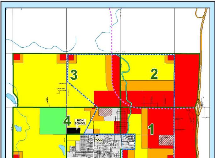
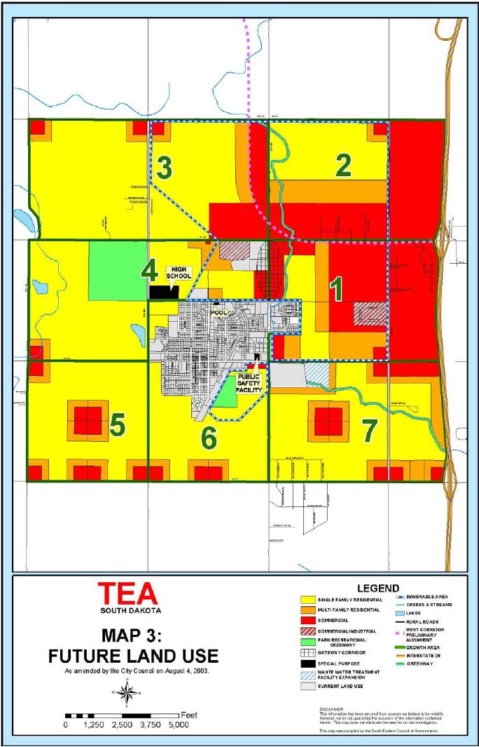
10 Tea Highway 111 Corridor Study CHAPTER 3: TRAFFIC PROJECTIONS 3.1 TEA COMPREHENSIVE PLAN The future land uses for property that will likely become part of the City of Tea has been planned through the Tea Comprehensive Plan. The future land use is shown in Figure FUTURE TRAFFIC VOLUMES (2035) Based on projected growth trends and planned land use in the study area, future year 2035 volumes were developed by HDR using forecast information supplied by the City of Sioux Falls. The City of Sioux Falls planning staff provided output from the regional traffic forecasting model for each scenario. The link volumes for the existing and future base condition are shown in Figure 5. Forecast turning movements and Level of Service for the study area intersections are shown in Figure 6. The levels of service shown in Figure 6 are based on the current lane configurations under 2035 traffic conditions. Levels of Service are covered in more detail in Chapter 4. Lincoln Co. Highway 111 Corridor Study 6
11 FIGURE 4
12 LC 111 N 271ST STREET 2009 VOLUME *24 HOUR = *AM = 749 *PM = VOLUME *24 HOUR = *AM = 1120 *PM = 1540 BRIAN STREET 2009 VOLUME *24 HOUR = 7378 *AM = 545 *PM = VOLUME *24 HOUR = *AM = 800 *PM = 1400 KEVIN DRIVE 2009 VOLUME *24 HOUR = 6431 *AM = 403 *PM = VOLUME *24 HOUR = 9000 *AM = 700 *PM = 1285 FIRST STREET FIGURE AND 2035 LINK VOLUMES Jun 09
13 LEGEND XX (XXX) AM (PM) TRAFFIC VOLUMES LC 111 N B (B) AM LEVEL OF SERVICE (PM) LEVEL OF SERVICE SIGNAL CONTROL STOP CONTROL C (D) (80) (250) (80) (90) 190 (20) 15 (40) 20 (90) (100) (270) (290) (120) (480) (70) (200) (420) 271ST STREET (130) (640) (80) (65) 20 (55) 25 (50) (100) (535) (35) BRIAN STREET F (F) (120) (580) (30) (80) 70 (20) 5 (65) (30) 5 (5) 5 (25) KEVIN DRIVE D (F) (30) (560) (30) (400) (170) (100) C (F) FIRST STREET (270) 180 (40) 30 (50) (10) 10 (55) 5 (10) (120) (340) (30) FIGURE 6 Jun VOLUME AND LEVEL OF SERVICE WITH EXISTING LANES
14 Tea Highway 111 Corridor Study CHAPTER 4: OPERATIONAL ANALYSIS 4.1 ANALYSIS DESCRIPTION Observations of traffic volumes provide an understanding of the general nature of traffic, but are insufficient to indicate either the ability of the street network to carry additional traffic or the quality of service provided by the street system. For this reason the concept of level of service (LOS) was developed to correlate numerical traffic operational data to subjective descriptions of traffic performance at intersections. Each lane of traffic has delay associated with it and therefore a correlating LOS. The weighted average delay for each of these lanes of traffic for a signalized intersection is the intersection LOS. LOS categories range from LOS A (best) to F (worst) as shown in Table 2. TABLE 1. Level of Service Description Level of Service SIGNALIZED Intersection Control Delay (sec) UNSIGNALIZED Intersection Control Delay (sec) Intersection LOS Description A Free flow, insignificant delays. B Stable operation, minimal delays. C Stable operation, acceptable delays. D Restricted flow, regular delays. E Maximum capacity, extended delays. Volumes at or near capacity. Long queues form upstream from intersection. F > 80.0 > 50.0 Forced flow, excessive delays. Represents jammed conditions. Intersection operates below capacity with low volumes. Queues may block upstream intersections. Source: Highway Capacity Manual, Transportation Research Board, 2000 The intersection capacity analyses were completed with Synchro 7.0 software. Synchro replicates the analysis procedures defined in the latest version of the Highway Capacity Manual. This manual provides procedures for the analysis of both signalized and unsignalized intersections. It should be noted that stop-controlled intersections are analyzed by identifying the amount of delay at each approach that conflict with other intersection movements (i.e. all movements except the free flow thru lanes), thus approach LOS is reported for unsignalized intersections. LOS C has generally been established as the standard for planning of transportation facilities for peak hour traffic conditions. However, LOS D is often accepted in urbanized areas where the cost or impacts to provide LOS C is prohibitive. For this study, LOS D for the overall intersection was used as the minimum standard. A review of the analyses for each volume scenario is provided below. Summary LOS output reports of the analyses are included in the Appendix. Lincoln Co. Highway 111 Corridor Study 10
15 Tea Highway 111 Corridor Study EXISTING CONDITIONS ANALYSIS A capacity analysis was performed using the existing A.M. and P.M. peak hour traffic volumes on the existing roadway network. The intersection of LC 111/First Street operates at LOS B during both peak hours. The intersection of LC 111/Kevin Drive operates at LOS C during both peak hours. The intersection of LC 111/Brian Street operates at LOS C during both peak hours. The intersection of LC 111/271 st Street operates at LOS B during both peak hours. The existing peak hour traffic volumes, pedestrian volumes, and levels of service are shown in Figure CONDITIONS ANALYSIS, with no improvements A capacity analysis was performed for the 2035 traffic volumes on the roadway network without any additional roadway improvements. The intersection of LC 111/First Street operates at LOS C in the AM peak hour and LOS F in the PM peak hour. The intersection of LC 111/Kevin Drive operates at LOS D in the AM peak hour and LOS F in the PM peak hour. The intersection of LC 111/Brian Street operates at LOS F in both peak periods. The intersection of LC 111/271 st Street operates at LOS C in the AM peak and LOS D in the PM peak. All study area arterial intersections appear to need improvement to avoid future congestion problems. The 2035 volumes and levels of service are shown in Figure CONDITIONS ANALYSIS, with improvements Capacity analyses were performed using the year 2035 traffic volumes for a network including various lane additions and intersection controls, with the goal of achieving acceptable levels of service. Those analyses were used to prepare the recommended improvements described in Chapter 5. The 2035 recommended improvements are shown in Figure 7. Lincoln Co. Highway 111 Corridor Study 11
16 CHAPTER 5: FINDINGS AND RECOMMENDATIONS Tea Highway 111 Corridor Study This section summarizes the findings and recommendations based upon analysis of future development and traffic conditions. 5.1 GENERAL FINDINGS The general findings and recommendations are as follows: Under the 2009 existing volume scenario all the intersections in the study area operate well during both the A.M. and P.M. peak hours. Under the 2035 volume scenarios, without improvements, all study area intersections appear to need additional lanes or traffic control to operate at acceptable levels. The 2035 link volumes have reached a level that will likely require two through lanes in each direction. The density of development along the corridor and access spacing appears to call for a continuous left-turn lane, resulting in a future 5-lane roadway crosssection. A 4-lane divided cross-section may also be appropriate for portions of the corridor that have remained mostly undeveloped. Traffic control at the study area intersections will need to transition to traffic signal control, with the most likely candidates for signal control being LC 111/First Street and LC 111/Brian Street. Traffic conditions should be monitored and plans should be made for signalization when the intersections meet the traffic signal warrant conditions, as described in the Manual on Uniform Traffic Control Devices (MUTCD). Demand for pedestrian and bicycle service in the corridor is growing due to traveler desire to reach the businesses along the corridor. Federal regulations require that pedestrians and bicyclists be accommodated on all routes that receive Federal funding. 5.2 SPECIFIC FINDINGS & RECOMMENDATIONS The recommendations to mitigate each intersection to LOS C or better in 2035 are listed below. Refer to Figure 7 for a graphic illustration, including needed lane layouts. LC 111/First Street provide additional lanes and underground infrastructure for a future traffic signal. LC 111/Kevin Drive provide additional lanes and underground infrastructure for a future traffic signal. LC 111/Brian Street provide additional lanes and underground infrastructure for a future traffic signal. LC 111/271 st Street provide additional lanes and a permanent traffic signal installation with mast arms and provisions for coordination throughout the corridor. Provisions should be made for pedestrians and bicyclists in the design of improvements on LC 111, within the City of Tea. Options include sidewalks along both sides of the street, widened pedestrian and bicycle side-paths instead of sidewalks, and a combination of sidewalks and on-street bicycle lanes. The City of Brandon recently installed side-paths during reconstruction of Holly Boulevard. Those side-paths appear to be well-accepted by the community. Other similar installations in other states have resulted in safety problems at street intersections. Experienced bicyclists tend to shun side-paths in favor of riding Lincoln Co. Highway 111 Corridor Study 12
17 Tea Highway 111 Corridor Study on the street and prefer bicycle lanes. The type of pedestrian and bicycle improvements designed for LC 111 in Tea should be the subject of community discussion prior to implementation. Lincoln Co. Highway 111 Corridor Study 13
18 LEGEND RECOMMENDED LANE CONFIGURATION LC 111 N SIGNAL CONTROL 271ST STREET BRIAN STREET KEVIN DRIVE FIRST STREET FIGURE RECOMMEND LANES Jun 09
Traffic Impact Analysis Chatham County Grocery Chatham County, NC
 Chatham County Grocery Chatham County, NC TABLE OF CONTENTS 1. INTRODUCTION... 1 1.1. Location and Study Area... 1 1.2. Proposed Land Use and Access... 2 1.3. Adjacent Land Uses... 2 1.4. Existing ways...
TRAFFIC IMPACT STUDY CRITERIA
 Chapter 6 - TRAFFIC IMPACT STUDY CRITERIA 6.1 GENERAL PROVISIONS 6.1.1. Purpose: The purpose of this document is to outline a standard format for preparing a traffic impact study in the City of Steamboat
5858 N COLLEGE, LLC N College Avenue Traffic Impact Study
 5858 N COLLEGE, LLC nue Traffic Impact Study August 22, 2016 Contents Traffic Impact Study Page Preparer Qualifications... 1 Introduction... 2 Existing Roadway Conditions... 5 Existing Traffic Conditions...
Traffic Impact Study WestBranch Residential Development Davidson, NC March 2016
 Traffic Impact Study WestBranch Residential Development Davidson, NC March 216 TRAFFIC IMPACT STUDY FOR THE WestBranch Residential Development LOCATED IN DAVIDSON, NC Prepared For: Lennar Carolinas, LLC
TRANSPORTATION ANALYSIS REPORT US Route 6 Huron, Erie County, Ohio
 TRANSPORTATION ANALYSIS REPORT US Route 6 Huron, Erie County, Ohio December 12, 2012 Prepared for: The City of Huron 417 Main Huron, OH 44839 Providing Practical Experience Technical Excellence and Client
Project Report. South Kirkwood Road Traffic Study. Meadows Place, TX October 9, 2015
 Meadows Place, TX October 9, 2015 Contents 1 Introduction... 1 2 Data Collection... 1 3 Existing Roadway Network... 2 4 Traffic Volume Development... 2 5 Warrant Analysis... 3 6 Traffic Control Alternative
METHODOLOGY. Signalized Intersection Average Control Delay (sec/veh)
") Chapter 5 Traffic Analysis 5.1 SUMMARY US /West 6 th Street assumes a unique role in the Lawrence Douglas County transportation system. This principal arterial street currently conveys commuter traffic
Chapter 5 Traffic Analysis 5.1 SUMMARY US /West 6 th Street assumes a unique role in the Lawrence Douglas County transportation system. This principal arterial street currently conveys commuter traffic
Subject: Solberg Avenue / I-229 Grade Separation: Traffic Analysis
 MEMORANDUM Transportation Bill Troe, AICP Jason Carbee, AICP 12120 Shamrock Plaza Suite 300 Omaha, NE 68154 (402) 334-8181 (402) 334-1984 (Fax) To: Project File Date: Subject: Solberg Avenue / I-229 Grade
TRAFFIC IMPACT ANALYSIS
 TRAFFIC IMPACT ANALYSIS FOR THE CHAMPAIGN UNIT#4 SCHOOL DISTRICT PROPOSED HIGH SCHOOL (SPALDING PARK SITE) IN THE CITY OF CHAMPAIGN Final Report Champaign Urbana Urbanized Area Transportation Study 6/24/2014
Traffic Impact Study. Westlake Elementary School Westlake, Ohio. TMS Engineers, Inc. June 5, 2017
 TMS Engineers, Inc. Traffic Impact Study Westlake Elementary School Westlake, Ohio June 5, 2017 Prepared for: Westlake City Schools - Board of Education 27200 Hilliard Boulevard Westlake, OH 44145 TRAFFIC
Existing Conditions. Date: April 16 th, Dan Holderness; Coralville City Engineer Scott Larson; Coralville Assistant City Engineer
 Date: April 16 th, 2015 To: From: Re: Dan Holderness; Coralville City Engineer Scott Larson; Coralville Assistant City Engineer Darian Nagle-Gamm, Traffic Engineering Planner Highway 6 (2 nd Street) /
Traffic Impact Analysis Walton Acres at Riverwood Athletic Club Clayton, NC
 Traffic Impact Analysis Walton Acres at Riverwood Athletic Club Clayton, NC 1. TABLE OF CONTENTS INTRODUCTION...1 1.1. Site Location and Study Area...1 1.2. Proposed Land Use and Site Access...2 1.3.
TRAFFIC STUDY GUIDELINES Clarksville Street Department
 TRAFFIC STUDY GUIDELINES Clarksville Street Department 9/1/2009 Introduction Traffic studies are used to help the city determine potential impacts to the operation of the surrounding roadway network. Two
TRAFFIC ASSESSMENT River Edge Colorado
 TRAFFIC ASSESSMENT River Edge Colorado Submitted by: Fehr & Peers 621 17th Street, Ste. 231 Denver, CO 8293 (33) 296-43 December, 21 App. M-2 Traffic Assessment River Edge Colorado December 21 TABLE OF
1609 E. FRANKLIN STREET HOTEL TRAFFIC IMPACT STUDY EXECUTIVE SUMMARY
 1609 E. FRANKLIN STREET HOTEL TRAFFIC IMPACT STUDY EXECUTIVE SUMMARY Prepared for: The Town of Chapel Hill Public Works Department Traffic Engineering Division Prepared by: HNTB North Carolina, PC 343
APPENDIXB. Traffic Operations Technical Memorandum
 APPENDIXB Traffic Operations Technical Memorandum Environmental Assessment - Lincoln County, SD 85 th Street: Sundowner Avenue to Louise Avenue November 2017 MEMORANDUM Transportation Jim Kollbaum, PE
DUNBOW ROAD FUNCTIONAL PLANNING
 DUNBOW ROAD FUNCTIONAL PLANNING Final Report August 3, 216 #31, 316 5th Avenue NE Calgary, AB T2A 6K4 Phone: 43.273.91 Fax: 43.273.344 wattconsultinggroup.com Dunbow Road Functional Planning Final Report
TRAFFIC IMPACT STUDY And A TRAFFIC SIGNAL WARRANT ANALYSIS FOR A SENIOR LIVING AND APARTMENT DEVELOPMENT
 TRAFFIC IMPACT STUDY And A TRAFFIC SIGNAL WARRANT ANALYSIS FOR A SENIOR LIVING AND APARTMENT DEVELOPMENT DEERFIELD TOWNSHIP, WARREN COUNTY, OHIO Nantucket Circle and Montgomery Road () Prepared for: ODLE
Waterford Lakes Small Area Study
 Waterford Lakes Small Area Study Existing Traffic Conditions PREPARED FOR: ORANGE COUNTY PUBLIC WORKS DEPARTMENT TRAFFIC ENGINEERING DIVISION ORLANDO, FLORIDA PREPARED WITH: INWOOD CONSULTING ENGINEERS
TRAFFIC IMPACT STUDY COMPREHENSIVE UPDATE TOWN OF THOMPSON S STATION, TENNESSEE PREPARED FOR: THE TOWN OF THOMPSON S STATION
 TRAFFIC IMPACT STUDY COMPREHENSIVE UPDATE TOWN OF THOMPSON S STATION, TENNESSEE PREPARED FOR: THE TOWN OF THOMPSON S STATION Transportation Consultants, LLC 1101 17 TH AVENUE SOUTH NASHVILLE, TN 37212
Chapter 4 Traffic Analysis
 Chapter 4 Traffic Analysis PURPOSE The traffic analysis component of the K-68 Corridor Management Plan incorporates information on the existing transportation network, such as traffic volumes and intersection
Glenn Avenue Corridor Traffic Operational Evaluation
 Glenn Avenue Corridor Traffic Operational Evaluation PREPARED FOR: THE CITY OF AUBURN PREPARED BY: DECEMBER 2007 Glenn Avenue Corridor Study--Auburn, Alabama TABLE OF CONTENTS Introduction... 1 Background
Technical Memorandum TRAFFIC IMPACT STUDY. RIDLEY ROAD CONVENIENCE STORE Southampton County, VA. Prepared for: Mr. David Williams.
 Technical Memorandum TRFFIC IMPCT STUDY RIDLEY ROD CONVENIENCE STORE Southampton County, V Prepared for: Mr. David Williams By: Charles Smith, P.E., PTOE EPR Charlottesville, V July 2014 1 TBLE OF CONTENTS
THIS PAGE LEFT BLANK INTENTIONALLY
 GA SR 25 Spur at Canal Road Transportation Impact Analysis PREPARED FOR GLYNN COUNTY, GEORGIA 1725 Reynolds Street, Suite 300 Brunswick, Georgia 31520 PREPARED BY 217 Arrowhead Boulevard Suite 26 Jonesboro,
Abrams Associates. Transportation Impact Analysis. City of Rocklin. Prepared for: David Mohlenbrok City of Rocklin 4081 Alvis Court Rocklin, CA 95677
 Transportation Impact Analysis Sierra College Boulevard Commercial Project City of Rocklin Prepared for: David Mohlenbrok City of Rocklin 081 Alvis Court Rocklin, CA 95677 Prepared by: 1875 Olympic Boulevard,
VIVA RETIREMENT COMMUNITIES OAKVILLE TRAFFIC IMPACT STUDY
 VIVA RETIREMENT COMMUNITIES OAKVILLE TRAFFIC IMPACT STUDY VIVA RETIREMENT COMMUNITIES OAKVILLE TRAFFIC IMPACT STUDY DECEMBER 2012 READ, VOORHEES & ASSOCIATES TORONTO, ONTARIO Read, Voorhees & Associates
City of Homewood Transportation Plan
 City of Homewood Transportation Plan Prepared for: City of Homewood, Alabama Prepared by: Skipper Consulting, Inc. May 2007 TABLE OF CONTENTS INTRODUCTION... 1 BACKGROUND INFORMATION... 1 EXISTING TRANSPORTATION
ALLEY 24 TRAFFIC STUDY
 ALLEY 24 TRAFFIC STUDY in City of Frostburg, Maryland January 2013 3566 Teays Valley Road Hurricane, WV Office: (304) 397-5508 www.denniscorporation.com Alley 24 Traffic Study January 2013 Frostburg, Maryland
Traffic Impact Study Little Egypt Road Development Denver, North Carolina June 2017
 Traffic Impact Study Little Egypt Road Development Denver, North arolina June 2017 N. Little Egypt Road DQ\ QDQFLQJ VDOHV RU RWKHU SHUIRUPDQFH EDVHG FULWHULD Proposed Site Driveways Site Driveway 1 TRAFFI
Walmart (Store # ) 60 th Street North and Marion Road Sioux Falls, South Dakota
 60 th Street North and Marion Road Sioux Falls, South Dakota") Walmart (Store #4865-00) 60 th Street North and Marion Road Sioux Falls, South Dakota Prepared for: Wal-Mart Stores, Inc. Bentonville, Arkansas Prepared by: Kimley-Horn and Associates, Inc. ã2013 Kimley-Horn
Walmart (Store #4865-00) 60 th Street North and Marion Road Sioux Falls, South Dakota Prepared for: Wal-Mart Stores, Inc. Bentonville, Arkansas Prepared by: Kimley-Horn and Associates, Inc. ã2013 Kimley-Horn
Donahue Drive Corridor Traffic Operational Evaluation
 Donahue Drive Corridor Traffic Operational Evaluation PREPARED FOR: THE CITY OF AUBURN PREPARED BY: JANUARY 2007 Donahue Drive Corridor Study--Auburn, Alabama TABLE OF CONTENTS Introduction... 1 Background
Executive Summary June 2015
 Executive Summary June 2015 Highway 112 Corridor Study Benton and Washington Counties Executive Summary June 2015 Prepared by Transportation Planning and Policy Division Arkansas State Highway and Transportation
Harrah s Station Square Casino
 Transportation Analysis Harrah s Station Square Casino Pittsburgh, Pennsylvania Submitted To: City of Pittsburgh and Pennsylvania Gaming Control Board Prepared By: DKS Associates GAI Consultants December
4. ENVIRONMENTAL IMPACT ANALYSIS 9. TRANSPORTATION AND TRAFFIC
 4. ENVIRONMENTAL IMPACT ANALYSIS 9. TRANSPORTATION AND TRAFFIC 4.9.1 INTRODUCTION The following section addresses the Proposed Project s impact on transportation and traffic based on the Traffic Study
List of Attachments. Location Map... Site Plan... City of Lake Elsinore Circulation Element... City of Lake Elsinore Roadway Cross-Sections...
 List of Attachments Exhibits Location Map... Site Plan... City of Lake Elsinore Circulation Element... City of Lake Elsinore Roadway Cross-Sections... Existing Lane Geometry and Traffic Controls... Existing
SECTION 1 - TRAFFIC PLANNING
 SECTION 1 - TRAFFIC PLANNING 1.1 TRAFFIC OPERATIONS 1.1.1 Roadway Functional Classification The Multnomah County Comprehensive Framework Plan s Policy 34: Trafficways and the Functional Classification
Appendix C. NORTH METRO STATION AREA TRAFFIC IMPACT STATEMENT 88th Avenue Station
 Appendix C NORTH METRO STATION AREA TRAFFIC IMPACT STATEMENT 88th Avenue Station Prepared for: Regional Transportation Department and URS Corporation as part of the North Metro EIS David Evans and Associates,
ENHANCED PARKWAY STUDY: PHASE 2 CONTINUOUS FLOW INTERSECTIONS. Final Report
 Preparedby: ENHANCED PARKWAY STUDY: PHASE 2 CONTINUOUS FLOW INTERSECTIONS Final Report Prepared for Maricopa County Department of Transportation Prepared by TABLE OF CONTENTS Page EXECUTIVE SUMMARY ES-1
5.3 TRAFFIC, CIRCULATION AND PARKING
 5.3 TRAFFIC, CIRCULATION AND PARKING This section is based upon the Downtown Lancaster Specific Plan Traffic Impact Analysis (April 2, 2008) and the Downtown Lancaster Specific Plan Parking Analysis (May
SELECTED ROADWAY CAPACITY ANALYSIS
 CHAPTERFOUR SELECTED ROADWAY CAPACITY ANALYSIS 4.1 SELECTED ROADWAY CAPACITY ANALYSIS Introduction Capacity analysis was performed on six selected roadways within the Dearborn County study area using the
Highway 49, Highway 351 and Highway 91 Improvements Feasibility Study Craighead County
 Highway 49, Highway 351 and Highway 91 Improvements Feasibility Study Craighead County Executive Summary March 2015 Highway 49, Highway 351 and Highway 91 Improvements Feasibility Study Craighead County
EXECUTIVE SUMMARY. Page 1 of 6
 EXECUTIVE SUMMARY The purpose of this report is to identify conformance with the original traffic impact study for the proposed retail development on Lot 5 of Riverdale Retail Filing No. 1 located on the
Road Conversion Study Plumas Street
 Plumas Street Phase I Submitted to The Regional Transportation Commission of Washoe County Submitted by Zong Tian, Ph.D., P.E. Saeedeh Farivar Haiyuan Li, Ph.D. Center for Advanced Transportation Education
Simulating Street-Running LRT Terminus Station Options in Dense Urban Environments Shaumik Pal, Rajat Parashar and Michael Meyer
 Simulating Street-Running LRT Terminus Station Options in Dense Urban Environments Shaumik Pal, Rajat Parashar and Michael Meyer Abstract The Exposition Corridor transit project is a light rail project
Shockoe Bottom Preliminary Traffic and Parking Analysis
 Shockoe Bottom Preliminary Traffic and Parking Analysis Richmond, Virginia August 14, 2013 Prepared For City of Richmond Department of Public Works Prepared By 1001 Boulders Pkwy Suite 300, Richmond, VA
7 th Street Bike Lane Traffic Impact Study
 7 th Street Bike Lane Traffic Impact Study Submitted by: San Francisco Department of Parking and Traffic Michael Sallaberry June 11, 2001 EXECUTIVE SUMMARY This report presents the Department of Parking
5.0 Roadway System Plan
 Southwest Boise Transportation Study Page 16 5.0 Roadway System Plan The Roadway System Plan outlines roadway improvements in the Initial Study Area. It forecasts future deficiencies on the arterial system,
Chapter 16: Traffic and Parking A. INTRODUCTION
 Chapter 6: Traffic and Parking A. ITRODUCTIO This chapter examines the potential traffic and parking impacts of the proposed Fresh Kills Park roads. The analysis of transit and pedestrians is presented
Traffic Circulation Study for Neighborhood Southwest of Mockingbird Lane and Airline Road, Highland Park, Texas
 ARIZONA TEXAS NEW MEXICO OKLAHOMA February 13, 2015 Mr. Meran Dadgostar P.E., R.S. Town of Highland Park 4700 Drexel Dr. Highland Park, Texas 75205 Re: Traffic Circulation Study for Neighborhood Southwest
Clackamas County Comprehensive Plan
 ROADWAYS The County s road system permits the movement of goods and people between communities and regions, using any of a variety of modes of travel. Roads provide access to virtually all property. They
3.9 - Transportation and Traffic
 Transportation and Traffic 3.9 - Transportation and Traffic This section describes the potential transportation and traffic effects of project implementation on the project site and its surrounding area.
Frequently Asked Questions
 Frequently Asked Questions Business US 190 in Copperas Cove From Avenue D to Constitution Drive What is access management? A. Access Management is a growing effort by government agencies to improve how
Walton Acres at Riverwood Athletic Club Clayton, North Carolina
 9. CONCLUSIONS This Traffic Impact Analysis Update was conducted to determine the potential traffic impacts of the proposed Walton Acres at Riverwood Athletic Club residential development, located east
Evaluation of M-99 (Broad Street) Road Diet and Intersection Operational Investigation
 Road Diet and Intersection Operational Investigation") Evaluation of M-99 (Broad Street) Road Diet and Intersection Operational Investigation City of Hillsdale, Hillsdale County, Michigan June 16, 2016 Final Report Prepared for City of Hillsdale 97 North Broad
Evaluation of M-99 (Broad Street) Road Diet and Intersection Operational Investigation City of Hillsdale, Hillsdale County, Michigan June 16, 2016 Final Report Prepared for City of Hillsdale 97 North Broad
Traffic Impact Study. Roderick Place Columbia Pike Thompson s Station, TN. Transportation Group, LLC Traffic Engineering and Planning
 F i s c h b a c h Transportation Group, LLC Traffic Engineering and Planning Traffic Impact Study Roderick Place Columbia Pike Thompson s Station, TN Prepared March 2016 Ms. Gillian L. Fischbach, P.E.,
Simons Run Corridor Study
 Simons Run Corridor Study Campbell County & City of Lynchburg, Virginia Prepared on: September 30, 2014 Prepared for: Central Virginia Metropolitan Planning Organization 277 Bendix Road, Suite 500 Virginia
9 Leeming Drive Redevelopment Ottawa, ON Transportation Brief. Prepared By: Stantec Consulting Ltd.
 9 Leeming Drive Redevelopment Ottawa, ON Transportation Brief Prepared By: Stantec Consulting Ltd. TIA GUIDELINES CHECKLIST Report Context Municipal Address Comment: Section 1.1 Location relative to major
DRAFT. Corridor study. Honeysuckle Road. October Prepared for the City of Dothan, AL. Prepared by Gresham, Smith and Partners
 DRAFT Corridor study Honeysuckle Road October 2017 Prepared for the City of Dothan, AL Prepared by TABLE OF CONTENTS SECTION I... 1 STUDY SUMMARY... 1 INTRODUCTION... 1 CONCLUSIONS... 5 SECTION II... 7
Route 7 Corridor Study
 Route 7 Corridor Study Executive Summary Study Area The following report analyzes a segment of the Virginia State Route 7 corridor. The corridor study area, spanning over 5 miles in length, is a multi
Appendix B: Forecasting and Traffic Operations Analysis Framework Document
 Existing Conditions Report - Appendix Appendix B: Forecasting and Traffic Operations Analysis Framework Document This document defines the methodology and assumptions that will be used in the traffic forecasting
TRAFFIC IMPACT STUDY. Creekside Thornton, Colorado. For. August 2015 November 2015 Revised: August Prepared for:
 TRAFFIC IMPACT STUDY For Creekside Thornton, Colorado August 215 November 215 Revised: August 216 Prepared for: Jansen Strawn Consulting Engineers 45 West 2 nd Avenue Denver, Colorado 8223 Prepared by:
Magnolia Place. Traffic Impact Analysis. Prepared for: City of San Mateo. Prepared by: Hexagon Transportation Consultants, Inc.
 Magnolia Place Traffic Impact Analysis Prepared for: City of San Mateo Prepared by: Hexagon Transportation Consultants, Inc. Updated January 4, 2010 Table of Contents 1. Introduction...1 2. Existing Conditions...6
Grant Avenue Streetscape
 REPORT TYPE GOES HERE Grant Avenue Streetscape PREPARED FOR City of Manassas 9027 Center Street Manassas, VA 20110 PREPARED BY 8300 Boone Boulevard Suite 700 Vienna, Virginia 22182 571.389.8121 July 31,
ADOT Statewide Bicycle and Pedestrian Program Summary of Phase IV Activities APPENDIX B PEDESTRIAN DEMAND INDEX
 ADOT Statewide Bicycle and Pedestrian Program Summary of Activities APPENDIX B PEDESTRIAN DEMAND INDEX May 24, 2009 Pedestrian Demand Index for State Highway Facilities Revised: May 29, 2007 Introduction
FINAL DESIGN TRAFFIC TECHNICAL MEMORANDUM
 FINAL DESIGN TRAFFIC TECHNICAL MEMORANDUM July 2014 FINAL (SR 43) Project Development and Environment Study From State Road 60 (Adamo Drive) to I-4 (SR 400) Hillsborough County, Florida Work Program Item
Lyons Avenue/Dockweiler Road Extension Project Draft Environmental Impact Report. Appendix I Traffic Impact Study
 Lyons Avenue/Dockweiler Road Extension Project Draft Environmental Impact Report Appendix I Traffic Impact Study Street 0 80-1947 500.4501 RITA ld Court 0 91355-1096 400.7401 LA n Avenue 0 590-3745 300-9301
#!! "$% ##! &! # '#! % $ #!
 Executive Summary US Highway 16 (US 16) is the primary corridor connecting Rapid City to the Black Hills region. It serves a growing population of commercial and residential traffic, as well as seasonal
Angie Silva Kitsap County Commissioners Office Stef Herzstein, PE, PTOE Transpo Group Jessica Lambert Transpo Group
 DRAFT MEMORANDUM Date: September 30, 2016 TG: 16125.00 To: From: cc: Subject: Angie Silva Kitsap County Commissioners Office Stef Herzstein, PE, PTOE Transpo Group Jessica Lambert Transpo Group Erik Rundell
DIMARCO CANANDAIGUA PROPERTIES HOUSING PROJECT CANANDAIGUA, ONTARIO COUNTY, NEW YORK
 TRAFFIC IMPACT STUDY FOR THE DIMARCO CANANDAIGUA PROPERTIES HOUSING PROJECT CANANDAIGUA, ONTARIO COUNTY, NEW YORK MARCH 14, 2017 PREPARED FOR: 1950 Brighton Henrietta Town Line Rd Rochester, NY 14623 PREPARED
USA Parkway Traffic Operations Analysis, Roundabout Option. Pedro Rodriguez, NDOT; Bryan Gant, Jacobs; Randy Travis, NDOT
 Technical Memorandum TO: Hoang Hong, NDOT DATE: September 21, 2012 FROM: SUBJECT: COPIES: John Karachepone, Jacobs USA Parkway Traffic Operations Analysis, Pedro Rodriguez, NDOT; Bryan Gant, Jacobs; Randy
AMEC Earth and Environmental. Bovaird Drive Environmental Assessment. Traffic Study Final Report. August Excellence in Transportation Planning
 AMEC Earth and Environmental Bovaird Drive Environmental Assessment Traffic Study Final Report August Excellence in Transportation Planning AMEC Earth and Environmental Bovaird Drive Class EA Traffic
APPENDIX G: INTERSECTION NEEDS AT OKEECHOBEE BOULEVARD
 APPENDIX G: INTERSECTION NEEDS AT OKEECHOBEE BOULEVARD INTERSECTION NEEDS AT SR 7 and OKEECHOBEE BOULEVARD SR 7 Extension Project Development and Environment (PD&E) Study From Okeechobee Boulevard (SR
Traffic Impact Analysis (TIA) Process and Procedures Manual. September 2017
 Process and Procedures Manual. September 2017") Traffic Impact Analysis (TIA) Process and Procedures Manual Post Office Box 664 101 Huntersville-Concord Road Huntersville, NC 28070 Phone 704-766-2220 Fax 704-992-5528 www.huntersville.org (c) 2017, Town
Traffic Impact Analysis (TIA) Process and Procedures Manual Post Office Box 664 101 Huntersville-Concord Road Huntersville, NC 28070 Phone 704-766-2220 Fax 704-992-5528 www.huntersville.org (c) 2017, Town
TABLE OF CONTENTS TABLE OF CONTENTS... I APPENDICES... III LIST OF EXHIBITS... V LIST OF TABLES... VII LIST OF ABBREVIATED TERMS...
 TABLE OF CONTENTS TABLE OF CONTENTS... I APPENDICES... III LIST OF EXHIBITS... V LIST OF TABLES... VII LIST OF ABBREVIATED TERMS... IX 1 INTRODUCTION... 1 1.1 Project Overview... 1 1.2 Analysis Scenarios...
Transportation Impact Study for Abington Terrace
 Transportation Impact Study for Abington Terrace Abington Township, Montgomery County, PA Sandy A. Koza, P.E., PTOE PA PE License Number PE059911 Prepared by McMahon Associates, Inc. 425 Commerce Drive,
Traffic Academy: IJS & IMS FAQ/RULES OF THUMB
 FAQ/RULES OF THUMB HCS intersection analysis criteria See LDM Figure 401-14aE Cycle lengths between 60 to 120 seconds No impractical phases, i.e., 1 second green time Yellow + All Red must be no less than
TAKOMA METRO STATION
 TKOM METRO STTION Traffic nalysis Technical Memorandum Station Planning in Support of Joint evelopment Job No. 13-FQ165-LN-2 November 213 WSHINGTON METROPOLITN RE TRNSIT UTHORITY (WMT) Takoma Metro Station
The current document is revised based on the comments received on:
 General Overview 1 Introduction Over the last several years, the Waterford Lakes area has experienced increased congestion due to a substantial increase in residential and commercial development. The current
Planning Guidance in the 2012 AASHTO Bike Guide
 Planning Guidance in the 2012 AASHTO Bike Guide Presentation by: RJ Eldridge Peter Lagerwey August 22, 2012 WEBINAR 2: PLANNING GUIDANCE IN THE 2012 AASHTO BIKE GUIDE Today s Webinar Significant Updates
QUICKIE C STORE AND GAS BAR 1780 HERON ROAD OTTAWA, ONTARIO TRANSPORTATION BRIEF. Prepared for:
 QUICKIE C STORE AND GAS BAR 1780 HERON ROAD OTTAWA, ONTARIO TRANSPORTATION BRIEF Prepared for: Quickie Convenience Stores Larny Holdings Ltd. c/o PBC Group April 15, 2015 115-615 Report_1.doc D. J. Halpenny
Access Management Regulations and Standards for Minor Arterials, Collectors, Local Streets
 Access Management Regulations and Standards for Minor Arterials, Collectors, Local Streets September 2009 Paul Grasewicz Access Management Administrator Concept of Access Management The way to manage access
FRONT RANGE CROSSINGS TRAFFIC IMPACT STUDY
 FRONT RANGE CROSSINGS TRAFFIC IMPACT STUDY Prepared for: City of Thornton And Colorado Department of Transportation Prepared by: 11 Blake Street, Suite 2 Denver, Colorado 822 Contact: Brian Bern, PE, PTOE
STILLWATER AVENUE CORRIDOR STUDY Old Town, Maine
 Draft Study STILLWATER AVENUE CORRIDOR STUDY Old Town, Maine SUBMITTED TO: BANGOR AREA COMPREHENSIVE TRANSPORTATION SYSTEM SUBMITTED BY: I MAY 23, 2017 DRAFT STILLWATER AVENUE STUDY FINAL REPORT Table
Bistro 6. City of Barrie. Traffic Impact Study for Pratt Hansen Group Inc. Type of Document: Final Report. Project Number: JDE 1748
 City of Barrie Traffic Impact Study for Pratt Hansen Group Inc. Type of Document: Final Report Project Number: JDE 1748 Date Submitted: June 12 th, 2017 06/12/17 John Northcote, P.Eng. Professional License
TRAFFIC IMPACT STUDY
 TRAFFIC IMPACT STUDY for the GLEN ELLEN COUNTRY CLUB SENIOR RESIDENTIAL REDEVELOPMENT 84 Millis, Massachusetts Prepared by: McMahon Associates, Inc. Prepared for: Toll Brothers, Inc. August 216 DRAFT
Low Level Road Improvements Traffic Analysis. Report
 Low Level Road Improvements Traffic Analysis Report June, 22 Table of Contents. INTRODUCTION.... LOW LEVEL ROAD PROJECT....2 STUDY AREA....2. West-End Corridor Improvements... 2.2.2 East-End Corridor Improvements...
Intersection Traffic Control Feasibility Study
 Intersection Traffic Control Feasibility Study CSAH 9 at CSAH 60 (185th Avenue) Prepared For: Dakota County Transportation Department Western Service Center 14955 Galaxie Avenue, 3rd Floor Apple Valley,
Figure 1: East West Connector Alignment Alternatives Concept Drawing
 Page 2 of 9 Figure 1: East West Connector Alignment Alternatives Concept Drawing The Montebello Drive extension will run north south and connect Wilsonville Road to the Boones Ferry Road to Brown Road
Feasibility Study of Pedestrian Crossings Along Route 7, East of Cascades Parkway and West of Dranesville Road. October 3, 2017
 Feasibility Study of Pedestrian Crossings Along Route 7, East of Cascades Parkway and West of Dranesville Road October 3, 2017 Study Area (area within a ¼-mile radius of the study intersections) Route
Bridge Street Corridor Study Report
 Bridge Street Corridor Study Report Prepared for: Prepared by: BRIDGE STREET CORRIDOR STUDY REPORT PREPARED FOR: CITY OF ARROYO GRANDE COMMUNITY DEVELOPMENT DEPARTMENT 300 EAST BRANCH STREET ARROYO GRANDE,
OTTAWA TRAIN YARDS PHASE 3 DEVELOPMENT CITY OF OTTAWA TRANSPORTATION IMPACT STUDY. Prepared for:
 OTTAWA TRAIN YARDS PHASE 3 DEVELOPMENT CITY OF OTTAWA TRANSPORTATION IMPACT STUDY Prepared for: The Ottawa Train Yards Inc. 223 Colonnade Road South, Suite 212 Nepean, Ontario K2E 7K3 January 17, 2012
MEMORANDUM. Our project study area included the following locations:
 MEMORANDUM Date: To: From: Subject: Najib O. Habesch Nick M. Fomenko, PE, PTOE Bushnell Park North Traffic Assessment BETA Project #: 4461 As part of our contract to undertake the design of the Bushnell
Traffic Study North Shore School District 112
 Traffic Study North Shore School District 112 Proposed Expansion of Northwood Junior High School Prepared By: May 1, 2015 1. Introduction Kenig, Lindgren, O Hara, Aboona, Inc. (KLOA, Inc.) has been retained
This page intentionally left blank.
 This page intentionally left blank. COMMUNITY Glenpool Community Overview Glenpool Glenpool is a city of nearly 12,000 residents located in Tulsa County southwest of Tulsa and Jenks. The city is growing
Traffic Analysis and Design Report. NW Bethany Boulevard. NW Bronson Road to NW West Union Road. Washington County, Oregon
 Traffic Analysis and Design Report NW Bethany Boulevard NW Bronson Road to NW West Union Road Washington County, Oregon May 2011 Table of Contents Table of Contents Section 1 Executive Summary... 2 Section
Sixth Line Development - Transit Facilities Plan
 Memorandum Date: November 13, 2012 To: From: c.c. Subject: Rob Freeman (Freeman Planning) Kevin Phillips Sixth Line Development - Transit Facilities Plan 33016631 This memo was prepared to review the transit
Access Management Regulations and Standards
 Access Management Regulations and Standards Efficient highway operation Reasonable property access Concept of Access Management The way to manage access to land development while simultaneously preserving
Gateway Transportation Study
 Gateway Transportation Study Amherst, Massachusetts SUBMITTED TO University of Massachusetts Amherst Town of Amherst SUBMITTED BY Vanasse Hangen Brustlin, Inc. Watertown, Massachusetts March 213 Back of
FINAL Albertville Business Park AUAR Update Traffic Study
 FINAL Albertville Business Park AUAR Update Traffic Study Prepared for City of Albertville, MN July 20, 2017 SRF No. 10060.00 Table of Contents Introduction... 1 Existing Conditions... 1 Data Collection...
Design Traffic Technical Memorandum
 State Road 7 Extension PD&E Study Design Traffic Technical Memorandum Palm Beach County, FL October 2010 State Road 7 Extension PD&E Study Design Traffic Technical Memorandum Palm Beach County, FL Prepared