M-58 HIGHWAY ACCESS MANAGEMENT STUDY Mullen Road to Bel-Ray Boulevard. Prepared for CITY OF BELTON. May 2016
|
|
|
- Christiana Johnson
- 5 years ago
- Views:
Transcription

1 M-58 HIGHWAY ACCESS MANAGEMENT STUDY Prepared for CITY OF BELTON By May 2016
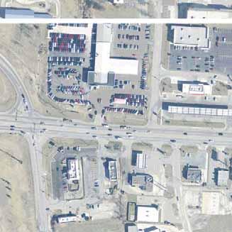
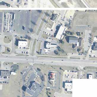
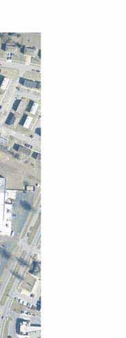
2 Introduction Missouri State Highway 58 (M-58 Highway) is a major commercial corridor in the City of Belton. As development has increased along the corridor, traffic volumes have increased and traffic flow is congested at peak times; due in part to the number of closely spaced intersections commercial driveways. Intersections and driveways are typically the locations where vehicular conflicts and crashes are most prevalent. City staff has concerns about traffic flow and safety along the corridor. In light of these concerns, City staff authorized TranSystems to prepare the following study to identify improvements to manage access along the corridor more effectively to reduce conflicts and improve operations. Study Area The Missouri Department of Transportation (MoDOT) classifies M-58 Highway as a minor arterial roadway, which provides access to the regional highway system via a diamond interchange with I-49. The posted speed limit on M-58 Highway is 40 mph. M-58 Highway has a five-lane cross section, which includes a center two-way left-turn lane and two through lanes in each direction. The width of M-58 Highway varies between 64 and 62 feet, measured between the back of curbs. The through lanes are generally 11 feet in width, and the center turn lane is roughly 14 feet in width. The roadway has curb and gutters and sidewalks along each side. The study segment of M-58 Highway from is shown on Figure A-1 in the Appendix. TranSystems conducted traffic counts on M-58 Highway west of Powell Parkway as part of the traffic impact study for the proposed NEWCO development. The average daily traffic volume on a typical weekday is 28,531. According to MoDOT s 2013 traffic count map, the average daily traffic volume on M-58 Highway east of I-49 is 30,048. Traffic Control and Access There are a number of driveways and intersections along the study segment of M-58 Highway as indicated in Table 1 below. Many of these are spaced closely together. In the roughly 1/2 mile segment between Mullen Road and I-49 there are 10 driveways and intersections. There are 15 total driveways and intersections in the 1/3 mile segment between I-49 and Bel-Ray Boulevard. Many of these do not align with access points across M-58 Highway, resulting in offsets between intersections. Figure 1 illustrates the location of the existing access points along the corridor as well as the existing traffic controls and turn restrictions. Street Segment Table 1 M-58 Highway Access Density Segment Length Number of Access Points Access Points Per Mile Mullen Road to I-49 2,350 Feet to Bel-Ray Boulevard 1,800 Feet Mullen Road to Bel-Ray Boulevard 4,150 Feet The traffic impact study for the NEWCO development documented that the five existing signalized intersections between Powell Parkway and the East Outer Road generate queues that spill through adjacent signalized intersections at peak times. Extensive queuing is of concern because it results in congestion, delays, and an increased frequency of rear end crashes. M-58 Highway Access Management Study Belton, Missouri Page 1


3
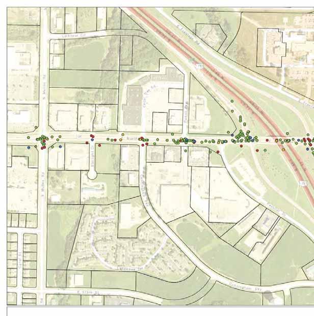
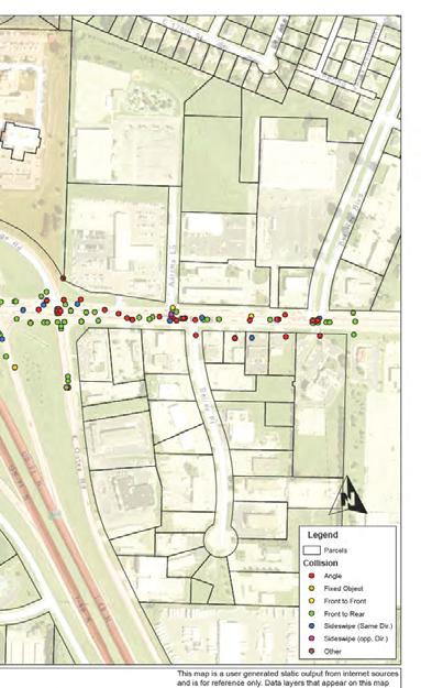
4 Land Uses Nearly all of the land uses along the corridor are commercial businesses. This is consistent with Belton s future land use map. There are currently vacancies in several of the larger shopping centers in the study area. Several small professional offices are also located along M-58 Highway to the east of I-49. There are some light industrial type developments along Bel-Ray Place, south of M-58 Highway. The names of the businesses in the study area are identified on Figure A-1 in the Appendix. Many of the smaller parcels have individual driveways that access M-58 Highway. These driveways typically have short throat lengths between the street and the parking lots. Some of the larger shopping center developments have longer throat lengths. Proposed Development There are several new restaurant developments under construction in the study area to the west of I-49. A Freddie s restaurant is under construction to the west of Bank of America on the north side of M-58 Highway. Longhorn Steakhouse is being constructed along Peculiar Drive adjacent to the EconoLodge. The NEWCO development is proposed along the south side of M-58 Highway between Powell Parkway and I-49. The proposed development plan includes new pad sites and a renovation of part of the existing North Cass Center. The development plan also includes realignment of Peculiar Drive through the existing parking lots to intersect with Powell Parkway south of M-58 Highway. The existing signalized intersection of M-58 Highway and Peculiar Drive would be eliminated. An operational assessment of the proposed development was discussed in the NEWCO traffic impact study. Crash Experience Crash statistics were obtained from the City for the study segment for the time period between January 1, 2013, and February 29, Over this 39-month time period, 379 crashes were reported. This corresponds to a crash rate of 14.1 crashes per million vehicle miles traveled (crashes/mvmt) along the study segment of M-58 Highway. For comparison purposes, a typical crash rate for five-lane undivided urban roadways is between 5 and 7 crashes/mvmt. The locations of the crashes and types of crashes are illustrated in Figure A-2 in the Appendix. The types of crashes that occurred are summarized in Table 2. Crash Type Table 2 M-58 Highway Crash Statistics 2013 Present Property Damage Injury Fatality Total Front-to-Rear Angle Sideswipe Front-to-Front Fixed Object Other Total The most common crash type that occurred along the corridor is Front-to-Rear (rear end) crashes. Rear end collisions are the most common crash type at signalized intersections, and the crash location map indicates that the rear end crashes are clustered near the signalized intersections. There is a particularly large cluster of 105 rear end crashes in the area between Powell Parkway and I-49. Similarly, there are 66 rear end crashes between I-49 and East Outer Road. These are the areas where the M-58 Highway Access Management Study Belton, Missouri Page 3
5 signalized intersections are closely spaced and queues spill back between intersections during peak times. This situation can result in a higher frequency of rear end crashes. Angle crashes occur when vehicles moving perpendicular to each other collide, and they are generally one of the more severe crash types. This is evidenced by the data, which indicates that 40 percent of the angle crashes that occurred during the study period resulted in a personal injury or fatality. Of particular concern is the high number of angle collisions along M-58 Highway. In general, the angle crashes appear to have occurred at intersection or driveway locations. The majority of the angle crashes (62 percent) occurred east of I-49, where there is a higher number of intersections and driveways. Analysis The study segment of M-58 Highway experiences a crash rate that is nearly twice as high as a typical five-lane roadway. Congestion and delays are common along this heavily traveled commercial corridor. These conditions are due in part to a high density of access points that are closely spaced along the study segment. Each of these access points introduces potential for conflicts along the corridor. Given these concerns, access management strategies should be considered for the M-58 Highway corridor to improve safety and operations. Access Management The vehicular traffic concerns identified above for the study segment are related to access management. Access management is a comprehensive view of property access relative to the function of the streets from which it is provided. The objective of access management is to optimize, or find that right balance, between property access and traffic safety and efficiency, particularly along arterial streets. Access management involves careful planning and design of driveways, median openings, interchanges, and street connections to a roadway. It also involves the application of median treatments and turning lanes, and the appropriate separation of traffic signals. Studies to date indicate that effective access management can result in decreased crash frequency, decreased travel time and congestion, increased roadway capacity, increased economic growth, and improved air quality. On routes where access is not managed, increased congestion can lead to a drop in business revenues and property values as motorist avoid the delays on congested routes. The degree of impact will vary based on the specific circumstances of the street segment, but this experience has provided valuable insight into the factors that have a negative influence on traffic safety and efficiency. Some of these factors include: Driveways or side streets in close proximity to intersections; Driveways or side streets spaced too close together; Short throat lengths for driveways; Deceleration of turning traffic in through lanes; and Traffic signals too close together. The following paragraphs identify some applications of using access management principles to address the identified areas of concern for the study segment. Intersection Spacing Access points introduce conflicts and friction into the traffic stream. Vehicles entering and leaving the main roadway often slow the through traffic, and the difference in speeds between through and turning traffic increases accident potential. The consensus is that increasing the spacing between access points improves arterial flow and safety by reducing the number of conflicts per mile, by providing greater distance to anticipate and recover from turning maneuvers, and by providing opportunities for use of turn lanes. Many studies have shown that driveway spacing is one of the key factors that influence crashes. The MoDOT Access Management Guidelines present several desirable spacings for minor arterial roadways. These spacings are shown on the following page in Table 3. M-58 Highway Access Management Study Belton, Missouri Page 4

6 Table 3 MoDOT Access Spacing Guidelines Spacings Along Urban MoDOT Recommendation Minor Arterials Interchange Ramps Between Public Road Intersections Between Traffic Signals 750 Feet to the first Right-In/Right-Out access 1,320 Feet to the first full access intersection 1,320 Feet 2,640 Feet Between Driveways 330 Feet 165 Feet for Right-In/Right-Out access When comparing the recommendations shown in Table 3 to the study segment, it is evident that many of the existing spacings are much less that the recommendations. The existing distances from ramps to the first full access intersections are only 300 feet. The maximum distance between any two adjacent traffic signals is 1,400 feet, which is well short of the recommendations. There are a number of full access driveways, especially east of I-49, which are less than 150 feet apart. This is the same section of the corridor where there is a high concentration of angle crashes. It is often not be possible to incorporate and attain all of the access management guidelines in a retrofit project along an existing corridor. This is due to existing development, economic, physical, and other constraints. In such situations, reasonable solutions should be pursued, through public involvement and cooperation with property owners. Modifications to the street network to should be pursued to improve spacings at key locations. Increased spacing would be most beneficial at the signalized outer road intersections adjacent to the I-49 ramps. Full access intersections and driveways should also be lined up across the public roadway from each other whenever possible, such as at Bel-Ray Circle and Bel-Ray Place. Access should be consolidated or restricted to right-in/right out at the closely spaced full access driveways. Raised Medians Raised medians are the most effective access management strategy on high-volume urban routes. Studies have shown that roadways with raised medians have lower crash rates than multi-lane undivided sections and two-way left-turn lane cross sections. The MoDOT Access Management Guidelines recommend raised medians where current and projected traffic volume is greater than 28,000 vehicles per day. Raised medians are especially recommended in corridors where the density of commercial driveways is high (over 24 per mile in both directions). Raised medians should be installed along M-58 Highway, because these conditions exist on the study segment. The existing center two-way left-turn lane on M-58 Highway is 14 feet wide. This width will allow for a raised median to be constructed where a left-turn lane is not needed. However, where left-turn lanes are needed at intersections, a raised median cannot be provided. The left-turn lane should be at least 11 feet wide, which does not leave enough remaining width for an adequate raised median. Where there are driveways located within areas where leftturn lanes are needed, other devices are necessary to provide the type of access restriction that a median would M-58 Highway Access Management Study Belton, Missouri Page 5
7 otherwise provide. Tubular markers can be used to create the effect of a raised median. Tubular markers are flexible posts that can be installed on the road surface as shown in the image on the previous page. If hit by a vehicle, the marker is likely to require replacement, so tubular markers can require frequent maintenance. Turn Lanes Vehicle slowing to turn disrupt through traffic and can result in increased crashes. Thus it is important to provide turn lanes to store queues and separate turning traffic from through traffic. Left-turn lanes are currently provided along M-58 Highway and should continue be included at all median openings. Left-turn lanes should be sized to allow for adequate storage plus appropriate tapers. To improve efficiency of traffic flow along the corridor, additional length should be considered to accommodate deceleration in the turn lane when possible. Right-turn lanes are recommended in the MoDOT guidelines when the right-turn volume during a peak hour is 70 or more for a posted speed limit of 40 mph. Right-turn lanes should also be long enough to allow for some deceleration in the turn lane. Short-Term Improvements Concept Relocating intersections to achieve more desirable spacings will have significant impacts on the study area and will take some time to implement. A phased strategy is needed to implement access management in the short-term and long-term. Short-term improvements would include more localized improvements at individual access points, while long-term improvements would focus on the surrounding street network. The short-term improvements are illustrated in Figure 2 and described in the following paragraphs. Several new raised medians are shown on Figure 2, especially west of I-49. To the east of I-49 there are more left-turn lanes and fewer opportunities to construct raised medians. Where raised medians cannot be constructed, but driveways are present, tubular markers are proposed to be installed along the centerline in order to restrict left-turn movements into and out of these driveways. Raised medians would be the highest priority of the short-term improvements, as they are likely to have the most significant safety impacts. Medians will restrict left-turn access at several locations and will require some of the other short-term improvements to provide alternate access. Figure 2 illustrates several driveways that are to be removed. At Walgreen s there is an existing driveway at the northwest corner of the site that is too close to Mullen Road. Also the right-turn out movement from Walgreens onto M-58 Highway is within the functional area of the Mullen Road intersection. A driveway to the car wash on Mullen Road, just south of M-58 is also to be removed as it is within close proximity to the M-58 Highway intersection. Two new street connections are shown on the west end of the study area to improve circulation and access by providing these properties with alternate routes to Mullen Road. A number of driveways are also proposed to be removed along M-58 Highway near Bel-Ray Place. The properties affected by driveway closures are to be linked to adjacent properties in order to share access points. This will require some new connections between parking areas. Access easements may also be required for shared access to be implemented. Driveway closures and shared access would be a second priority to improve access management along the corridor. New right-turn lanes are shown on Figure 2 at locations where the right-turn volume is anticipated to be 70 or more during a peak hour. The addition of right-turn lanes at signalized intersections is likely to require traffic signal modifications, as signal poles, controllers, and other equipment could be in conflict with the pavement widening. Right-turn lanes would be the lowest priority of the short-term improvements. M-58 Highway Access Management Study Belton, Missouri Page 6


8
9 Long-Term Improvements Concepts More significant modifications to the street network should be considered in the long-term to improve intersection and traffic signal spacings along the M-58 Highway corridor. TranSystems developed several options which are shown on Figures A-3 to A-5 in the Appendix, and described in the following paragraphs. Option 1 Relocate East Outer Road and Realign Bel-Ray Place The intent of the first option shown on Figure A-3 in the Appendix is to eliminate the signalized intersections that are within 300 feet of the I-49 ramps. Peculiar Drive is to be realigned to intersect Powell Parkway, as is shown in the NEWCO traffic impact study. The realigned roadway is shown continuing to the west to intersect Cunningham Industrial Parkway and Starlight Drive. This will form a backage road to improve circulation for the properties on the south side of M-58 Highway. A connection is also shown between Cunningham Industrial Parkway and 173rd Street. New street connections are also shown on the north side of M-58 Highway, linking Powell Parkway and Larkspur Circle. Powell Parkway is to remain as the location of the first signalized intersection to the west of the I-49 interchange. Traffic signal spacing would be better if the signalized intersection was located at Cunningham Industrial Parkway, rather than Powell Parkway. However, there is no ability to extend Cunningham Industrial Parkway to the north without major changes to the Cedar Tree Center. Immediately north of M-58 Highway, the driveway becomes a drive aisle in the parking lot adjacent to the front doors of several businesses. On the east side of I-49, the East Outer Road is shown to be realigned to follow Bel-Ray Place and intersection M-58 Highway at Bel-Ray Circle. A signalized intersection is shown on M-58 Highway at Bel-Ray Circle, and the existing East Outer Road intersection would provide right-in/right-out access only. A new east/west backage road is shown on the north side of M-58 Highway. A new access road is shown on the south side of M-58 Highway, to connect existing East Outer Road to Bel-Ray Place to provide a route to the full access intersection on M-58 Highway. It should be noted that Bel-Ray Place was likely not designed for the type of traffic volume that the East Outer Road carries. Further, there are a number of driveways along Bel- Ray Place that were permitted for a low volume cul-de-sac type roadway, and would not be suitable for a through street. Signalization would also require a raised median on Bel-Ray Circle through the QuikTrip and Landmark Dodge driveways, as they are too close to M-58 Highway. Option 2 Relocate East Outer Road and Realign Bel-Ray Circle Option 2 is shown on Figure A-4 in the Appendix. It is similar to Option 1. The difference is that Bel-Ray Circle is realigned to the location of the existing M-58 Highway and Bel-Ray Place intersection. All other road connections remain the same as shown in Option 1. Option 3 East Outer Road Grade Separation The most significant feature of this option is to realign the East Outer Road closer to the northbound I-49 ramps and construct an underpass at M-58 Highway to eliminate the existing signalized intersection. This is illustrated in Figure A-5 in the Appendix. Access between East Outer Road and M-58 Highway would be provided from right-in/right-out access at the location of the existing intersection on M-58 Highway. This option would require significant grading, a new bridge structure, and retaining walls. The grading require for Option 3 would result in access modifications for several properties along East Outer Road to the north and south of M-58 Highway. A new east/west connector street is shown between East Outer Road and the Wal-Mart parking lot to provide local circulation and access. A street is also shown from the connector street to the M-58 Highway and Bel-Ray Boulevard intersection to provide an alternate route to the existing traffic signal. The M-58 Highway intersections with Bel-Ray Place and Bel-Ray Circle are shown with left-in/right-in/right out access. The streets do not need to be realigned if the left-out movements are restricted as proposed in this option. M-58 Highway Access Management Study Belton, Missouri Page 8
10 Additional Recommendations As properties along the corridor redevelop, opportunities to implement access management should be considered. Redevelopment could provide opportunities to eliminate or consolidate driveways that do not meet the driveway spacing criteria in the MoDOT Access Management Guidelines. This can be accomplished by providing alternate access or sharing driveways with adjacent properties. Access easements may be required for shared access situations. Any future street improvement projects along M-58 Highway should consider widening to allow for wider raised medians to be constructed. The current 14-foot center turn lane is not wide enough to allow for raised medians to be constructed adjacent to left-turn lanes. At least 16 feet is needed between the opposing through lanes to provide narrow raised medians adjacent to leftturn lanes. A larger width would allow landscaping, street lighting, or other aesthetic features to be installed in the median. Conclusion The above study has focused on access management improvements to enhance safety and operations along the M-58 Highway corridor between Mullen Road and Bel-Ray Boulevard in Belton, Missouri. The study included a brief review of the existing access points and crash data. The access conditions were compared to the recommendations in MoDOT s guidelines for access management. The study segment of M-58 Highway was found to experience a crash rate that is nearly twice as high as a typical five-lane roadway. Congestion and delays are common along this heavily traveled commercial corridor. These conditions are due in part to a high density of access points that are closely spaced along the study segment. Each access point introduces potential for conflicts along the corridor. Given these concerns, access management strategies should be considered for the M-58 Highway corridor to improve safety and operations. A phased strategy is needed to implement access management in the short-term and long-term. Short-term improvements would include more localized improvements at individual access points, while long-term improvements would focus on the surrounding street network. The short-term improvements are illustrated in Figure 2, and are listed in order of priority, 1) construct raised medians, 2) remove/consolidate access points, and 3) construct right-turn lanes. Three options for long-term improvements are shown in Figures A-3 through A-5 in the Appendix. M-58 Highway Access Management Study Belton, Missouri Page 9
11 Appendix Study Area Sketch... Figure A-1 Crash Types and Locations... Figure A-2 Long-Term Improvements Concept Option 1... Figure A-3 Long-Term Improvements Concept Option 2... Figure A-4 Long-Term Improvements Concept Option 3... Figure A-5 M-58 Highway Access Management Study Belton, Missouri Appendix
12
13
14
15

16
Access Location, Spacing, Turn Lanes, and Medians
 Design Manual Chapter 5 - Roadway Design 5L - Access Management 5L-3 Access Location, Spacing, Turn Lanes, and Medians This section addresses access location, spacing, turn lane and median needs, including
Access Management Benefits & Techniques. Access Management Workshop June 2, 2006
 Access Management Benefits & Techniques Access Management Workshop June 2, 2006 1 Benefits of Access Management Safety As access density increases, crash rates increase Increasing the density of access
City of Wayzata Comprehensive Plan 2030 Transportation Chapter: Appendix A
 A1. Functional Classification Table A-1 illustrates the Metropolitan Council s detailed criteria established for the functional classification of roadways within the Twin Cities Metropolitan Area. Table
Access requests to County streets and roadways are processed through one of the following methods:
 13.1 GENERAL APPLICATION PROCESS Access requests to County streets and roadways are processed through one of the following methods: A. Planned Developments may set general locations for access points.
Chapter 2: Standards for Access, Non-Motorized, and Transit
 Standards for Access, Non-Motorized, and Transit Chapter 2: Standards for Access, Non-Motorized, and Transit The Washtenaw County Access Management Plan was developed based on the analysis of existing
Access Management Regulations and Standards
 Access Management Regulations and Standards Efficient highway operation Reasonable property access Concept of Access Management The way to manage access to land development while simultaneously preserving
JONESBORO HIGHWAY 63 HIGHWAY 18 CONNECTOR STUDY
 JONESBORO HIGHWAY 63 HIGHWAY 18 CONNECTOR STUDY Craighead County May 2007 JONESBORO HIGHWAY 63 HIGHWAY 18 CONNECTOR STUDY Craighead County May 2007 Prepared by Planning and Research Division Arkansas State
Access Management Regulations and Standards
 Access Management Regulations and Standards January 2014 Efficient highway operation Reasonable property access Concept of Access Management The way to manage access to land development while preserving
Recommended Roadway Plan Section 2 - Land Development and Roadway Access
 Recommended Roadway Plan Section 2 - Land Development and Roadway Access SECTION 2 Land Development and Roadway Access 2.1 Land Use and Access Management The Federal Highway Administration (FHWA) defines
Route 29 Corridor Assessment Update. Development of Possible Solutions
 Route 29 Corridor Assessment Update Development of Possible Solutions Public Workshop #3 October 27, 2016 Purpose of Developing Possible Solutions Recap of where we ve been and timeline for moving forward
DEPARTMENT OF ENVIRONMENTAL SERVICES. North Harrison Street (Lee Highway to Little Falls Road) Comparative Analysis. Prepared for:
 Comparative Analysis. Prepared for:") DEPARTMENT OF ENVIRONMENTAL SERVICES North Harrison Street (Lee Highway to Little Falls Road) Comparative Analysis Prepared for: Arlington County Department of Environmental Services 2100 Clarendon Boulevard,
DEPARTMENT OF ENVIRONMENTAL SERVICES North Harrison Street (Lee Highway to Little Falls Road) Comparative Analysis Prepared for: Arlington County Department of Environmental Services 2100 Clarendon Boulevard,
Chapter 4 Traffic Analysis
 Chapter 4 Traffic Analysis PURPOSE The traffic analysis component of the K-68 Corridor Management Plan incorporates information on the existing transportation network, such as traffic volumes and intersection
ACCESS MANAGEMENT PLAN: BLUFFTON PARKWAY BLUFFTON PARKWAY: PHASE FOUR TOWN OF BLUFFTON & BEAUFORT COUNTY, SC
 ACCESS MANAGEMENT PLAN: BLUFFTON PARKWAY BLUFFTON PARKWAY: PHASE FOUR TOWN OF BLUFFTON & BEAUFORT COUNTY, SC Prepared for: Beaufort County & Town of Bluffton Prepared by: SRS ENGINEERING, LLC 801 Mohawk
Access Management Regulations and Standards for Minor Arterials, Collectors, Local Streets
 Access Management Regulations and Standards for Minor Arterials, Collectors, Local Streets September 2009 Paul Grasewicz Access Management Administrator Concept of Access Management The way to manage access
SECTION 1 - TRAFFIC PLANNING
 SECTION 1 - TRAFFIC PLANNING 1.1 TRAFFIC OPERATIONS 1.1.1 Roadway Functional Classification The Multnomah County Comprehensive Framework Plan s Policy 34: Trafficways and the Functional Classification
CHAPTER 7 ACCESS MANAGEMENT. Background. Principles of Access Management. Hennepin County Transportation Systems Plan (HC-TSP)
") CHAPTER 7 ACCESS MANAGEMENT Background Principles of Access Management Hennepin County Transportation Systems Plan (HC-TSP) Chapter 7 Access Management 7.1 Background Access management has become an important
CHAPTER 7 ACCESS MANAGEMENT Background Principles of Access Management Hennepin County Transportation Systems Plan (HC-TSP) Chapter 7 Access Management 7.1 Background Access management has become an important
Figure 1: Vicinity Map of the Study Area
 ARIZONA TEXAS NEW MEXICO OKLAHOMA May 5, 2016 Mr. Anthony Beach, P.E. BSP Engineers 4800 Lakewood Drive, Suite 4 Waco, Texas 76710 Re: Intersection and Access Analysis along Business 190 in Copperas Cove
Safety Impacts: Presentation Overview
 Safety Impacts: Presentation Overview The #1 Theme How Access Management Improves Safety Conflict Points The Science of Access Management By Treatment Studies Themes for Texas Access Management Improve
INDEX. Geometric Design Guide for Canadian Roads INDEX
 Acceleration lane, see Lanes, Acceleration Access, 8.1 Access Management and Functional Classification 8.2 Access Management by Design Classification 8.3 Access Configuration 8.4 Building Set-Back Guidelines
TRAFFIC AND SAFETY NOTE 608A. Spacing for Commercial Drives and Streets. To Promote a Uniform Practice in Determining Access Spacing
 TRAFFIC AND SAFETY NOTE 608A SUBJECT: PURPOSE: Spacing for Commercial Drives and Streets To Promote a Uniform Practice in Determining Access Spacing COORDINATING UNIT: Geometric Design Unit INFORMATION:
Access Management Guidelines February 2013 THE CITY OF
 Access Management Guidelines February 2013 THE CITY OF Table of Contents Introduction 2 Review and Approval Process 5 Technical Guidelines 9... 10... 12 3. Separation Distance: Non-Signalized All-Turns
Route 7 Corridor Study
 Route 7 Corridor Study Executive Summary Study Area The following report analyzes a segment of the Virginia State Route 7 corridor. The corridor study area, spanning over 5 miles in length, is a multi
INTRODUCTION THOROUGHFARE SYSTEM CLASSIFICATIONS
 INTRODUCTION The thoroughfare plan will assist public officials in the development of a specialized system for efficient and safe movement of vehicular traffic while minimizing potential conflicts with
Traffic Impact Analysis Walton Acres at Riverwood Athletic Club Clayton, NC
 Traffic Impact Analysis Walton Acres at Riverwood Athletic Club Clayton, NC 1. TABLE OF CONTENTS INTRODUCTION...1 1.1. Site Location and Study Area...1 1.2. Proposed Land Use and Site Access...2 1.3.
Glenn Avenue Corridor Traffic Operational Evaluation
 Glenn Avenue Corridor Traffic Operational Evaluation PREPARED FOR: THE CITY OF AUBURN PREPARED BY: DECEMBER 2007 Glenn Avenue Corridor Study--Auburn, Alabama TABLE OF CONTENTS Introduction... 1 Background
PennDOT Access Management Model Ordinances Training
 PennDOT Access s Training Trainers: Chad Dixson, AICP, TPD Angela Watson, PB Objective of Today Assist Pennsylvania s municipalities and transportation professionals in better understanding the benefits
#!! "$% ##! &! # '#! % $ #!
 Executive Summary US Highway 16 (US 16) is the primary corridor connecting Rapid City to the Black Hills region. It serves a growing population of commercial and residential traffic, as well as seasonal
Classification Criteria
 SCHEDULE D TO RECOMMENDED OFFICIAL PLAN AMENDMENT NO. 40 SCHEDULE C-4 Road Criteria Criteria Traffic Service Objective Land Service/Access Typical Daily Traffic Volume Flow characteristics Travel Speed
Transportation Planning Division
 Transportation Planning Division Presentation Outline Study Tasks Recap of Previous Meetings Data Collected Focus Areas within Study Limits Design Principles Tool Box Recommended Concepts Schedule Moving
Donahue Drive Corridor Traffic Operational Evaluation
 Donahue Drive Corridor Traffic Operational Evaluation PREPARED FOR: THE CITY OF AUBURN PREPARED BY: JANUARY 2007 Donahue Drive Corridor Study--Auburn, Alabama TABLE OF CONTENTS Introduction... 1 Background
Chapter 6 Transportation Plan
 Chapter 6 Transportation Plan Transportation Plan Introduction Chapter 6 Transportation Plan Transportation Plan Introduction This chapter describes the components of Arvada s transportation system, comprised
Driveway Design Criteria
 Design Manual Chapter 5 - Roadway Design 5L - Access Management 5L-4 Driveway Design Criteria A. General For efficient and safe operations, access drives and minor public street intersections can be improved
Austell Road Access Management Plan. Georgia Planning Association Fall Conference October 1, 2009
 Austell Road Access Management Plan Georgia Planning Association Fall Conference October 1, 2009 1 Deterioration in Quality of Traffic Flow Increased Traffic Conflicts Increased Traffic Generation Austell
Roadway Classification Design Standards and Policies. Pueblo, Colorado November, 2004
 Roadway Classification Design Standards and Policies Pueblo, Colorado November, 2004 Table of Contents Page Chapter 1. General Provisions 1.1 Jurisdiction 3 1.2 Purpose and Intent 3 1.3 Modification 3
MUTCD Part 6G: Type of Temporary Traffic Control Zone Activities
 MUTCD Part 6G: Type of Temporary Traffic Control Zone Activities 6G.01 Typical Applications Each temporary traffic control (TTC) zone is different. Many variables, such as location of work, highway type,
Road Diets FDOT Process
 Florida Department of TRANSPORTATION Road Diets FDOT Process Humberto Castillero, PE, PTOE Roadway Design Office Purpose of Guide Develop a statewide lane elimination review process Balance state & local
WELCOME. Stakeholder Involvement Group Meeting #2 Round Lake Public Works October 24, 2018
 WELCOME Stakeholder Involvement Group Meeting #2 Round Lake Public Works October 24, 2018 MEETING AGENDA 1. Welcome and Introductions 2. Study Progress Update 3. Problem Statement 4. Technical Analysis
WASHINGTON CITY TELEGRAPH ROAD & GREEN SPRINGS DRIVE INTERSECTION STUDY
 WASHINGTON CITY TELEGRAPH ROAD & GREEN SPRINGS DRIVE INTERSECTION STUDY February 6, 2014 PREPARED BY: 11 North 300 West Washington, UT 84780 (435) 652-8450 phone (435) 652-8416 fax WASHINGTON CITY TELEGRAPH
Roadways. Roadways III.
 Introduction 97 Roadway Design Principles 98 Safe Speeds 99 Optimizing of Street Space 00 Minimum Lane Widths in the City of Boston 02 Design Features that Reduce Operating Speeds 05 Travel Lanes Transit
Report. Typical Sections. City of Middleton, WI
 Report Typical Sections City of Middleton, WI December 2006 Report for City of Middleton, Wisconsin Typical Sections repared by: Traffic Associates LLC and STRAND ASSOCIATES, INC. 910 West Wingra Drive
METHODOLOGY. Signalized Intersection Average Control Delay (sec/veh)
") Chapter 5 Traffic Analysis 5.1 SUMMARY US /West 6 th Street assumes a unique role in the Lawrence Douglas County transportation system. This principal arterial street currently conveys commuter traffic
Chapter 5 Traffic Analysis 5.1 SUMMARY US /West 6 th Street assumes a unique role in the Lawrence Douglas County transportation system. This principal arterial street currently conveys commuter traffic
Iowa Corridor Management Pilot Project Overview. Recommendations For A Corridor Management Program August 2004
 Iowa Corridor Management Pilot Project Overview Recommendations For A Corridor Management Program August 2004 Presentation Overview Project goals Pilot project selection process Analysis results Segment
Highway 49, Highway 351 and Highway 91 Improvements Feasibility Study Craighead County
 Highway 49, Highway 351 and Highway 91 Improvements Feasibility Study Craighead County Executive Summary March 2015 Highway 49, Highway 351 and Highway 91 Improvements Feasibility Study Craighead County
Intersection Traffic Control Feasibility Study
 Intersection Traffic Control Feasibility Study CSAH 9 at CSAH 60 (185th Avenue) Prepared For: Dakota County Transportation Department Western Service Center 14955 Galaxie Avenue, 3rd Floor Apple Valley,
Edgemont Village Traffic and Parking Technical Report January 2014
 Edgemont Village Traffic and Parking Technical Report January 2014 In the fall of 2013, the District of North Vancouver engaged consultants to assess existing intersection and parking conditions in Edgemont
June 29, Dear Mr. Walter:
 From: CountyBoard@arlingtonva.us To: chickandsandy@msn.com Subject: County Board Response Regarding the Arlington Ridge Road Improvement Project (Intranet Quorum IMA00252707) Date: Wed, 29 Jun 2011 08:09:53-0400
Washington St. Corridor Study
 FIGURE 7.17 Bridge Alternatives - Cross Sections 86 Discarded Alternative: Short-Term Bridge Repair Short-term repairs and west bridge span replacement were considered during analysis. Short-term repairs
City of Homewood Transportation Plan
 City of Homewood Transportation Plan Prepared for: City of Homewood, Alabama Prepared by: Skipper Consulting, Inc. May 2007 TABLE OF CONTENTS INTRODUCTION... 1 BACKGROUND INFORMATION... 1 EXISTING TRANSPORTATION
Corridor Recommendations and Implementation
 Corridor Recommendations and Implementation INTER-PARCEL CONNECTIVITY Both alternative Concept A and Concept B segments of the Community Core suggest a system of interconnected local streets and local
This Chapter sets forth the minimum design, technical criteria and specifications to be used in the preparation of all roadway plans.
 4.1 GENERAL This Chapter sets forth the minimum design, technical criteria and specifications to be used in the preparation of all roadway plans. These Roadway Standards are for new construction and modification
Modern Roundabouts: a guide for application
 Modern Roundabouts: a guide for application Kentucky Community Transportation Innovation Academy 2005 The contents of this booklet reflect the views of the authors who are responsible for the facts and
Project Update May 2018
 Project Update May 2018 Dakota County, in cooperation with the City of Lakeville, is planning to reconstruct 202 nd Street West (County Road 50) from Holyoke Avenue to Cedar Avenue (County Road 23). 202
Chapter 3: Multi-Modal Circulation and Streetscapes
 CHAPTER 3: MULTI-MODAL CIRCULATION AND STREETSCAPES Chapter 3: Multi-Modal Circulation and Streetscapes Overview Streetscape improvements have already been completed for Depot Street between Main Avenue
Capital Region Council of Governments
 March 23, 2018 Capital Region Council of Governments PROJECT CONCEPT REPORT Realignment of Swamp and Northfield Road s approaches to Route 44 (Boston Turnpike) Town of Coventry SUMMARY: The Town of Coventry
Main-McVay Transit Study: Phase 2 Options Definition and High Level Constraints Evaluation
 Main-McVay Transit Study: Phase 2 Options Definition and High Level Constraints Evaluation APRIL 2016 A collaborative study between: For Additional Information or to Comment If you would like additional
Benefits and Limitations of J- Turn Intersections
 Benefits and Limitations of J- Turn Intersections Ernest B. Perry, Eric Oberhart, Steven Wagner, and Teresa Adams Mid-America Freight Coalition National Center for Freight and Infrastructure Research and
CITY OF LUCAS 2014 MASTER THOROUGHFARE PLAN
 INTRODUCTION CITY OF LUCAS 2014 MASTER THOROUGHFARE PLAN A thoroughfare system is intended to provide an effective means of moving vehicles within and through a city. The thoroughfare plan will assist
ENHANCED PARKWAY STUDY: PHASE 2 CONTINUOUS FLOW INTERSECTIONS. Final Report
 Preparedby: ENHANCED PARKWAY STUDY: PHASE 2 CONTINUOUS FLOW INTERSECTIONS Final Report Prepared for Maricopa County Department of Transportation Prepared by TABLE OF CONTENTS Page EXECUTIVE SUMMARY ES-1
CAPE COD COMMISSION 3225 MAIN STREET P.O. BOX 226 BARNSTABLE, MA (508) Fax (508) Transportation Safety Report
 Fax (508) Transportation Safety Report") CAPE COD COMMISSION 3225 MAIN STREET P.O. BOX 226 BARNSTABLE, MA 02630 (508) 362-3828 Fax (508) 362-3136 2006 Transportation Safety Report Bourne: Otis Rotary Harwich: Route 137/Route 39 Orleans: Route
CAPE COD COMMISSION 3225 MAIN STREET P.O. BOX 226 BARNSTABLE, MA 02630 (508) 362-3828 Fax (508) 362-3136 2006 Transportation Safety Report Bourne: Otis Rotary Harwich: Route 137/Route 39 Orleans: Route
ALLEY 24 TRAFFIC STUDY
 ALLEY 24 TRAFFIC STUDY in City of Frostburg, Maryland January 2013 3566 Teays Valley Road Hurricane, WV Office: (304) 397-5508 www.denniscorporation.com Alley 24 Traffic Study January 2013 Frostburg, Maryland
Lee s Summit Road Improvement Study Public Open House June 7, 2007 Summary of Comment Card Responses
 Lee s Summit Road Improvement Study Public Open House June 7, 2007 Summary of Comment Card Responses Introduction At the Lee s Summit Road Improvement Study Public Open House held Thursday, June 7, 2007
Overview. Existing Conditions. Corridor Description. Assessment
 Overview A study of the 23 rd Street corridor was undertaken to document the existing conditions, analyze traffic operations, and recommend remedies for deficient situations Although 23 rd Street is frequently
Chapter 3 BUS IMPROVEMENT CONCEPTS
 Chapter 3 BUS IMPROVEMENT CONCEPTS The purpose of this chapter is to describe potential bus improvement strategies and potential impacts or implications associated with BRT implementation within the existing
TRAFFIC IMPACT ANALYSIS
 TRAFFIC IMPACT ANALYSIS FOR THE CHAMPAIGN UNIT#4 SCHOOL DISTRICT PROPOSED HIGH SCHOOL (SPALDING PARK SITE) IN THE CITY OF CHAMPAIGN Final Report Champaign Urbana Urbanized Area Transportation Study 6/24/2014
Access Management in the Vicinity of Intersections
 Access Management in the Vicinity of Intersections FHWA-SA-10-002 Technical Summary Photo: Ralph Bentley (used with permission) 0 Access Management is: The design, implementation and management of entry
Princeton Avenue and Spruce Street Transportation and Site Access Enhancements Project
 Princeton Avenue and Spruce Street Transportation and Site Access Enhancements Project Mercer County Planning Division AECOM Transportation (formerly DMJM Harris) January 29, 2009 Agenda Project Status
Technical Summary Access Management in the Vicinity of Intersections
 Technical Summary Access Management in the Vicinity of Intersections FHWA-SA-10-002 Foreword This technical summary is designed as a reference for State and local transportation officials, Federal Highway
5. RUNNINGWAY GUIDELINES
 5. RUNNINGWAY GUIDELINES These guidelines should be considered collectively when making runningway decisions. A runningway is the linear component of the transit system that forms the right-of-way reserved
Summary: Mercer County Princeton Avenue & Spruce Street Study January 2009
 Summary: Several recent studies have assessed potential development and redevelopment opportunities in the Mercer Crossing area of Trenton, Ewing, and Lawrence. This Princeton Avenue and Spruce Street
Chapter 6: Transportation
 Chapter 6: Transportation I. INTRODUCTION The purpose of the Transportation Plan element of the Comprehensive Plan is to provide guidance to the City of North Mankato, as well as existing and future landowners
6.4 RECOMMENDED IMPROVEMENTS
 6.4 RECOMMENDED IMPROVEMENTS 6.4.1 Williston Road Recommendations While all alternatives would be an improvement over existing conditions, Alternative 3B is recommended over the others because it provides
Clackamas County Comprehensive Plan
 ROADWAYS The County s road system permits the movement of goods and people between communities and regions, using any of a variety of modes of travel. Roads provide access to virtually all property. They
COMMUNITY MEETING AGENDA
 COMMUNITY MEETING AGENDA Welcome and Introductions SAFE Presentation Project Presentation Priorities Feedback Next Steps Q&A Santa Cruz Avenue Corridor Study 1 Santa Cruz Avenue Corridor Study Community
Parks Highway: MP Lucus Road to Big Lake Road
 2 Purpose and Need 2.1 Corridor History The Parks Highway is a 324-mile long Rural Interstate Highway that extends from its intersection with the Glenn Highway north to Fairbanks, Alaska. The Parks Highway
Executive Summary June 2015
 Executive Summary June 2015 Highway 112 Corridor Study Benton and Washington Counties Executive Summary June 2015 Prepared by Transportation Planning and Policy Division Arkansas State Highway and Transportation
APPENDIX G: INTERSECTION NEEDS AT OKEECHOBEE BOULEVARD
 APPENDIX G: INTERSECTION NEEDS AT OKEECHOBEE BOULEVARD INTERSECTION NEEDS AT SR 7 and OKEECHOBEE BOULEVARD SR 7 Extension Project Development and Environment (PD&E) Study From Okeechobee Boulevard (SR
ORANGE COUNTY PUBLIC WORKS TRAFFIC INVESTIGATIONS
 ORANGE COUNTY PUBLIC WORKS TRAFFIC INVESTIGATIONS STAFF REPORT OF: January 6, 2019 SUPERVISORIAL DISTRICT: 5 SUBJECT: LOCATION: INVESTIGATOR: O Neill Drive at Roanoke Drive; Ladera Ranch; TB 922-E6 Clever
Transportation Corridor Studies: Summary of Recommendations
 Transportation Corridor Studies: Summary of Recommendations Route 4 Corridor Study: Route 10 Corridor Study: Route 44 Corridor Study: Route 175 Corridor Study: Route 5/15 Corridor Study: Rentschler Field
Alberta Infrastructure HIGHWAY GEOMETRIC DESIGN GUIDE AUGUST 1999
 Alberta Infrastructure HIGHWAY GEOMETRIC DESIGN GUIDE AUGUST 1999,1'(; A ACCELERATION Data on acceleration from stop D-29 Effects of grade D-35 Intersections D-97, D-99 Lanes D-97, F-5, F-7, F-15, F-21,
I-95 NORTHBOUND AT US 1 (EXIT 126) ALTERNATIVES DESIGN ANALYSIS
 ALTERNATIVES DESIGN ANALYSIS") FAMPO Policy Committee Briefing June 18, 2018 I-95 NORTHBOUND AT US 1 (EXIT 126) ALTERNATIVES DESIGN ANALYSIS WHAT IS THE STARS PROGRAM? Program to develop solutions to reduce crashes and congestion bottlenecks
FAMPO Policy Committee Briefing June 18, 2018 I-95 NORTHBOUND AT US 1 (EXIT 126) ALTERNATIVES DESIGN ANALYSIS WHAT IS THE STARS PROGRAM? Program to develop solutions to reduce crashes and congestion bottlenecks
HIGHBURY AVENUE/HAMILTON ROAD INTERSECTION IMPROVEMENTS PUBLIC INFORMATION CENTRE 1 MAY 14, 2015
 HIGHBURY AVENUE/HAMILTON ROAD INTERSECTION IMPROVEMENTS Municipal Class Environmental Assessment PUBLIC INFORMATION CENTRE 1 MAY 14, 2015 ACCESSIBILITY Under the Accessibility Standards 2015 for Customer
American Fork City Access Management Manual
 American Fork City Access Management Manual American Fork, Utah April 2012 UT09-181 3315 West Mayflower Way, Ste. 4 Lehi, Utah 84043 p. 801/ 766.4343 www.halesengineering.com EXECUTIVE SUMMARY As traffic
1609 E. FRANKLIN STREET HOTEL TRAFFIC IMPACT STUDY EXECUTIVE SUMMARY
 1609 E. FRANKLIN STREET HOTEL TRAFFIC IMPACT STUDY EXECUTIVE SUMMARY Prepared for: The Town of Chapel Hill Public Works Department Traffic Engineering Division Prepared by: HNTB North Carolina, PC 343
Truck Climbing Lane Traffic Justification Report
 ROUTE 7 (HARRY BYRD HIGHWAY) WESTBOUND FROM WEST MARKET STREET TO ROUTE 9 (CHARLES TOWN PIKE) Truck Climbing Lane Traffic Justification Report Project No. 6007-053-133, P 101 Ι UPC No. 58599 Prepared by:
Corridor Studies. LA 415 and LA 73
 Corridor Studies LA 415 and LA 73 Project Approach for Both Corridors 1. Data Collection 2. Data Summary 3. Traffic Analysis 4. Micro-Simulation modeling 5. Generation of alternatives 6. Modeling alternatives
122 Avenue: 107 Street to Fort Road
 : 107 Street to Fort Road November 24, 2015 4:30 8:00 p.m. Meeting Purpose Summarize project work completed to date Share results of public input from Phase 1 Share the draft concept plan and proposed
JCE 4600 Transportation Engineering. Traffic Control
 JCE 4600 Transportation Engineering Traffic Control Human Factors Primary Driving Tasks NAVIGATION GUIDANCE CONTROL What makes a Traffic Control Device Effective? Fulfill a need Command Attention Convey
Delaware Avenue Corridor Study
 Delaware Avenue Corridor Study City of Marysville, Ohio February 19, 2009 ms consultants, inc. engineers, architects, planners 2221 Schrock Road Columbus, Ohio 43229-1547 ms ms consultants, inc. engineers
BETHEL ROAD AND SEDGWICK ROAD CORRIDOR STUDY
 DRAFT PLAN City Council Meeting August 14, 2017 STUDY AREA Sedgwick Corridor State Route 160, principal arterial with Class 3 access management designation, commuter and freight route, connection to SR
APPENDIX B Boonville Code of Ordinances. BOONVILLE, MISSOURI Access Management Manual. March Revised April 2009 INDEX
 APPENDIX B Boonville Code of Ordinances BOONVILLE, MISSOURI Access Management Manual March 2002 Revised April 2009 INDEX Section Page 1.0 Introduction and Definitions. 2 2.0 Roadway Classification System.
4. ENVIRONMENTAL IMPACT ANALYSIS 9. TRANSPORTATION AND TRAFFIC
 4. ENVIRONMENTAL IMPACT ANALYSIS 9. TRANSPORTATION AND TRAFFIC 4.9.1 INTRODUCTION The following section addresses the Proposed Project s impact on transportation and traffic based on the Traffic Study
1.3.4 CHARACTERISTICS OF CLASSIFICATIONS
 Geometric Design Guide for Canadian Roads 1.3.4 CHARACTERISTICS OF CLASSIFICATIONS The principal characteristics of each of the six groups of road classifications are described by the following figure
Poor pavement condition Substandard Intersections. / Substandard bike/pedestrian/transit accommodations. Driveway access Environmental concerns
 Public Informational Meeting University Avenue (Allen Boulevard Segoe Road) March 23, 2011 City of Madison City of Middleton Village of Shorewood Hills Dane County Existing Roadway Conditions Poor pavement
Welcome! San Jose Avenue Open House August 25, 2015
 Welcome! San Jose Avenue Open House August 25, 2015 Vision Zero The City and County of San Francisco adopted Vision Zero San Francisco Vision Zero High Injury Network as a policy in 2014, committing an
CIRCLE DRIVE TRAFFIC AND ACCESS MANAGEMENT POLICY GUIDE. Management Principles and Implementation Concepts
 CIRCLE DRIVE TRAFFIC AND ACCESS MANAGEMENT POLICY GUIDE A. PREFACE Management Principles and Implementation Concepts The intent of this policy guide is to provide interim guidance on the implementation
List of Display Boards
 List of Display Boards Welcome Introduction Municipal Class Environmental Assessment (EA) Process Need and Justification for an Interchange Alternatives for Evaluation Vertical and Horizontal Alignments
Angie Silva Kitsap County Commissioners Office Stef Herzstein, PE, PTOE Transpo Group Jessica Lambert Transpo Group
 DRAFT MEMORANDUM Date: September 30, 2016 TG: 16125.00 To: From: cc: Subject: Angie Silva Kitsap County Commissioners Office Stef Herzstein, PE, PTOE Transpo Group Jessica Lambert Transpo Group Erik Rundell
Frequently Asked Questions
 Frequently Asked Questions Business US 190 in Copperas Cove From Avenue D to Constitution Drive What is access management? A. Access Management is a growing effort by government agencies to improve how
WEST AND SOUTH WEST RING ROAD DOWNSTREAM TRAFFIC IMPACTS
 Page 1 of 9 EXECUTIVE SUMMARY Alberta Transportation ( AT ) is preparing to construct the final sections of the Calgary Ring Road. This includes the South West Ring Road ( SWRR ) (from Lott Creek Blvd
Approximately 360 trail users cross during a typical summer weekday and 420 cross during a typical summer
 5. PARKR ROAD AT MISSISSIPPI AVN CROSSIN xisting Conditions The High ine Canal trail crosses Parker Road near the Mississippi Avenue intersection (crossing location #3 on Figure 1). South of Parker, the