Traffic Circulation & Pedestrian Safety Study
|
|
|
- Quentin Byrd
- 6 years ago
- Views:
Transcription

1 Lyons Township High School North Campus La Grange, Illinois Parking Lot Vaughan Building N Main Building Prepared for: Prepared by: July 23, 2015
2 Contents List of Figures, iii 1. Introduction Existing Conditions...3 Street System Characteristics...3 North Campus School Hours, Population and Travel Mode...4 School Bus Circulation and Loading...6 Student Drop-off and Pick-up...7 Pedestrian Street Crossings...7 School Parking...9 Significant Issues and Concerns Circulation Options / Pedestrian Safety Measures...10 Option 1 Pedestrian Safety Enhancements...10 Option 2 Designated Drop-off/Pick-up Zones...13 Option 3 Relocation of Bus Staging Conclusions and Next Steps...21 LTHS North Campus ii
3 List of Figures 1. Aerial View of LTHS North Campus Study Area Existing Traffic Controls and Parking Regulations Existing School Traffic and Pedestrian Volumes Proposed Circulation & Bus Staging Plan (Option 1) Proposed Circulation & Bus Staging Plan (Option 1-Alternate Curb Treatment) Proposed Circulation & Bus Staging Plan (Option 2) Proposed Circulation & Bus Staging Plan (Option 3) School Bus Maneuvering Diagram (Option 3) Proposed Circulation & Bus Staging Plan (Option 3-Alternate Bus Arrangement)...19 LTHS North Campus iii
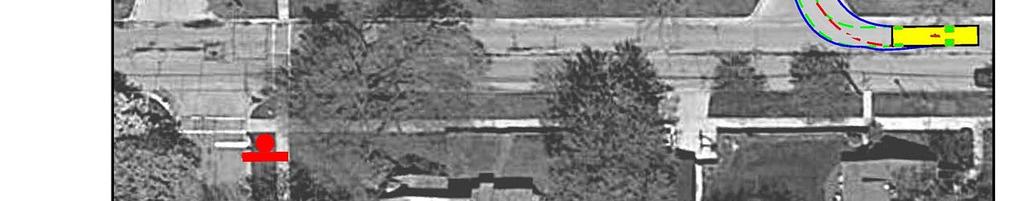
4 1. Introduction This report summarizes the findings and recommendations of a Traffic Circulation and Pedestrian Safety Study conducted by Kenig, Lindgren, O Hara, Aboona, Inc. (KLOA, Inc.) for the North Campus of Lyons Township High School (LTHS) in La Grange, Illinois. Figure 1 shows an aerial map of the LTHS North Campus and project study area. This study was jointly sponsored by the Village of La Grange and Lyons Township High School District 204. The purpose of the study is two-fold: 1. To develop an organized traffic circulation plan for student drop-off/pick-up. 2. To identify measures to reduce vehicular-pedestrian conflicts and increase safety for the high volume of pedestrians that cross Cossitt Avenue between the main school building on the south side of the street and the Vaughan Building and staff-visitor parking lot on the north side of the street. The following chapters of this report include (1) an assessment of existing conditions, and (2) a description of potential pedestrian safety measures and school traffic circulation options. LTHS North Campus 1
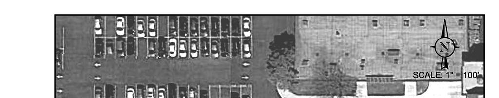
5 Parking Lot Vaughan Building N Main Building Figure 1 Aerial View of LTHS North Campus Study Area LTHS North Campus 2
6 2. Existing Conditions KLOA, Inc. conducted field reconnaissance of the LTHS North Campus study area and observed traffic and pedestrian conditions to document the current street design, traffic controls, school bus loading, drop-off/pick-up volumes, pedestrian volumes, parking conditions, and pedestrian safety measures. The reconnaissance was conducted during the school start and dismissal times prior to the end of the 2015 Spring Semester. The data collected provided a basis for developing the circulation options and pedestrian safety measures discussed in Chapter 3. Seven components of existing conditions are summarized below. 1. Characteristics of the key streets surrounding the LTHS North Campus 2. North Campus school hours, population and travel mode 3. School bus circulation and loading 4. Student drop-off and pick-up 5. Pedestrian street crossings 6. School parking 7. Significant issues and concerns Street System Characteristics The LTHS North Campus is located just south of the BNSF rail line along the west side of Brainard Avenue. The area surrounding the campus is predominantly residential to the east, south and west. The characteristics of the key streets providing access to the North Campus are described below. Brainard Avenue is a north-south, two-lane roadway in the study area with one lane in each direction and a striped parking lane along the east side of the street. Through the study area Brainard Avenue is under the jurisdiction of the Village of La Grange and is classified by the Village as a collector street. Brainard Avenue carries approximately 6,200 vehicles per day (vpd) and is approximately 30 feet wide with sidewalks along both sides of the street. There is an unprotected crosswalk on Brainard Avenue at Elm Avenue that is supported with pedestrian crossing signs and advance pedestrian crossing signs. The posted speed limit on Brainard Avenue is 30 miles per hour (mph), except along the North Campus frontage where there is a 20 mph school speed zone on school days. Parking is prohibited along both sides of Brainard LTHS North Campus 3
7 Avenue from the BNSF rail line south to Elm Avenue, but two-hour parking is permitted along the east side of the street between 10:00 A.M. and 5:00 P.M., Monday through Friday, to the north of the rail line and south of Elm Avenue. Cossitt Avenue is an east-west, two-lane roadway in the study area with one lane in each direction. Through the study area Cossitt Avenue is under the jurisdiction of the Village of La Grange and is classified by the Village as a collector street. Cossitt Avenue carries approximately 2,750 vpd and is approximately 30 feet wide with sidewalks along both sides of the street. The intersection of Cossitt Avenue with Brainard Avenue is under multiway stop control and there are crosswalks on both approaches of Brainard Avenue and the west approach of Cossitt Avenue. There are unprotected crosswalks on Cossitt Avenue at Park Avenue and mid-block between Brainard Avenue and Park Avenue, neither of which is supported with the most current pedestrian crossing signs. There is a 20 mph school speed zone on Cossitt Avenue along the North Campus frontage and parking is prohibited along both sides of Cossitt in the vicinity of the North Campus. Park Avenue is a north-south, two-lane local street that is under the jurisdiction of the Village of La Grange. Park Avenue is approximately 30 feet wide with sidewalks along both sides of the street. The intersection of Park Avenue with Cossitt Avenue is under stop control on Park and there are crosswalks on all three approaches of the intersection. The posted speed limit on Park Avenue is 25 mph. Parking is prohibited along the east side of the street and restricted along the west side of the street between 8:00 A.M. and 4:00 P.M., Monday through Friday. Elm Avenue is an east-west, two-lane local street that is under the jurisdiction of the Village of La Grange. Elm Avenue is approximately 30 feet wide with sidewalks along both sides of the street. The intersections of Elm Avenue with Brainard Avenue and Park Avenue are under stop control on Elm and there are crosswalks on Elm at both of these intersections. The posted speed limit on Elm Avenue is 25 mph. Parking is prohibited along both sides of the street between Brainard Avenue and Park Avenue, and along the south side of the street between Park Avenue and Blackstone Avenue. Parking is restricted between 8:00 A.M. and 4:00 P.M. on school days on both sides of Elm Avenue to the west of Blackstone Avenue and on the north side of Elm Avenue between Park Avenue and Blackstone Avenue. The existing traffic controls and parking regulations on the study area roadways are shown in Figure 2. North Campus School Hours, Population and Travel Mode The following points describe the school hours, population and travel modes at North Campus: On a regular school day, classes at North Campus start at 7:45 A.M. and dismiss at 2:59 P.M. On late start days, classes start at 8:45 A.M. and dismiss at 3:04 P.M. The North Campus serves approximately 2,016 students in the 11 th and 12 th Grades. LTHS North Campus 4
8
9 Approximately 27% of the student population resides in La Grange, with the remaining students residing in Western Springs (19%), La Grange Park (17%), Brookfield (13%), Countryside (9%), La Grange Highlands (3%), Burr Ridge (3%), Indian Head Park (3%), Willow Springs (3%), Hodgkins (2%), and McCook (1%). Approximately 62% of the student population (1,250 students) is eligible to ride the bus; the remaining 38% of students are dropped-off/picked up, walk, bike, or drive and park either around the West Field athletic area (Area H decal parking area) or in the Village s commuter parking lots (i.e., Lot 13, Hillgrove Avenue) if permits are purchased. There are 275 faculty/staff members at North Campus. Approximately 95% of faculty/staff drive to North Campus and are issued permits to park in the school s parking lot. The remaining 5% of faculty/staff take Metra or walk to campus. School Bus Circulation and Loading There are approximately 27 school buses that serve the North Campus. The buses arrive between 7:15 and 7:45 A.M. during the regular schedule morning arrival period. During the regular schedule afternoon dismissal period, buses arrive and depart in two bus shifts, with the first shift arriving prior to the dismissal period and leaving by 3:20 P.M. and the second shift arriving after 3:15 P.M. and leaving by 3:30 P.M. The buses approach the campus from Brainard Avenue and turn west onto Elm Avenue. The buses use the Elm Avenue curbfront adjacent to the main building for loading and unloading, or turn north on Park Avenue and use the Park Avenue curbfront adjacent to the main building for loading and unloading. In the morning, buses were observed to approach, unload students, and depart the campus within a quick two-to-three minute period, and all but one of the buses used the Elm Avenue curbfront to unload. When departing the campus, 80 percent of the buses were observed to continue west on Elm Avenue with the remaining 20 percent turning south on Park Avenue. In the afternoon, buses stage on-site for a longer period, which requires use of both the Elm Avenue and Park Avenue curbfronts and necessitates a staggered bus arrival/departure schedule. Buses that arrived in the first shift were staged at the curb for approximately minutes. Buses that arrived in the second shift were only on-site for two to three minutes. Approximately percent of the buses used Elm Avenue to load students, with the remaining buses using Park Avenue. Of the buses that loaded on Elm Avenue, 75 percent were observed to depart the campus by continuing west on Elm Avenue, with the remaining buses turning south on Park Avenue. Of the buses that loaded on Park Avenue, 50 percent turned east on Cossitt Avenue and the other 50 percent turned west on Cossitt. LTHS North Campus 6
10 Student Drop-off and Pick-Up There is no specified drop-off and pick-up procedure at the North Campus. Further, due to temporary street closures on school days and posted parking regulations by District 204 and the Village of La Grange, there are no legal drop-off and pick-up locations adjacent to the school. The school utilizes minicades with Do Not Enter signs or Stop signs to restrict access to Elm Avenue (between Brainard Avenue and Park Avenue) and Park Avenue (between Cossitt Avenue and Elm Avenue) during bus arrival and departure times, which limits drop-off/pick-up activity on the west and south sides of the school. School policies and Village parking regulations prohibit parking, stopping, standing, and drop-off/pick-up on Cossitt Avenue (between Brainard Avenue and Park Avenue), which limits drop-off/pick-up activity on the north side of the school. Village parking regulations on Brainard Avenue prohibit drop-off/pick-up on the east side of the school, and parking regulations on Cossitt Avenue (west of Park Avenue), Elm Avenue, Blackstone Avenue, and Park Avenue restrict drop-off/pick-up activity further west and south of the school. As a result of these temporary street closures and parking regulations, dropping off and picking up students close to the school can be challenging and results in these activities occurring in illegal locations, such as along Cossitt and in the striped lane on the east side of Brainard. Observations performed on Wednesday, May 20, 2015 indicated that 163 drop-offs occurred on the section of Cossitt Avenue between Brainard Avenue and Park Avenue during the morning arrival period, as shown in Figure 3, while 246 pick-ups occurred on this section of Cossitt during the afternoon pick-up period. In the no parking zone on Cossitt Avenue to the west of Park Avenue, there were 28 drop-offs observed in the morning and 29 pick-ups observed in the afternoon. There were 69 drop-offs observed in the morning and 34 pick-ups observed in the afternoon in the no parking zone on Brainard Avenue. Pedestrian Street Crossings Since the two buildings on the North Campus are bisected by Cossitt Avenue, a substantial volume of students and staff cross Cossitt Avenue to travel between the two buildings and to reach the staff parking lot adjacent to the north (Vaughan) building, despite the pedestrian tunnel that exists between the two buildings. As noted previously, there are two unprotected crosswalks on Cossitt Avenue that are used by these pedestrians, one at Park Avenue and the other midblock between Brainard Avenue and Park Avenue. Observations performed on Wednesday, May 20, 2015 indicated that there were a total of 920 pedestrian crossings on Cossitt Avenue during the morning arrival period and 815 pedestrian crossings on Cossitt during the afternoon dismissal period, as shown in Figure 3. Further, since the east side of Brainard Avenue is used for drop-offs and pick-ups, a significant volume of students cross Brainard at the unprotected crosswalk at Elm Avenue. Observations from May 20, 2015 indicated that 142 pedestrians crossed this section of Brainard during the morning arrival period and 117 pedestrians crossed Brainard during the afternoon dismissal period. LTHS North Campus 7
11
12 School Parking There is one off-street parking lot at the North Campus, located immediately west of the Vaughan Building, that is currently reserved for staff and visitors. The lot contains 359 marked parking stalls. Students with cars must park off-campus and have the option of obtaining an Area H decal to park on Cossitt Avenue and Elm Avenue adjacent to the West Field athletic area, purchase a commuter parking decal from the Village to park in Lot 13 (immediately north of the Vaughan Building) or along Hillgrove Avenue, or find unregulated on-street parking more distant from the campus. Significant Issues and Concerns Based on our field observations of existing traffic and pedestrian patterns at the North Campus, there are several issues that should be addressed to reduce the potential for vehicular-pedestrian conflicts and to increase compliance with the posted parking regulations and school dropoff/pick-up policies. These issues are as follows: The lack of a dedicated student drop-off/pick-up zone(s) adjacent to the school results in drop-off/pick-up violations along Cossitt Avenue, parking violations along Brainard Avenue, and high volumes of pedestrians crossing Brainard Avenue at unprotected locations. The unprotected crosswalks on Cossitt Avenue and Brainard Avenue increase the potential for vehicular-pedestrian conflicts. The wide (30-foot) two-lane cross-section on Cossitt Avenue allows for illegal drop-off/pickup activity to occur along the curb lane without impeding through traffic. Drop-offs/pick-ups near the mid-block crosswalk on Cossitt Avenue can block access to the crosswalk or impair the sight lines between motorists and pedestrians. Drop-off/pick-up traffic and afternoon school buses circulate through the heavily-utilized unprotected crosswalks on Cossitt Avenue when departing the campus. The school does not utilize traffic aides to assist bus operations, control traffic at the unprotected pedestrian crossings, or enforce the parking and drop-off/pick-up policies on Cossitt Avenue. LTHS North Campus 9
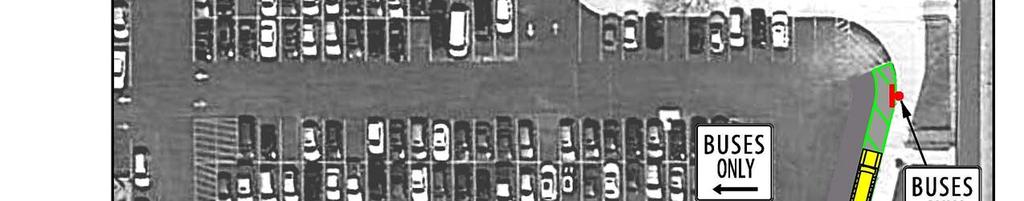
13 3. Circulation Options / Pedestrian Safety Measures Recommendations to address the significant issues and concerns observed at the North Campus have been developed in the form of three options. Each of the three options has a different area of focus, including pedestrian measures, drop-off/pick-up accommodations, and school bus circulation/staging. The intent is to achieve consensus on a preferred solution to better organize vehicular circulation on campus while reducing vehicular-pedestrian conflicts and increasing pedestrian safety. It is anticipated that the preferred solution may be a hybrid reflecting a combination of various elements from one or more of the options. The details of each option are highlighted below. Option 1 Pedestrian Safety Enhancements The intent of Option 1 is to minimize changes to the current bus staging and student dropoff/pick-up operation while implementing measures to maximize pedestrian safety. Option 1 is illustrated in Figure 4 and involves the following measures: Install a raised crosswalk at the mid-block pedestrian crossing on Cossitt Avenue with curb extensions that narrow the crossing width to 20 feet. Alternatively, extend the curbline by 5 feet along both sides of Cossitt Avenue for the full length of the block between Park Avenue and Brainard Avenue to narrow the pedestrian crossing width to 20 feet and reduce the potential for motorists to drop-off and pick-up along the curb (see Figure 5). Crosswalk would not be raised. Replace the existing school crossing signage at the mid-block crossing on Cossitt Avenue with the most current standards from the Manual on Uniform Traffic Control Devices (MUTCD), including school crossing signage with a diagonal downward pointing arrow. These signs should be posted back-to-back on each side of the crossing so that the signs on both sides of the street face both directions of travel on Cossitt Avenue. Install an In-Street Schoolchildren Crossing sign on the centerline of the raised crosswalk. Install an additional No Parking, No Standing, No Stopping Anytime sign on both sides of Cossitt Avenue between the mid-block crossing and Brainard Avenue. LTHS North Campus 10
14
15
16 Utilize school staff to enforce the No Parking, No Standing, No Stopping Anytime regulations along Cossitt Avenue between Park Avenue and Brainard Avenue. Install stop signs on both approaches of Cossitt Avenue at Park Avenue to create a multiway stop condition that provides protected pedestrian crossings at the intersection. Install No Right Turn signage on Park Avenue at Cossitt Avenue with supplementing signage indicating that the regulation is in effect on School Days from 7:00-9:00 A.M. and from 3:00-4:00 P.M. Remove the existing pedestrian crossing sign on eastbound Cossitt Avenue at Park Avenue. After 4:00 P.M., relocate the afternoon activity bus staging to the parking lot. Use the east curb adjacent to the Vaughan Building. Install an In-Street Pedestrian Crossing sign with School plaque on the centerline of the Brainard Avenue crosswalk at Elm Avenue. Option 1 would result in no parking loss within the school s parking lot and no changes in traffic operations or parking regulations on Brainard Avenue and Elm Avenue. Option 2 Designated Drop-off/Pick-up Zones The intent of Option 2 is to minimize changes to the current bus staging operation while creating designated student drop-off/pick-up zones along the school frontage or as proximate to the school frontage as possible. Option 2 is illustrated in Figure 6 and involves the following measures: Relocate the striped out lane on Brainard Avenue from the east side of the street to the west side of the street between Burlington Avenue and Elm Avenue. Utilize pavement markings on Brainard Avenue to the north of Burlington Avenue and to the south of Elm Avenue to transition the striped lane back to the east side of the street. Install signage along the striped lane on Brainard Avenue designating the lane as a school loading zone on school days from 7:00 A.M.-4:00 P.M. The loading zone would accommodate approximately 17 cars to the north of Cossitt Avenue and 25 cars to the south of Cossitt Avenue. Install similar pavement striping on the south side of Cossitt Avenue (between Park Avenue and Blackstone Avenue) and on the north side of Elm Avenue (between Park Avenue and Blackstone Avenue) and install similar signage designating these lanes as school loading zones on school days. The loading zone would accommodate approximately 11 cars on Cossitt Avenue and 11 cars on Elm Avenue. Remove No Parking signs from the west side of Brainard Avenue (Burlington Avenue-Elm Avenue), south side of Cossitt Avenue (Park Avenue-Blackstone Avenue), and north side of Elm Avenue (Park Avenue-Blackstone Avenue). LTHS North Campus 13
17
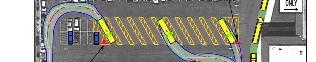
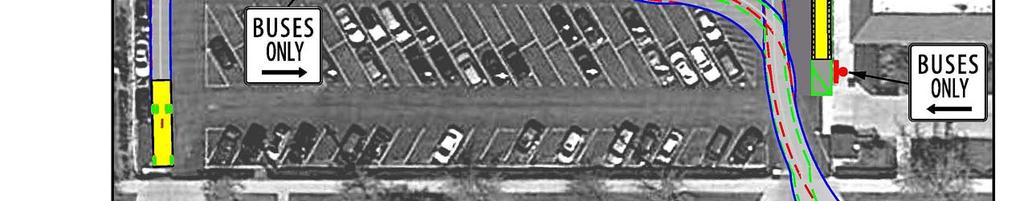
18 Within the parking lot, replace the 28 parking spaces along the curb adjacent to the Vaughan Building with diagonal pavement striping. Install signage designating the lane as a school loading zone on school days from 7:00 A.M.-4:00 P.M. The loading zone would accommodate approximately 13 cars. Use the Cossitt Avenue east drive for entry to the parking lot school loading zone and the Cossitt Avenue center drive (opposite Blackstone Avenue) for exit from the parking lot. Open the fence to the service drive on the north side of the Vaughan Building during school arrival and dismissal times to give drop-off/pick-up traffic in the parking lot the option of exiting directly onto Brainard Avenue (opposite Burlington Avenue). Utilize signage at the west end of the parking lot loading zone to guides drop-off/pick-up traffic to either the Cossitt Avenue exit or the Brainard Avenue exit. Within the parking lot, install signage along the striped lane on the Cossitt Avenue center drive designating the lane as a school loading zone on school days from 7:00 A.M.-4:00 P.M. The loading zone would accommodate approximately 8 cars. After 4:00 P.M., relocate the afternoon activity bus staging to the parking lot. Use the east curb adjacent to the Vaughan Building. The proposed school loading zones in Option 2 would provide curb space for a total of approximately 85 vehicles to drop-off or pick-up students at any given time. It should be noted that District 204 implemented a similar school loading zone within the parking lot during Summer 2015 while Cossitt Avenue was being resurfaced. Option 2 would result in the loss of 28 spaces in the parking lot. Based on a faculty/staff size of 275 people of which 95 percent drive to campus, there is a need for 261 staff parking spaces. The lot also provides nine visitor parking spaces and eight reserved spaces for school vans and grounds keeping vehicles. Assuming that the visitor parking supply is sufficient and school policies will continue to restrict students from parking in the lot, the North Campus would have a minimum parking need for 278 spaces. The loss of 28 parking spaces in the lot would reduce the parking capacity of the lot to 331 spaces, which would still be more than adequate to meet the needs of the school. Option 3 Relocation of Bus Staging The intent of Option 3 is to relocate the bus staging operation to create a designated student drop-off/pick-up zone along the school frontage without modifying the pavement striping pattern on Brainard Avenue. Option 3 is illustrated in Figure 7 and involves the following measures: Relocate the bus loading and unloading operations to the school s parking lot. Replace 41 of the spaces within the parking lot s southernmost perpendicular parking bay with 11 bus loading spaces. Install signage designating the spaces for Buses Only. LTHS North Campus 15
19
20 Within the parking lot, replace the 16 parking spaces along the east curb adjacent to the Vaughan Building with diagonal pavement striping. Install signage designating the lane for Buses Only. The lane would provide space for 3-4 buses at a time and would be the preferred location for bus unloading in the morning. Buses would use the Cossitt Avenue east drive for entry to the parking lot and the Cossitt Avenue center drive (opposite Blackstone Avenue) for exit from the lot. Figure 8 shows an example of the school bus maneuvers into and out of the angled loading spaces. Alternatively, extend the 8-foot wide sidewalk on the south side of the Applied Technology/Industrial Arts wing of the Vaughan building 170 feet to the west to create a longer protected loading zone for school buses. This extended space could accommodate up to 11 buses. In addition, replace the landscaping on the west side of the parking lot s center drive (opposite Blackstone Avenue) with an 8-foot wide sidewalk, and use this space for additional bus loading in the afternoon. The space could support up to 4 buses. This alternative is illustrated in Figure 9. This alternate would allow the parking lot to be restriped for improved circulation and efficiency. Utilize portable traffic barricades to close Cossitt Avenue between Park Avenue and Brainard Avenue for a 30-minute period during the school arrival and dismissal times (7:15-7:45 A.M.; 3:00-3:30 P.M.) to eliminate vehicular conflicts with the large volume of pedestrians crossing Cossitt Avenue to travel to and from the bus staging area in the parking lot. Install diagonal pavement striping on the north side of Elm Avenue (between Park Avenue and Brainard Avenue) and on the east side of Park Avenue (between Cossitt Avenue and Elm Avenue). Install signage designating these lanes as school loading zones on school days. The loading zone would accommodate approximately 14 cars on Elm Avenue and 29 cars on Park Avenue. Remove No Parking Bus Stop signs from the north side of Elm Avenue (Park Avenue- Brainard Avenue) and replace them with the school loading zone signage. Remove the No Parking Any Time signs from the east side of Park Avenue (Cossitt Avenue-Elm Avenue) and replace them with the school loading zone signage. Discontinue use of the portable Do Not Enter/Stop signs on Elm Avenue and Park Avenue to allow drop-off/pick-up circulation on these blocks. Utilize the striped lane on the east side of Brainard Avenue (Cossitt Avenue-Elm Avenue) as a school loading zone by removing the No Parking Any Time signs and replacing them with school loading zone signage. The loading zone would accommodate approximately 17 cars. Install stop signs on both approaches of Park Avenue at Elm Avenue to create a multiway stop condition at a location that has a significant number of pedestrian crossings and will experience heavier drop-off/pick-up traffic activity. LTHS North Campus 17
21
22
23 The proposed school loading zones in Option 3 would provide curb space for a total of approximately 60 vehicles to drop-off or pick-up students at any given time. It should be noted that the east side of Brainard Avenue is already being used as a drop-off/pick-up zone despite the posted No Parking Any Time regulations. Option 3 would result in the loss of 56 spaces in the parking lot, which would reduce the parking capacity of the lot to 303 spaces, which would still be adequate to meet the minimum parking needs (278 spaces) of the school. The alternate bus staging configuration in Option 3 would result in the loss of 42 spaces in the parking lot, or the loss of 35 spaces if the space on the north side of the sidewalk extension was used for parallel parking instead of green space. LTHS North Campus 20
24 4. Conclusions and Next Steps This Traffic Circulation and Pedestrian Safety Study for the North Campus of Lyons Township High School includes three potential options to reconfigure the drop-off/pick-up circulation, relocate the bus staging operation, and/or reduce vehicular-pedestrian conflicts while increasing pedestrian safety on Cossitt Avenue, Brainard Avenue, Elm Avenue, and Park Avenue. The parking impacts that would result from the three options range from no loss of parking in the school s 359-space parking lot to the loss of up to 56 parking spaces in the lot. In all cases, however, it appears that an adequate quantity of parking would remain in the lot to meet the minimum parking needs of the school (278 spaces). Traffic impacts from the various options would include the potential closure of Cossitt Avenue between Park Avenue and Brainard Avenue for a 30-minute period around the school start and dismissal times, increased delay from multiway stop control at the Park Avenue intersections with Cossitt Avenue and Elm Avenue, right-turn restrictions on Park Avenue at Cossitt Avenue, and/or the potential shifting in traffic patterns on Brainard Avenue. The intent of the development of three circulation options is to generate discussion on potential solutions and to achieve consensus on a preferred solution to better organize vehicular circulation on campus while reducing vehicular-pedestrian conflicts and increasing pedestrian safety. It is anticipated that the preferred solution may be a hybrid reflecting a combination of various elements from one or more of the options. The next step is to discuss the circulation options and reach consensus on the elements of a preferred solution. If desired, KLOA, Inc. will develop a final circulation plan that reflects the preferences of District 204. LTHS North Campus 21
Windy Ridge Elementary School
 Windy Ridge Elementary School SCHOOL ROUTE PLAN For WINDY RIDGE ELEMENTARY SCHOOL LOCATION 54 ORANGE COUNTY Prepared for: ORANGE COUNTY SCHOOL ASSESSMENT PROGRAM ORANGE COUNTY PUBLIC WORKS Traffic Engineering
Traffic Study North Shore School District 112
 Traffic Study North Shore School District 112 Proposed Expansion of Northwood Junior High School Prepared By: May 1, 2015 1. Introduction Kenig, Lindgren, O Hara, Aboona, Inc. (KLOA, Inc.) has been retained
Chapter 2: Standards for Access, Non-Motorized, and Transit
 Standards for Access, Non-Motorized, and Transit Chapter 2: Standards for Access, Non-Motorized, and Transit The Washtenaw County Access Management Plan was developed based on the analysis of existing
Appendix C. TRAFFIC CALMING PROGRAM TOOLBOX
 Appendix C. TRAFFIC CALMING PROGRAM TOOLBOX PHASE I...2 Do Not Enter Sign...3 One-Way Sign...4 Turn Prohibition...5 Pavement Markings...6 Speed Monitoring Trailer...7 Neighborhood Speed Watch...8 Police
Drag and drop pic and stretch/crop to the limits of the blue rectangle (delete this text box) Maxey Elementary School
 Maxey Elementary School") Drag and drop pic and stretch/crop to the limits of the blue rectangle (delete this text box) Maxey Elementary School SCHOOL ROUTE PLAN For MAXEY ELEMENTARY SCHOOL LOCATION 33 ORANGE COUNTY Prepared for:
Drag and drop pic and stretch/crop to the limits of the blue rectangle (delete this text box) Maxey Elementary School SCHOOL ROUTE PLAN For MAXEY ELEMENTARY SCHOOL LOCATION 33 ORANGE COUNTY Prepared for:
Meadow Woods Elementary School
 Drag and drop pic and stretch/crop to the limits of the blue rectangle (delete this text box) Meadow Woods Elementary School Drag and drop pic and stretch/crop to the limits of the blue rectangle (delete
Town of Mooresville, North Carolina Neighborhood Traffic Calming and Control Device Policy
 Town of Mooresville, North Carolina Neighborhood Traffic Calming and Control Device Policy Adopted January 6, 2014 Town of Mooresville Development Services Department TOWN OF MOORESVILLE NEIGHBORHOOD TRAFFIC
Table 1 Traffic and Pedestrian Counts on Lafayette Street
 Downtown Salem Transportation Study 2 July 8, 2005 On-street parking is allowed on both sides of Lafayette Street. Cars were parked at the island that separates a pull-out area in front of the school entrance
Sebastopol Charter School Traffic Management Plan
 Sebastopol Charter School The serves as the working document in support of these essential goals: to ensure the safety and efficiency of student arrival to and departure from school to ensure the safety
Orange Center Elementary School
 Drag and drop pic and stretch/crop to the limits of the blue rectangle (delete this text box) Orange Center Elementary School Drag and drop pic and stretch/crop to the limits of the blue rectangle (delete
City of Albert Lea Policy and Procedure Manual 4.10 ALBERT LEA CROSSWALK POLICY
 4.10 ALBERT LEA CROSSWALK POLICY PURPOSE: Pedestrian crosswalks are an integral part of our transportation infrastructure. To be effective and promote safety, marked crosswalks must be installed after
Neighborhood Traffic Study Area Number 4 Downers Grove, Illinois
 Neighborhood Traffic Study Area Number Downers Grove, Illinois Prepared for: Submitted by: Kenig, Lindgren, O Hara, Aboona, Inc. May 05 Neighborhood Traffic Study Area Number Downers Grove, Illinois Prepared
Hidden Oaks Elementary School
 Hidden Oaks Elementary School SCHOOL ROUTE PLAN For HIDDEN OAKS ELEMENTARY SCHOOL LOCATION 13 ORANGE COUNTY Prepared for: ORANGE COUNTY SCHOOL ASSESSMENT PROGRAM ORANGE COUNTY PUBLIC WORKS Traffic Engineering
10.0 CURB EXTENSIONS GUIDELINE
 10.0 CURB EXTENSIONS GUIDELINE Road Engineering Design Guidelines Version 1.0 March 2017 City of Toronto, Transportation Services City of Toronto Page 0 Background In early 2014, Transportation Services
MUTCD Part 6G: Type of Temporary Traffic Control Zone Activities
 MUTCD Part 6G: Type of Temporary Traffic Control Zone Activities 6G.01 Typical Applications Each temporary traffic control (TTC) zone is different. Many variables, such as location of work, highway type,
Highland Park High School Campus Traffic and Parking Study
 Highland Park High School Campus Traffic and Parking Study February 24, 2015 Eriksson Engineering Associates, Ltd. Prepared for: Township High School District 113 Eriksson Engineering Associates, Ltd.
Neighborhood Traffic Study Area Number 5
 Neighborhood Traffic Study Area Number 5 Downers Grove, Illinois Prepared for: Submitted by: Kenig, Lindgren, O Hara, Aboona, Inc. April 2017 Neighborhood Traffic Study Area Number 5 Downers Grove, Illinois
HALFF TRAFFIC MANAGEMENT PLAN. Richardson ISD Northwood Hills Elementary School Dallas, Texas. /? /4O/2o16
 30279 161966 TRAFFIC MANAGEMENT PLAN Richardson ISD Northwood Hills Elementary School August 30 2016 Exhibit 976B Planned Development District No. 976 Z156-311(OTH) Approved City Plan Commission October
Lake Whitney Elementary School
 Lake Whitney Elementary School SCHOOL ROUTE PLAN For LAKE WHITNEY ELEMENTARY SCHOOL LOCATION 18 ORANGE COUNTY Prepared for: ORANGE COUNTY SCHOOL ASSESSMENT PROGRAM ORANGE COUNTY PUBLIC WORKS Traffic Engineering
CONTENTS EXECUTIVE SUMMARY 1
 CONTENTS CHAPTER PAGE EXECUTIVE SUMMARY 1 1 ISSUES AND PURPOSE OF THE ANALYSIS 2 1.1 Background 2 1.2 Analysis Area 2 1.3 Issues and Observations 3 1.4 Project and Public Meetings 3 2 LIST OF PREFERRED
Appendix A: Crosswalk Policy
 Appendix A: Crosswalk Policy Appendix A: Crosswalk Policy Introduction This citywide Crosswalk Policy is aimed at improving pedestrian safety and enhancing pedestrian mobility by providing a framework
Implementing the Three Es of School Zone Traffic Calming
 Implementing the Three Es of School Zone Traffic Calming Use this evaluation tool as a guide to analyze the specific safety needs of your school. SCHOOL PROFILE School Name: School District: Address: Phone
ATTACHMENT NO. 11. RRLRT No. 2. Railroad / Light Rail Transit Technical Committee TECHNICAL COMMITTEE: Busway Grade Crossings STATUS/DATE OF ACTION
 ATTACHMENT NO. 11 RRLRT No. 2 TECHNICAL COMMITTEE: TOPIC: Railroad / Light Rail Transit Technical Committee Busway Grade Crossings STATUS/DATE OF ACTION RRLRT TC Draft: 06/23/2011 RRLRT TC Approval: 06/27/2014
5. RUNNINGWAY GUIDELINES
 5. RUNNINGWAY GUIDELINES These guidelines should be considered collectively when making runningway decisions. A runningway is the linear component of the transit system that forms the right-of-way reserved
Accommodating Pedestrians in the Work Zone
 Accommodating Pedestrians in the Work Zone Guidance for Section C Plan Preparers Some impacts cannot be avoided and those impacts apply to residents, businesses, motorists, and pedestrians alike. However,
U.S. Equities Realty. Luay R. Aboona, PE Principal. Traffic and Parking Evaluation Fourth Presbyterian Church of Chicago Chicago, Illinois
 9575 West Higgins Road, Suite 100 Rosemont, Illinois 60018 p: 847-518-9990 f: 847-518-9987 MEMORANDUM TO: FROM: Suzanne Kahle U.S. Equities Realty Kelly K. Conolly, PE Consultant Luay R. Aboona, PE Principal
Chapter 3.9 Timbercrest Elementary School. Volusia County MPO. November 2008
 Chapter 3.9 Timbercrest Elementary School Deltona, FL Volusia County MPO November 2008 Volusia County MPO School Bicycle and Pedestrian Review Study, Phase 3B School Summary Timbercrest Elementary School
Memorandum. Sunday, July 13, Saturday, July 19, 2014
 Memorandum To: David Lowin, Brooklyn Bridge Park Corporation From: Daniel Schack, AICP, PTP Date: Re: Brooklyn Bridge Park Pier 5/6 Loop Road Traffic Study Project No: 14-01-2407 At the request of Brooklyn
CURBSIDE ACTIVITY DESIGN
 5 CURBSIDE ACTIVITY DESIGN This chapter provides design guidance for separated bike lanes adjacent to curbside activities including parking, loading and bus stops. Typical configurations are presented
Transportation Impact Study for Abington Terrace
 Transportation Impact Study for Abington Terrace Abington Township, Montgomery County, PA Sandy A. Koza, P.E., PTOE PA PE License Number PE059911 Prepared by McMahon Associates, Inc. 425 Commerce Drive,
CONTENTS EXECUTIVE SUMMARY. 1 SUMMARY OF EXISTING CONDITIONS Issues and Observations Public Meeting (December 2005) 1
 1") CONTENTS CHAPTER PAGE EXECUTIVE SUMMARY ES-1 1 SUMMARY OF EXISTING CONDITIONS 1 1.1 Issues and Observations 1 1.2 Public Meeting (December 2005) 1 2 LIST OF POTENTIAL IMPROVEMENT STRATEGIES 2 2.1 Traffic
CONTENTS CHAPTER PAGE EXECUTIVE SUMMARY ES-1 1 SUMMARY OF EXISTING CONDITIONS 1 1.1 Issues and Observations 1 1.2 Public Meeting (December 2005) 1 2 LIST OF POTENTIAL IMPROVEMENT STRATEGIES 2 2.1 Traffic
ADA on Construction. Guidance for Section C Plan Preparers
 ADA on Construction Guidance for Section C Plan Preparers Some impacts cannot be avoided and those impacts apply to residents, businesses, motorists, and pedestrians alike. However, good planning can minimize
MEMORANDUM. Date: 9/13/2016. Citywide Crosswalk Policy
 MEMORANDUM Date: 9/13/2016 Re: Citywide Crosswalk Policy Foreword Through the s Circulation Element and Complete Streets Policy, it is the City s goal to promote walking trips and provide safe facilities
TRAFFIC IMPACT ANALYSIS
 TRAFFIC IMPACT ANALYSIS FOR THE CHAMPAIGN UNIT#4 SCHOOL DISTRICT PROPOSED HIGH SCHOOL (SPALDING PARK SITE) IN THE CITY OF CHAMPAIGN Final Report Champaign Urbana Urbanized Area Transportation Study 6/24/2014
122 Avenue: 107 Street to Fort Road
 : 107 Street to Fort Road November 24, 2015 4:30 8:00 p.m. Meeting Purpose Summarize project work completed to date Share results of public input from Phase 1 Share the draft concept plan and proposed
Michael A. Werthmann, PE, PTOE Principal
 9575 West Higgins Road, Suite 400 Rosemont, Illinois 60018 p: 847-518-9990 f: 847-518-9987 MEMORANDUM TO: FROM: Brian Lorenc GHB-630, LLC Michael A. Werthmann, E, TOE rincipal Luay R. Aboona, E rincipal
CHAPTER 6H. TYPICAL APPLICATIONS
 2006 Edition Page 6H-1 CHAPTER 6H. TYPICAL APPLICATIONS Section 6H.01 Typical Applications Support: Whenever the acronym TTC is used in this Chapter, it refers to temporary traffic control. Standard: The
Joe Routt Boulevard. Access Design Options
 Access Design Options Impacted area highlighted in yellow. Access Design Option 1 This option would involve closing Joe Routt between Gene Stallings Blvd. and Houston St. to car and bus traffic, creating
AGENDA ITEM 6 D THOMASVILLE ROAD (HERMITAGE BOULEVARD TO LIVE OAK PLANTATION ROAD) ROADWAY SAFETY AUDIT
 ROADWAY SAFETY AUDIT") May 15, 2018 AGENDA ITEM 6 D THOMASVILLE ROAD (HERMITAGE BOULEVARD TO LIVE OAK PLANTATION ROAD) ROADWAY SAFETY AUDIT TYPE OF ITEM: Discussion STATEMENT OF ISSUE The Florida Department of Transportation
May 15, 2018 AGENDA ITEM 6 D THOMASVILLE ROAD (HERMITAGE BOULEVARD TO LIVE OAK PLANTATION ROAD) ROADWAY SAFETY AUDIT TYPE OF ITEM: Discussion STATEMENT OF ISSUE The Florida Department of Transportation
Southside Pilot Proposal
 To improve bicycle access and mobility to UC Berkeley, Downtown Berkeley, and the Southside area, a pilot project could include a two-way parking-protected cycle track. Turn pockets and island bus stops
TRANSPORTATION STANDARDS
 INTRODUCTION LOCAL STREETS ON-STREET PARKING SIDEWALKS STREET LIGHTING STREET FURNISHINGS TRAFFIC CALMING STREET TREES MEDIAN PLANTING BOULEVARD LOCATIONS VILLAGE CENTER STREET LOCATIONS RESIDENTIAL STREET
SCHOOL ROUTE PLAN. For HUNTER S CREEK ELEMENTARY SCHOOL LOCATION 14 ORANGE COUNTY. Prepared for:
 SCHOOL ROUTE PLAN For HUNTER S CREEK ELEMENTARY SCHOOL LOCATION 14 ORANGE COUNTY Prepared for: ORANGE COUNTY SCHOOL ASSESSMENT PROGRAM ORANGE COUNTY PUBLIC WORKS Traffic Engineering Division 42 South John
Addendum to SDDCTEA Pamphlet 55 17: Better Military Traffic Engineering Revision 1 Effective: 24 Aug Crosswalk Guidelines
 Addendum to SDDCTEA Pamphlet 55 17: Better Military Traffic Engineering Revision 1 Effective: 24 Aug 2017 Crosswalk Guidelines Warrants for Uncontrolled Crosswalk Locations Crosswalks at Midblock Locations
July 5, Arthur R. Ware, Jr. Elementary School 2017 Safe Routes to School Walkabout Report
 July 5, 2017 Arthur R. Ware, Jr. Elementary School 2017 Safe Routes to School Walkabout Report 1 Walkabout Report Introduction On April 28, 2017, City, School, and SAWMPO staff met to conduct a Safe Routes
PUBLIC MEETING November 29, 2016 Malibu City Hall. PCH Parking Study
 PUBLIC MEETING November 29, 2016 Malibu City Hall PCH Parking Study Tonight s Agenda Presentation (6:30-7pm) Study goals Existing parking conditions Collision analysis Parking improvement concepts Break-out
Contents. Champaign-Urbana Mass Transit District Stop Placement Guidelines
 Contents Champaign-Urbana Mass Transit District Introduction... 1 Stop Spacing... 2 Rural... 2 Low Density Suburban... 2 General Urban... 2 Urban Core... 2 Operational Safety... 3 Stop Placement... 4 Nearside
Chapter 3.3 Horizon Elementary School. Volusia County MPO. June 2009
 Chapter 3.3 Horizon Elementary School Port Orange, FL Volusia County MPO June 2009 Volusia County MPO School Bicycle and Pedestrian Review Study, Phase 3C School Summary Horizon Elementary School is located
Southside Road. Prepared for: City of St. John s Police & Traffic Committee. Prepared by: City of St. John s Traffic Division
 Southside Road Prepared for: City of St. John s Police & Traffic Committee Prepared by: City of St. John s Traffic Division January 2007 Southside Road - Traffic Report Page 1 of 9 BACKGROUND: th At the
Caltrans Sloat Boulevard Pedestrian Safety Project Response to Community Questions, Comments & Concerns
 Caltrans Sloat Boulevard Pedestrian Safety Project Response to Community Questions, Comments & Concerns Revised: May 10, 2016 The California Department of Transportation (Caltrans) is planning various
TOWN OF CHAPEL HILL POLICY AND PROCEDURES FOR TRAFFIC CALMING MEASURES
 TOWN OF CHAPEL HILL POLICY AND PROCEDURES FOR TRAFFIC CALMING MEASURES (Adopted by the Town Council on June 30, 2004) (Revised December 6, 2010) (Revised February 8, 2016) POLICY AND PROCEDURES FOR TRAFFIC
Exhibit 964B Traffic Management Pianj. (no change) Daily Start/End Schedule Grades K-5th: Grades K-5th: >Start: 7:55 AM
 Daily Start/End Schedule Grades K-5th: Grades K-5th: >Start: 7:55 AM") Exhibit 964B 30115 1 6 10 15 Traffic Management Pianj Traffic Management Plan A Traffic Management Plan (TMP) is important to safely achieve an optimum level of traffic flow and circulation during peak
Exhibit 964B 30115 1 6 10 15 Traffic Management Pianj Traffic Management Plan A Traffic Management Plan (TMP) is important to safely achieve an optimum level of traffic flow and circulation during peak
Final Sidewalk Feasibility Study
 Garfield Drive From Anastasia Drive to Elizabeth Place City of South Daytona July 23, 2009 Final Sidewalk Feasibility Study Prepared for: Prepared by: Final Sidewalk Feasibility Study Garfield Drive 2
EUCLID AVENUE PARKING STUDY CITY OF SYRACUSE, ONONDAGA COUNTY, NEW YORK
 EUCLID AVENUE PARKING STUDY CITY OF SYRACUSE, ONONDAGA COUNTY, NEW YORK CITY OF SYRACUSE DEPARTMENT OF PUBLIC WORKS 1200 CANAL STREET EXTENSION SYRACUSE, NEW YORK 13210 DRAFT REPORT DATE: November 13,
Appendix T CCMP TRAIL TRAFFIC & TRANSPORTATION DESIGN STANDARD
 Appendix T CCMP 3.3.4 TRAIL TRAFFIC & TRANSPORTATION DESIGN STANDARD 3.3.4 Trail Traffic and Transportation Design Multi-use trails have certain design standards, which vary depending on the agency that
C C C
 C-012-001 Thank you for your support for the creation of new public space and nonmotorized access between downtown and the waterfront through the Overlook Walk, the East-West Connections, and the Promenade.
Arlington Public Schools Thomas Jefferson Site Evaluation Transportation Networks. Thomas Jefferson Working Group Meeting #6 November 10, 2014
 Arlington Public Schools Thomas Jefferson Site Evaluation Transportation Networks Thomas Jefferson Working Group Meeting #6 November 10, 2014 2 3 INTRODUCTION 4 Goal of our work: Identify and assess multi-modal
City of Vestavia Hills Traffic Calming Policy for Residential Streets
 City of Vestavia Hills Traffic Calming Policy for Residential Streets PURPOSE: The purpose of the Traffic Calming Policy for Residential Streets is to address safety concerns related to vehicular traffic
CHAPTER 6H. TYPICAL APPLICATIONS
 Section 6H.01 Typical Applications Support: CHAPTER 6H. TYPICAL APPLICATIONS Chapter 6G contains discussions of typical temporary traffic control activities. Chapter 6H presents typical applications for
Dr. M.L. King, Jr. Street North Complete Streets Resurfacing Opportunities HOUSING, LAND USE, AND TRANSPORTATION COMMITTEE MARCH 22, 2018
 Dr. M.L. King, Jr. Street North Complete Streets Resurfacing Opportunities HOUSING, LAND USE, AND TRANSPORTATION COMMITTEE MARCH 22, 2018 What s Happening The City plans to mill and resurface Dr. M.L.
DISTRIBUTION: Electronic Recipients List TRANSMITTAL LETTER NO. (17-01) MINNESOTA DEPARTMENT OF TRANSPORTATION. MANUAL: Road Design English Manual
 MINNESOTA DEPARTMENT OF TRANSPORTATION. MANUAL: Road Design English Manual") DISTRIBUTION: Electronic Recipients List MINNESOTA DEPARTMENT OF TRANSPORTATION DEVELOPED BY: Design Standards Unit ISSUED BY: Office of Project Management and Technical Support TRANSMITTAL LETTER NO.
DISTRIBUTION: Electronic Recipients List MINNESOTA DEPARTMENT OF TRANSPORTATION DEVELOPED BY: Design Standards Unit ISSUED BY: Office of Project Management and Technical Support TRANSMITTAL LETTER NO.
Fundamentals of Traffic Control Devices
 Fundamentals of Traffic Control Devices Traffic Engineering & Operations October 8, 2014 Raj Ponnaluri, Angela Wilhelm, and Christopher Lewis Agenda Agenda Signs Pavement Markings Signals Traffic Operations
Chapter 4.3 Enterprise Elementary. Volusia County MPO. March Page 7.0
 Chapter 4.3 Enterprise Elementary Enterprise, FL Volusia County MPO March 2008 Page 7.0 Volusia County MPO Bicycle and Pedestrian School Safety Review Study Introduction Enterprise Elementary School is
Ottawa Beach Road Study
 Ottawa Beach Road Study Prepared For: Park Township September 30, 2014 Project No. G140303 OTTAWA BEACH ROAD STUDY PREPARED FOR: PARK TOWNSHIP SEPTEMBER 30, 2014 PROJECT NO. G140303 TABLE OF CONTENTS 1.0
Chapter 4 TOOLBOX AND SAMPLE BIKE BOULEVARD LAYOUT
 Chapter 4 TOOLBOX AND SAMPLE BIKE BOULEVARD LAYOUT OVERVIEW This chapter describes a cohesive set of strategies to create a bicycle boulevard, namely to make streets safer and more efficient for bicycle
STREET and UTILITY REPAIRS WORK AREA PROTECTION GUIDE
 STREET and UTILITY REPAIRS WORK AREA PROTECTION GUIDE May 2006 Street and Utility Repairs Work Area Protection Guide TABLE OF CONTENTS 1. Introduction... 1 2. Typical Applications... 11 2.1 Use of Hand-Signaling
TOWN OF PAYSON TRAFFIC CALMING MANUAL
 TOWN OF PAYSON TRAFFIC CALMING MANUAL APPROVED BY THE PAYSON TOWN COUNCIL SEPTEMBER 6, 2007 TOWN OF PAYSON TRAFFIC CALMING POLICY 1.0 Introduction Traffic Calming involves retrofitting physical devices
The Corporation of the City of Sarnia. School Crossing Guard Warrant Policy
 The Corporation of the City of Sarnia School Crossing Guard Warrant Policy Table of Contents Overview And Description... 2 Role of the School Crossing Guard... 2 Definition of a Designated School Crossing...
City of Margate, Florida. Neighborhood Traffic Management Manual
 City of Margate, Florida Neighborhood Traffic Management Manual Table of Contents Page No. I. INTRODUCTION... 1 II. TRAFFIC CALMING REQUEST AND PROCESSING PROCEDURES... 2 1. COMPLETE AND SUBMIT PROJECT
Seattle Department of Transportation (SDOT) Preliminary Responses to Madison-Miller Community List of Site-Specific Concerns
 Preliminary Responses to Madison-Miller Community List of Site-Specific Concerns") Seattle Department of Transportation (SDOT) Preliminary Responses to Madison-Miller Community List of Site-Specific Concerns Background In July 2002 SDOT staff met with a small group of community residents
Seattle Department of Transportation (SDOT) Preliminary Responses to Madison-Miller Community List of Site-Specific Concerns Background In July 2002 SDOT staff met with a small group of community residents
City of Charlottesville Traffic Calming Handbook
 City of Charlottesville Traffic Calming Handbook July 2008 CITY OF CHARLOTTESVILLE NEIGHBORHOOD DEVELOPMENT SERVICES Telephone: (434)970-3182 Fax: (434) 970-3359 Introduction The City of Charlottesville
DEPARTMENT OF ENVIRONMENTAL SERVICES. North Harrison Street (Lee Highway to Little Falls Road) Comparative Analysis. Prepared for:
 Comparative Analysis. Prepared for:") DEPARTMENT OF ENVIRONMENTAL SERVICES North Harrison Street (Lee Highway to Little Falls Road) Comparative Analysis Prepared for: Arlington County Department of Environmental Services 2100 Clarendon Boulevard,
DEPARTMENT OF ENVIRONMENTAL SERVICES North Harrison Street (Lee Highway to Little Falls Road) Comparative Analysis Prepared for: Arlington County Department of Environmental Services 2100 Clarendon Boulevard,
o n - m o t o r i z e d transportation is an overlooked element that can greatly enhance the overall quality of life for the community s residents.
 N o n - m o t o r i z e d transportation is an overlooked element that can greatly enhance the overall quality of life for the community s residents. 84 Transportation CHAPTER 11 INTRODUCTION Transportation
UNCONTROLLED PEDESTRIAN CROSSING GUIDELINES
 City and County of Denver UNCONTROLLED PEDESTRIAN CROSSING GUIDELINES Prepared for: Prepared by: Adopted September 2016 This page is intentionally left blank. Contents for Denver Uncontrolled Pedestrian
Chapter 4 On-Road Bikeways
 Chapter 4: 4-1.0 Introduction On-Road Bikeways This chapter provides guidelines to help select and design safe on-road bikeways. On-road bikeways include bicycle lanes, shared lanes, shoulders, and wide
Chapter 3 BUS IMPROVEMENT CONCEPTS
 Chapter 3 BUS IMPROVEMENT CONCEPTS The purpose of this chapter is to describe potential bus improvement strategies and potential impacts or implications associated with BRT implementation within the existing
ALLEY 24 TRAFFIC STUDY
 ALLEY 24 TRAFFIC STUDY in City of Frostburg, Maryland January 2013 3566 Teays Valley Road Hurricane, WV Office: (304) 397-5508 www.denniscorporation.com Alley 24 Traffic Study January 2013 Frostburg, Maryland
Developed by: The American Traffic Safety Services Association (ATSSA) 15 Riverside Parkway, Suite 100 Fredericksburg, VA
 15 Riverside Parkway, Suite 100 Fredericksburg, VA") Addendum Developed by: The American Traffic Safety Services Association (ATSSA) 15 Riverside Parkway, Suite 100 Fredericksburg, VA 22406-1022 800-272-8772 This material is based upon work supported by
Addendum Developed by: The American Traffic Safety Services Association (ATSSA) 15 Riverside Parkway, Suite 100 Fredericksburg, VA 22406-1022 800-272-8772 This material is based upon work supported by
TRAFFIC CALMING TOOLBOX
 TRAFFIC CALMING TOOLBOX Traffic control devices are those official signs and striping placed in the public right-of-way and recognized by the public such as STOP signs, curve warning signs, centerline
C/CAG. Sunnybrae Elementary School Walking and Bicycling Audit. San Mateo-Foster City School District JUNE 2013
 Sunnybrae Elementary School Walking and Bicycling Audit JUNE 2013 San Mateo-Foster City School District C/CAG City/County Association of Governments of San Mateo County SUNNYBRAE ELEMENTARY SCHOOL WALKING
TRAFFIC MANAGEMENT PLAN
 292 84 140440 TRAFFIC MANAGEMENT PLAN The purpose of the Traffic Management Plan (TMP) is to have established procedures for traffic flow and circulation around the elementary school related to student
TRAFFIC CALMING GUIDE FOR TORONTO CITY OF TORONTO TRANSPORTATION SERVICES DIVISION
 TRAFFIC CALMING GUIDE FOR TORONTO CITY OF TORONTO TRANSPORTATION SERVICES DIVISION CITY OF TORONTO TRANSPORTATION SERVICES DIVISION 2016 TRAFFIC CALMING GUIDE FOR TORONTO TABLE OF CONTENTS Introduction
CITY OF LOS ANGELES INTER-DEPARTMENTAL MEMORANDUM
 CITY OF LOS ANGELES INTER-DEPARTMENTAL MEMORANDUM Date: April 1, 219 To: Honorable City Council c/o City Clerk, Room 395, City Hall Attention: Honorable Mike Bonin, Chair, Transportation Committee From:
A plan for improved motor vehicle access on Railroad Avenue in Provincetown
 A plan for improved motor vehicle access on Railroad Avenue in Provincetown February 2011 A plan for improved motor vehicle access on Railroad Avenue in Provincetown INTRODUCTION AND PROBLEM IDENTIFICATION
Corporate. Report COUNCIL DATE: May 25, 1998 NO: R1500 REGULAR COUNCIL. TO: Mayor & Council DATE: April 27, 1998
 R1500 : Traffic Safety at 25 Avenue and 128 Street Intersection Corporate NO: R1500 Report COUNCIL DATE: May 25, 1998 REGULAR COUNCIL TO: Mayor & Council DATE: April 27, 1998 FROM: General Manager, Engineering
S T A T I O N A R E A P L A N
 The Circulation and Access Plan describes vehicle, pedestrian, and transit improvements recommended within the Concept Plan. In order to create and sustain a vibrant business district that provides pedestrian-friendly
TRAFFIC SIGNAL WARRANT STUDY
 TRAFFIC SIGNAL WARRANT STUDY 5 th STREET & ENCHANTED PINES DRIVE JANUARY 2013 TRAFFIC OPERATIONS ENGINEERING SERVICES/PUBLIC WORKS DEPARTMENT TABLE OF CONTENTS INTERSECTION LOCATION MAP ii INTRODUCTION
LTAC: Katie Mencarini, Central & Hampton Roads streets and a fifteen minute debrief to discuss the findings. Participants walked along Mill Road
 Walkabout Summary On June 3, 2013, five participants met at Glen Allen Elementary School in Glen Allen, Virginia to take a closer look at the walking and biking network around the school. In addition to
This Chapter sets forth the minimum design, technical criteria and specifications to be used in the preparation of all roadway plans.
 4.1 GENERAL This Chapter sets forth the minimum design, technical criteria and specifications to be used in the preparation of all roadway plans. These Roadway Standards are for new construction and modification
Figure 3B-1. Examples of Two-Lane, Two-Way Marking Applications
 Figure 3B-1. Examples of Two-Lane, Two-Way Marking Applications A - Typical two-lane, two-way marking with passing permitted in both directions B - Typical two-lane, two-way marking with no-passing zones
Transportation Impacts: Toronto York Spadina Subway Extension
 STAFF REPORT ACTION REQUIRED Transportation Impacts: Toronto York Spadina Subway Extension Date: June 6, 2011 To: From: Wards: Reference Number: North York Community Council Director, Transportation Services
CITY OF SARATOGA SPRINGS PEDESTRIAN CROSSING TOOLBOX
 CITY OF SARATOGA SPRINGS PEDESTRIAN CROSSING TOOLBOX This toolbox is to be used to guide pedestrian crossing improvements within the City of Saratoga Springs. Details for each crossing type are provided.
Cycle Track Design Best Practices Cycle Track Sections
 Design Best Practices Sections It is along street segments where the separation and protection methods of cycle tracks offer more comfort than conventional bicycle lanes, and are more attractive to a wide
CITY OF OTTAWA ROADWAY MODIFICATION APPROVAL UNDER DELEGATED AUTHORITY
 RMA-2015-ATM-038 CITY OF OTTAWA ROADWAY MODIFICATION APPROVAL UNDER DELEGATED AUTHORITY DATE: April 22, 2015 SUBJECT Approval of Roadway Modifications Recommended through an Area Traffic Management Study
Addendum to Mitigated Negative Declaration
 Addendum Date: Case No.: 2014.1499E Project Title: (MDSP) - Mission Valencia Green Gateway Streetscape Project Original: 2008.1075, MDSP Mitigated Negative Declaration Project Sponsor: Charlie Ream, San
Project Goal and Description. Why Broadway? Broadway SFMTA.COM/BROADWAY. The goal of the Broadway Safety Improvement
 PROJECT OVERVIEW Project Goal and Description The goal of the Broadway Safety Improvement d St Van Ness Ave Project is to improve safety and comfort for all who Franklin St Hyde St Octavia St Gough St
Date: April 4, Project #: Re: A Street/Binford Street Traffic/Intersection Assessment
 To: Peter Cavanaugh General Electric From: David Bohn, PE Ryan White, PE Date: April 4, 217 Project #: 13421. Re: / Traffic/Intersection Assessment Consistent with the Cooperation Agreement between the
PART 7. TRAFFIC CONTROLS FOR SCHOOL AREAS CHAPTER 7A. GENERAL
 2012 Edition Page 825 Section 7A.01 Need for Standards January 13, 2012 PART 7. TRAFFIC CONTROLS FOR SCHOOL AREAS CHAPTER 7A. GENERAL 01 Regardless of the school location, the best way to achieve effective
Driveway Design Criteria
 Design Manual Chapter 5 - Roadway Design 5L - Access Management 5L-4 Driveway Design Criteria A. General For efficient and safe operations, access drives and minor public street intersections can be improved
STEERING COMMITTEE MEETING June 17, Streetscape Overview Burlington Comprehensive Master Plan
 STEERING COMMITTEE MEETING June 17, 2015 Streetscape Overview Burlington Comprehensive Master Plan 1 Introduction Slide This slide show was presented to the Burlington Steering Committee on June 17, 2015
City of Memphis On-Street Parking Modification Guidelines
 City of Memphis Effective Date: December 1, 2013 Bicycle/Pedestrian Program 125 N. Main Street Memphis, TN 38103 (901) 576-6710 www.bikepedmemphis.com City of Memphis Executive Summary It is current practice