SH1, Karo Drive Wellington Crash Reduction Study
|
|
|
- Lizbeth French
- 6 years ago
- Views:
Transcription
1 SH1, Karo Drive Wellington Crash Reduction Study A REPORT PREPARED FOR New Zealand Transport Agency Reference: January 2013 Hawke s Bay office: PO Box , Havelock North 4157 Tel: (06) Mob: steve@trafficplanning.co.nz
2 Project Information: Client Job Number Title Prepared By Date NZ Transport Agency SH1, Karo Drive, Wellington Crash Reduction Study Report Steve Reddish January 2013 Document History and Status: Revision Date Issued Reviewed By Approved by Date approved Status A 12/12/12 SJ, TK Draft B 23/12/12 JG Draft C 08/01/13 SR 08/01/13 Final This document and information contained herein is the intellectual property of Traffic Planning Consultants Ltd and is solely for the use of Traffic Planning Consultants Ltd contracted client. This document may not be used, copied or reproduced in whole or part for any purpose other than that for which it is supplied, without the written consent of Traffic Planning Consultants Ltd. Traffic Planning Consultants Ltd accepts no responsibility to any third party who may use or rely upon this document.
3 TABLE OF CONTENTS 1.0 INTRODUCTION The Study The CRS team The study methodology Crash data Traffic volumes Karo Drive/Victoria Street intersection Site Description Crash history Issues observed Recommendations Karo Drive/Willis Street/Abel Smith Street intersection Site Description Crash history Issues observed Recommendations... 13
 commissioned a crash reduction study (CRS) of two signalised intersections on")
4 INTRODUCTION 1.1 The Study As part of its ongoing commitment to improving safety on its roads, the New Zealand Transport Agency (NZTA) commissioned a crash reduction study (CRS) of two signalised intersections on the inner city section of SH1 on Karo Drive in Wellington that were known to have ongoing safety issues and a history of crashes, including ones involving fatalities. The two intersections that were studied are: Karo Drive/Victoria Street Karo Drive/Willis Street/Abel Smith Street Karo Drive is part of the westbound section of the SH1 Wellington inner city bypass and runs from Cuba Street to The Terrace Tunnel. It is one-way westbound whilst Victoria Street is one-way southbound and Willis Street is one-way northbound (see Figure 1). Abel Smith Street which is a fifth leg at the Karo Drive/Willis Street intersection is twoway and connects to The Terrace. Figure 1 The object of the study was to identify possible road related causes of crashes and recommend measures to address the identified problems which, when implemented, would improve road safety. Sections 2 and 3 of the report detail the findings of the study, with each intersection discussed in turn and recommendations to improve safety are made.
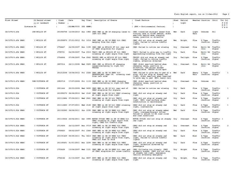
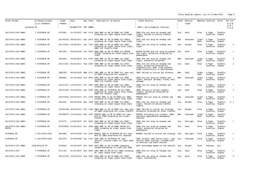
5 - 2 - No economic evaluation of the recommended measures has been undertaken as part of this study. 1.2 The CRS team The study team comprised: Steve Reddish (Traffic Planning Consultants Ltd, Hawke s Bay) Team Leader Jeff Greenough (Traffic Signals/ITS, NZTA, Wellington) Richard Hocken (Senior Sergeant District Road Policing, NZ Police, Wellington) Steve James (Senior Safety Engineer, NZTA, Wellington) Tim Kirby (Project Manager Traffic Signals, Wellington City Council) 1.3 The study methodology A package of base information related to the study sections was prepared comprising: (1) The following outputs from the NZTA crash analysis system (CAS): summary printout of the crash list (covering the time since Karo Drive was constructed in 2007 up to the present) see Appendix. crash diagram (2) Copies of the individual Traffic Crash Reports (TCRs) for crashes involving serious injury and death. (3) Aerial photos of the intersections. Using the CAS outputs, a summary of the crash record was prepared for each intersection. The team met in NZTA Wellington regional offices on the morning of Friday 23 rd November 2012 to go through the available information and consider issues. The site inspection was also undertaken that day, followed by a run through of the study findings and general agreement on the safety improvement measures to be recommended. The site inspections were carried out by initially driving along all approaches to both intersections, including using different traffic lanes, and then the team studied each intersection on foot. 1.4 Crash data A summary of the crash data is provided for each intersection in the relevant sections of the report. However, as a general comment the team noted that (a) the number of crashes at the Karo Drive/Victoria Street intersection due to red light running is noticeably higher than would normally be expected at a busy urban signalised intersection, whilst (b) the recorded crashes at the Karo Drive/Willis Street intersection were atypically low for an urban signalised intersection.
6 Traffic volumes Karo Drive carries in the order of 25,000 vehicles per day (vpd) at the intersection with Victoria Street and 28,000 vpd at the intersection with Willis Street. Victoria Street approaching Karo Drive carries approximately 13,000 vpd and Willis Street approaching Karo Drive carries approximately 11,000 vpd. Both intersections are also busy pedestrian routes into the city.
.")
7 Karo Drive/Victoria Street intersection 2.1 Site Description As noted in section 1.1, Karo Drive is one-way westbound whilst Victoria Street is oneway southbound. The two roads do not intersect at 90 due to the curvature of Karo Drive (see Figure 2). The current intersection layout can clearly be seen in Figure 3, with three westbound through lanes on Karo Drive and two southbound through lanes on Victoria Street. The double right turn lane from Victoria Street is signalised whilst the left turn lane from Karo Drive is priority controlled (Give Way). There are signalised pedestrian crossings on all signal controlled legs of the intersection and these operate in parallel with the relevant vehicle phases. A zebra crossing is provided across the Karo Drive left turn slip lane. The Victoria Street through and right turn approaches operate on the same phase of the traffic signals. Both these Victoria Street movements start simultaneously. Figure 2

8 Crash history Figure 3 1 fatal crash April 2011 motorcyclist westbound on Karo Drive went through red light at 4pm on a Saturday hit a car southbound on Victoria Street weather fine, dry road. 1 serious injury crash June 2009 bus southbound on Victoria Street went through red light at 10am on a Monday hit a car westbound on Karo Drive weather fine, dry road. A total of 44 crashes have been recorded at the intersection (1 fatality, 2 serious injury casualties, 28 minor injury casualties): 32 crashes were side impact: 18 where Karo Drive driver failed to stop for red 14 where Victoria Street driver failed to stop for red 8 rear end crashes 0 pedestrian crashes 2 crashes due to changing lanes Note: All but 4 of the minor injury casualties were involved in the side impact crashes 17 (53%) of the 32 side impact crashes involved injury
9 (56%) of the 32 (56%) side impact crashes were at night during times of low traffic flow (9 were where the at fault driver was exiting Karo Drive, 9 with them exiting Victoria Street) 2.3 Issues observed 1. Significant red light running from both Karo Drive and Victoria Street approaches is evidenced by the crash data. 2. The curvature of the Karo Drive approach coupled with buildings on the inside of the curve and the open area on the outside of the curve mean that the intersection at Victoria Street is not easily definable as an intersection in advance, compared to seeing the Cuba Street intersection, for example, when proceeding along Karo Drive (see Photo 1). When leaving the Cuba Street intersection westbound on Karo Drive, the Victoria Street intersection is not visible (see Photo 2) and neither the full array of signals nor the layout of the intersection can be seen from half way between Cuba Street and Victoria Street (see Photo 3). In addition, the limit line on Karo Drive cannot be seen in advance due to a slight vertical curvature in the carriageway. If some drivers do not register the signalised intersection ahead, there is the risk of them proceeding though a red signal display. 3. In addition to the curvature of Karo Drive affecting advance visibility and recognition of the intersection ahead, the building and infrastructure at the northeast corner of the intersection mean that drivers do not see the northern leg of Victoria Street or the traffic on it (see Photos 4 and 5). This can exacerbate the perception of the intersection and also means that drivers on either the Karo Drive or Victoria Street approaches would not get an early view of any vehicle proceeding through a red signal on the conflicting approach. 4. The positioning of the limit line for the double right turn from Victoria Street into Karo Drive means that the driver of the vehicle in the right hand lane of the two right turn lanes will often not be able to see any vehicle on Karo Drive that may have proceeded late or through a red signal through at the intersection due to his/her visibility being blocked by a vehicle in the left hand lane of the two right turn lanes. Equally the driver on Karo Drive would not see the vehicle in the right hand lane of the two right turn lanes. 5. On Victoria Street, only 60m separates the signalised intersections of Abel Smith Street and then Karo Drive (see Figure 3 and Photo 6). It would normally be expected that the linking of the signals would be that Abel Smith Street goes red before Karo Drive, giving drivers green signal progression through these two sets of


10 - 7 - signals. Observation was that Karo Drive sometimes displayed red before or concurrently with Abel Smith Street this can generate the risk of drivers expecting progression and proceeding though a red signal display at Karo Drive. 6. The mast arm outreach lantern is aimed well left of the optimum location although it is still fully visible from the safe stopping distance. Photo 1 Karo Drive approaching Cuba Street Photo 2 Karo Drive leaving Cuba Street

 Photo 5 Karo")

11 - 8 - Photo 3 Karo Drive approaching Victoria Street Photo 4 Karo Drive approaching Victoria Street (1) Photo 5 Karo Drive approaching Victoria Street (2)

12 Recommendations Photo 6 Victoria Street approaching Abel Smith Street a. Install red light cameras on both the Karo Drive and the Victoria Street approaches to the intersection together with associated warning signage. b. Consider the installation of alternative technology for warning motorists on Karo Drive of the traffic signals ahead, such as electronic advance warning signs that convey the message Prepare to Stop prior to the signals changing to red (NB at other times the signs are blank). c. Improve the awareness for drivers on Karo Drive of the upcoming intersection at Victoria Street by: (1) installing an additional mast arm signal display on the right hand side at the primary signal pole position; (2) installing coloured surfacing on the carriageway containing signals ahead message; (3) using calcined bauxite on the approach to the intersection to both highlight the intersection and improve stopping ability; (4) positioning and improving the limit line so that it can be clearly seen; (5) realigning & tilting down the existing overhead signal lantern so it faces the road centreline at 100m from the limit line and is more conspicuous to a driver at that location 1. 1 This has now ben actioned by Wellington City Council
13 d. In conjunction with Wellington Inner City Bypass works improve the visibility of the full intersection on the Karo Drive approach; in particular improve visibility at the NE corner so that drivers on both the Karo Drive and Victoria Street approaches can see each other as well as the intersection being more obvious. e. Stagger the limit lines for the two lanes of the double right turn from Victoria Street onto Karo Drive to improve the intervisibility between vehicles on Karo Drive and the double right turn from Victoria Street. f. For periods when traffic flows are low (eg night time) and there is no demand registered at the signals, consider implementing a rest on red condition. g. Review the phasing of the linking on Victoria Street from Abel Smith Street through Karo Drive to minimise the risk of Victoria Street drivers continuing thorough Karo Drive on a red signal after crossing Abel Smith Street on a green signal 2. h. Add horizontal louvres to the overhead signal lantern (green aspect only) at the downstream intersection of Karo Drive/ Willis Street to minimise the likelihood of drivers mistaking this lantern as being part of the preceding set of signals. Tilt down the same outreach lantern for the same reason. 2 The co-ordination along Victoria Street has since been revised by Wellington city Council.

14 Karo Drive/Willis Street/Abel Smith Street intersection 3.1 Site Description As noted in section 1.1, Karo Drive is one-way westbound whilst Willis Street is oneway northbound and the fifth leg at the intersection, Abel Smith Street, is two-way. The current intersection layout can be seen in Figure 4, with two westbound through lanes on Karo Drive to The Terrace Tunnel (the left hand lane is also shared for access to Abel Smith Street) and a dedicated right turn lane into Willis Street. On Willis Street there are three lanes at the Karo Drive intersection: a dedicated left turn lane for the shared movement to Abel Smith Street and The Terrace Tunnel, a shared through and left turn (to The Terrace Tunnel) lane and a second through lane. Traffic from Abel Smith Street can turn left to The Terrace Tunnel or Willis Street, though the former movement is difficult to undertake and only suitable for smaller vehicles. There are signalised pedestrian crossings on all legs of the intersection and these operate in parallel with the relevant vehicle phases. Each of the three vehicular approaches operates on a separate phase of the traffic signals. 3.2 Crash history Figure 4 1 fatal crash October 2007 driver went the wrong way down Willis Street (ie from the north) and into the Karo Drive intersection at midnight on a Wednesday hit a car westbound on Karo Drive weather fine, dry road. 1 serious injury crash July 2008 intoxicated driver lost control northbound on Willis Street prior to Karo Drive and hit a power pole in Willis Street.
 3.")
15 A total of 17 crashes have been recorded at the intersection (1 fatality, 1 serious injury, 6 minor injury casualties): 4 crashes were side impact: 2 where Karo Drive driver failed to stop for red 2 where Willis Street driver failed to stop for red 3 rear end crashes 3 pedestrian crashes 4 crashes due to changing lanes or turning from the wrong lane (to access Abel Smith Street) 3.3 Issues observed 1. The 5-leg intersection layout is confusing for some users and lane guidance through the intersection is poor (see Photo 7). 2. The speed limit signs on the Terrace Tunnel gantry at the intersection can encourage higher speeds on Karo Drive prior to and through the intersection which in turn can lead to red light running and/or rear end crashes (see Photo 8). Photo 7 Lack of tracking/continuity lines within Karo Drive/Willis Street intersection

16 Recommendations Photo 8 Speed limit signs on gantry a. Install additional lane continuity (tracking) lines through the intersection for movements from both Willis Street and Karo Drive. b. Default the speed limit signs on The Terrace Tunnel gantry at Willis Street to a blank display unless the tunnel speed limit is to be 50 km/h or less. c. Install a red light camera on the Karo Drive approach to the intersection together with associated warning signage.
17 APPENDIX
18
19
20
21
Napier City road trauma for Napier City. Road casualties Estimated social cost of crashes* Major road safety issues.
 ISSN 1176-841X July 25 Land Transport New Zealand has prepared this road safety issues report. It is based on reported crash data and trends for the 2 24 period. The intent of the report is to highlight
TERM CONTRACT FOR THE MANAGEMENT AND MAINTENANCE OF THE SCOTTISH TRUNK ROAD NETWORK NORTH EAST UNIT
 TERM CONTRACT FOR THE MANAGEMENT AND MAINTENANCE OF THE SCOTTISH TRUNK ROAD NETWORK NORTH EAST UNIT A90 LAURENCEKIRK ROAD SAFETY SCHEME MONITORING STUDY Client: Transport Scotland Trunk Road and Bus Operations
WHANGAREI IMPROVEMENTS
 WHANGAREI IMPROVEMENTS PROJECT OVERVIEW The NZ Transport Agency (NZTA) is working with Whangarei District Council (WDC) to improve the state highway through Whangarei. In addition to the recently completed
Improving Cyclist Safety at the Dundas Street West and Sterling Road Intersection
 STAFF REPORT ACTION REQUIRED Improving Cyclist Safety at the Dundas Street West and Sterling Road Intersection Date: August 17, 2012 To: From: Wards: Reference Number: Public Works and Infrastructure Committee
Transport Assessment. Curtis Street Plan Change
 Transport Assessment Curtis Street Plan Change Transport Assessment for Curtis Street Plan Change i Contents 1. Introduction... 1 2. Existing Conditions... 2 2.1 Location... 2 2.2 Study Area... 3 2.3
Overview. Updated pictures of the intersection are shown in Exhibits 1 thru 4, and the aerial photo provided by Google Maps is shown in Exhibit 5.
 Overview The (here in after referred to as the Village ) is submitting the follow up interim RLRC Safety Report for the intersection of Lincoln Highway (US 30) at Orchard Drive. Additional reports, as
2003 road trauma for. Wairoa District. Road casualties Estimated social cost of crashes* Major road safety issues WAIROA DISTRICT JULY 2004
 WAIROA DISTRICT JULY 24 T he Land Transport Safety Authority (LTSA) has prepared this road safety issues report. It is based on reported crash data and trends for the 1999 23 period. The intent of the
AGENDA ITEM 6 D THOMASVILLE ROAD (HERMITAGE BOULEVARD TO LIVE OAK PLANTATION ROAD) ROADWAY SAFETY AUDIT
 ROADWAY SAFETY AUDIT") May 15, 2018 AGENDA ITEM 6 D THOMASVILLE ROAD (HERMITAGE BOULEVARD TO LIVE OAK PLANTATION ROAD) ROADWAY SAFETY AUDIT TYPE OF ITEM: Discussion STATEMENT OF ISSUE The Florida Department of Transportation
May 15, 2018 AGENDA ITEM 6 D THOMASVILLE ROAD (HERMITAGE BOULEVARD TO LIVE OAK PLANTATION ROAD) ROADWAY SAFETY AUDIT TYPE OF ITEM: Discussion STATEMENT OF ISSUE The Florida Department of Transportation
Bramshaw traffic calming proposal
 - 1 - Bramshaw traffic calming proposal Initial options appraisal report July 2017 - 2-1. Project background Hampshire Country Council has commissioned Test Valley Borough Council to carry out an option
PAEKĀKĀRIKI HILL ROAD / BEACH ROAD / SH1 INTERSECTION PROGRESS REPORT
 Chairperson and Committee Members ENVIRONMENT AND COMMUNITY DEVELOPMENT COMMITTEE 6 DECEMBER 2011 Meeting Status: Public Purpose of Report: For Decision PAEKĀKĀRIKI HILL ROAD / BEACH ROAD / SH1 INTERSECTION
A105 Green Lanes junction with Bourne Hill / Hedge Lane
 Cycle Enfield - Section 5 A105 Green Lanes junction with Bourne Hill / Hedge Lane Stage 2 Road Safety Audit Ref: 2759.03.05/032/A105/BOR/2016 Prepared for: London Borough of Enfield By: Road Safety Audit,
Stops & Goes. of Traffic Signals
 Stops & Goes of Traffic Signals A Traffic Signal Auditors Perspective November 2004 ISBN 0-478-25367-2 2004, Transfund New Zealand P O Box 2331, Wellington, New Zealand Telephone +64 (04) 916 4220 Facsimile
Draft letter to Designers and Managing Agents INTERIM ADVICE NOTE 43/02: CANTILEVER AND PORTAL GANTRY VMS
 Draft letter to Designers and Managing Agents INTERIM ADVICE NOTE 43/02: CANTILEVER AND PORTAL GANTRY VMS This Interim Advice Note announces amendments to a series of guidelines related to cantilever and
1 This technical note considers the issues associated with the use of tidal flow bus lanes on key public transport corridors in Cambridge.
 TECHNICAL NOTE: TIDAL FLOW BUS LANE OPTION ASSESSMENT Purpose 1 This technical note considers the issues associated with the use of tidal flow bus lanes on key public transport corridors in Cambridge.
The Safe System Approach
 There are very few areas of public discussion and sentiment which generate as much consensus as road safety. Everyone wants safer roads for all users, and road safety is a key priority for governments,
M9/A90/M90 Edinburgh to Fraserburgh Trunk Road. A90 Tealing. Moving Cursor Programme Junction Study
 A90 Tealing Moving Cursor Programme Junction Study This is an unpublished report prepared for the Transport Scotland, Trunk Road and Bus Operations Division (TRBO) and must not be referred to in any publication
Co-ordinator Transportation Committee. Director, Mobility Services and Corporate Fleet Services Environment and Transportation Department
 28 REGIONAL MUNICIPALITY OF OTTAWA-CARLETON MUNICIPALITÉ RÉGIONALE D OTTAWA-CARLETON REPORT RAPPORT Our File/N/Réf. Your File/V/Réf. 25 23-97-R016 DATE 15 April 1997 TO/DEST. FROM/EXP. SUBJECT/OBJET Co-ordinator
MILTON ROAD ~ MITCHAM'S CORNER PARAMICS MODEL INITIAL OPTION TESTING
 MILTON ROAD ~ MITCHAM'S CORNER PARAMICS MODEL INITIAL OPTION TESTING NOVEMBER 216 MILTON ROAD ~ MITCHAM'S CORNER PARAMICS MODEL INITIAL OPTION TESTING Cambridgeshire County Council Type of document (version)
Harriet Fraser Traffic Engineering & Transportation Planning
 Appendix 5: Traffic Assessment 71 26 February 2015 Mr James Beban Senior Resource Consents Planner Cuttriss Consultants Ltd PO Box 30429 Lower Hutt PO Box 40170 Upper Hutt 5140 P 04 526 2979 M 027 668
CITY OF OTTAWA ROADWAY MODIFICATION APPROVAL UNDER DELEGATED AUTHORITY
 RMA-2015-ATM-038 CITY OF OTTAWA ROADWAY MODIFICATION APPROVAL UNDER DELEGATED AUTHORITY DATE: April 22, 2015 SUBJECT Approval of Roadway Modifications Recommended through an Area Traffic Management Study
Evaluation of M-99 (Broad Street) Road Diet and Intersection Operational Investigation
 Road Diet and Intersection Operational Investigation") Evaluation of M-99 (Broad Street) Road Diet and Intersection Operational Investigation City of Hillsdale, Hillsdale County, Michigan June 16, 2016 Final Report Prepared for City of Hillsdale 97 North Broad
Evaluation of M-99 (Broad Street) Road Diet and Intersection Operational Investigation City of Hillsdale, Hillsdale County, Michigan June 16, 2016 Final Report Prepared for City of Hillsdale 97 North Broad
Deaths/injuries in motor vehicle crashes per million hours spent travelling, July 2007 June 2011 (All ages) Mode of travel
 Mode of travel") Cyclists CRASH STATISTICS FOR THE YEAR ENDED 31 DECEMBER 211 Prepared by the Ministry of Transport CRASH FACTSHEET 212 Cyclists have a number of risk factors that do not affect car drivers. The main risk
Cyclists CRASH STATISTICS FOR THE YEAR ENDED 31 DECEMBER 211 Prepared by the Ministry of Transport CRASH FACTSHEET 212 Cyclists have a number of risk factors that do not affect car drivers. The main risk
road safety issues 2001 road toll for Gisborne district July 2002 Road user casualties Estimated social cost of crashes*
 GISBORNE DISTRICT road safety issues July 22 The Land Transport Safety Authority (LTSA) has prepared this Road Safety Issues Report. It is based on reported crash data and trends for the 1997 21 period.
Forest Hills Improvement Initiative
 Forest Hills Improvement Initiative Transportation Action Plan Short Term Recommendations ONLY Final Draft as of April 30, 2008 For Community Review and Feedback Prepared for: The City of Boston Boston
People killed and injured per million hours spent travelling, Motorcyclist Cyclist Driver Car / van passenger
 Cyclists CRASH FACTSHEET 27 CRASH STATISTICS FOR THE YEAR ENDED 31 DEC 26 Prepared by Strategy and Sustainability, Ministry of Transport Cyclists have a number of risk factors that do not affect car drivers.
Accommodating Cyclists at Signalised Intersections
 Accommodating Cyclists at Signalised Intersections Axel Wilke Senior Traffic Engineer, Christchurch City Council Axel.Wilke@ccc.govt.nz Glen Koorey Transportation Lecturer, University of Canterbury Glen.Koorey@canterbury.ac.nz
Extending 200m either side of the intersection Te Mata Mangateretere/ Waimarama/ Te Mata/River Rd
 RCA consent (eg CAR/WAP) and/or RCA contract reference TRAFFIC MANAGEMENT PLAN (TMP) FULL FORM Use this form for complex activities. Refer to the NZ Transport Agency s Traffic control devices manual, part
SPEED CONTROL AT ROUNDABOUTS USE OF MAXIMUM ENTRY PATH RADII
 23 rd ARRB Conference Research Partnering with Practitioners, Adelaide Australia, 2008 SPEED CONTROL AT ROUNDABOUTS USE OF MAXIMUM ENTRY PATH RADII Dr Owen Arndt, Queensland Department of Main Roads, Australia
Understanding school road safety
 Understanding school road safety 1. The purpose of these guidelines The safety of students travelling to and from school is one of the most important issues for school communities. Road environments around
Road Safety Trends, Targets and Safety Programs in New Zealand. by Dr Shane Turner
 Road Safety Trends, Targets and Safety Programs in New Zealand by Dr Shane Turner New Zealand Kiwi s vs Aussies Outline Land transport organisations NZ & US crash/accident trends NZ safety targets & priorities
The Ins and Outs of Roundabouts
 The Ins and Outs of Roundabouts Safety Auditors Perspective April 2000 TABLE OF CONTENTS PAGE Preface 3 Introduction 4 Road Safety Audits 5 List of Common Road Safety Problems at Roundabouts 6 Commonly
ROAD SAFETY PERFORMANCE REVIEW Capacity Building Workshop for Uganda. irap METHODOLOGY Racheal M. N. Nganwa AfricaRAP Lead 1 & 2 March 2018
 ROAD SAFETY PERFORMANCE REVIEW Capacity Building Workshop for Uganda irap METHODOLOGY Racheal M. N. Nganwa AfricaRAP Lead 1 & 2 March 2018 About irap: Registered charity Vision: a world free of high risk
Section Outline Signalised Intersection Layout
 Advanced Planning and Design for Cycling Module 4 Intersections SECTION 2 SIGNALISED INTERSECTION LAYOUT Section Outline Signalised Intersection Layout Refresher: 6 elements of intersection design Providing
Traffic Study of Fuller Street, Cady Street, West Street and West Avenue. Final Report
 Traffic Study of Fuller Street, Cady Street, West Street and West Avenue Final Report July 2005 Prepared for: Town of Ludlow Prepared by: Pioneer Valley Planning Commission 26 Central Street West Springfield,
Rhebogue Neighbourhood Greenway. Road Safety Audit Stage 2
 Rhebogue Neighbourhood Greenway Road Safety Audit Stage 2 Report Number: 12/007/00/00057 July 2014 Mid West National Road Design Office Lissanalta House, Dooradoyle County Limerick Tel: 061 496 800 Fax:
BUILDING CHINARAP. Zhang Tiejun Research Institute of Highway (RIOH) Beijing, China
 Beijing, China") BUILDING CHINARAP Zhang Tiejun Research Institute of Highway (RIOH) Beijing, China E-mail: tj.zhang@rioh.cn Greg Smith International Road Assessment Programme (irap) Beijing, China E-mail: greg.smith@irap.org
BUILDING CHINARAP Zhang Tiejun Research Institute of Highway (RIOH) Beijing, China E-mail: tj.zhang@rioh.cn Greg Smith International Road Assessment Programme (irap) Beijing, China E-mail: greg.smith@irap.org
Collision Site Investigation - Bodenham By-Pass Background
 Collision Site Investigation - Bodenham By-Pass Background The junction of the C12 and A338 was the subject of a Local Safety Scheme (LSS) in 2011. Analysation of the collisions at the time revealed the
FLORIDA DEPARTMENT OF TRANSPORTATION DISTRICT 7 DISTRICT WIDE BICYCLE/PEDESTRIAN ACCESS TO TRANSIT SAFETY ASSESSMENT AND IMPROVEMENT PLAN
 FLORIDA DEPARTMENT OF TRANSPORTATION DISTRICT 7 DISTRICT WIDE BICYCLE/PEDESTRIAN ACCESS TO TRANSIT SAFETY ASSESSMENT AND IMPROVEMENT PLAN TRANSIT SAFETY ASSESSMENT SR 55/US 19 AT 80 TH AVE N DRAFT JUNE
POLICY: TRAFFIC CALMING
 2006 MAY REFERENCE: COUNCIL APPROVED BY COUNCIL MAY 23, 2006 CITY OPERATIONS - NO. 608 POLICY: TRAFFIC CALMING A. All requests for traffic calming within the City shall be considered in accordance with
Acland Street, St Kilda
 Acland Street, St Kilda Traffic Redistribution Client: Yarra Trams Project No. 122531 Draft_4 Report 16/09/13 Suite 1, 1 st Floor 132 Upper Heidelberg Road Ivanhoe Vic 3079 PO Box 417 Ivanhoe Vic 3079
SH1 Western Belfast Bypass Transportation Assessment
 SH1 Western Belfast Bypass Transportation Assessment WBB- Transportation Assessment i This report has been prepared on behalf of the NZ Transport Agency (NZTA). No liability is accepted by this company
Statement of Rebuttal Evidence of Anthony Thomas Penny on Behalf of Danne Mora Holdings (#1134)
") In the Matter of: The Resource Management Act 1991 and In the Matter of: and The Christchurch Proposed Replacement District Plan under the Canterbury Earthquake (Christchurch Replacement District Plan)
In the Matter of: The Resource Management Act 1991 and In the Matter of: and The Christchurch Proposed Replacement District Plan under the Canterbury Earthquake (Christchurch Replacement District Plan)
Guide to Road Design Part 3: Geometric Design Session I 18 October 2016
 Guide to Road Design Part 3: Geometric Design Session I 18 October 2016 Today s moderator Angela Racz Online Training Coordinator Knowledge Transfer - ARRB Group P: +61 3 9881 1694 E: training@arrb.com.au
briefing notes - road safety issues
 briefing notes road safety Waikato District briefing notes - road safety issues Waikato District New Zealand Transport Agency has prepared this eleventh road safety issues report. It is based on reported
PLACEMENT OF SIGNS RECOMMENDED PRACTICES SUB-SECTION
 Page 1 of 6 RECOMMENDED PRACTICES PART SECTION SUB-SECTION HIGHWAY SIGNS GENERAL General Proper positioning of signs is an important element in the overall control of traffic within a roadway network.
SH1/OTAIHANGA ROAD ROUNDABOUT
 Attachment 4 MacKays to Peka Peka (M2PP) Kāpiti Expressway SH1/OTAIHANGA ROAD ROUNDABOUT ROAD SAFETY AUDIT of the DETAIL DESIGN A REPORT PREPARED FOR NZ TRANSPORT AGENCY Hawke s Bay office: PO Box 28 208,
[ Fundación PONS ] [ Fundación PONS ] [ Expertise PONS ] Investing in road safety
![[ Fundación PONS ] [ Fundación PONS ] [ Expertise PONS ] Investing in road safety](/thumbs/73/68505603.jpg "[ Fundación PONS ] [ Fundación PONS ] [ Expertise PONS ] Investing in road safety") With more than 60 years experience, PONS is a leading company in the fields of road safety and sustainable transportation planning, providing worldwide support with auditing, consultancy and training services,
With more than 60 years experience, PONS is a leading company in the fields of road safety and sustainable transportation planning, providing worldwide support with auditing, consultancy and training services,
CHECKLIST 2: PRELIMINARY DESIGN STAGE AUDIT
 CHECKLIST 2: PRELIMINARY DESIGN STAGE AUDIT 2.1 General topics 2.1.1 Changes since previous audit Do the conditions for which the scheme was originally designed still apply? (for example, no changes to
An evaluation of pedestrian countdown timers in the Sydney CBD
 An evaluation of pedestrian countdown timers in the Sydney CBD Cleaver, M. A., Hislop, J., de Roos, M. P., Fernandes, R., Prendergast, M. (NSW Centre for Road Safety) Brisbane, G., Levasseur, M., McTiernan,
C L M ccrostie. Final Year Projects, 2014 Dept. of Civil and Natural Resources Engineering University of Canterbury Project supervisor(s): G.
: G.") C L M ccrostie Final Year Projects, 2014 Dept. of Civil and Natural Resources Engineering University of Canterbury Project supervisor(s): G. Koorey Keywords:, pedestrian crosswalk, traffic laws ABSTRACT
C L M ccrostie Final Year Projects, 2014 Dept. of Civil and Natural Resources Engineering University of Canterbury Project supervisor(s): G. Koorey Keywords:, pedestrian crosswalk, traffic laws ABSTRACT
road safety issues 2002 road trauma for TNZ Region Two July 2003 Road deaths Estimated social cost of crashes* Major road safety issues
 road safety issues July 23 22 road trauma for TNZ Region Two The Land Transport Safety Authority (LTSA) has prepared this road safety issues report. It is based on reported crash data and trends for the
TGSI Tactile Ground Surface Indicators
 TGSI Tactile Ground Surface Indicators Introduction: This Design Note, No 11, provides guidelines and requirements for the use and installation of Tactile Ground Surface Indicators (TGSI s). References
Design and Installation of Low Level Cycle Signals
 Transport for London Surface Transport Management System Document Guidance Note Design and Installation of Low Level Cycle Signals Document reference: SQA-0651 - Issue: Draft out of date information. 1
TRAFFIC ACCIDENT ANALYSIS
 TRAFFIC ACCIDENT ANALYSIS Westheimer at Chimney Rock and Westheimer at Dunvale Prepared for Prepared by Klotz Associates, Inc. 1160 Dairy Ashford, Suite 500 Houston, Texas 77079 The preparation of this
At each type of conflict location, the risk is affected by certain parameters:
 TN001 April 2016 The separated cycleway options tool (SCOT) was developed to partially address some of the gaps identified in Stage 1 of the Cycling Network Guidance project relating to separated cycleways.
TECHNICAL NOTE THROUGH KERBSIDE LANE UTILISATION AT SIGNALISED INTERSECTIONS
 TECHNICAL NOTE THROUGH KERBSIDE LANE UTILISATION AT SIGNALISED INTERSECTIONS Authors: Randhir Karma NDip: Eng (Civil) B. Tech Eng (Civil) M Eng (Hons) (Transportation) Auckland Traffic Service Group Manager
Welcome. Moturoa Shops Minor Safety Improvements. Community Consultation on Options. Please complete the feedback form.
 Moturoa Shops Minor Safety Improvements Community ultation on Options Welcome We are investigating options for minor safety improvements on State Highway 44 (SH44) at the Moturoa Shops. Please have a look
ROUNDABOUTS. Improving Safety and Efficiency. SR83 & Smithville Western Rd. Joel Montgomery, PE Director of Administration
 ROUNDABOUTS Improving Safety and Efficiency SR83 & Smithville Western Rd. Joel Montgomery, PE Director of Administration The Ohio Department of Transportation District 3 906 North Clark Ave. Ashland, OH
BD RESOLUTION NO RESOLUTION ADOPTING THE VISION ZERO RAMP INTERSECTION STUDY PHASE 1
 BD00 RESOLUTION NO. - RESOLUTION ADOPTING THE VISION ZERO RAMP INTERSECTION STUDY PHASE [NTIP PLANNING] FINAL REPORT WHEREAS, The Vision Zero Ramp Intersection Study Phase was recommended by Commissioner
The existing site constraints which may be encountered for the A428 scheme proposals are divided into sections as follows.
 Project: A428 Study To: Cambridgeshire County Council Subject: Tidal Bus lane Review From: Atkins Date: 24 May 2016 cc: Introduction As part of the A428 Corridor Study to improve the bus journey time between
TRAFFIC SIGNALS AND SIGNALISED ROUNDABOUTS
 TRAFFIC SIGNALS AND SIGNALISED ROUNDABOUTS Ian Routledge - OBJECTIVE OF PRESENTATION I have 32 years experience of traffic signal and systems design, implementation, operation and maintenance There are
Christchurch City Council Assets & Network Unit Transport Technical Services & Design
 Date: 6 th May 2014 From: To: Bill Homewood Transportation Engineer TOC Subject: Main South Road / Carmen Road Optimisation Budget Category: Network Optimisation Appendices Appendix 1 - Turning Counts
BENNING ROAD & BRIDGES TRANSPORTATION IMPROVEMENTS CRASH DATA AND SAFETY ANALYSIS TECHNICAL MEMORANDUM DRAFT MAY 2016
 BENNING ROAD & BRIDGES TRANSPORTATION IMPROVEMENTS CRASH DATA AND SAFETY ANALYSIS TECHNICAL MEMORANDUM DRAFT MAY 2016 This page left intentionally blank. Table of Contents 1.0 Introduction... 1 1.1 Crash
Traffic Control Signals Review 4325 McCowan Road
 REPORT FOR ACTION Traffic Control Signals Review 4325 McCowan Road Date: March 15, 2018 To: Scarborough Community Council From: Director, Transportation Services, Scarborough District Wards: Ward 41 Scarborough
Agenda. Introduction to Roundabouts. Introduction to Roundabouts. Introduction to Roundabouts 6/6/2018
 PROPOSED PROJECT 161-003 SAFETY AND OPERATIONAL IMPROVEMENTS TO THE INTERSECTION OF ROUTE 106 (NEW CANAAN ROAD) AND BELDEN HILL ROAD Connecticut Department of Transportation Representatives Division of
PUBLIC AGENDA TRAFFIC SAFETY COMMITTEE. Tuesday, January 12, 2016, 8:45 a.m. Committee Room E, Ground Floor, City Hall Members
 PUBLIC AGENDA TRAFFIC SAFETY COMMITTEE Tuesday, January 12, 2016, 8:45 a.m. Committee Room E, Ground Floor, City Hall Members Mr. K. Claffey, Chair Ms. C. Janzen, Vice Chair Councillor A. Iwanchuk Sergeant
Feasibility of Implementing International "Pedestrian Crosswalk" Laws in New Zealand Dr Glen Koorey & Courtney McCrostie University of Canterbury
 IPENZ Transportation Conference 2015 Feasibility of Implementing International "Pedestrian Crosswalk" Laws in New Zealand Dr Glen Koorey & Courtney McCrostie University of Canterbury Presentation Outline
DYNAMIC LANES FOR AUCKLAND
 Dynamic Lanes for Auckland MENEZES M. and INMAN R. Page 1 DYNAMIC LANES FOR AUCKLAND Authors: INMAN, Robert BA (Hons) Previously Auckland Transport Senior Traffic Engineer Now Aurecon Robert.Inman@aurecongroup.com
SH6 Blenheim to Nelson
 SH6 Blenheim to Nelson November 2017 Community engagement report Copyright information This publication is copyright NZ Transport Agency. Material in it may be reproduced for personal or in-house use without
RC25777 PROPOSED SERVICE CENTRE, 25 TE ARAHORI STREET, TURANGI REVIEW OF TRAFFIC ASSESSMENT FINAL
 19 April 2018 Louise Wood Senior Resource Consents Planner Taupō District Council Private Bag 2005 Taupō 3352 Gray Matter Ltd 2 Alfred Street PO Box 14178 Hamilton, 3252 Tel: 07 853 8997 170_02 Dear Louise
NZ Transport Agency Safer journeys for schools: guidelines for school communities 2
 NZ Transport Agency Safer journeys for schools: guidelines for school communities 2 Understanding road risk around schools 1. The purpose of these guidelines The safety of students travelling to and from
Response to further information request Ministry of Education Notice of Requirement (200 & 252 Park Estate Road)
") 21 Pitt Street PO Box 6345, Auckland 1141, New Zealand T: +64 9 300 9000 // F: +64 9 300 9300 E: info@beca.com // www.beca.com Auckland Council Private Bag 92300 Victoria Street West Auckland 1142 15 August
21 Pitt Street PO Box 6345, Auckland 1141, New Zealand T: +64 9 300 9000 // F: +64 9 300 9300 E: info@beca.com // www.beca.com Auckland Council Private Bag 92300 Victoria Street West Auckland 1142 15 August
Traffic Signal Phasing Study Summary & Staff Recommendations
 Traffic Signal Phasing Study Summary & Staff Recommendations Consultant Study by Skipper Consulting, Inc. Staff Committee Recommendations by Randy Pewitt, Executive Director of Emergency Mgt. and Safety
Ministry of Education Flat Bush School Notice of Requirement. Integrated Transportation Assessment Report. February 2016
 Ministry of Education Flat Bush School Notice of Requirement Integrated Transportation Assessment Report February 2016 TDG Ref: 12988-2 151105 ita flat bush.docx Ministry of Education Flat Bush School
Mandan Commission Meeting August 2, 2016 Mandan City Hall
 Mandan-Bismarck Corridor Improvement Study Mandan Commission Meeting August 2, 2016 Mandan City Hall 2014 HDR, Inc., all rights reserved. Mandan Corridors Study Schedule 2015 2016 Study Kick Off August
RIGHT TURNS AT INTERSECTIONS: ARE THERE ALTERNATIVES?
 RIGHT TURNS AT INTERSECTIONS: ARE THERE ALTERNATIVES? R.C. Pyke, J.D. Sampson and K.G. Schmid Stewart Scott International, P O Box 784506, Sandton, 2146 TTT Africa, P.O.Box 109, Sunninghill, G.D.P.T.R.W,
Amendments to Essex Highway Maintenance Strategy Maintenance Policy and Standards April 2008
 Amendments to Essex Highway Maintenance Strategy Maintenance Policy and Standards April 2008 The following amendments to the wording of the maintenance strategy apply following the revised maintenance
Edgemont Village Traffic and Parking Technical Report January 2014
 Edgemont Village Traffic and Parking Technical Report January 2014 In the fall of 2013, the District of North Vancouver engaged consultants to assess existing intersection and parking conditions in Edgemont
21. CHRISTCHURCH CYCLE LANES: PROPOSED COLOURED SURFACING CHANGE
 21. CHRISTCHURCH CYCLE LANES: PROPOSED COLOURED SURFACING CHANGE General Manager responsible: General Manager City Environment, DDI 941-8608 Officer responsible: Transport and Greenspace Manager Author:
133 rd Street and 132 nd /Hemlock Street 132 nd Street and Foster Street MINI ROUNDABOUTS. Overland Park, Kansas
 133 rd Street and 132 nd /Hemlock Street 132 nd Street and Foster Street MINI ROUNDABOUTS Overland Park, Kansas September 1, 2017 TABLE OF CONTENTS 1. INTRODUCTION... 1 2. LITERATURE REVIEW... 1 3. CONCEPT
List of Display Boards
 List of Display Boards Welcome Introduction Municipal Class Environmental Assessment (EA) Process Need and Justification for an Interchange Alternatives for Evaluation Vertical and Horizontal Alignments
Bus and Transit Lane Review Update
 Board Meeting / 25 February 2013 Agenda Item no.8(i) Bus and Transit Lane Review Update Glossary Auckland Transport New Zealand Transport Agency Transit Two Transit Three (AT) (NZTA) (T2) (T3) Executive
Road Markings. Lecture Notes in Transportation Systems Engineering. Prof. Tom V. Mathew
 Road Markings Lecture Notes in Transportation Systems Engineering Prof. Tom V. Mathew 1 Overview The essential purpose of road markings is to guide and control traffic on a highway. They supplement the
ATTACHMENT NO. 11. RRLRT No. 2. Railroad / Light Rail Transit Technical Committee TECHNICAL COMMITTEE: Busway Grade Crossings STATUS/DATE OF ACTION
 ATTACHMENT NO. 11 RRLRT No. 2 TECHNICAL COMMITTEE: TOPIC: Railroad / Light Rail Transit Technical Committee Busway Grade Crossings STATUS/DATE OF ACTION RRLRT TC Draft: 06/23/2011 RRLRT TC Approval: 06/27/2014
INDUSTRIAL BUILDING 1660 COMSTOCK ROAD CITY OF OTTAWA TRANSPORTATION OVERVIEW. Prepared for:
 INDUSTRIAL BUILDING 1660 COMSTOCK ROAD CITY OF OTTAWA TRANSPORTATION OVERVIEW Prepared for: Simluc Contractors Limited 2550 Blackwell Street, Ottawa K1B 5R1 October 18, 2013 113-584 Overview_1.doc D. J.
Chicago Safe Routes to School Safe Routes to High School (SRTS/SRTHS)
") Chicago Safe Routes to School Safe Routes to High School (SRTS/SRTHS) Marshall Community High School and Faraday Elementary School Recommended Improvements Agenda Goals Related Programs Project Location/Area
Chicago Safe Routes to School Safe Routes to High School (SRTS/SRTHS) Marshall Community High School and Faraday Elementary School Recommended Improvements Agenda Goals Related Programs Project Location/Area
2007 TRAFFIC SIGNAL PRIORITY LIST SUMMARY OF STAFF RECOMMENDATIONS TO PEDESTRIAN/BICYCLE/MOTOR VEHICLE COMMISSION.
 Traffic Engineering and Parking Divisions David C. Dryer, City Traffic Engineer and Parking Manager 215 Martin Luther King, Jr. Boulevard P.O. Box 2986 Madison, Wisconsin 53701-2986 Phone 608 266 4761
Reducing Speed: The C-Roundabout
 Reducing Speed: The C-Roundabout Ivan Jurisich (PRESENTER) NZCE (Civil) BSc(Maths) MPhil (Civil Eng) Member of ITE Traffic Engineering Solutions Ltd Phone: +649 366 7532 Email: ivan.jurisich@tes.net.nz
Introduction Methodology Study area and data collection Results and recommendation Conclusion References
 Introduction Methodology Study area and data collection Results and recommendation Conclusion References It is formal procedure for assessing accident potential and safety performance in the provision
SECTION 12 ROAD MARKINGS AND DELINEATION
 SECTION 12 20 June 2009 Part 3: Motorways and Expressways CONTENTS Reference Page Page Number Date SECTION 12: MARKINGS AND DELINEATION 12.1 GENERAL... 12-1 June 2009 12.1.1 INTRODUCTION... 12-1 June 2009
Sardis Elementary School Road Safety Plan. Produced by: Sardis Elementary School - Safer School Travel Team in cooperation with Safer City
 Sardis Elementary Road Safety Plan Produced by: Sardis Elementary - Safer Travel Team in cooperation with Safer City Plan completed in January 2016 1 Acknowledgements It takes commitment and community
102 Avenue Corridor Review
 February 26, 2015 102 Avenue Corridor Review Transportation Association of Canada Road Safety Engineering Award Submission for the City of Edmonton Introduction Transportation Association of Canada Road
A127/A130 Fairglen Interchange Improvement Schemes. Information Leaflet February 2017
 A127/A130 Fairglen Interchange Improvement Schemes Information Leaflet February 2017 1 2 Foreword By Councillor Kevin Bentley Essex is continuing to grow as a vibrant economic hub and as a fantastic place
Generic Safe Method for placing TTM on MM-ALR
 Summary 1. This paper describes a generic safe method for setting up and taking down Temporary Traffic Management (TTM) on Managed Motorway All Lane Running (MM-ALR) schemes. 2. An understanding of how
Public Information Centre
 WELCOME Public Information Centre Father Tobin Road Lougheed Middle School - Library Wednesday November 7, 2012 7:00 p.m.to 9:00 p.m. Please sign in Neighbourhood Traffic Calming Guide Background The City
Memorandum. Sunday, July 13, Saturday, July 19, 2014
 Memorandum To: David Lowin, Brooklyn Bridge Park Corporation From: Daniel Schack, AICP, PTP Date: Re: Brooklyn Bridge Park Pier 5/6 Loop Road Traffic Study Project No: 14-01-2407 At the request of Brooklyn
Keeping you connected
 Roads of national significance Wellington Northern corridor Mt Victoria Tunnel Duplication Issue 01 Keeping you connected Making changes that support a thriving Wellington is at the heart of the proposed
Woodward Hill Elementary School School Safety and Operation Review
 Address: 6082-142 nd Street Surrey, BC, V3X 1C1 Site Visit: March 7, 2011 Principal Anne Mackie Report Date: November 25, 2011 Phone: (604) 594-2408 Email: Mackie_A@sd36.bc.ca The following report is one
PROPOSED RESIDENTIAL SUBDIVISION
 PROPOSED RESIDENTIAL SUBDIVISION PART OF TARNEIT ROAD & 1121 DOHERTYS ROAD, TARNEIT Prepared For: TCG (RM) Developments Pty Ltd MARCH 2014 OUR REF: 16740R#1 PROPOSED RESIDENTIAL SUBDIVISION PART OF TARNEIT
SH3 Waitara to Bell Block
 SH3 Waitara to Bell Block NZ Transport Agency August 2017 Community feedback report Copyright information This publication is copyright NZ Transport Agency. Material in it may be reproduced for personal