DES MOINES AREA MPO. Presentation to Iowa Commercial Real Estate Association. April 6, 2017
|
|
|
- Simon Douglas
- 6 years ago
- Views:
Transcription
1 DES MOINES AREA MPO Presentation to Iowa Commercial Real Estate Association April 6, 2017
2 Presentation Outline MPO Overview Trends We re Watching Plans, Projects, Initiatives, Regional Transportation Priorities Other Major Transportation Projects
3 An Overview DES MOINES AREA MPO

4 Des Moines Area MPO Serving local governments of Central Iowa with 20 voting members: 16 cities 3 counties DART Plus advisory members: 3 cities 1 county
5 What the MPO Does Identify short- and long-range transportation planning needs Analyze and evaluate transportation improvements Estimate future traffic volumes Inform the public about MPO planning activities Study the movement of traffic along major corridors Conduct planning studies (transportation and non transportation) Identify and share best planning practices Award funding to projects
6 What the MPO Does NOT Do Road/bridge design, construction, and repair Enforcement of traffic laws Trail construction and maintenance Transit operations Land use planning and zoning
7 What We re Watching TRENDS
8 Metro continues to grow 750,000 population by 2050 Older, more diverse 21% will be 65 or older by 2050 (11% in 2010) 31% will be non-white by 2050 (16% in 2010)

9 Employment growth 40% growth in employment 481,000 jobs by 2050 (338,000 in 2010) Fastest growing industry sectors: Natural resources and construction Education and health services

10 Percent growth by age cohorts: 2010 to 2050
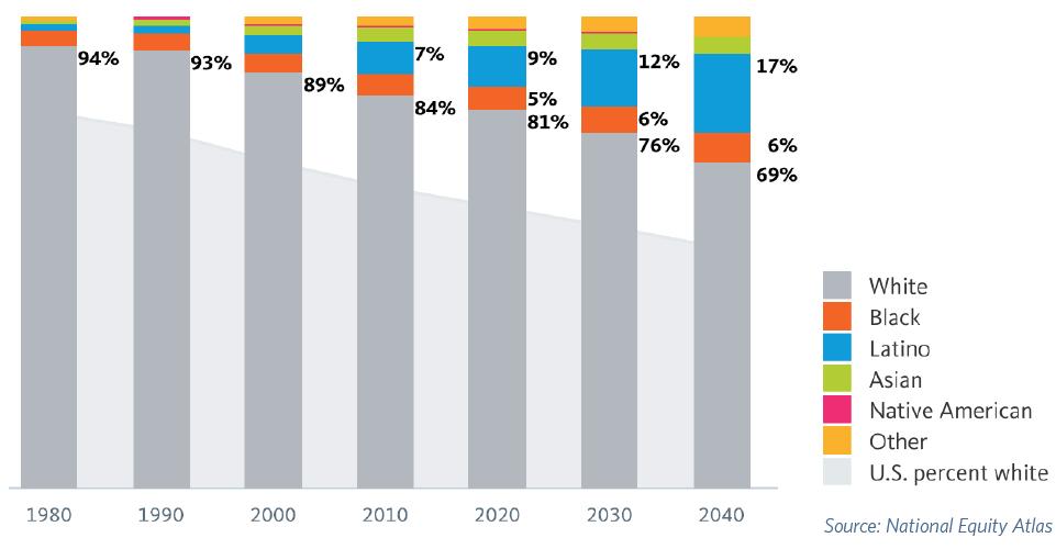
11 Racial/Ethnic Composition

12 Vehicle miles traveled are declining

13 Aging Infrastructure 18% of roads in MPO area rated Poor or Very Poor. To prevent roads from worsening, metro needs to spend $40 million annually over next 10 years at least $10 million more annually that current spending levels.


14 Pavement quality forecast based on current spending Current: Meeting regional goal Forecast: Not meeting regional goal in 10 years

15 Aging Infrastructure Currently, 100 of 409 bridges in the MPO area are considered deficient or obsolete. Tomorrow Plan: Invest in maintaining current infrastructure.

16 Declining Federal Revenue: Highway Trust Fund
17 October 2012 Random-Sample Survey Priorities of Greater Des Moines Residents #1 Priority Lower Taxes #8 Priority Create new parks and conservation areas #2 Priority Increase school funding #9/10 Priority Create new bicycle paths and facilities #3 Priority Redevelop vacant properties #9/10 Priority Buy out floodplain and convert to open space #4 Priority Enhance storm water system #11 Priority Expand the trail network #5 Priority Improve public transit #12 Priority Build major regional attraction downtown #6 Priority Spend money to attract new businesses #13 Priority Add more parking #7 Priority Support local placemaking #14 Priority Build more roads
18 What do these trends mean moving forward? Less money, Changing needs & Aging infrastructure = Funding investments in transportation need to change
19 Changes in MPO Investment Strategy Previous Allocation (Target % of Total) New Allocation (% of Total) Roadway Projects 75% max 60% max Preservation & System Optimization 10% max 10% min Bridge N/A 15% min Transit 10% max 10% min Flexible Funds N/A 5% max $578 million MPO investment through 2050 $3.28 billion total investment (local, state, federal) in transportation through 2050
20 MPO Areas of Focus PLANS, PROJECTS, INITIATIVES

21

22
23 Mobilizing Tomorrow Long-Range Transportation Plan builds from Tomorrow Plan Identifies projects, policies, and funding necessary to achieve vision for future network
24 Mobilizing Tomorrow Goals Enhance Multimodal Transportation Options Improve the Region s Environmental Health Manage and Optimize Transportation Infrastructure and Services Further the Health, Safety and Well-Being of all Residents in the Region


25 Focus Areas: Complete Streets
26 Incomplete Streets
27

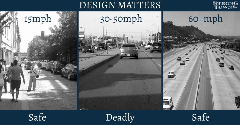
28 Why Speed Matters

29 Cycling and walking levels fell 66% between 1960 and 2009, while obesity levels increased by 156%. Percent of children who walk or bike to school fell 75% between 1960 and 2009, while childhood obesity rose 276% during the same period. Source: 2012 Benchmarking Report for Bicycling and Walking in the United States.
30 Percent of Obesity Percent Walk, Bike,Transit Obesity Walk, Bike, Transit Pucher, Walking and Cycling: Path to Improved Public Health, Fit City Conference, NYC, June 2009

31 Complete Streets Update Initiative Year 1 completed Model policy Training and best practices Wellmark Foundation Funding Mini-grants
32 Complete Street Policies Are Being Adopted Altoona Carlisle Des Moines Johnston Norwalk Pleasant Hill Urbandale Windsor Heights West Des Moines Over 850 Complete Streets policies in US State-wide policy under review


33 Step It Up DSM Collaboration with city, school and health officials. Goal: Create safe routes for kids to safely walk or bike to school, starting with 3 pilot schools. Carver Elementary Hiatt Middle School East High School

34 dmampo.org/water-trails Iowa s First Regional Water Trails Plan
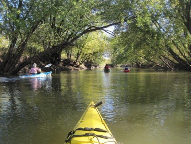


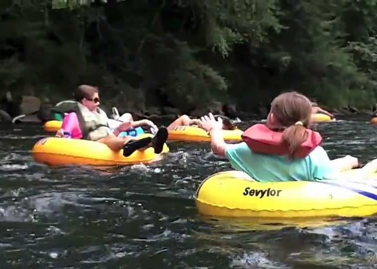
35 dmampo.org/water-trails Variety of User Experiences

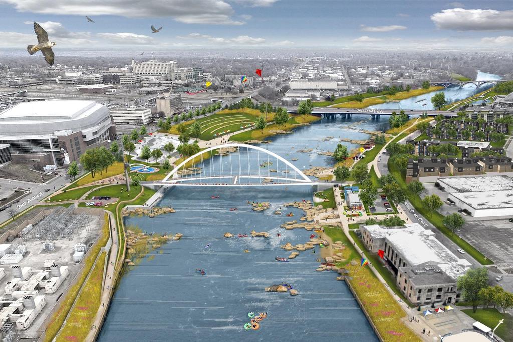
36 dmampo.org/water-trails Raccoon River: I-35 to downtown
37
38 REGIONAL TRANSPORTATION PRIORITIES
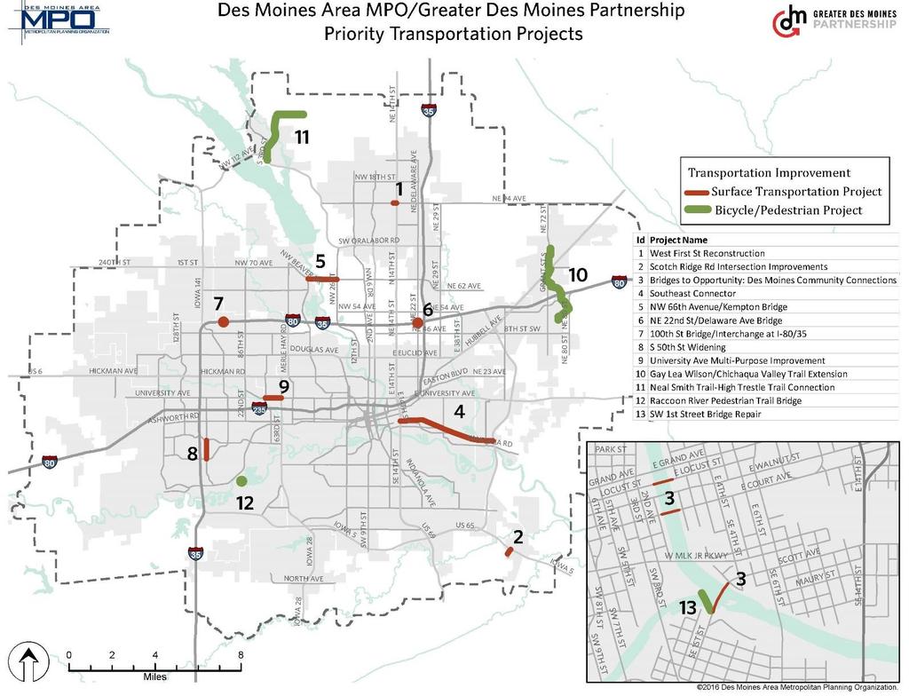
39
 and State Street, including curb-and-gutter, dedicated left turn lanes, traffic signals, shared use path, lighting, and landscaping.")
40 1. 1 st Street Reconstruction Ankeny Fully reconstruct 1 st Street between Ankeny Blvd. (US 69) and State Street, including curb-and-gutter, dedicated left turn lanes, traffic signals, shared use path, lighting, and landscaping. Total project cost: $9.1 million Federal funds received: $0 Construction: 2015

41 2. Scotch Ridge Road Intersection in Carlisle Add turn lanes and intersection improvements along the Scotch Ridge Road corridor from Bellflower to Highway 5 to improve pedestrian safety and ease increasing congestion. Total project cost: $1.5 million Federal funds received: $0 Construction: By end of 2016


42 3. Downtown Des Moines Bridges Replace, rehabilitate or upgrade bridges for Locust, Scott, SW 1st Street and Court Avenue. Total project cost: $22 million Federal funds received: $2.5 million Construction: Past 2020

43 4. Southeast Connector Des Moines to Pleasant Hill Four-lane complete street connecting Downtown Des Moines to US 65. Next phase is 30 th Street to US 65. Total project cost (30 th to US 65): $$50 million Federal funds rec d: $5 million Construction: Past 2020

44 5. NW 66 th Avenue / Kempton Bridge Polk County Reconstruction of NW 66th Avenue and the Des Moines River Bridge from NW 26th Street to NW Beaver Drive. Total project cost: $25 million Federal funds rec d: $11.4 million Construction: Approx. 2020
 Total project cost: $5.")
45 6. Replace NE 22 nd Street Bridge over I-35/80 Next phase of multi-phase, multiyear Northeast Mixmaster reconfiguration (East junction of I-35/I-80/I-235) Total project cost: $5.2 million Federal funds rec d: $0 Construction: Unknown

46 th Street at I-80/35 Construction of a bridge at 100th Street over Interstate 80/35. Total project cost: $9.5 million Federal funds rec d: $1.1 million Construction: End of 2017

47 8. South 50 th Street Widening West Des Moines Widen South 50th Street from E.P. True Parkway to Mills Civic Parkway from two lanes to five lanes. Total project cost: $5 million Federal funds rec d: $0 Construction: Approx. 2016

48 9. University Ave Improvements Windsor Heights Roadway conversion from 4 lanes to 2 lanes plus center turn lane, protected bike lanes, and on-street parking. Total project cost: $1.5 million Federal funds rec d: $320,000 Construction: Unknown


49 10. Gay Lea Wilson / Chichaqua Valley Trail Extension Construction of a 12' wide, 5 mile long extension to the Gay Lea Wilson Trail to connect the Chichaqua Valley Trail from Altoona to Bondurant. Total project cost: $7 million Federal funds rec d: $0 Construction: Past 2020

50 11. Neil Smith Trail High Trestle Trail Connection Construction of a 3.4 mile trail to connect the Neal Smith Trail to the High Trestle Trail. Total project cost: $3 million Federal funds rec d: $0 Construction: Unknown

51 12. Raccoon River Pedestrian Trail Bridge Pedestrian Bridge across the Raccoon River between Raccoon River Park and Walnut Woods State Park. Total project cost: $3 million Federal funds rec d: $0 Construction: Past 2020

52 13. Southwest 1st Street Bridge Repair Repair of historic bridge that was converted to pedestrian use in 2006 and is a link to Grays Lake Park Total project cost: $1.1 million Federal funds rec d: $0 Construction: Past 2020
53 OTHER MAJOR TRANSPORTATION PROJECTS

54 Transload Facility When open, the Transload Facility will help reduce shipping costs by as much as 50 percent for exporters within 150 miles around Des Moines by connect trucking network with four rail lines.

55 Highway 5/65 Interstate Designation Re-designating Highway 5/65 as an Interstate is seen as an important economic development strategy.

56 Veterans Parkway New four-lane road from Highway 5 to Southeast 1 st Street Connects Highway 5 to the new Microsoft datacenter development.

57 Grand Prairie Parkway New interchange opened in 2015 Connects new Kettlestone development to Interstate 80.

58 Contact: Todd Ashby Executive Director Altoona Ankeny Bondurant Carlisle Clive Dallas County Des Moines DART Grimes Johnston Mitchellville Norwalk Pleasant Hill Polk City Polk County Urbandale Warren County Waukee West Des Moines Windsor Heights
92% COMMUTING IN THE METRO. Congested Roadways Mode Share. Roadway Congestion & Mode Share
 COMMUTING IN THE METRO Roadway Congestion & Mode Share The majority of major roadways in Greater Des Moines are without congestion and have underutilized capacity. This surplus capacity could be used for
Basalt Creek Transportation Refinement Plan Recommendations
 Basalt Creek Transportation Refinement Plan Recommendations Introduction The Basalt Creek transportation planning effort analyzed future transportation conditions and evaluated alternative strategies for
City of Gainesville Transportation/Roadway Needs PROJECT SUMMARY
 A1 Roadway Resurfacing $23,846,000 TYPE: Preservation of existing system Roadway resurfacing A2 Signal Replacement $6,000,000 TYPE: Preservation of existing system Replace traffic signals. B1 W 6th St
FEDERAL FISCAL YEAR 2020 TAP PUBLIC COMMENTS
 FEDERAL FISCAL YEAR 2020 TAP PUBLIC COMMENTS Ankeny High Trestle Trail Extension Yes 14 No 1 High Trestle Trail is our St. Louis Arch. Close that gap. Yes, extend it! The High Trestle Trail is already
SAFETY OF OUR STREETS
 SAFETY OF OUR STREETS Assessing Safety Through Crash Data June 216 By analyzing crash data, the Des Moines Area Metropolitan Planning Organization (MPO) is able to help identify areas that tend to be most
UNIVERSITY AVENUE CORRIDOR REDESIGN. January 8, 2017 PUBLIC OPEN HOUSE
 January 8, 2017 PUBLIC OPEN HOUSE COLLABORATIVE COMMUNITY-BASED DESIGN IS THE FOUNDATION TO A SUCCESSFUL PROJECT AGENDA FOR TONIGHT 1 INTRODUCTIONS 2 WHY ARE WE HERE PROJECT NEED 3 SCHEDULE & GOALS 4 OPEN
City of Atlanta-MARTA Sales Tax Referendum Draft Project List. Atlanta City Council Work Session May 19, 2016
 1 City of Atlanta-MARTA Sales Tax Referendum Draft Project List Atlanta City Council Work Session May 19, 2016 2 SB 369 - MARTA Sales tax for up to 0.50% is allowed in the City of Atlanta for MARTA Purpose
SUMMARY OF TRANSPORTATION INVESTMENTS
 Santa Cruz County 2016 Measure D: Transportation Improvement Expenditure Plan - Approved by over 2/3 of Santa Cruz County voters on November 8, 2016 - Overview Measure D, the 2016 Transportation Improvement
Shenango Valley MPO. State Transportation Commission 2015 Twelve Year Program Development
 State Transportation Commission 2015 Twelve Year Program Development Regional results of the survey and public feedback from August thru November 2013 Shenango Valley MPO Version 01-2014 Mobility Concerns
BRIEFING ON PROPOSED ADDITIONS AND CHANGES Additions and Changes to Projects Proposed for Inclusion in the 2015 CLRP Update
 BRIEFING ON PROPOSED ADDITIONS AND CHANGES Additions and Changes to Projects Proposed for Inclusion in the 2015 CLRP Update January 23, 2015 Travel Forecasting Subcommittee What is the CLRP? Federally
Central Iowa Trail Condition Report DRAFT
 Central Iowa Trail Condition 2018 Report Table of Contents Acknowledgements..x Key Findings.x Introduction...........x Iowa Data Bike........x State of the Trails...........x Trail Roughness.........x
Regional Transportation Needs Within Southeastern Wisconsin
 Regional Transportation Needs Within Southeastern Wisconsin #118274 May 24, 2006 1 Introduction The Southeastern Wisconsin Regional Planning Commission (SEWRPC) is the official areawide planning agency
Bluffdale/ UDOT South High-T Intersection Project Type Operations
 Bluffdale/ UDOT 14600 South High-T Intersection Project Type Operations 14600 South and Redwood Road $ 600,000 $ 550,000 This project is to install a new High-T intersection at Redwood Road and 14600 South
Tulsa Metropolitan Area LONG RANGE TRANSPORTATION PLAN
 Tulsa Metropolitan Area LONG RANGE TRANSPORTATION PLAN Indian Nations Council of Governments August 2005 CONTACTING INCOG In developing the Destination 2030 Long Range Transportation Plan, INCOG s Transportation
Transportation Day at the Capitol. Charlie Zelle Commissioner, MnDOT Feb. 16, 2017
 Transportation Day at the Capitol Charlie Zelle Commissioner, MnDOT Feb. 16, 2017 State Transportation System Highways 59.1 billion annual vehicle miles traveled 33.1 billion on trunk highways Bridges
Route 7 Corridor Study
 Route 7 Corridor Study Executive Summary Study Area The following report analyzes a segment of the Virginia State Route 7 corridor. The corridor study area, spanning over 5 miles in length, is a multi
NEED FOR ADDITIONAL FUNDING
 Measure B BACKGROUND 2013: Vision for a supplement to Measure A that prioritizes local roads & regional capital projects Plan developed by Professional Advisory Group Consensus recently built on RT O&M
BICYCLE AND PEDESTRIAN PROGRAM
 BICYCLE AND PEDESTRIAN PROGRAM MAC July 11, 2016 Complete Streets Initiative 1 2 3 4 On-street Counter Program Step It Up DSM E-bike Policy Review Complete Streets Streets that are designed and operated
Multi Modal Transit Access Plan KIPDA ID # 239. Project Type: STUDY
 Multi Modal Transit Access Plan KIPDA ID # 239 Project Type: STUDY Description: In conjunction with the results from Project Gobility and the Transit LOS Analysis, TARC seeks to examine the possibilities
Chapter 5 Future Transportation
 Chapter 5 Future Transportation The Future Land Use Plan identifies the desired land use designations. The land uses desired for Crozet depend, in large part, on the success of the transportation system,
Chapter 7. Transportation. Transportation Road Network Plan Transit Cyclists Pedestrians Multi-Use and Equestrian Trails
 Chapter 7 Transportation Transportation Road Network Plan Transit Cyclists Pedestrians Multi-Use and Equestrian Trails 7.1 TRANSPORTATION BACKGROUND The District of Maple Ridge faces a number of unique
Welcome. Thank you for your interest in the Lewis & Clark Viaduct Concept Study
 Welcome Thank you for your interest in the Lewis & Clark Viaduct Concept Study Please use the arrows in the upper left hand corner to navigate through the presentation. Use the envelope icon to ask a question
CITY OF PORTSMOUTH PLANNING DEPARTMENT
 CITY OF PORTSMOUTH PLANNING DEPARTMENT MEMORANDUM TO: JOHN P. BOHENKO, CITY MANAGER FROM: JULIET T.H. WALKER, PLANNING DIRECTOR SUBJECT: BICYCLE / PEDESTRIAN PLAN PROGRESS UPDATE DATE: 3/13/2018 Background
FY Transportation Capital Improvement Plan Update Arlington Committee for Transportation Choices
 FY 2017-2026 Transportation Capital Improvement Plan Update Arlington Committee for Transportation Choices November 1, 2017 Forecasted Growth Arlington continues to grow with a shift towards multi-family
Engineering - Bicycle and Pedestrian
 Capital Improvement Plan Project Summary # Bikeways Program 781,000 860,000 900,000 933,000 933,000 933,000 # Cannonball Path 1,200,000-780,000 - - - # Capital City Trail - 70,000 - - 910,000 - # Goodman
TABLE OF CONTENTS. Executive Summary
 Executive Summary Background... ES-1 Pedestrian Network... ES-2 Bikeway Network... ES-2 Collision History... ES-2 Public Input... ES-4 Conclusions and Recommendations... ES-4 1. Introduction and Setting
Memorandum. From: Jakob zumfelde, Transportation Planner Date: November 7, 2018 Reference: Long Range Transportation Plan
 Charlottesville-Albemarle Metropolitan Planning Organization POB 1505, 401 E. Water St, Charlottesville, VA 22902 www.tjpdc.org (434) 979-7310 phone info@tjpdc.org email Memorum To: MPO CTAC From: Jakob
DRAFT BUENA VISTA 2020 TRANSPORTATION PLAN
 DRAFT BUENA VISTA 2020 TRANSPORTATION PLAN DEVELOPED BY THE TRANSPORTATION PLANNING DIVISION OF THE VIRGINIA DEPARTMENT OF TRANSPORTATION IN COOPERATION WITH THE U.S. DEPARTMENT OF TRANSPORTATION, FEDERAL
Hennepin County Transportation Department
 Hennepin County Transportation Department Complete Streets Design and Implementation Prepared for the Complete Streets Task Force Craig Twinem, P.E. Design Division Manager Tom Johnson, P.E. Transportation
Perryville TOD and Greenway Plan
 Perryville TOD and Greenway Plan Greenway Glossary Pathway: A bicycle and pedestrian path separated from motorized vehicular traffic by an open space, barrier or curb. Multi-use paths may be within the
STUDY ADVISORY COMMITTEE. October 8, 2015
 STUDY ADVISORY COMMITTEE October 8, 2015 Study Purpose evaluate the long-term transportation strategies and investments needed to sustain the county s economic health and quality of life in the coming
Rochester Downtown Bicycle Study 2009
 Rochester Downtown Bicycle Study 2009 Relationship of ROCOG Long Range Transportation Plan to Rochester Comprehensive Plan Regional Long Range Transportation Plan (LRTP) is prepared under the auspices
Transportation Action Plan. Transportation & Planning Committee March 14, 2016
 Transportation Action Plan Transportation & Planning Committee March 14, 2016 Planning to create a Great City Transit System Plan Zoning & Development Ordinance Centers, Corridors & Wedges Community Character
Non-Motorized Transportation 7-1
 Non-Motorized Transportation 7-1 Transportation facilities no longer mean just accommodating a vehicle powered by a combustion engine. Pedestrian and non-motorized facilities are important modes of travel
Welcome. Public Meeting. Heading 1. Heading 2. DeMers Ave. Columbia Rd. Washington St. 42nd St. 32nd Ave. Heading 3 HEADING
 Heading 1 Heading 2 Heading 3 HADING Welcome 4 Heading 5 Normal Normal Less Spacing Public Meeting Normal No Spacing Strong mphasis Intense mphasis To Do List ullet List ullet Last List ullet 2 CÞ List
Improving Mobility Without Building More Lanes
 Improving Mobility Without Building More Lanes By Mike Salisbury and Will Toor July 2017 Copyright 2017 by Southwest Energy Efficiency Project. All rights reserved. Photo: Courtesy of the Denver Post Anyone
Phone: Fax: Project Reference No. (to be filled out by MassHighway):
:") Massachusetts Highway Department District 3 Project Need Form (PNF) This form is intended to provide preliminary information about the proposed project. It is not expected that all information that is
Massachusetts Highway Department District 3 Project Need Form (PNF) This form is intended to provide preliminary information about the proposed project. It is not expected that all information that is
Incorporating Health in Regional Transportation Planning
 Mayor Karl Dean, Chairman Incorporating Health in Regional Transportation Planning Leslie A. Meehan, AICP Center TRT Intervention Webinar January 29, 2013 Objectives for Today Background About the Nashville
City of Moorhead Committee of the Whole Meeting
 City of Moorhead Committee of the Whole Meeting Corridor Study Limits Center Avenue (Red River to 8th Street) TH 10 (Red River to TH 336) TH 75 (20th Ave S to Main Avenue) 2 Study Need: Project Overview
MN 5 Corridor Performance. Current Corridor Characteristics Highway: MN AADT: 2,400 73,000
 Corridor Context The corridor runs from Norwood Young America to the connection with US 212 in Eden Prairie. The corridor serves the communities of Chanhassen, Eden Prairie, Norwood Young America, Victoria,
Kentucky s Surface Transportation System
 Kentucky s Surface Transportation System ROAD AND BRIDGE CONDITIONS, TRAFFIC SAFETY, TRAVEL TRENDS, AND NEEDS MARCH 2018 PREPARED BY WWW.TRIPNET.ORG Founded in 1971, TRIP of Washington, DC, is a nonprofit
2045 Long Range Transportation Plan. Summary of Draft
 2045 Long Range Transportation Plan Summary of Draft Fredericksburg Area Metropolitan Planning Organization The George Washington Region includes the City of Fredericksburg and the counties of Caroline,
TOWN OF WILLIAMSTON, SC BICYCLE AND PEDESTRIAN MASTER PLAN TOWN OF WILLIAMSTON, SC BICYCLE AND PEDESTRIAN MASTER PLAN
 TOWN OF WILLIAMSTON, SC BICYCLE AND PEDESTRIAN MASTER PLAN Americans Want Choices 55% of Americans would rather drive less & walk more. Transit use is growing faster than population or highway travel.
Goal 3: Foster an environment of partnerships and collaboration to connect our communities and regions to one another.
 Non-Motorized Transportation Plan (NMTP) Draft Vision, Goal and,, Tri-County Regional Planning Commission (TCRPC) Purpose The purpose of the Tri-County Regional Planning Commission (TCRPC) Non-Motorized
Building Great Neighbourhoods BONNIE DOON
 Building Great Neighbourhoods BONNIE DOON We Are Here Today To Explain the Neighbourhood Renewal Process Show you the Westwood Preliminary Design Ask for local knowledge Highlight the Local Improvement
Attachment One. Integration of Performance Measures Into the Bryan/College Station MPO FY 2019 FY 2022 Transportation Improvement Program
 Attachment One Integration of Performance Measures Into the Bryan/College Station MPO FY 2019 FY 2022 Transportation Improvement Program Introduction Begun as part of the Moving Ahead for Progress in the
WELCOME TO OPEN HOUSE # 1 June 14, 2017
 Langstaff Road Weston Road to Highway 7 Class Environmental Assessment Study WELCOME TO OPEN HOUSE # 1 June 14, 2017 Please sign in and join our mailing list Purpose of Open House #1 & Study Area York
Governor s Transportation Vision Panel
 Office of Governor Kate Brown Governor s Transportation Vision Panel JLA Public Involvement Project Overview The is a yearlong effort to develop a series of recommendations for the Governor that address
I-35W Solutions Alliance Project Update July 13, 2017
 Title I-35W Solutions Alliance Project Update July 13, 2017 Evaluating the potential for Bus Rapid Transit and MnPASS Express Lanes in the southwest Metro, Investigating options for improved bus service
Providing an Efficient and Multi-modal Transportation System
 Providing an Efficient and Multi-modal Transportation System Welcome and Introductions The Plan Process Transportation Overview Workshop Discussions Report Out and Next Steps AGENDA Comprehensive Plan
Prioritizing Transportation Policy and Funding for Active Transportation, Safety, Equity and Health
 Mayor Karl Dean, Chairman Prioritizing Transportation Policy and Funding for Active Transportation, Safety, Equity and Health Leslie A. Meehan, AICP Planning and Implementing the Active Community Webinar
Eastern PA Trail Summit October 1, 2018
 Eastern PA Trail Summit October 1, 2018 WHO WE ARE + WHY + WE RE * HERE * * * * * * Session Goals: Discuss how to coordinate planning and design in small, urbanized towns Consider how to develop alternative
PRESS RELEASE San Joaquin Council of Governments
 PRESS RELEASE San Joaquin Council of Governments For Immediate Release February 23, 2018 Contact: Nicole Gorham, 235-0582 gorham@sjcog.org SJCOG Board Awards $19.63 Million in Measure K Bicycle, Pedestrian,
Virginia Street Bus RAPID Transit Extension Project. Environmental Assessment (EA) Presentation Public Hearing June 22, 2017
 Presentation Public Hearing June 22, 2017") Virginia Street Bus RAPID Transit Extension Project Environmental Assessment (EA) Presentation Public Hearing June 22, 2017 Presentation to RTC July 17, 2015 Presentation Overview Project Timeline Environmental
Virginia Street Bus RAPID Transit Extension Project Environmental Assessment (EA) Presentation Public Hearing June 22, 2017 Presentation to RTC July 17, 2015 Presentation Overview Project Timeline Environmental
San Francisco s Capital Plan & the Mayor s Transportation Task Force 2030: Funding the next steps for transportation
 San Francisco s Capital Plan & the Mayor s Transportation Task Force 2030: Funding the next steps for transportation San Francisco Capital Needs In 2006, the Mayor and Board of Supervisors approved San
Typical Rush Hour Commute. PennyforTransportation.com
 Typical Rush Hour Commute In the News Overview of the Plan Collaborative plan with projects in every community Prioritizing connectivity and congestion relief Dedicated transportation-specific funding;
APPENDIX D COST SUMMARY TABLES
 APPENDIX D COST SUMMARY TABLES Section 1 Between Route 50 and Evergreen Mills Road 3850 linear feet of one 12 foot wide additional lane in southbound direction of Rte 606; from north side of Rte 50 to
Bicycle Lanes Planning, Design, Funding South Mountain Partnership Trails Workshop Roy Gothie PennDOT Statewide Bicycle Pedestrian Coordinator
 Bicycle Lanes Planning, Design, Funding 2018 South Mountain Partnership Trails Workshop Roy Gothie PennDOT Statewide Bicycle Pedestrian Coordinator Policy Changes: BOP Bicycle Policy Changes The OLD Way
Transportation in Washoe County. Lee Gibson, Executive Director February 15, 2011
 Transportation in Washoe County Lee Gibson, Executive Director February 15, 2011 RTC OF WASHOE COUNTY Metropolitan Planning Organization Meet long term needs Deliver federal funding Program projects in
Advancing Transportation Choices in Des Moines. MPO Environmental Roundtable January 9, 2018
 Advancing Transportation Choices in Des Moines MPO Environmental Roundtable January 9, 2018 Presented by Jennifer McCoy, PE, PTOE City Traffic Engineer Agenda Des Moines Area Transportation Planning Connect
Portland International Airport Bicycle and Pedestrian Plan (October 2003) Staff Acknowledgements
 Staff Acknowledgements") Portland International Airport Bicycle and Pedestrian Plan (October 2003) Staff Acknowledgements Scott King, Senior Aviation Planner Jason Gately, Senior Aviation Planner Preston Beck, Associate Planner
Portland International Airport Bicycle and Pedestrian Plan (October 2003) Staff Acknowledgements Scott King, Senior Aviation Planner Jason Gately, Senior Aviation Planner Preston Beck, Associate Planner
City of Waterloo Complete Streets Policy
 City of Waterloo Complete Streets Policy Chris Hodgson P. Eng City of Waterloo Complete Streets Forum 2011 April 28-29 Toronto Waterloo context: Current population Major employers Universities and student
Memorandum. Purpose: To update the MPO CTAC on the status of the LRTP scenario evaluation process.
 Charlottesville-Albemarle Metropolitan Planning Organization POB 1505, 401 E. Water St, Charlottesville, VA 22902 www.tjpdc.org (434) 979-7310 phone info@tjpdc.org email Memorandum To: MPO CTAC From: Wood
Making Phoenix Streets Complete. City of Phoenix Complete Streets Initiative
 Making Phoenix Streets Complete City of Phoenix Complete Streets Initiative City of Phoenix Planning Commission March 2014 Presentation Outline What are Complete Streets? Benefits of Complete Streets Complete
Linking Transportation and Health in Nashville & Middle Tennessee
 Linking Transportation and Health in Nashville & Middle Tennessee Fit Nation New Orleans CPPW Mentoring Grant Built Environment Program May 14, 2011 Local Transportation Planning Framework Federal U.S.
3.0 Future Conditions
 3.0 Future Conditions In order to be able to recommend appropriate improvements to the transportation system of the Town, it is important to first understand the nature and volume of traffic that is expected
MCTC 2018 RTP SCS and Madera County RIFP Multi-Modal Project Eval Criteria GV13.xlsx
 MCTC 8 RTP SCS and Madera County RIFP Multi-Modal Project Eval Criteria GV.xlsx Madera County Transportation Commission Regional Transportation Plan / Sustainable Communities Strategy Multi-Modal Project
Bicycle and Pedestrian Connectivity Study. Old Colony Planning Council
 Bicycle and Pedestrian Connectivity Study Old Colony Planning Council Outline Why consider bike/peds in road designs? Why are measures needed? Connecting Land Use with Transportation Evaluation Tools:
CONNECTING PEOPLE TO PLACES
 CONNECTING PEOPLE TO PLACES 82 EAST BENCH MASTER PLAN 07 Introduction The East Bench transportation system is a collection of slow moving, treelined residential streets and major arteries that are the
MULTIMODAL NEEDS ASSESSMENT
 5. PORTS OF ENTRY INTRODUCTION The El Paso MPO region is one of the most significant border crossing regions in the United States. Known as the world s largest international border metroplex, traffic and
I-90 Corridor Performance Corridor Result
 I-90 Corridor Performance Corridor Result Statewide Result 87.1% 86.9% 0% 3.2% Ride Quality Good--% of miles 65.4% 70.2% Ride Quality Poor--% of miles 0% 3.7% 73 MPH N/A Measure Corridor Context The corridor
ARTINSVILLE ENRY OUNTY REA RANSPORTATION TUDY
 ARTINSVILLE ENRY OUNTY REA RANSPORTATION TUDY DEVELOPED BY THE TRANSPORTATION AND MOBILITY PLANNING DIVISION OF THE VIRGINIA DEPARTMENT OF TRANSPORTATION IN COOPERATION WITH THE U.S. DEPARTMENT OF TRANSPORTATION,
Hennepin County Bicycle and Pedestrian Planning
 Hennepin County Bicycle and Pedestrian Planning 1 Value of bicycle and sidewalk systems Safety Livability Mobility Health Personal Finances Economic Sustainability Clean Air Recreation Parking and congestion
City of Wilsonville 5 th Street to Kinsman Road Extension Project
 City of Wilsonville 5 th Street to Kinsman Road Walking Tour & Neighborhood Workshop Summary Report Public Outreach Overview On July 18 th, 2017, the City of Wilsonville hosted a neighborhood walking tour
TRANSPORTATION & ACCESS
 STATE OF CENTER CITY PHILADELPHIA TRANSPORTATION & ACCESS Matt Stanley Center City is well-positioned at the center of an extensive, multi-modal transportation system. It is located just seven miles from
Purpose and Need. Chapter Introduction. 2.2 Project Purpose and Need Project Purpose Project Need
 Chapter 2 Purpose and Need 2.1 Introduction The El Camino Real Bus Rapid Transit (BRT) Project (Project) would make transit and other transportation improvements along a 17.6-mile segment of the El Camino
Transportation Master Plan Advisory Task Force
 Transportation Master Plan Advisory Task Force Network Alternatives & Phasing Strategy February 2016 BACKGROUND Table of Contents BACKGROUND Purpose & Introduction 2 Linking the TMP to Key Council Approved
Incorporating Health in Regional Transportation Planning
 Mayor Karl Dean, Chairman Incorporating Health in Regional Transportation Planning Leslie A. Meehan, AICP Center TRT Intervention Webinar January 29, 2013 Objectives for Today Background About the Nashville
In station areas, new pedestrian links can increase network connectivity and provide direct access to stations.
 The Last Mile Planning for Pedestrians Planning around stations will put pedestrians first. Making walking to stations safe and easy is important; walking will be a part of every rapid transit Accessible
Transportation. Introduction
 Transportation 6 Introduction As the City of Johnston continues to grow the demand placed on the transportation network will increase as well. The ability of the network to handle this increased demand
Transportation Assessment
 Transportation Assessment Midtown Open House February 10, 2018 Overview Midtown in Focus Overview & Purpose of Today Transportation Assessment overview Summary of Transportation work to date Review & Analysis
Executive Summary Route 30 Corridor Master Plan
 Route Corridor Master Plan Project Overview The Route Corridor Master Plan is a coordinated multimodal transportation and land use plan for the entire stretch of Route through East Whiteland Township,
 Time of Change We Are Growing We Are An Attractive Place To Live We Are Age Diverse + Living Longer 50000 40000 30000 20000 10000 0 2010 Census Job Density Housing Sheds Transit Sheds The Project FUNDING
Chapter 5. Complete Streets and Walkable Communities.
 Chapter 5. Complete Streets and Walkable Communities. 5.1 Description of Complete Streets. Cities throughout the world, and specifically the United States, are coming to embrace a new transportation and
Draft MOBILITY ELEMENET. Community Meeting May 22, 2013
 Draft MOBILITY ELEMENET Community Meeting May 22, 2013 Agenda Presentation Ira Brown New Mobility Paradigm Movement of People Implementation Q&A Ira Brown and Dave Roseman Small Group Discussion at Each
Moving Cambridge. City of Cambridge Transportation Master Plan Public Consultation Centre. March 7, :00 8:00 PM.
 City of Cambridge Transportation Master Plan Public Consultation Centre March 7, 2018 5:00 8:00 PM Region of Waterloo City of Cambridge Transportation Master Plan Public Consultation Centre March 7, 2018
BIKE PLAN CONTENTS GATEWAY
 CONTENTS Acknowledgments...vii Great Rivers Greenway District Board of Directors... vii Great Rivers Greenway District Staff... vii Project Consultants... vii Committees... viii Citizens Advisory Committee
Bicycle Master Plan Goals, Strategies, and Policies
 Bicycle Master Plan Goals, Strategies, and Policies Mobilizing 5 This chapter outlines the overarching goals, action statements, and action items Long Beach will take in order to achieve its vision of
Tonight is for you. Learn everything you can. Share all your ideas.
 Strathcona Neighbourhood Renewal Draft Concept Design Tonight is for you. Learn everything you can. Share all your ideas. What is Neighbourhood Renewal? Creating a design with you for your neighbourhood.
TRANSPORTATION & MOBILITY
 TRANSPORTATION & MOBILITY ROADWAY SYSTEM There are approximately 40 miles of roadways in Manitou Springs. For planning purposes, roadways are typically assigned a functional classification which defines
Bicycle and Pedestrian Plans and Improvements
 Bicycle and Pedestrian Plans and Improvements Presented to the City Council By Randle Harwood, Planning and Development, and Richard Zavala, Parks and Community Services September 24, 2013 Purpose Review
Florida Redevelopment Association 2015 Annual Conference
 Florida Redevelopment Association 2015 Annual Conference Reimagining State Arterials Jeff Costello, Delray Beach CRA Executive Director I-95 Fed. Hwy Pairs Two blocks west of Intracoastal Waterway One-way
Corridor Advisory Group and Task Force Meeting #10. July 27, 2011
 Corridor Advisory Group and Task Force Meeting #10 July 27, 2011 1 Agenda Recap CAG/TF #9 Public Meeting #2 Summary Single Mode Alternatives Evaluation Results Next Steps 2 3 CAG/TF #9 Recap CAG /TF #9
Route 79/Davol Street Corridor Study
 Route 79/Davol Street Corridor Study Fall River, MA Public Information Meeting #2 November 21, 2013 Fall River Heritage State Park Fall River, MA Agenda Welcome and Introductions Overview of Study Process
2040 Long Range Plan Projects Draft October 2011
 Inflated to 2007 Expenditure Year IR70 (SR72) Interchange Modification Study; IR70 (US68) Interchange Interchange Modification Study for modifications to interchanges Modification R1 None Study at SR72
Canada s Capital Region Delegation to the Velo-City Global 2010 Conference
 Canada s Capital Region Delegation to the Velo-City Global 2010 Conference Report of Findings from Visits, Meetings & Presentations In Amsterdam-Den Haag, Utrecht, Berlin & Copenhagen The Itinerary Copenhagen
San Tomas Expressway
 Implementation Plan San Tomas Expressway Roads and Airports Department August 19, 2003 Implementation Plan San Tomas Expressway County of Santa Clara Roads and Airports Department 101 Skyport Drive San
2012 PRIORITY TRANSPORTATION PROJECTS
 0 PRIORITY TRANSPORTATION PROJECTS The 0 Priority Transportation Projects include candidate road, congestion management, multi-use trail, transit, transportation regional incentive program (TRIP), county
City of Birmingham Draft Multi-modal Transportation Plan
 City of Birmingham Draft Multi-modal Transportation Plan City Commission Public Hearing Monday, November 25, 2013 7:30 pm Norman Cox, PLA, ASLA The Greenway Collaborative, Inc. Ann Arbor, Michigan The
Welcome. Background. Goals. Vision
 Welcome The formal Public Information Centre (PIC) for the Transportation Master Plan How We GO will be held in early 2017. At that time we will present the recommended transportation system for Niagara