PEDESTRIAN SAFETY STUDY
|
|
|
- Claud O’Neal’
- 5 years ago
- Views:
Transcription


1 PEDESTRIAN SAFETY STUDY SR 699 (BLIND PASS RD/GULF BLVD) FROM 93 RD AVENUE TO PINELLAS BAYWAY PINELLAS COUNTY SECTION NO.: MILEPOST: STUDY LIMITS Prepared For: Florida Department of Transportation District Seven FPID: July, 2008
2 TABLE OF CONTENTS Page EECUTIVE SUMMARY INTRODUCTION EISTING CONDITIONS DATA COLLECTION... 5 Crash Data... 5 Traffic Volume Data... 5 Speed Limit Data ANALYSIS QUALATATIVE ASSESSMENT RECOMMENDATIONS APPENDICES APPENDI A PEDESTRIAN AND BICYCLE CROSSING DATA APPENDI B PEDESTRIAN AND BICYCLE COLLISION DATA APPENDI C CONCEPTUAL IMPROVEMENT PLAN APPENDI D EISTING SIGNAL TIMINGS APPENDI E SCHEMATIC STREETSCAPE PLAN
3 LIST OF FIGURES, EHIBITS, AND TABLES FIGURES Page 1. Study Location Map... 4 TABLES Page 1. Speed Limit Summary Collision Summary... 6
4 Pedestrian Safety Study - SR 699 (Blind Pass Rd/Gulf Blvd) from 93rd Avenue to Pinellas Bayway EECUTIVE SUMMARY A Pedestrian Safety Study was conducted by HNTB for the segment of SR 699 (Blind Pass Rd/Gulf Blvd) from 93 rd Avenue to Pinellas Bayway in Pinellas County, Florida. The purpose of this study is to determine if any improvement or combination of improvements would effectively improve pedestrian safety along this segment. Specific consideration is given to median installations and signalized intersection improvements. Data collected to assist in the development of the study and recommendations include: Pedestrian and bicycle crash reports from January 2002 through December 200 provided by the FDOT District Seven Safety Office. Pedestrian crash data from January 2005 through December 2006 provided by the Pinellas County MPO. Pedestrian and bicycle crossing data during an average Saturday. Vehicle count data from count stations located in the vicinity of the study limits. Speed limit data within the study limits Field observations of the corridor s operation and conditions during an average weekday. This segment of SR 699 (Blind Pass Rd/Gulf Blvd) is classified as an Urban Minor Arterial. Currently, most of the segment consists of five lanes with a center two-way left-turn lane. The crash data indicates that there have been a number of crashes involving pedestrians and bicyclists attempting to cross SR 699 (Blind Pass Rd/Gulf Blvd) at the unsignalized intersections and driveways within this five lane section. Based upon the analyses and engineering judgment, it is recommended that pedestrian refuge islands be installed along SR 699 (Blind Pass Rd/Gulf Blvd) at strategic locations. Also recommended are modifications to existing pedestrian facilities at the signalized intersections. The proposed changes to SR 699 (Blind Pass Rd/Gulf Blvd) are expected to improve pedestrian safety along SR 699 (Blind Pass Rd/Gulf Blvd). In addition, the comments and recommendations from the January 1, 2008 St. Pete Beach Pedestrian Safety Field Review were taken into consideration. The recommendations are shown in the conceptual diagram in Appendix C of this report. The following sections of this report describe the Existing Conditions along the arterial, discuss the Data Collection for this study, document the Analyses conducted, and discuss the conclusions reached and Recommendations developed as a result of the study. HNTB Corporation 1
5 Pedestrian Safety Study - SR 699 (Blind Pass Rd/Gulf Blvd) from 93rd Avenue to Pinellas Bayway 1. INTRODUCTION The Florida Department of Transportation - District Seven has retained HNTB Corporation as part of a District- Wide Traffic Studies Project to perform a Pedestrian Safety Study for the segment of SR 699 (Blind Pass Rd/Gulf Blvd) from 93 rd Avenue to Pinellas Bayway in Pinellas County, Florida. The analysis methods used in conducting this study are consistent with those set forth in the Federal Highway Administration's (FHWA's) Manual on Uniform Traffic Control Devices (MUTCD), the Florida Department of Transportation's (FDOT's) Manual on Uniform Traffic Studies (MUTS), Design Standards, Strategic Highway Safety Plan, Traffic Engineering Manual (TEM), and Access Management Standards Rule HNTB Corporation 2
 is a five-lane minor arterial with a center two-way leftturn lane.")

6 Pedestrian Safety Study - SR 699 (Blind Pass Rd/Gulf Blvd) from 93rd Avenue to Pinellas Bayway 2. EISTING CONDITIONS Within the study area, SR 699 (Blind Pass Rd/Gulf Blvd) is a five-lane minor arterial with a center two-way leftturn lane. The northern endpoint of the study segment, 93 rd Avenue, is an unsignalized intersection. The southern endpoint, Pinellas Bayway, is a signalized intersection. The length of this segment is approximately 3.5 miles and there are several other signalized intersections within the study limits. SR 699 (Blind Pass Rd/Gulf Blvd) from 93 rd Avenue to Pinellas Bayway Figure 1 shows the study segment location in relation to the adjacent roadway system. Land uses along this area of SR 699 (Blind Pass Rd/Gulf Blvd) consist of a mix of residential and commercial developments. The majority of the cross streets and side streets intersecting SR 699 (Blind Pass Rd/Gulf Blvd) within the study limits provide access to residential communities. The posted speed limit on SR 699 (Blind Pass Rd/Gulf Blvd) within the study limits varies from 30 mph to 35 mph. Speed limit data is presented in more detail in Table 1. There are sidewalks along both sides of SR 699 (Blind Pass Rd/Gulf Blvd) within the study limits. There are pedestrian features for pedestrians crossing SR 699 (Blind Pass Rd/Gulf Blvd) and the cross street at all of the signalized intersections within the study limits. There is highway lighting provided along both sides of SR 699 (Blind Pass Rd/Gulf Blvd) within the study limits. HNTB Corporation 3

7 Pedestrian Safety Study - SR 699 (Blind Pass Rd/Gulf Blvd) from 93rd Avenue to Pinellas Bayway STUDY LIMITS FIGURE 1 - STUDY LOCATION MAP HNTB Corporation 4
8 Pedestrian Safety Study - SR 699 (Blind Pass Rd/Gulf Blvd) from 93rd Avenue to Pinellas Bayway 3. DATA COLLECTION This section of the report presents the data that was obtained for this study. For the purposes of this study, it was determined that the following information would be required: Pedestrian and bicycle crash reports from January 2002 through December 200 provided by the FDOT District Seven Safety Office. Pedestrian crash data from January 2005 through December 2006 provided by the Pinellas County MPO. Pedestrian and bicycle crossing data during an average Saturday. Vehicle count data from count stations located in the vicinity of the study limits. Speed limit data within the study limits Field observations of the corridor s operation and conditions during an average weekday. Crash Data Long form crash reports were provided by the District Seven Safety Office for pedestrian and bicycle related crashes for the 2-month period extending between January 2002 and December 200. This data was supplemented by pedestrian crash data from the Pinellas County MPO for the period between January 2005 and December Collision summaries for the 2-month period are presented in Table 2; collision summary sheets and diagrams are included in Appendix B of this report. Areas of concern are discussed in the Analysis section of this report. Traffic Volume Data Traffic volume data on SR 699 (Blind Pass Rd/Gulf Blvd) was obtained from the Department s Florida Traffic Information 2006 publication. This information contains recent and historical count data at all of the Department s count stations throughout the state. Within the study limits, four count stations were identified. North of 8 th Avenue on Blind Pass Road the counts indicate the 2006 AADT was 2,000, including a 3.8% truck factor. Near the intersection of Blind Pass Road and 5 th Avenue the counts indicate the 2006 AADT was 31,000, including a 3.38% truck factor. South of Blind Pass Road/68 th Avenue the counts indicate the 2006 AADT was 2,500, including a 4.52% truck factor. North of Pinellas Bayway the counts indicate the 2006 AADT was 25,500, including a 4.82% truck factor. Speed Limit Data The posted speed limit within the study segment varies from 30 mph to 35 mph along the corridor. The posted speed limits for each section within the study area are detailed in Table 1 below. Table 1 SPEED LIMIT SUMMARY SR 699 (BLIND PASS RD/GULF BLVD) FROM 93 RD AVENUE TO PINELLAS BAYWAY SECTION 15100, M.P Posted Speed Limit Location (From) Location (To) 35 Pinellas Bayway South of 5 th Avenue 30 South of 5 th Avenue th Avenue 35 th Avenue 93 rd Avenue HNTB Corporation 5
9 Pedestrian Safety Study - SR 699 (Blind Pass Rd/Gulf Blvd) from 93rd Avenue to Pinellas Bayway 4. ANALYSIS Collision Analysis Long form crash reports were provided by the District Seven Safety Office for pedestrian and bicycle related crashes for the 2-month period extending between January 2002 and December 200. This data was supplemented by pedestrian crash data from the Pinellas County MPO for the period between January 2005 and December The collision data is summarized in Table 2 and the collision diagrams and collision summary sheets are included in Appendix B of this report. According to the collision data, there have been 42 pedestrian and bicycle collisions reported within the study limits during this time period. During the 2-month study period, 26 of the crashes (62%) were pedestrian collisions and 15 (36%) were bicycle collisions. Also, 32 (6%) of the crashes resulted in injuries and (1%) of the crashes resulted in fatalities. Seven (1%) of the crashes were alcohol related. Seventeen (40%) of the crashes occurred at signalized intersections, with 25 (60%) occurring near unsignalized intersections or midblock. Nine of the crashes involved a pedestrian or bicycle crossing a side street and an approaching vehicle traveling on the side street. A majority (13 crashes, 8%) of the bicycle crashes involved bicyclists traveling along Blind Pass Road/Gulf Boulevard, not attempting to cross the roadway. Table 2 COLLISION SUMMARY SR 699 (BLIND PASS RD/GULF BLVD) FROM 93 RD AVENUE TO PINELLAS BAYWAY SECTION 15100, M.P JANUARY DECEMBER 200 (2 MONTHS OF DATA) COLLISION TYPE TOTAL Pedestrian Bicycle Pedestrian & Bicycle Total Fatal Injury Property Damage Only Day Night Wet Dry AM Peak ( AM - 9 AM) Midday Peak (11 AM - 1 PM) PM Peak (4 PM - 6 PM) Alcohol Involved HNTB Corporation 6
10 Pedestrian Safety Study - SR 699 (Blind Pass Rd/Gulf Blvd) from 93rd Avenue to Pinellas Bayway 5. QUALITATIVE ASSESSMENT Qualified Engineers observed the segment of SR 699 (Blind Pass Rd/Gulf Blvd) from 93 rd Avenue to Pinellas Bayway during a typical weekday to assess existing operating conditions. Field reviews were completed for the purpose of this study, with the primary intention of observing the operating characteristics and roadway features to assist with the development of improvements. The comments and recommendations from the St. Pete Beach Pedestrian Safety Field Review were also reviewed at this time. The results of these observations are highlighted below: General There is highway lighting along both sides of SR 699 (Blind Pass Rd/Gulf Blvd) within the study limits. There are sidewalks present along both sides of SR 699 (Blind Pass Rd/Gulf Blvd). There are no detectable truncated domes on most of the sidewalk ramps within the study area. There are several unused driveway curb cuts in the sidewalk along SR 699. Several tripping hazards were observed within the sidewalk along both sides of SR 699 within the study limits. SR 699 (Blind Pass Road) at 93 rd Avenue Intersection is located on a horizontal curve of S.R. 699 (Blind Pass Road). Southbound vehicles are coming down off a bridge as they enter the horizontal curve. There are sidewalks along both sides of S.R. 699 in this area. There is a pedestrian warning sign posted just north of the intersection. There is a park located on the west side of S.R. 699 (Blind Pass Road) within the horizontal curve. There are painted northbound and southbound left turn lanes and a painted median in this area. The crash data found no pedestrian or bicycle related crashes in the vicinity since The data collection activities and observations found very little pedestrian crossing activity in the area. A pedestrian crosswalk is not warranted. This is not a desirable location for a crosswalk or other pedestrian crossing facility due to the horizontal curve and the sight distance limitations. Pedestrian activity in this area is very low. Pedestrian crossing activity should not be encouraged within the area of the horizontal curve. Adding a concrete separator and raised island for the northbound left turn lane could be considered in this area to aid any pedestrians crossing here. SR 699 (Blind Pass Road) from 93 rd Avenue to 5 th Avenue There is little pedestrian activity scattered throughout this segment with no concentrations at any single area. Nine pedestrian or bicycle crashes were reported during the study period within this area. There are ten existing landscaped islands with painted left turn lanes within this segment. The islands do not have curb cuts for pedestrians; however, pedestrians still stand at either end of them, effectively using them for protection. There are three existing crosswalks, two with pedestrian-activated flashing beacons and one with a full pedestrian signal within this segment. There was very little pedestrian activity observed during the data collection activities and observations periods. There are existing medians and pedestrian crosswalks along the segment that provide effective crossing area for pedestrians. SR 699 (Blind Pass Road) at th Avenue There is a high emphasis crosswalk with pedestrian signage and pedestrian activated flashers on the north approach of this intersection. A refuge island at this location would eliminate the southbound left turn lane resulting in drivers making a southbound left turn from the southbound through lane. HNTB Corporation

11 Pedestrian Safety Study - SR 699 (Blind Pass Rd/Gulf Blvd) from 93rd Avenue to Pinellas Bayway A refuge island will cause operational problems resulting in decreased safety at the intersection A raised concrete northbound left turn lane that includes extending the concrete separator to the current concrete separator just south of th Avenue would provide some refuge for pedestrians and improved organization and control of traffic flow in this section. Low volumes of pedestrian crossings were observed at this intersection. One fatal pedestrian crash was reported during the study period just north of this intersection. Relocating the crosswalk to the south approach of the intersection in front of the Sweet Bay should be considered due to the bus stop pedestrian generator located here. SR 699 (Blind Pass Road) at 5 th Avenue (Signalized) This intersection has standard crosswalks and pedestrian countdown signals across all four approaches. The pedestrian signal signs are not countdown. The signal provides approximately seconds of Walk time and 15 seconds of flashing Don t Walk time to cross the east and west sides of the intersection. It is recommended the flashing Don t Walk time Ped Flasher at th Avenue be increased to 2 seconds based on the new MUTCD standards. The signal provides approximately 25 seconds of Walk time and 1 seconds of flashing Don t Walk time to cross the north side of the intersection. The minimum Walk time is seconds. It is recommended the flashing Don t Walk time be increased to 2 seconds based on the new MUTCD standards. The signal provides approximately 33 seconds of Walk time and 1 seconds of flashing Don t Walk time to cross the south side of the intersection. The minimum Walk time is seconds. This is adequate time for a pedestrian to cross the approach. One pedestrian crash was reported during the study period at this intersection. Consider installing high emphasis crosswalks at this intersection. SR 699 (Gulf Boulevard) at 5 th Avenue (Signalized) This intersection has standard crosswalks and pedestrian countdown signals across all four approaches. The pedestrian signal signs are not countdown. The signal provides approximately seconds of Walk time and 11 seconds of flashing Don t Walk time to cross the east and west sides of the intersection. It is recommended the flashing Don t Walk time be increased to 21 seconds based on the new MUTCD standards. The signal provides approximately 25 seconds of Walk time and 10 seconds of flashing Don t Walk time to cross the north side of the intersection. The minimum Walk time is set at seconds. It is recommended the flashing Don t Walk time be increased to 14 seconds based on the new MUTCD standards. The signal provides approximately seconds of Walk time and 1 seconds of flashing Don t Walk time to cross the south side of the intersection. It is recommended the flashing Don t Walk time be increased to 21 seconds based on the new MUTCD standards. The countdown feature on the pedestrian signal to cross the west side of the intersection is not functioning. No pedestrian or bicycle crashes were reported during the study period at this intersection. Consider installing high emphasis crosswalks at this intersection. SR 699 (Gulf Boulevard) at Corey Avenue (Signalized) This intersection has standard crosswalks and pedestrian countdown signals across all four approaches. The pedestrian signal signs are not countdown. The signal provides approximately 16 seconds of flashing Don t Walk time to cross the east and west sides of the intersection. The Walk time is dictated by the green time allotted to Gulf Boulevard. The minimum Walk time is set at seconds. It is recommended the flashing Don t Walk time be increased to 19 seconds based on the new MUTCD standards. HNTB Corporation 8
12 Pedestrian Safety Study - SR 699 (Blind Pass Rd/Gulf Blvd) from 93rd Avenue to Pinellas Bayway The signal provides approximately seconds of Walk time and 16 seconds of flashing Don t Walk time to cross the north and south sides of the intersection. It is recommended the flashing Don t Walk time be increased to 21 seconds based on the new MUTCD standards. Three pedestrian and bicycle crashes were reported during the study period at this intersection. SR 699 (Gulf Boulevard) from Corey Avenue to Blind Pass Road/68 th Avenue There is scattered pedestrian activity in this area. The intersection of 2 nd Avenue has poor sight distance for westbound vehicles stopped at the intersection. The business on the southeast corner is located close to the roadway and blocks view of oncoming vehicles. No pedestrian or bicycle crashes were reported during the study period within this area. Consider installing four raised median islands within the two way left turn lane from 3 rd Avenue to 69 th Avenue. See Appendix C for Conceptual Diagram. SR 699 (Gulf Boulevard) at Blind Pass Road/68 th Avenue (Signalized) This intersection has standard crosswalks and pedestrian countdown signals across all four approaches. The pedestrian signal signs are not countdown. It was observed that the signal provides approximately seconds of Walk time and 8 seconds of flashing Don t Walk time to cross the north and south sides of the intersection. However, the controller is programmed for 16 to 18 seconds of flashing Don t Walk. It is recommended the flashing Don t Walk time be increased to 22 seconds based on the new MUTCD standards. The signal provides approximately seconds of Walk time and 22 seconds of flashing Don t Walk time to cross the east and west sides of the intersection. This phase is on pedestrian recall. It is recommended the flashing Don t Walk time be increased to 28 seconds based on the new MUTCD standards. Consider installing high emphasis crosswalks at this intersection. No pedestrian or bicycle crashes were reported during the study period at this intersection. SR 699 (Gulf Boulevard) from Blind Pass Road/68 th Avenue to Gulf Winds Drive There is a significant amount of scattered pedestrian activity in this area with a concentration in the area of the Beach Resort Hotel and Eleven. Ten pedestrian and bicycle crashes were reported during the study period within this area. The cross streets in this area are well connected east and west of Gulf Boulevard. Gulf Boulevard from 6 th Avenue to 64 th Avenue may be a desirable location to add three raised median islands within the two way left turn lane due to the pedestrian activity and crash history. See Appendix C for Conceptual Diagram. Consider installing a raised pedestrian refuge island with crosswalk, signing, and a pedestrian cutthrough north of the -Eleven driveway due to the pedestrian activity and crash history in this area. SR 699 (Gulf Boulevard) at Gulf Winds Drive (Signalized) This intersection has standard crosswalks across the north and east sides of the intersection. There are pedestrian countdown signals across the north, east and west sides of the intersection. The pedestrian signal signs are not countdown. The signal provides approximately seconds of Walk time and 15 seconds of flashing Don t Walk time to cross the north side of the intersection. It is recommended the flashing Don t Walk time be increased to 20 seconds based on the new MUTCD standards. The signal provides approximately 10 seconds of flashing Don t Walk time to cross the east and west sides of the intersection. The Walk time is dictated by the green time allotted to Gulf Boulevard. The minimum Walk time is set at seconds. It is recommended the flashing Don t Walk time be increased to 35 seconds based on the new MUTCD standards, or a separate detector should be placed within the raised island. There is a high concentration of pedestrian crossing activity at this intersection. Four pedestrian and bicycle crashes were reported during the study period at this intersection. Consider adding a crosswalk and pedestrian signals across the south side of the intersection. HNTB Corporation 9


 at 55 th Avenue (Signalized) Existing Landscaped Median This intersection has standard crosswalks and pedestrian countdown signals across the north, south and east sides of")
13 Pedestrian Safety Study - SR 699 (Blind Pass Rd/Gulf Blvd) from 93rd Avenue to Pinellas Bayway Add crosswalk striping across the west side of the intersection. Consider installing high emphasis crosswalks at this intersection. SR 699 (Gulf Boulevard) from Gulf Winds Drive to 55 th Avenue There is scattered pedestrian activity in this area with concentrations located in the area of the signals. Two pedestrian and bicycle crashes were reported during the study period within this area. There are two existing raised landscaped islands within this segment. The remainder of the segment has a high concentration of driveways close together with many conflicting turning movements; and therefore, is not a desirable location for pedestrian crossings. SR 699 (Gulf Boulevard) at 55 th Avenue (Signalized) Existing Landscaped Median This intersection has standard crosswalks and pedestrian countdown signals across the north, south and east sides of the intersection. The pedestrian signal signs are not countdown. The pedestrian detector in the northeast corner to cross 55 th Avenue is located on a different pole than the pedestrian signal head. The signal provides approximately 9 seconds of Walk time and 15 seconds of flashing Don t Walk time to cross the north and south sides of the intersection. It is recommended the flashing Don t Walk time be increased to 20 seconds based on the new MUTCD standards. The signal provides approximately 9 seconds of Walk time and 12 seconds of flashing Don t Walk time to cross the east side of the intersection. The minimum Walk time is set at 6 seconds. It is recommended the flashing Don t Walk time be increased to 16 seconds based on the new MUTCD standards. There is a concentration of pedestrian crossing activity at this Pedestrian Signal Sign intersection. One bicycle crash was reported during the study period at this intersection. There is a trolley/bus stop at this intersection. Consider adding a crosswalk and pedestrian signals across the west side of the intersection. Consider installing high emphasis crosswalks at this intersection. SR 699 (Gulf Boulevard) from 55 th Avenue to St Pete Beach Access/Dolphin Village Entrance There is scattered pedestrian activity in this area with concentrations located in the area of the signals. One pedestrian crash was reported during the study period within this area. There are two existing raised median islands within this segment. Existing Landscaped Median HNTB Corporation 10


14 Pedestrian Safety Study - SR 699 (Blind Pass Rd/Gulf Blvd) from 93rd Avenue to Pinellas Bayway SR 699 (Gulf Boulevard) at St Pete Beach Access/Dolphin Village Entrance (Signalized) This intersection has pedestrian countdown signals across all four approaches. There are standard crosswalks across the north and south approaches. No crosswalks are present on the east and west approaches. The pedestrian signal signs are not countdown. The signal provides approximately seconds of Walk time and 15 seconds of flashing Don t Walk time to cross the north and south sides of the intersection. This phase is pedestrian activated. It is recommended the flashing Don t Walk time be increased to 20 seconds based on the new MUTCD standards. The signal provides approximately 44 seconds of Walk time and 11 seconds of flashing Don t Walk time to cross the east and west sides of the intersection. The Walk time is dictated by the green time allotted to Gulf Boulevard. This phase is on pedestrian recall. The minimum Walk time is set at seconds. It is recommended the flashing Don t Walk time be increased to 15 seconds based on the new MUTCD standards. There is a concentration of pedestrian crossing activity at this intersection. No pedestrian or bicycle crashes were reported during the study period at this intersection. Consider installing high emphasis crosswalks at this intersection. SR 699 (Gulf Boulevard) from St Pete Beach Access/Dolphin Village Entrance to 44 th Avenue There is scattered pedestrian activity in this area with concentrations located in the area of the signals. Three pedestrian and bicycle crashes were reported during the study period within this area. There is one existing landscaped median island within this segment. The existing median island located near the Lido Park entrance near 46 th Avenue has vegetation that does not leave space for pedestrians to utilize it for refuge; however, pedestrians were observed standing on either end effectively utilizing it for protection. There are trolley/bus stops located on both sides of the existing median island on Gulf Boulevard. There is one public beach access point at the existing median island and one to the north of the median island on Gulf Boulevard. Pedestrians Crossing Gulf Boulevard SR 699 (Gulf Boulevard) at 44 th Avenue (Signalized) This intersection has standard crosswalks and pedestrian countdown signals across the east and north sides of the intersection. The pedestrian signal signs are not countdown. The signal provides approximately seconds of Walk time and 1 seconds of flashing Don t Walk time to cross the north side of the intersection. This phase is pedestrian activated. It is recommended the flashing Don t Walk time be increased to 20 seconds based on the new MUTCD standards. The signal provides approximately 44 seconds of Walk time and 10 seconds of flashing Don t Walk time to cross the east side of the intersection. This phase is on pedestrian recall. The minimum Walk time allowed is seconds. It is recommended the flashing Don t Walk time be increased to 12 seconds based on the new MUTCD standards. There is a high concentration of pedestrian crossing activity at this intersection. Ped Crossing on North Approach HNTB Corporation 11

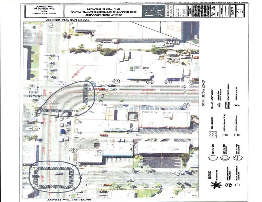
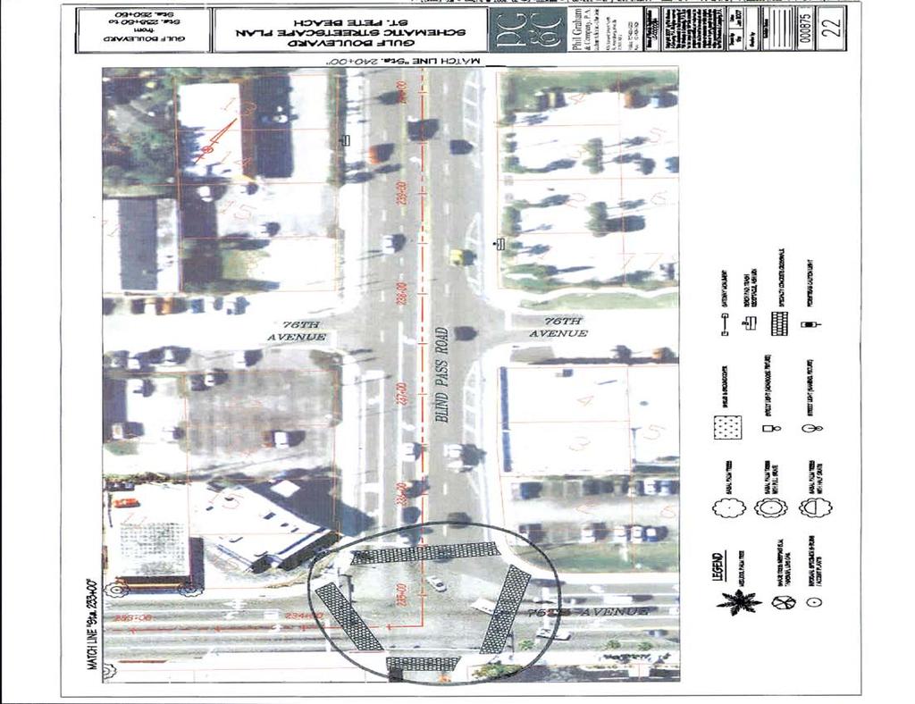
15 Pedestrian Safety Study - SR 699 (Blind Pass Rd/Gulf Blvd) from 93rd Avenue to Pinellas Bayway Five pedestrian and bicycle crashes were reported during the study period at this intersection. Consider installing a crosswalk and pedestrian features across the south side of the intersection. Consider installing high emphasis crosswalks at this intersection. SR 699 (Gulf Boulevard) from 44 th Avenue to Pinellas Bayway There is pedestrian activity concentrated in the area of the signals and Beach House Suites by the Don Cesar and Undertow Beach Bar. There are trolley/bus stops on both sides of Gulf Boulevard in front of Beach House Suites by the Don Cesar. No pedestrian or bicycle crashes were reported during the study period within this area. There are two existing landscaped median islands within this segment. Consider installing a median with pedestrian cut-through and crosswalk near the Beach House Suites by the Don Cesar and Undertow Beach Bar. The high concentration of pedestrians, the trolley/bus stops, and the driveway spacing make this area a good location for pedestrian facilities. Install pedestrian lighting and signing with high reflective paint on the median noses. See Appendix C for Conceptual Diagram. Consider the installation of raised medians with painted left turn lanes on either side of 3 th Avenue. There is a public beach access point at this location. The median could serve as a pedestrian refuge for any that may cross here to access the beach. SR 699 (Gulf Boulevard) at Pinellas Bayway (Signalized) This intersection has pedestrian countdown signals across the north, south and west sides of the intersection. There is a standard crosswalk across the north side of the intersection and a high emphasis crosswalk across the south side of the intersection. There is no crosswalk on the west side of the intersection. The pedestrian signal signs are not countdown. The pedestrian detector in the northeast corner is not ADA accessible. The pedestrian detector and sign in the northwest corner to cross the west approach is not ADA accessible, the detector is old and the sign is not legible. Pedestrian Crossing on North Approach The pedestrian detector and signal in the southwest corner to cross the west approach is too far from the crossing and is not ADA accessible. There is a No Right Turn on Red blank out sign that activates for westbound right turning vehicles when the pedestrian pushbutton is activated for crossing the north approach. The signal provides approximately seconds of Walk time and 23 seconds of flashing Don t Walk time to cross the north and south sides of the intersection. This is adequate time for a pedestrian to cross the approach. The signal provides approximately seconds of Walk time and 28 seconds of flashing Don t Walk time to cross the west side of the intersection. This is adequate time for a pedestrian to cross the approach. There is a concentration of pedestrian crossing activity at this intersection. Three pedestrian crashes were reported during the study period at this intersection. Consider installing high emphasis crosswalks at this intersection. Add a crosswalk across the west side of the intersection. Consider installing a raised island in the northeast corner of the intersection to serve as a refuge for pedestrians crossing the north side of the intersection. HNTB Corporation 12
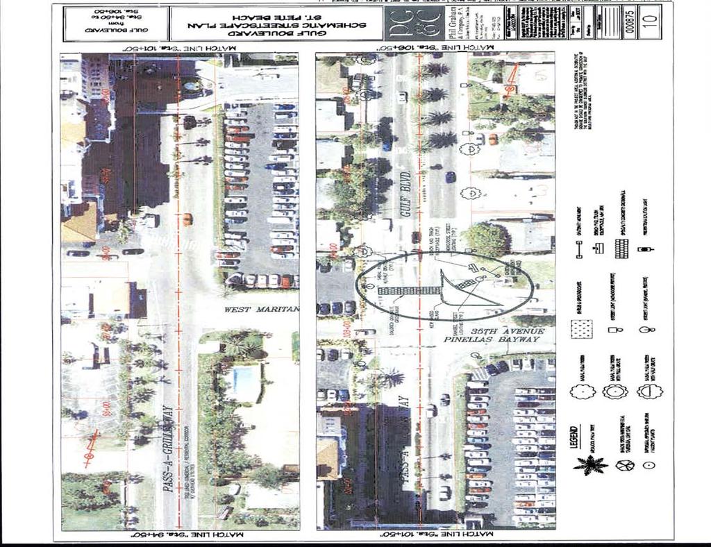
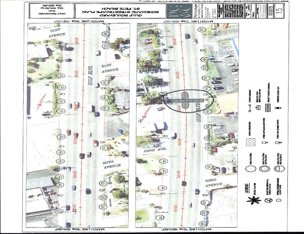
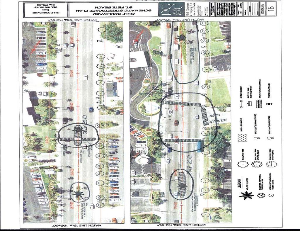
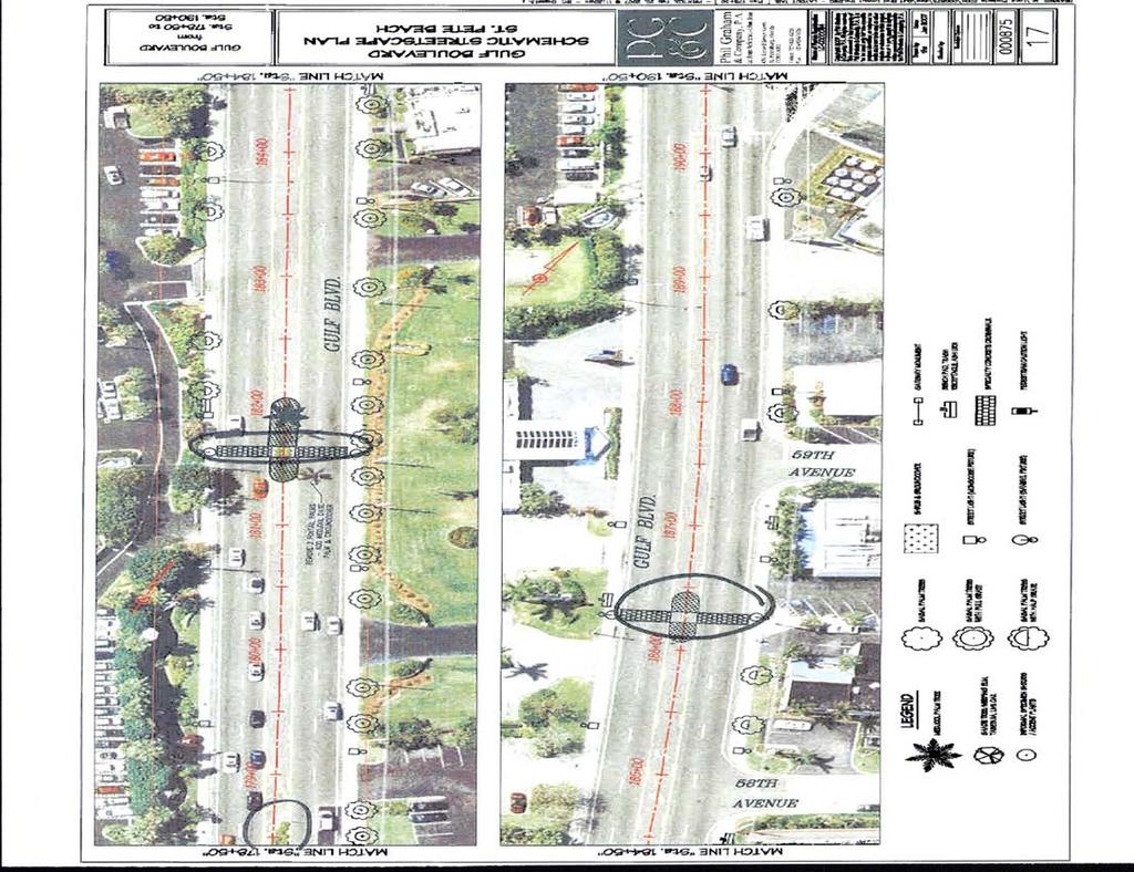
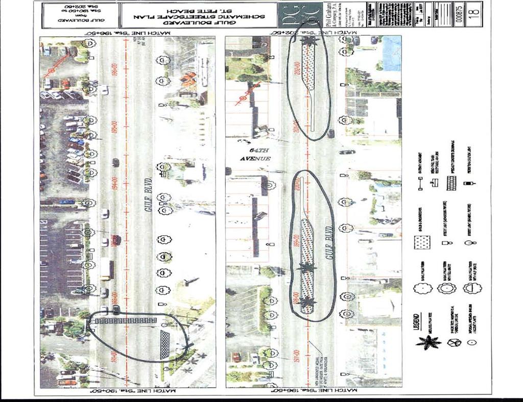
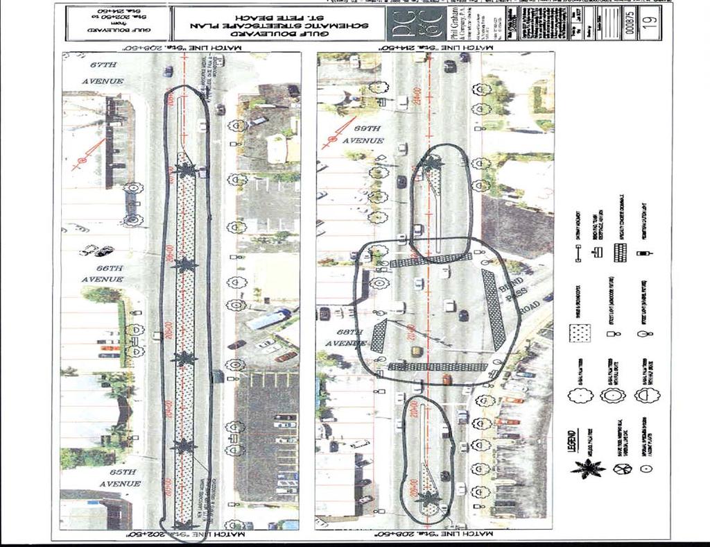
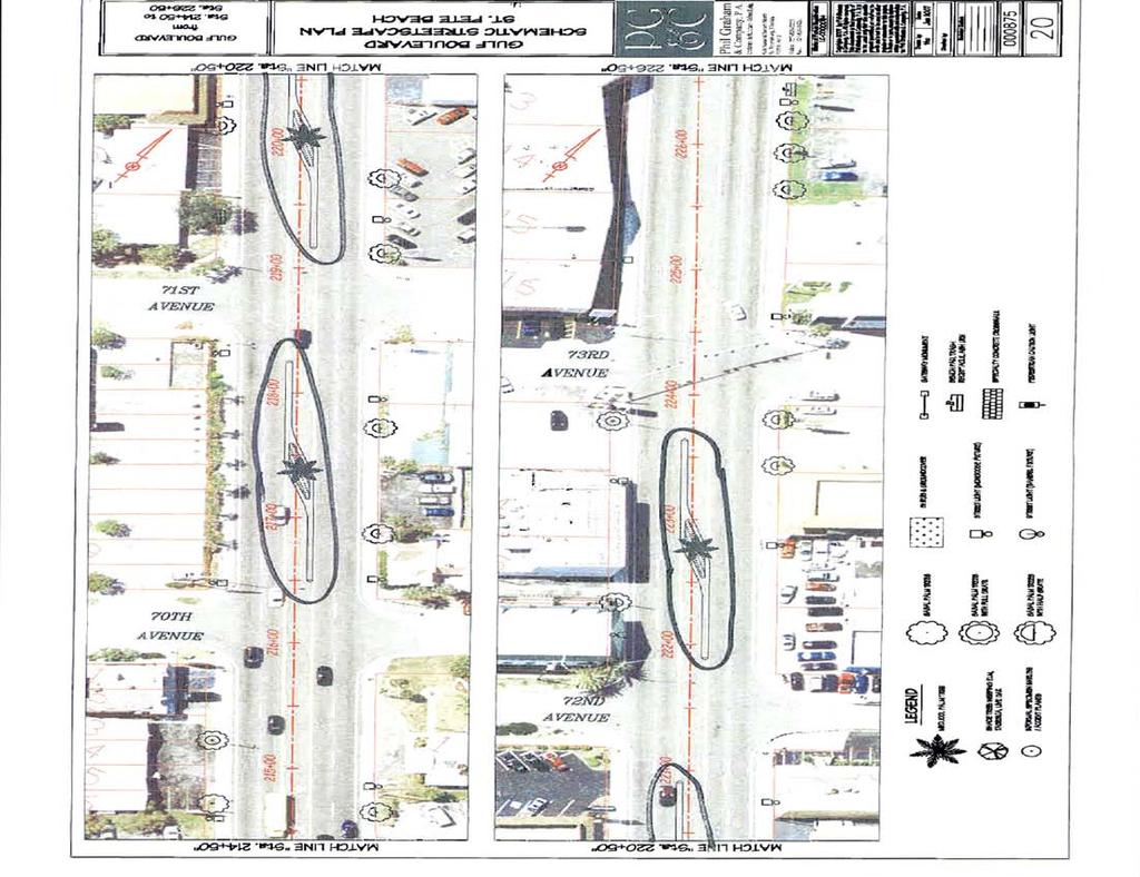
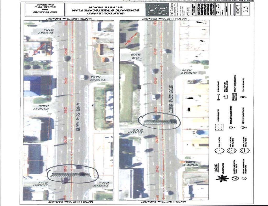
16 Pedestrian Safety Study - SR 699 (Blind Pass Rd/Gulf Blvd) from 93rd Avenue to Pinellas Bayway 6. RECOMMENDATIONS Based on the results of the data collection activities, qualitative assessment, collision analysis, field observations, and engineering judgment, the following recommendations were developed: 1. Install ADA compliant detectable truncated domes on the sidewalk ramps within the study area. 2. Remove the unused driveway curb cuts in the sidewalk along SR Repair the sidewalk and remove the tripping hazards in the sidewalk along both sides of SR 699 within the study limits. 4. Change pedestrian signal signs to countdown type (FTP 68B 06) for all approaches at the signalized intersections within the study limits. 5. Retime the pedestrian Don t Walk phases at the signalized intersections to give additional clearance time using the new MUTCD requirements. 6. Consider installing a raised concrete separator with a northbound left turn lane at 93 rd Avenue as shown in Appendix C, Sheet 1.. Consider installing a raised concrete separator with a northbound left turn lane at th Avenue as shown in Appendix C, Sheet Consider relocating the crosswalk, pedestrian signs, and flashers from north of th Avenue to south of th Avenue in front of Sweet Bay near the bus stop as shown in Appendix C, Sheet Install raised median islands on Gulf Boulevard from 3 rd Avenue to 69 th Avenue as shown in Appendix C, Sheet Install raised median islands on Gulf Boulevard from 6 th Avenue to 64 th Avenue as shown in Appendix C, Sheets 2 and Install a raised median with pedestrian cut-through and crosswalk on Gulf Boulevard on the north side of the -Eleven. Install pedestrian lighting, signing, and high reflective paint on the median noses. See Appendix C, Sheet 3 for Conceptual Diagram. 12. Install high emphasis crosswalks at all signalized locations. 13. Add a crosswalk and pedestrian signals across the south side and crosswalk striping across the west side of the intersection at Gulf Winds Drive. 14. Relocate the pedestrian detector in the northeast corner to cross 55 th Avenue to be located on the same pole as the pedestrian signal head. 15. Add a crosswalk and pedestrian signals across the west side of the intersection at 55 th Avenue. 16. Install crosswalks on the east and west approaches at St Pete Beach Access/Dolphin Village Entrance. 1. Install a crosswalk and pedestrian features across the south side of the intersection at 44 th Avenue. 18. Install a raised median with pedestrian cut-through and crosswalk near the Beach House Suites by the Don Cesar and Undertow Beach Bar. Install pedestrian lighting, signing, and high reflective paint on the median noses. See Appendix C for Conceptual Diagram. 19. Consider installing raised medians with painted left turn lanes on both sides of 3 th Avenue as shown in Appendix C, Sheet Relocate the pedestrian detectors in the northeast and southwest corners to be ADA accessible at Pinellas Bayway. 21. Replace and relocate the pedestrian detector and sign in the northwest corner to be ADA accessible at Pinellas Bayway. 22. Add a crosswalk across the west side of the intersection at Pinellas Bayway. 23. Install a raised island in the northeast corner of the intersection to serve as a refuge for pedestrians crossing the north side of the intersection at Pinellas Bayway. These improvements are illustrated in the Conceptual Drawings in Appendix C. HNTB Corporation 13
17 Pedestrian Safety Study - SR 699 (Blind Pass Rd/Gulf Blvd) from 93rd Avenue to Pinellas Bayway APPENDICES HNTB Corporation 14
18 Pedestrian Safety Study - SR 699 (Blind Pass Rd/Gulf Blvd) from 93rd Avenue to Pinellas Bayway APPENDI A PEDESTRIAN AND BICYCLE CROSSING DATA HNTB Corporation
19
20
21
22
23 Pedestrian Safety Study - SR 699 (Blind Pass Rd/Gulf Blvd) from 93rd Avenue to Pinellas Bayway APPENDI B PEDESTRIAN AND BICYCLE COLLISION DATA HNTB Corporation
24 FLORIDA DEPARTMENT OF TRANSPORTATION COLLISION SUMMARY Section: State Route: Gulf Boulevard (SR 699) Location: From Pinellas Bayway to 93rd Avenue M.P.: to Engineer: HNTB Study Period: 1/1/2002 TO 12/31/2002 County: Pinellas Prop. Day/ Wet/ Contributing No. Date Day Time Type Fatal Injury Damage Night Dry Cause 1 1/28/2002 Mon. 16:31 Collision w/ Ped x Day Dry 2 3/26/2002 Tue. 1:03 Collision w/ Bike x Day Dry 3 3/31/2002 Sun. 8:45 Collision w/ Bike x Day Dry 4 4/20/2002 Sat. 20:00 Collision w/ Bike x Night Dry 5 5/10/2002 Fri. 8:40 Collision w/ Ped x Day Dry 6 5/31/2002 Fri. 13:16 Collision w/ Ped x Day Dry 11/4/2002 Mon. 18:48 Collision w/ Ped x Night Dry 8 11/28/2002 Thu. :00 Collision w/ Bike x Day Dry 9 12/1/2002 Tue. 16:00 Collision w/ Bike x Day Dry Disregarded Traffic Control FTYRW Careless Driving Other Other Other Other Careless Driving Careless Driving Total Property Left Right Rear Side No. Fatal Injury Damage Angle Turn Turn End Swipe % One Ped/ Excessive Failure to Vehicle Bike Day Night Wet Dry Speed Yield R/W DUI
25 FLORIDA DEPARTMENT OF TRANSPORTATION COLLISION SUMMARY Section: State Route: Gulf Boulevard (SR 699) Location: From Pinellas Bayway to 93rd Avenue M.P.: to Engineer: HNTB Study Period: 1/1/2003 TO 12/31/2003 County: Pinellas Prop. Day/ Wet/ Contributing No. Date Day Time Type Fatal Injury Damage Night Dry Cause 1 1/15/2003 Wed. 15:15 Collision w/ Bike x Day Dry 2 3/5/2003 Wed. 19:1 Collision w/ Bike x Night Dry 3 3/20/2003 Thu. 15:18 Collision w/ Bike x Day Dry 4 3/21/2003 Fri. 23:10 Collision w/ Bike x Night Dry Careless Driving/DUI No Improper Driving Careless Driving DUI Total Property Left Right Rear Side No. Fatal Injury Damage Angle Turn Turn End Swipe % One Ped/ Excessive Failure to Vehicle Bike Day Night Wet Dry Speed Yield R/W DUI
26 FLORIDA DEPARTMENT OF TRANSPORTATION COLLISION SUMMARY Section: State Route: Gulf Boulevard (SR 699) Location: From Pinellas Bayway to 93rd Avenue M.P.: to Engineer: HNTB Study Period: 1/1/2004 TO 12/31/2004 County: Pinellas Prop. Day/ Wet/ Contributing No. Date Day Time Type Fatal Injury Damage Night Dry Cause 1 3/30/2004 Tue. 21:23 Collision w/ Ped x Night Dry 2 8/5/2004 Thu. 8:18 Collision w/ Bike x Day Wet 3 8/25/2004 Wed. 6:3 Collision w/ Bike x Night Dry 4 11/23/2004 Tue. 18:21 Collision w/ Ped x Night Dry FTYRW FTYRW DUI FTYRW Total Property Left Right Rear Side No. Fatal Injury Damage Angle Turn Turn End Swipe % One Ped/ Excessive Failure to Vehicle Bike Day Night Wet Dry Speed Yield R/W DUI
27 FLORIDA DEPARTMENT OF TRANSPORTATION COLLISION SUMMARY Section: State Route: Gulf Boulevard (SR 699) Location: From Pinellas Bayway to 93rd Avenue M.P.: to Engineer: HNTB Study Period: 1/1/2005 TO 12/31/2005 County: Pinellas Prop. Day/ Wet/ Contributing No. Date Day Time Type Fatal Injury Damage Night Dry Cause 1 1/19/2005 Wed. 16:2 Collision w/ Ped x Day Dry 2 2/19/2005 Sat. 20:16 Collision w/ Ped x Night Dry 3 4/1/2005 Sun. 23:05 Collision w/ Ped x Night Dry 4 5/22/2005 Tue. 18:44 Collision w/ Ped x Day Dry 5 6//2005 Thu. 12:05 Collision w/ Bike x Day Dry 6 //2005 Tue. :4 Collision w/ Ped x Day Dry /12/2005 Fri. 10:15 Collision w/ Ped x Day Dry 8 /29/2005 Wed. 0:15 Collision w/ Ped x Night Dry 9 10/19/2005 Sun. 8:00 Collision w/ Bike x Day Dry 10 11/6/2005 Sat. 9:09 Collision w/ Ped x Day Dry FTYRW Other FTYRW Other FTYRW FTYRW Other DUI Driving Wrong Side/Way FTYRW Total Property Left Right Rear Side No. Fatal Injury Damage Angle Turn Turn End Swipe % One Ped/ Excessive Failure to Vehicle Bike Day Night Wet Dry Speed Yield R/W DUI
28 FLORIDA DEPARTMENT OF TRANSPORTATION COLLISION SUMMARY Section: State Route: Gulf Boulevard (SR 699) Location: From Pinellas Bayway to 93rd Avenue M.P.: to Engineer: HNTB Study Period: 1/1/2006 TO 12/31/2006 County: Pinellas Prop. Day/ Wet/ Contributing No. Date Day Time Type Fatal Injury Damage Night Dry Cause 1 4/26/2006 Wed. 18:23 Collision w/ Ped x Day Dry 2 5/26/2006 Fri. 11:52 Collision w/ Ped x Day Dry 3 /4/2006 Tue. 14:24 Collision w/ Ped x Day Dry 4 10/21/2006 Sat. 9:45 Collision w/ Ped x Day Dry 5 11/6/2006 Mon. 9:09 Collision w/ Ped x Day Dry 6 11/22/2006 Wed. 1:53 Collision w/ Ped x Night Dry 12/31/2006 Sun. 18:38 Collision w/ Ped x Night Dry Other/Alcohol Involved Disregarded Traffic Signal Careless Driving Careless Driving FTYRW Careless Driving/DUI Careless Driving Total Property Left Right Rear Side No. Fatal Injury Damage Angle Turn Turn End Swipe % One Ped/ Excessive Failure to Vehicle Bike Day Night Wet Dry Speed Yield R/W DUI
29 FLORIDA DEPARTMENT OF TRANSPORTATION COLLISION SUMMARY Section: State Route: Gulf Boulevard (SR 699) Location: From Pinellas Bayway to 93rd Avenue M.P.: to Engineer: HNTB Study Period: 1/1/200 TO 12/31/200 County: Pinellas Prop. Day/ Wet/ Contributing No. Date Day Time Type Fatal Injury Damage Night Dry Cause 1 2/8/200 Thu. 8:49 Collision w/ Ped x Day Dry 2 2/20/200 Tue. 9:30 Collision w/ Ped x Day Dry 3 3/24/200 Sat. 20:40 Collision w/ Ped x Night Dry 4 4/10/200 Tue. 10:34 Collision w/ Ped x Day Wet 5 4/29/200 Sun. 14:39 Collision w/ Bike x Day Dry 6 6/14/200 Thu. 22:03 Collision w/ Bike x Night Dry 10/19/200 Fri. 20:08 Collision w/ Ped x Night Dry 8 11/29/200 Thu. 15:23 Bicycle Hit Ped x Day Dry FTYRW Other No Improper Driving FTYRW Careless Driving Improper Lane Change Alcohol - Under Influence Careless Driving Total Property Left Right Rear Side No. Fatal Injury Damage Angle Turn Turn End Swipe % One Ped/ Excessive Failure to Vehicle Bike Day Night Wet Dry Speed Yield R/W DUI
30
31
32
33
34 Pedestrian Safety Study - SR 699 (Blind Pass Rd/Gulf Blvd) from 93rd Avenue to Pinellas Bayway APPENDI C CONCEPTUAL IMPROVEMENT PLAN HNTB Corporation
35
36
37
38
39
40 Pedestrian Safety Study - SR 699 (Blind Pass Rd/Gulf Blvd) from 93rd Avenue to Pinellas Bayway APPENDI D EISTING SIGNAL TIMINGS HNTB Corporation
41 SIGNAL TIMING SHEET Pinellas County Traffic Engineering Signal No : 93 Location : 5TH AVENUE N. & BLIND PASS ROAD Jurisdiction : STATE/ST PETE BEACH Section # Address# 45 2 Controller Make Model Type Operation PEEK 3000 E 8 PHASE 6 PHASE/SEMI Ph1 5TH AVE EB LT R Ph5 5TH AVE. WB LT R Ph2 5TH AVE WB Ph6 5TH AVE EB Ph3 Ph Ph4 BLIND PASS RD NB LAG R Ph8 BLIND PASS RD. SB LEAD R Timing & Phasing Phase Min. Green Extension Yellow CL Red CL Max Max 2 Max 3 Walk FDW Min Recall Max Recall Ped Recall Non Lock CNA1 CNA2 Phase Omit Ped Omit Flash Y R Y R Delay Det. Dipswitches TBC PREEMPT ON Additional Sheets => YES NO Comments SEE SEPARATE PROGRAMMING SHEET Last Timing Change: 11/29/2006 Database Revised 12/04/2006 Control Center Use Only
42 SIGNAL TIMING SHEET Pinellas County Traffic Engineering Signal No : 94 Location : 5TH ST & GULF BLVD Jurisdiction : STATE/ST PETE BEACH Section # Address# 45 3 Controller Make Model Type Operation TRANSYT PHASE 5 PHASE/FULL Ph1 GULF BLVD. NB Ph5 5TH AVE. EB Ph2 5TH ST. WB Ph6 Ph3 GULF BLVD. SB LT P/P Ph Ph4 GULF BLVD. SB Ph8 Timing & Phasing Phase Min. Green 10 Extension Yellow CL Red CL Max Max 2 Max 3 Walk FDW Min Recall Max Recall Ped Recall Non Lock CNA1 CNA2 Phase Omit Ped Omit Flash R R R R Delay Det. Dipswitches TBC PREEMPT ON Additional Sheets => YES NO Comments OLA=1&2 (NBRT) OLB=3&4 (SB THRU) PED OL 2-2, 3-3, 4-3 & 4, 5-5 Last Timing Change: 01/30/200 Database Revised 02/02/200 Control Center Use Only
43 SIGNAL TIMING SHEET Pinellas County Traffic Engineering Signal No : 9 Location : GULF BLVD & COREY AVE Jurisdiction : STATE/ST PETE BEACH Section # Address# 45 6 Controller Make Model Type Operation TRANSYT 1880 EL 8 PHASE 4 PHASE/SEMI Ph1 Ph5 Ph2 GULF BLVD. SB Ph6 GULF BLVD. NB Ph3 Ph Ph4 COREY AVE. WB Ph8 COREY AVE. EB Timing & Phasing Phase Min. Green Extension Yellow CL Red CL Max Max 2 Max 3 Walk FDW Min Recall Max Recall Ped Recall Non Lock CNA1 CNA2 Phase Omit Ped Omit Flash Y R Y R Delay Det. Dipswitches TBC PREEMPT ON Additional Sheets => YES YES Comments PREEMPT ACTIVATED BY FIRE STATION AND IN CONJUNCTION WITH SIGNAL AT GULF & 3RD. Last Timing Change: 12/0/2000 Database Revised 02/18/2003 Control Center Use Only
44 SIGNAL TIMING SHEET Pinellas County Traffic Engineering Signal No : 980 Location : GULF BLVD & BLIND PASS Jurisdiction : STATE/ST PETE BEACH Section # Address# 46 Controller Make Model Type Operation TRANSYT 1880 EL 8 PHASE 4 PHASE/FULL Ph1 Ph5 Ph2 GULF BLVD. SB Ph6 GULF BLVD. NB Ph3 68TH AVENUE EB LEAD Ph Ph4 BLIND PASS WB LAG Ph8 Timing & Phasing Phase Min. Green Extension Yellow CL Red CL Max Max 2 Max 3 Walk FDW Min Recall Max Recall Ped Recall Non Lock CNA1 CNA2 Phase Omit Ped Omit Flash Y R R Y Delay Det. Dipswitches TBC PREEMPT ON Additional Sheets => YES NO Comments Last Timing Change: 12/0/2000 Database Revised 0/29/2003 Control Center Use Only
45 SIGNAL TIMING SHEET Pinellas County Traffic Engineering Signal No : 982 Location : GULF BLVD & GULF WINDS Jurisdiction : STATE/ST PETE BEACH Section # Address# 46 9 Controller Make Model Type Operation TRANSYT 1880 EL 8 PHASE 4 PHASE/FULL Ph1 Ph5 Ph2 GULF BLVD. SB Ph6 GULF BLVD. NB Ph3 RESORT EIT EB LEAD Ph Ph4 GULF WINDS WB LAG Ph8 Timing & Phasing Phase Min. Green Extension Yellow CL Red CL Max Max 2 Max 3 Walk FDW Min Recall Max Recall Ped Recall Non Lock CNA1 CNA2 Phase Omit Ped Omit Flash Y R R Y Delay Det. 4 Dipswitches TBC PREEMPT ON Additional Sheets => YES NO Comments Last Timing Change: 10/29/2003 Database Revised 10/29/2003 Control Center Use Only
46 SIGNAL TIMING SHEET Pinellas County Traffic Engineering Signal No : 983 Location : GULF BLVD & 55TH AVE./TRADEWINDS Jurisdiction : STATE/ST PETE BEACH Section # Address# 46 8 Controller Make Model Type Operation TRANSYT 1880 EL 8 PHASE 5 PHASE/SEMI Ph1 GULF BLVD. NB LT P/P Ph5 GULF BLVD. SB LT P/P Ph2 GULF BLVD. SB Ph6 GULF BLVD. NB Ph3 Ph Ph4 55TH AVE/TRADEWINDS RES EB/WB Ph8 Timing & Phasing Phase Min. Green Extension Yellow CL Red CL Max Max 2 Max 3 Walk FDW Min Recall Max Recall Ped Recall Non Lock CNA1 CNA2 Phase Omit Ped Omit Flash Y R Y Delay Det. Dipswitches TBC PREEMPT ON Additional Sheets => YES NO Comments FLASHES , DAY PROGRAM PHASE 2 PED TIMES FOR CNA PROGRAM ONLY Last Timing Change: 02/18/2003 Database Revised 01/16/200 Control Center Use Only
47 SIGNAL TIMING SHEET Pinellas County Traffic Engineering Signal No : 985 Location : GULF BLVD & DOLPHIN VILLAGE Jurisdiction : STATE/ST PETE BEACH Section # Address# Controller Make Model Type Operation TRANSYT 1880 EL 8 PHASE 6 PHASE/SEMI Ph1 GULF BLVD. NB LT P/P Ph5 GULF BLVD. SB LT P/P Ph2 GULF BLVD. SB Ph6 GULF BLVD. NB Ph3 Ph Ph4 DOLPHIN VILLAGE WB Ph8 PARK ENTRANCE EB Timing & Phasing Phase Min. Green Extension Yellow CL Red CL Max Max 2 Max 3 Walk FDW Min Recall Max Recall Ped Recall Non Lock CNA1 CNA2 Phase Omit Ped Omit Flash Y R Y R Delay Det. Dipswitches TBC PREEMPT ON Additional Sheets => YES NO Comments FLASH , DAYS Last Timing Change: 12/0/2000 Database Revised 08/15/2001 Control Center Use Only
48 SIGNAL TIMING SHEET Pinellas County Traffic Engineering Signal No : 986 Location : GULF BLVD & 44TH AVE Jurisdiction : STATE/ST PETE BEACH Section # Address# Controller Make Model Type Operation TRANSYT 1880 EL 8 PHASE 5 PHASE/SEMI Ph1 Ph5 GULF BLVD. SB LT P/P Ph2 GULF BLVD. SB Ph6 GULF BLVD. NB Ph3 Ph Ph4 44TH AVE. WB Ph8 44TH AVE. EB Timing & Phasing Phase Min. Green Extension Yellow CL Red CL Max Max 2 Max 3 Walk FDW Min Recall Max Recall Ped Recall Non Lock CNA1 CNA2 Phase Omit Ped Omit Flash Y R Y R Delay Det. Dipswitches TBC PREEMPT ON Additional Sheets => YES NO Comments FLASH , DAYS Last Timing Change: 12/0/2000 Database Revised 08/15/2001 Control Center Use Only
49 SIGNAL TIMING SHEET Pinellas County Traffic Engineering Signal No : 990 Location : GULF BLVD & PINELLAS BAYWAY Jurisdiction : STATE/ST PETE BEACH Section # Address# ISO Controller Make Model Type Operation TRANSYT 1880 EL 8 PHASE 4 PHASE/SEMI Ph1 GULF BLVD. SB LT R Ph5 Ph2 GULF BLVD NB & OLB NB/SB Ph6 Ph3 Ph Ph4 P4 PEDS & OLD Ph8 OLC (WB RT) & OLD Timing & Phasing Phase Min. Green Extension Yellow CL Red CL Max Max 2 Max 3 Walk FDW Min Recall Max Recall Ped Recall Non Lock CNA1 CNA2 Phase Omit Ped Omit Flash R R R Delay Det. Dipswitches TBC PREEMPT ON Additional Sheets => NO NO Comments OLB=SB,1,2,/ FL-Y, OLC=WB/RT 1,2,8/ FL-R OLD=EB/WB 4,8 PHASE 4 ACTIVATED BY PUSH BUTTON ONLY. PHASE 4 OMITS PHASE 8 Last Timing Change: 0/31/2003 Database Revised 0/31/2003 Control Center Use Only
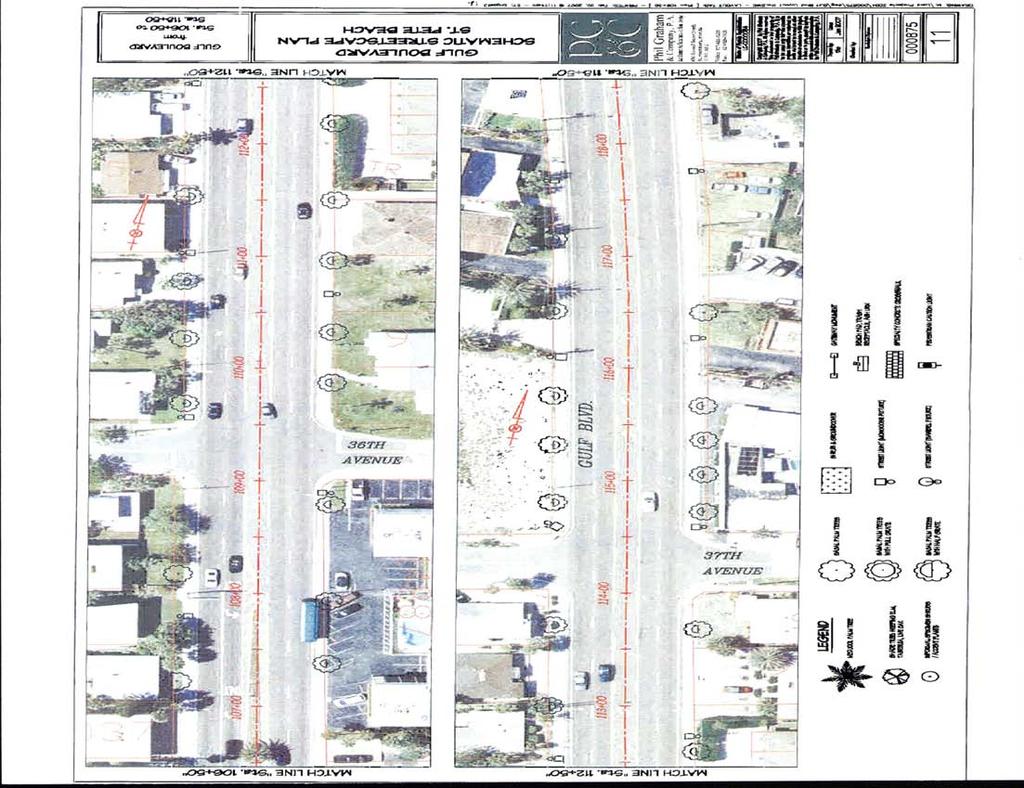
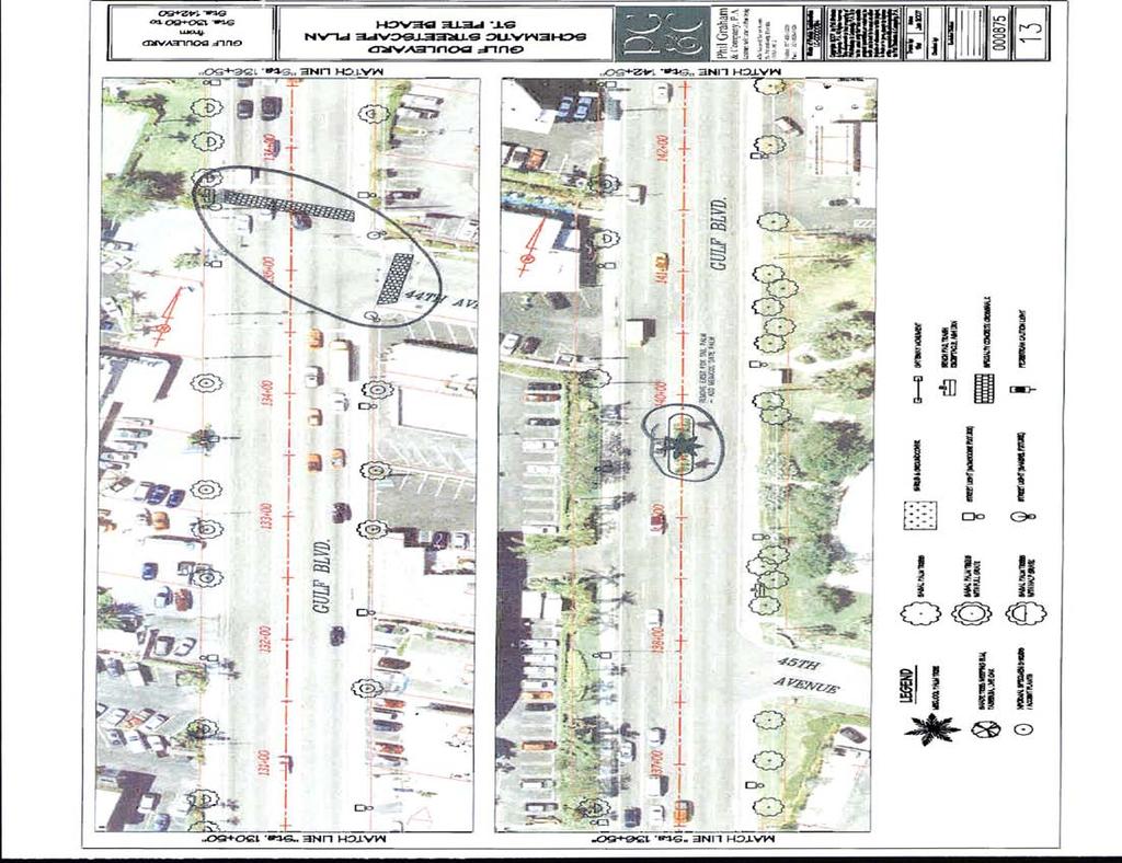
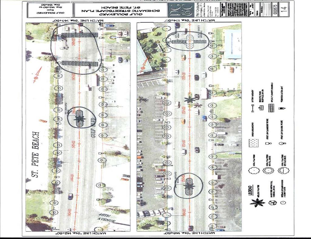
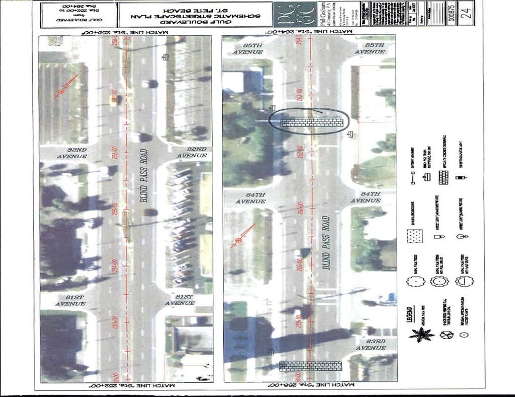
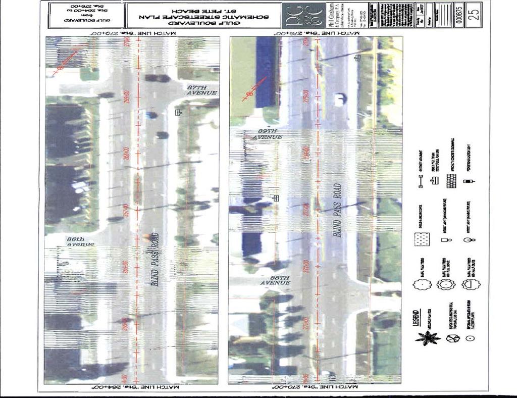
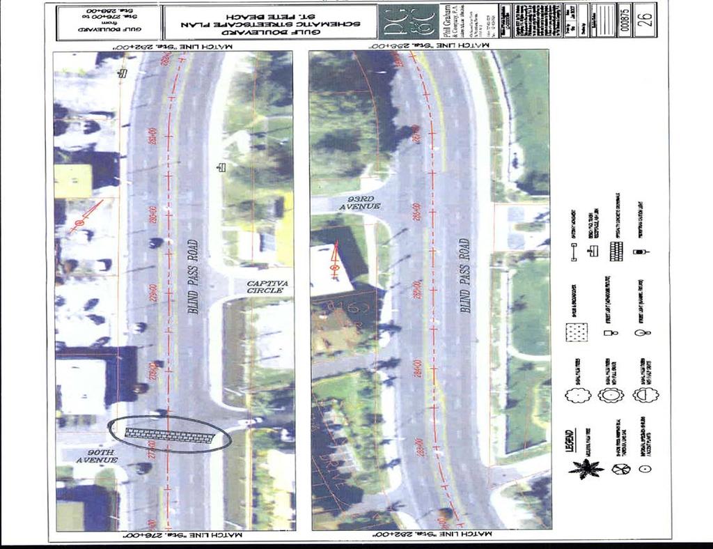
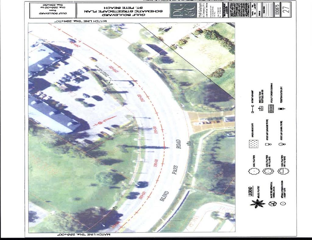
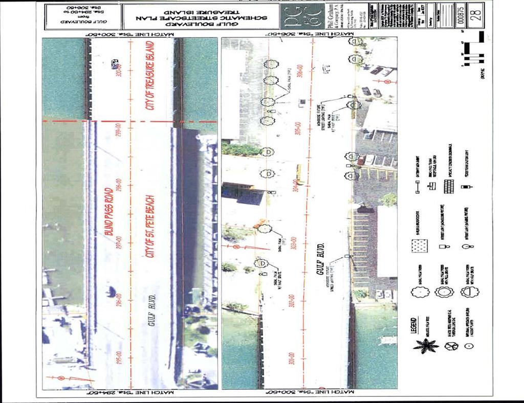
50 Pedestrian Safety Study - SR 699 (Blind Pass Rd/Gulf Blvd) from 93rd Avenue to Pinellas Bayway APPENDI E SCHEMATIC STREETSCAPE PLAN HNTB Corporation
51
52

53
54
55
56
57
58
59
60
61
62
63
64
65
66
67
68
69
Meadow Woods Elementary School
 Drag and drop pic and stretch/crop to the limits of the blue rectangle (delete this text box) Meadow Woods Elementary School Drag and drop pic and stretch/crop to the limits of the blue rectangle (delete
FLORIDA DEPARTMENT OF TRANSPORTATION DISTRICT 7 DISTRICT WIDE BICYCLE/PEDESTRIAN ACCESS TO TRANSIT SAFETY ASSESSMENT AND IMPROVEMENT PLAN
 FLORIDA DEPARTMENT OF TRANSPORTATION DISTRICT 7 DISTRICT WIDE BICYCLE/PEDESTRIAN ACCESS TO TRANSIT SAFETY ASSESSMENT AND IMPROVEMENT PLAN TRANSIT SAFETY ASSESSMENT SR 55/US 19 AT 80 TH AVE N DRAFT JUNE
Orange Center Elementary School
 Drag and drop pic and stretch/crop to the limits of the blue rectangle (delete this text box) Orange Center Elementary School Drag and drop pic and stretch/crop to the limits of the blue rectangle (delete
Hidden Oaks Elementary School
 Hidden Oaks Elementary School SCHOOL ROUTE PLAN For HIDDEN OAKS ELEMENTARY SCHOOL LOCATION 13 ORANGE COUNTY Prepared for: ORANGE COUNTY SCHOOL ASSESSMENT PROGRAM ORANGE COUNTY PUBLIC WORKS Traffic Engineering
Drag and drop pic and stretch/crop to the limits of the blue rectangle (delete this text box) Maxey Elementary School
 Maxey Elementary School") Drag and drop pic and stretch/crop to the limits of the blue rectangle (delete this text box) Maxey Elementary School SCHOOL ROUTE PLAN For MAXEY ELEMENTARY SCHOOL LOCATION 33 ORANGE COUNTY Prepared for:
Drag and drop pic and stretch/crop to the limits of the blue rectangle (delete this text box) Maxey Elementary School SCHOOL ROUTE PLAN For MAXEY ELEMENTARY SCHOOL LOCATION 33 ORANGE COUNTY Prepared for:
Lake Whitney Elementary School
 Lake Whitney Elementary School SCHOOL ROUTE PLAN For LAKE WHITNEY ELEMENTARY SCHOOL LOCATION 18 ORANGE COUNTY Prepared for: ORANGE COUNTY SCHOOL ASSESSMENT PROGRAM ORANGE COUNTY PUBLIC WORKS Traffic Engineering
Military Road Safety Improvements
 Military Road Safety Improvements 26 th Road North to 31 st Street North SUMMARY OF DATA REVIEW AND PRELIMINARY RECOMMENDATIONS Prepared for: Department of Environmental Services Traffic Engineering and
Durrance Elementary School
 Durrance Elementary School SCHOOL ROUTE PLAN For DURRANCE ELEMENTARY SCHOOL LOCATION 9 ORANGE COUNTY Prepared for: ORANGE COUNTY SCHOOL ASSESSMENT PROGRAM ORANGE COUNTY PUBLIC WORKS Traffic Engineering
TRAFFIC CONTROL DEVICES ON EDGEWATER BOULEVARD AT PORT ROYAL AVENUE (NORTH)
") Attachment 2 DATE: August 6, 2012 TO: VIA: FROM: SUBJECT: Mayor and Members of the City Council James C. Hardy, City Manager Ramon Towne, Director of Public Works Leah Edwards, Assistant Engineer TRAFFIC
Attachment 2 DATE: August 6, 2012 TO: VIA: FROM: SUBJECT: Mayor and Members of the City Council James C. Hardy, City Manager Ramon Towne, Director of Public Works Leah Edwards, Assistant Engineer TRAFFIC
SCHOOL ROUTE PLAN. For HUNTER S CREEK ELEMENTARY SCHOOL LOCATION 14 ORANGE COUNTY. Prepared for:
 SCHOOL ROUTE PLAN For HUNTER S CREEK ELEMENTARY SCHOOL LOCATION 14 ORANGE COUNTY Prepared for: ORANGE COUNTY SCHOOL ASSESSMENT PROGRAM ORANGE COUNTY PUBLIC WORKS Traffic Engineering Division 42 South John
MEMORANDUM. DATE March 1, 2012 TO Town of Milton Mark Abbott, Seth Asante, and Efi Pagitsas Boston Region MPO Staff
 MEMORANDUM DATE March 1, 212 TO Town of Milton FROM RE Mark Abbott, Seth Asante, and Efi Pagitsas Boston Region MPO Staff FFY 211 Safety and Operations Analyses at Selected Boston Region MPO Intersections:
Route 28 (South Orleans Road)/Route 39 (Harwich Road)/Quanset Road Intersection
/Route 39 (Harwich Road)/Quanset Road Intersection") TRAFFIC FEASIBILITY STUDY Route 28 (South Orleans Road)/Route 39 (Harwich Road)/Quanset Road Intersection Orleans, Massachusetts Prepared for: Town of Orleans Prepared by: Fay, Spofford & Thorndike, LLC
TRAFFIC FEASIBILITY STUDY Route 28 (South Orleans Road)/Route 39 (Harwich Road)/Quanset Road Intersection Orleans, Massachusetts Prepared for: Town of Orleans Prepared by: Fay, Spofford & Thorndike, LLC
SR/CR A1A PEDESTRIAN SAFETY & MOBILITY STUDY
 SR/CR AA PEDESTRIAN SAFETY & MOBILITY STUDY PEDESTRIAN / BICYCLE SAFETY REVIEW Focus Area H / 9th Street S to 3th Street N Prepared for: River to Sea Transportation Planning Organization 2570 West International
Windy Ridge Elementary School
 Windy Ridge Elementary School SCHOOL ROUTE PLAN For WINDY RIDGE ELEMENTARY SCHOOL LOCATION 54 ORANGE COUNTY Prepared for: ORANGE COUNTY SCHOOL ASSESSMENT PROGRAM ORANGE COUNTY PUBLIC WORKS Traffic Engineering
SR 907 (Alton Road) between Barry Street and 41 st Street
 between Barry Street and 41 st Street") TWO 20 Pedestrian Safety Study SR 907 (Alton Road) between Barry Street and 41 st Street Miami Beach, Miami-Dade County DRAFT Florida Department of Transportation District VI June 2014 TWO 20 Pedestrian
TWO 20 Pedestrian Safety Study SR 907 (Alton Road) between Barry Street and 41 st Street Miami Beach, Miami-Dade County DRAFT Florida Department of Transportation District VI June 2014 TWO 20 Pedestrian
Road Diets FDOT Process
 Florida Department of TRANSPORTATION Road Diets FDOT Process Humberto Castillero, PE, PTOE Roadway Design Office Purpose of Guide Develop a statewide lane elimination review process Balance state & local
Date: April 4, Project #: Re: A Street/Binford Street Traffic/Intersection Assessment
 To: Peter Cavanaugh General Electric From: David Bohn, PE Ryan White, PE Date: April 4, 217 Project #: 13421. Re: / Traffic/Intersection Assessment Consistent with the Cooperation Agreement between the
FINAL DESIGN TRAFFIC TECHNICAL MEMORANDUM
 FINAL DESIGN TRAFFIC TECHNICAL MEMORANDUM July 2014 FINAL (SR 43) Project Development and Environment Study From State Road 60 (Adamo Drive) to I-4 (SR 400) Hillsborough County, Florida Work Program Item
PEDESTRIAN / BICYCLE SAFETY REVIEW
 PEDESTRIAN / BICYCLE SAFETY REVIEW SR 50 / Clearlake Road from Dixon Boulevard to Michigan Avenue Prepared for: Space Coast Transportation Planning Organization 2725 Judge Fran Jamieson Way Bldg. B / Room
Multi-Modal Traffic Analysis. Parisi and Associates
 Mill Valley to Corte Madera Bicycle and Pedestrian Corridor Study Appendix D: Multi-Modal Traffic Analysis Prepared by Parisi and Associates August 2009 Appendix D - Multi-Modal Traffic Analysis Table
STILLWATER AVENUE CORRIDOR STUDY Old Town, Maine
 Draft Study STILLWATER AVENUE CORRIDOR STUDY Old Town, Maine SUBMITTED TO: BANGOR AREA COMPREHENSIVE TRANSPORTATION SYSTEM SUBMITTED BY: I MAY 23, 2017 DRAFT STILLWATER AVENUE STUDY FINAL REPORT Table
ALLEY 24 TRAFFIC STUDY
 ALLEY 24 TRAFFIC STUDY in City of Frostburg, Maryland January 2013 3566 Teays Valley Road Hurricane, WV Office: (304) 397-5508 www.denniscorporation.com Alley 24 Traffic Study January 2013 Frostburg, Maryland
Traffic Impact Analysis Chatham County Grocery Chatham County, NC
 Chatham County Grocery Chatham County, NC TABLE OF CONTENTS 1. INTRODUCTION... 1 1.1. Location and Study Area... 1 1.2. Proposed Land Use and Access... 2 1.3. Adjacent Land Uses... 2 1.4. Existing ways...
PEDESTRIAN / BICYCLE SAFETY REVIEW
 PEDESTRIAN / BICYCLE SAFETY REVIEW Palm Bay Road from Babcock Street to Lipscomb Street Prepared for: Space Coast Transportation Planning Organization 2725 Judge Fran Jamieson Way Bldg. B / Room 05 / MS
District 4 Road Safety Audit Report
 District 4 Road Safety Audit Report SR-704 (Okeechobee Boulevard) AT Florida Avenue / Rosemary Avenue Section: 93 280 000 Mile Post: 8.881 Section: 93 280 001 Mile Post: 0.522 Task Work Order No. 19 Contract
DEPARTMENT OF ENVIRONMENTAL SERVICES. North Harrison Street (Lee Highway to Little Falls Road) Comparative Analysis. Prepared for:
 Comparative Analysis. Prepared for:") DEPARTMENT OF ENVIRONMENTAL SERVICES North Harrison Street (Lee Highway to Little Falls Road) Comparative Analysis Prepared for: Arlington County Department of Environmental Services 2100 Clarendon Boulevard,
DEPARTMENT OF ENVIRONMENTAL SERVICES North Harrison Street (Lee Highway to Little Falls Road) Comparative Analysis Prepared for: Arlington County Department of Environmental Services 2100 Clarendon Boulevard,
INDUSTRIAL BUILDING 3009 HAWTHORNE ROAD CITY OF OTTAWA TRANSPORTATION OVERVIEW REVISED. Prepared for: Canada Inc.
 INDUSTRIAL BUILDING 3009 HAWTHORNE ROAD CITY OF OTTAWA TRANSPORTATION OVERVIEW REVISED Prepared for: 7849648 Canada Inc. Octiober 1, 2015 114-598 Overview_2.doc D. J. Halpenny & Associates Ltd. Consulting
Traffic Impact Study WestBranch Residential Development Davidson, NC March 2016
 Traffic Impact Study WestBranch Residential Development Davidson, NC March 216 TRAFFIC IMPACT STUDY FOR THE WestBranch Residential Development LOCATED IN DAVIDSON, NC Prepared For: Lennar Carolinas, LLC
APPENDIX A: Complete Streets Checklist DRAFT NOVEMBER 2016
 APPENDIX A: Complete Streets Checklist DRAFT NOVEMBER 2016 Complete Streets Checklist MetroPlan Orlando s Complete Streets Checklist is an internal planning tool for staff to further implementation of
Traffic Impact Analysis Walton Acres at Riverwood Athletic Club Clayton, NC
 Traffic Impact Analysis Walton Acres at Riverwood Athletic Club Clayton, NC 1. TABLE OF CONTENTS INTRODUCTION...1 1.1. Site Location and Study Area...1 1.2. Proposed Land Use and Site Access...2 1.3.
TRAFFIC ACTION PLAN. Central Neighborhood CITY OF SAN MATEO
 TRAFFIC ACTION PLAN Central Neighborhood CITY OF SAN MATEO Draft January 2017 Table of Contents Introduction... 1 The Traffic Forum Process... 4 Neighborhood Traffic Issues... 7 Neighborhood Recommendations
1609 E. FRANKLIN STREET HOTEL TRAFFIC IMPACT STUDY EXECUTIVE SUMMARY
 1609 E. FRANKLIN STREET HOTEL TRAFFIC IMPACT STUDY EXECUTIVE SUMMARY Prepared for: The Town of Chapel Hill Public Works Department Traffic Engineering Division Prepared by: HNTB North Carolina, PC 343
Poor pavement condition Substandard Intersections. / Substandard bike/pedestrian/transit accommodations. Driveway access Environmental concerns
 Public Informational Meeting University Avenue (Allen Boulevard Segoe Road) March 23, 2011 City of Madison City of Middleton Village of Shorewood Hills Dane County Existing Roadway Conditions Poor pavement
Fundamentals of Traffic Control Devices
 Fundamentals of Traffic Control Devices Traffic Engineering & Operations October 8, 2014 Raj Ponnaluri, Angela Wilhelm, and Christopher Lewis Agenda Agenda Signs Pavement Markings Signals Traffic Operations
IMPLEMENTATION WORKBOOK
 Lawrence Township Bicycle and Pedestrian Planning Assistance Study IMPLEMENTATION WORKBOOK Final Action Plan - Part 2 April 2009 Prepared For: The Township of Lawrence and the New Jersey Department of
Retrofitting Urban Arterials into Complete Streets
 Retrofitting Urban Arterials into Complete Streets John N. LaPlante, P.E., P.T.O.E., T.Y. Lin International Prepared for: Illinois Traffic Engineering & Safety Conference Urbana, Illinois October 18, 2007
TRAFFIC SIGNAL WARRANT STUDY
 TRAFFIC SIGNAL WARRANT STUDY 5 th STREET & ENCHANTED PINES DRIVE JANUARY 2013 TRAFFIC OPERATIONS ENGINEERING SERVICES/PUBLIC WORKS DEPARTMENT TABLE OF CONTENTS INTERSECTION LOCATION MAP ii INTRODUCTION
MEMORANDUM. Layout Of Study Intersections And Traffic Control
 BOSTON REGION METROPOLITAN PLANNING ORGANIZATION Richard A. Davey, MassDOT Secretary and CEO and MPO Chairman Karl H. Quackenbush, Executive Director, MPO Staff DATE November 15, 2012 TO FROM RE Town of
AGENDA ITEM 6 D THOMASVILLE ROAD (HERMITAGE BOULEVARD TO LIVE OAK PLANTATION ROAD) ROADWAY SAFETY AUDIT
 ROADWAY SAFETY AUDIT") May 15, 2018 AGENDA ITEM 6 D THOMASVILLE ROAD (HERMITAGE BOULEVARD TO LIVE OAK PLANTATION ROAD) ROADWAY SAFETY AUDIT TYPE OF ITEM: Discussion STATEMENT OF ISSUE The Florida Department of Transportation
May 15, 2018 AGENDA ITEM 6 D THOMASVILLE ROAD (HERMITAGE BOULEVARD TO LIVE OAK PLANTATION ROAD) ROADWAY SAFETY AUDIT TYPE OF ITEM: Discussion STATEMENT OF ISSUE The Florida Department of Transportation
Broadway Street Pedestrian Safety Study Cass Street to 700 Feet North of Randall Avenue
 Broadway Street Pedestrian Safety Study Cass Street to 700 Feet North of Randall Avenue Prepared for: City of De Pere, Wisconsin Prepared by: June, 2017 Broadway Street Pedestrian Safety Study Cass Street
Small Area Study U.S. Route 220 and VA Route 615 Intersection. Bath County, Virginia
 Small Area Study U.S. Route 220 and VA Route 615 Intersection Bath County, Virginia Prepared by the Central Shenandoah Planning District Commission Final Report February 2018 Table of Contents 1. INTRODUCTION...
TRAFFIC ACTION PLAN. Laurie Meadows Neighborhood CITY OF SAN MATEO
 TRAFFIC ACTION PLAN Laurie Meadows Neighborhood CITY OF SAN MATEO Draft January 2017 Table of Contents Introduction... 2 The Traffic Forum Process... 5 Neighborhood Traffic Issues... 7 Neighborhood Recommendations
SCOPE Application, Design, Operations,
 SCOPE Application, Design, Operations, Maintenance, etc.: Typical Traffic Control Signals Pedestrian Hybrid Beacons Emergency Vehicle One-Lane/Two-Way Facilities, Freeway Entrance Ramps, and Movable Bridges
Study Area and Location District PSA Ward ANC Phase Description B Existing 2500 Block Naylor Road Southeast Northbound
 Speed Limit and Safety Nexus Studies for Automated Enforcement Locations in the District of Columbia 25 Block Naylor Road SE Study Area and Location District PSA Ward ANC Phase Description 7 71 7 7B Existing
City of Albert Lea Policy and Procedure Manual 4.10 ALBERT LEA CROSSWALK POLICY
 4.10 ALBERT LEA CROSSWALK POLICY PURPOSE: Pedestrian crosswalks are an integral part of our transportation infrastructure. To be effective and promote safety, marked crosswalks must be installed after
Glenn Avenue Corridor Traffic Operational Evaluation
 Glenn Avenue Corridor Traffic Operational Evaluation PREPARED FOR: THE CITY OF AUBURN PREPARED BY: DECEMBER 2007 Glenn Avenue Corridor Study--Auburn, Alabama TABLE OF CONTENTS Introduction... 1 Background
Evaluation of M-99 (Broad Street) Road Diet and Intersection Operational Investigation
 Road Diet and Intersection Operational Investigation") Evaluation of M-99 (Broad Street) Road Diet and Intersection Operational Investigation City of Hillsdale, Hillsdale County, Michigan June 16, 2016 Final Report Prepared for City of Hillsdale 97 North Broad
Evaluation of M-99 (Broad Street) Road Diet and Intersection Operational Investigation City of Hillsdale, Hillsdale County, Michigan June 16, 2016 Final Report Prepared for City of Hillsdale 97 North Broad
Station 1: Street & Sidewalk Upgrades
 Station 1: Street & Sidewalk Upgrades Existing no left turn; Potential left turn arrow, see Circulation Study boards for more information Thru-lane guidance Improved lead-in green bike lane 17TH ST CASTRO
ORANGE COUNTY PUBLIC WORKS TRAFFIC INVESTIGATIONS
 ORANGE COUNTY PUBLIC WORKS TRAFFIC INVESTIGATIONS STAFF REPORT OF: January 6, 2019 SUPERVISORIAL DISTRICT: 5 SUBJECT: LOCATION: INVESTIGATOR: O Neill Drive at Roanoke Drive; Ladera Ranch; TB 922-E6 Clever
C. Best Practice Pedestrian Treatment Toolbox
 C. Best Practice Pedestrian Toolbox The Best Practice Pedestrian Toolbox presents the recommended tools in striping, signalization, signage, geometry and other categories for improving both uncontrolled
Dell Range Boulevard Corridor Study Powderhouse Road to College Drive. Prepared for: Cheyenne Metropolitan Planning Organization
 Dell Range Boulevard Corridor Study Powderhouse Road to College Drive Prepared for: Cheyenne Metropolitan Planning Organization Draft August 2014 Dell Range Boulevard Corridor Study (Powderhouse Road to
Public Information Meeting. Orange Camp Road. Dr. Martin Luther King Jr. Beltway to I-4. Presented by: Volusia County August 2, 2018
 Public Information Meeting Orange Camp Road Dr. Martin Luther King Jr. Beltway to I-4 Presented by: Volusia County August 2, 2018 1 Project Goals To improve the operations and safety for Orange Camp Road
Traffic Study of Fuller Street, Cady Street, West Street and West Avenue. Final Report
 Traffic Study of Fuller Street, Cady Street, West Street and West Avenue Final Report July 2005 Prepared for: Town of Ludlow Prepared by: Pioneer Valley Planning Commission 26 Central Street West Springfield,
FHWA Experimentation #4-298(E) Modified HAWK Signal and Bike Signal - Draft Report
 Modified HAWK Signal and Bike Signal - Draft Report") FHWA Experimentation #4-298(E) Modified HAWK Signal and Bike Signal - Draft Report August 2, 2010 Table of Contents Preface... 1 Problem Statement... 1 Study Objectives... 2 Data Collection Methods...
FHWA Experimentation #4-298(E) Modified HAWK Signal and Bike Signal - Draft Report August 2, 2010 Table of Contents Preface... 1 Problem Statement... 1 Study Objectives... 2 Data Collection Methods...
Ottawa Beach Road Study
 Ottawa Beach Road Study Prepared For: Park Township September 30, 2014 Project No. G140303 OTTAWA BEACH ROAD STUDY PREPARED FOR: PARK TOWNSHIP SEPTEMBER 30, 2014 PROJECT NO. G140303 TABLE OF CONTENTS 1.0
ROAD SAFETY AUDIT. Blue Hill Avenue (Route 28) and Warren Street High Crash Locations City of Boston. November 1, 2016
 and Warren Street High Crash Locations City of Boston. November 1, 2016") ROAD SAFETY AUDIT Blue Hill Avenue (Route 28) and Warren Street High Crash Locations City of Boston November 1, 2016 Prepared For: MassDOT Highway Division Prepared By: BETA Group, Inc. Table of Contents
ROAD SAFETY AUDIT Blue Hill Avenue (Route 28) and Warren Street High Crash Locations City of Boston November 1, 2016 Prepared For: MassDOT Highway Division Prepared By: BETA Group, Inc. Table of Contents
TRAFFIC IMPACT ANALYSIS
 TRAFFIC IMPACT ANALYSIS FOR THE CHAMPAIGN UNIT#4 SCHOOL DISTRICT PROPOSED HIGH SCHOOL (SPALDING PARK SITE) IN THE CITY OF CHAMPAIGN Final Report Champaign Urbana Urbanized Area Transportation Study 6/24/2014
BELCHERTOWN. Intersection of Federal Steet (Route 9) and Bay Road MAY 2012
 and Bay Road MAY 2012") BELCHERTOWN Intersection of Federal Steet (Route 9) and Bay Road MAY 2012 Prepared Under the Direction of Pioneer Valley MPO By: Pioneer Valley Planning Commission 60 Congress Street Springfield 01104-3419
BELCHERTOWN Intersection of Federal Steet (Route 9) and Bay Road MAY 2012 Prepared Under the Direction of Pioneer Valley MPO By: Pioneer Valley Planning Commission 60 Congress Street Springfield 01104-3419
Caltrans Sloat Boulevard Pedestrian Safety Project Response to Community Questions, Comments & Concerns
 Caltrans Sloat Boulevard Pedestrian Safety Project Response to Community Questions, Comments & Concerns Revised: May 10, 2016 The California Department of Transportation (Caltrans) is planning various
Ownership Lots 17 & 18 (Part of Lot 14), Montgomery Auto Sales Park
, Montgomery Auto Sales Park") Traffic Impact Analysis Ownership Lots 17 & 18 (Part of Lot 14), Montgomery Auto Sales Park Silver Spring, MD Lot 17: Site Plan No. 821413 Lot 18: Site Plan No. 821414 Filing Number: 13-TS-1198527A Prepared
Traffic Impact Analysis Ownership Lots 17 & 18 (Part of Lot 14), Montgomery Auto Sales Park Silver Spring, MD Lot 17: Site Plan No. 821413 Lot 18: Site Plan No. 821414 Filing Number: 13-TS-1198527A Prepared
Draft North Industrial Area-Wide Traffic Plan
 Summary of North Industrial and Hudson Bay Industrial Recommended Improvements Table 1. Summary of s Item Location 1 2 3 4 5 6 7 8 9 10 11 12 Millar Ave north of 51st St Super 8 Motel back lane 400 Block
HILTON GARDEN INN HOTEL HOTEL EXPANSION 2400 ALERT ROAD, OTTAWA TRANSPORTATION BRIEF. Prepared for:
 HILTON GARDEN INN HOTEL HOTEL EXPANSION 2400 ALERT ROAD, OTTAWA TRANSPORTATION BRIEF Prepared for: Bona Building & Management Co. Ltd. Place Vanier, 333 North River Road Vanier, Ontario K1L 8B9 October
Roundabout Evaluations in Virginia: US 15/US 50 Gilberts Corner, VA SR 106/SR 634 Prince George County, VA
 Roundabout Evaluations in Virginia: US 15/US 50 Gilberts Corner, VA SR 106/SR 634 Prince George County, VA VDOT & FHWA Roundabout Workshop September 17, 2013 Chris Tiesler, PE Presentation Outline US 15/US
5858 N COLLEGE, LLC N College Avenue Traffic Impact Study
 5858 N COLLEGE, LLC nue Traffic Impact Study August 22, 2016 Contents Traffic Impact Study Page Preparer Qualifications... 1 Introduction... 2 Existing Roadway Conditions... 5 Existing Traffic Conditions...
CITY OF OAKLAND. 27th Street Bikeway Feasibility and Design. Final Report (v3) March 23, Kimley-Horn and Associates, Inc.
 March 23, Kimley-Horn and Associates, Inc.") CITY OF OAKLAND 27th Street Bikeway Feasibility and Design Final Report (v3) March 23, 2007 PREPARED BY: Kimley-Horn and Associates, Inc. Table of Contents 1. Introduction 3 2. 27 th Street/Bay Place Corridor
CITY OF OAKLAND 27th Street Bikeway Feasibility and Design Final Report (v3) March 23, 2007 PREPARED BY: Kimley-Horn and Associates, Inc. Table of Contents 1. Introduction 3 2. 27 th Street/Bay Place Corridor
TRANSPORTATION ANALYSIS REPORT US Route 6 Huron, Erie County, Ohio
 TRANSPORTATION ANALYSIS REPORT US Route 6 Huron, Erie County, Ohio December 12, 2012 Prepared for: The City of Huron 417 Main Huron, OH 44839 Providing Practical Experience Technical Excellence and Client
OFFICE/RETAIL DEVELOPMENT 1625 BANK STREET OTTAWA, ONTARIO TRANSPORTATION BRIEF. Prepared for: Canada Inc.
 OFFICE/RETAIL DEVELOPMENT 1625 BANK STREET OTTAWA, ONTARIO TRANSPORTATION BRIEF Prepared for: 9402209 Canada Inc. December 15, 2015 115-625 Report_2.doc D. J. Halpenny & Associates Ltd. Consulting Transportation
CENTRAL TRANSPORTATION PLANNING STAFF MEMORANDUM
 CTPS CENTRAL TRANSPORTATION PLANNING STAFF Staff to the Boston Region Metropolitan Planning Organization MEMORANDUM To: Martha White, Natick Town Administrator February 17, 2011 Eric Nascimento, MassDOT
C. Brian Shamburger, P.E., PTOE Kimley-Horn and Associates, Inc. State of Texas Registered Firm #928
 TECHNICAL MEMORANDUM To: From: Mr. Douglas G. Williams Director Transportation Services Texas A&M University C. Brian Shamburger, P.E., PTOE Kimley-Horn and Associates, Inc. State of Texas Registered Firm
MT. LEBANON COMPREHENSIVE PLAN UPDATE ELEVATING CONNECTIVITY FOR PEDESTRIANS AND CYCLISTS
 MT. LEBANON COMPREHENSIVE PLAN UPDATE ELEVATING CONNECTIVITY FOR PEDESTRIANS AND CYCLISTS Municipality of Mt. Lebanon, Allegheny County, Pennsylvania INTRODUCTION The Mt. Lebanon Comprehensive Plan Update
District Three Safety Office
 District Three Safety Office SR 363/S. Adams Street From SR 61/Paul Russell Road to SR 373/Orange Avenue Leon County Safety Study: Arterial (Pedestrian) Prepared by: Cardno Completion Date: July 2016 SR
MEMORANDUM. Discussion of the planned crosswalk improvement on Mount Vernon Road near Stratham Drive
 MEMORANDUM To: From: Mayor and City Council Michael Smith, Public Works Director Date: August 24, 2015 Subject: Discussion of the Mount Vernon Road Crosswalk Improvement ITEM DESCRIPTION Discussion of
Pedestrian Road Safety Audit
 Pedestrian Road Safety Audit Middlebrook Road From Father Hurley Boulevard to Waring Station Road December 2017 Montgomery County Department of Transportation Table of Contents 1. Introduction... 1 1.1
Cheyenne Metropolitan Planning Organization
 Dell Range Boulevard Corridor Study PHASE II SECTION 20 DRAFT Prepared for: Cheyenne Metropolitan Planning Organization November 20, 2015 (Section 20 is bordered by Powderhouse Road on the west, Storey
LANE ELIMINATION PROJECTS
 PRESENTATION OUTLINE Lane Elimination Considerations Districts 4 & 7 Draft Lane Elimination Processes FDOT Lane Elimination Guidelines Example Projects D4 Case Study: SR A1A (Ft. Lauderdale) D7 Case Study:
Existing Conditions. Date: April 16 th, Dan Holderness; Coralville City Engineer Scott Larson; Coralville Assistant City Engineer
 Date: April 16 th, 2015 To: From: Re: Dan Holderness; Coralville City Engineer Scott Larson; Coralville Assistant City Engineer Darian Nagle-Gamm, Traffic Engineering Planner Highway 6 (2 nd Street) /
Figure 1: Vicinity Map of the Study Area
 ARIZONA TEXAS NEW MEXICO OKLAHOMA May 5, 2016 Mr. Anthony Beach, P.E. BSP Engineers 4800 Lakewood Drive, Suite 4 Waco, Texas 76710 Re: Intersection and Access Analysis along Business 190 in Copperas Cove
Boston Post Road Design Feasibility Study
 Boston Post Road Design Feasibility Study Prepared for the City of Rye Final Report July 18, 2007 Prepared by: Buckhurst Fish & Jacquemart (BFJ) 115 Fifth Avenue New York, NY 10003 www.bfjplanning.com
Pine Hills Road Pedestrian/Bicycle Safety Study Board of County Commissioners Work Session
 Pine Hills Road Pedestrian/Bicycle Safety Study Board of County Commissioners Work Session February 20, 2018 Meeting Agenda Study Overview Existing Conditions Access Management Potential Gateway Features
Innovative Intersections
 Innovative Intersections Things You Need to Know About FDOT D-7 Safety Academy October 19, 2016 Mark Doctor FHWA Resource Center Atlanta, GA HOW DO YOU FEEL??? about innovative intersections??? Why is
Pedestrians and Bicyclists. Bruce Friedman and Scott Wainwright FHWA MUTCD Team
 Impact of the New MUTCD on Pedestrians and Bicyclists Bruce Friedman and Scott Wainwright FHWA MUTCD Team Development of the 2009 MUTCD NPA published in the Federal Register on January 2, 2008 Received
2014 FHWA Aging Road User Handbook. Recommendations to Accommodate Aging Pedestrians. Lifesaver National Conference. What is the Handbook?
 2014 FHWA Aging Road User Handbook Recommendations to Accommodate Aging Pedestrians Lifesaver National Conference March 17, 2015 Revised June 2014 1 What is the Handbook? 1998 1st Edition 2001 2nd Edition
Transportation Setting
 Transportation Setting Operational Analysis Study Area and Periods The study area consists of the following intersections: 1. Serramonte Boulevard/I-28 Southbound Ramps 2. Serramonte Boulevard/I-28 rthbound
NJDOT Complete Streets Checklist
 Background The New Jersey Department of Transportation s Complete Streets Policy promotes a comprehensive, integrated, connected multi-modal network by providing connections to bicycling and walking trip
Donahue Drive Corridor Traffic Operational Evaluation
 Donahue Drive Corridor Traffic Operational Evaluation PREPARED FOR: THE CITY OF AUBURN PREPARED BY: JANUARY 2007 Donahue Drive Corridor Study--Auburn, Alabama TABLE OF CONTENTS Introduction... 1 Background
Final Sidewalk Feasibility Study
 Garfield Drive From Anastasia Drive to Elizabeth Place City of South Daytona July 23, 2009 Final Sidewalk Feasibility Study Prepared for: Prepared by: Final Sidewalk Feasibility Study Garfield Drive 2
REVOCABLE PERMIT FOR STREET BANNER APPLICATION PACKAGE
 Development Engineering 300 Richards Blvd., 3rd Floor Sacramento, CA 95811 Engineering Services Division REVOCABLE PERMIT FOR STREET BANNER APPLICATION PACKAGE Phone: 916-808-8300 Fax: 916-808-1984 Preparation
MEMORANDUM. Nantasket Road at Kingsley Road Kingsley Road at Sumner Street Kingsley Road at Revere Street Kingsley Road at Kenberma Street
 MEMORANDUM Date: June 28, 2012 To: From: Subject: Mr. Joseph Stigliani, Director of Public Works Kenneth J. Petraglia, P.E., PTOE Greg E. Lucas, P.E., PTOE Kingsley Road Stop Sign Warrant Analysis BETA
Updated There is no park access roadway to be constructed points beyond the limit of along full limits of the park's the phase I work. Phase 1. Revise
 The signs will be installed as Temporary signs the color (Orange/White) have been added to the plans. Need to specify color to be used for stripes. Closures that may be in place for extended periods need
Appendix A. Knoxville TPO Greenway Signage Guidelines. Appendix A: Knoxville TPO Greenway Signage Guidelines Knox to Oak Ridge Greenway Master Plan
 Appendix A Knoxville TPO Greenway Signage Guidelines 75 Overview: Adequate signing and marking are essential on shared-use paths, especially to alert bicyclists to potential conflicts and to convey regulatory
HOLIDAY INN HOTEL 235 KING EDWARD AVENUE CITY OF OTTAWA TRANSPORTATION BRIEF. Prepared for:
 HOLIDAY INN HOTEL 235 KING EDWARD AVENUE CITY OF OTTAWA TRANSPORTATION BRIEF Prepared for: Momentum Planning & Communications 1165 Greenlawn Crescent Ottawa, ON K1L 6C2 June 29, 2015 115-618 Brief_1.doc
MEMORANDUM. Charlotte Fleetwood, Transportation Planner
 MEMORANDUM Date: Updated August 22, 2017 To: Organization: Charlotte Fleetwood, Transportation Planner Boston Transportation Department From: Jason DeGray, P.E., PTOE, Regional Director of Engineering
Lessons Learned from Cycle Tracks (Class IV Bikeways) Design Practice
 Design Practice") Lessons Learned from Cycle Tracks (Class IV Bikeways) Design Practice By: Min Zhou, P.E., Principal/Vice President KOA Corporation 1 What is a Cycle Track (Class IV) TYPICAL BIKEWAY CLASSIFICATION CLASS
Lessons Learned from Cycle Tracks (Class IV Bikeways) Design Practice By: Min Zhou, P.E., Principal/Vice President KOA Corporation 1 What is a Cycle Track (Class IV) TYPICAL BIKEWAY CLASSIFICATION CLASS
CAPITOL DRIVE & FOND DU LAC AVENUE INTERSECTION ANALYSIS. Urban Planning 772 SARAH BREGANT, RYAN PETERSON, & MATT WERDERITCH
 CAPITOL DRIVE & FOND DU LAC AVENUE INTERSECTION ANALYSIS Urban Planning 772 SARAH BREGANT, RYAN PETERSON, & MATT WERDERITCH OVERVIEW N 51 ST BOULEVARD N 51 ST BOULEVARD 12,100 44,700 W CAPITOL DRIVE 52,600
Pine Hills Road Pedestrian/Bicycle Safety Study Community Meeting #1
 Pine Hills Road Pedestrian/Bicycle Safety Study Community Meeting #1 June 8, 2017 Meeting Agenda Study Overview Community Survey Existing Conditions Access Management Potential Safety Countermeasures Potential
TABLE OF CONTENTS TABLE OF CONTENTS... I APPENDICES... III LIST OF EXHIBITS... V LIST OF TABLES... VII LIST OF ABBREVIATED TERMS...
 TABLE OF CONTENTS TABLE OF CONTENTS... I APPENDICES... III LIST OF EXHIBITS... V LIST OF TABLES... VII LIST OF ABBREVIATED TERMS... IX 1 INTRODUCTION... 1 1.1 Project Overview... 1 1.2 Analysis Scenarios...
PROJECT NO. 093 MA 199 H C. FEDERAL NO. xxxx WIKIEUP-WICKENBURG-PHOENIX HIGHWAY TEGNER STREET, ALTERNATIVE 10 PROJECT IMPROVEMENT
 PROJECT NO. 093 MA 199 H 5807 01C FEDERAL NO. xxxx WIKIEUP-WICKENBURG-PHOENI HIGHWAY TEGNER STREET, ALTERNATIVE 10 PROJECT IMPROVEMENT (INTERSECTION IMPROVEMENT) US 93/US 60 FINAL PROJECT ASSESSMENT April
CENTRAL TRANSPORTATION PLANNING STAFF MEMORANDUM
 CTPS CENTRAL TRANSPORTATION PLANNING STAFF Staff to the Boston Region Metropolitan Planning Organization MEMORANDUM To: Thomas Cummings February 17, 2011 Holbrook Public Works Superintendent From: Re:
Roundabout Feasibility Memorandum
 Roundabout Feasibility Memorandum To From Gwen Pipkin Bill Howell Date June 18, 2013 Subject Roundabout Feasibility Study SR 29 PD&E Study From Oil Well Road to SR 82 Collier County, FL FPID 417540-1-22-01
INTERSECTION SAFETY AUDIT: STH 16/67 AND CTH Z
 WISCONSIN DEPARTMENT OF TRANSPORTATION INTERSECTION SAFETY AUDIT: STH 16/67 AND CTH Z OCONOMOWOC, WI WISCONSIN DEPARTMENT OF TRANSPORTATION INTERSECTION SAFETY AUDIT: STH 16/67 AND CTH Z OCONOMOWOC, WI