OCEAN DRIVE ELEMENTARY SCHOOL
|
|
|
- Phillip Shelton
- 5 years ago
- Views:
Transcription

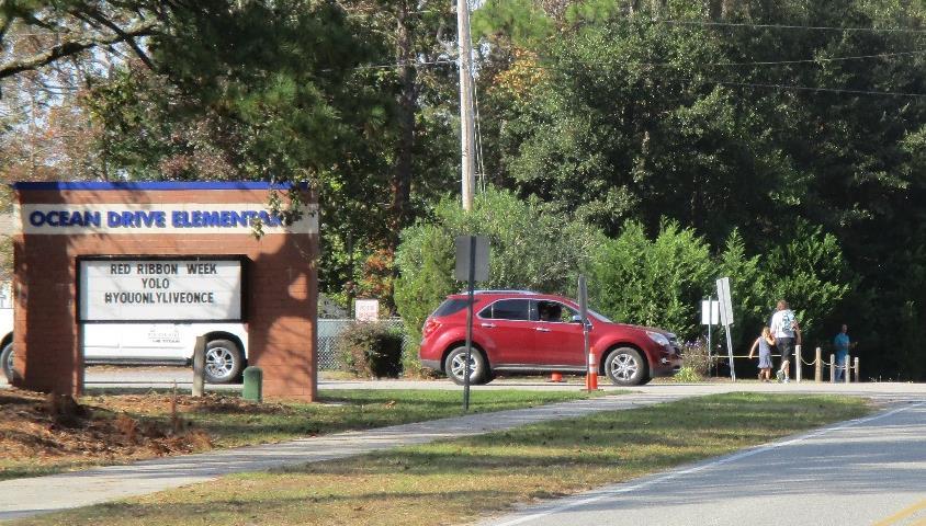

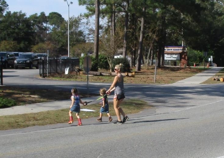
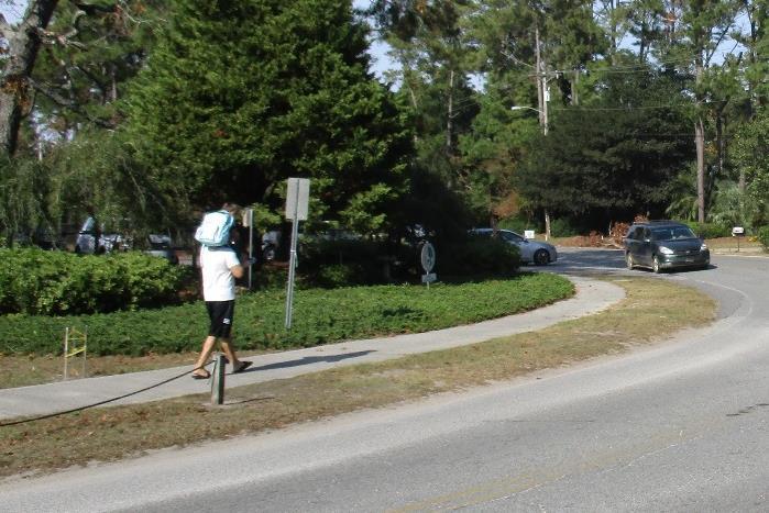

1 OCEAN DRIVE ELEMENTARY SCHOOL North Myrtle Beach, SC Safe Routes to School Travel Plan JANUARY 2017
2 SRTS Team Roster SRTS Team members represent key community stakeholders, share work of developing the plan, contribute diverse perspectives, build consensus around plan recommendations, and help implement the plan once it s adopted. Name Title or Role Organization or Affiliation Renea Fowler Principal Ocean Drive Elementary Jon Hoffnagle PE Teacher Ocean Drive Elementary Tom Maillet Parent Ocean Drive Elementary Jonathon Smith Parent Ocean Drive Elementary Holly Heniford Board Horry County Member School Board Joe Burch Coordinator Horry County of Planning Schools Travis Dupree Planner City of North Myrtle Beach School Michael James Operations SCDOT Engineer Safe Routes to Rodney Oldham School SCDOT Coordinator Jennifer Senn School SC SRTS Resource Outreach Center Coordinator Andrea Kelsey School Outreach Coordinator SC SRTS Resource Center RAnderson@horrycountyschools.net JHoffnagle@horrycountyschools.net thomasmaillet@yahoo.com JSSP436@aol.com Holly.Heniford@HorryCountySchools.net Jbirch@horrycountryschools.net tedupree@nmb.us jamesmt@scdot.org OldhamR@scdot.org JenniferS@scsaferoutes.org Andrea@scsaferoutes.org 1
3 Primary Contact Name Title Primary Contact Renea Fowler Principal Affiliation Phone Number Address Ocean Drive Elementary (843) Mailing Address th Ave N. North Myrtle Beach, SC Name Title Primary Contact Jon Hoffnagle PE Teacher Affiliation Phone Number Address Ocean Drive Elementary (843) Mailing Address th Ave N. North Myrtle Beach, SC Vision Statement This plan will be directed by the school and the school community and will incorporate their input. It will propose strategies to improve safety for walkers, bus riders, and car riders entering and exiting the school property. It will also address concerns within the school community about traffic on 11 th Avenue and on Jordon Road by proposing strategies to encourage and enable more students to walk and bicycle to school. 2
4 What is the makeup of the Student Population? Number and Percentage of Students by Category Category of Students # % Total Student Enrollment % Pre-K (with disabilities) % Special Education (self-contained) % K % 1st grade % 2nd grade % 3rd grade % 4th grade % 5th grade % Enrolled in programs before school % Enrolled in programs after school %-8.0% Eligible for school bus service All students who live further than 1 mile approximately 95% Eligible for Free and Reduced Lunch % With disabilities % 3
5 When do students arrive and depart school? Student Arrival and Departure Times Arrival Times When do before school programs begin, or what is the earliest students generally arrive at school? When do most students arrive at school? When does the school start bell start ring? 6:50 a.m. during the five months of the school when the pre-algebra program is active; otherwise, 7:00 a.m. 7:00 a.m., when buses begin unloading. 7:30 a.m. Departure Times When does the school end bell ring? When do most students depart school? When do after school programs end, or what is the latest students generally depart school? The first end bell rings at 2:30 p.m. for Child Development (CD), K, and 1 st grade. The second end bell rings at 2:35 p.m. for 2 nd, 3 rd, 4 th, and 5 th grade. Bus riders typically depart the school property by 2:45 p.m., accounting for approximately ½ the school population. Car riders typically depart between 2:30 p.m. and 2:55 p.m., during which the flow of departing car riders is relatively constant. By 3:05 p.m. most students have departed the school. 6:00 p.m.; however, most students in the afterschool Kid Care depart before 6:00 p.m. How are students currently getting to and from school? Number and Percentage of Students by Travel Mode to and from School To School From School Travel Mode % % Walk 1.5% 3.0% Bike 0.1% 0.1% School Bus 32.0% 52.5% Family Vehicle 64.5% 40.0% 4
6 Carpool 1.5% 2.0% Transit 0.4% 1.4% Other 0.0% 1.0% What is the potential to increase the share of students who walk and bicycle to school? Student Distance from School* # % Less than ¼ mile 6 0.7% ¼ mile up to ½ mile % ½ mile up to 1 mile % 1 mile up to 2 miles % More than 2 miles % *These calculations are based on street network distance. They do not take into account existing or potential pedestrian and bicycle connections that are not part of the street network. They also do not take into account new development planned for the east side of 11 th Avenue. 5

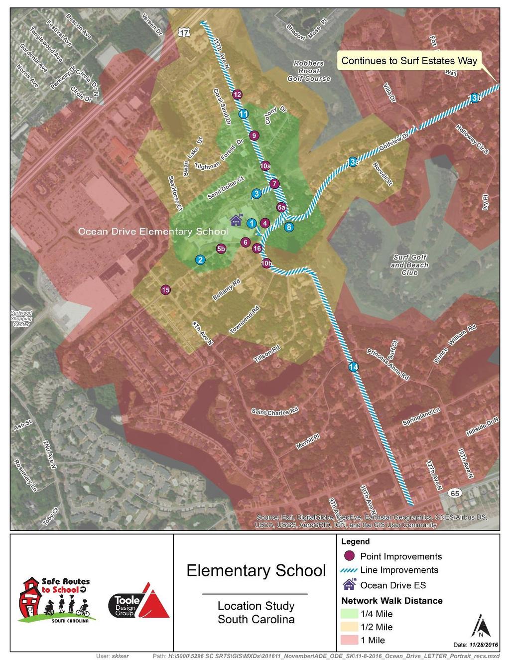
7 Where are the primary current and potential walking and bicycling routes? Map of School Area with Current and Potential Walking and Bicycling Routes 6
8 What are the issues related to walking and bicycling? Top Issues Reported by Parents 1. There are no sidewalks in the school parking lot and only one marked crosswalk, which connects the sidewalk at the front of the school to the visitor parking lot. Consequently, drivers do not know where to expect pedestrians, and pedestrians often mix with motor vehicle traffic. 2. There are no marked crosswalks on 11 th Avenue and there is no sidewalk on the east side of 11 th Avenue in the vicinity of the school. Top Issues Reported by School Staff Members 3. Drivers do not expect children walking and bicycling th Avenue is used as a cut-through road, which results in additional traffic at arrival and dismissal times. 5. Motor vehicles appear to be speeding, particularly on 11th Avenue. Have there been any specific safety incidents or concerns? List of location-specific safety concerns raised by the school principal, parents, students, or others Location Safety Concern(s) 11 th Avenue and Golf Drive A parent reported a recent near miss at this location while trying to cross 11 th Avenue with her three children. 7
9 How do existing policies and procedures impact walking and bicycling? Arrival and Dismissal Policies and Procedures Arrival Policies and Procedures What entrances do student walkers and bikers use to enter the school building during arrival? Do crossing guards assist student walkers and bikers during arrival? If so, where are the crossing guards located, and when are they at these locations? Do other members of the school community (e.g., school staff members, parents, Student Safety Patrol members) assist student walkers and bikers during arrival? If so, how do they assist, where are they located, and when are they at these locations during arrival? Student walkers and bikers enter through the Bus Entrance doors, which are located to the left of the front entrance when facing the school from 11 th Avenue. This door also serves as the entrance and exit for bus riders. No. The principal and PE teacher take turns monitoring a marked crosswalk on the school property that is on the far right side from the front of the building. Currently, two families cross at this location. Dismissal Policies and Procedures Does the school dismiss student walkers and bikers earlier, later, or at the same time as other students? What exits do student walkers and bikers use to leave the school building at dismissal? Do crossing guards assist student walkers and bikers during dismissal? If so, where are the crossing guards located, and when are they at these locations during dismissal? Student walkers and bikers are dismissed after the school buses depart the school property. Student walkers and bikers exit out of the Bus Entrance doors located to the left of the main entrance when facing the school from 11 th Avenue. No. 8
10 Do other members of the school community (e.g., school staff members, parents, Student Safety Patrol members) assist student walkers and bikers during dismissal? If so, how do they assist, where are they located, and when are they at these locations during dismissal? A teacher holds student walkers and bikers in the cafeteria until the buses leave and then walks them to the gate where the bus lane exits onto 11 th Avenue. Does the school or school district have any policies or procedures that limit student walking? If so, please describe. Does the school or school district have any policies or procedures that limit student biking? If so, please describe. How is eligibility for school bus service determined? Other Policies and Procedures No. No. In general, students must live within the school attendance area and more than 1 mile from the school to be eligible for school bus transportation. However, exceptions are made when hazardous conditions are identified. For example, school bus service is provided to students who live on Golf View Road and there is a bus stop at the intersection of 11 th Avenue and Hillside Drive. 9
11 What is already being done to encourage walking and bicycling and make it safer? Current Encouragement, Education, and Enforcement Activities/Programs to Encourage Walking and Bicycling and Make it Safer Activity or Program International Walk to School Day SC Walk to School Day Walk to the Beach Bicycle Rack Installation Description Ocean Drive Elementary School participates in International Walk to School Day. Students are encouraged to walk from home or to walk from established meet-up locations at the nearby Home Depot or Food Lion parking lots. Ocean Drive Elementary School participates in SC Walk to School Day. Students are encouraged to walk from home or to walk from established meet up locations at the nearby Home Depot parking lot. Ocean Drive Elementary School conducts an annual Walk to the Beach in latespring. Students walk down 11 th Avenue. A bicycle rack was installed near the Bus Entrance during the school year. Education, Encouragement, or Enforcement Encouragement Encouragement Encouragement Engineering 10
12 Issues Pedestrian and Bicycle Infrastructure The top Issues associated with pedestrian and bicycle infrastructure include: 1. School sidewalk network does not connect to street sidewalk network. The sidewalk along the school bus drop-off/ pick-up lane does not connect to the sidewalk on 11 th Avenue. The sidewalk along the 3 rd -5 th grade drop-off/pick up lane does not connect to Jordon Road. The lack of connections between the school sidewalk network and the on-street sidewalk network forces students and adults to walk in motor vehicle lanes, creating a safety concern. 2. Pedestrian priority not indicated where sidewalks cross school driveways. Driveway/sidewalk intersections on 11 th Avenue and Jordon Road are not designed to signal pedestrian priority to drivers, e.g., by using marked crosswalks or by continuing the sidewalk across the driveway opening. Drivers are less likely yield to pedestrians at driveway/sidewalk intersections where pedestrian priority is not indicated. 3. Insufficient lighting on Jordon Road The sidewalk on Jordon Road is not well lit along the school frontage, including at the 3 rd - 5 th grade drop-off/pick-up lane exit. The sidewalk on Jordon Road provides access between the designated school entrance/exit for student walkers and bikers at the front of the school and student residences southwest of the school. Student walkers and bikers begin arriving as early as 6:50 a.m. At certain times of year (e.g., in the fall toward the end of Daylight Savings Time) it is dark at this hour. The school also has a variety of afterschool activities that let out after dark in the fall and winter. The lack of lighting makes this section of sidewalk feel unsafe when it is dark. 5. Lack of marked pedestrian crossings and other pedestrian crossing support measures at key student crossing locations There are currently no marked pedestrian crossings within ¼ mile of the school property, including at the following key student crossing locations. o Across 11 th Avenue at Golf View Drive. o Across Jordon Road at 11 th Avenue. o Across 8 th Avenue at Jordon Road. 11
13 11 th Avenue is a two-lane road with one motor vehicle travel lane in each direction and continuous sidewalk on the west side of the street between Highway 17 and Ocean Boulevard. Average Daily Traffic between Highway 17 and Hillside Drive was 4,000 vehicles per day in 2015 according to SCDOT s Average Daily Traffic Counts web page. Much of this traffic occurs during arrival and dismissal times, making it difficult for students and adults to find gaps in traffic in order to cross to access the school. There are no STOP signs or traffic lights on 11 th Avenue between Highway 17 and Ocean Boulevard to assist with crossing. 8 th Avenue is a two-lane road with one motor vehicle travel lane in each direction and continuous sidewalk on the west side of the street between Highway 17 and Ocean Boulevard (with the exception of a short gap near Highway 17). Average Daily Traffic on 8 th Avenue is not available from SCDOT s Average Daily Traffic Counts web page; however, relatively high traffic volumes were observed at school arrival and pedestrians had to wait for a gap sufficient to cross as motor vehicles did not stop. There are STOP signs for traffic on 8 th Avenue at Hillside Drive. Otherwise, there are no STOP signs or traffic lights on 11 th Avenue between Highway 17 and Ocean Boulevard to assist with crossing. Jordon Road is a two-lane road with one motor vehicle travel lane in each direction and continuous sidewalk on the north side of the street between 11 th Avenue and 8 th Avenue. Average Daily Traffic on 8th Avenue is not available from SCDOT s Average Daily Traffic Counts web page; however, Jordon Road carries all school traffic associated with 3 rd -5 th grade arrival and dismissal due the location of the 3 rd -5 th grade drop-off/pick-up loop. There is a STOP sign at 11 th Avenue for traffic on Jordon Road. Lack of sidewalks along key pedestrian crossing routes Within a ½ mile radius of the school, sidewalks are present only on one side of Highway 17, 11 th Avenue, 8 th Avenue, Jordon Road, Bellamy Road, Hillside Drive, and Ocean Boulevard. Sidewalks are present on both sides of street in the newer development of Sea Vista Lane, which is a continuation of Jordon Road west of 8 th Avenue. Sidewalks are not present on some key existing and potential walking routes, including Golf View Drive, which links to neighborhoods east of the school. 12
14 Arrival and Dismissal Procedures or Behaviors The top Issues associated with arrival and dismissal procedures or behaviors include: 1. Motor vehicle speeds on 11 th Avenue The speed limit on 11th Avenue is 35 mph outside of the school zone and 15 mph inside of the school zone. The school zone speed limit applies at all times of day and the school zone extends from just north of the school property on 11th Avenue to Bellamy Road. Motor vehicle speeds in the school zone were checked during arrival and dismissal times using a radar gun. Multiple vehicles were observed traveling faster than 35 mph in the school zone. Several motor vehicles were observed traveling faster than 40 mph. 2. Vehicle volumes at drop off and pick up times Currently, 64.5% of students are dropped off in a family vehicle and 40.0% of students are picked up in a family vehicle. Enrollment at Ocean Drive Elementary School has increased rapidly in recent years and is likely to increase further in future years due to planned development on the east side of 11 th Avenue across from the school. There is insufficient on-campus queuing space to accommodate all family vehicles, particularly at dismissal. The queue for 3 rd -5 th grade pick-up extends onto Jordon Road. The North Myrtle Beach Police Department instructs drivers to double stack on Jordon Road to avoid the queue backing up onto 8 th Avenue. In order not to block Jordon Road, the Police Department advises one line of drivers to line up with one wheel on the Jordon Road sidewalk, which is at the same level as the road (i.e., no curb). The State Fire Marshall has provided direction to schools prohibiting family vehicles from double-stacking at drop off and pick up locations. This will further lengthen existing queues at arrival and dismissal, since the school currently double stacks family vehicles at these locations. 3. Concerns about pedestrian and bicyclist safety Pedestrian and bicyclist safety is a key concern for parents and staff members. Drivers, pedestrians, and bicyclists do not always behave in ways that enhance pedestrian and bicyclist safety. Behaviors observed during arrival and dismissal included: drivers exceeding the speed limit on 11 th Avenue, drivers failing to yield to pedestrians at unmarked crosswalks, pedestrians walking in motor vehicle travel lanes, and pedestrians crossing motor vehicle travel lanes at locations where crosswalks are not present (unmarked or marked). 13
15 4. Parents concerned about school arrival/dismissal policy changes During the school year, Horry County Public Schools attempted to revise Ocean Drive Elementary School s arrival and dismissal procedure. Members of the school community, including parents and the school administration, did not feel they had been adequately consulted about the revisions. The revised arrival and dismissal procedure proved unworkable from school s perspective, because it resulted in the drop-off/pick-up queue backing up onto 11 th Avenue. Consequently, the school and the school district worked to re-revise it. The school perceives the current arrival and dismissal procedure as working well and is concerned that revisions to this procedure may have adverse effects. 5. No comfortable place for parents/guardians of student walkers and bikers to wait for students before dismissal Student walkers and bikers exit from the Bus Entrance at dismissal. There are no shaded benches near this entrance where parents/guardians of student walkers can comfortably wait for their student to be dismissed. 14
16 Opportunities Future Plan Planned widening of 11th Avenue Planned development east of 11th Avenue Planned redesign of school fire lane Why is this an opportunity? There are plans to widen 11th Avenue between Highway 17 and Golf View Road (approximately). The plan includes adding motor vehicle turn lanes and constructing a sidewalk on the east side of 11th Avenue between Highway 17 and north of Golf View Drive. There is an opportunity to improve this design to better accommodate pedestrians and bicyclists. A new development is planned on the east side of 11 th Avenue across from the school property. The development will include 155 new homes and will include a shared use path connecting to 11 th Avenue. There may be an opportunity to work with the developers to fund pedestrian and bicycle improvements on 11 th Avenue to provide better access to the school, to the beach, and to commercial establishments on Highway 17. The Fire Marshall has informed the school that it needs to provide a fire lane along the CD-2 nd drop-off/pick-up drive. In conjunction with widening the driveway, it may also be possible to install a sidewalk along the drive, which could serve families accessing the school property from Sand Dollar Court. Name of Organization SCDOT How they can help Provide advice regarding the school s arrival/dismissal procedure. Work with the City of North Myrtle Beach to modify the 11 th Avenue design to improve pedestrian and bicycle access. 15

17 State Fire Marshall City of North Myrtle Beach Provide guidance regarding emergency access while also considering other key issues including limited play space, drainage, queuing on neighborhood streets, and pedestrian and bicycle access. Work with SCDOT, Horry County Schools, and local developers to modify the11 th Avenue design to improve pedestrian and bicycle access. Horry County Schools North Myrtle Beach Police Department Work with the City of North Myrtle Beach, SCDOT, and local developers to modify the 11 th Avenue design to improve pedestrian and bicycle access. Provide a crossing guard to assist pedestrians crossing 11 th Avenue. Provide periodic speed enforcement on 11 th Avenue. 16
18 Non-Infrastructure Strategies Education Strategies Strategy Issue(s) Addressed Priority Teach the NHTSA Child Pedestrian Concerns about pedestrian and bicyclist High Safety Curriculum safety Communicate with school parents and students any changes related to school arrival/dismissal, including reasons behind any routine changes Provide regular pedestrian and bicycle safety tips to students and their families Educate parents about traffic volume at dismissal times and methods of reducing traffic (walk, bus, carpool, park and walk, etc.) Concerns about pedestrian and bicyclist safety Concerns about pedestrian and bicyclist safety Vehicle volumes at drop off and pick up times High Medium High Enforcement Strategies Strategy Issue(s) Addressed Priority Implement periodic speed enforcement on 11 th Avenue during arrival and dismissal times. Motor vehicle speeds on 11th Avenue High Investigate the potential for providing a crossing guard to assist pedestrians crossing 11 th Avenue at arrival and dismissal times. Implement a parent pledge to drive the speed limit and yield to crossing pedestrians and bicyclists. Start a caught being good program to encourage better driver, biker, and pedestrian behavior. Lack of marked pedestrian crossings and other pedestrian crossing support measures at key student crossing locations Motor vehicle speeds on 11th Avenue Concerns about pedestrian and bicyclist safety High Medium 17
19 Encouragement Strategies Strategy Issue(s) Addressed Priority Increase the frequency of Walk to School Day events (e.g., weekly, monthly, bimonthly) Vehicle volumes at drop off and pick up times High Incentivize walking and bicycling from school and reduce conflicts between moving vehicles and pedestrians and bicyclists by allowing walkers and bikers to leave campus first at the end of the day. Establish a walking school bus program (weekly, monthly, bimonthly). Encourage and facilitate carpooling. Distribute maps of recommended walking routes to students and their families that also include information such as a 15 minute walk burns 100 calories and promotes academic achievement in the classroom. Establish a Take the bus to school day for students living greater than 1 mile from the school. Provide information including bus stop, bus number, and pick up/drop off time. Provide school bus service to students who live outside of the attendance boundary. Vehicle volumes at drop off and pick up times Concerns about pedestrian and bicyclist safety Vehicle volumes at drop off and pick up times Vehicle volumes at drop off and pick up times Vehicle volumes at drop off and pick up times Vehicle volumes at drop off and pick up times Vehicle volumes at drop off and pick up times. High Medium Medium Medium Low High Evaluation Strategies Strategy Issue(s) Addressed Priority Conduct a speed study on 11th Motor vehicle speeds on 11th Avenue High Avenue. Continue conducting student travel tallies annually to assess impact of SRTS programs. Conduct parent surveys to identify barriers to walking and biking to school. Vehicle volumes at drop off and pick up times Vehicle volumes at drop off and pick up times High Medium 18
20 Conduct a follow up safety assessment with the SRTS Resource Center to assess improvements and opportunities. Conduct a focus group with families living <1 mile from school to evaluate barriers and facilitate walking and bicycling to school. Concerns about pedestrian and bicyclist safety Vehicle volumes at drop off and pick up times Medium High Arrival and Dismissal Strategies Strategy Issue(s) Addressed Priority Consider revising the school arrival and dismissal process to prevent cars from obstructing the sidewalk on the north side of Jordon Road. Potential revisions include: Vehicle volumes at drop off and pick up times High Reverse the flow of traffic through the 3rd-5th grade drop-off/ pick-up lane. Maintain the Do Not Enter restriction at 11th Avenue Establish a right turn only restriction at the new 3rd-5th grade drop-off/ pick up lane exit Ask parents to queue single file on the south side of Jordon Road and not block driveways or drive on private property. or Ask parents to queue single file on the north side of Jordon Road and not obstruct the sidewalk or driveway exit. Note: Robust parent education and regular enforcement will be necessary regardless of whether parents are asked to queue on the south side or north side of Jordon Road. 19
21 Infrastructure Strategies 20
22 ID Location Strategy Issue(s) Addressed Priority 1 Campus Connect sidewalk next to school bus drop-off/ pick-up lane to 11th Avenue at bus drive exit. The existing sidewalk serves the Bus Entrance where student walkers and bikers enter and exit. 2 Campus Establish sidewalk connection between sidewalk adjacent to 3 rd -5 th grade drop-off/ pick-up lane and Jordon Road (west end only). Provide pedestrian gate at this location and adjust arrival/dismissal procedure to enable walkers to enter/exit the school building through the same entrance used by 3 rd -5 th grade car riders. 3 Campus Establish sidewalk connection between front of school and 11th Avenue at northeast corner of school property. Include marked high-visibility crosswalks where sidewalk intersects motor vehicle travel lanes 4 Campus Create a comfortable place for parents/guardians of student walkers and bikers to wait for their student outside of the Bus Entrance Doors. School sidewalk network does not connect to street sidewalk network. School sidewalk network does not connect to street sidewalk network. School sidewalk network does not connect to street sidewalk network. No comfortable place for parents/guardians of student walkers and bikers to wait for students before dismissal High High High Medium 21
23 ID Location Strategy Issue(s) Addressed Priority 5 School driveway openings 6 Jordon Road (along school frontage to 11 th Avenue( 7 11 th Avenue at CD-2nd grade school driveway opening 8 11 th Avenue/ Golf View Drive Mark high-visibility crosswalks. Incorporate median crossing island into CD-2nd grade school driveway opening to facilitate crossing. Install pedestrian-scale lighting (particularly near driveway exits). Establish pedestrian crossing across 11th Avenue. Support with marked high-visibility crosswalk, median crossing island, and crossing guard. Study intersection to determine if traffic signal or HAWK beacon is warranted based on future development conditions. Extend median island proposed in recommendation 7 to Golf View Drive th Avenue Consider modifying planted included in design for planned widening of 11 th Avenueto include cutthrough pedestrian refuge and marking high-visibility crosswalks and installing pedestrian crossing signage. Pedestrian priority not indicated where sidewalk crosses school driveways. Insufficient lighting on Jordon Road Lack of marked pedestrian crossings and other pedestrian crossing support measures at key student crossing locations Planned widening of 11 th Avenue Motor vehicle speeds on 11th Avenue Planned widening of 11 th Avenue Lack of marked pedestrian crossings and other pedestrian crossing support measures at key student crossing locations Planned widening of 11 th Avenue Medium Medium High High Medium 22
24 ID Location Strategy Issue(s) Addressed Priority th Avenue Install school zone speed limit signs and flashing beacons. Coordinate with SCHOOL pavement markings. Consider reducing speed limit on 11 th Avenue to 25 mph between HWY 17 and south of school with coordinated traffic calming measures and enforcement (to at least Princess Anne Drive) th Avenue Widen sidewalk on west side of 11 th Avenue between Jordon Road and HWY 17 to 7 feet or 5 feet with 2 buffer where feasible considering existing right of way. Construct sidewalk on east side of 11 th Avenue between proposed pedestrian crossing and Captain Hook s Way. Motor vehicle speeds on 11th Avenue Planned widening of 11 th Avenue Lack of sidewalks along key pedestrian crossing routes Planned widening of 11 th Avenue High High Or Install shared use path on west side of 11 th Avenue between HWY 17 and school property. Space could be captured by narrowing the center turn lane from 15 to
25 ID Location Strategy Issue(s) Addressed Priority th Avenue/ Tilghman Forest Drive Convert striped section on southwest corner to curb extension Planned widening of 11 th Avenue Medium 13 Golf View Drive Construct sidewalk on north side of roadway between 11 th Avenue to dead end path connection th Avenue Construct sidewalk on east side of 11 th Avenue between proposed Captain Hook s Way and Ocean Boulevard Lack of sidewalks along key pedestrian crossing routes Lack of sidewalks along key pedestrian crossing routes Low Low Or Continue shared use path on west side 15 Jordon Road and 8 th Avenue Mark high-visibility crosswalk and add pedestrian crossing signage to support 8th Avenue crossing. Lack of marked pedestrian crossings and other pedestrian crossing support measures at key student crossing locations Low 24
26 ID Location Strategy Issue(s) Addressed Priority 16 Jordon Road and 11 th Avenue Mark high-visibility crosswalk across Jordon Road. Lack of marked pedestrian crossings and other pedestrian crossing support measures at key student crossing locations Medium Infrastructure Strategy Disclaimer These are preliminary infrastructure strategies and each location may require further engineering analysis, public input, design, and review by the appropriate agency(ies) prior to implementation. Furthermore, any permanent or temporary signage off school property would need to be pre-approved by the SCDOT or the County (whoever maintains the road where signage was being placed). 25
27 12-Month Strategy Calendar The 12-month Strategy Calendar on the following pages identifies education, encouragement, and enforcement strategies that are important and feasible within a one-year timeframe. It also details who is going to be involved and the step-by-step process of implementing each strategy. The non-infrastructure strategy is indicated in the left-hand column. Note that the lead coordinator will not necessarily implement the activity alone but will be responsible for initiating planning and recruiting others to help. The shading indicates the months during which planning will take for an activity, and an X indicates the month when the activity will take place. For ongoing activities, there is an X for each month during which the activity will take place. First Year Infrastructure Implementation This table, found at the end of this section, keeps track of potential funding opportunities for high priority infrastructure strategies. The infrastructure strategy is indicated in the left-hand column. The lead coordinator is indicated in the second column by name and title as appropriate. The lead coordinator is responsible for identifying potential funding sources and keeping track of application deadlines and requirements. The lead coordinator may also serve as a liaison with local government for communications regarding this strategy. The remaining columns indicate the most likely potential funding source, the deadline for applications (if applicable), and key application requirements. 26
28 Non-Infrastructure Strategy Teach the NHTSA Child Pedestrian Safety Curriculum Communicate with school parents and students any changes related to school arrival/dismissal, including reasons behind any routine changes Educate parents about traffic volume at dismissal times and methods of reducing traffic (walk, bus, carpool, park and walk, etc.) Lead Coordinator Jon Hoffnagle Sue Wilson (data collection) Jon Hoffnagle, Sue Wilson 1 Jan X 2 Feb X 3 March 4 April 5 May 6 June Month 7 July 8 Aug X 9 Sept 10 Oct 11 Nov 12 Dec 27
29 Non-Infrastructure Strategy Increase the frequency of Walk to School Day events (e.g., weekly, monthly, bimonthly) Incentivize walking and bicycling from school and reduce conflicts between moving vehicles and pedestrians and bicyclists by allowing walkers and bikers to leave campus first at the end of the day. Implement periodic speed enforcement on 11 th Avenue during arrival and dismissal times Lead Coordinator Jon Hoffnagle, Sue Wilson Jon Hoffnagle Renea Fowler, Parent Officer 1 Jan 2 Feb X 3 March 4 April 5 May X X X X X 6 June Month 7 July 8 Aug 9 Sept X 10 Oct 11 Nov 12 Dec X X X X X 28
30 Non-Infrastructure Strategy Conduct a speed study on 11 th Avenue Lead Coordinator SCDOT 1 Jan 2 Feb 3 March X 4 April 5 May 6 June Month 7 July 8 Aug 9 Sept 10 Oct 11 Nov 12 Dec Continue conducting student travel tallies to assess impact of SRTS programs Jon Hoffnagle, Renea Fowler X 29
31 Infrastructure Strategy Lead Coordinator Potential Funding Source Connect sidewalk next to Mark Wolfe, Renea Transportation school bus drop-off/pick-up Fowler Alternatives Setlane to 11 th Avenue at bus Aside drive exit. The existing sidewalk serves the Bus (Alternative: Horry entrance where student County Public walkers and bikers enter and Schools) exit Establish sidewalk connection between sidewalk adjacent to 3 rd 5 th grad drop-off/pick-up land and Jordan Road (west end only). Provide pedestrian gate at this location and adjust arrival/dismissal procedure to enable walkers to enter/exit the school building through the same entrance used by 3 rd - 5 th grade car riders Establish sidewalk connection between front of school and 11 th Avenue at northeast corner of school property. Include marked high-visibility crosswalks where sidewalk intersects motor vehicle travel lanes. Mark Wolfe, Renea Fowler Mark Wolfe, Renea Fowler Transportation Alternatives Set- Aside (Alternative: Horry County Public Schools) Transportation Alternatives Set- Aside (Alternative: Horry County Public Schools) Application Deadline Applications are accepted year round. Applications are accepted year round. Applications are accepted year round. Key application Requirements Requires a 20% local match. $400K cap on SCDOT TAP projects Must identify eligible project sponsor Must hold public meeting Requires a 20% local match. $400K cap on SCDOT TAP projects Must identify eligible project sponsor Must hold public meeting Requires a 20% local match. $400K cap on SCDOT TAP projects Must identify eligible project sponsor Must hold public meeting 30
32 Infrastructure Strategy Lead Coordinator Potential Funding Source Establish pedestrian crossing Travis Dupree, City of Transportation across 11 th Avenue. Support North Myrtle Beach Alternatives Setwith marked high-visibility Aside crosswalk, median crossing island, and crossing guard. (Alternative: Horry Study intersection to County Public determine if traffic signal or Schools) HAWK beacon is warranted based on future development conditions Extend median island proposed in recommendation to Golf View Drive Travis Dupree, City of North Myrtle Beach Transportation Alternatives Set- Aside Application Deadline Applications are accepted year round. Applications are accepted year round. Key application Requirements Requires a 20% local match. $400K cap on SCDOT TAP projects Must identify eligible project sponsor Must hold public meeting Requires a 20% local match. $400K cap on SCDOT TAP projects Must identify eligible project sponsor Must hold public meeting Install school zone speed limit signs and flashing beacons; Coordinate with SCHOOL pavement markings; Consider reducing speed limit on 11 th Avenue to 25 mph between HWY 17 and south of school with coordinated traffic calming measures and enforcement (to at least Princess Anne Drive) Travis Dupree, City of North Myrtle Beach Transportation Alternatives Set- Aside Applications are accepted year round. Requires a 20% local match. $400K cap on SCDOT TAP projects Must identify eligible project sponsor Must hold public meeting 31
33 Infrastructure Strategy Lead Coordinator Potential Funding Source Widen sidewalk on west side Travis Dupree, City of Transportation of 11 th Avenue between North Myrtle Beach Alternatives Set- Jordan Road and HWY 17 to Aside 7 feed or 5 feed with 2 foot buffer where feasible considering existing right of way. Construct sidewalk on east side of 11 th Avenue between proposed pedestrian crossing and Captain Hook s Way. OR Install shared use path on west side of 11 th Avenue between HWY 17 and school property. Space could be captured by narrowing the center turn lane from 15 feet to 12 feet. Application Deadline Applications are accepted year round. Key application Requirements Requires a 20% local match. $400K cap on SCDOT TAP projects Must identify eligible project sponsor Must hold public meeting 32
34 Public Input Process and Endorsements The table below briefly describes the public input strategies used to gather input on the draft SRTS travel plan from school, community, and government representatives. Strategies Used to Get Input on the Draft SRTS Travel Plan Category Strategies Used Key Feedback Provided School Community Requested review from Principal and School Champion Present travel plan at neighborhood association meetings Government Requested review from City of North Myrtle Beach and SCDOT 33

35 Plan Endorsements The undersigned pledge support for the Ocean Drive Elementary School SRTS Travel Plan and SRTS program. Renea Fowler School Principal, Ocean Drive Elementary Travis Dupree Public Works Engineering Manager, City of North Myrtle Beach Jon Hoffnagle PE Teacher, Ocean Drive Elementary Rick Maxey, Ph. D. Superintendent, Horry County Public Schoolr 34
July 5, Arthur R. Ware, Jr. Elementary School 2017 Safe Routes to School Walkabout Report
 July 5, 2017 Arthur R. Ware, Jr. Elementary School 2017 Safe Routes to School Walkabout Report 1 Walkabout Report Introduction On April 28, 2017, City, School, and SAWMPO staff met to conduct a Safe Routes
Wellington Exempted Village School District SAFE ROUTES TO SCHOOL TRAVEL PLAN January 2014
 Wellington Exempted Village School District SAFE ROUTES TO SCHOOL TRAVEL PLAN January 2014 OHIO SAFE ROUTES TO SCHOOL WELLINGTON EXEMPTED VILLAGE SCHOOL DISTRICT TRAVEL PLAN SECTION 1: WELLINGTON EXEMPTED
Conway Elementary School
 Conway Elementary School Safe Routes to School Travel Plan February 2012 Prepared with assistance from the SC SRTS Resource Center INTRODUCTION This Travel Plan represents the work of the Conway Elementary
SAFE ROUTES TO SCHOOL
 SAFE ROUTES TO SCHOOL Forest Ridge Elementary School Existing Conditions and ACTION PLAN > Oak Creek - Franklin Joint School District Table of Contents CONTEXT Enrollment Boundaries
Arlington Public Schools Thomas Jefferson Site Evaluation Transportation Networks. Thomas Jefferson Working Group Meeting #6 November 10, 2014
 Arlington Public Schools Thomas Jefferson Site Evaluation Transportation Networks Thomas Jefferson Working Group Meeting #6 November 10, 2014 2 3 INTRODUCTION 4 Goal of our work: Identify and assess multi-modal
CITY OF OAK CREEK SAFE ROUTES TO SCHOOL ACTION PLAN. East Middle School
 CITY OF OAK CREEK SAFE ROUTES TO SCHOOL ACTION PLAN East Middle School CITY OF OAK CREEK SAFE ROUTES TO SCHOOL ACTION PLAN East Middle School Why Safe Routes to School? Safe Routes to School ( SRTS ) is
Caltrans Sloat Boulevard Pedestrian Safety Project Response to Community Questions, Comments & Concerns
 Caltrans Sloat Boulevard Pedestrian Safety Project Response to Community Questions, Comments & Concerns Revised: May 10, 2016 The California Department of Transportation (Caltrans) is planning various
SAFE ROUTES TO SCHOOL
 SAFE ROUTES TO SCHOOL Edgewood Elementary School Existing Conditions and ACTION PLAN > Oak Creek - Franklin Joint School District Table of Contents CONTEXT Enrollment Boundaries Enrollment
C/CAG. Sunnybrae Elementary School Walking and Bicycling Audit. San Mateo-Foster City School District JUNE 2013
 Sunnybrae Elementary School Walking and Bicycling Audit JUNE 2013 San Mateo-Foster City School District C/CAG City/County Association of Governments of San Mateo County SUNNYBRAE ELEMENTARY SCHOOL WALKING
Sebastopol Charter School Traffic Management Plan
 Sebastopol Charter School The serves as the working document in support of these essential goals: to ensure the safety and efficiency of student arrival to and departure from school to ensure the safety
Implementing the Three Es of School Zone Traffic Calming
 Implementing the Three Es of School Zone Traffic Calming Use this evaluation tool as a guide to analyze the specific safety needs of your school. SCHOOL PROFILE School Name: School District: Address: Phone
Vallecito Elementary School. Travel Plan
 Vallecito Elementary School Travel Plan TABLE OF CONTENTS 1. PURPOSE... 1 1.1. SR2S PLANNING, IMPLEMENTATION AND MONITORING... 1 1.2. MARIN COUNTY MEASURE A... 1 2. VALLECITO ELEMENTARY SCHOOL PROFILE...
Why Zone In on Speed Reduction?
 Learn it. Do it. Live it! SPEED REDUCTION IN THE ZONE Why Zone In on Speed Reduction? Speeding is a serious issue that plays a major role in the risk of serious injury and pedestrian fatality in a crash.
Agenda. Overview PRINCE GEORGE S PLAZA METRO AREA PEDESTRIAN PLAN
 PRINCE GEORGE S PLAZA METRO AREA PEDESTRIAN PLAN May 28, 2008 Agenda Welcome and introductions Project overview and issue identification Planning context and strengths Design challenges and initial recommendations
3 Silverton High School Report
 3 Silverton High School Report Principal: Justin Lieuallen Grades: 9-12 Enrollment: 1,277 Address: 1456 Pine Street First bell: 7:55 a.m. Silverton, OR 97381 Last bell: 3:05 p.m. Free & Reduced Lunch:
Bicycle Facilities Planning
 Bicycle Facilities Planning Overview Types of Cyclists Purpose for Riding Types of Facilities Bike Lanes Bicycle Boulevards Cycle Tracks Intersections Signals Signing and Marking Discussion Types of Bicyclists
Sunset Park Center for Accelerated Studies
 Sunset Park Center for Accelerated Studies The following are a simple list of advantages, disadvantages, and recommendations based on a community assessment. It is not intended to be a list of complete
2 Mark Twain Elementary School Report
 2 Mark Twain Elementary School Report Principal: Greg Kaatz Grades: K-2 Enrollment: 323 Address: 425 N. Church Street First bell: 8:10 a.m. Silverton, OR 97381 Last bell: 2:30 p.m. Free & Reduced Lunch:
Bikeway action plan. Bicycle Friendly Community Workshop March 5, 2007 Rochester, MN
 Bikeway action plan Summary The was held on March 5, 2007 at the Rochester Mayo Civic Center. The workshop was hosted by Rochester-Olmsted County Planning Department in collaboration with the League of
Drag and drop pic and stretch/crop to the limits of the blue rectangle (delete this text box) Maxey Elementary School
 Maxey Elementary School") Drag and drop pic and stretch/crop to the limits of the blue rectangle (delete this text box) Maxey Elementary School SCHOOL ROUTE PLAN For MAXEY ELEMENTARY SCHOOL LOCATION 33 ORANGE COUNTY Prepared for:
Drag and drop pic and stretch/crop to the limits of the blue rectangle (delete this text box) Maxey Elementary School SCHOOL ROUTE PLAN For MAXEY ELEMENTARY SCHOOL LOCATION 33 ORANGE COUNTY Prepared for:
PRINCE GEORGE S PLAZA METRO AREA PEDESTRIAN PLAN
 PRINCE GEORGE S PLAZA METRO AREA PEDESTRIAN PLAN May 28, 2008 Agenda Welcome and introductions Project overview and issue identification Planning context and strengths Design challenges and initial recommendations
Safe Routes to School Comprehensive Plan
 Safe Routes to School Comprehensive Plan City of Apple Valley Dakota County, MN May 2010 Prepared by: Project Background The Statewide Health Improvement Program (SHIP) aims to help Minnesotans live longer,
5 Transit & Traffic. Overview
 5 Transit & Traffic Overview Montgomery Place s roadways and overall traffic circulation are unique in the city due to the narrow streets and avenues with boulevards; however, no sidewalks or curbs in
Rim Rock Elementary School Walking and Biking Audit
 Rim Rock Elementary School Walking and Biking Audit September 29, 2016 Rim Rock Elementary School Audit for Walking and Biking September 29, 2016 Audit Team Members: Sam Atkins, City Engineer, City of
Broad Street Bicycle Boulevard Design Guidelines
 Broad Street Bicycle Boulevard Design Guidelines Building from the strategies introduced in the 2013 Bicycle Transportation Plan and community input received thus far, City Transportation Staff have identified
Chapter 2. Bellingham Bicycle Master Plan Chapter 2: Policies and Actions
 Chapter 2 Bellingham Bicycle Master Plan Chapter 2: Policies and Actions Chapter 2: Policies and Actions The Bicycle Master Plan provides a road map for making bicycling in Bellingham a viable transportation
Watertown Complete Streets Prioritization Plan. Public Meeting #1 December 14, 2017
 Watertown Complete Streets Prioritization Plan Public Meeting #1 December 14, 2017 Goals for Public Meeting Overview of MassDOT Complete Streets Funding Program Educate the community on Complete Streets
About the Studio. Edward J. Bloustein School of Planning and Public Policy - Rutgers University
 About the Studio Edward J. Bloustein School of Planning and Public Policy - Rutgers University Purpose of studio: Help City of Bayonne apply for Safe Routes to School (SRTS) funding by producing a School
Chapter 3.9 Timbercrest Elementary School. Volusia County MPO. November 2008
 Chapter 3.9 Timbercrest Elementary School Deltona, FL Volusia County MPO November 2008 Volusia County MPO School Bicycle and Pedestrian Review Study, Phase 3B School Summary Timbercrest Elementary School
SECTION 1 - CONTACT INFORMATION
 SECTION 1 - CONTACT INFORMATION Please complete the information below. The person identified as the Project Contact Person will be the primary point of contact for Georgia DOT staff. Organization: (Please
San Ramon Elementary School. Travel Plan
 San Ramon Elementary School Travel Plan TABLE OF CONTENTS 1. PURPOSE... 1 1.1. SR2S PLANNING, IMPLEMENTATION AND MONITORING... 1 1.2. MARIN COUNTY MEASURE A... 1 2. SAN RAMON ELEMENTARY SCHOOL PROFILE...
TRAFFIC ACTION PLAN. North Central Neighborhood CITY OF SAN MATEO
 TRAFFIC ACTION PLAN North Central Neighborhood CITY OF SAN MATEO Draft February 2017 Table of Contents Introduction... 1 The Traffic Forum Process... 4 Neighborhood Traffic Issues... 6 Neighborhood Recommendations
ASHTABULA AREA SCHOOLS STP
 ASHTABULA AREA SCHOOLS STP SAFE ROUTES TO SCHOOL TRAVEL PLAN April 2013 OHIO SAFE ROUTES TO SCHOOL SCHOOL TRAVEL PLAN SECTION 1: OUR SCHOOL/S 1A. Identify Target Schools School District School Name School
EXECUTIVE SUMMARY. Vision
 Vision Walking and bicycling in Salt Lake City will be safe, convenient, comfortable, and viable transportation options that connect people to places, foster recreational and economic development opportunities,
CHILLICOTHE CITY SCHOOLS. SAFE ROUTES TO SCHOOL TRAVEL PLANS for Allen, Mt. Logan, Tiffin & Worthington Elementary Schools January 2013
 CHILLICOTHE CITY SCHOOLS SAFE ROUTES TO SCHOOL TRAVEL PLANS for Allen, Mt. Logan, Tiffin & Worthington Elementary Schools January 2013 i Ohio s Safe Routes to School Travel Plan Template www.dot.state.oh.us/saferoutes
SAFE ROUTES TO SCHOOL (SR2S)
") SAFE ROUTES TO SCHOOL (SR2S) In partnership with Burbank Unified School District (BUSD) & City of Burbank George Washington Elementary School Thomas Jefferson Elementary School John Muir Middle School
SAFE ROUTES TO SCHOOL (SR2S) In partnership with Burbank Unified School District (BUSD) & City of Burbank George Washington Elementary School Thomas Jefferson Elementary School John Muir Middle School
Arlington Public Schools Abingdon Elementary School Site Evaluation Preliminary Transportation Findings
 Arlington Public Schools Abingdon Elementary School Site Evaluation Preliminary Transportation Findings Arlington County Public Facilities Review Committee (PFRC) November 19, 2014 SAN ANTONIO-BEXAR COUNTY
Mary H Wright Elementary School
 Mary H Wright Elementary School Safe Routes to School Travel Plan February Prepared with assistance from the SC SRTS Resource Center INTRODUCTION This Travel Plan represents the work of the Mary H. Wright
Pearl Sample Elementary & A.G. Richardson Elementary Walkabout Report
 Pearl Sample Elementary & A.G. Richardson Elementary Walkabout Report Introduction On December 14, 2017, stakeholders at Pearl Sample Elementary School and A.G. Richardson Elementary School in Culpeper,
Chapter 3.3 Horizon Elementary School. Volusia County MPO. June 2009
 Chapter 3.3 Horizon Elementary School Port Orange, FL Volusia County MPO June 2009 Volusia County MPO School Bicycle and Pedestrian Review Study, Phase 3C School Summary Horizon Elementary School is located
Active Transportation Facility Glossary
 Active Transportation Facility Glossary This document defines different active transportation facilities and suggests appropriate corridor types. Click on a facility type to jump to its definition. Bike
CITY OF KASSON TRANSPORTATION ALTERNATIVES KASSON SAFE ROUTES TO SCHOOL
 ve ha 8t G B A Mantorville Ave N 240th Ave 16th St NE 11th Ave NE K-M HIGH SCHOOL SUNRISE TRAIL TO MANTORVILLE MNTH 57 SUNSET TRAIL TO MANTORVILLE NE PARK 16TH ST NE TRAIL K-M ELEMENTARY SCHOOL K-M MIDDLE
Bringing together community and health. Physical Activity and Nutrition Unit Office of Statewide Health Improvement Initiatives
 Bringing together community and health. Physical Activity and Nutrition Unit Office of Statewide Health Improvement Initiatives Physical Activity and Nutrition Unit Office of Statewide Health Improvement
Lawrence Safe Routes to School. Community Meeting January 14, 2015
 Lawrence Safe Routes to School Community Meeting January 14, 2015 Safe Routes to School The 6 E s Education Encouragement Enforcement Engineering Evaluation Equity What are the elements of a SRTS plan?
Safe Routes to School Travel Plan 2011 Reading-Fleming Intermediate School (RFIS)
") Safe Routes to School Travel Plan 0 Reading-Fleming Intermediate School (RFIS) Reading Fleming Intermediate School 50 Court Street Flemington, NJ 088 Grades: 5-6 Introduction Reading-Fleming Intermediate
Safe Routes to School Travel Plan 0 Reading-Fleming Intermediate School (RFIS) Reading Fleming Intermediate School 50 Court Street Flemington, NJ 088 Grades: 5-6 Introduction Reading-Fleming Intermediate
Windy Ridge Elementary School
 Windy Ridge Elementary School SCHOOL ROUTE PLAN For WINDY RIDGE ELEMENTARY SCHOOL LOCATION 54 ORANGE COUNTY Prepared for: ORANGE COUNTY SCHOOL ASSESSMENT PROGRAM ORANGE COUNTY PUBLIC WORKS Traffic Engineering
PROSPECT ELEMENTARY GIRARD INTERMEDIATE GIRARD JUNIOR HIGH
 PROSPECT ELEMENTARY GIRARD INTERMEDIATE GIRARD JUNIOR HIGH SAFE ROUTES TO SCHOOL SCHOOL TRAVEL PLAN January 8, 2014 2 SECTION 1: OUR SCHOOLS School District School Name School Address Grades served Girard
Introduction.
 2307-1.0. Introduction. Delaware s Safe Routes to School (SRTS) Program was established September 10, 2002 when Governor Ruth Ann Minner signed Senate Bill 353 of the 141st General Assembly of Delaware
» Draft Recommendations» Discussion» Next Steps. Plan for Walking and Biking
 SAC Meeting Plan #3 for September Walking and 12, Biking 2018 » Draft Recommendations» Discussion» Next Steps Plan for Walking and Biking » Stakeholder and Public Outreach» Background data collection and
S A F E R O U T E S T O S C H O O L H E R M A N TOW N S C H O O L S A N D P R O C TO R S C H O O L S P L A N A P P R OVA L S
 S A F E R O U T E S T O S C H O O L H E R M A N TOW N S C H O O L S A N D P R O C TO R S C H O O L S P L A N A P P R OVA L S WHAT IS SAFE ROUTES TO SCHOOL? In 1969, nearly 50% of children walked or rode
THORNVILLE-GLENFORD STP
 THORNVILLE-GLENFORD STP SAFE ROUTES TO SCHOOL TRAVEL PLAN September 2013 OHIO SAFE ROUTES TO SCHOOL SCHOOL TRAVEL PLAN SECTION 1: OUR SCHOOL/S 1A. Identify Target Schools School District School Name School
Bicycle and Pedestrian Advisory Committee (BPAC) November 21, 2013
 November 21, 2013") Bicycle and Pedestrian Advisory Committee (BPAC) November 21, 2013 OVERALL LAND USE CONCEPT Overall Broadway Valdez District: 95.5 acres (35.1 acres right-of ways + 60.4 acres developable land) Plan Subareas:
Bicycle and Pedestrian Advisory Committee (BPAC) November 21, 2013 OVERALL LAND USE CONCEPT Overall Broadway Valdez District: 95.5 acres (35.1 acres right-of ways + 60.4 acres developable land) Plan Subareas:
Guidance. ATTACHMENT F: Draft Additional Pages for Bicycle Facility Design Toolkit Separated Bike Lanes: Two-Way to One-Way Transitions
 ATTACHMENT F: Draft Additional Pages for Bicycle Facility Design Toolkit Separated Bike Lanes: Two-Way to One-Way Transitions This treatment provides a transition from two-way separated bike lanes to one-way
Triangle Elementary School Walkabout Report
 Triangle Elementary School Walkabout Report Introduction On May 30, 2018, stakeholders at Triangle Elementary School in Triangle, Virginia met to examine the walking and bicycling networks around the school
Environment and Public Works Committee Presentation
 Mixed Use Centers Complete Streets Guidelines Project Environment and Public Works Committee Presentation December 10, 2008 Project Objectives: Conduct an inter-departmental and agency process to study
Chapter 4.3 Enterprise Elementary. Volusia County MPO. March Page 7.0
 Chapter 4.3 Enterprise Elementary Enterprise, FL Volusia County MPO March 2008 Page 7.0 Volusia County MPO Bicycle and Pedestrian School Safety Review Study Introduction Enterprise Elementary School is
AGENDA. 5. Next Steps a. Survey Distribution b. Draft Action Plan/Recommendations c. Review at next meeting in advance of document preparation
 Congdon Elementary Safe Routes to School Plan Update SRTS Team Meeting #2-Walk Audit March 21, 2018, 3:00 p.m. Congdon Elementary School Art Room-Duluth, MN 1. Welcome and Introductions 2. SRTS Review
Chapter 5. Complete Streets and Walkable Communities.
 Chapter 5. Complete Streets and Walkable Communities. 5.1 Description of Complete Streets. Cities throughout the world, and specifically the United States, are coming to embrace a new transportation and
Meadow Woods Elementary School
 Drag and drop pic and stretch/crop to the limits of the blue rectangle (delete this text box) Meadow Woods Elementary School Drag and drop pic and stretch/crop to the limits of the blue rectangle (delete
COWETA HIGH SCHOOL AND EAST HIGHWAY 51
 COWETA HIGH SCHOOL AND EAST HIGHWAY 51 Lack of sidewalks along Ben Lumpkin Rd. Lack of crosswalks and ramps at intersection. Hwy 51 is wide to cross as a pedestrian. No ADA compliance or connection to
Safe Routes to School Action Plan Aberdeen, Idaho
 Background Aberdeen, Idaho is a largely agricultural community of nearly 2,000 people and is located in the southeast portion of the state on the western edge of American Falls Reservoir. The community
ARCADIA ELEMENTARY & MIDDLE SCHOOLS
 ARCADIA ELEMENTARY & MIDDLE SCHOOLS SAFE ROUTES TO SCHOOL TRAVEL August 2013 ARCADIA LOCAL SCHOOLS OHIO SAFE ROUTES TO SCHOOL SCHOOL TRAVEL Ohio Safe Routes to School Travel Plan Local Schools www.dot.state.oh.us/saferoutes
Solana Beach Comprehensive Active Transportation Strategy (CATS)
") Solana Beach Comprehensive Active Transportation Strategy (CATS) 3.0 Goals & Policies The Solana Beach CATS goals and objectives outlined below were largely drawn from the Solana Beach Circulation Element
Solana Beach Comprehensive Active Transportation Strategy (CATS) 3.0 Goals & Policies The Solana Beach CATS goals and objectives outlined below were largely drawn from the Solana Beach Circulation Element
Safe Routes to School Guide
 Safe Routes to School Guide Steps to Creating a Safe Routes to School Program Created February 2007 SafeRoutes National Center for Safe Routes to School This guide was developed by the Pedestrian and Bicycle
Walkabout Summary Report
 Walkabout Summary Report Introduction On September 3, 2014, stakeholders at Bessie Weller Elementary School (Bessie Weller ES) in Staunton, Virginia met to examine the walking and bicycling network around
Bremen Elementary. SAFE ROUTES TO SCHOOL TRAVEL PLAN October 9, 2012
 Bremen Elementary SAFE ROUTES TO SCHOOL TRAVEL PLAN October 9, 2012 Introduction The purpose of the Bremen Elementary Safe Route to School (SRTS) Plan is to encourage school age children to travel to school
Lake Whitney Elementary School
 Lake Whitney Elementary School SCHOOL ROUTE PLAN For LAKE WHITNEY ELEMENTARY SCHOOL LOCATION 18 ORANGE COUNTY Prepared for: ORANGE COUNTY SCHOOL ASSESSMENT PROGRAM ORANGE COUNTY PUBLIC WORKS Traffic Engineering
San Rafael School District. Task Force Meeting Notes. November 5, 2012
 San Rafael School District Task Force Meeting Notes November 5, 2012 Attendees (8) Wendi Kallins Program Director for Safe Routes to Schools; Laura Kelly Volunteer Liaison for Safe Routes to Schools; Leslie
Tonight is for you. Learn everything you can. Share all your ideas.
 Strathcona Neighbourhood Renewal Draft Concept Design Tonight is for you. Learn everything you can. Share all your ideas. What is Neighbourhood Renewal? Creating a design with you for your neighbourhood.
Board-Approved Funding Awards for Cycle 4 Active Transportation Grant Program Projects (in Order of Project Rankings) Approved on
 Approved on") CAPITAL Large Category Projects Board-Approved Funding Awards for Cycle 4 Active Transportation Grant Program Projects (in Order of Project Rankings) Approved on 07-27-18 1 La Mesa University Ave Pedestrian
CAPITAL Large Category Projects Board-Approved Funding Awards for Cycle 4 Active Transportation Grant Program Projects (in Order of Project Rankings) Approved on 07-27-18 1 La Mesa University Ave Pedestrian
Town of Mooresville, North Carolina Neighborhood Traffic Calming and Control Device Policy
 Town of Mooresville, North Carolina Neighborhood Traffic Calming and Control Device Policy Adopted January 6, 2014 Town of Mooresville Development Services Department TOWN OF MOORESVILLE NEIGHBORHOOD TRAFFIC
Table of Contents Introduction. 2 Purpose of the Plan...2 The Benefits of Walking and Bicycling...3 Vision and Goals of the Plan...
 BICYCLE AND This plan was created through a grant from the Healthy Communities Program with the cooperation of the City of Cynthiana, Cynthiana Main Street, Cynthiana-Harrison County-Berry Joint Planning
CURBSIDE ACTIVITY DESIGN
 5 CURBSIDE ACTIVITY DESIGN This chapter provides design guidance for separated bike lanes adjacent to curbside activities including parking, loading and bus stops. Typical configurations are presented
Citizen Advisory Group Meeting #8 May 5, Welcome. Today s meeting will focus on: Land Use & Transportation CHARLOTTEPLANNING.
 Citizen Advisory Group Meeting #8 May 5, 2010 Welcome. Today s meeting will focus on: Land Use & Transportation CHARLOTTEPLANNING.ORG Meeting Agenda Handouts: o Meeting Agenda o Summary of East Seventh
Transportation Planning Division
 Transportation Planning Division Presentation Outline Study Tasks Recap of Previous Meeting Stakeholder Interviews Data Collection Design Principles Tool Box Recommendations Schedule Moving Forward North
Parental Responsibilities
 Bicycle riding is a fun way to exercise and enjoy the outdoors. To remain safe on Illinois roads, bicyclists must obey the same traffic safety laws that govern vehicle drivers. No amount of bicycle safety
Safe Routes to School: Creating an Action Plan Template
 odot25m Page 1 4/13/2016-1 - Safe Routes to School: Creating an Action Plan Template Note: This document can be protected to prevent unintended changes to the form. If you wish to protect the template,
MINERAL AVENUE CORRIDOR ASSESSMENT STUDY IMPLEMENTATION STRATEGY
 MINERAL AVENUE CORRIDOR ASSESSMENT STUDY IMPLEMENTATION STRATEGY INTRODUCTION City Personnel Sign-in Sheet Comment Forms Please Write Down Any Feedback INTRODUCTION List of Topics for Presentation Study
SCHOOL CROSSING PROTECTION CRITERIA
 CITY OF MADISON TRAFFIC ENGINEERING SCHOOL CROSSING PROTECTION CRITERIA January 2016 Adopted as Policy on August 31, 1976, by Common Council by Amended Resolution #29,540 Amended on September 14, 1976,
Telegraph Avenue Complete Streets DRAFT Recommendations. Oakland Public Works Department September 11 and 13, 2014 Open Houses
 Telegraph Avenue Complete Streets DRAFT Recommendations Oakland Public Works Department September 11 and 13, 2014 Open Houses Presentation Overview What are complete streets? What problem are we trying
PEDESTRIAN ACTION PLAN
 ATTACHMENT 2 CITY OF SANTA MONICA PEDESTRIAN ACTION PLAN CITY OF SANTA MONICA PEDESTRIAN ACTION PLAN This page intentionally left blank EXECUTIVE SUMMARY CHAPTER 1 EXECUTIVE SUMMARY Setting the Stage
Transportation Planning Division
 Transportation Planning Division Presentation Outline Study Tasks Recap of Previous Meetings Data Collected Focus Areas within Study Limits Design Principles Tool Box Recommended Concepts Schedule Moving
Mineral Avenue Corridor Assessment. ITE 2017 Western District Annual Meeting San Diego, CA June 21 st
 Mineral Avenue Corridor Assessment ITE 2017 Western District Annual Meeting San Diego, CA June 21 st Biography - Aaron Heumann, PE, PTOE Currently City of Littleton Transportation Engineering Manager 24
City of Albert Lea Policy and Procedure Manual 4.10 ALBERT LEA CROSSWALK POLICY
 4.10 ALBERT LEA CROSSWALK POLICY PURPOSE: Pedestrian crosswalks are an integral part of our transportation infrastructure. To be effective and promote safety, marked crosswalks must be installed after
NORTH UNION LOCAL SCHOOLS
 NORTH UNION LOCAL SCHOOLS SAFE ROUTES TO SCHOOL TRAVEL PLAN November 2015 OHIO SAFE ROUTES TO SCHOOL SCHOOL TRAVEL PLAN SECTION 1: OUR SCHOOL(S) 1A. Identify Target Schools School District School Name
BETHEL ROAD AND SEDGWICK ROAD CORRIDOR STUDY
 DRAFT PLAN City Council Meeting August 14, 2017 STUDY AREA Sedgwick Corridor State Route 160, principal arterial with Class 3 access management designation, commuter and freight route, connection to SR
Complete Streets Chicago: Data Driven Design. Luann Hamilton Deputy Commissioner
 Complete Streets Chicago: Data Driven Design Luann Hamilton Deputy Commissioner AGENDA Chicago s goals Complete Streets & Sustainable Infrastructure Guides Data-Driven Planning Setting goals Scoping/research
Hidden Oaks Elementary School
 Hidden Oaks Elementary School SCHOOL ROUTE PLAN For HIDDEN OAKS ELEMENTARY SCHOOL LOCATION 13 ORANGE COUNTY Prepared for: ORANGE COUNTY SCHOOL ASSESSMENT PROGRAM ORANGE COUNTY PUBLIC WORKS Traffic Engineering
Residential Traffic Calming Program Guide. Town of Ashland, Virginia
 Residential Traffic Calming Program Guide Town of Ashland, Virginia August 1, 2006 TABLE OF CONTENTS A. INTRODUCTION... 1 B. GOALS... 1 C. CRITERIA... 1 D. IDENTIFYING NEIGHBORHOOD TRAFFIC CONCERNS...
REGIONAL BICYCLE AND PEDESTRIAN DESIGN GUIDELINES
 REGIONAL BICYCLE AND PEDESTRIAN DESIGN GUIDELINES November 16, 2011 Deb Humphreys North Central Texas Council of Governments Bicycle and Pedestrian Advisory Committee Snapshot of the Guide 1. Introduction
City of Charlottesville Bicycle and Pedestrian Master Plan Update
 City of Charlottesville Bicycle and Pedestrian Master Plan Update September 17, 2014 I. Welcome and meeting overview II. Project status update III. Network overview IV. Break-out groups Pedestrian Network
Safe Routes to School: Creating an Action Plan Template
 odot25m Page 1 4/13/2016-1 - Safe Routes to School: Creating an Action Plan Template Note: This document can be protected to prevent unintended changes to the form. If you wish to protect the template,
Toward Zero Deaths. Regional SHSP Road Show Meeting. Virginia Strategic Highway Safety Plan. presented by
 Toward Zero Deaths Regional SHSP Road Show Meeting presented by Virginia Strategic Highway Safety Plan December 1, 2016 1 Welcome & Introductions Purpose of the Meeting Objectives & Key Outcomes Agenda»
Chapter 3.5 Osteen Elementary School. Volusia County MPO. November 2008
 Chapter 3.5 Osteen Elementary School Osteen, FL Volusia County MPO November 2008 Volusia County MPO School Bicycle and Pedestrian Review Study, Phase 3B School Summary Osteen Elementary School is located
SAN FRANCISCO MUNICIPAL TRANSPORTATION AGENCY
 THIS PRINT COVERS CALENDAR ITEM NO. : 10.2 DIVISION: Sustainable Streets BRIEF DESCRIPTION: SAN FRANCISCO MUNICIPAL TRANSPORTATION AGENCY Adopting Conceptual Proposal for Streetscape Improvements to Broadway,
WELCOME Mission-Geneva Transportation Study
 WELCOME Mission-Geneva Transportation Study Study Process and Schedule 2005 2006 Oct Nov Dec Jan Feb Mar Apr May Jun Jul Aug Sept Oct Task 2 Develop Outreach Plan Task 3 Document Existing Conditions/ Prioritize
Elkton Elementary School Walkabout Report
 Elkton Elementary School Walkabout Report Introduction On September 12, 2017, stakeholders at Elkton Elementary School in Elkton, Virginia met to examine the walking and bicycling networks around the school
Getting Your SRTS Project Funded. Ryan Snyder
 Getting Your SRTS Project Funded Ryan Snyder Steps in Submitting a Successful Application 1. Stakeholder outreach: create a SRTS coalition 2. Develop a comprehensive plan and program with all 5 Es 3. Conceive
Aitkin School Routing Plan July 2010
 Aitkin School Routing Plan July 2010 Prepared by: Arrowhead Regional Development Commission Regional Planning Division Aitkin School Routing Plan July 2010 Aitkin School Routing Plan July 2010 Prepared
7/23/2017 VIA . Michael Hanebutt City of Sacramento Community Development Department 300 Richards Boulevard, 3 rd Floor Sacramento, CA 95811
 7/23/2017 VIA EMAIL Michael Hanebutt City of Sacramento Community Development Department 300 Richards Boulevard, 3 rd Floor Sacramento, CA 95811 RE: 65 th Street Apartments (DR17-220) Dear Mr. Hanebutt: