City of Oxnard Bicycle & Pedestrian Facilities Master Plan
|
|
|
- Elijah Jordan
- 5 years ago
- Views:
Transcription


1 FINAL City of Oxnard Bicycle & Pedestrian Facilities Master Plan Approved by the City of Oxnard City Council February 2011 Prepared for: Prepared by: City of Oxnard Alta Planning + Design
2
3
4


5 Oxnard Bicycle and Pedestrian Master Plan Acknowledgements Prepared for: City of Oxnard Prepared by: Alta Planning + Design in collaboration with MNS Engineers, Inc. Brett Hondorp, Principal Matt Benjamin, Project Manager Emily Duchon, Designer Jessie Holzer, Planner Adrian Leung, Planner
6
7 City of Oxnard Bicycle and Pedestrian Master Plan Table of Contents 1 Introduction Benefits of Walking and Bicycling Plan Overview Plan Goal and Objectives Goal Objectives Existing Conditions Relevant Documents and Policies Existing Bicycle and Pedestrian Facilities Needs Analysis Existing Bicycling and Walking Activity Bicycle and Pedestrian Demand Model Collision Analysis Additional Generator Considerations Recommended Improvements Bicycling Facilities Pedestrian Facilities Existing Bicycle Lane Enhancements Recommended Policies and Programs Prioritization Strategy Project Selection Criteria and Ranking Prioritization Tables Cost Assumptions Past Expenditures Project Sheets Funding Monitoring and Maintenance Maintenance Guidelines Monitoring and Evaluation Appendix A: Design Guidelines... A-1 Appendix B: Trip and Emissions Reduction Estimates... B-1 Appendix C: Safety Review... C-1 Appendix D: Bicycle Transportation Account Checklist... D-1 Alta Planning + Design i
8 Table of Contents List of Figures Figure 3-1: 2002 Master Plan Recommended Facilities Map... 6 Figure 3-2: Oxnard Land Use Map: Figure 3-3: Existing Pedestrian Conditions in the Channel Islands Harbor Figure 3-4: Caltrans Bikeway Classifications List of Maps Map 3-1: Oxnard Existing Bicycle Facilities.23 Map 4-1: Oxnard Airport and Metrolink Buffers Map 4-2: Shopping Center Buffers Map 4-3: Commercial/Industrial Area Buffers Map 4-4: Park/Beach/Recreational Area Buffers Map 4-5: School Buffers Map 4-6: Government/Hospital/Library Buffers Map 4-7: Bike and Pedestrian Attractors Model Map 4-8: Bike and Pedestrian Generators Model Map 4-9: Bike and Pedestrian Detractors Model Map 4-10: Bike and Pedestrian Composite Model Map 5-1: Oxnard Existing and Proposed Bicycle Facilities Map 5-2: Oxnard Proposed Pedestrian Improvement Areas Map 5-3: Existing Bike Lane Enhancement Corridors Map 6-1: Oxnard Prioritized Bicycle Projects Map 6-2: Oxnard Prioritized Pedestrian Projects List of Tables Table 3-1:Oxnard City Ordinances Related to Bicycling Table 3-2: Oxnard City Ordinances Related to Walking Table 3-3: Existing Bicycle Facilities Table 4-1: Estimated Existing and Projected Bicycling Activity Table 4-2: Estimated Existing and Projected Walking Activity Table 4-3: Oxnard Major Destinations Table 4-4: Weighted Values Based on Distance Table 4-5: Trip Attractor Factors and Scoring Table 4-6: Population Density and Scoring Table 4-7: Scoring Bicycle and Pedestrian Detractors by Detractor Type ii Alta Planning + Design
9 City of Oxnard Bicycle and Pedestrian Master Plan Table 4-8: Oxnard Bicycle Collisions Table 4-9: Oxnard Pedestrian Collisions Table 5-1: Proposed Multi-Use Paths Table 5-2: Proposed Bicycle Lanes Table 5-3: Proposed Bicycle Routes Table 5-4: Proposed Bicycle Boulevards Table 5-5: List of Proposed Pedestrian Facilities Table 5-6: Safe Routes to School Information Gathering Table 6-1: Criteria Rank and Weight Table 6-2: Bicycle Criteria Scoring Description Table 6-3: Pedestrian Criteria Scoring Description Table 6-4: Bicycle Project Prioritization Table 6-5:Pedestrian Project Prioritization Table 6-6: Bicycle Facility Cost Assumptions Table 6-7: Pedestrian Facility Cost Assumptions Table 6-8: Proposed Bicycle Facility Cost Estimates Table 6-9: Proposed Pedestrian Improvement Cost Estimates Table 6-10: Bicycle and Pedestrian Project Expenditures Table 7-1: Funding Sources Table 8-1: Annual Maintenance Costs of Bicycle Facilities Alta Planning + Design iii
10 Table of Contents This page intentionally left blank. iv Alta Planning + Design
11 City of Oxnard Bicycle and Pedestrian Master Plan 1 Introduction The City of Oxnard recognizes that walking and bicycling enhances the quality of life for its residents and visitors, both directly and indirectly. The Bicycle and Pedestrian Facilities Master Plan is for all residents and visitors of Oxnard who desire to walk or bike for purposes of recreation, commuting, or physical health. 1.1 Benefits of Walking and Bicycling Bicycling and walking are important to Oxnard s future due to their potential for addressing several interrelated challenges, including traffic, air quality, creating a sense of community, and public health. Nonmotorized transportation infrastructure can also provide economic benefits to the community. As the city becomes more inviting to pedestrians and bicyclists, increasing numbers of work, school, shopping, and recreational trips will be made on bicycle and foot. Cumulatively, this pattern may reduce traffic in some areas and improve air quality. Furthermore, providing facilities for walking and bicycling increases a community s livability. More activity at a slower rate provides what Jane Jacobs referred to as eyes on the street, increasing an area s sense of place and safety. Walking and bicycling can also improve public health through an increase in physical activity. In recent years, public health professionals and urban planners have become increasingly aware that dependency on motor vehicles can make people more sedentary. The resulting health care cost savings, as well as reduced expenditures on gas, can enliven the local economy. 1 Additionally, building local pride and recognition for Oxnard s non-motorized infrastructure will likely increase the attraction of the area for tourists interested in conferences, races, and other related events and associations. Developing these facilities can potentially enhance the economy through tourism dollars. By planning a region that is more bikeable and walkable, Oxnard can affect all of these elements and collectively influence existing and future quality of life. 1.2 Plan Overview The Bicycle and Pedestrian Facilities Master Plan provides a broad vision, strategies, and actions for the improvement of bicycling and walking in the City of Oxnard. This Plan is an update to the Bicycle and Pedestrian Facilities Master Plan adopted in 2002 and was developed to build upon and enhance that plan. The purpose of this Plan is to expand the existing networks, close gaps, address constrained areas, provide greater connectivity, educate, encourage, and maximize funding sources. 1 Litman T.A. (2011). Economic value of walking. Victoria: Victoria Transport Policy Institute. Litman T.A. (2011). Evaluating non-motorized transportation benefits and costs. Victoria: Victoria Transport Policy Institute Alta Planning + Design 1
12 Chapter One Introduction This page intentionally left blank. 2 Alta Planning + Design

13 City of Oxnard Bicycle and Pedestrian Master Plan 2 Plan Goal and Objectives This chapter presents the goal and objectives of the Oxnard Bicycle and Pedestrian Master Plan. 2.1 Goal The Oxnard Bicycle and Pedestrian Facilities Master Plan intends to make bicycling and walking integral modes of transportation in Oxnard through a safe, interconnected system of bicycle and pedestrian facilities. The following objectives serve to implement this overarching goal: 2.2 Objectives Continue to improve and expand pedestrian and bicycle facilities, as needed throughout the community, with a focus on improved connectivity within the city. Ensure that pedestrian and bicycle networks provide direct connections between major activity centers (e.g., civic, employment, and retail centers) and minimize conflicts with other modes of transportation. Improve bicycle and pedestrian access and safety to public transportation stops and stations. Regard facilities for bicyclists and pedestrians as important parts of the overall transportation system and not just recreational facilities. Increase the bicycle mode share throughout the city and improve bicycle access to the city's transportation system. Cyclist along Vineyard Avenue. Alta Planning + Design 3
14 Chapter Two Plan Goal and Objectives This page intentionally left blank. 4 Alta Planning + Design

15 City of Oxnard Bicycle and Pedestrian Master Plan 3 Existing Conditions The Existing Conditions chapter reviews existing plans, policies, programs, and facilities related to walking and bicycling in the City of Oxnard. 3.1 Relevant Documents and Policies This section summarizes relevant documents and policies that regulate and establish a framework for bicycling and walking in Oxnard. These include Oxnard plans and policies, as well as plans from neighboring and regional jurisdictions. This Plan is consistent with not only these local transportation plans, but also existing energy conservation plans, including, but not limited to, programs that provide incentives for bicycle commuting (see Appendix B: Trip and Emission Reduction Estimates for breakdowns of estimates that are required to make Oxnard eligible for funding from the State Bicycle Transportation Account) Oxnard Plans and Policies Major plans and policies within Oxnard include the 2002 Bicycle and Pedestrian Facilities Master Plan, the 2030 General Plan, the Channel Islands Harbor Public Area Plan, and all relevant city ordinances Oxnard Bicycle and Pedestrian Facilities Master Plan (2002) The 2002 Oxnard Bicycle and Pedestrian Facilities Master Plan provides recommendations for new bicycle and pedestrian facility segments, programs, and policies in Oxnard. The 2002 plan recommends facilities focusing on connections to existing segments of bike lanes and sidewalks. It addresses bicycle and pedestrian routes and specific regional and local access opportunities. The recommendations consist of gap closures and new links, creating a network along major thoroughfares. The 2002 plan recommends other routes, lanes, and multi-use paths connecting residential neighborhoods in Oxnard with schools, parks, libraries, employment centers, shopping areas and the downtown area. Figure 3-1 provides an overview of the existing and recommended bikeways and pedestrian facilities from the 2002 plan. In addition, the plan recommends that safe, secure bicycle parking capacity be included throughout the city at both public and private Oxnard adopted the previous bicycle and pedestrian master plan in destinations. It also recommends informational signage be provided at public destinations; including parks, schools, the downtown area, the Oxnard Transportation Center, and the Civic Center. Alta Planning + Design 5

16 Chapter Three Existing Conditions Figure 3-1: 2002 Master Plan Recommended Facilities Map 6 Alta Planning + Design
17 City of Oxnard Bicycle and Pedestrian Master Plan The plan recommends a number of education, enforcement, and outreach programs, including grade school safety curriculum, school commute route improvement plans, safe-routes-to-school programs, bicycle fairs, employer incentives for alternative travel, transportation demand management, motorist education, bicycle and pedestrian maps, and walking tours. The 2002 plan recommends the establishment of a Bicycle Advisory Committee with a prioritized set of criteria that regularly identifies and implements bicycle and pedestrian improvements City of Oxnard 2030 General Plan The Oxnard 2030 General Plan sets goals related to providing a safe and comprehensive transportation network. The 2030 General Plan folds bicycle-related goals and policies into Chapter 4, Infrastructure and Community Services (Section 4.3). The 2030 General Plan identifies Urban Villages, a new emphasis on transit-oriented mixed-use neighborhoods, to be bicycle and pedestrian oriented. A Safe and Comprehensive Network The 2030 General Plan Circulation Element Infrastructure and Community Service (ICS) Goal 8 seeks to provide Safe bicycle and pedestrian circulation throughout the City. The 2030 General Plan (General Plan) identifies 14 policies to achieve this goal: ICS-8.1 Improved Bicycle and Pedestrian Safety Promote safety by minimizing conflicts between automobiles, bicycles, and pedestrians with special attention to lighting resources on commercial corridors. ICS-8.2 Bicycle Route Plan Plan a citywide system of safe, efficient, and attractive bicycle routes for commuter, school, and recreational use. Maintain a bicycle route map in the office of the City Traffic Engineer that is widely available for public use. ICS-8.3 Completing Bicycle and Sidewalk Network Prioritize plans for bicycle and pedestrian facilities that provide continuity, and close gaps in the city s existing bike path and sidewalk network. ICS-8.4 New Development Requires Bicycle Improvements Where designated, require proposed developments to include bicycle paths and / or lanes in their plan and to clearly indicate possible bicycling hazards such as speed bumps and storm drain inlet grates in parking lots. ICS-8.5 Public Sidewalks and Pedestrian Orientation Consider and require where appropriate and feasible the enhancement of the pedestrian environmental as part of private development and public works projects, especially for public sidewalks. ICS-8.6 Americans with Disability Act (ADA) Handicap Requirements Require installation of ADA 2 compliant handicapped ramp curb-cuts and other ADA access with all new roadway construction and significant reconstruction of existing roadways, parking lots, plazas and pedestrian area, and parks. 2 The Americans with Disabilities Act (ADA) of 1990 prohibits discrimination of persons with disabilities. Titles II and III of the ADA require persons with disabilities be provided access to public entities, public transportation, and public accommodations. Alta Planning + Design 7
18 Chapter Three Existing Conditions ICS-8.7 Downtown and Beach Area Bicycle Accessibility Support improvements to increase bicycle accessibility in and around the Downtown area and bicycle route access to the harbor, beach, and other popular destinations. ICS-8.8 Educational Facilities Coordinate with public school districts and other educational facilities to design pedestrian and bicycle access as the preferred access to schools rather than vehicular, and improve drop off and pick up circulation, especially during the morning and afternoon peak periods. ICS-8.9 Street Crossings Design street crossings to provide for the safety needs of bicyclists and pedestrians in accordance with the designations set forth in the Bicycle Master Plan. ICS-8.10 Coastal Trail Development Encourage, plan, and participate in development of an aesthetic, educational, safe and convenient trail program in the coastal resource areas in cooperation with other agencies, where environmentally appropriate. ICS-8.11 Bicycle Parking and Storage Develop standards for safe and adequate facilities for storing and locking bicycles at business and employment centers, recreation areas, and major public facilities. ICS-8.12 Roadway Surfacing Maintain and improve the surface quality of the right shoulder of roadways so that it is suitable for bicycle travel. ICS-8.13 Importance of Pedestrian and Bicycle Access in Site Planning Require that new development treat pedestrian and bicycle circulation as equal to or preferred to vehicular access in site design including, but not limited to, access to neighborhood and commercial shopping centers, schools, and parks. ICS-8.14 Connecting Facilities Create a physical link for pedestrian and bicycle traffic between parks and recreation facilities as specified in the Bike and Pedestrian Master Plan. Transportation Demand Management The General Plan also references bicycling and walking through Infrastructure and Community Services Goal 7, which addresses transportation demand management. It directs the city to promote development patterns that encourage pedestrian and bicycle travel in order to reduce vehicle trips, meet air quality goals, and minimize congestion. Urban Villages An important new land use overlay defined by the General Plan is Urban Village. These six neighborhoods are intended for transit-oriented mixed-use incorporating commercial and employment uses with residential. They are primarily designed to allow people to live near their place of employment with support and transit services. This proximity creates communities where it is easier to walk and bicycle for many short trips. Areas designated as Urban Villages include the Channel Islands Harbor Marina Village, Downtown East Transit 8 Alta Planning + Design
. The Channel Islands Harbor Marina Village is designated as an Urban Village.")
19 City of Oxnard Bicycle and Pedestrian Master Plan Oriented District (DETOD), Southeast Entry Village, Teal Club Specific Plan, East Village Phase III, and North Oxnard Transit Enhancement District (NOTED). The Channel Islands Harbor Marina Village is designated as an Urban Village. Figure 3-2 provides a visual representation of land use for the whole city, including identification of the seven Urban Village areas. Alta Planning + Design 9

20 Chapter Three Existing Conditions Figure 3-2: Oxnard Land Use Map 10 Alta Planning + Design
21 City of Oxnard Bicycle and Pedestrian Master Plan Oxnard City Code The City of Oxnard has ordinances related to bicycling and walking, including regulation of behavior and facility provisions. Bicycling-Related City Ordinances The Oxnard City Code includes restrictions on where bicycling is permitted, requirements for provision of bicycle paths in the subdivision process, and specific guidelines for the provision of bicycle parking. It also designates bicycling as an alternative travel mode that can be used for trip reduction measures. No changes to the Oxnard City Code are proposed as part of this Plan. Existing City of Oxnard ordinances related to bicycling are presented in Table 3-1 below. City Code Number Sec (D) Bicycling on Sidewalks Sec (A)(1) & (B)(1) Bicycling in Public Parking Lots and Private Property Table 3-1:Oxnard City Ordinances Related to Bicycling Summary Except for an on-duty peace officer, as defined in Cal. Penal Code, Section 830, no person 12 years of age or older shall ride a bicycle on a public sidewalk in the city. No person shall ride, propel or in any manner operate a bicycle on or over any public parking lot upon which the city has posted signs informing such person that such uses are prohibited, nor on or over any privately owned property upon which the owner, manager, or person in charge of such private property has posted signs prohibiting such use. Sec Bicycle Path Subdivision Provision As a condition of approval of any map, the subdivider may be required to dedicate or offer to dedicate land for bicycle paths subject to the requirements of the Subdivision Map Act. Sec Off-street Bicycle Parking Provision Off-street bicycle parking facilities shall be provided for any new building constructed, for any new use established, and for any change in use in an existing building that would result in additional parking spaces being required. Alta Planning + Design 11
22 Chapter Three Existing Conditions City Code Number Sec Minimum Bicycle Parking Requirements by Specific Use Sec (B) Trip Reduction Measures Summary The following sub-table lists the minimum bicycle parking requirements. Only those uses listed in this table are required to install bicycle parking. Use Requirements Shopping Centers: Regional shopping center Five spaces at each mall entrance Shopping center with more than 50,000 square One space per 33 automobile feet of gross floor area parking spaces Restaurants: Fast-food or coffee shop Five spaces Pizza parlor Five spaces Commercial recreation: Arcades, games or videos One space per one game or amusement device (Need not exceed 30 spaces) Bowling alleys, miniature golf, skating rinks, One space per 33 automobile spaces movie theaters and similar commercial required recreation activities as determined by the director of planning and building services Community facilities: Swim clubs, racquet and tennis clubs, One space per 33 automobile spaces community centers and similar uses as required determined by the director of planning and building services Libraries One space per each 1,000 square feet of floor area Office developments, over 100,000 square feet Five spaces of floor area Banks, savings and loans Two spaces Hospitals Four spaces Medical and dental buildings Two spaces Industrial Five spaces Churches Four spaces Commercial and industrial developments shall provide bicycle racks or other secure bicycle parking in accordance with the provisions of sections and Alta Planning + Design
-(D) Design Standards for Bicycle Parking Summary Bicycle racks shall be located to be highly visible from the street or building entrance where bicyclists approach.")
23 City of Oxnard Bicycle and Pedestrian Master Plan City Code Number Sec (A)-(D) Design Standards for Bicycle Parking Summary Bicycle racks shall be located to be highly visible from the street or building entrance where bicyclists approach. No bicycle rack shall be installed in an isolated location but rather near the main entrance of the building for which they are intended or in a comparably convenient location. Bicycle racks are intended for use by the general public as well as employees. Development shall provide safe and convenient access for bicyclists from the external circulation system to on-site buildings or internal streets and bicycle parking areas must be separated from motor vehicle parking areas by at least a curb barrier which would prevent vehicles from damaging bicycles. Bicycle racks shall be constructed to allow a bicycle to be locked to the rack and to support the bicycle in an upright position when either a U type bike lock or a Cable I Chain type bike lock is used. Bicycle racks shall be securely anchored to a supporting surface. Bicycle racks shall be installed in conformance with the requirements of the bicycle rack manufacturer and shall be installed in a rectangular space no less than 2½ feet wide by 6 feet long per bicycle, unless a locker or a permanent device to stand the bicycle on end is provided. Bicycle racks shall be readily visible to pedestrians, and the rack must be at least three feet high, unless the bicycle parking area is surrounded by railing, hedge or chain at least three feet in height. Bicycle racks shall be installed with adequate space (12 inches minimum) beside the parked bicycle so that a bicyclist will be able to reach and operate the locking mechanism. Bicycle lockers and racks shall be located near the primary building entrance, but not in the main walkway area. A hard-surfaced parking area is required. A ramp, at least two feet wide, shall connect all bicycle parking areas to the nearest roadway in order to provide safe and convenient access from the external circulation system to on-site buildings and internal streets and sidewalks. The following image is included to help guide bicycle parking design. Alta Planning + Design 13
24 Chapter Three Existing Conditions City Code Number Summary Sec All bicycle parking areas shall be surfaced with asphalt-concrete or concrete so as to keep Parking Area Paving and the area in a dust-free condition. Construction Standards Source: City of Oxnard City Code Pedestrian-Related City Ordinances Table 3-2 presents ordinances that regulate walking facilities in Oxnard. The City Code includes requirements for the provision of walkways and crosswalks, designation of the Central Business District as a pedestrian-oriented area, and regulation of encroachments upon walkways. City Code Number Sec (A) Walkways Sec (A) Purpose and Intent of the Central Business District for Pedestrians Sec (C)(7) Providing Pedestrian- Oriented Storefronts Table 3-2: Oxnard City Ordinances Related to Walking Summary Pedestrian circulation shall be provided by a system of walkways. A walkway shall originate near an individual mobile home lot, service area, parking bay or storage area and shall lead to a common recreation area or service facility. This zone shall integrate residential, commercial, cultural and recreational land uses; encourage conservation of land resources and minimize auto travel; encourage a lively pedestrian-oriented commercial district; and provide for the location of employment and retail centers in close proximity to residential development of varying densities. At least one new pedestrian-oriented storefront element shall be incorporated into all commercial buildings or sites, including but not limited to special entryway architecture, recessed main entry, bulkheads, transom windows, special building design details (e.g., tile, wood or stone trim), special door design, pedestrian hanging signs, awnings, balconies, terraces, fountains, sculpture, outdoor seating, decorative paving and public plaza. Sec (H)(1)(a-b) Sidewalk Café Locations and Encroachments on Walkways A sidewalk café, where permitted, may be located on the public right-of-way adjacent to the restaurant serving the café. A business license for a sidewalk café may be granted after review of the application by appropriate city departments, and issuance of an encroachment permit or license agreement. All sidewalk cafés shall leave clear space for pedestrian movement between the outer edge of the café and the curb line. Sidewalk cafés located at street intersections shall provide a 15-foot clear space radial to the corner. If pedestrian traffic is especially heavy, the manager may require additional clear space to ensure adequate room for pedestrian movements. 14 Alta Planning + Design

25 City of Oxnard Bicycle and Pedestrian Master Plan City Code Summary Number Sec (E) All properties shall provide attractive, direct and safe pedestrian access to parking. The layout of Pedestrian the parking areas shall relate to building entrances or important architectural elements. Access to Parking Areas Sec The traffic engineer may establish crosswalks at and between intersections as necessary to Crosswalks minimize hazards to pedestrians crossing the streets. Sec (C) The city council declares that any structure, grass, dirt, or thing which in any manner interferes Nuisances with, obstructs or endangers the free passage of pedestrians or vehicles upon, along or in public sidewalks, alleys, thoroughfares, buildings, parks or places are nuisances and authorizes the city manager to abate any such nuisance in accordance with the standard procedures. Source: City of Oxnard City Code Neighboring Cities and Regional Plans Neighboring communities that have adopted bicycle plans include the cities of Camarillo, Port Hueneme, and San Buenaventura. Additionally, the Ventura Countywide Bicycle Master Plan addresses regional and unincorporated bicycling connections. The Santa Clara River Trail Enhancement and Management Plan provide policies and programs to promote public access and recreation along the reaches of the Santa Clara River. The McGrath State Beach has a master plan than emphasizes bicycle access from Oxnard to the park Camarillo Bikeway Master Plan (2003) The city of Camarillo, located east of Oxnard, has a bicycle network consisting primarily of bike lanes on major arterials and bike routes on residential connectors. The 2003 Bikeway Master Plan proposes enhancement of facilities at their western border, in the direction of Oxnard, on Ventura Boulevard, Pasadena Drive, and Central Avenue. Although the cities are not contiguous, these routes feed into areas of unincorporated county between the two jurisdictions and provide important connections. A Class I facility in the City of Camarillo. Alta Planning + Design 15
26 Chapter Three Existing Conditions Port Hueneme Bicycle Transportation Plan (2007) The bicycle plan for Port Hueneme, which is located south of Oxnard, was developed as part of the Ventura Countywide Bicycle Master Plan process. Existing facilities connect to Oxnard along Channel Islands Boulevard, Victoria Avenue, and Bard Road. Proposed facilities would make connections to Oxnard along Hueneme Road, Channel Islands Boulevard, Patterson Road, Pleasant Valley Drive, and Ventura Road City of Ventura Bicycle Master Plan (2011) The City of San Buenaventura (Ventura) is located along the Pacific Ocean coast directly north of Oxnard. The City s Bicycle Master Plan, adopted in May 2011, sets forth a complete bikeway network to provide bikeways along all major cross-town thoroughfares. Ventura s bikeway network provides existing on-road connections to Oxnard along Harbor Boulevard and Victoria Avenue, as well as a separated path along the east side of the Victoria Avenue river crossing. The plan proposes constructing a trail along the north bank of the Santa Clara River with an alignment connecting to Harbor Avenue bike lanes, the Omer Rains Bike Trail at Surfer s Point, the Ventura River Trail, and the Ojai Valley Trail Ventura Countywide Bicycle Master Plan (2007) The Ventura County Transportation Commission (VCTC) adopted the Ventura Countywide Bicycle Master Plan in This document provides a blueprint for bicycle transportation and recreation at the regional level. The plan makes recommendations to enhance and expand the existing countywide bikeway network, connect gaps, address constrained areas, provide for greater regional connectivity, and encourage more residents to bicycle. The primary importance of this planning document is its identification of funding sources from inside and outside of Ventura County. The countywide plan defers to the 2002 Oxnard Bicycle and Pedestrian Facilities Master Plan. Priority projects recommended for the countywide system in Oxnard include bike lanes on Victoria Avenue between Gonzales Road and 5th Street County of Ventura Board of Supervisors Bicycle Vision (2005) The Ventura County Board of Supervisors adopted a Transportation Vision to emphasize alternative transportation modes and to be incorporated in the Ventura Countywide Bicycle Master Plan. The Board created the vision with the intent to move the County toward increasing access to mobility, relieving congestion, and reducing dependence on single occupancy vehicles. The Bicycle Vision portion of the Transportation Vision is presented below. This plan supports the vision of the Board of Supervisors. Establish a system of bicycle lanes/trails linking all county cities Establish bicycle trail connections to California State University Channel Islands (CSUCI) Establish adequate bicycle lanes on well-used bicycle routes Provide adequate bicycle carrying capacity on public transit vehicles Encourage provision of adequate bicycle racks and lockers Santa Clara River Enhancement and Management Plan (SCREMP, 2005) The Santa Clara River stretches from south of the Palmdale area in Los Angeles County, through Ventura County to the Pacific Ocean. The river is the northern boundary of the City of Oxnard. The Ventura County Watershed Protection District, Los Angeles County Department of Public Works, and the SCREMP Project Steering Committee partnered to create the SCREMP, which provides a guidance document for the 16 Alta Planning + Design

27 City of Oxnard Bicycle and Pedestrian Master Plan preservation, enhancement, and sustainability of the physical, biological, and economic resources that occur within the river s mainstem floodplain limits to benefit stakeholders when planning and implementing projects and activities. Two developments are proposed along the riverfront in Oxnard. The 323-acre Northwest Golf Course Community adds a substantial number of residential units, an elementary school site, and a new golf course to the area abutting the existing River Ridge Golf Course. Further east where Highway 101 crosses the Santa Clara River, the proposed 702-acre Riverpark community consists of 2,805 single-family and multi-family dwelling units and up to 2,485,000 square feet of retail, hotel/convention, and office uses. The SCREMP recognizes that the south side of the river in this area has flood control levees, groins, and access roads that are used by the public as de facto trails. However, these facilities are not designed for pedestrian use. Due to the high residential densities proposed nearby, the SCREMP recommends pedestrian and bicycle facilities in this area Channel Islands Harbor Public Areas Plan (2008) The purpose of the County of Ventura s Channel Islands Harbor Public Areas Plan is to improve the public areas of the Harbor so they are attractive to a wide range of residents and visitors, and to tie all three areas of the Harbor together as one common destination with an updated visual identity. The plan includes uniform design standards for future development and redevelopment projects. Figure 3-3: Existing Pedestrian Conditions in the Channel Islands Harbor Alta Planning + Design 17
28 Chapter Three Existing Conditions The plan presents a review of existing conditions for pedestrians and bicyclists in the harbor area, which can be seen in Figure 3-3. Some of the key concerns are non-uniform sidewalks, the lack of pedestrian and bicycle access to the water s edge, facilities that are not ADA 3 compliant, and a discontinuous promenade with restricted access due to private development. A public meeting held during the planning process gathered input regarding bicycle and pedestrian safety. Participants said they felt Victoria Avenue was dangerous for pedestrians, and that the current condition of shared paths created potential for bicycle-pedestrian conflicts. For solutions, the plan recommends improving pedestrian access to the water s edge and creating a continuous promenade around the Harbor. It also suggests considering alternative routes in parking lots to reduce possible vehicular collisions with pedestrians. The plan is accompanied with design guidelines that provide implementation details for pedestrian and bicycle improvements. These include guidelines for public walkways, landscaping, bicycle racks, wayfinding, lighting, and refuge islands. 3.2 Existing Bicycle and Pedestrian Facilities This section reviews existing bicycling and pedestrian facilities in Oxnard. For bicycling, this includes onroad and off-road bikeways along with support facilities. For pedestrians, this includes a review of major pedestrian areas and popular walking destinations Bikeways The Plan refers to bikeways using California Department of Transportation (Caltrans) standard classifications. The three types of bikeways identified by Caltrans in Chapter 1000 of the Highway Design Manual are described below. Figure 3-4 displays typical cross-sections of each bikeway type. Class I Bikeway: Typically called a bike path or multi-use path, a Class I Bikeway provides for bicycle and other non-motorized travel on a paved right-of-way completely separated from any street or highway. Class II Bikeway: Bike lane, a striped and stenciled lane for one-way travel on a street or highway. Class III Bikeway: "Bike route, shared use of a motor vehicle travel lane identified only by signage. 3 The Americans with Disabilities Act (ADA) of 1990 prohibits discrimination of persons with disabilities. Titles II and III of the ADA require persons with disabilities be provided access to public entities, public transportation, and public accommodations. 18 Alta Planning + Design


29 City of Oxnard Bicycle and Pedestrian Master Plan Clockwise from top left: Class I path on Vineyard Avenue, Class II bike lane on Gonzales Street, Intersection of A Street and 3 rd Street, Class III bike route along Mandalay Beach Road. Alta Planning + Design 19

30 Chapter Three Existing Conditions Figure 3-4: Caltrans Bikeway Classifications 20 Alta Planning + Design
31 City of Oxnard Bicycle and Pedestrian Master Plan Oxnard contains approximately 66.0 miles of designated bikeways, including 3.3 miles of off-street bicycle paths, and 62.7 miles of bike lanes and routes. Table 3-3 details the existing bicycle facilities that are illustrated on Map 3-1. Existing mileage is based on total mileage of roadway and therefore does not reflect mileage of facilities on both sides of the road. Table 3-3: Existing Bicycle Facilities Name Start Finish Class Length 101 Freeway Bridge East Bank, Santa Clara River West Bank, Santa Clara River I 0.4 Mandalay Beach Path End of Mandalay Beach Rd. Oxnard City Limit I 0.6 Oxnard Blvd Multi-use path South of Gonzales Rd. North of Colonia Rd. I 0.5 Patterson Rd. Bicycle Path Gonzales Rd. Vineyard Ave. I 0.6 Ventura Rd. Bicycle Path Wooley Rd. Doris Ave. I th St. Victoria Ave. H St. II th St. Ventura Rd. C St. II th St. Ventura Rd. J St. II 0.3 Auto Center Dr. Rose Ave. Santa Clara Ave. II 1.1 Bard Rd. J St. Pleasant Valley Rd. II 2.0 Camino del Sol Garfield Ave. Del Norte Blvd. II 2.7 Channel Islands Blvd. Ventura County Railroad Right of way Oxnard Blvd. II 4.2 Del Norte Blvd. 101 Freeway 5th St. II 1.4 Doris St. Ventura Rd. A St. II 0.9 Eastman Ave. Rose Ave. Rice Ave. II 1.0 Emerson Ave. Pacific Ave. Rose Ave. II 0.3 Esplanade Dr. Wagon Wheel Rd. West of Vineyard Ave. II 0.3 Garonne St. Ventura Rd. Oxnard Blvd. II 0.1 Garonne St. Oxnard Blvd. Forest Park Blvd. II 0.3 Gonzales Rd. Victoria Ave. C St. II 2.3 Gonzales Rd. Oxnard Blvd. Rice Ave. II 2.0 Graves Ave./Wankel Wy./Solar Dr. Gonzales Rd. Camino del Sol II 0.9 Harbor Blvd City of Ventura 5 th St. II 3.4 Harbor Blvd/Channel Islands Blvd. 5 th St. Victoria Ave. II 3.7 Hemlock St. Victoria Ave. Patterson Rd. II 0.8 Hueneme Rd. J St. Saviers Rd. II 0.5 J St./Hobson Wy./ H St. Hueneme Rd. Vineyard Ave. II 5.7 Kiawah River Dr. Oxnard Blvd Thames River Dr. II 0.4 Lombard St. Camino del Sol Eastman Ave. II 0.5 Moss Landing Blvd. Kiawah River Dr. Lakeview Ct. II 0.1 Myrtle St. Vineyard Ave. River Park Blvd II 0.3 Alta Planning + Design 21
32 Chapter Three Existing Conditions Name Start Finish Class Length Oxnard Blvd. 101 Freeway Oxnard Cir. II 0.9 Oxnard Cir. Oxnard Blvd. Oxnard Blvd. II 0.1 Pacific Ave. Oxnard Blvd Wooley Rd. II 0.7 Patterson Rd. Channel Islands Blvd. Wooley Rd. II 1.0 Patterson Rd. Doris Ave. Gonzales Rd. II 0.8 Perkins Rd. Hueneme Rd Pacific Ocean II 0.6 Pleasant Valley Rd. Squires Dr. Oxnard Blvd. II 1.2 Rice Ave./Santa Clara Ave. Auto Center Dr. City Limit II 1.9 River Park Blvd. Myrtle St. Forest Park Blvd II 0.5 Rose Ave Camino Del Sol Gonzales Rd. II 1.5 Rose Ave Auto Center Dr. Gonzales Rd. II 0.4 Rose Ave. Pleasant Valley Rd. 5th St. II 1.7 Saviers Rd. Birch St. Iris St. II 0.4 Saviers Rd. South of Bryce Canyon Ave Hueneme Rd. II 1.4 Sturgis Rd. Lombard St. Del Norte Blvd. II 1.3 Thames River Dr. Kiawah River Dr. Vineyard Ave. II 0.3 Town Center Dr. Ventura Rd. Oxnard Blvd. II 0.2 Ventura Rd. Gonzales Rd. Vineyard Ave. II 0.7 Ventura Rd. 101 Freeway Garonne St. II 0.5 Victoria Ave. Teal Club Rd. Port Hueneme County Limit II 2.7 Victoria Ave. Santa Clara River Gonzales Rd II 1.1 Vineyard Ave. Patterson Rd. Oxnard Blvd. II 2.1 Wooley Rd. Harbor Blvd J St. II 2.8 Indus Pl. Orleans Ln. Thames River Dr. III 0.2 Orleans Ln. Garonne St. Indus Pl. III 0.0 Saviers Rd. Iris St. South of Bryce Canyon III Ave 0.9 Thames River Dr. Indus Pl. Kiawah River Dr. III 0.1 TOTAL Alta Planning + Design
33 Alta Planning + Design 23 Map 3-1: Oxnard Existing Bicycle Facilities City of Oxnard Bicycle and Pedestrian Master Plan
34 Chapter Three Existing Conditions This page intentionally left blank. 24 Alta Planning + Design


35 City of Oxnard Bicycle and Pedestrian Master Plan Bicycle Parking Facilities Bicycle parking can range from a sidewalk bicycle rack to storage in a fully enclosed bicycle locker. Bicycle racks are generally intended for short-term use, while bicycle lockers afford weather protection, vandalism protection, and gear storage space for longer term bicycle storage needs. Oxnard has existing bicycle parking facilities at parks, schools, major employment centers, city hall, the civic center, and major commercial centers. The City does not currently have an existing inventory of mapped bicycle parking locations, see the Figure 3-2 Oxnard Land Use Map for land uses with existing bicycle parking facilities. The Oxnard City Code addresses bicycle parking requirements for new development in sections , , , , and Section includes design guidance for rack types (ribbon/wave racks and post racks) and rack placement (See Table 3-1) Transit Connections Improving the bicycle-transit link is important in making bicycling a part of daily life in Oxnard. Gold Coast Transit Bus Racks Fixed route Gold Coast Transit buses are equipped with double and triple bike racks, available on a firstcome, first-served basis. Metrolink and Amtrak Metrolink trains provide space for two bicycles per train car. The Amtrak Surfliner line features roll-on service with racks for three bicycles per car. A Gold Coast Transit bus with bicycle racks. Separated bike and pedestrian path on Ventura Road between 7 th and 9 th Streets. Greyhound Bus Service Oxnard is also linked to regional and interstate bus service at the Oxnard Transportation Center. Each Greyhound passenger is allowed to bring one bicycle, provided that it is properly packaged; the cost for bringing a bicycle is based on distance to the destination. Oxnard Transportation Center The Oxnard Transportation Center has bicycle lockers that provide long-term storage for six bicycles and racks that provide short-term storage for six bicycles. The transit hub is served by Metrolink, Amtrak, Greyhound, and Gold Coast Transit. Alta Planning + Design 25


36 Chapter Three Existing Conditions Pedestrian Facilities Elements of the pedestrian infrastructure network include paths and sidewalks, crosswalks, crossing signals, traffic calming measures, and streetscape enhancements Paths Oxnard has four multi-use paths available for pedestrians. The Mandalay Beach Path connects the coastal neighborhoods from the south end of Mandalay Beach Road to the city limit along Oxnard State Beach and provides recreational opportunities along the Pacific Ocean. Paths along Oxnard Boulevard, Ventura Road, and Vineyard Avenue create pedestrian corridors along these busy arterials. The setback from the road and landscape plantings provide a buffer from traffic. The Ventura Road Path has separated facilities for pedestrians and bicyclists between 7 th and 9 th Streets Pedestrian Demand Areas Downtown Oxnard Downtown Oxnard has a rich pedestrian environment. Pedestrian-scale buildings oriented toward sidewalks, historic building façades, site furnishings, street trees, landscape plantings, and lighting all add to the quality of the pedestrian environment within the core downtown district. A comprehensive sidewalk network with marked crosswalks connects surrounding neighborhoods to the downtown core. However, gaps in the sidewalk network create obstacles to pedestrians, especially those with disabilities. The city has installed traffic calming measures to slow traffic and make pedestrians more visible. Curb extensions on 5 th Street at B and C Street intersections narrow the traffic lane by extending the curb into the street, reducing the distance to walk across the intersection. Mandalay Bay Development The Mandalay Bay area occupies the marina areas north of the Channel Islands Harbor and the Channel Island Boulevard bridge. The area is comprised of three peninsulas, designated for marina-oriented residential land uses. The Seabridge, Harbour Island, and Westport developments include extensive bicycle accessible pathways that connect to street bike lanes Victoria Avenue and Wooley Road. A pedestrian-friendly plaza in downtown Oxnard at 5 th and B Street. Pedestrian bridge on West Channel Islands Boulevard. 26 Alta Planning + Design


37 City of Oxnard Bicycle and Pedestrian Master Plan Channel Islands Harbor Marina Village The Channel Islands Harbor Marina Village is a regional tourist destination. Enhanced pedestrian connections from the residential areas north of Channel Islands Boulevard to the recreational areas south of Channel Islands Boulevard are important along this busy arterial road. A separated pedestrian walkway on the south side of the Channel Islands Boulevard Bridge is a popular route connecting the harbor to the beach. Additionally, marked crosswalks at signalized intersections are provided at Channel Island Boulevard at Victoria Avenue, Peninsula Road, and Harbor Boulevard; Harbor Boulevard at Costa de Oro; and Victoria Avenue at Curlew Way. The Channel Islands Harbor experiences an abundance of visitors; wayfinding signage is minimal. Oxnard Transportation Center The Oxnard Transportation Center (OTC) is located on 4 th Street east of Oxnard Boulevard. One transit center parking lot is located on the south side of 4 th Street, requiring pedestrians to cross at a pair of midblock crosswalks in order to access transit options. Sidewalks along 4 th Street and Oxnard Boulevard, as well as marked crosswalks at the intersection, allow for pedestrian access from the downtown core to the west, and to the adjacent north and south areas. A public parking lot, east of Meta Street and north of 5th Street, was completed in 2009 to further serve the Transportation Center, but railroad tracks obstruct convenient pedestrian access. One sidewalk exists on the north side of the Midblock crosswalk connects parking to the bus and train stations across 4 th Street. 3rd Street Bridge, with a stairway leading to Oxnard Boulevard, providing the only direct pedestrian connection from the east. This sidewalk is not physically separated from fast-moving traffic by railings. Schools Oxnard has sixteen public elementary schools, three public intermediate schools, six public high schools, and one community college. Oxnard schools have high levels of pedestrian activity. One identified concern is frequent jaywalking across Oxnard Boulevard south of Gonzales Road by high school students. Providing schools with strong non-motorized access and encouraging walking and bicycling as a viable means of transportation is important for many reasons: it can create a lifelong habit that can potentially reduce rates of obesityrelated health problems; traffic congestion; and greenhouse gas emissions. Intersection of Gonzalez Road at Oxnard Boulevard. Alta Planning + Design 27
38 Chapter Three Existing Conditions Educational and Support Programs The Oxnard Police Department previously offered Bicycle Rodeo events as safety curriculum in elementary schools. However, the City does not currently sponsor educational or enforcement programs specifically targeting the needs of bicyclists and pedestrians. The Public Works Department Call Center is a general program that bicyclists and pedestrians can utilize for some of their needs regarding road maintenance, right-of-way clearance, and management of street trees and medians. Additionally, the recently passed Measure O allocates funding for city services, including road rehabilitation and sidewalk repair. Updates on roadway conditions and detours are posted on the City s website under the link Road Construction Projects on the home page: 28 Alta Planning + Design
39 City of Oxnard Bicycle and Pedestrian Master Plan 4 Needs Analysis This chapter describes the needs of bicyclists and pedestrians in Oxnard. It provides estimates of existing and future bicyclists and pedestrians in the city, as well as the results of the bicycle and pedestrian demand model. 4.1 Existing Bicycling and Walking Activity This section presents current and estimated future levels of bicycling and walking, as well as the associated air quality benefits. These results were obtained using census data and standard EPA emissions rates for cars. The estimates are a required element of this Plan in order for Oxnard to be eligible for funding from the California Bicycle Transportation Account. Elements from census data used in the estimates include journey-to-work information, the number of children age 6-14, and the number of college students. These are combined with studies that provide national averages for bike-to-school mode share, or bike-to-college mode share. Appendix B: Trip and Emission Reduction Estimates presents a detailed discussion of estimate calculations Bicycling and Walking Activity, Vehicle Trips and Emissions Reductions Table 4-1 and Table 4-2 present estimates for the existing and future (2020) number of bicycling and walking commuters, total daily existing and future trips, and the projected reduction in vehicle trips, miles and hydrocarbon (HC), carbon monoxide (CO), nitrogen oxide (NOX), and carbon dioxide (CO2) emissions. Table 4-1: Estimated Existing and Projected Bicycling Activity Existing Bicycling Commuter Statistics Existing total number of bike commuters 2,623 Total daily bicycling trips 5,247 Future Commuting Statistics 2020 Future total number of bicycle commuters 7,086 Future total daily bicycling trips 14,172 Future Vehicle Trips and Mileage Reduction 2020 Reduced Vehicle Trips per Year 1,232,379 Reduced Vehicle Miles per Year 8,154,614 Air Quality Benefits Reduced HC (tons/year) 25 Reduced CO (tons/year) 188 Reduced NOX (tons/year) 12 Reduced CO2 (tons/year) 3,735 Alta Planning + Design 29
40 Chapter Four Needs Analysis Table 4-2: Estimated Existing and Projected Walking Activity Existing Walking Commuter Statistics Existing total number of walk commuters 5,863 Total daily walking trips 11,727 Future Commuting Statistics 2020 Future total number of walk commuters 23,251 Future total daily walking trips 46,501 Future Vehicle Trips and Miles Reduction 2020 Reduced Vehicle Trips per Year 3,966,085 Reduced Vehicle Miles per Year 4,056,229 Air Quality Benefits Reduced HC (tons/year) 13 Reduced CO (tons/year) 93 Reduced NOX (tons/year) 6 Reduced CO2 (tons/year) 1,858 In summary, walking and bicycling improvements can have a significant impact on air quality benefits. Upon plan implementation, with the estimate assumptions, total HC emissions could be reduced by 25 tons per year. CO emissions could be reduced by 181 tons per year. NOX could be reduced by 18 tons per year, and CO2 emissions could be reduced by 5,593 tons per year. The Ventura County Air Pollution Control District (APCD) developed thresholds at which Reactive Organic Compounds (ROC) 4 and Nitrous Oxides (NOX) have a significant impact on the environment. The threshold of significance for these air pollutants is 25 pounds per day (4.6 tons per year) 5. ROCs and NOXs are associated with the combustion of fossil fuels, thus increased walking and bicycling has the potential to keep air pollutants below these APCD defined levels. 4.2 Bicycle and Pedestrian Demand Model While the census-based bicycle and pedestrian commute forecasts above are useful for identifying overall citywide vehicle miles traveled (VMT) and air quality benefits from non-motorized improvements, a spatial model is necessary in order to identify specific geographic areas for prioritization. This section describes the Bicycle and Pedestrian Demand Model, which identifies and prioritizes key locations likely to generate nonmotorized trips in Oxnard, along with detractors requiring improvement. Additionally, the needs analysis includes a detailed review of collision data, major barriers to walking and bicycling, and new development. The Demand Model is based on a Geographic Information Systems (GIS) database, developed by Alta Planning + Design with data provided by the City and census-based demographic information. The Demand Model identifies and prioritizes areas that need bicycling and walking improvements. The model utilizes three main components: trip attractors, trip generators, and trip detractors. The first two components help 4 ROCs are comprised of many types of hydrocarbons Alta Planning + Design
41 City of Oxnard Bicycle and Pedestrian Master Plan determine likely origins and destinations for bicyclists and pedestrians in Oxnard. The model uses detractor data to identify and prioritize target areas Model Description The Demand Model divides the city into a grid of cells. Each grid represents an area on the ground that is 10,000 square feet (100 feet x 100 feet cell size). This cell size was chosen to capture the best detail possible in relation to the overall scale of the datasets and the geographic size of Oxnard. The model identifies the attractors, trip-generators, and detractor characteristics of each particular geographic area and assigns a numeric value for each of these characteristics. The score per area is then added to create a ranking for that geographic area Bicycle and Pedestrian Attractors The Demand Model uses major destinations to identify popular activity areas. Specific examples of major destinations are listed in Table 4-3. Attractors by Category Downtown Destinations City-wide Destinations Other Attractors Table 4-3: Oxnard Major Destinations Examples Carnegie Art Museum, Children s Museum (Gull Wings), Civic Center/Public Safety Bldg, Heritage Square/Tourism Office, Library, Plaza Park, Post Office, Farmers Market, Transportation Center/Transit Center, Centennial Plaza College Park, Harbor/Beach Areas, Channel Islands Harbor, McGrath State Beach, Oxnard State Beach Park, Seabridge/Westport, Oxnard College, Performing Arts Center/Community Center Park, South Oxford Library Esplanade, The Village, Riverpark, The Palms, the Rose I & II, the Department of Motor Vehicles (DMV), Saint John s Regional Medical Center Certain destinations, referred to as attractors in the model, are more likely to attract bicyclists and pedestrians, therefore, the model assigns these destinations a higher rank or starting score. These scores have been tuned to accurately reflect Oxnard s travel patterns and use of attractors. After an initial rank is assigned to the attractor, buffers are drawn around each destination at increasing distances. Table 4-4: Weighted Values Based on Distance shows the weighted values assigned to each buffer based on their proximity to the feature. For example, a ¼-mile radius buffer is assigned a higher value than 1/2- mile radius buffer because people will more likely bicycle or walk 1/4 of a mile versus one mile. Alta Planning + Design 31
42 Chapter Four Needs Analysis Table 4-4: Weighted Values Based on Distance Miles Multiplier The values assigned to each attractor are multiplied by the weighted distance values for each distance buffer. For example, libraries are given a rank value of four and hospitals a rank value of two, ¼-mile distance value of 1.5, and ¾-mile distance value of Thus, a library with a ¾-mile radius buffer would have the same weighted value (3.0) as a hospital with a ¼-mile radius buffer. Table 4-5: shows the classification of attractors and their scoring. Maps 4-1 to 4-6 show the individual buffers maps. Bike/Pedestrian Attractor Rank Table 4-5: Trip Attractor Factors and Scoring Multiplier (0.25M) Multiplier (0.50M) Multiplier (0.75M) Multiplier (1M) Final Score Bike/Ped Routes Metrolink Parks, Beaches & Recreation Shopping Commercial/ Industrial Schools Government/ Libraries Hospitals Each individual buffered attractor type is overlaid on the citywide cell grid with their weighted values. Each cell is assigned a total attractor value based on the sum of weighted values of the nearby features. Areas with a concentration of cells with high values are more likely to attract bicyclists and pedestrians. Map 4-7 shows the combined overlay maps. 32 Alta Planning + Design

43 City of Oxnard Bicycle and Pedestrian Master Plan Map 4-1: Oxnard Airport and Metrolink Buffers Alta Planning + Design 33

44 Chapter Four Needs Analysis Map 4-2: Shopping Center Buffers 34 Alta Planning + Design

45 City of Oxnard Bicycle and Pedestrian Master Plan Map 4-3: Commercial/Industrial Area Buffers Alta Planning + Design 35

46 Chapter Four Needs Analysis 36 Alta Planning + Design Map 4-4: Park/Beach/Recreational Area Buffers
47 City of Oxnard Bicycle and Pedestrian Master Plan Map 4-5: School Buffers Alta Planning + Design 37

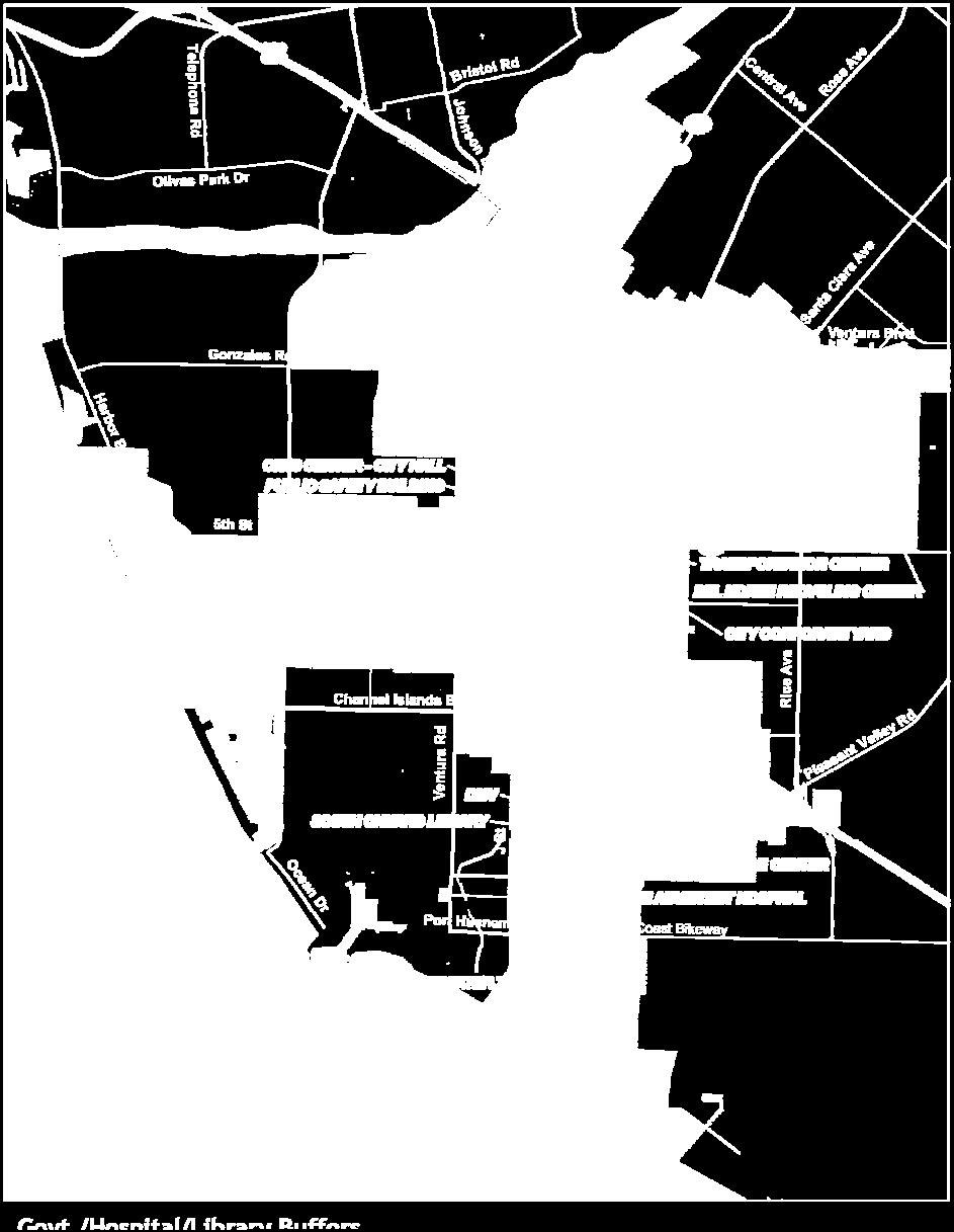
48 Chapter Four Needs Analysis Map 4-6: Government/Hospital/Library Buffers 38 Alta Planning + Design
49 City of Oxnard Bicycle and Pedestrian Master Plan Map 4-7: Bike and Pedestrian Attractors Model Alta Planning + Design 39
50 Chapter Four Needs Analysis Bicycle and Pedestrian Trip Generation The Demand Model uses 2000 Census population data to gauge the potential volume of bicyclists and pedestrians, based on how many people live or work within the activity areas identified in the first step of the model. Activity areas, with a greater number of people living or working, are more likely to have people walking and bicycling. Since census data are not collected in accordance to the model s grid, each cell is scored according to the population density of the census tract in which it is contained. Table 4-6 shows the scoring attached to population density. Map 4-8 shows population distribution within Oxnard. Table 4-6: Population Density and Scoring Population Density (Pop per Sq. Mile) Rank >16,000 very high 4 12,001 16,000 high 3 7,000 12,000 medium 2 <7,000 low 1 Score with Weighted Multiplier Bicycle and Pedestrian Detractors Detractors are features that are likely to discourage or detract people from walking or bicycling. The Demand Model includes the following detractors: places where collisions occur, road traffic volume (measured in Average Daily Trips ADT), and roadway speed limits. For the Demand Model, detractors are scored similarly to attractors. They are assigned a value; then they are weighted based on their frequency with a cell. Table 4-7 shows the scoring for various detractor types. Map 4-9 shows the resulting detractor map. Table 4-7: Scoring Bicycle and Pedestrian Detractors by Detractor Type Ranges Points Multiplier Final Score Collisions per Location Traffic Volume (ADT in 1000s of trips) Alta Planning + Design
51 City of Oxnard Bicycle and Pedestrian Master Plan 4.3 Collision Analysis Ranges Points Multiplier Final Score Speed by road type (MPH) The Oxnard Police Department keeps a database of collision data for motor vehicle collisions with bicyclists and pedestrians. The collision data employed in the model include all reported incidents for a five-year period. In total, between early 2004 and early 2009, Oxnard experienced 426 bicycle collisions and 432 pedestrian collisions Bicycle Collisions The majority of collisions happen at intersections during automobile turning movements. In Oxnard, 97% of bicycle collisions with motor vehicles occurred at intersections Arterials Over 64% of the recorded bicycle collisions occurred on arterials or highways, including Channel Islands Boulevard, 5th Street, Gonzales Road, H Street, J Street, Oxnard Boulevard, Pleasant Valley Road, Rose Avenue, Saviers Road, Ventura Road, Vineyard Avenue, and Wooley Road. These roads tend to have higher speed limits and larger volumes of traffic. Improvements may involve providing dedicated right of way to bicyclists, removal of travel lanes for streets wider than necessary given existing traffic volumes, provision of bicycle lanes to the left of right-turn pockets for through bicycle traffic, or installation of shared lane markings Minor Roads A notable number of bicycle collisions in Oxnard occurred on smaller residential and collector roads, including Bard Road, C Street, Camino Del Sol, Cooper Street, and Hemlock Street. Although these streets are smaller and less busy than arterials and highways, they are feeder streets that provide routes connecting through neighborhoods, which may explain why they might host more bicycle-automobile conflicts Bicycling Safety Rating The collision rate in Oxnard is 0.43 per 1,000 people per year. Table 4-8 shows that this is above the average California State collision rate. Parameter Table 4-8: Oxnard Bicycle Collisions Total number of bicycle collisions for 5 years 426 Average # of bicycle collisions per year 85.2 Average Bicycle Collision Rate per 1,000/year 0.43 Index (relative to statewide average of 0.32 /1000) 1.35 Number/Rate Alta Planning + Design 41
52 Chapter Four Needs Analysis Pedestrian Collisions Compared to bicycle collision data, pedestrian collisions were five times more likely to occur at mid-block locations. Still, the vast majority of pedestrian collisions (83%) occurred at, or near, intersections Mid-Block Collisions Closer examination reveals that the majority of mid-block incidents tend to be located on major roads, suggesting that they may result from pedestrians attempting to cross outside of designated crosswalks. Facility enhancements to prevent dangerous crossings include limiting mobility options for example, median barriers to inhibit pedestrians from attempting to cross and facilitating mobility options adding pedestrian controlled stop-lights and crosswalks that create safe crossing conditions Intersection Collisions A host of improvements can create safer pedestrian environments. Signal-timing can be lengthened to appropriately accommodate user needs. Proper assessment of traffic flow and road geometry may also be useful in identifying conditions that may encourage speeding; subsequent improvements like curb extensions, signage, and modified traffic control can collectively affect existing hazards Walking Safety Rating The collision rate in Oxnard is 0.44 per 1,000 people per year. Table 4-9 shows that this is below the average California State collision rate Other Barriers Table 4-9: Oxnard Pedestrian Collisions Parameter Number/Rate Total number of pedestrian collisions for 5 years 432 Average # of pedestrian collisions per year 86.4 Average Pedestrian Collision Rate per 1000/year 0.44 Index (relative to statewide average of /1000) 0.87 Network gaps can stem directly from other identifiable barriers, like the lack of through streets from highway, freeway, or railroad right of way; water bodies; topography; street network configurations, and disjointed jurisdictional control. In Oxnard, notable barriers include the following: US 101 separates the Riverpark & El Rio neighborhoods from the Financial Plaza, Esplanade, The Village and southwestern portions of town. State Route (SR)-1/Oxnard Boulevard presents numerous difficulties; the adjacent active railroad impedes crossings and through traffic, and it is currently outside the city s jurisdiction. The flood control channel running parallel between Saviers Road and Rose Avenue, south of Oxnard Boulevard, creates a natural east-west division to the east, College Estates and Terrace Estates, and to the west, the Blackstock neighborhoods and Pleasant Valley Estates; channel crossings only occur at major arterials, which are less accommodating to bicyclists and pedestrians. 42 Alta Planning + Design
53 City of Oxnard Bicycle and Pedestrian Master Plan A number of neighborhoods have closed street systems; while this is helpful for reducing through auto-traffic, lack of easements and throughways for pedestrians and bicyclists force them to use collector streets with automobiles. Some streets in Oxnard, that may require bicycle or pedestrian facility improvements, may be under state or county jurisdiction. Alta Planning + Design 43

54 Chapter Four Needs Analysis Map 4-8: Bike and Pedestrian Generators Model 44 Alta Planning + Design

55 City of Oxnard Bicycle and Pedestrian Master Plan Map 4-9: Bike and Pedestrian Detractors Model Alta Planning + Design 45
56 Chapter Four Needs Analysis Composite Value Conclusion Finally, the attractor, generator, and detractor grid cell points are overlaid on top of each into a single map. The cells contain each level of analysis to provide a total composite value. This value identifies areas that have both high potential for non-motorized activity, along with high detractors. The ranking of each cell is lumped into block groups and normalized by dividing the total composite score by the geographical area. This allows the comparison of communities based on a common denominator and identifies the communities with high densities of potential pedestrian and bicycling activity. Map 4-10 shows the final output of the Bicycle and Pedestrian Demand Model. 4.4 Additional Generator Considerations Community Involvement As part of the community involvement process, the consultant team reported to the City of Oxnard Planning Commission. In addition, the City s project manager met with residents, neighborhood councils and community bicycle advocates. Feedback from the public during these meetings was incorporated into the plan through city comments. Finally, the draft plan was open for public comment from September 22, 2011 through October 21, Comments were received and addressed from surrounding public agencies including; County of Ventura and Ventura County Watershed Protection District as well as residents New Developments in Specific Planning Areas The City of Oxnard has a number of planned residential, commercial, and industrial developments. Some are located in already built-out portions of the city; others are sited in previously undeveloped areas. In addition to solutions for barriers in the existing built environment, comprehensive bicycle and pedestrian networks must also accommodate projects in these areas. These specific planning areas include RiverPark, The Village, SouthShore, Sakioka, Teal Club, South Ormond Beach, and Las Brisas. 46 Alta Planning + Design


57 City of Oxnard Bicycle and Pedestrian Master Plan Map 4-10: Bike and Pedestrian Composite Model Alta Planning + Design 47
58 Chapter Four Needs Analysis This page intentionally left blank. 48 Alta Planning + Design
59 City of Oxnard Bicycle and Pedestrian Master Plan 5 Recommended Improvements The City requires solutions for both bicycling and walking. For bicycling, this primarily includes a one-half mile grid of bicycle facilities, targeting gaps, barriers and new developments. For walking, this includes identification of intersections and road segments that require improvement, ranging from the installation of sidewalks, signal re-timing or crosswalk implementation, to pedestrian bridges or traffic calming measures. This chapter presents the recommended improvements to Oxnard s bicycle and pedestrian networks. Recommended facilities connect to proposed facilities in the County of Ventura where possible. This Plan does not recommend any changes to the Oxnard City Code. 5.1 Bicycling Facilities The proposed bicycle network includes Class I, II and III improvements (i.e. multi-use paths, bike lanes, and bicycle boulevards and routes). City of Oxnard design standards for bicycle facility types is detailed in the plan s design guidelines located in Appendix A: Design Guidelines. The 2011 plan contains 30.5 miles of proposed Class I facilities, 40.7 miles of proposed Class II facilities, and 52.0 miles of proposed Class III facilities, which includes 13.9 miles of proposed bicycle routes and 38.1 miles of proposed bicycle boulevards. See Map 5-1 for a map of the proposed bicycle network Multi-Use Paths (Class I) Table 5-1 summarizes the proposed bicycle path improvements. Paths can offer connections where roads fail to connect. This is especially useful for Oxnard where neighborhood roads exhibit a closed network for auto traffic. Bicycle paths can also act as major arterials of connectivity. For example, four of the proposed paths combine to form a continuous north-south route through the city from the Santa Clara River in the north to the Pacific Ocean in the south. These four trails are (1) N. Ventura Rd-Wagon Wheel Rd path (2) Rail with Trail North path, (3) Rail with Trail South path, and (4) J Street Drain Path. City of Oxnard standards for bicycle lanes can be found in Appendix A: 1.2 Design of Multi-use Paths (Class I). A number of the proposed paths already exist for pedestrians. Further enhancement to accommodate bicyclists may involve right of way widening or striping for mode-separation. Additional proposed Class I facilities include bicycle and pedestrian bridges that will provide access across major barriers. For example, the Gary Drive Flood Channel Bridge will provide an improved direct connection for neighborhood residents to parks and schools across the flood control channel. Alta Planning + Design 49
60 Chapter Five Recommended Improvements Table 5-1: Proposed Multi-Use Paths Full Name From To Class Mileage 5th Street Harbor Blvd Victoria Ave I 1.2 5th Street Oxnard Blvd Del Norte Blvd I 2.7 Detroit Dr Connection Detroit Dr Forest Park Blvd I 0.1 Edison Canal* West of Harbor Blvd (at North City Limit) Harbor Blvd via Eastbourne Bay I 4.1 Holly Ave Rhonda St. N. H St. I 0.2 J Street Drain Path Hueneme Rd South City Limits I 0.6 N. Ventura Rd-Wagon Existing Class I (on N. Wheel Rd Ventura Rd) Oxnard Blvd at Esplanade Dr I 1.1 River Park Loops Santa Clara River Trail Santa Clara River Trail I 2.2 I-C1 (UPRR/Oxnard Blvd) Camino Del Sol Perkins Rd/J Street Canal I 5.3 I-C2 (UPRR/Oxnard Blvd) Village Development Martin Luther King Jr Dr I 1.5 Santa Clara River Trail East Victoria Ave Central Ave I 4.0 Santa Clara River Trail West* Harbor Blvd/Pacific Ocean Victoria Ave I 2.3 South Shore Rail with Trail South (loop via South Rail With Trail South Extension** Shore Dr and Olde Rd) I 2.7 Victoria Ave* Santa Clara River 5th Street I 2.5 TOTAL 30.5 *Includes facility outside of City limits **Provided the South Shore Specific Plan is adopted by City Council. 50 Alta Planning + Design
61 101 nt 65 er rk Av St Vin e Del Norte Blvd Rice Ave Rose Av 82 Beaumont Av Rose Av Anchorage St Paula St lle Va nt sa 71 Sanford St 13 Hueneme Rd Olde Rd Clara St 73 d yr 83 Plea 44 Gary Dr South Shore Dr Pleasant Valley Rd Class I - Multi-use path 48 Dollie St Cloyne Av J St Ventura Rd 72 San Simeon Av C St 39 Yucca St r 49 ny D Ln 37 Alba set Bryce Canyon Av Bard Rd 86 1 V U Hueneme Rd 28 Perkins Rd Existing Proposed San Mateo Pl 30 Channel Islands Bl 50 Surfs ide D r Rose Av Pacific Av 62 Rice Ave 16 Emerson Av Rice Ave Dupont St Laurel St 41 LEGEND Juanita Av Entrada Dr Oxnard Blvd C St G St 61 Statham Bl Ventura Rd M St Novato Dr Patterson Rd Offshore St Victoria Av Birch St Spruce St Sun 81 Pacific Ocean 8 Wooley Rd v 18 1 V U Hill St 12 Hemlock St 5 la Channel Islands Bl 11 Wooley Rd Hill St Fifth St 33 cia Rd 91 9th St er ch Bea 59 7th St 57 Eastman Av Fifth St mm lay 69 Wooley Rd 36 Co nda Ma 21 Sturgis Rd 54 Gisler Av l 4th St Fifth St 87 Camino Del Sol rd St C St rb rbo Ha 2 78 Camino Del Sol nd St 2 Oarfish Ln Ventura Bl Gonzales Rd 47 Cesar Chavez Dr Cooper Rd 74 5 Av Gonzales Rd 4 Fifth St r Dr Graves Av Cente Lockwood St 46 2 ra Bl 58 7 Doris Av Teal Club Rd Auto Ventu St Marys Dr 22 H St Ivywood Dr 15 Sa nt a Kentia St 1 U V Lantana St Ventura Rd Gallatin Pl Patterson Rd Dr Victoria Av e ad lan Gonzales Rd Doris Ave 85 Holly Av sp Ce nt ra la v 51 Dr.E Harbor Bl rd Av a Viney r Bl W ve ya rd ne Pa 90 Ri Av st ah on Cl ar a S Ce aw ar re To 84 Ki Ro se an G Fo wn ya rd 76 Vin e ra Av la ta C er iv R 77 Class II - Bicycle Lane Class III - Bicycle Route Class III - Bicycle Boulevard Surrounding Communities Network Pacific Coast Bikeway Route City Limit Parks Schools Transportation Center Oxnard Existing Prioritized andbicycle Proposed Projects Bicycle Facilities Oxnard, CA Bicycle & Pedestrian Master Plan Alta Planning + Design 51 Source: City of Oxnard Date: February 2012 I 0 Map 5-1: Oxnard Existing and Proposed Bicycle Facilities Miles City of Oxnard Bicycle and Pedestrian Master Plan Proposed Bridge
62 Chapter Five Recommended Improvements This page intentionally left blank. 52 Alta Planning + Design
63 City of Oxnard Bicycle and Pedestrian Master Plan Bicycle Lanes (Class II) The bicycle lanes listed in Table 5-2 have been proposed to complete the existing bicycle lane network within Oxnard. They are mostly located on arterials and collectors. City of Oxnard standards for bicycle lanes can be found in Appendix A: 1.3 Design of Bicycle Lanes (Class II). Table 5-2: Proposed Bicycle Lanes Full Name From To Class Mileage 2nd St Ventura Rd H St II 0.4 3rd St A St Rose Ave II 1.1 5th St K St H St II 0.2 5th St Mandalay Beach Rd. Harbor Blvd II 0.3 5th St Victoria Ave West to City Limit (ab west of Victoria Ave) II 0.3 Auto Center Dr Rose Ave Ventura Blvd II 0.1 C Street Channel Islands Blvd Pleasant Valley Rd II 1.3 Camino Del Sol Existing Bike Lanes (east of Oxnard Blvd) Oxnard Blvd II 0.2 Doris Ave Victoria Ave Ventura Rd II 1.5 Esplanade Dr Oxnard Blvd Vineyard Ave II 0.2 Gonzales Rd (east) N. C St Oxnard Blvd II 0.2 Gonzalez Rd* Victoria Ave Harbor Bl II 1.2 Gonzales-Rd (Sakioka Extension - Street A-Street B-Street C)** Rice Ave Del Norte Blvd II 2.7 Hemlock St Elsinore Ave Ventura Rd II 0.6 Hueneme Rd Surfside Dr* J St Hueneme Rd II 1.9 Hueneme Rd* Existing Bike Lanes (east of Southshore Dr) Olde Rd II 1 Hueneme Rd Existing Bike Lanes (east) Existing Bike Lanes (east of Arcturus Ave) II 0.3 Lockwood St Existing Bike Lanes (east of Rose) Rose Ave II 0.8 Olde Rd* Hueneme Rd Sanford St II 0.5 Oxnard Blvd Train tracks (north) Pleasant Valley Rd II 1.9 Oxnard Blvd Access-E. Channel Islands Blvd* E. Channel Island Blvd Rice Ave II 1 Patterson Rd 5th St Dunkirk Dr II 0.1 Patterson Rd* Doris Ave Teal Club Rd II 0.4 Patterson Rd W. Vineyard Ave Gonzales Rd II 0.6 Pleasant Valley Rd J St. Squires Dr II 0.9 Rice Ave Auto Center Dr Gonzales Rd II 0.4 Rice Ave* 5th St Hueneme Rd II 3.5 Alta Planning + Design 53
64 Chapter Five Recommended Improvements Full Name From To Class Mileage Rose Ave Camino Del Sol E 5th St. II 0.6 Rose Ave Bike lanes on Rose Ave (end of) Gonzales Rd II 0.2 Rose Ave* Auto Center Dr Los Angeles Ave II 3.3 Southshore Dr Loop* Hueneme Rd Olde Rd II 1.1 Sturgis Rd Lombard St 650 ft. West of Candelaria Rd II 0.1 Teal Club Rd Victoria Ave Ventura Rd II 1.5 Town Center Dr Oxnard Blvd RiverPark Blvd II 0.4 Ventura Blvd Santa Clara Ave Del Norte Blvd II 0.9 Ventura Rd Highway 101 Vineyard Ave II 1.0 Ventura Rd. Gonzales Rd Teal Club Rd/2nd Street II 1.1 Ventura Rd 5th St Teakwood St II 1.9 Victoria Ave* Gonzalez Rd Teal Club Rd II 1.1 Vineyard Ave City Limits north Oxnard Blvd II 1.8 Wooley Rd C St Saviers Rd II 0.2 Wooley Rd* Richmond Ave Rice Ave II 1.5 Wooley Rd Existing Bike Lanes east Harbor Blvd II 0.4 TOTAL 40.7 *Includes facility outside of City limits **Pending approval of the Sakioka Farms Specific Plan Bicycle Routes (Class III) Bicycle Routes are defined as facilities shared with motor vehicles. They are typically used on roads with low speeds and traffic volumes, however can be used on higher volume roads with wide outside lanes or with shoulders. Bicycle routes can employ a large variety of treatments from simple signage to complex treatments involving various types of traffic calming and/or pavement stenciling. Table 5-3 lists the proposed bicycle routes. The proposed bicycle route facilities would feature wide outside lanes, signage and/or pavement markings. City of Oxnard standards for bicycle lanes can be found in Appendix A: 1.4 Design of Bicycle Routes (Class III). Table 5-3: Proposed Bicycle Routes Full Name From To Class Mileage 2nd St H St C St III 0.4 5th St Meta St Del Norte Blvd III 2.9 4th St Meta St C Street III 0.3 Arcturus Ave-Cypress Rd-Cloyne St (through Johnson Creek Park)-Gisler Ave- Date St-Pine St-Commercial Ave- Hueneme Rd 4th St III 3.9 Meta St C St Magnolia Kamala St III Alta Planning + Design
65 City of Oxnard Bicycle and Pedestrian Master Plan Full Name From To Class Mileage Camino Ave Del Norte Blvd City Limits (east) III 0.4 Channel Islands Blvd Ventura Rd Existing Bike Lanes (east of Paula St) III 1.5 Dodge Road* Pleasant Valley Rd Rainbow Dr III 0.4 Hemlock St Patterson Ave Elsinore Ave III 0.1 Pleasant Valley Rd* Oxnard Blvd Dodge Rd III 0.5 Ventura Blvd E Vineyard N. Rose Ave III 1.2 Wooley Rd Saviers Rd Richmond Ave III 0.5 TOTAL Bicycle Boulevards (Class III) Table 5-4 lists the proposed bicycle boulevards. Bicycle boulevards are generally installed on minor or local roadways and feature both lane markings and traffic calming measures. The alignment for bicycle boulevards is meant to facilitate bicycling on roads with slower and or fewer cars, and on connections through residential areas. City of Oxnard standards for bicycle lanes can be found in Appendix A: Bicycle Boulevards. Table 5-4: Proposed Bicycle Boulevards Full Name From To Class Mileage Albany Dr E. Channel Island Blvd Gary Pl III 0.4 Birch St-California St C St Date St. III 0.6 Boston Dr-Jason Pl-Anchorage St- Berkshire St-Terrace Ave Gary Dr. Pleasant Valley Rd. III 1.0 Bryce Canyon Ave J St. Saviers Rd III 0.5 Bryce Canyon Ave-Thomas Ave Saviers Rd Cloyne St. III 0.3 C Street Gonzales Rd Magnolia Ave III 1.0 C Street Pleasant Valley Rd Hueneme Rd III 0.5 Cesar Chavez Dr.-Gilbralter St -Milagro Pl- Kohala St-Latigo Ave Juanita Ave N. Rice Ave III 1.6 Clara St. J St. Cypress Rd. III 0.8 Colonia Ave-Sycamore St-Detroit Dr (through parkway/class I) - Thames River Rd RiverPark Blvd Indus Pl III 0.7 Oxnard Blvd Dupont St-Ives Pl-Carnegie Ct-San Mateo Emerson Ave Access/Channel Islands Pl-Dupont St Blvd III 0.7 Edelweiss Ave-through Orchard Park- Ilex W. Vineyard Ave Gonzales Rd III 0.7 Alta Planning + Design 55
66 Chapter Five Recommended Improvements Full Name From To Class Mileage Dr- Carnation-Fauna Dr-C St. Emerson Ave Rose Ave Dupont St III 0.3 Entrada Dr-Garfield Ave E. Gonzales Rd Cooper Rd III 1.2 Falkirk Ave (via S Harbor Service Bl) - Harbor Mandalay Beach Rd Blvd/Eastbourne Bay Sunset Lane III 0.7 G St/Hemlock St W. Wooley Rd Ventura Rd III 1.0 Gary Dr Albany Dr N. Rose Ave III 0.4 Guava Street G St C St III 0.3 Harbor Blvd Sunset Ln Ocean Dr III 0.2 Hill St Novato Dr C St III 1.4 Holly Ave Ironbark Dr. N. H St. III 0.1 Holly Ave. Rhonda St. Lantana St. III 0.5 Keel Ave-Kelp St-Jacktar Ave-Jetty St Offshore St. W. Hemlock St III 0.5 La Canada Ave - Sam Simeon Ave Cloyne St. Bard Rd. III 0.7 Laurel St C St Gisler Ave III 0.5 M St. Hemlock St Spruce St. III 0.6 Magnolia Ave-A St-Cooper Rd N. C St. S. Juanita Ave. III 0.8 Mandalay Beach Rd W. 5th St. Beach Way III 1.2 Moss Landing Blvd Garonne St Oxnard Blvd III 0.3 N. Vineyard Ave-St Marys Dr-Princeton Ave-Rio Lindo St W Vineyard Ave Snow Ave III 0.9 Novato Dr-Hill St-McLoughlin Ave Kite Dr Hemlock St III 1.1 Oarfish Ln (via Peir Walk & Pilot Way) Victoria Ave OffShore St III 0.6 Oarfish Ln-Stern Ln Offshore St Novato III 0.6 Offshore St- Ketch Av- Capstan Dr. Oarfish Ln Hemlock St III 1.0 Outlet Center Dr Lockwood St Gonzales Rd III 0.2 Paula St-Tamarac St-Fournier St Channel Islands Blvd La Canada Ave III 0.4 Rhonda St-Bevra Ave-Spyglass Trail East- Gallatin Pl-Oneida Pl-Coronado Pl Holly Ave Doris Ave III 1.5 River Ridge Rd-Kapalua Dr-Princeville Ln W. Vineyard Ave Holly Ave III 0.3 Rosa St B St- Dollie St. C St. Cloyne St. III 0.5 Rose Ave-Sanford St-Peoria Av -Tulsa Dr- Sanford St-Beaumont Ave Pleasant Valley Rd. Pleasant Valley Rd. III 1.2 San Mateo Pl-El Dorado Ave Carnegie St E. Channel Island Blvd III 0.6 Snow Ave-Torero Dr-Limonero Pl-Martin Luther King Jr Dr-Juanita Rio Lindo St. E. 3rd St. III 1.8 Spruce St.(east) J St. S. C St. III 0.3 Spruce St.(west) N. Ventura Rd. J St. III 0.5 Statham Blvd Pacific Ave Channel Islands Blvd III 0.5 Sunset Ln Mandalay Beach Rd. Harbor Blvd III Alta Planning + Design
67 City of Oxnard Bicycle and Pedestrian Master Plan Full Name From To Class Mileage Talus St-Ebony Dr-Cabrillo Way-Gina Dr- Ivywood Dr N. Patterson Rd. N. C St III 1.6 Upper Bay Dr-Huneysuckle Dr-H St-Violet Way Kentia St Grapevine Dr III 0.3 Van Ness Ave J St. C St III 0.3 Ventura Rd-Kiawah River Dr Garonne St Oxnard Blvd III 0.4 Yearling Pl-Kentia St-Indigo Pl-Lantana St- Lodgewood Way-Lakehurst Honeysuckle Dr Glenwood Dr III 1.9 Yucca St San Simeon Ave J St III 1.1 TOTAL Bicycle Parking Support facilities are essential components of a bicycle system because they enhance safety and convenience for bicyclists at the end of every trip. With nearly all utilitarian and many recreational bike trips, bicyclists need secure and well-located bicycle parking. A comprehensive bicycle parking strategy is one of the most important things that a jurisdiction can apply to immediately enhance the bicycling environment. The City of Oxnard should continue to provide short-term bicycle parking in the form of bicycle racks at all major trip attractors, including commercial and civic activity centers and transit hubs, and ensure that an adequate supply is available. The City should prioritize the installation of bicycle parking throughout the city, with particular attention directed at the following locations: Parks Schools Commercial/office areas Civic/government buildings Public transit stations High-activity locations such as transit stations, offices, and major commercial districts should consider providing more secure, long-term bicycle parking options, such as bicycle lockers. Any future transit hubs and intermodal facilities could include secure bicycle parking areas as part of their design. Secure bicycle parking areas that provide services, such as bicycle rentals and repair, could be considered at major transit stations and commuter destinations. Oxnard should also consider providing facilities for changing and storing clothes and bicycle equipment. Amenities such as lockers and showers can increase bicycle facility use, especially among active professionals Bridges Bridges provide improvements for increased bicycle access across barriers. The proposed bridges would accommodate all non-motorized transportation modes, diverting them from busy arterials and providing safe and convenient connections. Bridges proposed as part of this plan are the Gary Place bridge, the 5 th Street bridge, and the bridge from the South Bank Neighborhood over the railroad to the proposed Transit Village Alta Planning + Design 57
68 Chapter Five Recommended Improvements Center. Widening 5th Street to accommodate travel lanes, sidewalks, and bike lanes could be an alternative to a pedestrian bridge. 5.2 Pedestrian Facilities Pedestrian-oriented improvements were identified through a two-step process. The needs analysis model provided a high level survey of city-wide pedestrian activity. City staff worked closely with the consultant team to determine pedestrian areas that lacked facilities such as sidewalks or posed safety concerns. Improvements were categorized into corridors, intersections, and pedestrian bridges. Map 5-2 illustrates where these improvements are located and Table 5-5 defines in detail the specific location of recommended improvements Corridor Improvements Corridor improvements are important because they enhance mobility and aid in a city s compliance with the American Disabilities Act (ADA). City-level policies can also mandate the implementation of corridor facilities in new development that exceed ADA compliance. Mobility enhancements on corridors include installing new sidewalks, replacing or upgrading older sidewalks, and putting in crossings to help pedestrians reach their destinations Intersection Improvements Intersection improvements are also necessary to enhance mobility and comply with ADA. Upgrading intersections increases the connectivity of the pedestrian network by linking corridors. Intersection enhancements include truncated domes at intersection crosswalks, audible crossing signals, countdown timer signals, pedestrian refuge islands, and curb ramps for wheelchair access Bridges Bridges provide improvements for increased pedestrian access across specific barriers such as railroads. The proposed bridges would accommodate all non-motorized transportation modes, diverting them from busy arterials and providing safe and convenient connections. Table 5-5: List of Proposed Pedestrian Facilities Corridors Full Name From To Mileage Cooper Rd Hayes Ave Juanita Ave 0.33 Oxnard Blvd South of Vineyard Oxnard Service Rd Oxnard Blvd Gonzales Rd A St 0.40 Oxnard Blvd Orchard Pl 101 Overpass 0.65 Rose Ave Oxnard Blvd Ives Blvd 0.24 Saviers Rd Bard Rd Yucca 0.34 Saviers Rd Bard Rd Pleasant Valley Rd 0.4 Saviers Rd Elm Street 4th Street 1.1 Ventura Blvd Vineyard Ave Rose Ave 1.0 Victoria Ave Gonzalez Rd 5th St Alta Planning + Design
69 City of Oxnard Bicycle and Pedestrian Master Plan Corridors Full Name From To Mileage TOTAL 5.43 Intersections Street 1 Street 2 Street 3 A St Deodar A St Roderick Channel Islands Blvd Merced El Dorado Channel Islands Blvd Olds Juanita Ave 1st St Oxnard Blvd Channel Islands Blvd Rose Ave Saviers Rd Hill (north) Saviers Rd Clara Bridges Gary Pl Bridge 5 th St Bridge over Channel South Bank Neighborhood over railroad to Proposed Village Transit Center. *Widening 5 th Street to accommodate travel lanes, sidewalks, and bike lanes is an alternative to a pedestrian bridge Alta Planning + Design 59

70 Chapter Five Recommended Improvements 60 Alta Planning + Design Map 5-2: Oxnard Proposed Pedestrian Improvement Areas
71 City of Oxnard Bicycle and Pedestrian Master Plan 5.3 Existing Bicycle Lane Enhancements As part of the scope of work of this plan, MNS Engineers conducted a review of existing bike lanes in the City of Oxnard to identify areas where facility upgrades could be made to enhance the safety or functionality of the facility. In addition, staff from the City of Oxnard participated in bike audits of the existing bike lanes and made recommendations based on the proposed bike lane standards Methodology The safety review conducted included the following elements: A review of all of the existing bike lanes for compliance with the proposed bike lane standards outlined in Appendix C; Recommend modifications with generalized cross sections (if any are required); Discussion of bike lane options at intersections; Planning level cost estimates for any recommended changes Results MNS Engineers recorded 106 miles of bike lanes and intersection enhancement recommendations. The estimated cost for the improvements is approximately $4.2 million. Enhancements identified include striping bike lanes to close gaps, delineating parking areas, adding Bike Lane stencils, removing on-street parking, and widening bike lanes. Map 5-3 depicts the areas in need of improvement. See Appendix C: Safety Review for the detailed list of improvements needed and itemized cost estimates. Alta Planning + Design 61


72 Chapter Five Recommended Improvements Map 5-3: Existing Bike Lane Enhancement Corridors 62 Alta Planning + Design


73 City of Oxnard Bicycle and Pedestrian Master Plan 5.4 Recommended Policies and Programs This section contains recommended enforcement, education and awareness policies and programs for Oxnard. Creating a city that supports and encourages its residents to bicycle and walk involves more than just infrastructure and amenity improvements Enforcement Policies and Programs Motorists, pedestrians and bicyclists alike can be unaware of each other s rights as they travel. Educating the public through enforcement policies will supplement the physical improvements made in Oxnard. Targeted enforcement action should be focused in areas with high bicycle and pedestrian volumes or where non-motorized traffic is particularly high (e.g., Downtown Oxnard, Mandalay Beach Path, and Oxnard Transportation Center). Law enforcement efforts should be targeted at locations where motorists and the general public will become aware of bicycle/pedestrian laws and their penalties. It is recommended that such targeted enforcement occur at least four times per year and last one week. Focused enforcement should also take place at the start of the school year at selected schools near their primary access points by walking and bicycling children. Police visibility encourages safe behavior. Coordination between the Oxnard Police Department and City staff will ensure that enforcement activities are conducted at strategic locations and where public feedback warrants focused efforts. The Oxnard Police Department should also be surveyed for input on appropriate educational material, advisory and warning signs, and other tools to help them accomplish their mission. Pedestrians and bicyclists are protected in the public right-of-way by the California Vehicle Code, as enforced by the Oxnard Police Department. For a review of Oxnard City Ordinances affecting bicyclists and pedestrians, please refer to Table Bicycle Patrol Unit Oxnard may want to work with its Police Department and with local businesses and neighborhood groups to establish additional local Bicycle Patrol Units. The city s size and topography make many parts of it highly accessible by bicycle. A Bicycle Patrol Unit may be an official law enforcement unit, a private security guard patrol, or a volunteer network. Bicycles are an excellent community-policing tool, as officers on bikes are often viewed as more approachable, thus improving trust and relations between the citizens and police. Bicycle Patrol Units police areas of the community accessible by bicycle. Alta Planning + Design 63

74 Chapter Five Recommended Improvements Bicycle patrol units can work closely with citizens to address concerns before they become problems. Bicycle patrol units can have a direct impact on bicycle and pedestrian safety by enforcing bicycle traffic laws (e.g., wrong-way riding, sidewalk riding, obeying traffic controls, children wearing helmets etc.), enforcing pedestrian laws (e.g. use of crosswalks, obeying pedestrian countdown signals, etc.) and providing bicycle and pedestrian safety education. Additional resources for a police education course can be found at: Speed Limit Enforcement City staff can work with police to enforce speed limits on designated bikeways near schools and in response to cyclist/pedestrian complaints. This increases safety and reduces crashes, which decreases barriers to walking and bicycling Speed Radar Trailer Speed radar trailers can be used to reduce speeds and enforce speed limit violations in areas with speeding problems. In these areas, police set up an unmanned trailer that displays the speed of approaching motorists along with a speed limit sign. Speed trailers may be effective on busier arterial roads where bikeway facilities currently do not exist or near schools were speeding has been reported. Speed trailers may be used as both an educational and an enforcement tool. By Speed trailer in use. itself, the unmanned trailer serves as effective education to motorists about their current speed in relation to the speed limit. As an alternative enforcement measure, the Oxnard Police Department may choose to station an officer near the trailer to issue citations to motorists exceeding the speed limit. Because they can be easily moved, radar trailers are often brought to streets where local residents have complained about speeding problems. If frequently left in the same location without officer presence, motorists may learn that speeding in that location will not result in a citation and increase their speeds. City staff may provide the management role for this program to work with the public and determine which locations are in most need. Because of the portability of speed trailers, this program can be used at random, cyclically, or as demand/public opinion necessitates Education Policies and Programs City staff can complement bicycle and pedestrian facilities with effective education programs and policies to promote biking and walking. Education programs ensure that bicyclists, pedestrians and motorists know how to travel safely and understand the regulations that govern these modes of transportation. They also increase the public awareness of bicycling and walking as means of transportation and increase public support for policies that promote safe walking and biking. 64 Alta Planning + Design

75 City of Oxnard Bicycle and Pedestrian Master Plan Share the Road Campaign A Share the Road campaign is intended to educate motorists, bicyclists and pedestrians about their legal rights and responsibilities on the road, and the need to increase courtesy and cooperation to improve safety. The campaign targets not just youth, but all residents and visitors to a community. The Oxnard Police Department, the Ventura County Bicycle Coalition and other partners should work together to develop a Share the Road Campaign. To establish a Share the Road campaign, the city should: Develop Share the Road flyers, one targeting bicyclists and pedestrians and one targeting motorists, which outline safe and courteous behavior, collision reporting procedures and local bicycling resources and hotlines. Bicycle Safety Class. Hold periodic traffic checkpoints during months with high bicycling and walking rates. At checkpoints, motorists, bicyclists and pedestrians are stopped, given a Share the Road flyer and have the opportunity to provide feedback to officers regarding the campaign ideas. Checkpoints could be held along local bikeways such as the Ventura Rd Bicycle Path. Create public service announcements on radio and TV to promote the Share the Road campaign, including publicity about the Share the Road checkpoints. Promote the campaign on the City s website. Develop public PowerPoint presentations with the Share the Road message for presentation to the public. Develop adult bicycle safety classes to teach how to properly share the road and hold them at regular intervals. Develop driver education classes to teach motorists how to share the road with bicyclists and hold them at regular intervals Continue and Expand Bicycle and Pedestrian Education Programs The City should continue and expand bicycle and pedestrian education programs through the existing Safe Routes to School program. The City s role in the Safe Routes to School process is to provide resources to support school-based Safe Routes to School stakeholder teams and to provide assistance in funding, construction, and program implementation. An effective Safe Routes to School will require technical support and implementation assistance from Oxnard s Public Works Department, Planning Department, and Police Department. Public Works and Planning personnel trained in engineering, traffic management and innovative bicycle and pedestrian treatments and programs can work with schools to determine the best way to improve school area bicycle and pedestrian safety. Alta Planning + Design 65
76 Chapter Five Recommended Improvements To help identify locations to improve bicycling and walking around schools and determine where to implement educational programs, the City should work with each school to collect the information presented in Table 5-6. Information Walking and biking conditions around school Traffic conditions around school Drop-off/pick-up conditions High-priority issues School signage and pavement marking conditions Number of children who walk or bike to school Attitudes toward biking and walking to school Barriers to biking and walking to school School policies that encourage or hinder biking and walking to school Table 5-6: Safe Routes to School Information Gathering Ways to Gather Mapping Walkabouts with parents, teachers, bicycle and pedestrian engineers Traffic counts Speed monitoring Observations during drop-off and pickup Public stakeholder meetings Parent surveys Sign inventory conducted with the assistance of a traffic engineer to ensure signage meets state MUTCD standards Student surveys Parent surveys In-classroom surveys/ hand counts Student surveys Parent surveys In-classroom surveys Student surveys Parent surveys Walkabouts Meetings with teachers, school officials and school district officials To complement the City s current Safe Routes to School programs, Oxnard should consider developing an educational program for bicyclists and pedestrians and working with the school districts to incorporate this type of safety class into the school curriculum. Typical school-based bicycle and pedestrian education programs educate students about the rules of the road, proper use of bicycle equipment, biking skills, street crossing skills, and the benefits of biking and walking. These types of education programs are usually sponsored by a joint City/school district committee that includes appointed parents, teachers, student representatives, administrators, police, active bicyclists and engineering department staff. Classroom educational materials should be presented in a variety of formats (safety videos, printed materials, and classroom activities), and should continually be updated to make use of the most recent educational tools available. Classroom education programs should also be expanded to promote the health and environmental benefits of bicycling and walking. Outside schools, educational materials should be developed for different audiences, including elected officials (describing the benefits of and need for a SR2S program), parents (proper school drop-off procedures, obeying speed limits near school, yielding to bicyclists and pedestrians and safety for their children) and neighbors (keeping pedestrian ways clear, obeying speed limits, yielding to 66 Alta Planning + Design
77 City of Oxnard Bicycle and Pedestrian Master Plan bicyclists and pedestrians). Educational programs should be linked with events and incentive programs when appropriate, and students should be included in task force activities, such as mapping locations for improvements. The City may want to consider working with local bicycle advocacy groups, as well as the School Districts, to develop a standard safety handbook and make it available to each school in a digital format for customization. Education need not be limited to younger children. Oxnard should also offer bicycle safety classes for adults, such as those that teach how to share the road as mentioned above. The City may consider working with the Oxnard Police Department to utilize adult bicycle and pedestrian education programs such as a bicycle/pedestrian traffic school in lieu of fines for bicycle or pedestrian-related traffic violations. These courses could be geared toward motorists as well, for drivers involved in collisions with bicyclists or pedestrians Provide Safety Handbook Safety handbooks are generally developed as part of a school-based bicycle and pedestrian safety program. Handbooks and educational programs for adults are also available from the League of American Bicyclists, and bicycle coalitions around the country. Handbooks may include a circulation map of the campus and immediate neighborhood showing the preferred circulation and parking patterns, suggested routes to school, locations of crosswalks, crossing guards and signalized intersections, instructions for bicycle maintenance and use, instructions for fitting and wearing a helmet, instructions for crossing the street, use of hand signals, rules of the road, city ordinances regulating bicycling, and lists of emergency and school numbers. A general handbook can be published by the City and used by each school in conjunction with the school-specific map Educate Motorists, City Staff, Maintenance and Construction Crews Bicycle and pedestrian related education should be targeted towards motorists, City staff, developers and others who directly or indirectly affect the biking and walking environment. Information regarding the rights of bicyclists and pedestrians and the rules of the road are especially important. As an example of a common misconception due to lack of education, many motorists mistakenly believe that bicyclists do not have a right to ride in travel lanes or that bicyclists should only ride on sidewalks. This is something that can be prevented or remedied with education about the rights and responsibilities of pedestrians and bicyclists. This education may include: Incorporating bicycle and pedestrian safety into traffic school curriculum; Producing a brochure on bicycle and pedestrian safety and laws for public distribution; Enforcing traffic laws for bicyclists; Providing training in bicycle and pedestrian planning for all City planners; Working with contractors, subcontractors, and City maintenance and utility crews to ensure they understand the needs of bicyclists and pedestrians and follow standard procedures when working on or adjacent to roadways and walkways Create a Multi-Modal Access Guide A multi-modal access guide provides concise customized information on how to access specific destinations with emphasis on biking, walking, and public transit. Access guides can be as simple as a map printed on the Alta Planning + Design 67

78 Chapter Five Recommended Improvements back of a business card or as complex as a multi-page packet distributed to employees. Some items commonly included in access guides are: A map of the area with rail and bus stops, recommended walking and biking routes, nearby landmarks, facilities such as restrooms and drinking fountains, locations of bicycle and vehicle parking and major roads. Information on transit service including: frequency, fares, accepted methods of payment, first and last runs, schedules, phone numbers and websites of transit service providers and taxis. Information on how long it takes to walk or bike from a transit station to a destination. Accessibility information for people with disabilities. Best practices include using graphics, providing specific step-by-step travel directions, providing parking locations and pricing information, and providing information about the benefits of walking and biking. Highquality access guides should be concise, accurate, and incorporate input from key stakeholders, including public transportation operators, public officials, employees, staff who will be distributing the access guide, and those with disabilities. Access guides are usually developed by facility managers, employers, or Transportation Management Associations System Identification (Wayfinding) System identification creates greater awareness of the bicycle and pedestrian network and provides wayfinding assistance for cyclists and walkers. System identification usually begins with the identification of a series of bicycle and pedestrian routes, development of a unique logo and facility signage, and development of a network map. Signage may also include informational kiosks, directional signage pointing out destinations, and mileage indicators. System identification plans are usually implemented and maintained by the City. The City should begin its system identification on its high priority projects (see Chapter 6). Development of a user map can be an excellent way to identify and publicize key routes throughout the City. Example trailhead marker on the Santa Clara River Trail in the City of Santa Clarita Bike Light Campaign California Vehicle Code (CVC 21201) requires bicycles to be mounted with a front white light and red rear reflectors. Bicycle lights are more visible than reflectors, enhancing the visibility of bicyclists while riding at night. To promote cooperation with the CVC and increase safe riding habits, a Bike Light campaign could be conducted in Oxnard. Portland, Oregon developed a See and Be Seen public safety campaign to encourage bicyclists to use lights and to remind motorists to watch for bikes. Campaign elements included coupons for bike lights and other reflective gear and a parade to celebrate bright bikes. More information on Portland s program is available at: 68 Alta Planning + Design
79 City of Oxnard Bicycle and Pedestrian Master Plan Encouragement Programs Strategies for community involvement in bicycle and pedestrian improvements will be important to ensure broad-based support to help secure financial resources. Involvement by the private sector in raising awareness of the benefits of bicycling can range from small incremental activities by non-profit groups, to efforts by the largest employers in the City. Specific programs are described below Facilitate the Development of Employer Incentive Programs Facilitate employer incentive programs to encourage employees to try bicycling and walking to work by including such strategies as supplying bicycle lockers and shower facilities, educate employers about California parking cash out program, offering more flexible arrival & departure times, and providing fun incentives such as entry into monthly raffle contests. The City may offer incentives to employers to institute these improvements through air quality credits, lowered parking requirements, reduced traffic mitigation fees, or other means Event Bicycle Parking Providing safe and secure bicycle parking helps encourage individuals to bicycle. The City of Oxnard may consider temporary bicycle parking or bike valet for events with expected large attendance and at regularly occurring events like a farmers market. Oxnard could partner with the Ventura County Bicycle Coalition to offer secure, professional, and attended bike valet services at City and private events Community Bikeway/Walkway Adoption Community Bikeway/Walkway Adoption programs are similar to the widely instituted Adopt-a-Highway programs throughout the country. These programs identify local individuals, organizations, or businesses that would be interested in adopting a bikeway/walkway. Adopting a bikeway/walkway would mean that person or group would be responsible for maintenance of the bikeway/walkway either through direct action or as the source of funding for the City s maintenance of that bikeway/walkway. For example, members of a local recreation group may volunteer every other weekend to sweep a bikeway/walkway and identify and address larger maintenance needs. Alternatively, a local bike shop may adopt a bikeway by providing funding for the maintenance costs. The managers of an adopted bikeway/walkway may be allowed to post their name on bikeway/walkway signs throughout the bikeway/walkway in order to display their commitment to bicycling and/or walking in Oxnard Work with Businesses to Develop Incentives for Biking and Walking Incentive programs to encourage biking and walking to local businesses can be developed in coordination with individual businesses, the Chamber of Commerce, the Ventura County Bicycle Coalition and Channel Islands Bicycle Club. Such efforts may include: Creating promotional events such as Bicycle to the Grocery Store days, when bicyclists get vouchers for, or discounts on items in the store, or Bicycle to the Video Store days, when bicyclists receive free popcorn or a discount on a movie rental. Holding an annual community event to encourage residents to replace one car trip a week with a bicycle trip. Alta Planning + Design 69


80 Chapter Five Recommended Improvements Developing, promoting and publicizing bicycle commuter services, such as bike shops selling commute gear, bike-on-transit policies, and regular escorted commute rides. Creating an annual commuter challenge for area businesses. Encouraging and facilitating the development of small satellite business services near bicycle trailheads such as mobile cafes and stands that sell amenities such as snacks, sunscreen, Band-Aids, and trail maps. Potential locations include the Santa Clara River Trail and the trail along the Edison Canal. Encouraging and facilitating the development of lunchtime amenities, such as outdoor lunch areas and satellite or mobile food stations in the Industrial Center Commit to Becoming a Recognized Bicycle Friendly Community The League of American Bicyclists sponsors an awards program that recognizes cities and counties that actively support bicycling. According to the League, a Bicycle Friendly Community is one that provides safe accommodation for cycling and encourages its residents to bike for transportation and recreation. The League recognizes four tiers of bicycle friendly communities: bronze, silver, gold and platinum. The City of Oxnard should develop an action plan to meet the League of American Cyclist s requirements to become a Bicycle Friendly Oxnard is eligible to apply for the national Bicycle Friendly Community award program. Community. The application process for being considered as a Bicycle Friendly Community involves an audit of the engineering, education, encouragement, enforcement, evaluation and planning efforts for bicycling. The League reviews the application and solicits feedback from bicyclists in the community to determine if Bicycle Friendly Status should be awarded. The League provides technical assistance and other information for cities working toward Bicycle Friendly Community status at: Develop Walking/Biking School Bus If parents are uncomfortable allowing their children to walk or bicycle alone to or from school, parent or neighborhood volunteers can escort a group of children walking or bicycling to school together in a Walking School Bus or Bike Train. Children can be picked up at home along the route, or at designated staging areas. The parents offer a level of supervision and protection and the larger numbers allow the children to be more visible to traffic. Usually, one parent acts as the organizer, recruiting other parents, neighbors, seniors or community volunteers to walk or bicycle with the children. As in a carpool, the participants need to work out schedules and meeting places. Adults and children can wear safety vests or use other means to enhance visibility. Sometimes the adult pulls a wagon to carry the children s books and projects. Children participating in a walking/biking school bus. 70 Alta Planning + Design
81 City of Oxnard Bicycle and Pedestrian Master Plan Bike-to-Health Campaign The City of Oxnard aims to support healthier lifestyles by encouraging and enabling bicycling and walking. Obesity and sedentary lifestyles are on the rise for both adults and children in America, and one way to combat this is to integrate daily exercise into American lifestyles. A Bike-to-Health marketing campaign may include the following: A website used as a central location for information on getting started, events, advice from health professionals, and safety information for adults and children; Print ads in community newspapers to increase the exposure of the campaign; Promotion of the campaign through community events and rides. These rides occur during the summer and early fall months. Participants earn prizes and attain better health through reaching mileage goals. Families are encouraged to participate and bike to better health together Ciclovias/ Sunday Streets First implemented in Bogota, Colombia, the Ciclovia is a community event based around a temporary street closure. Ciclovias provide local recreational and business opportunities for the community and are increasingly popular citywide events. Ciclovias can combine with other popular community events to promote walking and bicycling as a form of viable transportation. Ideally, Ciclovias should provide access to civic, cultural, or commercial destinations. The City of Los Angeles has hosted three ciclovias, called CicLAvia, since October At all CicLAvia events, routes went through downtown Los Angeles. The City could develop a ciclovia in Oxnard as an opportunity to highlight some of the new bikeways once constructed. 6 6 More information is available at Alta Planning + Design 71
82 Chapter Five Recommended Improvements This page intentionally left blank. 72 Alta Planning + Design
83 City of Oxnard Bicycle and Pedestrian Master Plan 6 Prioritization Strategy This section provides the methodology for prioritizing bicycle and pedestrian projects in the City of Oxnard. Prioritizing these projects will allow Oxnard to identify high priority projects and provide a foundation for implementation phasing. The prioritization framework builds upon the outcomes of the Needs Analysis Model from the Need Analysis in Chapter 4. Though project prioritization is meant to be a guideline for the City in the implementation phase of this plan, Oxnard can implement proposed projects outside of the prioritized ordering when appropriate. For example, striping lower priority bike lanes may be combined with street resurfacing projects to reduce costs. 6.1 Project Selection Criteria and Ranking The criteria used to rank the bicycle and pedestrian projects are discussed below. System Gaps and Connectivity to Existing Facilities Facilities that fill gaps among existing facilities (especially gaps that discourage walking/biking because they limit route continuity) qualify for this priority criterion. Attractors Model Results The attractors model identifies popular activity areas in Oxnard. Areas of activity such as transit centers, shopping centers, commercial and industrial centers, recreation areas, schools, libraries, hospitals and government buildings are the major trip-driving destinations within Oxnard. By increasing bicycle and pedestrian accessibility to major Activity Centers, the City of Oxnard Bicycle & Pedestrian Master Plan can reduce traffic congestion and support Oxnard residents and visitors who choose to bicycle or walk for transportation. Projects located within the most popular activity areas qualify for this prioritization criterion. Generators Model Results Population density is used to gauge the potential volume of bicyclists and pedestrians. Projects located within the most dense activity areas fit this priority criterion. Detractors Model Results The detractors model identifies the areas in Oxnard that are likely to discourage or detract people from walking or bicycling. Proposed facilities that can reduce the frequency of bicycle/pedestrian and vehicle collisions by serving areas with high volumes of such occurrences fit this priority criterion. City Input Projects with City input are those that have been previously considered by the City as desirable. Per the scope of this project, the Plan did not include an existing sidewalk survey, and therefore was more difficult to model. To address this, the City provided input based on project readiness and synergy of development in the vicinity. This criterion applies only to pedestrian projects. Each of the five criteria contains elements of a project s value to the bicycle and pedestrian network. Ranking the criteria establishes which factors have greater influence over prioritization. Each criterion was ranked and then given a weight according to the rank. Table 6-1 defines the rank and weight for each criterion. Alta Planning + Design 73
84 Chapter Six Prioritization Strategy Table 6-1: Criteria Rank and Weight Rank Criteria Weight 1 System Gaps & Connectivity to Existing Facilities 3 2 Attractors 3 3 Generators 2 4 Detractors 2 5 City Input (Pedestrian Only) 1 Each pedestrian and bicycle facility was grouped into a project area and analyzed under the five criteria and scored based upon their compliance with the ranking priorities. The following pages contain a breakdown of the scoring weights, as well as the complete pedestrian and bicycle project prioritization, sorted from highest scoring projects to the lowest. Criteria Score Multiplier Table 6-2: Bicycle Criteria Scoring Description Connectivity Attractors: -Transit -Shopping Centers -Commercial Centers -Recreation -Schools, Libraries, Hospitals & Government Generators Detractors: -Collisions -High Speeds -High Traffic Volume Total Possible Score Description Directly connects to more than one existing bicycle facility Directly connects to at least one existing bicycle facility Does not connect any existing bicycle facility Located in an area of high demand according to the attractors model Located in an area of medium demand according to the attractors model Located in an area of low demand according to the attractors model Located in an area of very high demand according to the generators model Located in an area of high demand according to the generators model Located in an area of medium to low demand according to the generators model Located in an area with many detractors to bicycle activity Located in an area with moderate detractors to bicycle activity Located in an area with few detractors to bicycle activity 74 Alta Planning + Design
85 City of Oxnard Bicycle and Pedestrian Master Plan Table 6-3: Pedestrian Criteria Scoring Description Criteria Score Multiplier Connectivity Attractors: -Transit -Shopping Centers -Commercial Centers -Recreation -Schools, Libraries, Hospitals & Government Generators Detractors: -Collisions -High Speeds -High Traffic Volume City Input Total Possible Score Description Closes a sidewalk gap by connecting to existing sidewalks on both sides Partially closes a sidewalk gap by connecting to an existing sidewalk on one side Does not close a sidewalk gap Located in an area of high demand according to the attractors model Located in an area of medium demand according to the attractors model Located in an area of low demand according to the attractors model Located in an area of very high demand according to the generators model Located in an area of high demand according to the generators model Located in an area of medium to low demand according to the generators model Located in an area with many detractors to pedestrian activity Located in an area with moderate detractors to pedestrian activity Located in an area with few detractors to pedestrian activity City previously considered Not previously considered by City Alta Planning + Design 75
86 Chapter Six Prioritization Strategy 6.2 Prioritization Tables Table 6-4: Bicycle Project Prioritization and Table 6-5 present the proposed bicycle and pedestrian projects according to their scored ranking. It should be noted that proposed bicycle facilities outside city limits are not included in the prioritization table unless portions of the project lie within city limits and proposed bridge projects are included only in the bicycle project prioritization. The following acronyms are used in Table 6-4 to describe bikeway types: MUP= Class I Multi-use Path BL = Class II Bike Lane BR = Class III Bike Route BB= Class III Bike Boulevard. The following acronyms are used in Table 6-5 to describe pedestrian facility types: I=Intersection C=Corridor Map 6-1 and Map 6-2 display the proposed bicycle and pedestrian projects according to the Project ID numbers on the following tables. 76 Alta Planning + Design
87 City of Oxnard Bicycle and Pedestrian Master Plan Project ID Table 6-4: Bicycle Project Prioritization Bikeway Type Project Name From To Connectivty Attractors Detractors WEIGHT BB Entrada Dr-Garfield Ave E. Gonzales Rd Cooper Rd BL/MUP/ Bridge 5th St Mandalay Beach Rd. H St Generators TOTAL 3 BB Snow Ave-Torero Dr-Limonero Pl- Martin Luther King Jr Dr-Juanita Rio Lindo St. E. 3rd St BL/BR/BB C Street-Canterbury Way -Courtland St Gonzales Rd W. Hueneme Rd BL/BR Wooley Rd* ** Harbor Blvd Rice Ave BL Rose Ave Camino Del Sol E 5th St BL Gonzales Rd (east)* N. C St. Oxnard Blvd BB G St W. Wooley Rd Guava St BL/BR Teal Club Rd-2nd St. Victoria Ave N. C St MUP I-C2 (UPRR/Oxnard Blvd) Village Development Martin Luther King Jr Dr BB/MUP Arcturus Ave-Cypress Rd-Cloyne St (through Johnson Creek Park)-Gisler Ave- Date St-Pine St-Commercial Ave-Meta St Hueneme Rd 4th St BL/BB/BR Hemlock St-Guava St Patterson Rd C St BB Clara St. J St. Cypress Rd Alta Planning + Design 77
88 Chapter Six Prioritization Strategy Project ID Bikeway Type Project Name From To Connectivty Attractors Detractors WEIGHT BB Hill St Novato Dr C St BL Ventura Rd Gonzales Rd Teal Club Rd/2nd St BR Channel Islands Blvd Ventura Rd Paula St MUP I-C1 (UPRR/Oxnard Blvd) Camino Del Sol (south) Perkins Rd/J Street Canal BL Ventura Rd 5th St Teakwood St BL Rose Ave Bike Lanes on Rose Ave (end of) Gonzales Rd BL Ventura Rd. Highway 101 W. Vineyard Ave BL Patterson Rd 5th St Dunkirk Dr BB Yearling Pl-Kentia St-Indigo Pl- Lantana St-Lodgewood Way- Honeysuckle Dr Glenwood Dr Lakehurst 23 BB Offshore St-Ketch Ave- Capstan Dr.- Oarfish Ln Novato Dr Hemlock St BB/MUP Holly Ave Rhonda St. N. H St BL Oxnard Blvd Access-E. Channel Islands Blvd E. Channel Island Blvd Rice Ave BL Pleasant Valley Rd J St. Squires Dr BB Magnolia Ave-A St-Cooper Rd N. C St. S. Juanita Ave BL Hueneme Rd Saviers Rd Arcturus Ave BL Sturgis Rd Lombard St Candelaria Rd Generators TOTAL Alta Planning + Design
89 City of Oxnard Bicycle and Pedestrian Master Plan Project ID Bikeway Type Project Name From To Connectivty Attractors Detractors WEIGHT Generators TOTAL 30 BB Statham Blvd Pacific Ave Channel Islands Blvd BR Ventura Blvd E Vineyard N. Rose Ave BB Talus St-Ebony Dr-Cabrillo Way-Gina Dr-Ivywood Dr N. Patterson Rd. N. C St BR 5th Street Meta St. Del Norte Blvd BB Edelweiss Ave-through Orchard Park- Ilex Dr-Carnation-Fauna Dr-C St. W. Vineyard Ave Gonzales Rd MUP 5th Street Oxnard Blvd Del Norte Blvd BL 3rd St A St Rose Ave BB Paula St-Tamarac St-Fournier St Channel Islands Blvd La Canada Ave BB Laurel St C St Gisler Ave BB La Canada Ave - Sam Simeon Ave Cloyne St. Bard Rd BB Boston Dr-Jason Pl-Anchorage St- Berkshire St-Terrace Ave Gary Dr. Pleasant Valley Rd BB Spruce St.(west) N. Ventura Rd. J St BL Vineyard Ave Oxnard Blvd North City limits BL Town Center Dr Oxnard Blvd River Park Blvd BL Oxnard Blvd Train tracks Pleasant Valley Rd BL Camino Del Sol Existing Bike Lanes west Oxnard Blvd BL Doris Ave Ventura Rd Victoria Ave Alta Planning + Design 79
90 Chapter Six Prioritization Strategy Project ID Bikeway Type Project Name From To Connectivty Attractors Detractors WEIGHT BB Cesar Chavez Dr.-Gibralter St-Milagro Pl-Kohala St-Latigo Ave Juanita Ave N. Rice Ave BB Rosa St -B St-Dollie St. C St. Cloyne St BB Bryce Canyon Ave J St. Saviers Rd BB Yucca St J St. San Simeon St Generators TOTAL 51 BB/MUP Colonia Ave-Sycamore St-Detroit Dr- (through parkway/class I)-Thames River Rd Riverpark Blvd Indus Pl BL Rice Ave-Ventura Blvd Auto Center Dr Gonzales Rd/Del Norte Blvd BL Rose Ave-Auto Center Dr Los Angeles Ave Ventura Blvd BR 4th St C. St Meta St BB Albany Dr E. Channel Island Blvd Gary Pl BB Spruce St.(east) J St. S. C St BB Novato Dr-Hill St-McLoughlin Ave Kite Dr Hemlock St BB N. Vineyard Ave-St Marys Dr- Princeton Ave-Rio Lindo St W Vineyard Ave Snow Ave BB Keel Ave-Kelp St-Jacktar Ave-Jetty St Offshore St. W. Hemlock St BL/BR Lockwood St-Outlet Center Dr Existing Bike Lanes Rose Ave BB Birch St-California St C St Date St BB Dupont St-Ives Pl-Carnegie Ct-San Mateo Pl-Dupont St Emerson Ave Oxnard Blvd Access Alta Planning + Design
91 City of Oxnard Bicycle and Pedestrian Master Plan Project ID Bikeway Type Project Name From To Connectivty Attractors Detractors WEIGHT Generators TOTAL 63 BB San Mateo Pl-El Dorado Ave Dupont St. E. Channel Island Blvd BB Bryce Canyon Ave-Thomas Ave Saviers Rd Cloyne St MUP/BL N. Ventura Rd-Wagon Wheel Rd- Existing Class I (on N. Esplanade Dr Ventura Rd) Vineyard Ave BB Rhonda St-Bevra Ave-Spyglass Trail- Gallatin Pl-Oneida Pl-Corona Holly Ave Doris Ave BB Emerson Ave Rose Ave Dupont St BB River Ridge Rd-Kapalua Dr-Princeville Ln W. Vineyard Ave Holly Ave BB Oarfish Ln (via Pier Walk and Pilot Way) Victoria Ave Offshore St BL Patterson Rd Vineyard Ave Gonzales Rd BB Gary Dr Albany Dr N. Rose Ave BB Van Ness Ave J St. C St Bridge Gary Pl Bridge Channel Access Rd Gary Pl MUP Edison Canal* West of Harbor Blvd (at Harbor Blvd via Eastbourne north city limit) Bay BB M St. Hemlock St Spruce St BB Ventura Rd-Kiawah River Dr Garonne St Oxnard Blvd MUP J Street Drain Path Hueneme Rd South City Limits BL Gonzales Rd (Sakioka Specific Plan Extension) Rice Ave Del Norte Blvd Alta Planning + Design 81
92 Chapter Six Prioritization Strategy Project ID Bikeway Type Project Name From To Connectivty Attractors Detractors WEIGHT Generators TOTAL 79 BB Rose Ave-Sanford St-Peoria Ave- Tulsa Dr-Stanford St-Beaumont Ave Pleasant Valley Rd. Pleasant Valley Rd BB Mandalay Beach Rd W. 5th St. Beach Way BB Sunset Ln Mandalay Beach Rd. Harbor Blvd BR Dodge Rd* Pleasant Valley Rd. Rainbow Dr BR Pleasant Valley Rd* Oxnard Blvd Dodge Rd BB Moss Landing Blvd Garonne St Oxnard Blvd BB Upper Bay Dr-Huneysuckle Dr-H St- Violet Way Kentia St Grapevine Dr BL Rice Ave* 5th Street Hueneme Rd BR Camino Ave City limits west Del Norte Blvd MUP Santa Clara River Trail East* Victoria Ave Central Ave MUP Victoria Ave Santa Clara River 5th St MUP Northeast Town Center Connector to Santa Clara River Santa Clara River Trail Santa Clara River Trail BB Falkirk Ave (via S. Harbor Service Bl)- Mandalay Beach Rd Harbor Blvd/Eastbourne Bay Sunset Lane MUP Santa Clara River Trail West* Harbor Blvd/Pacific Ocean Victoria Ave *Project extends outside city limits *Project is designed and/or underway 82 Alta Planning + Design
93 101 nt rk Av St Vin e 13 Hueneme Rd Del Norte Blvd Rose Av 82 Beaumont Av Rose Av Anchorage St sa 71 Sanford St lle Va nt V U Rice Ave Olde Rd Clara St Cloyne Av Pleasant Valley Rd Class I - Multi-use path 48 Dollie St 73 d yr 83 Plea 44 Gary Dr South Shore Dr 72 J St Ventura Rd Bard Rd Paula St C St 39 Yucca St r 49 ny D Ln 37 Alba set Bryce Canyon Av 50 Hueneme Rd 28 Perkins Rd Existing Proposed San Mateo Pl 30 Channel Islands Bl 41 Surfs ide D r Rose Av Pacific Av Spruce St LEGEND Emerson Av Rice Ave Dupont St Laurel St Statham Bl G St 61 San Simeon Av Ventura Rd M St Novato Dr Patterson Rd Offshore St Victoria Av Birch St 75 Wooley Rd v 8 5 la 18 1 V U Hill St 12 Hemlock St Sun 81 Pacific Ocean 11 Wooley Rd Hill St Fifth St 33 cia Channel Islands Bl 9th St er Rd 91 7th St 57 Eastman Av Fifth St mm ch Bea Co lay 69 Wooley Rd Entrada Dr Oxnard Blvd C St 4th St Fifth St Gisler Av l nda Ma Oarfish Ln 5 Sturgis Rd 3rd St C St rb rbo Ha 2 87 Camino Del Sol nd St 2 78 Camino Del Sol Cooper Rd Fifth St 80 Ventura Bl Gonzales Rd 47 Cesar Chavez Dr Rice Ave Av Gonzales Rd Juanita Av r Dr Graves Av Cente ra Bl Lockwood St Doris Av Teal Club Rd Auto Ventu St Marys Dr 22 H St Ivywood Dr 15 Sa nt a Kentia St 1 U V Lantana St Ventura Rd Gallatin Pl Patterson Rd Dr Victoria Av e ad lan Gonzales Rd Doris Ave 85 Holly Av sp Ce nt ra la v 51 Dr.E Harbor Bl rd Av a Viney r Bl W ve ya rd er ne Pa 90 Ri Av st ah on Cl ar a S Ce aw ar re To 84 Ki Ro se an G Fo wn ya rd 76 Vin e ra Av la ta C er iv R 77 Class II - Bicycle Lane Class III - Bicycle Route Class III - Bicycle Boulevard Surrounding Communities Network Pacific Coast Bikeway Route City Limit Parks Schools Transportation Center Oxnard Existing Prioritized andbicycle Proposed Projects Bicycle Facilities Oxnard, CA Bicycle & Pedestrian Master Plan Alta Planning + Design Source: City of Oxnard Date: February 2012 I 0 Map 5-1: 6-1: Oxnard Existing Prioritized and Bicycle Proposed Projects Bicycle Facilities Miles City of Oxnard Bicycle and Pedestrian Master Plan Proposed Bridge
94 Chapter Six Prioritization Strategy This page intentionally left blank. 84 Alta Planning + Design
95 City of Oxnard Bicycle and Pedestrian Master Plan Project ID Table 6-5:Pedestrian Project Prioritization Project Type Location Treatment Mileage TOTAL WEIGHT I Oxnard Blvd / Channel Island Blvd Improve sidewalk on bridge and improve / Rose Ave intersection of Rose / Oxnard N/A C Victoria Ave - From Teal Club Road to Wooley Road Class I path C Cooper from Hayes to Juanita Stripe crosswalks across Cooper at uncontrolled intersections; consider RRFB I Channel Islands Blvd / Merced and Install missing sidewalk segment; stripe El Dorado crosswalks across Channel Islands Boulevard N/A C Ventura Boulevard - Between Vineyard and Rose Install sidewalks C Speed feedback signs; additional crosswalks Saviers Road - Between Elm and across Saviers at intersections; consider RRFB / 4th HAWK I Juanita / 1 st Stripe high visibility crosswalks; consider RRFB Connectivity Attractors Generators Detractors City Input 8 C Oxnard Blvd - From Orchard Place to the 101overpass Install sidewalks on east side to connect with existing and on the 101 overpass C Saviers Road - From Bard Road to Pleasant Valley Road Speed feedback signs Alta Planning + Design 85
96 Chapter Six Prioritization Strategy Project ID 10 C Project Type Location Treatment Mileage Saviers Road - Between Bard Road and Yucca Additional marked crosswalk with RRFB; enhanced median refuge; speed feedback signs Connectivity Attractors Generators Detractors WEIGHT City Input C Oxnard Blvd - South of Gonzales New sidewalk/ramp improvements to connect Road at frontage road to Petunia upper sidewalk with frontage road Way Install marked two crosswalks across A Street 12 I A Street / Deodar and two across Deodar; reconfigure intersection 13 I Saviers / Hill (north) Enhance with HAWK or RRFB; high visibility crosswalk I A Street / Roderick Marked crosswalks C Rose Ave - Between Oxnard Blvd New sidewalk along sound wall on east side of and Ives Ave Rose Ave; speed feedback signs I Saviers / Clara New marked crosswalk; HAWK or RRFB TOTAL 17 C Oxnard Blvd (west side)- South of Vineyard Ave at frontage road New sidewalk/ ramp improvements to connect upper sidewalk with frontage road I Channel Islands Blvd / Olds Install RRFB and bulbouts Bridge Over railroad Connect proposed transit center in coordination with future village development Alta Planning + Design

97 City of Oxnard Bicycle and Pedestrian Master Plan Map 6-2: Oxnard Prioritized Pedestrian Projects Alta Planning + Design 87
98 Chapter Six Prioritization Strategy Pedestrian improvements are warranted for the east side of Oxnard Boulevard from Vineyard Avenue and St. Mary s to the Oxnard Transit Center. These improvements are not included in the above table because they are covered by the I-C1 (UPRR/Oxnard Blvd) and I-C2 (UPRR/Oxnard Blvd) projects in Table 5-1. The City of Oxnard has conceptual designs for these improvements. 6.3 Cost Assumptions Planning level unit costs are provided for capital costs of bicycle facilities in Table 6-6 and for pedestrian facilities in Table 6-7. Table 6-6: Bicycle Facility Cost Assumptions Facility Type Bicycle Path (along flood control channel or rail corridor) Bicycle Path (in park, short connector no crossings) Bicycle Lanes (signage, striping, and pavement markings) Bicycle Route (signage only) Bicycle Boulevard (signage, pavement markings, some traffic calming) Grade Separated Crossing (Flood Control Channel) Capital Cost $2,600,000 /mile $500,000 /mile $65,000 /mile $5,000 /mile $30,000 /mile $500,000 /each Table 6-7: Pedestrian Facility Cost Assumptions Facility Type Capital Cost Sidewalk (Assumes 5 feet wide) $8 /foot Curb and Gutter $34 /foot Curb and Gutter Removal $10 /foot Ramp $6,500 /each Multi Use Path $650,000 /mile Crosswalk $260 /each RRFB/HAWK $26,000 /each Speed Feedback Signs $13,000 /each Bulbout $65,000 /each Intersection Geometry Modification $1,300,000 /each Curb Ramp $6,500 /each Median Refuge $130 /linear foot Bridge over active rail $2,000,000 /each Based on the cost assumptions of Table 6-6 and Table 6-7 above, the price of the total build out for the proposed bicycle network, which includes the cost of all new facilities, is $52,376,500 and the cost of the proposed pedestrian improvements is $10,203,400 in 2011 dollars. The cost for each proposed bicycle facility type is defined in Table 6-8. The cost for each proposed pedestrian improvement is displayed in Table 6-9. The estimated cost for upgrading existing bike facilities is approximately $4.2 million. Safety enhancements identified in Chapter 5.3 include striping bike lanes to close gaps, delineating parking areas, adding Bike Lane 88 Alta Planning + Design
99 City of Oxnard Bicycle and Pedestrian Master Plan stencils, removing on-street parking, and widening bike lanes. See Appendix C: Safety Review for the detailed list of improvements needed and itemized cost estimates. Table 6-8: Proposed Bicycle Facility Cost Estimates Facility Type Quantity Project Cost Bicycle Path (along flood control channel or rail corridor) 15.4 $40,040,000 Bicycle Path (in park, short connector no crossings) 15.1 mi $7,550,000 Bicycle Lanes (may include signage, striping, and pavement markings) 40.7 mi $2,645,500 Bicycle Route (signage only) 13.9 $69,500 Bicycle Boulevard 38.1 $1,143,000 Grade Separated Crossing (Flood Control Channel ) 2 ea $1,000,000 TOTAL $52,448,000 Table 6-9: Proposed Pedestrian Improvement Cost Estimates Project Name Treatment Quantity Units Unit Cost Intersections A St / Deodar A St / Roderick Channel Islands Blvd / Merced / El Dorado Channel Islands Blvd / Olds Juanita Ave / 1st St Oxnard Blvd / Channel Islands Blvd / Rose Ave Estimated Cost Crosswalk 4 EA $260 /each $1,040 Intersection Geometry Modification 1 EA $1,300,000 /each $1,300,000 Subtotal $1,301,040 Crosswalk 4 EA $260 /each $1,040 Subtotal $1,040 Sidewalk 100 FT $7.9 / foot $788 Curb and Gutter 100 FT $33.8 / foot $3,380 Crosswalk 4 EA $260 each $1,040 Subtotal $5,208 Bulbouts 2 EA $65,000 /each $130,000 RRFB 1 EA $26,000 /each $26,000 Subtotal $156,000 Crosswalk 3 EA $260 /each $780 RRFB 1 EA $26,000 /each $26,000 Subtotal $26,780 Crosswalk 2 EA $260 /each $520 Sidewalk 1,780 FT $7.9 / FT $14,024 Intersection Geometry Modification 3 EA $1,300,000 /each $3,900,000 Saviers Rd / Hill (north) Subtotal $3,914,544 Crosswalk 1 EA $260 /each $260 RRFB 1 EA $26,000 /each $26,000 Alta Planning + Design 89
100 Chapter Six Prioritization Strategy Project Name Treatment Quantity Units Unit Cost Saviers Rd / Clara Corridors Cooper Rd (Hayes Ave to Juanita Ave) Oxnard Blvd (South of Vineyard to Oxnard Service Rd) Oxnard Blvd (Gonzales Rd to A Street) Oxnard Blvd (Orchard Pl to 101 Overpass) Estimated Cost Subtotal $26,260 Crosswalk 1 EA $260 /each $260 RRFB 1 EA $26,000 /each $26,000 Subtotal $26,260 TOTAL $5,457,100 Crosswalk 8 EA $260 /each $2,080 RRFB 1 EA $26,000 /each $26,000 Subtotal $28,080 Sidewalk 370 FT $7.9 /foot $2,915 Curb and Gutter 370 FT $33.8 /foot $12,506 Curb Ramp 1 EA $6,500 /foot $6,500 Subtotal $21,921 Sidewalk 1100 FT $7.9 /foot $8,667 Curb and Gutter 1100 FT $33.8 /foot $37,180 Crosswalk 1 EA $260 /each $260 Subtotal $46,107 Sidewalk 1370 FT $7.9 /foot $10,794 Curb and Gutter 1370 FT $33.8 /foot $46,306 Curb and Gutter Removal 1370 FT $10 /foot $14,248 Intersection Geometry Modification 1 EA $1,300,000 /each $1,300,000 Rose Ave (Oxnard Blvd to Ives Blvd) Saviers Rd (Bard Rd to Yucca) Saviers Rd (Bard Rd to Pleasant Valley Rd) Saviers Rd (Elm Street to 4th Street) Crosswalk 1 EA $260 /each $260 Subtotal $1,371,608 Sidewalk 1270 FT $7.9 /foot $10,006 Curb and Gutter 1270 FT $33.8 /foot $42,926 Speed Feedback Signs 2 EA $13,000 /each $26,000 Subtotal $78,932 Crosswalk 1 EA $260each $260 RRFB 1 EA $26,000 /each $26,000 Median Refuge 1565 LF $130 /linear foot $203,450 Speed Feedback Signs 2 EA $13,000 /each $26,000 Subtotal $255,710 Speed Feedback Signs 2 EA $13,000 /each $26,000 Subtotal $26,000 Speed Feedback Signs 2 EA $13,000 /each $26,000 Crosswalk 10 EA $260 /each $2, Alta Planning + Design
101 City of Oxnard Bicycle and Pedestrian Master Plan Project Name Treatment Quantity Units Unit Cost Ventura Blvd (Vineyard Ave to Rose Ave) Victoria Ave (Gonzales Rd to 5th Str) Estimated Cost RRFB 1 EA $26,000 /each $26,000 Subtotal $54,600 Sidewalk 2000 FT $7.9 /foot $15,758 Curb and Gutter 2000 FT $33.8 /foot $67,600 Subtotal $83,358 Multi-Use Path 1.2 MI $500,000 /mile $780,000 Subtotal $780,000 Pedestrian Bridges South Bank Neighborhood over railroad to Proposed Village Transit Center. TOTAL $2,746,300 1 EA $2,000,000 / each $2,000,000 TOTAL $2,000, Past Expenditures Past expenditures made by the City of Oxnard for bicycle and pedestrian projects are described in Table 6-8: Bicycle and Pedestrian Project Expenditures As shown, the City spent $1,379,315 on bicycle and pedestrian projects in that time period. Many of facilities were constructed through developer funded projects and are not reflected in Table Table 6-10: Bicycle and Pedestrian Project Expenditures Project Name Year of Total Construction Amount Oxnard Blvd Bicycle and Pedestrian Facility Design ROW efforts. No construction $255,626 Grant for bicycle racks, lockers from Ventura County Transportation Commission 2004 $2,500 Oxnard Transportation Center Bicycle parking racks 2006 $2,750 Oxnard Blvd/Highway 101 Interchange 2006 $528,192 Doris Ave Resurfacing 2008 $5,881 Ormond Beach Resurfacing 2009 $5,713 East Fourth Street Parking Lot Bicycle parking racks 2009 $2,963 Bartolo Sq. North Neighborhood Resurfacing Phase I 2009 $4,111 Gonzalez Road Resurfacing Project $14,339 Saviers Road Improvement $26,955 Bartolo Sq. South Neighborhood Resurfacing Phase I 2010 $1,364 Bartolo Sq. North Neighborhood Resurfacing Phase II $730 Rice Ave/Highway 101 Bicycle lanes on bridge 2012 $528,191 TOTAL $1,379,315 Alta Planning + Design 91
102 Chapter Six Prioritization Strategy 6.5 Project Sheets Concept designs were developed for five bicycle and five pedestrian projects selected by the City. The projects sheets include a description of the project area and issues; a listing of the specific improvement recommendations; a cost estimate; an overview map of the project area; and conceptual designs of each of the bicycle/pedestrian improvement recommendations. 92 Alta Planning + Design

103 City of Oxnard Bicycle and Pedestrian Master Plan Bicycle Project 1: Bicycle Route and Bicycle Boulevard on C Street from Gonzalez Road to Channel Islands Boulevard Description of Area and Issues Improvement Recommendations C Street is a long, uninterrupted, mostly residential street that runs almost the entire length of Oxnard with a speed limit of 30 mph. This project corridor connects the downtown area with Oxnard s northern and southern neighborhoods and is a city bus route. A bicycle boulevard on the northern segment of the project is recommended because this portion of C Street runs through primarily residential land uses with low traffic speeds and volumes, whereas the southern segment of the project runs through commercial land uses. This project will connect to existing bikeways on C Street, Wooley Rd, 7 th St, Doris Ave, and Gonzales Road. Signs and pavement markings will help bicyclists interactions with motorists, and help increase bicyclist safety to ensure that bicyclists can use C Street as a through road. Shared Lane Markings Bicycle Route signage Bicycle Signal Actuation Bicycle Video Detection Cost Estimate (excluding bike detection): $125,000 Site Photo: C Street Photo Simulation Design Guidelines & Standards C Street can be improved for bicyclists by installing shared lane markings and signage that identifies it as a bicycle route. The existing bike lanes on C Street do not meet new design guidelines and should be reconstructed to 7 in width if right-ofway is available or to a minimum of 5 as part of the project. Bicycle Route on Collector / Residential Street Bicycle Boulevards Shared Lane Marking Signalization (Video Detectors) 1.5 The photo simulation at left shows C Street with shared lane markings. Alta Planning + Design 93


104 Chapter Six Prioritization Strategy Bicycle Project 2: Bicycle Boulevard on Snow Avenue Juanita Avenue from Vineyard Avenue to 3rd Street Description of Area and Issues Improvement Recommendations Snow Avenue and Juanita Avenue are residential roads that run north-south through Oxnard with speed limits of 25 miles per hour. They connect the surrounding neighborhoods to five schools, several parks, and areas of employment to the south. The proposed bicycle boulevard on Snow Avenue Juanita Ave will connect to existing bikeways on Gonzales Road and Camino del Sol. Wayfinding signs will direct bicyclists to and through the bicycle boulevard. Existing traffic circles and additional traffic calming around schools will keep vehicle speeds low to enhance the bicycling environment. Intersection crossing treatments will guide bicyclists through the intersection of Snow Avenue and Gonzales Road, minimizing potential conflicts with vehicles. Wayfinding Signs Bicycle Signal Detection Intersection Crossing Treatment Traffic Calming Speed Humps Cost Estimate (excluding bike detection): $110,000 Site Photo: Juanita Avenue Design Guidelines & Standards Wayfinding signage will help bicyclists navigate through the neighborhoods to access the bicycle boulevard. Bicycle Boulevards Signalization (Video Detectors) Alta Planning + Design

105 City of Oxnard Bicycle and Pedestrian Master Plan Bicycle Project 3: Bicycle Boulevard on Cesar Chavez Drive Latigo Avenue from Juanita Avenue to Rice Avenue Description of Area and Issues Improvement Recommendations Cesar Chavez Drive and Latigo Avenue are residential streets that run east-west through Oxnard, connecting residential neighborhoods to schools and parks, including the future East Village Park, as well as areas of employment on Rice Avenue. The bicycle boulevard and bike lanes on Cesar Chavez Drive Latigo Avenue will connect to existing bikeways on Gonzales Road and Camino del Sol. A bicycle lane will separate bicyclists from motorists to help reduce conflicts between the two modes. Wayfinding signs will allow bicyclists to traverse the bicycle boulevard more easily. An intersection crossing treatment at the intersection of Cesar Chavez Drive and Rose Avenue will direct bicyclists across Rose and alert motorists of their presence. Wayfinding Signs Bicycle Lane Striping Bicycle Lane Signs Intersection Crossing Treatment Traffic Calming Speed Humps Cost Estimate (excluding bike detection): $75,000 Site Photo: Cesar Chavez Drive at Rose Avenue The photo at left displays an example of intersection crossing markings. The intersection of Cesar Chavez and Rose has four travel lanes without existing bicycle facilities, making this a challenging intersection for bicyclists to cross. Intersection crossing markings will help bicyclists cross more easily. Design Guidelines & Standards Bicycle Boulevards Bicycle Lane Next to On-Street Parallel Parking Signalization (Video Detectors) 1.5 Alta Planning + Design 95

106 Chapter Six Prioritization Strategy Bicycle Project 4: Bicycle Route and Bicycle Lanes on Hemlock Street Guava Street from Patterson Road to C Street Description of Area and Issues Improvement Recommendations Hemlock Street and Guava Street are residential streets that run east-west through Oxnard, connecting Bicycle Lane Striping residential neighborhoods. The speed limit in this location is 35 miles per hour. This project will connect with Bicycle Lane Signs existing bicycle lanes west of Patterson. A bicycle lane will provide bicyclists with a degree of protection from motorists and a bicycle boulevard will enhance the bicycling environment on Hemlock and Guava by keeping Add parking stripe along areas existing of on-street parking vehicle speeds and volumes low. Bicycle Route Signs Cost Estimate (excluding bike detection): $65,000 Site Photo: Hemlock Street Design Guidelines & Standards The photo to the left shows the existing three lane cross section on Hemlock Street between Ventura Rd and Elsinore Avenue. In order to have sufficient width for a bicycle lane the street must be converted from three travel lanes to two or remove parking. Bicycle Route on Collector / Residential Street Bicycle Lane Next to On-Street Parallel Parking Shared Lane Marking Signalization (Video Detectors) Alta Planning + Design


107 City of Oxnard Bicycle and Pedestrian Master Plan Bicycle Project 5: Bicycle Boulevard on Cloyne Street Cypress Road from Channel Islands Boulevard to Hueneme Road Description of Area and Issues Improvement Recommendations Cloyne Street and Cypress Road are residential streets that run north-south through Oxnard, connecting residential neighborhoods to schools. The bicycle boulevard on Cloyne Street Cypress Road will connect to existing bikeways on Bard Road and Hueneme Road. Enhancing the existing sidewalk through the park will provide a convenient connection to the bicycle boulevard from the north and the south. Rectangular Rapid Flashing Beacons (RRFB) crossing at Bard Road and Justin Way will help both bicyclists and pedestrians cross the street, which has five travel lanes without stops for vehicles. Traffic Calming Speed Humps Class I Path Widen sidewalk RRFB Crossing Cost Estimate (excluding bike detection): $175,000 Site Photo: Existing Sidewalk through Johnson Creek Park The existing sidewalk will connect the proposed bicycle boulevard from the north and the south. It should be widened to 12 meet the minimum City standards for Multi-use Paths. Additional width to accommodate a separated pedestrian path may be necessary if there are high volumes of bicycle and pedestrian traffic in the park. Design Guidelines & Standards Design of Multi-Use Paths 1.2 Bicycle Route on Collector / Residential Street Alta Planning + Design 97


108 Chapter Six Prioritization Strategy Pedestrian Project 1: Intersection Improvements at Oxnard Boulevard / Channel Islands Boulevard / Rose Avenue Description of Area and Issues Improvement Recommendations Oxnard Boulevard is a major north-south arterial through Oxnard that is designated as California State Route 1. Oxnard Boulevard travels diagonally through the project site, and intersects both Channel Islands Boulevard Sidewalk enhancements along Oxnard Boulevard Access overcrossing and Rose Avenue at adjacent skewed intersections. The intersection of Oxnard Boulevard / Rose Avenue is a four-legged at-grade intersection. The intersection of Oxnard Boulevard / Channel Islands Boulevard is New crosswalk at west intersection of Channel Islands Blvd /Access overcrossing configured with a grade-separated overcrossing for through traffic on Channel Islands Boulevard, and on/off ramps for traffic accessing Oxnard Boulevard. These adjacent intersections are important crossing points for Pedestrian connection from Oxnard Boulevard Access overcrossing sidewalk into new park site pedestrians traveling between residential neighborhoods on the east side of Oxnard Boulevard and commercial, recreational, institutional, and shopping destinations to the west. This project will improve Reduction of wide crossings at Oxnard Boulevard / Rose sidewalk and crossing conditions at these intersections. Cost Estimate: $4,100,000 Site Photo: Oxnard Boulevard Access Overcrossing / Channel Islands Boulevard The photo at left shows the view looking south at the intersection of Oxnard Boulevard Access at Channel Islands Boulevard. A new crosswalk at the west intersection of Oxnard Boulevard Access overcrossing and Channel Islands Boulevard will provide a direct pedestrian connection from the sidewalk to a variety of commercial uses in a shopping center on the north side of the street. Design Guidelines & Standards Sidewalk Zones Residential Sidewalk Zones Industrial Zones Sidewalk and Pathway Materials Crosswalks Pedestrian Refuge Islands Alta Planning + Design


109 City of Oxnard Bicycle and Pedestrian Master Plan Pedestrian Project 2: Extend Proposed Multi-Use Path on Victoria Avenue from Gonzales Road to 5 th Street Description of Area and Issues Improvement Recommendations Victoria Avenue is a major north-south arterial located in the western part of Oxnard. Victoria Avenue is also the western terminus of the Santa Clara River Trail (SCRT) Master Plan alignment along the river, three miles east of the Pacific Ocean. The SCRT Master Plan proposes a multi-use path along the east side of Victoria Avenue to Gonzales Road. This project proposes to extend the multi-use path on the east side of Victoria Avenue from Gonzales Road south to a proposed multi-use path on 5 th Street which extends west toward the beach (see Map 5-1). This project will help connect residents to the SCRT as well as help to build a more comfortable pedestrian and bicycle connection to the ocean from the SCRT and surrounding neighborhoods. Class I Multi-Use Path Cost Estimate: $800,000 Site Photo: Victoria Avenue at Teal Club Road The photo at left is looking south at the intersection of Victoria Avenue at Teal Club Road. Design Guidelines & Standards Multi-use Paths in River & Utility Corridors Constraints south of Teal Club Road include drainage ditch along road, constrained right-of-way along the airport, and driveway crossings near 5 th Street. A detailed feasibility study is needed to addresses these constraints. Alta Planning + Design 99


110 Chapter Six Prioritization Strategy Pedestrian Project 3: Sidewalks on Ventura Boulevard from Vineyard Avenue to Rose Avenue Description of Area and Issues Improvement Recommendations Ventura Boulevard runs parallel to US-101 and provides a bus route and local access to commercial and residential areas along the east side of the freeway between Vineyard Avenue and Rose Avenue. The roadway has one travel lane in each direction, with businesses fronting only the east side of the road. A number of missing sidewalk segments exist along this segment. These areas lack curb and gutter, and the paved or unpaved shoulder areas are used as off-street parking by businesses. This project would complete the missing sidewalks along the east side of Ventura Boulevard between Vineyard and Rose, including curb and gutter to match to existing sidewalks along and at either end of this segment. All existing and proposed curb ramps would be designed with detectable warning strips per the Americans with Disabilities Act. Install sidewalk, curb and gutter to provide continuous sidewalk between Vineyard Avenue to Rose Avenue Cost Estimate: $265,000 Site Photo: Ventura Boulevard Design Guidelines & Standards The photo at left displays the north side of Ventura Boulevard south of Alvarado Street. Installing a sidewalk on the north side of Ventura Boulevard will increase connectivity to the surrounding businesses and residences and increase pedestrian safety. Sidewalk Zones Residential Sidewalk Zones Industrial Zones Sidewalk and Pathway Materials Alta Planning + Design


: $125,000 Site Photo: Intersection of")
111 City of Oxnard Bicycle and Pedestrian Master Plan Pedestrian Project 4: Sidewalks on Oxnard Boulevard from Orchard Place to Esplanade Dr Description of Area and Issues Oxnard Boulevard is a major north-south arterial through Oxnard that is designated as California State Route 1. Sidewalks are missing on the east side of Oxnard Boulevard between Orchard Place and Esplanade Drive, a segment that travels beneath overcrossings of the Union Pacific Railroad line and Wagon Wheel Road. Only a narrow striped shoulder is present on the east side through this segment. The nearest marked crossings across Oxnard Boulevard are at Vineyard Avenue and Cross Avenue, a distance of 0.6 miles, meaning that pedestrians may have a significant distance to travel if they wish to use the crosswalks to access the sidewalks on the west side rather than walking in the shoulder. Improvement Recommendations Shared lane markings Bicycle Route signage] Bicycle Signal Actuation Bicycle Video Detection Cost Estimate (excluding bike detection): $125,000 Site Photo: Intersection of Oxnard Boulevard and Esplanade Drive The photo at left displays the intersection of Oxnard Boulevard and Esplanade Drive. The intersection of Oxnard Boulevard and Esplanade Drive is wide and does not have a pedestrian crossing. Tightening the intersection to reduce the crossing distance and installing a crosswalk will enhance the safety of pedestrians. Design Guidelines & Standards Sidewalk Zones Industrial Zones Sidewalk and Pathway Materials Crosswalks Alta Planning + Design 101


112 Chapter Six Prioritization Strategy Pedestrian Project 5: Sidewalks on Oxnard Service Boulevard from 0.12 mi south of Gonzales Road to A Street Description of Area and Issues Improvement Recommendations Oxnard Boulevard is a major north-south arterial that is designated California State Route 1. Along this segment of Oxnard Boulevard a parallel frontage road (Oxnard Service Boulevard) is present that provides access to local commercial areas. The frontage road has free westbound vehicle access points and is separated from the main roadway by a landscaped median. Between Gonzales Road and Petunia Way Oxnard Service Boulevard has a number of sidewalk gaps. There is only sidewalk on the west side of this roadway. This project would provide curb, gutter, and sidewalk to provide a complete sidewalk network from the residential areas in the southern and western part of this segment to the commercial areas near the intersection of Oxnard Boulevard / Gonzales Road. Additionally, it would provide a sidewalk for Pacifica High School students to access Gonzales Road. Install curb, gutter and sidewalk to provide continuous sidewalk along west side of Oxnard Service Boulevard Cost Estimate: $1,500,000 Site Photo: Missing Sidewalk on Oxnard Service Boulevard The photo at left shows the Oxnard Service Boulevard north of Glenwood Drive and south of Gonzales Road. Design Guidelines & Standards Sidewalk Zones Industrial Zones Sidewalk and Pathway Materials Crosswalks Installing sidewalks along the west side of the frontage road will allow pedestrians to walk free of conflict with vehicles to access the residences to the south. 102 Alta Planning + Design
Bicycle Master Plan Goals, Strategies, and Policies
 Bicycle Master Plan Goals, Strategies, and Policies Mobilizing 5 This chapter outlines the overarching goals, action statements, and action items Long Beach will take in order to achieve its vision of
Solana Beach Comprehensive Active Transportation Strategy (CATS)
") Solana Beach Comprehensive Active Transportation Strategy (CATS) 3.0 Goals & Policies The Solana Beach CATS goals and objectives outlined below were largely drawn from the Solana Beach Circulation Element
Solana Beach Comprehensive Active Transportation Strategy (CATS) 3.0 Goals & Policies The Solana Beach CATS goals and objectives outlined below were largely drawn from the Solana Beach Circulation Element
Proposed. City of Grand Junction Complete Streets Policy. Exhibit 10
 Proposed City of Grand Junction Complete Streets Policy Exhibit 10 1 City of Grand Junction Complete Streets Policy Vision: The Complete Streets Vision is to develop a safe, efficient, and reliable travel
CONNECTING PEOPLE TO PLACES
 CONNECTING PEOPLE TO PLACES 82 EAST BENCH MASTER PLAN 07 Introduction The East Bench transportation system is a collection of slow moving, treelined residential streets and major arteries that are the
CITY OF COCOA BEACH 2025 COMPREHENSIVE PLAN. Section VIII Mobility Element Goals, Objectives, and Policies
 CITY OF COCOA BEACH 2025 COMPREHENSIVE PLAN Section VIII Mobility Element Goals, Objectives, and Policies Adopted August 6, 2015 by Ordinance No. 1591 VIII MOBILITY ELEMENT Table of Contents Page Number
Exhibit 1 PLANNING COMMISSION AGENDA ITEM
 Exhibit 1 PLANNING COMMISSION AGENDA ITEM Project Name: Grand Junction Circulation Plan Grand Junction Complete Streets Policy Applicant: City of Grand Junction Representative: David Thornton Address:
7/23/2017 VIA . Michael Hanebutt City of Sacramento Community Development Department 300 Richards Boulevard, 3 rd Floor Sacramento, CA 95811
 7/23/2017 VIA EMAIL Michael Hanebutt City of Sacramento Community Development Department 300 Richards Boulevard, 3 rd Floor Sacramento, CA 95811 RE: 65 th Street Apartments (DR17-220) Dear Mr. Hanebutt:
Living Streets Policy
 Living Streets Policy Introduction Living streets balance the needs of motorists, bicyclists, pedestrians and transit riders in ways that promote safety and convenience, enhance community identity, create
Perryville TOD and Greenway Plan
 Perryville TOD and Greenway Plan Greenway Glossary Pathway: A bicycle and pedestrian path separated from motorized vehicular traffic by an open space, barrier or curb. Multi-use paths may be within the
SANTA CLARA COUNTYWIDE BICYCLE PLAN August 2008
 SANTA CLARA COUNTYWIDE BICYCLE PLAN August 2008 To assist VTA and Member Agencies in the planning, development and programming of bicycle improvements in Santa Clara County. Vision Statement To establish,
Corpus Christi Metropolitan Transportation Plan Fiscal Year Introduction:
 Introduction: The Safe, Accountable, Flexible, Efficient Transportation Equity Act: A Legacy for Users (SAFETEA-LU) has continued the efforts started through the Intermodal Surface Transportation Efficiency
NM-POLICY 1: Improve service levels, participation, and options for non-motorized transportation modes throughout the County.
 Transportation PRINCE WILLIAM COUNTY 2008 COMPREHENSIVE PLAN NON-MOTORIZED PLAN CONTENTS Goals, Policies, and Action Strategies Table 4 (Bike Facility Classifications and Descriptions) Table 5 (Bike Facility
ACTIVE TRANSPORTATION
 ACTIVE TRANSPORTATION Mobility 2040 Supported Goals Improve the availability of transportation options for people and goods. Support travel efficiency measures and system enhancements targeted at congestion
o n - m o t o r i z e d transportation is an overlooked element that can greatly enhance the overall quality of life for the community s residents.
 N o n - m o t o r i z e d transportation is an overlooked element that can greatly enhance the overall quality of life for the community s residents. 84 Transportation CHAPTER 11 INTRODUCTION Transportation
City of Novi Non-Motorized Master Plan 2011 Executive Summary
 City of Novi Non-Motorized Master Plan 2011 Executive Summary Prepared by: February 28, 2011 Why Plan? Encouraging healthy, active lifestyles through pathway and sidewalk connectivity has been a focus
REGIONAL BICYCLE AND PEDESTRIAN DESIGN GUIDELINES
 REGIONAL BICYCLE AND PEDESTRIAN DESIGN GUIDELINES November 16, 2011 Deb Humphreys North Central Texas Council of Governments Bicycle and Pedestrian Advisory Committee Snapshot of the Guide 1. Introduction
12/4/2016 VIA . RE: Grocery Outlet Del Paso (DR16-328)
") 12/4/2016 VIA EMAIL Ethan Meltzer, Assistant Planner City of Sacramento Community Development Department 300 Richards Blvd, 3 rd Floor Sacramento, CA 95811 RE: Grocery Outlet Del Paso (DR16-328) Dear Mr.
12/4/2016 VIA EMAIL Ethan Meltzer, Assistant Planner City of Sacramento Community Development Department 300 Richards Blvd, 3 rd Floor Sacramento, CA 95811 RE: Grocery Outlet Del Paso (DR16-328) Dear Mr.
RESOLUTION NO ?? A RESOLUTION OF THE CITY OF NEPTUNE BEACH ADOPTING A COMPLETE STREETS POLICY
 RESOLUTION NO. 2018-?? A RESOLUTION OF THE CITY OF NEPTUNE BEACH ADOPTING A COMPLETE STREETS POLICY WHEREAS, safe, convenient, and accessible transportation for all users is a priority of the City of Neptune
APPENDIX A: Complete Streets Checklist DRAFT NOVEMBER 2016
 APPENDIX A: Complete Streets Checklist DRAFT NOVEMBER 2016 Complete Streets Checklist MetroPlan Orlando s Complete Streets Checklist is an internal planning tool for staff to further implementation of
Non-Motorized Transportation 7-1
 Non-Motorized Transportation 7-1 Transportation facilities no longer mean just accommodating a vehicle powered by a combustion engine. Pedestrian and non-motorized facilities are important modes of travel
Executive Summary Route 30 Corridor Master Plan
 Route Corridor Master Plan Project Overview The Route Corridor Master Plan is a coordinated multimodal transportation and land use plan for the entire stretch of Route through East Whiteland Township,
4 MOBILITY PLAN. Mobility Plan Objectives. Mobility Context. 1. Integrate with Local and Regional Transit Improvements
 Harbor Mixed Use CHAPTER Transit Corridor 4: Mobility Plan 4 MOBILITY PLAN Mobility Plan Objectives The Harbor Corridor Plan seeks to expand and improve the ways that people move along and through the
Chapter 7. Transportation. Transportation Road Network Plan Transit Cyclists Pedestrians Multi-Use and Equestrian Trails
 Chapter 7 Transportation Transportation Road Network Plan Transit Cyclists Pedestrians Multi-Use and Equestrian Trails 7.1 TRANSPORTATION BACKGROUND The District of Maple Ridge faces a number of unique
5 CIRCULATION AND STREET DESIGN
 5 CIRCULATION AND STREET DESIGN This chapter describes circulation and streetscape improvements proposed for the Northwest Chico Specific Plan Area. It includes detailed design specifications for existing
Chapter 14 PARLIER RELATIONSHIP TO CITY PLANS AND POLICIES. Recommendations to Improve Pedestrian Safety in the City of Parlier (2014)
") Chapter 14 PARLIER This chapter describes the current status and future plans for biking and walking in the City of Parlier. RELATIONSHIP TO CITY PLANS AND POLICIES The Parlier General Plan is the primary
Chapter 14 PARLIER This chapter describes the current status and future plans for biking and walking in the City of Parlier. RELATIONSHIP TO CITY PLANS AND POLICIES The Parlier General Plan is the primary
5/7/2013 VIA . RE: University Village Safeway Expansion (P13-019)
") 5/7/2013 VIA EMAIL David Hung, Associate Planner Community Development Department, Current Planning Division City of Sacramento 300 Richards Boulevard, 3 rd Floor Sacramento, CA 95811 RE: University Village
5/7/2013 VIA EMAIL David Hung, Associate Planner Community Development Department, Current Planning Division City of Sacramento 300 Richards Boulevard, 3 rd Floor Sacramento, CA 95811 RE: University Village
Chapter 13 ORANGE COVE
 Chapter 13 ORANGE COVE This chapter describes the current status and future plans for biking and walking in the City of Orange Cove. RELATIONSHIP TO CITY PLANS AND POLICIES The Orange Cove General Plan
11/28/2016 VIA
 11/28/2016 VIA EMAIL Ethan Meltzer, Assistant Planner City of Sacramento Community Development Department 300 Richards Blvd., 3 rd Floor Sacramento, Ca 95811 RE: Natomas Corporate Center Commercial Building
5/31/2016 VIA . Arwen Wacht City of Sacramento Community Development Department 300 Richards Blvd., 3 rd Floor Sacramento, CA 95811
 5/31/2016 VIA EMAIL Arwen Wacht City of Sacramento Community Development Department 300 Richards Blvd., 3 rd Floor Sacramento, CA 95811 RE: El Pollo Loco (P16-028) Dear Ms. Wacht: WALKSacramento has reviewed
General Plan Circulation Element Update Scoping Meeting April 16, 2014 Santa Ana Senior Center, 424 W. 3rd Street, Santa Ana, CA 92701
 General Plan Circulation Element Update Scoping Meeting April 16, 2014 Santa Ana Senior Center, 424 W. 3rd Street, Santa Ana, CA 92701 Meeting Agenda 1. Purpose of Scoping Meeting 2. Project Overview 3.
Circulation in Elk Grove includes: Motor vehicles, including cars and trucks
 Circulation, as it is used in this General Plan, refers to the many ways people and goods move from place to place in Elk Grove and the region. Circulation in Elk Grove includes: Motor vehicles, including
WELCOME. Thank you for joining us at the Second Public Workshop for the Carlsbad Pedestrian Master Plan. We look forward to receiving your feedback.
 City of Carlsbad Pedestrian Master Plan: WELCOME WELCOME Please Sign In Provide Input at Flip Charts Review Boards Presentation of Draft Plan Thank you for joining us at the Second Public Workshop for
PEDESTRIAN ACTION PLAN
 ATTACHMENT 2 CITY OF SANTA MONICA PEDESTRIAN ACTION PLAN CITY OF SANTA MONICA PEDESTRIAN ACTION PLAN This page intentionally left blank EXECUTIVE SUMMARY CHAPTER 1 EXECUTIVE SUMMARY Setting the Stage
TABLE OF CONTENTS. Executive Summary
 Executive Summary Background... ES-1 Pedestrian Network... ES-2 Bikeway Network... ES-2 Collision History... ES-2 Public Input... ES-4 Conclusions and Recommendations... ES-4 1. Introduction and Setting
Chapter 2. Bellingham Bicycle Master Plan Chapter 2: Policies and Actions
 Chapter 2 Bellingham Bicycle Master Plan Chapter 2: Policies and Actions Chapter 2: Policies and Actions The Bicycle Master Plan provides a road map for making bicycling in Bellingham a viable transportation
Chapter 9: Pedestrians and Bicyclists
 Chapter 9: Pedestrians and Bicyclists Walking and bicycling are essential modes of transportation. These modes allow people to travel without contributing to congestion and air pollution, to access other
3/10/2016 VIA th Street, Suite 203 Sacramento, CA
 3/10/2016 VIA EMAIL Arwen Wacht, Associate Planner City of Sacramento Community Development Department 300 Richards Boulevard, 3 rd Floor Sacramento, CA 95811 RE: Natomas Fountains (P16-012) Dear Ms. Wacht:
TOWN OF PORTLAND, CONNECTICUT COMPLETE STREETS POLICY
 TOWN OF PORTLAND, CONNECTICUT COMPLETE STREETS POLICY I. VISION, GOALS & PRINCIPLES VISION To improve the streets of Portland making them safer and more accessible for all users including pedestrians,
This page intentionally left blank.
 This page intentionally left blank. COMMUNITY Coweta Community Overview Coweta Coweta, a residential community located in Wagoner County, is a suburb of Tulsa situated southeast of the metropolitan area
David Hung, Associate Planner City of Sacramento Community Development Department 300 Richards Boulevard, 3 rd Floor Sacramento, CA
 June 13, 2016 VIA EMAIL David Hung, Associate Planner City of Sacramento Community Development Department 300 Richards Boulevard, 3 rd Floor Sacramento, CA 959811 RE: Fire Station 14 (DR16-128) Dear Mr.
Chapter 5 Future Transportation
 Chapter 5 Future Transportation The Future Land Use Plan identifies the desired land use designations. The land uses desired for Crozet depend, in large part, on the success of the transportation system,
CITY OF BLOOMINGTON COMPLETE STREETS POLICY
 CITY OF BLOOMINGTON COMPLETE STREETS POLICY POLICY OBJECTIVE: The City of Bloomington will enhance safety, mobility, accessibility and convenience for transportation network users of all ages and abilities,
Clackamas County Comprehensive Plan
 ROADWAYS The County s road system permits the movement of goods and people between communities and regions, using any of a variety of modes of travel. Roads provide access to virtually all property. They
NJDOT Complete Streets Checklist
 Background The New Jersey Department of Transportation s Complete Streets Policy promotes a comprehensive, integrated, connected multi-modal network by providing connections to bicycling and walking trip
CITY MANUALS AND STANDARDS REVIEW
 GEORGETOWN SIDEWALK MASTER PLAN CITY MANUALS AND STANDARDS REVIEW RESOURCES AND STANDARDS As part of the Master Plan process, a review and evaluation of current City documents and policies relevant to
New Measure A Expenditure Categories DEFINITIONS OF ELIGIBLE EXPENDITURES Adopted March 8, 2007
 New Measure A Expenditure Categories DEFINITIONS OF ELIGIBLE EXPENDITURES Adopted March 8, 2007 City Street and County Road Maintenance Program The preservation and keeping of public street and road rights-of-way
Roadway Classification Design Standards and Policies. Pueblo, Colorado November, 2004
 Roadway Classification Design Standards and Policies Pueblo, Colorado November, 2004 Table of Contents Page Chapter 1. General Provisions 1.1 Jurisdiction 3 1.2 Purpose and Intent 3 1.3 Modification 3
Bicycle and Pedestrian Advisory Committee (BPAC) November 21, 2013
 November 21, 2013") Bicycle and Pedestrian Advisory Committee (BPAC) November 21, 2013 OVERALL LAND USE CONCEPT Overall Broadway Valdez District: 95.5 acres (35.1 acres right-of ways + 60.4 acres developable land) Plan Subareas:
Bicycle and Pedestrian Advisory Committee (BPAC) November 21, 2013 OVERALL LAND USE CONCEPT Overall Broadway Valdez District: 95.5 acres (35.1 acres right-of ways + 60.4 acres developable land) Plan Subareas:
TRANSPORTATION COMMISSION Agenda Staff Report
 TRANSPORTATION COMMISSION Agenda Staff Report Agenda Item No. 5.a DATE: JULY 31, 2014 TO: FROM: SUBJECT: TRANSPORTATION COMMISSION COMMUNITY DEVELOPMENT DEPARTMENT - PLANNING DRAFT OLYMPIC CORRIDOR PREFERRED
EXECUTIVE SUMMARY. Vision
 Vision Walking and bicycling in Salt Lake City will be safe, convenient, comfortable, and viable transportation options that connect people to places, foster recreational and economic development opportunities,
East Burke Transportation, Safety and Capacity Improvements
 East Burke Transportation, Safety and Capacity Improvements The purpose of this project is to increase mobility and improve safety for pedestrians, cyclists, and motor vehicles along VT Route 114 in the
10/30/2012 VIA
 10/30/2012 VIA EMAIL David Hung, Associate Planner Community Development Department, Current Planning Division City of Sacramento 300 Richards Blvd., 3 rd Floor Sacramento, CA 95811 RE: The Cannery On-Site
6/14/2013 VIA . Evan Compton, Associate Planner Community Development Department City of Sacramento 300 Richards Blvd Sacramento, CA 95814
 6/14/2013 VIA EMAIL Evan Compton, Associate Planner Community Development Department City of Sacramento 300 Richards Blvd RE: Sacramento Natural Foods Co-Op (P13-025) Dear Mr. Compton: WALKSacramento appreciates
INDOT Complete Streets Guideline & Policy
 INDOT Complete Streets Guideline & Policy INTRODUCTION The Complete Streets guidelines build upon multiple efforts and promote a multimodal transportation system that is integrated and sustains land use
5. Pedestrian System. Accomplishments Over the Past Five Years
 5. Pedestrian System Accomplishments Over the Past Five Years The Alamo Area Metropolitan Planning Organization (MPO) and its partner agencies recognize the importance of improving pedestrian mobility.
2. Vision & Goals. Vision. Santa Rosa is a community where walking and bicycling are comfortable and convenient for people of all ages and abilities.
 2. Vision & Goals Overview The goals of the Santa Rosa Bicycle and Pedestrian Master Plan Update reflect the priorities expressed by the community throughout the public outreach phase of this Plan Update.
9/21/2016 VIA . RE: The Knot (DR16-270)
") 9/21/2016 VIA EMAIL Garrett Norman, Assistant Planner City of Sacramento Community Development Department 300 Richards Boulevard, 3 rd Floor Sacramento, CA 95811 RE: The Knot (DR16-270) Dear Mr. Norman:
9/21/2016 VIA EMAIL Garrett Norman, Assistant Planner City of Sacramento Community Development Department 300 Richards Boulevard, 3 rd Floor Sacramento, CA 95811 RE: The Knot (DR16-270) Dear Mr. Norman:
ACTIVE TRANSPORTATION/NONMOTORIZED TRANSPORTATION
 ACTIVE TRANSPORTATION/NONMOTORIZED TRANSPORTATION BACKGROUND Active transportation, also known as nonmotorized transportation, is increasingly recognized as an important consideration when planning and
4. ENVIRONMENTAL IMPACT ANALYSIS 9. TRANSPORTATION AND TRAFFIC
 4. ENVIRONMENTAL IMPACT ANALYSIS 9. TRANSPORTATION AND TRAFFIC 4.9.1 INTRODUCTION The following section addresses the Proposed Project s impact on transportation and traffic based on the Traffic Study
2.0 Existing Conditions
 20 2.0 Existing Conditions 2.1 Land Use, Future Growth Patterns, Physical Barriers Geographic Overview Sutter County s land use pattern is characterized by extensive agricultural areas, significant natural
10/8/2014 VIA . RE: CVS Pharmacy (P13-002) Revised August 2014
 Revised August 2014") 10/8/2014 VIA EMAIL David Hung, Associate Planner Community Development Department, Current Planning Division City of Sacramento 300 Richards Boulevard, 3 rd Floor Sacramento, CA 95811 RE: CVS Pharmacy
10/8/2014 VIA EMAIL David Hung, Associate Planner Community Development Department, Current Planning Division City of Sacramento 300 Richards Boulevard, 3 rd Floor Sacramento, CA 95811 RE: CVS Pharmacy
1.0 EXECUTIVE SUMMARY
 1.0 EXECUTIVE SUMMARY The Active Transportation Plan is a guide to accomplish the Town s vision for developing a network of sidewalks, on-road bicycle facilities, and trails that allow for safe and convenient
3/20/2015 VIA . Teresa Haenggi, Associate Planner Community Development Department 300 Richards Blvd. Sacramento, CA 95811
 3/20/2015 VIA EMAIL Teresa Haenggi, Associate Planner Community Development Department 300 Richards Blvd. Sacramento, CA 95811 RE: Ice Blocks (P14-062) Dear Ms. Haenggi: WALKSacramento has reviewed the
TRAVEL PLAN: CENTRAL EUROPEAN UNIVERSITY CAMPUS REDEVELOPMENT PROJECT TRAVEL PLAN. Central European University Campus Redevelopment Project.
 TRAVEL PLAN Central European University Campus Redevelopment Project Page 1 Table of Contents Introduction... 3 Background... 7 Building Users... 7 Transportation in Community Consultation... 7 Summary
complete streets design and construction standards public primer City of Edmonton
 complete streets design and construction standards public primer City of Edmonton introduction Complete Streets are streets for everyone: people who walk, wheel, bike, take transit, or drive. They are
Agenda. Overview PRINCE GEORGE S PLAZA METRO AREA PEDESTRIAN PLAN
 PRINCE GEORGE S PLAZA METRO AREA PEDESTRIAN PLAN May 28, 2008 Agenda Welcome and introductions Project overview and issue identification Planning context and strengths Design challenges and initial recommendations
5. RUNNINGWAY GUIDELINES
 5. RUNNINGWAY GUIDELINES These guidelines should be considered collectively when making runningway decisions. A runningway is the linear component of the transit system that forms the right-of-way reserved
Chapter 3: Multi-Modal Circulation and Streetscapes
 CHAPTER 3: MULTI-MODAL CIRCULATION AND STREETSCAPES Chapter 3: Multi-Modal Circulation and Streetscapes Overview Streetscape improvements have already been completed for Depot Street between Main Avenue
Table #6 VISION CHARACTERISTICS
 Table #6 VISION White Flint is a place to live, work, play, shop, and walk with sufficient density to encourage quality redevelopment. Vibrant streets and consistent streetscapes are important. CHARACTERISTICS
Appendix C 3. Bicycle / Pedestrian Planning
 Appendix C 3. Bicycle / Pedestrian Planning BICYCLE/PEDESTRIAN PLANNING 2005 Master Plan GOAL: Provide for safe and convenient bicycle and pedestrian circulation throughout the City. Develop a city-wide
HARRISON STREET/OAKLAND AVENUE COMMUNITY TRANSPORTATION PLAN
 HARRISON STREET/OAKLAND AVENUE Community Workshop #4: Draft Plan Review December 3, 2009 D E S I G N, C O M M U N I T Y & E N V I R O N M E N T INTRODUCTIONS Key Project Staff: Alisa Shen, Project Manager,
Appendix T CCMP TRAIL TRAFFIC & TRANSPORTATION DESIGN STANDARD
 Appendix T CCMP 3.3.4 TRAIL TRAFFIC & TRANSPORTATION DESIGN STANDARD 3.3.4 Trail Traffic and Transportation Design Multi-use trails have certain design standards, which vary depending on the agency that
8/1/2018 VIA . Darcy Goulart City of Rancho Cordova Planning Department 2729 Prospect Park Drive Rancho Cordova, CA 95670
 8/1/2018 VIA EMAIL Darcy Goulart City of Rancho Cordova Planning Department 2729 Prospect Park Drive Rancho Cordova, CA 95670 RE: Towne Place Suites by Marriott Hotel (DD9806) Dear Ms. Goulart: WALKSacramento
6/22/2018 VIA . Darcy Goulart, Planning Manager City of Rancho Cordova Planning Department 2729 Prospect Park Drive Rancho Cordova, CA 95670
 6/22/2018 VIA EMAIL Darcy Goulart, Planning Manager City of Rancho Cordova Planning Department 2729 Prospect Park Drive Rancho Cordova, CA 95670 RE: Quick Quack Car Wash (DD9801) Dear Ms. Goulart: WALKSacramento
INTRODUCTION THOROUGHFARE SYSTEM CLASSIFICATIONS
 INTRODUCTION The thoroughfare plan will assist public officials in the development of a specialized system for efficient and safe movement of vehicular traffic while minimizing potential conflicts with
4 Goals, Objectives & Actions
 Chapter4 4 This chapter presents goals, objectives, and recommended actions to support the vision of making Overland Park a safer and easier place to ride a bicycle. 35 4.1 Recommendations Structure The
Morristown, NJ Complete Streets Policy
 Morristown, NJ Complete Streets Policy Introduction A Complete Street is defined as a means to provide safe access for all users by designing and operating a comprehensive, integrated, connected multi-modal
2.0 Ballpark District
 2.0 Ballpark District 2.1 Introduction The Ballpark District is located in the south central portion of the City of Lake Elsinore, just north of the City limit line in this area. The Ballpark District
Madison Urban Area and Dane County. Bicycle Transportation Plan Summary. September Introduction. Bicycle Plan Scope and Planning Process
 Bicycle Transportation Plan Summary Madison Urban Area and Dane County Introduction September 2000 Bicycling is an important mode of transportation in the Madison urban area and countywide that is available
This chapter describes the proposed circulation system and transportation alternatives associated with
 5.0 Circulation 5.1 OVERVIEW This chapter describes the proposed circulation system and transportation alternatives associated with West Landing, and summarize the information contained in the Existing
Item to be Addressed Checklist Consideration YES NO N/A Required Description Complete Streets Guidelines
 Passaic County Complete Streets Checklist - Concept Development Project Name Item to be Addressed Checklist Consideration YES NO N/A Required Description Complete Streets Guidelines Existing Plans Have
CURBSIDE ACTIVITY DESIGN
 5 CURBSIDE ACTIVITY DESIGN This chapter provides design guidance for separated bike lanes adjacent to curbside activities including parking, loading and bus stops. Typical configurations are presented
MAG Town of Cave Creek Bike Study Task 6 Executive Summary and Regional Significance Report
 Page 1 MAG Town of Cave Creek Bike Study Task 6 Executive Summary and Regional Significance Report August 1, 2012 MAG Project #481 Page 2 Task 6 Executive Summary and Regional Significance Report Introduction
MARTIN LUTHER KING JR. WAY
 OCTOBER 2011 40 Vision and Goals The Martin Luther King, Jr. Way Illustrative Master Plan that follows has been developed through a process of community involvement. It expresses a long term vision for
Land Use Bicycle Spaces Required Type Residential
 SAMPLE ORDINANCES AND RESOLUTIONS APPENDIX B SAMPLE BICYCLE PARKING ORDINANCE Land Use Bicycle Spaces Required Type Residential Single Family/Two Family N/A N/A Apartment/Townhome 1 per unit plus 6 space
8/31/2016 VIA . RE: Freeport Arco Fuel Station (P16-039)
") 8/31/2016 VIA EMAIL Garrett Norman, Assistant Planner City of Sacramento Community Development Department 300 Richards Boulevard, 3 rd Floor Sacramento, CA 95811 RE: Freeport Arco Fuel Station (P16-039)
8/31/2016 VIA EMAIL Garrett Norman, Assistant Planner City of Sacramento Community Development Department 300 Richards Boulevard, 3 rd Floor Sacramento, CA 95811 RE: Freeport Arco Fuel Station (P16-039)
TRANSPORTATION TRAINING TOPICS. April 6, 2010
 TRANSPORTATION TRAINING TOPICS April 6, 2010 Roles of Transportation Providers Context and Policy Makers Division of Transportation and Traffic Other City Operations Other Transportation Operators CMA
City of Wayzata Comprehensive Plan 2030 Transportation Chapter: Appendix A
 A1. Functional Classification Table A-1 illustrates the Metropolitan Council s detailed criteria established for the functional classification of roadways within the Twin Cities Metropolitan Area. Table
Goal 3: Foster an environment of partnerships and collaboration to connect our communities and regions to one another.
 Non-Motorized Transportation Plan (NMTP) Draft Vision, Goal and,, Tri-County Regional Planning Commission (TCRPC) Purpose The purpose of the Tri-County Regional Planning Commission (TCRPC) Non-Motorized
Anne Arundel County BICYCLE, PEDESTRIAN, TRANSIT ASSESSMENT GUIDELINES
 Anne Arundel County BICYCLE, PEDESTRIAN, TRANSIT ASSESSMENT GUIDELINES December 2018 TABLE OF CONTENTS I. Executive Summary 3 II. When Is A Bicycle Pedestrian Transit Assessment (BPTA) Required? 4 III.
11/3/2014 VIA . WALKSacramento has reviewed the Stockton and T Mixed-Use project at 3675 T Street in the
 11/3/2014 VIA EMAIL Antonio Ablog Planning Department City of Sacramento 300 Richards Boulevard Sacramento, CA 95811 RE: Design Review for Stockton and T Mixed-Use (P14-042) Dear Mr. Ablog: WALKSacramento
Vision: Traditional hamlet with an attractive business/pedestrian friendly main street connected to adjacent walkable neighborhoods
 N D. Focus Area II Vision: Traditional hamlet with an attractive business/pedestrian friendly main street connected to adjacent walkable neighborhoods Transit Road Focus Area II is located in the Hamlet
9/22/2014 VIA . RE: Butano Apartments Pre App (PAMP )
") 9/22/2014 VIA EMAIL Surinder Singh, Senior Planner Planning and Environmental Review Division Sacramento County 827 7th Street, Second Floor RE: Butano Apartments Pre App (PAMP2014-00012) Dear Mr. Singh:
9/22/2014 VIA EMAIL Surinder Singh, Senior Planner Planning and Environmental Review Division Sacramento County 827 7th Street, Second Floor RE: Butano Apartments Pre App (PAMP2014-00012) Dear Mr. Singh:
Broad Street Bicycle Boulevard Design Guidelines
 Broad Street Bicycle Boulevard Design Guidelines Building from the strategies introduced in the 2013 Bicycle Transportation Plan and community input received thus far, City Transportation Staff have identified
APPROVE A RESOLUTION ADOPTING A COMPLETE STREETS POLICY
 STAFF REPORT MEETING DATE: September 13, 2016 TO: FROM: City Council Bob Brown, Community Development Director Russ Thompson, Public Works Director Patrick Filipelli, Management Analyst 922 Machin Avenue
Appendix 3 Roadway and Bike/Ped Design Standards
 Appendix 3 Roadway and Bike/Ped Design Standards OTO Transportation Plan 2040 4/20/2017 Page A3-1 Adopted Standards The adopted OTO Design Standards and Major Thoroughfare Plan are contained herein.
7 Complete Streets & Roadway Aesthetics
 7 Complete Streets & Roadway Aesthetics 7.1 OVERVIEW Our streets lay the foundation for how we interface with travel needs, physical exercise, social exchanges and access to goods and services. They are
CHAPTER 16 PEDESTRIAN FACILITIES DESIGN AND TECHNICAL CRITERIA TABLE OF CONTENTS
 CHAPTER 16 PEDESTRIAN FACILITIES DESIGN AND TECHNICAL CRITERIA TABLE OF CONTENTS Section Title Page 16.1 General... 16-1 16.1.1 AASHTO Reference... 16-1 16.1.2 ADA Requirements... 16-1 16.2 Sidewalks...
Watertown Complete Streets Prioritization Plan. Public Meeting #1 December 14, 2017
 Watertown Complete Streets Prioritization Plan Public Meeting #1 December 14, 2017 Goals for Public Meeting Overview of MassDOT Complete Streets Funding Program Educate the community on Complete Streets
CITY OF ELKO BICYCLE AND PATHWAY PLAN
 CITY OF ELKO BICYCLE AND PATHWAY PLAN INTRODUCTION: The City of Elko is intended to provide the basic framework for the development of a functional bicycle and pathway system for the community with connections