Future Transportation Improvements. Goals, Objectives & Strategies
|
|
|
- Joella Owen
- 5 years ago
- Views:
Transcription


1 Transportation 9 Introduction Past Transportation Planning Efforts Transportation Policies & Actions Financial Tools & Incentives The Transportation System Proposed Transportation Improvements Future Transportation Improvements Goals, Objectives & Strategies

2 INTRODUCTION CHAPTER 9 TRANSPORTATION The transportation system is the one element that can be most adversely affected by development, while simultaneously shaping patterns of development. There is no greater evidence of poorly planned development than a congested transportation system. Yet, a far reaching transportation system can open up vast new areas to development, previously untouched by growth. A well planned and designed transportation system, which identifies and provides for the required infrastructure improvements commensurate with development, will avoid or address many of the traffic problems attributable to growth. On the other hand, uncoordinated or strip development without adequate improvements to the transportation system can result in nightmarish traffic problems that may be expensive if not impossible to correct. The reality of the transportation planning process is somewhere in between the two extremes above. Local, state, and federal governments do not have the financial resources to correct existing problems or provide additional improvements in anticipation of development. At the same time, developers cannot be expected to bear the burden of all necessary improvements, since many of the problems already exist. The key is finding a balanced solution to the transportation problem. Transportation planning efforts in rural localities, if any, have historically been limited to the road system. However, the passage of the Intermodal Surface Transportation Efficiency Act (ISTEA) by Congress in 1991, and its subsequent reauthorizations, coordinates transportation and land use planning. The adoption of this legislation requires that transportation improvements take into consideration the effects on a localities land use plans, requires closer coordination by state transportation departments with local governments, encourages regional solutions to transportation problems, and requires alternative modes of transportation to be considered and given greater importance. Thus, the transportation issue, which has been a local or regional issue, is now receiving attention and guidance from the federal government. Caroline County is typical of many rural and suburbanizing jurisdictions, in that primary means of transportation is its road system. The low density rural areas of the County cannot support alternative modes of transportation and, for the foreseeable future, the road system will continue to be the primary means of transportation. However, the new emphasis on linking transportation and land use, together with the recognition that planning is a long-term process, necessitate that the County begin to look at all modes of transportation. The goal of this chapter is to encourage and develop a coordinated multimodal transportation system that includes rail, water, road, bicycle and pedestrian modes in one cohesive system. PAST TRANSPORTATION PLANNING EFFORTS The County adopted its first transportation plan with the 1977 Comprehensive Plan. That plan was primarily a survey of the existing conditions. The 1987 Comprehensive Plan update de-emphasized existing conditions Chapter 9 - Transportation 9-1
3 and focused on specific transportation improvements. It established goals and objectives by which to evaluate the progress in addressing needed improvements. In 1991, RADCO (now known as GWRC), with assistance from VDOT and the localities, developed a regional traffic forecasting model to assess current and future traffic conditions in the region. TRANSPORTATION POLICIES AND ACTIONS In 2007, the Virginia General Assembly recognized the linkages between transportation and land use, passing significant legislation granting localities and VDOT greater authority to address transportation issues. These changes to transportation legislation are as follows: Expansion of Conditional Zoning authority Urban Development Areas (UDAs) Traffic Impact Analysis (TIA) Road Impact Fees Enhanced Impact Fees Performance Measures This section briefly discusses a few of the programs, requirements and applicability to Caroline County, and whether the program is mandatory or optional. Programs that have not been implemented will be evaluated over the next year to determine its appropriateness for Caroline County. CONDITIONAL ZONING AUTHORITY/CASH PROFFER SYSTEM Under the new legislation, the Conditional Zoning Authority is greatly expanded. Recent legislation allows high growth localities, including Caroline County, to accept Northern Virginia style proffers. In other words, proffers may be used for a wide range of improvements, and proffers can include substantial cash payments, real property of substantial value and construction of substantial value. Caroline adopted its revised Conditional Zoning Authority in URBAN DEVELOPMENT AREAS (UDA) One of the newest and most important tools available for County use is the ability to designate Urban Development Areas. UDAs are areas deemed appropriate for higher density development, due to its proximity to transportation facilities, public utilities and/or proximity to a city or town. The UDA must be designed to accommodate growth needs for at least 10 years, but no more than 20 years. The UDA designation must be re-examined every 5 years and revised as needed. Three communities, Ladysmith, Carmel Church, and Bowling Green-Milford, potentially qualify for this designation. Dawn and Skinkers' Neck may qualify at a future date, based upon growth in those areas. One of the important characteristics in urban development areas is the use of New Urbanism and Traditional Neighborhood design techniques. In Caroline County, each community or area land use plan for UDA communities designates all future development to be Planned Development (PD). The Zoning Ordinance states that the densities in a planned development should be in the range of 10 to 15 units per acre. This density exceeds the legislative minimum of four units per acre as specified in the Code of Virginia Each community plan incorporates the principles of New Urbanism and/or Traditional Neighborhood Design (TND) principals. Some of these principals are as follows: PEDESTRIAN FRIENDLY ROAD DESIGN Bicycle circulation shall be accommodated on streets and/or on dedicated bicycle paths. Where feasible, any existing bicycle route shall be preserved and enhanced. Facilities for bicycle may include off street bicycle paths or a four foot bicycle lane on the streets. If a lane is combined with a parking lane, the combined width should be 14 feet. Chapter 9 - Transportation 9-2
4 Provision of a trail system, in addition to sidewalks adjacent to streets, to connect multiple areas of residential to commercial areas should be a part of the master plan for the development. Curb cuts for driveways to individual residential lots should be discouraged along boulevards or collector roads and generally throughout the development to reduce conflicts between vehicles, bicycles and pedestrians. An elementary school should be located in close proximity to residential neighborhoods to allow children the opportunity to walk to school. Most dwellings should be within a 5 minute walk of the center or other public spaces, such as pocket parks. INTERCONNECTION OF NEW LOCAL STREETS AND EXISTING LOCAL STREETS AND ROADS Streets within the community should form an interconnected network dispersing traffic through a variety of pedestrian and vehicular routes to any destination. Additionally, the spine or major entrance road should be designed as a boulevard with a landscaped median. Other streets should be relatively narrow and shaded by rows of trees. This design element slows traffic and makes the environment suitable for pedestrians and bicycles. Street patterns should be organized in a hierarchical, grid pattern. All new developments in the County should provide interlaced connections and inter-connectivity between neighborhoods and other developments. Inter-connectivity reduces reliance on major roads for short intra-county or community trips. CONNECTIVITY OF ROAD AND PEDESTRIAN NETWORKS The development should have a discernible center, often characterized by a square or a green. A transit stop or facility might be at this location. Areas with higher volumes of pedestrian traffic, such as in commercial and school districts, must have wider sidewalks to accommodate traffic, streetscape and outdoor activities. Sidewalks should contain defined edges, such as fencing shrubs and trees to encourage use. There should be convenient, safe crossing points at a maximum of 300 feet along main streets. Pavement treatment of safe crossing points in commercial districts should consist of materials different from that of the roadway. REDUCTIONS OF SUBDIVISION STREET WIDTHS & TURNING RADII AT STREET INTERSECTIONS Provisions should be made for on-street parking, particularly in commercial or mixed use areas. Shared parking for commercial uses is strongly encouraged. Residential streets should average 2,000 vehicles per day and should never exceed 8,000 vehicles per day. Buildings serve to define street spaces. Buildings and dwellings should be placed relatively close to the street creating a well defined outdoor room. The Enclosure Ratio refers to the ratio of building height to the space in front of the building. Ratios not exceeding 1:4 are considered optimal, while a 1:6 height to width ratio is the absolute minimum required for appropriate urban spatial definition. Chapter 9 - Transportation 9-3
5 TRAFFIC IMPACT ANALYSIS In July of 2008 the VDOT Fredericksburg District implement the Traffic Impact Analysis (TIA) requirements in this region of the state. Previously, various analytical methods were used to evaluate traffic impacts, resulting in a lack of uniformity in process, application and results across the state. In some cases, localities did not have any requirements for evaluating traffic. The TIA ensures a uniform, statewide approach in the assessment of traffic impacts attributable to a specific development, and recommended improvements to offset those impacts. ROAD IMPACT FEES A road impact fee is a program that the County needs to further examine and eventually implement for the UDAs, if not the entire County. This process would enable the County to impose an impact fee for all development whether by-right or through a rezoning. These funds would be dedicated to transportation improvements in the County. Such a fee could be applied to all commercial, industrial, and residential development. Impact fees may be charged in addition to proffers, provided credit is given for transportation related proffer contributions. Impact fees may be assessed for road improvements that benefit the development, not just for road improvements that are necessitated by and attributed to a specific development. A locality may designate an impact fee service area and assess impact fees on development within the service area. FINANCIAL TOOLS AND INCENTIVES Reductions in state funding are likely to place more responsibility on the County and developers for road construction and improvements. With federal and state funds shrinking, new construction and improvement projects being proposed, the amount of money needed to finance new construction is insufficient for the needs. Road construction and improvement projects are likely to be prioritized and phased in order to accomplish them. The Commonwealth and County will have to use available financial resources wisely. New approaches to public and private funding of transportation improvements will be required to supplement traditional revenue sources. This section looks at several financial tools and other incentives that are available to local governments, which include road impact fees and the Conditional Zoning Authority, previously discussed. LEVEL OF SERVICE STANDARDS Virginia Code permits Caroline County to incorporate level of service standard as a means to determine the adequacy and capacity of facilities, such as roads. Evaluation of the minimum Level of Service (LOS) for roads, helps localities understand whether a proposed development will compromise existing transportation systems that are borderline and how proposed improvements will mitigate those impacts. However, LOS is an effective tool if used on case by case evaluation of services and used in conjunction with other evaluations. For example, the Board of Supervisors can determine specific services that may be compromised by a particular rezoning. TRAFFIC CAPACITY One method for capturing the Level of Service (LOS), or traffic flow, for a roadway is to measure the traffic capacity by comparing the existing and future traffic volumes on a section of road with the design traffic capacity of that same segment. The ratio of volume to capacity (V/C) is a quantitative measure of how much traffic a street carries divided by how much traffic the street was designed to carry. The results are expressed in a number from 0 to 1, with a lower number representing greater road capacity. A number approaching or exceeding 1 represents a section of road that meets or exceeds its designed capacity. LOS generally focuses on speed and smoothness of traffic flow under specific volume conditions. Clearly, LOS is an important measure because the fundamental purpose of streets is to move traffic. The V/C ratio can be translated into a LOS. Level of service categories, together with the corresponding V/C ratios follow: Chapter 9 - Transportation 9-4
6 LOS A: This describes a free-flowing operation. Vehicles face few impediments in maneuvering. The driver has a high level of physical and psychological comfort. Minor accidents or breakdowns cause little interruption in the traffic stream. LOS A corresponds to a volume-capacity (V/C) ratio of 0 to LOS B: This condition is a reasonably free-flowing operation. The ability to maneuver is slightly restricted, but ease of movement remains high. LOS B corresponds to a V/C ratio of 0.60 to LOS C: This level provides stable operation. Traffic flows approach the range where traffic increases will degrade service. Minor incidents can be absorbed, but a local slow-down of traffic will result. LOS C corresponds to a V/C ratio 0.70 to LOS D: This level represents marginally unstable traffic flow. Small traffic increases produce substantial service deterioration. Maneuverability is limited and comfort levels reduced. LOS D represents a V/C ratio of 0.80 to LOS E: Represents typical operation at full design capacity of a street. Operations are extremely unstable because there is little margin of error in the traffic stream. LOS E corresponds to a V/C ratio of 0.90 to LOS F: This level represents a breakdown in the system. Such conditions exist when traffic backs up due to a breakdown or congestion point. This condition occurs when traffic exceeds the design capacity of the street. LOS F corresponds to a V/C ratio of above A majority of the roads in the County operate at a Level of Service C or better, with most roads operating at a level of A or B. COMMUNITY DEVELOPMENT AUTHORITY The Virginia Code authorizes local governing bodies to adopt a Community Development Authority (CDA) upon petition by at least 51% of the land owners within the proposed district. A CDA can be created to finance infrastructure, including roads for major development projects. For counties such as Caroline with a population less than 50,000, the tract must contain at least 250 acres and a portion of the district must lie within two miles of the centerline of the right of way for an interstate highway. Once the CDA is created, it is governed by the Authority Board. The County has influence, but no real control over the activities of the CDA who issues revenue bonds. The bonds are repaid through a special property tax of not more than $0.25 per $100 in value, unless a higher rate is requested by every property owner in the district. Assessments and taxes are collected by the County. A Community Development Authority provides several benefits to localities. First, the CDA is specific in its beneficiaries, its boundaries and who is taxed. Second, the CDA is initiated by the property owners who themselves, petition the local government to impose the CDA, which can be created in a relatively short time frame. Finally, the CDA is project based and uses a credit analysis of cost. FISCAL IMPACT ANALYSIS Virginia Code allows any locality to incorporate a fiscal impact analysis into its planning, zoning and land use decisions, both as a formal model and an informational guide for decision-making. A fiscal impact analysis is used to forecast the net operating expenditures and capital outlays for public services needed to serve a proposed development. The Fiscal Impact Analysis is intended to be a guide that calibrates the cost of a development. Chapter 9 - Transportation 9-5
7 THE TRANSPORTATION SYSTEM No transportation plan is complete without an analysis of the current transportation system, including all of the modes of transportation available, in Caroline County and in nearby jurisdictions that can be utilized by County residents or businesses. This section briefly describes the transportation services available, as well as proposed improvements. AIR SERVICE Dulles International Airport in Fairfax and Loudoun Counties and National Airport in Arlington are within a two hour drive of Caroline County. Richmond International Airport (RIC) is approximately forty-five minutes away. These facilities provide national and international service. Hanover Municipal Airpark and Shannon Airport are the closest municipal airports, both of which are within twenty minutes of the County. Stafford Regional Airport County opened in December of 2001 and is located about 25 minutes north of Ladysmith off of I-95 (exit 136). There are no plans to construct any commercial airports in the County. RAIL SERVICE FREIGHT SERVICE Freight service is provided by CSX Transportation ( which has its main north-south line running through the County. CSX is a large system with over 22,700 miles of track serving 23 states, Washington D.C., and two Canadian provinces (Map 9.1). This line provides access to the northeast, north central and southeastern United States, serving such cities as Montreal, Canada, Boston, New York and Miami. Map 9.1 shows the CSX service area. Presently, twenty-two regularly scheduled freight trains, as well as coal, grain and other extra movements utilize this line. The Milford Industrial Park has several industries that provide significant traffic for the railroad. Local switching is handled out of Fredericksburg or Richmond. This line competes directly with trucks along the I-95 corridor. Several restrictions along the corridor prevent CSX from being as competitive as it could be. CSX has proposed the development of the National Gateway Corridor, a cooperative effort between CSX, Virginia, and other states, and the Federal government to eliminate these restrictions, such as the height of tunnels and bridges. Finally, CSX is working with the Virginia Department of Rail and Public Transit ( to expand capacity along the corridor with the construction of a third track along the length of the corridor from Richmond to Washington, D.C.. Together with signal improvements, crossovers and realignment of the tracks, the line can be improved to accommodate additional freight and passenger service at higher speeds to improve the delivery of goods and passengers to points along the route. The potential benefits to Caroline County are discussed later in this section. COMMUTER RAIL SERVICE The Virginia Railway Express (VRE) ( provides commuter rail service between Fredericksburg and Washington, D.C. (Union Station). VRE operates six trains from Fredericksburg to Washington, D. C. in the morning and an equal number from D.C. back to Fredericksburg in the evening. A southbound midday train also operates. Commuters can ride certain Amtrak trains with a VRE fair card and a step-up card through a cross honor agreement with Amtrak, thus providing additional commuter options. A 2008 ridership survey indicated eighty-four County residents use VRE. Chapter 9 - Transportation 9-6
8
 (www.prtctransit.org), which operates VRE.")

 operating eighteen passenger trains daily along the line.")
 and Richmond (Main Street Station).")
9 VRE Commuter train arriving in Fredericksburg Expansion plans in the near future include a possible station off of Route 17 in Spotsylvania, south of Fredericksburg, which is dependent upon Spotsylvania County joining the Potomac and Rappahannock Transportation Commission (PRTC) ( which operates VRE. It also requires a service agreement between CSX and VRE, which in turn, is dependent upon construction of the third track south of Fredericksburg. Long term plans include the possibility of service to Richmond, which may provide future service opportunities for Caroline County. Such an expansion will require additional track upgrades, previously mentioned, as well as a significant number of riders to justify the southward expansion. PASSENGER SERVICE Intercity passenger service is provided by Amtrak ( operating eighteen passenger trains daily along the line. Service is split between long distance (10 trains) and northeast corridor service (8 trains) to Newport News. Passenger facilities are available nearby in Ashland, Fredericksburg, Henrico (Staples Mill Road) and Richmond (Main Street Station). Although not designed or known for commuter service, commuters do use Amtrak between Richmond and Washington. The Virginia Department of Rail and Public Transportation (DRPT) recently completed a study of the Newport News-Richmond-Washington corridor to assess additional passenger service along the corridor. As a result of this study, one additional roundtrip train will be added in 2010 and up to four additional passenger trains a day are planned to begin in The plan also provides for a new Carmel Church passenger station, providing additional commuting options to Washington, D.C. and Richmond, as well as reverse commutes to Carmel Church, none of which are presently available. Finally, the Commonwealth of Virginia is participating with the state of North Carolina and the federal government to study the feasibility of high-speed passenger service, between Washington, D.C. and Charlotte, N.C. The extension of high speed rail, defined as speeds of 100 mph or greater, would serve as an extension of the service presently available between Washington, D.C. and New York City. While there are no station stops planned between Richmond and D.C., this service may provide additional options from Richmond not presently available and should be monitored for potential impacts to the County. TRANSIT Transit, or bus, service is provided by the Fredericksburg Regional Transit System ( or FRED. Service to the County began in March of 2002 and is provided through a service agreement with the City of Fredericksburg, the owner and operator of the system. Round trip service is available weekdays between Bowling Green, Carmel Church and Ladysmith with connecting service to and from Fredericksburg. Service is also available to Dawn and Port Royal on selected days of the week. Maps of both available bus routes and current schedules are shown in Maps 9.2 and 9.3 and Figures 9.1 and 9.2, respectively. FRED bus in Bowling Green Chapter 9 - Transportation 9-8

10 Chapter 9 - Transportation 9-9 Map 9.2: FRED C1 Route

11 Chapter 9 - Transportation 9-10 Map 9.3: FRED C2 Route


12 Figure 9.1: C1 FRED Schedule A Loop & B Loop Chapter 9 - Transportation 9-11

13 Figure 9.2: C2 FRED Schedule Chapter 9 - Transportation 9-12
14 Expansion opportunities for FRED service are almost entirely development driven. The area plans in the Land Use Chapter (Chapter 8) contain densities, development options (mixed use) and policies that encourage transit service, both within and between communities. Several developers have proffered financial assistance to support service expansion. Transit may also be an important first step in the expansion of commuter/passenger rail service to Caroline County, with the provision of dedicated service from Caroline to commuter rail stations outside of the County a logical step. Finally, transit is an integral component of the multi-modal transportation center planned in Carmel Church. WATER The ports in Baltimore and Hampton Roads are both within two and one-half hours of Caroline County. The Deepwater Terminal in Richmond is approximately forty-five minutes away. The Rappahannock River is navigable by barges and shallow boats to a depth of twelve feet. However, no commercial port facilities or marinas exist in the County. The Richmond Regional Planning District is undertaking an analysis of expansion possibilities of the Port of Richmond ROADS Caroline County has just over 590 miles of road, as shown in Table 9.1. The road system in Caroline, as with most localities, is maintained by the Virginia Department of Transportation (VDOT) through funds allocated by the Commonwealth of Virginia and the federal government. For the purposes of planning, maintenance, and new construction, the road system is divided into two categories: the Urban, Primary and Interstate System, and the Secondary Road System. Type Table 9.1: Miles of Roads Miles Interstate Primary Frontage 2.27 Secondary Hard Surface All-Weather Surface Light Surface 8.75 Unsurfaced 0.32 Total Figures as of December 31, 2007 THE FUNCTIONAL CLASSIFICATION SYSTEM The Functional Classification System represents a hierarchy of roads within the overall road network as determined by the primary purpose for the road. The Virginia Department of Transportation (VDOT), through guidelines established by the Federal Highway Administration, is responsible for establishing the functional classifications for the road system within the County, which must be approved by the Board of Supervisors. This classification system is updated every five years as part of the update of the Statewide Transportation Plan. The Board last adopted the Functional Road Classification System in Chapter 9 - Transportation 9-13


 Principal Arterials Interstate and other limited access highways designed to")

15 Figure 9.3 indicates the relationship of traffic mobility (movement) to land accessibility (entrances), depending on the road classification. As is evident by the graph, local streets provide the greatest degree of accessibility to individual parcels of land, whereas arterials provide less direct access to parcels and a greater emphasis on moving vehicles between points. Figure 9.3 The trade off between accessibility and mobility is reflected in the flow and speed of traffic. The greater emphasis on access at the local level often results in slower speeds due to greater impediments to the smooth flow of traffic, whereas fewer access points to the arterial system generally allows higher speeds and a smoother flow of traffic between points. The Rural Functional Classification System is divided into five road classifications: Interstate, Principle Arterials, Minor Arterials, Major Collectors, and Minor Collectors. Local roads that do not meet the standards for designation are unclassified. The definitions and characteristics of these classifications are as follows: ARTERIALS Route 207 (Rogers Clark Boulevard) Principal Arterials Interstate and other limited access highways designed to carry interstate and intrastate traffic. These highways are the most significant streets in the area and serve major activity centers, constitute the highest traffic volumes, serve the longest trips, carry the major portion of through traffic, and provide continuity between rural routes. Average Daily Trips: >15,000 Minimum Right of Way: 100 to 125 Principle arterials include Interstate 95, Route 17 (Tidewater Trail), Route 207 (Rogers Clark Boulevard) and Route 301 (A.P. Hill Boulevard). Minor Arterials Streets that interconnect and supplement the principal arterial system with a greater emphasis on land access and a lower level of traffic mobility. These roads provide intra-community service, as well as connecting rural collectors to the urban highway system. Average daily Trips: >15,000 Minimum Right of Way: 100 Minor arterials include Route 2 (Fredericksburg Turnpike), Route 30 (Dawn Boulevard) and Route 2/301 (Richmond Turnpike). Route 2/301 Chapter 9 - Transportation 9-14

, Route 600 (Frog Level Road), Route 601 (Cedar Fork, Golansville and")
, Route 639 (Ladysmith and Parlow Roads), Route 658 (Jericho Road), Route 647 (Mt Vernon Church Road), Route 652 (Ruther Glen and Signboard Roads), Route 676 (Devil s Three")
16 Major Collectors Serve as more important intra-county travel corridors and other traffic generators of equivalent intra-county importance, such as consolidating schools, shipping points, County parks, and important mining and agricultural areas. Major Collectors also link these places with nearby larger towns or cities. Such roads are important intra-county corridors by providing linkages to the arterial system. Average Daily Trips: 7,901 to 15,000 Minimum Right of Way: 80 to 110 Major Collectors include Route 1 (Jefferson Davis Highway), Route 600 (Frog Level Road), Route 601 (Cedar Fork, Golansville and Hewlett Roads), Route 601 (Reedy Mill Road), Route 606 (Stonewall Jackson Road), Route Route 606 (Stonewall Jackson Road) 614 (Skinkers Neck Road), Route 619 (Chase Street), Route 628 (Antioch Road), Route 630 (Sparta Road), Route 639 (Ladysmith and Parlow Roads), Route 658 (Jericho Road), Route 647 (Mt Vernon Church Road), Route 652 (Ruther Glen and Signboard Roads), Route 676 (Devil s Three Jump Road), Route 721 (Sparta and Newtown Roads), Route 722 (Nelson Hill Road) and Route 738 (Anderson Mill Road) HIGHWAY CORRIDOR OVERLAY DISTRICT Selected arterial and collector roads in the County are designated as Highway Corridors and subject to the Highway Corridor Overlay District (HCOD) provisions of the Zoning Ordinance. Within these corridors, access is managed to minimize vehicular conflicts and to promote the mobility of goods and people. Maintaining the integrity of these roads is important in achieving the economic development, land use and transportation goals of this plan. Development that is poorly designed or implemented can negatively affect the road network. Development applications should be analyzed based on the following policies, to ensure such development is consistent with and promotes the purposes and intent of the highway corridor: Improve access to and between commercial and industrial developments, while maintaining the capacity of the existing transportation corridors; Cluster automobile-oriented uses into well-designed and integrated complexes to minimize and consolidate access points and provide efficient internal circulation patterns; Promote development patterns and infrastructure improvements that increase transportation efficiency, support transit use, and decrease automobile dependency; Transportation improvements should increase connectivity by linking neighborhoods, commercial areas, employment centers, and community facilities by providing alternative routes for local traffic; and The transportation network should incorporate sidewalks, trails, and bike lanes to encourage the use of alternative modes of transportation. The following roads are subject to HCOD regulations: State Route 2-- Fredericksburg Turnpike State Route 30 Dawn Boulevard State Route 207 Rogers Clark Boulevard State Route 639 Ladysmith Road U.S. Route 1 Jefferson Davis Highway U.S. Route 17 Tidewater Trail U.S. Route 301 Richmond Turnpike & A.P. Hill Boulevard Chapter 9 - Transportation 9-15
17 As major gateways into the County, it is important that these roads offer a positive visual image in addition to ensuring safe access to and from the transportation network. Minor Collectors These roads provide intra-community access with lower traffic volumes and greater access points than major collectors. These routes require spacing at intervals consistent with population density to collect traffic from local streets and bring all developed areas within a reasonable distance of collector roads. Minor collectors also provide service to other small communities and link important traffic generators with their rural areas. Average Daily Trips: 2,001 to 7,900 Minimum Right of Way: 60 to 80 Minor Collectors include Route 603 (Countyline Church Road), Route 605 (Paige Road), Route 609 (Macedonia Road), Route 610 (Pepmeier Hill Road), Route 632 (Cedon Road), Route 640 (New Baltimore, Wrightsville and Industrial Roads) and Route 661 (Cedon Road). LOCAL Local Roads These roads provide access for land adjacent to collector roads and serves local or short distance travel needs. Average Daily Trips: Minimum Right of Way: 50 to 60 Alleys are privately owned service streets, generally located along the rear of the properties otherwise abutting on a street. Average Daily Trips: <401 Minimum Right of Way: 16 FUNCTIONAL CLASSIFICATION Map 9.4 identifies County roads by functional classification as adopted by the Board of Supervisors. A breakdown of mileages within the functional system is shown in Table 9.2. Figure 9.4 identifies the minimum right-of-way widths that should be secured for future road improvements. These widths are approximate and subject to traffic and engineering considerations. The actual right of way needed should be negotiated during the development review process. TABLE 9.2: MILEAGE BY FUNCTIONAL CLASSIFICATION Road Type Mileage Percent of System Interstate Principle Arterial Minor Arterial Major Collector Minor Collector Local Road Total % Source 2005 Functional Classification System Plan Chapter 9 - Transportation 9-16

18
19
20 BICYCLE AND PEDESTRIAN FACILITIES The rural nature of the County limits the type and location of bicycle and pedestrian facilities. Historically, such improvements have been confined to the Town of Bowling Green and Milford. Newer neighborhoods such as Belmont, Ladysmith Village and Pendleton began taking shape earlier this decade and created both the opportunity and need for expanded facilities. The smaller lots and higher densities made sidewalk improvements both desirable and necessary to meet the recreational needs of these new communities. Through its participation with the George Washington Regional Commission (GWRC) and Fredericksburg Area Metropolitan Planning Organization (FAMPO) in preparing the 2035 Regional Long Range Transportation Plan, gaps in the system and needed improvements to bicycle and pedestrian facilities have been identified and incorporated into the regional plan. Those recommendations together with supporting documentation are incorporated here. Map 9.5 shows existing and planned bicycle and pedestrian improvements in the County. BICYCLE IMPROVEMENTS The rural nature and relatively low traffic volumes in Caroline County appeal to long distance touring and recreational cyclists. U.S. Routes 17 and 301 are good examples of these types of roads. Such roads provide inter-jurisdictional connections helping to create a regional network. Other routes provide access to existing and future populations and activity centers. As both population and bicycle use grow, many improvements will be required to facilitate the safe travel of bicyclists. This section briefly discusses the types of improvements. Table 9.3 identifies the recommended routes for improved access for bikes, together with the necessary improvements. Choosing the appropriate bicycle facility depends on several factors, including the targeted user group, corridor conditions (urban vs. rural), and facility costs. These general descriptions that follow provide an overview of each facility, areas of suitability and general design standards. Shared Roadways use the existing pavement and do not contain a separate designated lane for bicycles. While virtually any hard surfaced road can be shared use, some are better suited than others. Speed, traffic volumes, and poor visibility can reduce the suitability of a road for bike and pedestrian traffic. Signing a road for shared use indicates to a cyclist that this particular road provides advantages that are not present on other roads as well as tells vehicle drivers of bicycle usage. Bikes are susceptible to surface irregularities so it is important to keep the surface smooth and regular on these roads. Bridges, overpasses, and tunnels must be sufficiently wide for cyclists to safely use them. Places for bikes and cars to enter and exit the road safely must be planned. Motorists can be alerted to the presence of bicycles through Share the Road or other appropriate signage. Bike Lanes are on-road facilities specifically installed and identified for bicycle use and are typically found in urban and suburban settings. These lanes are specifically delineated for bicycle travel. VDOT standards require a minimum width of four feet from the edge of the gutter pan and five feet from the face of the curb for bicycle lanes. The minimum width for a bicycle lane on roads with no curb and gutter should be four feet. Bike lanes provide for a safe bike route and reduce interaction between cars and bikes. It is important that bike lanes not terminate suddenly, leaving cyclists with no place to continue safely. It is also important that intersections are appropriately marked to reduce dangerous interactions between motorists and bicyclists. Paved Shoulders function similarly to roads with bike lanes. The shoulders outside of the outermost lanes are paved to a width of at least four feet. Appropriate signage should also be in place to alert drivers to the presence of cyclists. Paved shoulders can be one of the best and most cost effective ways of accommodating cyclists in rural areas. In areas where motor vehicle speeds exceed 50 mph and there is a high percentage of truck traffic, additional shoulder width (exceeding four feet) may be appropriate. Chapter 9 - Transportation 9-19

21
22 Table 9.3: Bicycle Improvements Type Route/Location Comments Shared Road Sign*# Shared Road Sign* Shared Road Sign*# Shared Road Sign* Shared Road Sign* Shared Road Sign* Shared Road Sign* Shared Road Sign* Shared Road Sign* Shoulder Shoulder^ Shoulder^ Shoulder Shoulder^ Shoulder**^ Shoulder** Shoulder** Shoulder** Shoulder (Bicycle Lane) CCC Road (US Route 1 to Jericho Road) Frog Level Road (US Route 1 to King William County) Landora Bridge Road (Jericho Road to Hanover County) Jericho Road (US Route 1 to Ladysmith Road) Main Street (Town of Bowling Green) from Broaddus Avenue to Route 301/207 Bypass Newtown Road (Sparta Road to King & Queen County) Partlow Road (Jericho Road to Spotsylvania County) Sparta Road (US Route 301 to Newtown Road) US Route 17 (US Route 301 to Essex County) Route 30 (from Hanover County to Route 301) Route 2 (Spotsylvania County to Bowling Green) Ladysmith Road (Jericho Road to Route 207) Route 207 (Route 301/207 Bypass to US Route 1) Stonewall Jackson Road (Spotsylvania County to Route 2) US Route 1 (Spotsylvania County to Hanover County) US Route 17 (Spotsylvania County to US Route 301) US Route 301 (King George County to Bowling Green) US Route 301/Route 2 (Bowling Green to Hanover County) West Broaddus Avenue (Anderson Avenue to Route 207) Ties in with Middle Peninsula PDC Bike Plan Connection with Richmond Regional Bike Plan Consider use at 1/4 mile intervals Ties in with Middle Peninsula PDC Bike Plan Connects Spotsylvania County Length (miles) Approximate Cost (2008) 3.7 $2, $5, $6, $2,000 1 $1,000 $2, $1,000 Connects Essex County 13 $8,000 Connects Essex County 6 $4,000 Access to Virginia State Fair Site Connects Fredericksburg & Bowling Green Provides access to Stonewall Jackson Shrine Inter-jurisdictional connection 7 $2,646, $5,670, $5,387, $4,914, $3,166, $5,670,000 Large amount of truck traffic 12.6 $7,144,000 Large amount of truck traffic 11.2 $6,350,000 Large amount of truck traffic 18.5 $10,490,000 Extend existing lane 0.6 $251,000 Total Improvements: 130 $52,719,000 * 1 sign every ½ mile ** 6ft. paved shoulders recommended ^ Additional ROW needed (cost of ROW included w/estimate) # short-term improvement Chapter 9 - Transportation 9-21
23 Shoulders also serve as a margin of error for drivers and will often contain rumble strips. The presence of these strips does not automatically disqualify the shoulder as a bike lane, but there should be four feet of smooth surface beyond the rumble strips for bikes to operate. There should also be periodic breaks in the rumble strips to allow for safe movements of bicyclists onto and off of the shoulders. Wide Curb Lanes are an alternative to paved shoulders or bike lanes that are usually preferred in urbanized areas where shoulders are not provided. As a general rule, 14 feet of usable lane width is recommended for a wide curb lane. In addition, wide curb lanes provide more maneuvering room when drivers are entering or exiting from driveways or areas with limited sight distance. Wide curb lanes have potential problems, but are useful in areas where a shoulder or bike lane would not be feasible. The wide lanes are often wide enough to accommodate side-by-side vehicles and could be potentially used as parking. Either practice could be unsafe for automobiles and bikes. There are some advocates who claim that when properly used, they encourage bicyclists and motorists to follow more stringently the traffic safety laws concerning bicycles. Off-Road Trails/Natural Trails are often non-paved trails that may or may not be suitable for bicycle travel. They are often located along abandoned rail beds, natural areas, floodplains, rivers/streams, etc. and have natural surfaces that follow the contours of the terrain. While there are no established design guidelines for developing natural trails, they must adhere to state/federal design guidelines if state or federal funding is used. There are no public off-road or natural trails for bicycle use within the County. Ancillary facilities to support bicycle use include short- and long-term bicycle parking. Such facilities should be incorporated into the design of developments within the growth areas to encourage bike use and are important for a successful bicycle network. Bicycle transit facilities are a relatively new concept, offering a wide range of services such as secure bicycle parking, bicycle repairs, bicycle rental, personal lockers, changing rooms/restrooms/shower facilities, cafés, internet kiosks, and other pertinent transit information (bus/train schedules, etc.). Due to the variety of uses, such facilities are limited to urban areas. While their applicability is limited in Caroline County, consideration should be given to incorporating this concept into the Carmel Church multi-modal transportation facility. PEDESTRIAN IMPROVEMENTS Pedestrian improvements are recommended within designated growth areas, where the mix and intensity of development is appropriate to support improvements. Mixed use developments, such as Ladysmith Village, are the preferred form of development in the growth areas and will play a critical role in developing bicycle and pedestrian friendly facilities. Developments should not only be designed for internal pedestrian improvements, but also integrated with the external bicycle/pedestrian network. Pedestrian safety and compliance with the Americans with Disabilities Act (ADA) are critical factors in expanding the sidewalk network. The Subdivision and Zoning Ordinances should be analyzed and language incorporated to address bicycle and pedestrian improvements. Table 9.4 identifies pedestrian improvements for selected areas of Caroline County. These improvements include corridors to incorporate sidewalks and other pedestrian related improvements. TRANSPORTATION ISSUES Planning for and developing a transportation system to meet the future needs of the County require the identification of critical issues that must continually be monitored and addressed over time. The following issues form the basis of the identified transportation improvements that are needed as well as the goals, objectives and strategies for transportation planning in general: Chapter 9 - Transportation 9-22
24 Table 9.4: Pedestrian Improvements Type Route/Location Length (miles) Approximate Cost (2008) Sidewalk Improvements (Construction) Both side of the road^ Route 1 (Cedar Fork Road to Gatewood Road) 4.1 (x2) $893,000 Both side of the road^ Ladysmith Road (Route 1 to Jericho Road) 4.4 (x2) $958,000 Both side of the road^ Route 1 (Northern end of Route 657 to Hanover County) 4.2 (x2) $915,000 Both side of the road^ Route 207 (Route 716 to Route 657) 3.4 (x2) $741,000 Both side of the road^ Route 652 (Route 1 to Shannon Mill Drive) 6.9 (x2) $1,503,000 Both side of the road^ Both side of the road^ Both side of the road^ North side of the road^ Both side of the road^ Both side of the road^ Both side of the road^ West side of the road^ Both side of the road^ Temporary pedestrian walkway Courthouse Lane (Main Street to Travis Street - continuing along Travis Street) Chase Street (Butler Street to Bowling Green Bypass - Town of Bowling Green) Martin Street (Broaddus Avenue to Milford Street - Town of Bowling Green) Maury Street (Main Street to Elliot Street - Town of Bowling Green) Ennis Street (Courthouse Lane to Chase Street - Town of Bowling Green) Butler Street (Courthouse Lane to Chase Street - Town of Bowling Green) White Street (Milford Street to Maury Avenue - Town of Bowling Green) Main Street (Broaddus Avenue to Paige Road - Town of Bowling Green) Lee Street (Broaddus Avenue to Anderson Avenue - Town of Bowling Green) 0.2 (x2) $ (x2) $90, (x2) $135, $112, (x2) $45, (x2) $45, (x2) $45, $67, (x2) $90,000 Chase Street to the public park on Dickinson Drive (Town of Bowling Green) 0.1 $18,000 Total Sidewalk Improvements 49.3 $5,747,000 Intersection/Crossing Improvements Crosswalks and pedestrian timed traffic signal Ladysmith Road & Route 1 $60,000 Crosswalks and pedestrian timed traffic signal Jericho Road & Route 1 $60,000 Crosswalks and pedestrian timed traffic signal Ruther Glen/Cool Water Drive & Route 207 $60,000 Crosswalks and pedestrian timed traffic signal Crosswalks and pedestrian timed traffic signal Crosswalks and pedestrian timed traffic signal Moncure Drive/Colemans Mill Road & Route 207 Chapter 9 - Transportation 9-23 $60,000 Route 2 & West Broaddus Avenue $60,000 Route 2 & School Road $60,000 Total Intersection/Crossing Improvements $360,000 Total Pedestrian Improvements $6,107,000
25 Increased development along Jefferson Davis Highway (Route 1), Fredericksburg Turnpike (Route 2), Tidewater Trail (Route 17), Dawn Boulevard (Route 30), Rogers Clark Boulevard (Route 207) and Richmond Turnpike (Route 301) must be properly managed to maintain safe and efficient operation. Coordinating transportation improvements between developments and limiting access points along existing roads will help ensure that these roads continue to facilitate through traffic and will not become "local" streets. Particular attention must be given to the Jefferson Davis Highway and Rogers Clark Boulevard corridors because these roads are located within the Primary Growth Area. Most County secondary roads have limited capacity to handle significant increases in traffic volumes. Many secondary roads have rights-of-way that do not meet the minimum standards. Narrow pavement widths, narrow shoulders and ditches, and vertical or horizontal curves not meeting minimum standards further reduce the capacity of these roads. Land use policies may exacerbate these problems. Historic and current development patterns encourage vehicle use and discourage alternative modes of transportation. While this is due, in part, to the County's rural nature, consideration must be given to future development patterns that will encourage alternative transportation modes. The land use chapter encourages mixed-use development and sufficient densities to support rail, transit, and other alternative forms of transportation. TRANSPORTATION IMPACTS OF FUTURE DEVELOPMENT Most roads in the growth areas are inadequate to handle the projected traffic that will result from development. The traditional approach to meeting transportation demand is to increase road capacity. This plan suggests a more balanced approach, which includes pedestrian and bicycle facilities for recreation and local trips, and the expansion of transit services, including rail. The mixed-use development pattern holds the promise to reduce the number of trips made and to produce shorter trips than is experienced in most suburban areas. With the village concept promoted in this Plan, a significant reduction in the number of vehicle trips that normally accompanies conventional land development patterns is anticipated. An analysis of the Ladysmith Village Plan prepared by VDOT, assumed a 30% reduction in vehicle trips, supported by the following factors: Mixed-use as a key element in all of the area plans; A mix of housing types that will be available; The integration of pedestrian and bicycle facilities is planned throughout each community; and Transit service has been initiated in the various communities and will be expanded as opportunities arise. While it is reasonable to expect that these trip reductions will materialize, failure to do so will result in the need to reanalyze the 2030 projected traffic volumes and adjust them accordingly. Attaining the transportation goals through a combination of methods to satisfy transportation demand should reduce the cost of creating additional highway infrastructure. Throughout the development of new communities, traffic volumes must be closely monitored and correlated with the development to assure that the anticipated trip reductions are realized. It should also be noted that the land use assumed in this analysis for year 2030 is approximately 70% of the potential total future development potential of the Ladysmith area, as identified in the land use plan. The rate of growth toward maximum development potential has been limited by anticipated market demand and County controls on the number of annual housing units that can be constructed. Full development could increase the projected 2030 traffic volumes by approximately forty percent. To accommodate the increase in vehicular travel, both within the communities as well as intercommunity traffic growth, the major regional roads are planned to be re-constructed to four lane divided urban sections. Chapter 9 - Transportation 9-24
26 Coordinating the phased construction of these improvements can help minimize future costs of the improvements. Traffic impacts are not limited to capacity. Higher traffic volumes on sub-standard roads are a safety concern. Many VDOT design standards are a result of crash analyses by national professional transportation organizations, such as the American Association of State Highway and Transportation Officials (AASHTO) or the Transportation Research Board. Such standards are adopted in an effort to reduce the effects of physical highway conditions on vehicle crashes. Many of the rural two lane roads within the community planning areas raise safety concerns and are recommended for improvement. Chapter 9 - Transportation 9-25
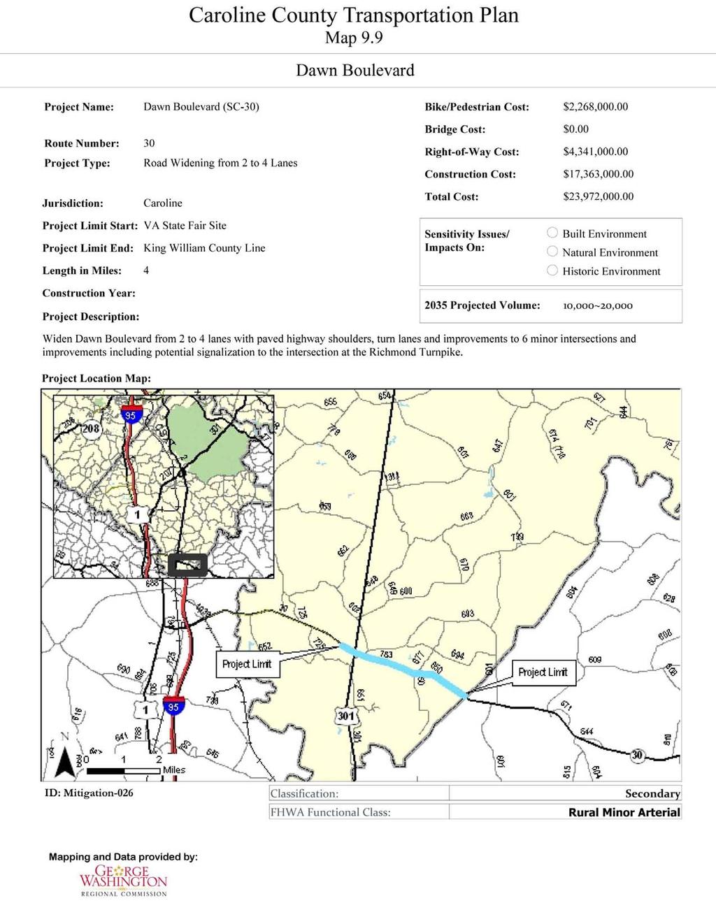
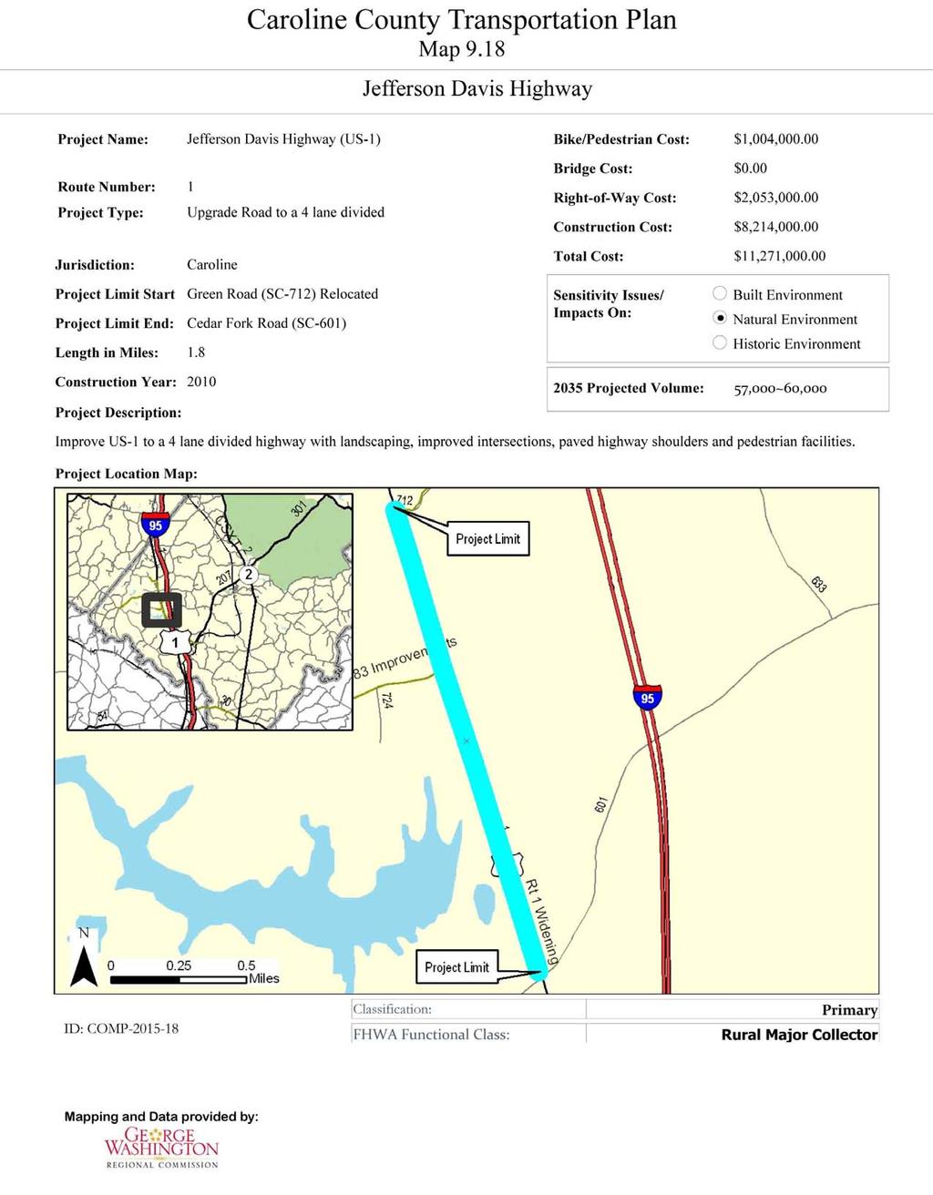
27 PROPOSED TRANSPORTATION IMPROVEMENTS Through the County s participation with the Fredericksburg Area Metropolitan Planning Organization (FAMPO), a regional long range transportation plan has been prepared identifying many planned or suggested improvements in the transportation system. A number of improvements previously identified in the comprehensive plan or the area plans, have been identified and adopted in the FAMPO 2035 Long Range Transportation Plan ( Map 9.6 from that plan identifies the road improvements contained in the plan. A brief description of each recommendation is contained below, together with a map reference to better identify the location and scope of the improvement. GENERAL NETWORK IMPROVEMENTS Several major roads in the County are important, not only because they provide access within the County, but because they serve as conduits for travelers to communities elsewhere. Traffic increases on these roads, regardless of whether it occurs from development within our borders, or more through travel, will negatively impact such roads in the future. The following roads are identified for improvement due to their importance for interstate and/or regional travel. RICHMOND TURNPIKE (ROUTE 301) - Design and reconstruct U.S. Route 301 from the Hanover County line to New Market Plantation (just south of Bowling Green) from two lanes to a rural four lane divided highway, as identified in VDOT s long term transportation plan (Map 9.7). This major transportation link will continue to grow in importance, providing an alternative to I-95 and the northeast corridor. Construction of the two additional lanes should be initiated by 2022 and completed by TIDEWATER TRAIL (ROUTE 17) is identified in State Long Range Transportation Plan as a candidate for upgrading from two to four lanes (Map 9.8). The development of Haymount and growth in neighboring Spotsylvania County, together with projected increases in through traffic, will necessitate the upgrading of Route 17 from New Post to Port Royal from two lanes to a four-lane rural divided highway. DAWN BOULEVARD (ROUTE 30) serves as an important conduit for commercial traffic to the paper mill in West Point and several commercial waste disposal facilities in the region. Development in Dawn, greater activity at the Meadow Events Park, and growth in neighboring Hanover County, together with increases in through traffic, will necessitate the upgrading of Route 30 from the Meadow Events Park to the King William County line to a four-lane rural divided highway (Map 9.9). A four lane urban section will be appropriate within the Village of Dawn. FREDERICKSBURG TURNPIKE (ROUTE 2) serves as a collector for traffic between Fredericksburg, Bowling Green, and points south. It provides access to the VRE station in Fredericksburg and the proposed station off of Route 17 in Spotsylvania County. Development around the Town of Bowling Green, together with more through traffic suggest that Route 2 should be improved to a four-lane rural divided highway from The Town of Bowling Green to the Spotsylvania County line (Map 9.10). I-95/ROUTE 207 INTERCHANGE IMPROVEMENTS Complete Phase 1 of the I-95/Route 207 interchange improvements (Route 207/Route 652 intersection relocation) as shown in Map Future improvements will include the relocation of the Route 207/Comfort Way intersection and the relocation of the northbound I-95 off ramp to westbound Route 207. Access to the future Carmel Church Multi-modal Transportation Center (Map 9.12) needs to be evaluated and designed, to ensure it complements other interchange improvements. JEFFERSON-DAVIS HIGHWAY (ROUTE 1) is identified as a major collector. It is currently a four lane undivided road, without turn lanes except at the intersections of Route 207 (Rogers-Clark Boulevard) and Route 639 (Ladysmith Road). This road serves as an alternative to I-95 and is critical in the event of an accident on the Interstate. Development in both Carmel Church and Ladysmith, the creation of Multi-modal Transportation Center, and additional through traffic will require the upgrading of Route 1 to a six lane rural divided highway (Maps 9.13 and 9.14). Chapter 9 - Transportation 9-26
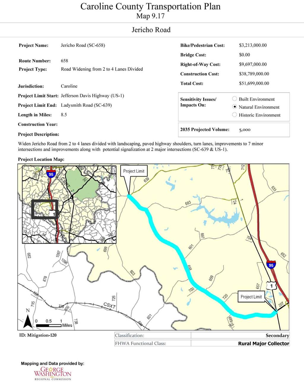
28 COMMUNITY OR AREA IMPROVEMENTS The adoption of area or community plans allowed the planning committees, VDOT and County staff the opportunity to evaluate local transportation needs in greater detail. This section discusses recommended improvements identified either during the community planning process or as a result of development concepts or proposals identified separate from those planning processes. Where appropriate, a map is included containing specific references to location, description and estimated cost of the improvements. BOWLING GREEN SCHOOL ROAD (ROUTE 814) from its terminus should be improved and extended to Chase Street, to provide better neighborhood access and improve access for emergency vehicles. Rezoning requests offer opportunities to connect a stub road from Chase Green though adjoining property to connect School Road to Chase Street. Creating this connection should be a condition of development as it occurs. CARMEL CHURCH ROGERS CLARK BOULEVARD - County regulations require full frontage improvements to be constructed as development occurs within the highway overlay corridor district. Improvements include a full travel lane and any turn lanes or tapers required by VDOT or recommended by a TIA. The Carmel Church Community Plan recommends service roads to provide inter-parcel access and reduce the number of intersections and median breaks along Route 207. Such crossings should be limited to key intersections and spaced 1, feet apart. DRY BRIDGE ROAD EXTENSION - Development in Carmel Church will require improvements to several secondary roads in the community. Dry Bridge Road (Route 684) should be realigned at its intersection with Route 207and extended to Moncure Drive (Route 716) to improve access within the area (Map 9.15). JERICHO ROAD (ROUTE 658) provides access between Carmel Church, Chilesburg, and Spotsylvania County. Development within Carmel Church and Ladysmith will increase local traffic. The Carmel Church Multi-modal Transportation Center will likely increase commuter traffic from Spotsylvania County. Widening this road (Map 9.16) to an improved two lane section (2020) and later upgrading it to a rural four lane divided collector (2035) are recommended (Map 9.17). LADYSMITH JEFFERSON DAVIS HIGHWAY (ROUTE 1) is currently a four lane undivided road. The build out anticipated in the Ladysmith Plan will significantly increase traffic in the community. The existing road configuration will be inadequate to handle the projected increases identified in the plan. Improvements to Route 1 are divided into three phases, shown in Maps 9.18 through LADYSMITH ROAD (ROUTE 639) from Countyline Church Road (Route 603) to just west of the intersection of Bull Church Road (Route 633) should be improved to provide better access (Map 9.21). Recommended improvements include expanding to a four or six lane divided roadway, wider travel lanes, wider shoulders, turn lanes at all major intersections, sidewalks and bike lanes, and realignment, where needed. The I-95/ Route 639 interchange should be reconstructed to include widening the Route 639 overpass to accommodate left turn lanes to north and southbound I-95, and reconstruction of the north and south bound exit ramps to accommodate left and right turn lanes. GREEN ROAD (ROUTE 712) from Route 1 to Route 639 should be realigned and reconstructed to a four lane divided highway (Map 9.22). Traffic from Lake Caroline and Pendleton to the I-95 interchange, together with commercial development along Ladysmith Road (Route 639), will require this improvement. The need for a four lane divided section with a median is likely in future years. GREEN ROAD (ROUTE 712) from Route 639 to Route 1 should be extended and align with the realigned portion to the South and with Durrette Road to the Northwest (Map 9.23). Chapter 9 - Transportation 9-27
29 GATEWOOD ROAD (ROUTE 604) will experience significant traffic increases due to Ladysmith Village. This road should be upgraded to an improved two lane standard to the Ladysmith Village entrance by 2015 (Map 9.24) and to the Countyline Church Road intersection by 2020 (Map 9.24). CCC ROAD (ROUTE 683) will experience significant traffic increases due to the Pendleton community. This road should be upgraded to an improved two lane standard to the Pendleton entrance by 2012 (Map 9.26) and to the Jericho Road intersection by 2020 (Map 9.27). CEDAR FORK AND GOLANSVILLE ROADS (ROUTE 601) will generally experience traffic increases due to development in the Ladysmith area. This road is an important alternative for local east-west traffic to Ladysmith Road (Route 639). This road should be upgraded to an improved two lane standard by 2020 (Map 9.28). BULL CHURCH ROAD (ROUTE 633) is an important north-south connector east of Interstate 95. It provides access to the two east-west roads (Route 639 and Route 601), as well as serving commercial and industrial development east of the interstate. This road should be reconstructed to an improved two lane section (Map 9.29). Development of abutting tracts of land may necessitate upgrading this road to a four lane divided section in the future. DURRETTE ROAD (ROUTE 622) will experience significant traffic increases due to Ladysmith Village. This road provides access to Lewis and Clark Elementary School, the South River neighborhood and Bridlewoods. It should be upgraded to an improved two lane standard to the Ladysmith Village entrance by 2015 by 2020 (Map 9.30). NORTH LADYSMITH CONNECTOR ROAD - A new road (Map 9.31) from Durrette Road (Route 622) Route 633 should be constructed on the north side of Ladysmith Road (Route 639). The road should connect to the relocated and reconstructed Green Road to provide improved traffic flow to Ladysmith Village, as well as commercial and industrial development north of Ladysmith Road. DAWN ROUTE 30/301 CONNECTOR - Development in the community of Dawn will bring additional traffic to both Dawn Boulevard and Richmond Turnpike. The improvements to those roads, identified earlier, are intended to ensure that the roads continue to function as arterials and collectors. To reduce the use of those roads by local traffic and to minimize impacts to the Route 30/301 intersection, a connector road is proposed in the northeast quadrant that would provide local access to that area and bypass the intersection (Map 9.32). OTHER IMPROVEMENTS Several other improvements are identified, either to assure consistency with the FAMPO 2035 Regional Long Range Plan or from previous planning documents. These improvements are as follows: PENOLA ROAD (ROUTE 601) from Richmond Turnpike (Route 301) to Rogers Clark Boulevard (Route 207) should be improved to provide better access between the southern part of the County and Route 207. Design and improvements should include improving site distance, wider pavement widths and wider shoulders. MACEDONIA ROAD (ROUTE 603) from Richmond Turnpike (Route 301) to the Spotsylvania County line should be improved to provide better access between northern Caroline and Route 17 in Spotsylvania County (Map 9.33). This road, which is designated and functions as a minor collector, will become increasingly important if the VRE station is constructed off of Route 17 in Spotsylvania County as proposed. All of the road improvements contained in this plan should include bicycle and pedestrian improvements identified earlier in this chapter. The adopted area plans should also be evaluated for other improvements that may be identified within the respective plan, but not included in this chapter. Chapter 9 - Transportation 9-28

30

31

32
33

34

35

36

37

38

39

40
41
42

43

44

45

46
47 Map 9.23

48 Map 9.24

49 Map 9.25

50 Map 9.26

51 Map 9.27

52 Map 9.28

53 Map 9.29

54 Map 9.30

55 Map 9.31

56 Map 9.32

57 Map 9.33
o n - m o t o r i z e d transportation is an overlooked element that can greatly enhance the overall quality of life for the community s residents.
 N o n - m o t o r i z e d transportation is an overlooked element that can greatly enhance the overall quality of life for the community s residents. 84 Transportation CHAPTER 11 INTRODUCTION Transportation
Multimodal Through Corridors and Placemaking Corridors
 68 Multimodal Through Corridors and Placemaking Corridors Corridors have different functions in a region. Some corridors are used to get smoothly and rapidly through a region or to get quickly to major
Chapter 5 Future Transportation
 Chapter 5 Future Transportation The Future Land Use Plan identifies the desired land use designations. The land uses desired for Crozet depend, in large part, on the success of the transportation system,
Corpus Christi Metropolitan Transportation Plan Fiscal Year Introduction:
 Introduction: The Safe, Accountable, Flexible, Efficient Transportation Equity Act: A Legacy for Users (SAFETEA-LU) has continued the efforts started through the Intermodal Surface Transportation Efficiency
Clackamas County Comprehensive Plan
 ROADWAYS The County s road system permits the movement of goods and people between communities and regions, using any of a variety of modes of travel. Roads provide access to virtually all property. They
West Dimond Blvd Upgrade Jodhpur Street to Sand Lake Road
 West Dimond Blvd Jodhpur St to Sand Lake CSS Transportation Project Summary Municipality of Anchorage Project # 05 005 Project Manager: John Smith, P.E. (MOA PM&E) Project Administrator: Julie Makela,
2045 Long Range Transportation Plan. Summary of Draft
 2045 Long Range Transportation Plan Summary of Draft Fredericksburg Area Metropolitan Planning Organization The George Washington Region includes the City of Fredericksburg and the counties of Caroline,
Appendix 3 Roadway and Bike/Ped Design Standards
 Appendix 3 Roadway and Bike/Ped Design Standards OTO Transportation Plan 2040 4/20/2017 Page A3-1 Adopted Standards The adopted OTO Design Standards and Major Thoroughfare Plan are contained herein.
CONNECTING PEOPLE TO PLACES
 CONNECTING PEOPLE TO PLACES 82 EAST BENCH MASTER PLAN 07 Introduction The East Bench transportation system is a collection of slow moving, treelined residential streets and major arteries that are the
INTRODUCTION THOROUGHFARE SYSTEM CLASSIFICATIONS
 INTRODUCTION The thoroughfare plan will assist public officials in the development of a specialized system for efficient and safe movement of vehicular traffic while minimizing potential conflicts with
Chapter 2: Standards for Access, Non-Motorized, and Transit
 Standards for Access, Non-Motorized, and Transit Chapter 2: Standards for Access, Non-Motorized, and Transit The Washtenaw County Access Management Plan was developed based on the analysis of existing
City of Wayzata Comprehensive Plan 2030 Transportation Chapter: Appendix A
 A1. Functional Classification Table A-1 illustrates the Metropolitan Council s detailed criteria established for the functional classification of roadways within the Twin Cities Metropolitan Area. Table
APPENDIX A: Complete Streets Checklist DRAFT NOVEMBER 2016
 APPENDIX A: Complete Streets Checklist DRAFT NOVEMBER 2016 Complete Streets Checklist MetroPlan Orlando s Complete Streets Checklist is an internal planning tool for staff to further implementation of
Chapter 7. Transportation. Transportation Road Network Plan Transit Cyclists Pedestrians Multi-Use and Equestrian Trails
 Chapter 7 Transportation Transportation Road Network Plan Transit Cyclists Pedestrians Multi-Use and Equestrian Trails 7.1 TRANSPORTATION BACKGROUND The District of Maple Ridge faces a number of unique
CITY OF COCOA BEACH 2025 COMPREHENSIVE PLAN. Section VIII Mobility Element Goals, Objectives, and Policies
 CITY OF COCOA BEACH 2025 COMPREHENSIVE PLAN Section VIII Mobility Element Goals, Objectives, and Policies Adopted August 6, 2015 by Ordinance No. 1591 VIII MOBILITY ELEMENT Table of Contents Page Number
Circulation in Elk Grove includes: Motor vehicles, including cars and trucks
 Circulation, as it is used in this General Plan, refers to the many ways people and goods move from place to place in Elk Grove and the region. Circulation in Elk Grove includes: Motor vehicles, including
5. RUNNINGWAY GUIDELINES
 5. RUNNINGWAY GUIDELINES These guidelines should be considered collectively when making runningway decisions. A runningway is the linear component of the transit system that forms the right-of-way reserved
TRASBURG RANSPORTATION
 TRASBURG RANSPORTATION LAN DEVELOPED BY THE TRANSPORTATION PLANNING DIVISION OF THE VIRGINIA DEPARTMENT OF TRANSPORTATION IN COOPERATION WITH THE U.S. DEPARTMENT OF TRANSPORTATION, FEDERAL HIGHWAY ADMINISTRATION
Route 7 Corridor Study
 Route 7 Corridor Study Executive Summary Study Area The following report analyzes a segment of the Virginia State Route 7 corridor. The corridor study area, spanning over 5 miles in length, is a multi
Exhibit 1 PLANNING COMMISSION AGENDA ITEM
 Exhibit 1 PLANNING COMMISSION AGENDA ITEM Project Name: Grand Junction Circulation Plan Grand Junction Complete Streets Policy Applicant: City of Grand Junction Representative: David Thornton Address:
NM-POLICY 1: Improve service levels, participation, and options for non-motorized transportation modes throughout the County.
 Transportation PRINCE WILLIAM COUNTY 2008 COMPREHENSIVE PLAN NON-MOTORIZED PLAN CONTENTS Goals, Policies, and Action Strategies Table 4 (Bike Facility Classifications and Descriptions) Table 5 (Bike Facility
JONESBORO HIGHWAY 63 HIGHWAY 18 CONNECTOR STUDY
 JONESBORO HIGHWAY 63 HIGHWAY 18 CONNECTOR STUDY Craighead County May 2007 JONESBORO HIGHWAY 63 HIGHWAY 18 CONNECTOR STUDY Craighead County May 2007 Prepared by Planning and Research Division Arkansas State
Classification Criteria
 SCHEDULE D TO RECOMMENDED OFFICIAL PLAN AMENDMENT NO. 40 SCHEDULE C-4 Road Criteria Criteria Traffic Service Objective Land Service/Access Typical Daily Traffic Volume Flow characteristics Travel Speed
Chapter 6 Transportation Plan
 Chapter 6 Transportation Plan Transportation Plan Introduction Chapter 6 Transportation Plan Transportation Plan Introduction This chapter describes the components of Arvada s transportation system, comprised
Access Management Regulations and Standards
 Access Management Regulations and Standards Efficient highway operation Reasonable property access Concept of Access Management The way to manage access to land development while simultaneously preserving
Item to be Addressed Checklist Consideration YES NO N/A Required Description Complete Streets Guidelines
 Passaic County Complete Streets Checklist - Concept Development Project Name Item to be Addressed Checklist Consideration YES NO N/A Required Description Complete Streets Guidelines Existing Plans Have
ACTIVE TRANSPORTATION
 ACTIVE TRANSPORTATION Mobility 2040 Supported Goals Improve the availability of transportation options for people and goods. Support travel efficiency measures and system enhancements targeted at congestion
Solana Beach Comprehensive Active Transportation Strategy (CATS)
") Solana Beach Comprehensive Active Transportation Strategy (CATS) 3.0 Goals & Policies The Solana Beach CATS goals and objectives outlined below were largely drawn from the Solana Beach Circulation Element
Solana Beach Comprehensive Active Transportation Strategy (CATS) 3.0 Goals & Policies The Solana Beach CATS goals and objectives outlined below were largely drawn from the Solana Beach Circulation Element
Roadway Classification Design Standards and Policies. Pueblo, Colorado November, 2004
 Roadway Classification Design Standards and Policies Pueblo, Colorado November, 2004 Table of Contents Page Chapter 1. General Provisions 1.1 Jurisdiction 3 1.2 Purpose and Intent 3 1.3 Modification 3
REGIONAL BICYCLE AND PEDESTRIAN DESIGN GUIDELINES
 REGIONAL BICYCLE AND PEDESTRIAN DESIGN GUIDELINES November 16, 2011 Deb Humphreys North Central Texas Council of Governments Bicycle and Pedestrian Advisory Committee Snapshot of the Guide 1. Introduction
Off-road Trails. Guidance
 Off-road Trails Off-road trails are shared use paths located on an independent alignment that provide two-way travel for people walking, bicycling, and other non-motorized users. Trails specifically along
Vision: Traditional hamlet with an attractive business/pedestrian friendly main street connected to adjacent walkable neighborhoods
 N D. Focus Area II Vision: Traditional hamlet with an attractive business/pedestrian friendly main street connected to adjacent walkable neighborhoods Transit Road Focus Area II is located in the Hamlet
MCTC 2018 RTP SCS and Madera County RIFP Multi-Modal Project Eval Criteria GV13.xlsx
 MCTC 8 RTP SCS and Madera County RIFP Multi-Modal Project Eval Criteria GV.xlsx Madera County Transportation Commission Regional Transportation Plan / Sustainable Communities Strategy Multi-Modal Project
NJDOT Complete Streets Checklist
 Background The New Jersey Department of Transportation s Complete Streets Policy promotes a comprehensive, integrated, connected multi-modal network by providing connections to bicycling and walking trip
Street Paving and Sidewalk Policy
 City Commission Policy 600 Street Paving and Sidewalk Policy DEPARTMENT: Public Works DATE ADOPTED: June 7, 1995 DATE OF LAST REVISION: December 10, 2014 Policy No. 600.01 AUTHORITY: PASS City of Tallahassee-Leon
Houma-Thibodaux Metropolitan Planning Organization STP<200K Funding Application APPLICATION
 APPLICATION HOUMA-THIBODAUX METROPOLITAN PLANNING ORGANIZATION (HTMPO) FOR SURFACE TRANSPORTATION PROGRAM (STP
ARTINSVILLE ENRY OUNTY REA RANSPORTATION TUDY
 ARTINSVILLE ENRY OUNTY REA RANSPORTATION TUDY DEVELOPED BY THE TRANSPORTATION AND MOBILITY PLANNING DIVISION OF THE VIRGINIA DEPARTMENT OF TRANSPORTATION IN COOPERATION WITH THE U.S. DEPARTMENT OF TRANSPORTATION,
Agenda. Overview PRINCE GEORGE S PLAZA METRO AREA PEDESTRIAN PLAN
 PRINCE GEORGE S PLAZA METRO AREA PEDESTRIAN PLAN May 28, 2008 Agenda Welcome and introductions Project overview and issue identification Planning context and strengths Design challenges and initial recommendations
TRAFFIC CALMING GUIDE FOR TORONTO CITY OF TORONTO TRANSPORTATION SERVICES DIVISION
 TRAFFIC CALMING GUIDE FOR TORONTO CITY OF TORONTO TRANSPORTATION SERVICES DIVISION CITY OF TORONTO TRANSPORTATION SERVICES DIVISION 2016 TRAFFIC CALMING GUIDE FOR TORONTO TABLE OF CONTENTS Introduction
2.0 LANE WIDTHS GUIDELINE
 2.0 LANE WIDTHS GUIDELINE Road Engineering Design Guidelines Version 2.0.1 May 2018 City of Toronto, Transportation Services City of Toronto Page 0 Background In early 2014, Transportation Services initiated
5 CIRCULATION AND STREET DESIGN
 5 CIRCULATION AND STREET DESIGN This chapter describes circulation and streetscape improvements proposed for the Northwest Chico Specific Plan Area. It includes detailed design specifications for existing
10.0 CURB EXTENSIONS GUIDELINE
 10.0 CURB EXTENSIONS GUIDELINE Road Engineering Design Guidelines Version 1.0 March 2017 City of Toronto, Transportation Services City of Toronto Page 0 Background In early 2014, Transportation Services
Access Management Regulations and Standards for Minor Arterials, Collectors, Local Streets
 Access Management Regulations and Standards for Minor Arterials, Collectors, Local Streets September 2009 Paul Grasewicz Access Management Administrator Concept of Access Management The way to manage access
Roads and Vehicular Traffic Design Principles. Roads and Vehicular Traffic Recommendations
 CIRCULATION AND PARKING roads and vehicular traffic The Campus Master Plan updates the campus transportation network through a multi-modal approach that encourages walking and biking while improving vehicular
Develop a Multi-Modal Transportation Strategy (Theme 6)
") DEVELOP A MULTI-MODAL TRANSPORTATION STRATEGY (THEME 6) WHY IS THIS THEME ADDRESSED? Develop a Multi-Modal Transportation Strategy (Theme 6) Statement of Ideal Reduce resident and visitor reliance on single
DEVELOP A MULTI-MODAL TRANSPORTATION STRATEGY (THEME 6) WHY IS THIS THEME ADDRESSED? Develop a Multi-Modal Transportation Strategy (Theme 6) Statement of Ideal Reduce resident and visitor reliance on single
SECTION 1 - TRAFFIC PLANNING
 SECTION 1 - TRAFFIC PLANNING 1.1 TRAFFIC OPERATIONS 1.1.1 Roadway Functional Classification The Multnomah County Comprehensive Framework Plan s Policy 34: Trafficways and the Functional Classification
Recommended Roadway Plan Section 2 - Land Development and Roadway Access
 Recommended Roadway Plan Section 2 - Land Development and Roadway Access SECTION 2 Land Development and Roadway Access 2.1 Land Use and Access Management The Federal Highway Administration (FHWA) defines
DRAFT - CITY OF MEDFORD TRANSPORTATION SYSTEM PLAN Roadway Cross-Sections
 Roadway Cross-Sections Medford s roadway cross-section standards apply to new and reconstructed roads. The crosssections take into consideration roadway function and operational characteristics, including
Active Transportation Facility Glossary
 Active Transportation Facility Glossary This document defines different active transportation facilities and suggests appropriate corridor types. Click on a facility type to jump to its definition. Bike
Proposed. City of Grand Junction Complete Streets Policy. Exhibit 10
 Proposed City of Grand Junction Complete Streets Policy Exhibit 10 1 City of Grand Junction Complete Streets Policy Vision: The Complete Streets Vision is to develop a safe, efficient, and reliable travel
Executive Summary Route 30 Corridor Master Plan
 Route Corridor Master Plan Project Overview The Route Corridor Master Plan is a coordinated multimodal transportation and land use plan for the entire stretch of Route through East Whiteland Township,
Driveway Design Criteria
 Design Manual Chapter 5 - Roadway Design 5L - Access Management 5L-4 Driveway Design Criteria A. General For efficient and safe operations, access drives and minor public street intersections can be improved
CHAPTER 5 TRANSPORTATION GOAL
 CHAPTER 5 TRANSPORTATION GOAL Create and sustain a transportation system that meets the demands for existing and future traffic; skillfully integrates existing and planned development; and provides a safe
Non-Motorized Transportation 7-1
 Non-Motorized Transportation 7-1 Transportation facilities no longer mean just accommodating a vehicle powered by a combustion engine. Pedestrian and non-motorized facilities are important modes of travel
Transportation Corridor Studies: Summary of Recommendations
 Transportation Corridor Studies: Summary of Recommendations Route 4 Corridor Study: Route 10 Corridor Study: Route 44 Corridor Study: Route 175 Corridor Study: Route 5/15 Corridor Study: Rentschler Field
City of Homewood Transportation Plan
 City of Homewood Transportation Plan Prepared for: City of Homewood, Alabama Prepared by: Skipper Consulting, Inc. May 2007 TABLE OF CONTENTS INTRODUCTION... 1 BACKGROUND INFORMATION... 1 EXISTING TRANSPORTATION
Basalt Creek Transportation Refinement Plan Recommendations
 Basalt Creek Transportation Refinement Plan Recommendations Introduction The Basalt Creek transportation planning effort analyzed future transportation conditions and evaluated alternative strategies for
This Chapter sets forth the minimum design, technical criteria and specifications to be used in the preparation of all roadway plans.
 4.1 GENERAL This Chapter sets forth the minimum design, technical criteria and specifications to be used in the preparation of all roadway plans. These Roadway Standards are for new construction and modification
Regional Transportation Needs Within Southeastern Wisconsin
 Regional Transportation Needs Within Southeastern Wisconsin #118274 May 24, 2006 1 Introduction The Southeastern Wisconsin Regional Planning Commission (SEWRPC) is the official areawide planning agency
Third Street Bridge & Corridor Project
 Third Street Bridge & Corridor Project Preparation for the FY2018 budget to commence October 1, 2017, includes funding to address a project that has been considered since 1994. The Third Street bridge
Transportation Master Plan Advisory Task Force
 Transportation Master Plan Advisory Task Force Network Alternatives & Phasing Strategy February 2016 BACKGROUND Table of Contents BACKGROUND Purpose & Introduction 2 Linking the TMP to Key Council Approved
APPENDIX G: INTERSECTION NEEDS AT OKEECHOBEE BOULEVARD
 APPENDIX G: INTERSECTION NEEDS AT OKEECHOBEE BOULEVARD INTERSECTION NEEDS AT SR 7 and OKEECHOBEE BOULEVARD SR 7 Extension Project Development and Environment (PD&E) Study From Okeechobee Boulevard (SR
ARRENTON RANSPORTATION
 ARRENTON RANSPORTATION LAN DEVELOPED BY THE TRANSPORTATION PLANNING DIVISION OF THE VIRGINIA DEPARTMENT OF TRANSPORTATION IN COOPERATION WITH THE U.S. DEPARTMENT OF TRANSPORTATION, FEDERAL HIGHWAY ADMINISTRATION
2.0 Existing Conditions
 20 2.0 Existing Conditions 2.1 Land Use, Future Growth Patterns, Physical Barriers Geographic Overview Sutter County s land use pattern is characterized by extensive agricultural areas, significant natural
NEIGHBORHOOD TRAFFIC CALMING POLICY
 NEIGHBORHOOD TRAFFIC CALMING POLICY I. PURPOSE The City of Kent continually strives to strengthen and protect its neighborhoods by improving the quality of life in residential areas. Traffic conditions
Town of Bethlehem. Planning Assessment. Bethlehem Town Board
 Town of Bethlehem US 9W Corridor Transportation Planning Assessment Presented e to: Bethlehem Town Board June 2009 Overview Study Background Route 9W Corridor Conditions and Improvements Selkirk Bypass
GOAL 2A: ESTABLISH AND MAINTAIN A SAFE, CONVENIENT, AND EFFICIENT MULTI-MODAL TRANSPORTATION SYSTEM TO MOVE PEOPLE AND GOODS THROUGHOUT THE CITY.
 2. TRANSPORTATION ELEMENT The purpose of this element is to assist in establishing an adequate transportation system within the City and to plan for future motorized and non-motorized traffic circulation
CITY OF LUCAS 2014 MASTER THOROUGHFARE PLAN
 INTRODUCTION CITY OF LUCAS 2014 MASTER THOROUGHFARE PLAN A thoroughfare system is intended to provide an effective means of moving vehicles within and through a city. The thoroughfare plan will assist
Planning Guidance in the 2012 AASHTO Bike Guide
 Planning Guidance in the 2012 AASHTO Bike Guide Presentation by: RJ Eldridge Peter Lagerwey August 22, 2012 WEBINAR 2: PLANNING GUIDANCE IN THE 2012 AASHTO BIKE GUIDE Today s Webinar Significant Updates
City of Elizabeth City Neighborhood Traffic Calming Policy and Guidelines
 City of Elizabeth City Neighborhood Traffic Calming Policy and Guidelines I. Purpose: The City of Elizabeth City is committed to ensure the overall safety and livability of residential neighborhoods. One
2025 Comprehensive Plan for the City of Temple Terrace Florida. Mobility Element. Adopted by City Council June 30, 2009
 2025 Comprehensive Plan for the City of Temple Terrace Florida Mobility Element Adopted by City Council June 30, 2009 Effective Date September 22, 2009 GOAL 2: To protect and promote the quality of life
Living Streets Policy
 Living Streets Policy Introduction Living streets balance the needs of motorists, bicyclists, pedestrians and transit riders in ways that promote safety and convenience, enhance community identity, create
Contents. Champaign-Urbana Mass Transit District Stop Placement Guidelines
 Contents Champaign-Urbana Mass Transit District Introduction... 1 Stop Spacing... 2 Rural... 2 Low Density Suburban... 2 General Urban... 2 Urban Core... 2 Operational Safety... 3 Stop Placement... 4 Nearside
MAG Town of Cave Creek Bike Study Task 6 Executive Summary and Regional Significance Report
 Page 1 MAG Town of Cave Creek Bike Study Task 6 Executive Summary and Regional Significance Report August 1, 2012 MAG Project #481 Page 2 Task 6 Executive Summary and Regional Significance Report Introduction
County of Greenville South Carolina. Traffic Calming Program Neighborhood Traffic Education Program and Speed Hump Program
 County of Greenville South Carolina Traffic Calming Program Neighborhood Traffic Education Program and Speed Hump Program (rev) August 2008 I. PURPOSE The potential negative impacts from vehicular traffic
Project Description Form 8EE
 Project Description Form 8EE Basic Project Information Submitting Jurisdiction/Agency: Town of Dumfries Project Title: Route 1 (Fraley Blvd) Widening: Brady's Hill Road to Dumfries Road Project Location:
Highway 217 Corridor Study. Phase I Overview Report
 Highway 217 Corridor Study Phase I Overview Report November 3, 24 BACKGROUND AND OVERVIEW Study purpose The Highway 217 Corridor Study is developing multi-modal transportation solutions for traffic problems
M-58 HIGHWAY ACCESS MANAGEMENT STUDY Mullen Road to Bel-Ray Boulevard. Prepared for CITY OF BELTON. May 2016
 M-58 HIGHWAY ACCESS MANAGEMENT STUDY Prepared for CITY OF BELTON By May 2016 Introduction Missouri State Highway 58 (M-58 Highway) is a major commercial corridor in the City of Belton. As development has
DRAFT BUENA VISTA 2020 TRANSPORTATION PLAN
 DRAFT BUENA VISTA 2020 TRANSPORTATION PLAN DEVELOPED BY THE TRANSPORTATION PLANNING DIVISION OF THE VIRGINIA DEPARTMENT OF TRANSPORTATION IN COOPERATION WITH THE U.S. DEPARTMENT OF TRANSPORTATION, FEDERAL
Broad Street Bicycle Boulevard Design Guidelines
 Broad Street Bicycle Boulevard Design Guidelines Building from the strategies introduced in the 2013 Bicycle Transportation Plan and community input received thus far, City Transportation Staff have identified
Land Use and Transportation Town Hall September 17, 2018
 Land Use and Transportation Town Hall September 17, 2018 Welcome! Tonight s Agenda: 7:00-7:30 OVERVIEW PRESENTATIONS 7:30-8:15 BREAKOUT SESSIONS 8:15 - End TOWN HALL CITIZEN S TIME Purpose of Tonight s
CURBSIDE ACTIVITY DESIGN
 5 CURBSIDE ACTIVITY DESIGN This chapter provides design guidance for separated bike lanes adjacent to curbside activities including parking, loading and bus stops. Typical configurations are presented
General Design Factors
 Chapter 3: 3-1.0 Introduction General Design Factors Mn/DOT s goals include encouraging and accommodating safe bicycling. From a design perspective, these goals are achieved by first having an understanding
CITY OF BLOOMINGTON COMPLETE STREETS POLICY
 CITY OF BLOOMINGTON COMPLETE STREETS POLICY POLICY OBJECTIVE: The City of Bloomington will enhance safety, mobility, accessibility and convenience for transportation network users of all ages and abilities,
Madison Urban Area and Dane County. Bicycle Transportation Plan Summary. September Introduction. Bicycle Plan Scope and Planning Process
 Bicycle Transportation Plan Summary Madison Urban Area and Dane County Introduction September 2000 Bicycling is an important mode of transportation in the Madison urban area and countywide that is available
Town of Mooresville, North Carolina Neighborhood Traffic Calming and Control Device Policy
 Town of Mooresville, North Carolina Neighborhood Traffic Calming and Control Device Policy Adopted January 6, 2014 Town of Mooresville Development Services Department TOWN OF MOORESVILLE NEIGHBORHOOD TRAFFIC
City of Novi Non-Motorized Master Plan 2011 Executive Summary
 City of Novi Non-Motorized Master Plan 2011 Executive Summary Prepared by: February 28, 2011 Why Plan? Encouraging healthy, active lifestyles through pathway and sidewalk connectivity has been a focus
CHAPTER 16 PEDESTRIAN FACILITIES DESIGN AND TECHNICAL CRITERIA TABLE OF CONTENTS
 CHAPTER 16 PEDESTRIAN FACILITIES DESIGN AND TECHNICAL CRITERIA TABLE OF CONTENTS Section Title Page 16.1 General... 16-1 16.1.1 AASHTO Reference... 16-1 16.1.2 ADA Requirements... 16-1 16.2 Sidewalks...
ACTIVE TRANSPORTATION/NONMOTORIZED TRANSPORTATION
 ACTIVE TRANSPORTATION/NONMOTORIZED TRANSPORTATION BACKGROUND Active transportation, also known as nonmotorized transportation, is increasingly recognized as an important consideration when planning and
2. TRANSPORTATION ELEMENT.
 2. TRANSPORTATION ELEMENT. The purpose of this element is to assist in establishing an adequate transportation system within the City and to plan for future motorized and non-motorized traffic circulation
Chapter 5 FUNCTIONAL CLASSIFICATION
 Chapter 5 FUNCTIONAL CLASSIFICATION Functional classification is a system by which streets and roadways may be distinguished by types according to their function within the entire transportation network.
C C C
 C-012-001 Thank you for your support for the creation of new public space and nonmotorized access between downtown and the waterfront through the Overlook Walk, the East-West Connections, and the Promenade.
East Burke Transportation, Safety and Capacity Improvements
 East Burke Transportation, Safety and Capacity Improvements The purpose of this project is to increase mobility and improve safety for pedestrians, cyclists, and motor vehicles along VT Route 114 in the
SETTINGS AND OPPORTUNITIES MOBILITY & ACCESS
 7 mobility & access how do people use el camino what is it like to drive on el camino/to park along el camino what is the pedestrian experience like what is the role of transit along the corridor what
Access Location, Spacing, Turn Lanes, and Medians
 Design Manual Chapter 5 - Roadway Design 5L - Access Management 5L-3 Access Location, Spacing, Turn Lanes, and Medians This section addresses access location, spacing, turn lane and median needs, including
APPROVE A RESOLUTION ADOPTING A COMPLETE STREETS POLICY
 STAFF REPORT MEETING DATE: September 13, 2016 TO: FROM: City Council Bob Brown, Community Development Director Russ Thompson, Public Works Director Patrick Filipelli, Management Analyst 922 Machin Avenue
PennDOT Access Management Model Ordinances Training
 PennDOT Access s Training Trainers: Chad Dixson, AICP, TPD Angela Watson, PB Objective of Today Assist Pennsylvania s municipalities and transportation professionals in better understanding the benefits
Gordon Proctor Director Policy on Accommodating Bicycle and Pedestrian Travel on ODOT Owned or Maintained Facilities
 Approved: Policy: 20-004(P) Responsible Office: Planning Gordon Proctor Director Policy on Accommodating Bicycle and Pedestrian Travel on ODOT Owned or Maintained Facilities I. POLICY STATEMENT: This policy
Parks Highway: MP Lucus Road to Big Lake Road
 2 Purpose and Need 2.1 Corridor History The Parks Highway is a 324-mile long Rural Interstate Highway that extends from its intersection with the Glenn Highway north to Fairbanks, Alaska. The Parks Highway
This page intentionally left blank.
 This page intentionally left blank. COMMUNITY Coweta Community Overview Coweta Coweta, a residential community located in Wagoner County, is a suburb of Tulsa situated southeast of the metropolitan area