IN THE MATTER OF: The Resource Management Act 1991
|
|
|
- Vernon Knight
- 5 years ago
- Views:
Transcription
1 BEFORE THE CANTERBURY REGIONAL COUNCIL AND THE ASHBURTON DISTRICT COUNCIL IN THE MATTER OF: The Resource Management Act 1991 AND IN THE MATTER OF: resource consent applications by Rangitata Diversion Race Management Limited to the Canterbury Regional Council and Ashburton District Council for resource consents for the construction, operation and maintenance of the Klondyke Water Storage Facility, its associated water takes from and discharges to the Rangitata River, and all associated activities EVIDENCE OF ROBERT JAMES GREENAWAY Dated: 28 March 2018
2 2 Contents QUALIFICATIONS AND EXPERIENCE... 3 EXECUTIVE SUMMARY... 4 SCOPE OF EVIDENCE... 4 METHOD... 8 ASSESSMENT OF EFFECTS - KSP... 8 SUBMISSIONS - KSP Flow reductions Effects on terrestrial Peel Forest recreation Recreation access to the River Birds ASSESSMENT OF EFFECTS FISH SCREEN SUBMISSIONS FISH SCREEN OFFICER S REPORT Canterbury Regional Council Ashburton District Council CONDITIONS CONCLUSION References Attachment 1: Summary of recreational use Attachment 2: Summary of kayak flow preferences Attachment 3: Summary of fishing flow preferences Attachment 4: Summary of rafting flow preferences Attachment 5: Summary of jet boating flow preferences Attachment 6: Revised Draft White Water Course Management Plan... 41
3 3 QUALIFICATIONS AND EXPERIENCE 1 My name is Robert James Greenaway. 2 I graduated from Lincoln University in 1987 with a three-year Diploma in Parks and Recreation Management with Distinction, and completed 18 months of postgraduate study in conservation management. I hold the status of an Accredited Recreation Professional with the NZ Recreation Association (NZRA), and until recently was the Chair of the NZRA Board of Accreditation for member accreditation to professional status, but remain a Board member. I am also a core group member of the New Zealand Association for Impact Assessment. In 2011 I was appointed as an inaugural Board member of the Sir Edmund Hillary Outdoor Recreation Council, to assist Sport New Zealand with the implementation of the National Outdoor Recreation Strategy, amongst other things. 3 I was awarded the Ian Galloway Memorial Cup in 2004 by the NZRA (of which I am a past Executive member) to recognise excellence and outstanding personal contribution to the wider parks industry. In 2013 I was awarded the status of Fellow with the NZRA. 4 Between 1990 and 1995 I worked with an international tourism and recreation development consultancy, Tourism Resource Consultants, on a range of large and small development and advisory projects. This work included ecotourism development planning in Samoa, for potential World Heritage Sites in the Solomon Islands for the Ministry of Foreign Affairs and Trade, event management (multisport and mountain biking), and domestic reserve, tourism and recreation management planning. 5 Between 1995 and 1997 I worked for Boffa Miskell Limited in Christchurch, focusing on recreation planning for local authorities and tourism development planning for private agencies. 6 Since 1997 I have worked independently. The majority of my work is for private companies, local and central government, and environmental and community agencies. Over the past ten years I have prepared assessments and evidence about recreation and tourism for (amongst other): the Porter Heights Ski Area, Contact Energy (Clutha River), Meridian Energy (Project Hayes wind farm, Manapouri hydro, Central Wind, Mokihinui hydro, North Bank Tunnel Concept hydro, Hunter Downs irrigation, Hurunui Wind, Waiau (Amuri) hydro), TrustPower (Wairau hydro, Arnold hydro, Patea hydro,
4 4 Matahina hydro, Lake Kaniere hydro, Lake Coleridge irrigation and hydro), Genesis Energy (Castle Hill wind), Mighty River Power (Puketoi wind), King Country Energy (Mokau hydro), Marlborough District Council (King Salmon), NZone Skydive (airfield reconsenting), the New Zealand Recreational Sport Fishing Council (Snapper 1 quota review), the New Zealand Fish and Game Council (Hurunui River) and MainPower (Mt Cass wind farm), Auckland Transport (Redoubt-Mill Road notice of requirement), NZ Transport Agency (several major roading projects). I have completed more than 350 consultancy projects nationally since 1997 and have presented evidence at more than 80 resource management hearings. 7 In preparing my evidence I have reviewed the code of conduct for expert witnesses contained in part 7 of the Environment Court Practice Note I have complied with it in preparing my evidence. I confirm that the issues addressed in this statement of evidence are within my area of expertise. I have not omitted to consider material facts known to me that might alter or detract from the opinions expressed. EXECUTIVE SUMMARY 8 My evidence considers the effects on recreation amenity of the proposed Klondyke Water Storage Facility, or KSP, and the installation of a new mesh fish screen to replace the existing BAFF device. I also review a proposed white water course to be developed near the KSP in response to expectations of the Ashburton Zone Committee Regional Implementation Plan for the Canterbury Water Management Strategy for a new water-based recreation facility to be developed on irrigation infrastructure within 1.5 hours drive of Ashburton. 9 I consider, primarily, in-river recreation and the effects of changes in water quantity, relying on the evidence of Mr Bas Veendrick to measure these changes. The flow changes proposed, as noted by the Canterbury Regional Council (CRC) s42a Officer s Report, comply with the Rangitata Water Conservation Order (RWCO). 10 The Rangitata River is well-recognised as an outstanding waterway for white water recreation and fishing, as illustrated by the RWCO. This status, for recreation values, is based on: salmon angling which occurs mostly downstream of SH1, but also extends up to the Rangitata Gorge; rafting and kayaking in the Gorge, but also including particularly for educational purposes kayaking and rafting between the Gorge and the Arundel Bridge
5 5 (although most educational trips end upstream of Peel Forest) 1 ; jet boating above the Gorge, but which also occurs below SH1 (where it is mostly associated with salmon angling); and wild, scenic and other natural characteristics upstream of the RDR intake. The reach between the Gorge and SH1 is rarely run by jet boats due to the rocky nature of the riverbed and the infrequency of suitable flows and water clarity; the paucity of suitable flows (largely resulting from the long-term, but legally authorised abstractions some of which have occurred following the gazettal of the Rangitata River Water Conservation Order). Peel Forest and Mount Peel are important terrestrial recreation settings nearby. There are formal public access opportunities to the River at Shepherds Bush Road, where the KSP is proposed to be constructed, and along the RDR canal near the new fish screen site. 11 With the proposed KSP a 10 m 3 /s flood flow harvest is sought. This will affect the availability of in-river flows above 98 m 3 /s between the RDR intake and the Arundel Bridge (that is, residual flows after the existing RDR take), and flows above 78 m 3 /s downstream of Arundel (and the existing 20 m 3 /s Rangitata Water Ltd abstraction there). This means that, during the main recreation season of 1 November to 30 April, the availability of moderate flows generally preferred for white water education (rafting and kayaking) and salmon angling are slightly enhanced while the high flows generally preferred by advanced rafters and kayakers are slightly reduced. There is no effect on the frequency of low flows which inhibit rafting or kayaking passage. 12 For example, while there is no change to the availability of the 40 to 80 m 3 /s band preferred by salmon anglers above the Arundel Bridge, downstream of the Bridge the number of days of flow availability changes from an existing seasonal average of 87.8 days to 93.2 days (+5.7). There are similar but smaller changes (increases) for kayaking and rafting flows preferred for educational purposes. 13 For the higher flow bands preferred by more advanced kayakers and rafters, above 98 m 3 /s, there are, for example, losses of up to 3.5 days per average annual recreation season (from 20.1 days existing) between the RDR intake 1 I take this to be the water-based recreation which is described as significant in the RWCO between the bottom of the Gorge and the Arundel Bridge. There is no specific reference in the RWCO to rafting and kayaking in this river section in the RWCO but their educational values in this river section are referred to in the tribunal s report.
6 6 and the Arundel Bridge for the 100 to 150 m 3 /s flow band upstream of the Arundel Bridge. 14 My assessment is that, while there is a small loss to the preferred flows for more advanced kayakers although they will be difficult to perceive due to their scale and occurrence during periods of natural flow change the increase of preferred flows for educational purposes on a river reach renowned for this particular value represents an acceptable balance. There is no new impediment to using the River for recreation. 15 The current fish pass takes and returns a maximum of 3m 3 /s of water between 10 September and 15 March to and from the River at Klondyke over a distance of just over 2380 m. The proposed new fish screen requires a bypass take and return of 3m 3 /s over a shortened distance of 1380 m for flows below m 3 /s measured at Klondyke (before the RDR intake); up to 4 m 3 /s for flows between and m 3 /s; and up to 5 m 3 /s for flows above m 3 /s. The new fish pass would operate all year, compared to the current screen which operates only between 10 September and 15 March. The 5 m 3 /s fish bypass flow will only operate when the full 10 m 3 /s flood flow take is abstracted through the RDR intake. 16 For the main recreation season, changes of an additional 2 m 3 /s will occur with the new fish screen in place only from 16 March to the end of April. The ability to discern these changes will therefore be very difficult, and at flows above 40 m 3 /s will have no effect on the ability to traverse the affected reach by raft or kayak. Although these changes are slight and will affect a short section of River (and a shorter section than currently), they include a particularly rocky shallow rapid. I have therefore made an effort to minimise the size of the bypass take with a particular focus on avoiding any change to flows below 40 m 3 /s which has required some additional design work on the screen structure to ensure its effective operation at low flows. 17 I have recommended conditions to ensure public access is maintained where new structures are built, and have consulted with Walking Access New Zealand to ensure their suitability. 18 I have relied on the evidence of Dr Greg Ryder and Dr Mark Sanders to review potential effects on in-river and terrestrial biota (salmonids and game birds) respectively, and Mr Stephen Brown to consider landscape effects. There are no apparent issues with hunting for small game or likely changes to recreation participation resulting from the visibility of new structures. I
7 7 understand that there are some differences in opinion relating to in-river ecology effects between Dr Ryder and the CRC s42a Officer s Report, but based on Dr Ryder s conclusions, there are no adverse effects on salmonids of relevance to recreation (and the new screen design will be a benefit). 19 The Ashburton District Council (ADC) s42a Officer s Report notes the recreation benefits afforded by the proposed white water course, and I have revised the Draft White Water Course Management Plan to reflect the ADC s disinterest in being involved in its operation. The revised management plan, which is attached to my evidence, places this onus fully on RDRML, and I recommend that it forms a trust to manage and operate it. SCOPE OF EVIDENCE 20 My evidence addresses two proposals: 20.1 The potential effects of the Klondyke Water Storage Facility, or KSP, on recreation values within the Rangitata River due to flow modifications, and at and near the storage pond site, including the following developments: a) New control and intake structures on the Rangitata Diversion Race (RDR) to move water into and out of the KSP; b) Installation of a new mesh fish screen, 1.8 km downstream of the RDR intake and immediately downstream of the existing bioacoustic fish fence (BAFF) and sand trap, and decommissioning of the BAFF; c) The storage pond and embankments; d) An emergency spillway that would allow water to be returned to the Rangitata River down a gully in the south-western corner of the site; e) Re-alignment of part of Shepherds Bush Road; f) Construction of a standing wave feature at the outlet of the KSP (a white water course ); and g) Creation of a 6 ha ecological refuge in the lower terrace area The effects of the modified fish pass and screen proposed to replace the existing BAFF device near the RDR intake on the Rangitata River.
8 8 METHOD 21 My assessment is based on: a) Site visits, including rafting the Rangitata River from immediately above the RDR intake at Klondyke to the rafting get-out used by the Peel Forest Outdoor Education Centre approximately 11 km below the intake. b) Literature review. I completed a preliminary literature review in May 2015 to advise project design which identified: public access issues, the desire stated in the Ashburton Zone Committee Regional Implementation Plan to create a regionally significant water-based recreation opportunity within 1.5 hours drive of Ashburton, and the need to assess flow changes in the Rangitata River throughout its range (although the proposed take complies with the Water Conservation (Rangitata River) Order 2006 (WCO) minimums). Further review was completed to support an analysis of the project as proposed. My references appear in Attachment 1. c) Participation in the community consultation programme carried out by Rangitata Diversion Race Management Ltd (RDRML), including direct communication with white water kayaking and jet boating representatives and the relevant Walking Access Commission field officer. d) Communication with other relevant technical experts contracted to advise the project, particularly those focusing on: in-river and terrestrial ecology, water quality, scheme design, landscape, hydrology and design of the white water course. e) Preparation of a peer-reviewed draft management plan for the proposed white water course. f) Input into the conditions of consent which are appended to the evidence of Mr David Greaves. g) Review of submissions and the CRC and ADC officers reports. ASSESSMENT OF EFFECTS - KSP 22 Recreational uses of the Rangitata River considered in this assessment are those which gain amenity from flows above the minimum level defined by the WCO; specifically jet boating, kayaking, trout and salmon fishing and rafting. All these activities on the River, apart from trout fishing, are
9 9 considered to be outstanding at the national level by the RWCO. I also consider effects on whitebaiting, hunting and swimming, along with public access to the River at the development site; and cumulative effects. 23 The proposal responds to the recommendations of the Ashburton Zone Committee Regional Implementation Plan for the Canterbury Water Management Strategy. This Strategy seeks a new regionally-significant water-based recreation opportunity developed within 1.5 hours drive of Ashburton; in this case a consent for an artificial standing wave feature on the Mayfield Hinds irrigation off-take near the development site. A new fish screen is also proposed. 24 Figure 1 in Attachment 1 locates the five main recreation uses and their relative indicative levels of activity on the Rangitata River. This figure also shows the four river divisions referred to in the RWCO and the six divisions that I have used in my review (as they better reflect different recreation opportunities). The River below the SH1 Bridge is likely to have the greatest level of use due to its popularity for salmon fishing. The Gorge and section downriver to Peel Forest has the most diverse use, with all five activities represented, and notably those associated with education programmes. Low levels of use for all five activities will occur throughout the River, and the section from Arundel Bridge to SH1 is the least used. Other activities include whitebaiting at the mouth, and swimming (contact recreation) and wildfowl hunting throughout the River corridor. 25 The RWCO defines the River as outstanding throughout for salmon fishing, outstanding above the Gorge (the Upper Rangitata ) for jet boating, rafting and canoeing, and from the top of the Gorge to Arundel Bridge for rafting and kayaking. My Attachments 2 to 5 summarise the data that I have used to identify the preferred river flows for each of these activities. 26 Flow regime effects of the KSP are considered for the two reaches: Rangitata Diversion Race (RDR) intake at Klondyke to Arundel Bridge; and from the Arundel Bridge to the sea (see my Figure 1 in Attachment 1). 27 The KSP has different effects on flows above and below Arundel Bridge due to the 20 m 3 /s Rangitata Water Ltd abstraction at Arundel. The proposed KSP water take results in no change in flow availability suited to trout fishing or jet boating below SH1 (where the vast majority of jet boating occurs). There are increases in the availability of the preferred flow bands for all forms of kayaking (beginner, intermediate and advanced), for salmon fishing and
10 10 rafting, as shown in my Table 1. These data are based on analysis provided to me by Mr Veendrick, as described in his evidence, and refer to flows below the fish bypass return. Table 1 also includes flow bands (without bracketed text) identified through consultation as being of interest to White Water New Zealand (WWNZ). Table 1: Existing and change in average days flow band 2 availability, 1 Nov 30 April RDR to Arundel Bridge Arundel Bridge to Sea Flow band (m 3 /s) Existing Change Existing Change <60 (trout) (salmon) (kayak) (kayak) (kayak) (raft) (jet to SH1) (jet below SH1) n/a n/a There are no changes to residual flows below 98 m 3 /s between the RDR intake and the Arundel bridge, and no changes below 78 m 3 /s downstream of Arundel. 29 The key modification is the increase in the period flows are between 75 and 85 m 3 /s downstream of Arundel Bridge (+5.4 days) and between 95 and 100 m 3 /s between the RDR intake and Klondyke and Arundel Bridge (+5.6 days). As the flow ranges preferred for recreation are quite broad (and refer to preferred ranges rather than minimums), this increase in the occurrence of a specific flow is unlikely to be material, although there is some loss in the availability of: 2 Flow bands are, for example, and In my AEE report I entered the data incorrectly for the RDR to Arundel Reach for the m3/s flow band. This is the corrected data. I discuss this further in response to submissions in my paragraph 49.
11 Flows above 85 m 3 /s between the Arundel Bridge and SH1 which suit adventure jet boaters. There will be a shift from an availability of 34.8 days per summer season (1 Nov to 30 April) existing to 29.9 days under the proposal a loss of 4.9 days or 14%. This section of River is used by approximately 20 jet boaters per year. High flows in the 100+ m 3 /s range are often associated with high turbidity and low amenity for jet boating, particularly in adventure boating settings. This leaves a narrow pre-existing band of availability in the 80 to 100 m 3 /s band, and little change in this Flows above 100 m 3 /s for advanced kayakers between the RDR intake and the Arundel Bridge. There will be a shift from 38.1 days per summer season (1 Nov to 30 April) existing to 32.5 days under the proposal a loss of 5.6 days or 14.7%. There are no use data for kayakers Flows in the preferred flow bands for salmon angling, all other kayaking, and rafting above the Arundel Bridge, specifically: 5.4 more days (from an existing base on 87.8 days) in the m 3 /s flow band below the Arundel Bridge preferred by salmon anglers, and 3.8 more days (from an existing base on 80.1 days) in the m 3 /s flow band in the Arundel Reach preferred by rafters, and increases in availability for all flow bands for beginner, intermediate and experienced kayakers in the Arundel Reach, with no changes to flows for jet boating below SH1. 30 It is important to note that the changes in availability of flow bands for recreation are unlikely to occur in contiguous periods. For example, the availability of the m 3 /s band (identified through consultation as of interest to kayakers below the RDR intake) is currently available on 8.4 days per summer season (4.6% of the time) between the RDR and Arundel, with a loss of 1.1 days. This may be represented by many periods of hours or minutes, and includes night-time flows. The coincidence of a recreational user and the availability of such narrow and occasional flow bands is quite low. If a kayaking opportunity is within a period of 10 hours of good light over 24 hours, the average availability of a flow of m 3 /s drops to 3.5 non-contiguous days per season and the loss to 10.8 hours. If this flow band occurs on a rising flood, which river users should avoid, the flow availability further decreases.
12 12 31 Reviews of freshwater and terrestrial ecology and birds indicate very little potential for adverse effects on fishing and hunting opportunities. Dr Greg Ryder considers the abstraction to be unlikely to result in ecologically meaningful effects on downstream aquatic biota, and Dr Mark Sanders finds that the proposal should result in a net benefit to birds. The landscape assessment by Mr Stephen Brown indicates potential for low to moderate effects on visual amenity from the visibility of the outfall structure from elevated positions in Peel Forest, and for moderate effects during the construction period. These are unlikely to depress recreational use of Peel Forest. 32 At the development site, the proposed storage pond will overlie an existing legal road (Shepherds Bush Road). The formation of this road matches its legal alignment until the top of the Rangitata River terrace. At this point, the legal alignment begins to deviate from a formed farm road and does not provide practical vehicle or walking access below the terrace, and does not connect with the riverbed for approximately 6 km until it meets Baxters Road to the east. Although much public information suggests that there is legal access to the River immediately off Shepherds Bush Road, this is incorrect and pedestrian access only is permitted by the grace of the landowner, as indicated by on-site signs. 33 The proposal includes reinstating Shepherds Bush Road to the top of the River terrace, formalising public access to the River via an easement in favour of the public for foot access only, and providing car parking at the road end. 34 A standing wave feature is included in the consent application which would provide a reliable standing wave. This white water course would provide a family-focused recreation setting within a 40-minute drive from Ashburton. It would suit kayak training and more challenging surfing, boarding and surfkayaking options. The proposal by RDRML at this stage is to gain consent for the construction and operation and operation of the course. Operational issues, such as water quality monitoring, surveillance and safety, and hours of operation are developed in the peer-reviewed draft management plan for the proposal (Attachment 6 to my evidence). It is intended that there would be no charge for access to the wave, although should an event be organised, a fee may be required by the organisers to cover supervision and perhaps fund-raising.
13 13 35 The white water course proposal responds to a recommendation from the Ashburton Zone Committee Regional Implementation Plan which included (its Annex p6): In determining the overall viability of any new distributive infrastructure consideration shall be given to delivering at least 1 new regionally significant water based recreation opportunity within 1.5 hours drive of Ashburton, but that there is not a requirement to deliver such a facility where it is found to compromise the viability of any new distributive infrastructure. 36 I prepared a draft management plan in late 2016 for the proposed course based on the NZ Recreation Association s 2015 Aquatic Facility Guidelines. This draft was peer reviewed by a panel appointed by the NZ Recreation Association, which included two lecturers in outdoor instruction, an aquatics facility specialist and the Chief Executive of WaterSafe Auckland. The peer review concluded that when the course is a place of work when employed staff are on-site or when users are charged a fee the course will require a lifeguard. At other times, the course could operate as a free recreation opportunity. In the latter situation, fewer safety measures than I originally proposed were considered necessary and I deleted several items from my first draft (such as remote surveillance of the site via webcam). A revised draft was reviewed by the ADC in early 2018 and their response indicated little interest in contributing to the management of the proposed facility; meaning that the Trust responsible for managing and operating the facility would most likely need to employ staff directly for issuing keys, conducting inductions and monitoring use, and the draft White Water Course Management Plan in my Attachment 6 has been amended accordingly. Responses from White Water NZ and the Peel Forest Outdoor Centre indicate low levels of interest for the facility from a white water kayaking perspective, which is not a key intent of providing the facility. I discuss the value of the course further in my response to the ADC s42a Officer s Report. 37 Conditions relating to the white water course are defined in section 22 of the ADC Proposed Consent Conditions. The applicant proposed in its conditions the development and implementation of a Water Quality Management Plan which would require monitoring of E.coli and phytoplankton, amongst other things, in the KSP, which is important for contact recreation in the white water course. These have not been included in the conditions proposed by the CRC and I have recommended that they be added back in. Mr Greaves has done this, and the conditions are now included in CRC s resource consent CRC (43A).
14 14 38 Operational discharges due to rain or over-filling of the KSP may occur at lower base flows in the River than currently permitted for sluicing of the RDR, but will be naturally attenuated by the capacity of the pond and be of far lower scale than existing permitted discharges, as described in the evidence or Mr Steven Woods. The current RDR sand-trap is consented to discharge up to 90 m 3 /s when flows in the River are at or above 140 m 3 /s with no ramping rate control. I am not aware of any recreation issues associated with this. The Rangitata River is naturally subject to rapid changes in flow resulting from rainfall in the upper catchment when conditions may be dry on the Plains. For example, when I rafted the River on 16 March 2018, the River rose, as measured at Klondyke, from 72 m 3 /s at midday to 122 m 3 /s by 3 pm, with only light drizzle around Peel Forest; the result of rain in the upper catchment approximately 12 hours previously. 39 In terms of cumulative effects, I note that any modification to a previously natural waterway represents an adverse effect on recreation amenity, and the effect is likely to be significant if the river is outstanding for recreation in its natural state. Historic water takes on the Rangitata River below the Gorge have reduced the amenity for water-based recreation, particularly for adventure jet boating between the RDR take and Arundel Bridge, where the coincidence of adequate water clarity and high flows is insufficient to in my opinion (and based on conversations with Rob Gerard of Jet Boating NZ) describe this section of the River as outstanding for jet boating. It is now infrequently boated due to the existing RDR and other water takes. However, the RDR is an historic take, and was reconsented after the RWCO was implemented; and I understand from my discussions with Ms Hamm and the planning team advising RDRML that an assessment of cumulative effects of the current proposal should look at effects which will occur over and above the currently consented environment. Currently the RDR to Arundel section remains popular for rafting and kayaking; and, with the application in mind, the published flow ranges (in both Rankin et al (2014) and in the submission of White Water NZ) required for these activities will remain with only minor changes as required by the RWCO and without any significant differences to now. In my opinion, the application does not represent a tipping point where amenity for rafting and kayaking is lost or modified in a meaningful way. That is due to the broad bands of flow availability for these relevant activities and the minor scale of change to each (especially considering the natural variability in flow and the very small potential for a kayaker or rafter to be aware of the change in flow availability), and the preservation of (in fact, an
15 15 increase) of flows suited to educational white water activities, for which the RDR to Arundel reach is especially recognised. I would be particularly concerned if the proposal changed the availability of flows below 40 m 3 /s in such a manner that any existing educational opportunities were lost. I am, however, comforted in the knowledge, based on the evidence of Mr Veendrick, that it does not. 40 In summary, the proposal seeks a balanced approach to maintaining and improving recreation values in and around the Rangitata River. The adverse issue of interest to recreation is the change to adventure jet boating flows above 85 m 3 /s in the Rangitata River between the Arundel Bridge and SH1 (a loss of 4.9 days (from 34.8 to 29.9 days) for 12 km of a 39 km run), assuming good clarity at all flows, but more likely in my opinion in the area of 2 days considering common high turbidity in high flow periods. This may have an effect on amenity enjoyed by approximately 20 boaters per year, and based on my conversations with Jet Boating NZ, this is a minor adverse effect. Otherwise, the broad flow bands desired by all key river users show increases in their availability, or no change, as a result of the 10 m 3 /s flood flow take. 41 The proposal secures public river access at Shepherds Bush Road, a consent for an artificial standing wave feature (to be built and ultimately managed by RDRML via, potentially, a trust) and improved fish screening. This approach is, in my opinion, in-line with the expectations of the Canterbury Water Management Strategy. When the adverse and positive effects to recreation are considered (and noting that the white water course is not proposed as a mitigation for any adverse in-river effects) I conclude that the proposal presents a balanced approach and therefore will not result in unacceptable outcomes for recreation. 42 I understand that the applicant is considering the possibility of staging the construction of the Pond, and smaller Pond may be built initially. I expect that a smaller pond, with a faster filling rate, will have a smaller effect on recreation than a larger one. Both options will be sufficient to supply water to the proposed white water course, with irrigation water demand will dictating its operation. SUBMISSIONS - KSP 43 I respond to the following submissions by topic: Mike Pemberton
16 Kenneth Paul Cooper Save the Rivers David Larner WWNZ Rex H Hobbs New Zealand Walking Access Commission Central South Island Fish & Game Council Peel Forest Advocates Group 44 Submissions relating to in-river ecology, while often relevant to the recreation values of salmonid fishing and, for periphyton and turbidity, for all recreational users, are addressed in the evidence of Dr Greg Ryder. 45 I note that the submission by Rangitata Rafts Ltd, which uses the Gorge for commercial rafting, supports the application, and notes that the proposed take will otherwise not affect rafting and kayaking in the River. No submission was received by Jet Boating New Zealand (JBNZ), which was aware of the application; and I take it from my consultation exercises that the scale of change in an already modified setting for jet boating is such that the proposal does not warrant additional review by JBNZ. Flow reductions 46 The following submissions highlight concern about flow reductions affecting rafting and kayaking (or in-river recreation generally): Peel Forest Advocates Group Mike Pemberton Kenneth Paul Cooper David Larner WWNZ 47 The submission by WWNZ and its associates is the most comprehensive and specific, and by addressing this document I cover the issues raised by the other relevant submitters.
17 17 48 Consultation with WWNZ is summarised in the evidence of Mr Ben Curry (his Annexure J). I attended the meeting with WWNZ via telephone on the 8 th of June WWNZ s submission identifies alternative preferred flow bands for kayaking and rafting to those which I used in my analysis which advised the AEE (which were sourced from data previously presented by the author of the WWNZ submission, as reviewed in my Attachment 2). This is due to a reported change in the character of the riverbed. I have no reason to disagree with those alternative flow bands but note that they make little difference to the availability of those bands for kayakers and rafters, in that they are all increases. Table 2 below compares the WWNZ submission (p30) with my original assessment for the RDR to Arundel Bridge river section, showing one correction to my data and one to those presented by WWNZ (as identified by hydrologist Mr Bas Veendrick). Table 2: Existing and change in average days flow band 4 availability, 1 Nov 30 April My analysis WWNZ analysis Flow band (m 3 /s) Existing Change Existing Change <60 (trout) Same (salmon) Same (beginner kayak) Same (intermediate kayak) n/a (intermediate kayak) (advanced/expert kayak) Same ( big water kayaking) (rafting) n/a (rafting (jet to SH1) Same Same Same Corrected Same Corrected Same Same 4 Flow bands are, for example, and
18 18 50 My error for the stems from transcribing data for the Arundel to the sea reach to the RDR to Arundel Reach. I suspect the WWNZ error is merely a typo. 51 The core of the WWNZ identification of adverse effects appears to be based on the following analysis, which uses different flow bands to those described above (pp 21-22): The impacts of the proposed take on the number of days flows are suitable for kayakers and rafters are now as follows 1. A reduction in valued flows above 100 cumecs for intermediate and advanced/expert kayakers, and rafters (and big water flows for kayakers). There will be shifts on average per kayaking season in the number of existing flow days available as a result of the proposed 10 cumec offtake of: o 24.1 days existing to 20.1 days a loss of 4.0 days or 16.6% for the cumec flow range for intermediate kayakers o 32.5 days existing to 27.4 days a loss of 5.1 days or 15.7% for the cumec flow range for advanced/expert kayakers o 24.1 days existing to 20.1 days a loss of 4.0 days or 16.6% for the cumec flow range for rafters (and big water flows for kayakers). 52 The WWNZ submission states that (p23): Such percentage decreases and overall decrease in resource availability are significant. 53 The cut-off flow for the WWNZ analysis above is 100m 3 /s. The same analysis using 98 m 3 /s would result in the following: 27.5 days existing to 29.1 days a gain of 1.6 days (5.8%) for the m³/s flow range for intermediate kayakers days existing to 36.4 days a gain of 0.4 days (1.1%) for the m³/s flow range for advanced/expert kayakers days existing to 29.1 days a gain of 1.6 days (5.8%) for the m³/s flow range for rafters/ big water flows for kayakers. 54 I do not agree that the substantial difference between these analyses (gains of 5.8% compared with losses of 16.6% for example) based on a 2 m 3 /s difference in base flow can be considered significant, or indeed relevant, when, as the WWNZ submission points out, the lowest preferred flows for rafting and kayaking range from 40 to 80 m 3 /s. I contributed to the research method design for Pflüger et al (2010) in which 450 respondents from relevant stakeholder groups were asked to estimate flow rates in a variety
19 19 of rivers, and were given photos and a stated reference flow to compare their assessment against. Across the five river reaches tested, median estimates of flow level ranged from 54% to 178% of the actual flows. Estimates of low flow were generally more accurate than high flow estimates, and estimates for small rivers were more accurate than for large rivers. The differences in flow caused by the Proposal fall into such a small scale that the ability to discern them will be very difficult. However, by focusing on the flow ranges that I refer to in my Tables 1 and 2 (based on the data in my Attachment 2), and recognising that the ability to raft and kayak the River are not diminished (and educational flow bands are increased in availability), I am confident that the changes to recreation amenity will be minor or less. 55 Page 34 of the WWNZ submission states: Omission of other impacts, such as the loss of flows >100 cumecs for adventure jet boating in the Klondyke to Arundel Bridge reach, makes matters worse. 56 In my report I state (p38): Between Arundel Bridge and SH1 flows above 85 m 3 /s which suit adventure jet boaters (assuming good water clarity) shift in an availability from 34.8 days per summer season (1 Nov to 30 April) to 29.9 days under the proposal a loss of 4.9 days or 14%, affecting 12 km of the River. The section of River between the RDR intake and SH1 (39 km) is used by approximately 20 jet boaters per year. High flows in the 100+ m 3 /s range are often associated with high turbidity and low amenity for jet boating, particularly in adventure boating settings. This leaves a narrow pre-existing band of availability in the 80 to 100 m 3 /s band. There is little change in this band as a consequence of the proposal. 57 My statement was sourced from interviews with Mr Rob Gerard of Jet Boating NZ (JBNZ). 58 The majority of the WWNZ submission compares the proposed take with natural flows, and I agree that recreation amenity values of the River have been diminished by the consented takes. For example, jet boating between the RDR intake and the Arundel Bridge is now rarely undertaken because of the need to have high (>100 m 3 /s) and reasonably clear flows. Rob Gerard of JBNZ (pers comm) advised me that the consented takes have reduced this opportunity to the state where there is little jet boating value in this reach, and hence no interest from JBNZ in making a submission on the application.
20 20 However, the key jet boating settings in and above the Gorge and below Arundel Bridge remain available. 59 The introduction of an original control or major abstraction on a previously natural river almost always creates an adverse effect on recreation amenity of some magnitude; and that effect is likely to be significant if the river is outstanding for recreation values in its natural state. 60 The question here is, in my opinion; does the Proposal create a tipping point where the scale of effect is such that existing recreation amenity accepting that it has already been adversely affected is diminished an unacceptable way. As discussed in my paragraph 39, passing a tipping point would, I expect, require the loss of kayaking and rafting opportunity in some meaningful way, where a participant could discern a change in amenity and be displaced by that change. Such an effect would occur if, for example, there was an increase in the days where the residual flow was near 20 m 3 /s, when rafting becomes very difficult. My analysis, as discussed above, indicates that the changes in the flows required for the current recreation uses of the River are within the published preferred bands (including those in the WWNZ submission) and are in accord with the flow requirements as set down in the RWCO specifically to protect water-based recreation 5. Changes to flows above 100 m 3 /s have the greatest potential to adversely affect adventure jet boaters, where, as discussed, existing use is rare due to the need to have high and clear flows coinciding and the proposal is very unlikely to alter the level of use of the River for jet boating. Changes in flows for advanced kayaking at flows above 100 m 3 /s will be very difficult to discern. 61 WWNZ also dismiss the proposed white water feature. This asset needs to be assessed on its merits for other user groups, such as local and regional families. Not having the feature available outside the irrigation season is not, in my opinion, a robust rationale for not providing it. I note support for the white water feature from seven submitters 6, including Mr Peter Shutt (31250) who opposes the proposed water take. 62 I note that WWNZ is correct in its submission that I have misreported the data from Daly (2004) in the body of my original report. As I state in my report these data provide limited guidance and are not material to my 5 Schedule 2, item , 31209, 31212, 31226, 31246, 31250, 31209
21 21 conclusions. The Appendix 1 in the report is correct and should be referred to for the Daly (2004) data. Effects on terrestrial Peel Forest recreation 63 The following submissions were concerned about effects of construction on recreation at Peel Forest: Peel Forest Advocates Group (PFAG) 64 The PFAG is not specific as to what aspects of construction would have an adverse effect on patronage at the Peel Forest camping ground, as there will be very limited, if any, opportunity to see the development from the camping area (see the Beca Indicative Visual Simulations Photo Point 3 - Rangitata Gorge Road in Mr Steven Brown s Annexure to his AEE report). Noise, and dust and smoke, could be issues, and these are considered by Mr Nevil Hegley and Ms Prue Harwood respectively. None of these potential effects are identified as relevant to Peel Forest. 65 Mr Brown identifies a moderate effect on landscape values from views of the storage pond from the summit of Little Mount Peel. He states at paragraph 68 of his evidence: the process of site clearance and construction would be clearly visible from this viewpoint, and the effects of this process, together with installation of the outflow to the Rangitata River, would have a detrimental impact on perception of the wider visible landscape for up to 5 years. This would be likely to have a consequent effect on recreation amenity for uses of the track, and other tracks nearby, but in my opinion would not be sufficient to deter campers from visiting the Mount Peel campsite, and would also be a temporary issue. Recreation access to the River 66 The following submissions were interested in the development of pedestrian access easements to the river s edge: New Zealand Walking Access Commission Central South Island Fish & Game Council Rex H Hobbs 67 Mr Hobbs and the NZ Walking Access Commission seek to have access to the River retained during the construction period. Due to the use of heavy machinery throughout the site, and the construction of the discharge channel
22 22 where access is currently provided, it seems quite logical to take a precautionary approach to sustaining access when risks are apparent. Alternative angler access is available on the riverbank directly opposite the site, 6.5km further upstream at Klondyke and 9km downstream off Baxters Road. While walking from these accesses to the site of the Shepherds Bush Road access (which remains over private land), is impractical, the net loss of angling opportunity is not significant. I have, however, recommended an addition to condition ADC 10.2 (g) to include Minimise the periods when public access to the south end of Shepherds Bush Road will be restricted or prevented. 68 The NZ Walking Access Commission identifies a recent (post-application) development to formalise access to the River from Shepherds Bush Road and to form a carpark near the nearby gravel reserve (see my Attachment 2). The previous easement proposal identified in my AEE report (provided to me in 2015 by the NZ Walking Access Commission) is included in this latest proposal. The proposed easement and carpark are entirely compatible with my expectations for access provisions post-construction. 69 The Walking Access Commission submissions suggests a lack of consultation with them over the proposal. I first contacted the Commission s field officer Mr Geoff Holgate in December 2015 to enquire about his understanding of the legal access near the site, after an earlier conversation with My Jay Graybill of Fish & Game. My communication included reference to the proposal. At the time, several agencies including Fish & Game and Environment Canterbury provided public information about access to the River from the end of Shepherds Bush Road that was inaccurate according to my review of the land titles at the time. Mr Holgate provided historical information regarding a 2009 Environment Court hearing into a local road stopping which resulted in the requirement to develop a local access easement which had not been enacted, including a relevant Digital Survey Office Plan. We had at least one telephone conversation and an exchange in 2015 about the state of access and the effects of the proposal and ongoing conversations via up to February 2018 to confirm the suitability of the revised conditions for public access, better enabling equestrian and cycle access and agreeing to conditions ensuring easement registration (see conditions ADC 21).
23 23 Birds 70 Fish & Game in their submissions notes at their paragraph 13 that bird scarers may not be entirely effective during the hunting season to prevent birds congregating on the pond, and that physical disturbance may be required. CRC in the proposed conditions suggest a range of methods of scaring birds may be applied. ASSESSMENT OF EFFECTS FISH SCREEN 71 Rangitata Diversion Race Management Ltd (RDRML) is proposing to install a modified fish pass to exclude fish (including very small fish) from the RDR intake. The current fish pass takes and returns a maximum of 3 m 3 /s of water between 10 September and 15 March to and from the Rangitata River at Klondyke over a distance of just over 2380 m. The new screen will require a take and return flow of up to: 3 m 3 /s over a shortened distance of 1380 m (the affected reach ) for flows below m 3 /s measured at Klondyke (before the RDR intake); up to 4 m 3 /s for flows between and m 3 /s; and up to 5 m 3 /s for flows above m 3 /s. The new fish pass would operate all year, compared to the current screen which operates only between 10 September and 15 March. The 5 m 3 /s fish bypass flow will only operate when the full 10 m 3 /s flood flow take is abstracted through the RDR intake. 72 In my AEE report submitted with the application, I considered two states for the existing environment based on the consented condition which, at the time, included an expired water take-and-return volume to operate the existing fish screen. This has since been changed via an application to modify the condition, and so in this evidence I compare the effects of the proposal with only one pre-existing setting (a 3 m 3 /s bypass from 10 September to 15 March). The data for this comparison has also been updated to reflect the operation of the screen and therefore differs slightly from my AEE, although it does not affect my conclusions. 73 The recreation activity data that I have provided in relation to the KSP above also applies to my assessment of the proposed modified fish screen. However, it is important to note that the section affected by the bypass take for the fish screen features a short rocky section which could provide a hurdle for kayakers and rafters if flows are inadequate. That is, although the proposed bypass take affects a shorter section of the River than currently, it still includes a section which needs some consideration.
24 24 74 Table 3 shows the changes in flow availability for the 1380m of affected reach of the River. This shows quite minor changes in the availability of each flow band, with more improvements than losses. Notably, these changes are shown in average days per recreation season (1 November to 30 April), but in reality will feature as short changes in flow band availability as the River rises and falls, day and night, and will only deviate from the existing bypass take outside the period 10 September to 15 March (that is, for the main recreation season, changes of an additional 2 m 3 /s will occur with the new fish screen in place only from 16 March to the end of April). The ability to discern these changes will therefore be very difficult, and at flows above 40 m 3 /s will have no effect on the ability to traverse the affected reach by raft or kayak. 75 In the 1000m of River no longer affected by the bypass take, the flow regime will be as shown in my Table 2 at my paragraph 49. Table 3: Existing and change in average days flow band 7 availability, 1 Nov 30 April, affected reach Flow band (m 3 /s) Existing Change <60 (trout) (salmon) (beginner kayak) (intermediate kayak) (intermediate kayak) (advanced/expert kayak) ( big water kayaking) (rafting) (rafting There is little effect on recreation access from operation of the new fish pass and discharge channel to the River. The area affected features a public easement allowing angler, walking and cycle access to the lower Rangitata 7 Flow bands are, for example, and
25 25 Gorge on the true left. This will be retained, requiring some resurveying for a short section. There are no relevant effects at a River-level on preferred salmon and trout angling flows (a small increase in flow suitability for trout and a small decrease for salmon angling over 1380m of river in a relatively low-use setting for both scenarios). 77 Construction will occur on private land and on public easement. Temporary interruptions to angler and other recreation access along the RDR race are possible but can be minimised as the new fish screen will be constructed offline (that is, the existing RDR canal will remain operational during screen construction). Additional conditions are required to address this and I propose these in my paragraph 90. SUBMISSIONS FISH SCREEN 78 Only the submission of the Central South Island Fish & Game Council (CSIFGC) is relevant to my assessment. The CSIFGC seeks to ensure that the fish pass will operate as efficiently as possible, and considers that a minimum bypass take of 5 m 3 /s will help achieve this. My assessment, and conversations with RDRML, about the bypass flow have focussed on avoiding in-river effects of the bypass take on, especially, kayaking and rafting, and particularly the flows suited to beginner kayakers, considering the educational value of the affected reach. I note, however, that the scale of potential effect from both a 3 m 3 /s and a 5 m 3 /s on kayaking and rafting amenity are slight, although a 5 m 3 /s bypass flow has greater effects than 3 m 3 /s and will result in an additional 2 m 3 /s bypass take in the affected reach during the summer season, which does not currently occur. 79 The CSIFGC proposal would potentially serve to benefit salmon and trout anglers, which are the largest recreational user group of the Rangitata River, if it resulted in significant additional salmonid recruitment. Any such benefit would be achieved at a minor or less loss of amenity for kayakers and rafters. This exchange in amenity values could represent a net recreation gain for the River, if all recreation values were considered en masse. However, it includes a transfer of benefit from one recreation group to another. OFFICER S REPORT Canterbury Regional Council 80 The CRC Officer s Report is effectively silent on the effects of the flow changes on recreation amenity. At paragraph 158 the Report refers to the
26 26 CRC spatial environmental tool, GISMo, to define the scale of significance of the River for recreation, but does not subdivide the River into the appropriate sections. I would also challenge the description of the River as of high value for only jet boating, as it is also quite clearly of high value for kayaking, rafting and salmon fishing. These high values extend below the Gorge for salmon fishing and educational kayaking and rafting, and below SH1 for jet boating (mostly associated with salmon angling). 81 The Report finds issues with potential effects on in-river water quality and ecology, but not water quantity, which is concluded to comply with requirements of the RWCO, which is explicit about maintaining recreation values. There are therefore no directly stated issues with recreation amenity. 82 As discussed in my paragraph 37, the CRC proposed conditions do not include a Water Quality Management Plan which would require monitoring of water quality in the KSP for contact recreation, amongst other things. I have recommended that the requirement for this plan be retained. Ashburton District Council 83 Of relevance to recreation, the ADC Officer s Report refers to the proposed white water course, reviews public access provisions near the KSP, the potential effects on the amenity of neighbouring properties as a result of traffic associated with the white water course, and public access to the surface of the KSP. 84 Paragraph 217 of the Report concludes that the white water course is a positive benefit of the proposal and the review in Appendix 8 of the Report (ADC Bert Hofman s memo) describes it as a significant recreation opportunity. I have been previously advised by the ADC that it does not wish to be involved in its management or operation, and so the same finding in the Report is no surprise. While, in my opinion, Council s engagement would provide many efficiencies, relying on independent management and operation options through RDRML will not impede the development of the course. The management plan has been updated to reflect this approach and is attached as Attachment 6 to this statement. 85 Paragraphs 292 to 299 of the Report considers provisions for public access at Shepherds Bush and agrees that the conditions as proposed meet the needs for access and effectively responds to the submission of the New Zealand Walking Access Commission.
27 27 86 At paragraph 193 the Report considers the potential noise effects on local residents of vehicle movements generated by users of the white water course. Should movements of up to 40 vehicles per hour on local roads result from visitors to the course, I would consider it to be a significant success and likely to be heavily over-used, and requiring a means of limiting access. However, as noted in Appendix 2 to the Report (Marshall Day Acoustics review) Should movements on this scale occur, there would be a notable short-term effect on residents due to the additional traffic noise. However, this is balanced by the fact that this would presumably only happen occasionally and not all vehicles would be likely to access the course via the same route. I agree. Use of the course will be limited to daylight hours, operation of the irrigation canal (the irrigation season) and, I expect, good weather. 87 The ADC Report recommends via new conditions 21.6 and 21.7 (incorrectly typed as 22.6 in the ADC revised conditions) that public access to the KSP be prevented. These repeat in more detail the condition 21.0 originally proposed and retained. The ADC additional conditions are more explicit, however, and the proposed condition 21.0 could be deleted. 88 I note that at its paragraph 69 the Report relies on the same description of recreation values for the Rangitata River as does the CRC Report, as discussed in my 80 immediately above. My observations in my paragraph 80 are similarly relevant. CONDITIONS 89 I have contributed to the development of the proposed consent conditions in several areas, and specifically: 89.1 Bird scarers (CRC ) 89.2 Construction Traffic Management Plan (ADC 10.2 (g)) for public access and to minimise access closure periods 89.3 Public access (ADC 21) 89.4 White water course and management plan (ADC 22), noting I support the recommended addition within the AC Officer s Report to ensure the parking surfaces comply with NZS4121: I recommend an additional condition within section ADC 21 to require realignment of the existing public easement affected by the proposed fish
28 28 pass and its registration on the relevant land title, as discussed in my paragraphs 76 and 77. These are: 21.7 During construction of the fish screen, disruption to public access on the existing public easement beside the RDR canal shall, as far as practicable, be minimised and practical access maintained at all times during weekend periods Upon completion of construction of the fish screen (being the completion of physical works but prior to the issue of the Code Compliance Certificate under the Building Act 2004), the existing public access easement will be transferred to the new alignment beside the RDR canal and registered on the certificate of title. 91 I support these conditions with the two additions I have referred to in this evidence and which appear in the conditions as now proposed. CONCLUSION 92 The effects of the proposal can be assessed against the CWMS priorities, as stated in the Canterbury Water Management Strategy Final Regional Implementation Programme (ECan 2012b), which also includes the priorities of the CWMS Ashburton Regional Committee: Modification of the Rangitata River is acceptable only if suitability of river conditions for jet boating and white water sports are maintained. Modification of the Rangitata River is acceptable only if modification protects or enhances the overall salmonid fishery of the river system. In determining the overall viability of any new distributive infrastructure consideration shall be given to delivering at least one new regionally significant water based recreation opportunity within 1.5 hours drive of Ashburton, but that there is not a requirement to deliver such a facility where it is found to compromise the viability of any new distributive infrastructure. Whitebait populations on the Rangitata River are maintained by improving water quality and enhancing habitats. 93 My assessment identifies that (ordered to respond to each point above): 93.1 The availability of most of the flow bands desired for rafting and kayaking are increased, although there is a small loss of days in the higher flows (>85m 3 /s) which provide amenity to adventure jet boaters between the Arundel Bridge and SH1 (approximately 20 boats
29 29 per year), and rafters and kayakers. Suitable flows remain available for all activities, but with a loss of 14% (4.9 days) available for adventure jet boaters, assuming good clarity at all flows, but more likely in the area of 2 days considering common high turbidity in high flow periods. All these effects are, in my opinion and based especially on my conversations with Jet Boating NZ (Rob Gerard) minor or less The days in which the river flows in the preferred range for salmon fishing are increased below the Arundel Bridge, while there is no change in the rest of the River. Dr Ryder indicates little potential for adverse effects on salmon ecology, and Dr Sanders indicates no effect on small game (bird) hunting on public land The proposal provides the opportunity to develop a regionally significant artificial standing wave feature within 45 minutes of Ashburton. 94 In addition, proposals to formalise pedestrian access to the River are sustained; and a short walk to the 6 ha ecological restoration site on the lower terrace will provide additional local recreation amenity. 95 The potential for the storage pond to become a duck refuge during the hunting can be effectively managed by the proposed consent conditions by the CRC (at CRC ). 96 Amenity effects from the visibility of the storage facility during the construction period from Little Mount Peel and elevated sites in the Peel Forest Park, and from the final outfall structure, are assessed as being low to moderate by Mr Steven Brown. This is unlikely to depress use of the Mount Peel setting for recreation. Changes to river levels will have negligible effects on visual amenity. 97 The proposal results in a balanced approach to sustaining and supporting recreation amenity on the Rangitata River considering the effects of the take. With the mitigations proposed within this and other relevant technical evidence, the net scale of adverse effect on recreation on and around the Rangitata River are confined to: 97.1 A minor loss of opportunity for those seeking high-flow kayaking and rafting opportunities a maximum of two days in the 100 to 150 m 3 /s flow band.
30 Adventure jet boaters between Arundel Bridge and SH1 (a loss of 4.9 days (from 34.8 to 29.9 days) above 85 m 3 /s for 12 km of a 39 km run, assuming good water clarity, but more likely to be a change of availability of less than 2 days considering that much of the proposed take will occur in periods where water clarity would normally be too low for boating) Effects on visual amenity from elevated views from Peel Forest of the outfall structure Very minor changes in flow band availability for 1380 m of River in the reach affected by the fish screen bypass flow. 98 This represents a small change to recreation amenity on the River an effect which is minor in my opinion primarily via the small changes to adventure jet boating. The proposed standing wave feature (although not a mitigation for any adverse effect), increased availability of flow bands for salmon fishing, the new fish screen, and formal public access to the River and ecological refuge area, offer benefits to recreation. When the adverse and positive effects to recreation are considered I conclude that the proposal presents a balanced approach and therefore will not result in unacceptable outcomes for recreation. The key residual adverse effect is a loss of, over the extended summer season, almost five days of adventure boating opportunity on the lower 12 km of a 39 km jet boat run used by approximately 20 boaters per year, assuming all flows have good clarity, but more likely a loss of less than 2 days considering takes during periods of relatively high turbidity a minor effect in my opinion, as the scale of use of the River by jet boaters is unlikely to change. Almost 30 days of opportunity remain in the summer season (assuming good clarity). 99 For the purposes of the planning assessment that has been completed by Mr Greaves, I am of the opinion that any adverse recreation and tourism effects will be minor or less and there is unlikely to be any change in participation in on-river recreation on the River.
31 31 References Bilek, F Rangitata Diversion Race - Whitewater Kayak Park Conceptual Options. Riley Consultants Ltd report for HOBEC Lawyers Brown, S Klondyke Water Storage Facility landscape Assessment. Brown NZ Ltd report for HOBEC Lawyers Central South Island Fish and Game Council Central South Island Sports Fish and Game Management Plan Charles, G New Zealand Whitewater great kayaking runs. Graham Charles Department of Conservation Ö Tü Wharekai Recreation Plan Ashburton lakes and upper Rangitata River. DOC Canterbury Conservancy Office Department of Conservation Revised Draft Conservation Management Strategy for Canterbury DOC, Canterbury Conservancy Greenaway, R. Gerard, R. & Hughey, K Jet Boating on Canterbury Rivers Environment Canterbury Report No. R15/153 Hughey, K, Greenaway, R. & Gerard, R. (and others) Jet Boating on Canterbury Rivers Application of the River Values Assessment System (RiVAS). Environment Canterbury Report No. R15/152 Kent, J South Island Trout Fishing Guide. Raupo Lyman, G. & Rivett, P Rangitata Diversion Race - White Water Course Engineering Report. Riley Consultants Ltd report for HOBEC Lawyers Millichamp, R Salmon fever a guide to salmon fishing in New Zealand. Shoal Bay Press North Canterbury Fish and Game New Zealand, North Canterbury Sea Run Salmon Management Plan. An amendment to the North Canterbury Fish and Game Region Sports Fish and Game Management Plan 2011 Peters, B. & Fletcher, N Klondyke Storage Proposal Engineering Report. MWH report for HOBEC Lawyers Pflüger Y., Rackham A., Larned S The aesthetic value of river flows: An assessment of flow preferences for large and small rivers, Landscape and Urban Planning 95 (2010): Rankin, D.A. Earnshaw, A. Fox, I. M. G. and Botterill, T Kayaking on Canterbury Rivers: reaches, values, and flow requirements. Environment Canterbury Report R14/31 Ryder, G & Goldsmith, R Klondyke Storage: Water Quality and Aquatic Ecology Assessment. Ryder Consulting Ltd report for HOBEC Lawyers Sanders, M Klondyke Water Storage Proposal Terrestrial Ecology Assessment of Effects. Ryder Consulting Ltd report for HOBEC Lawyers Scouller, J & Veendrick, B Klondyke Storage Proposal hydrology assessment, Pattle Delamore Partners Ltd report for HOBEC Lawyers SPARC, 2009a. Sport, Recreation and Physical Activity Participation Among New Zealand Adults Key Results of the 2007/08 Active New Zealand Survey. Sport NZ, Wellington. SPARC, 2009b. Sport and Recreation Profile: Fishing Findings from the 2007/2008 Active New Zealand Survey. Sport NZ, Wellington. SPARC, 2009c. Sport, Recreation and Physical Activity Profile: Northland Region 2007/08. Sport NZ, Wellington. SPARC, 2009d. Sport and Recreation Participation Levels Findings from the 2007/2008 Active New Zealand Survey. Sport NZ, Wellington.
32 32 Sport New Zealand, Sport and Active Recreation in the Lives of New Zealand Adults. 2013/14 Active New Zealand Survey Results. Wellington: Sport New Zealand. Sutherland-Downing, V. Elley, R. April 2004 (revised by Daly, A). Inventory of Recreational Values of the Rivers and Lakes in Canterbury. Environment Canterbury U04/14. Unwin, M Angler usage of lake and river fisheries managed by Fish & Game New Zealand: results from the 2007/08 National Angling Survey. Niwa client report for Fish & Game New Zealand Unwin, M Values of New Zealand angling rivers Results of the 2013 National Angling Survey. Niwa client report for Fish & Game New Zealand Unwin, M.J.; Brown, S. (1998). The geography of freshwater angling in New Zealand: A summary of results from the 1994/96 National Angling Survey. NIWA Client Unwin, M.J.; Image, K. (2003). Angler usage of lake and river fisheries managed by Fish & Game New Zealand: results from the 2001/02 National Angling Survey. NIWA Client Report
 to SH 72 bridge at Arundel Arundel Bridge River division Trout fishing Jet boating Salmon fishing Rafting Kayaking 10kms RWCO = SH 72 bridge")
33 33 Attachment 1: Summary of recreational use Figure 1: Summary of recreational uses of Rangitata River and River divisions RWCO = Upper Rangitata Top of gorge RWCO = The Gorge Klondyke pond Peel Forest RWCO = from map reference (at or about J36: ) to SH 72 bridge at Arundel Arundel Bridge River division Trout fishing Jet boating Salmon fishing Rafting Kayaking 10kms RWCO = SH 72 bridge at Arundel to coast SH1 Bridge
34 34 Attachment 2: Summary of kayak flow preferences Rankin et al (2014) describe the kayaking values of the Rangitata River from Whiterock to Klondyke (the Gorge) and from Klondyke to Peel Forest as outstanding and exceptional value in the authors view and deserving of recognition by a Water Conservation Order (pi and p28). The Klondyke to Peel Forest reach is described as Class 2 to 2+ and (pii and p28): Outstanding beginner and intermediate white water; Good gradient and good wave trains at right flows; Popular for instruction and runnable over a wide range of flows; Big water flood run; Intermediate to expert downriver racing run key nursery river; Kayaking values recognised in WCO. Rankin et al note (p22): Groups from within and outside the region travel to visit Canterbury Rivers. For example, kayakers and school groups from South Canterbury travel north to visit the Hurunui and Waimakariri Rivers and kayakers from the Otago University Kayak Club regularly visit the Rangitata River. There was also a large influx of both national and international paddlers to the Rangitata River in late summer/early autumn 2012, because of the drought in Otago, Buller and the West Coast, as this was some of the only dependable (glacier fed) water in the South Island. No significance ranking is given to the Rangitata River below Peel Forest in Rankin et al, but the River is described in a summary of river use for kayaking (p63). Descriptions include: Klondyke to Peel Forest: Often paddled; User ability: novice, beginner, intermediate and advanced; Always available for paddling. Peel Forest to Arundel Bridge: Occasionally paddled; User ability: novice, beginner; Always available for paddling. Arundel Bridge to SH1: Very occasionally paddled; User ability: novice, beginner; Always available for paddling. SH1 to sea: Very occasionally paddled; User ability: novice, beginner; Always available for paddling. Rankin et al (2014) state (p74): The three main runs used on the river by kayakers are: A Class I-II run above the Rangitata Gorge near Mesopotamia The Rangitata Gorge, which is a Class IV-V run depending on flow, and The run from Klondyke down to Peel Forest or the Cracroft Intake, which is a Class II-III run The lower Rangitata from Klondyke down to Peel Forest is a classic roller coaster Class II-III white water run depending on flows and is suitable for beginners to experts alike. The bed has a relatively steep gradient through the first section and so produces many large standing wave trains in higher flows. It is a good river to introduce novice kayakers to bigger water as the run outs from the rapids have few consequences. However, it is less suited to catching eddies and training novice paddlers in this art, as most of the rapids are typically straight runs down single channel ramps and into standing waves at the bottom. The river has been used for slaloms including the Invitation Slalom held with the 1974 Commonwealth Games. There are a number of get in and get out points down the run on the South bank that are frequently used to tailor the run to the abilities
35 35 of the group or time constraints. The get ins include the end of the road on Waikari Hills Station opposite the Klondyke Intake for the RDR, Raules Creek, take out/put ins at Mt Peel Station woolshed where powerlines cross the river or Lynn Stream, and lower take outs are at Clarke Flat by the Peel Forest Camp Ground or off the end of Dennistoun Road in Peel Forest. A further run down to the Arundel Bridge is also occasionally used by downriver racing kayakers. Flow preferences in m 3 /s are (p33): Beginner Intermediate Advanced Expert Klondyke to Peel Forest multisport The multisport reference is taken to refer to the activity occurring in the Klondyke to Mount Peel section of the River. Rankin et al (2014) states (p31) that for the flow preferences given for kayaking, The flows are also prior to the taking of any flows for irrigation purposes, most notably for the Rangitata River below Klondyke where the Rangitata Diversion Race abstracts up to 30 cumecs. However, the minimum recorded flow at Klondyke since 1979 is 35.4 m 3 /s, and so this statement cannot apply to the data provided (ie, no one has experienced flows as low as 10 (40 less 30), 15 (45 less 30) or 20 (50 less 30) m 3 /s in the River), and they are therefore taken as referring to flows below the RDR intake; which is in accord with other data provided elsewhere in Rankin et al based on hydrographs for the Rangitata River (eg, p37). Consultation indicated an interest in the m 3 /s flow band for kayak training below the RDR intake. Rankin et al (2014) also provides an analysis of effects of the RDR abstraction using different flow preferences based on an earlier analysis (p52). For the purposes of this report, the more recent assessment shown immediately above is relied on. Rankin et al (2014) replaces a number of historic national and regional river-recreation research reports which are referred to in the WCO tribunal report and are also summarised in Rankin et al. These older studies are therefore not referenced in this report. Charles (2013) offers a comprehensive guide to kayaking the Gorge (from 30 m 3 /s to as much as you can handle ) with the get out on private land at the bottom of the gorge, relying on an access agreement established by Rangitata Rafts. Below this point Charles states: The Rangitata below the Gorge has been used for years by beginners and intermediates. There is a range of put in and take out options depending on how you want to go. Most are on the south bank. Put ins include; Waikari Station opposite the RDR Klondyke Intake (the get out for the Gorge run) or about 5km downstream at Raules Creek. Get outs can be at the Mt Peel Station woo/shed where powerlines cross the river or at Lynn Stream, or of course further down river at Peel Forest, where there are two exit points if you want to do a long trip. Another short trip called Mandellas is from either Mt Peel Station woolshed where powerlines cross the river or at Lynn Stream down to Clarke flat by the Peel Forest Camp Ground or down to a point off the end of Dennistoun Road at Peel Forest. Plenty of options depending on peoples abilities, craft and time. The Peel Forest Outdoor Pursuits Centre is the closest provider of educational and beginner kayak instruction.
36 36 Attachment 3: Summary of fishing flow preferences Kent (2009) describes the trout fishery in the Rangitata River: The river is best fished when the flow rate is less than 90 cumecs. Like its northern neighbour the Rakaia, the Rangitata River is a highly regarded salmon fishery. Very few anglers fish exclusively for trout, except upstream above Peel Forest. Some good sea-run browns are taken at the mouth, usually by salmon anglers on spinning gear. The river is very large, flood-prone and braided once it leaves the gorge, and trout habitat is limited in this unstable environment. Snow-melt and glacial flour often colour the river until after Christmas. However, when the river is low and clear there are some very good brown trout caught in' the upper reaches. Fish over 4 kg are not unusual, and the occasional rainbow adds to the excitement. Most trout are taken on spinners as the opportunities for fly fishing are limited in this large river. The river is best fished before the salmon anglers and jetboats arrive in February and again in March when the salmon season is closed. Millichamp (1997) describes the Rangitata salmon fishery as a little river using the definition: Little rivers such as the Rangitata and Waimakariri drop to low levels over summer months, so the salmon tend to run in spits and spurts. Several days of spectacular fishing can be followed by weeks of nothing. Little rivers tend to have good surf fishing as the number of fish builds up waiting for better flows before running the river. Although the Rangitata is a little river, it has one of the best salmon runs in the country. In recent years the runs have approached those in the Rakaia, although the Rangitata is less consistent, with the fishing red hot one day and completely dead the next. As with most little rivers, much of the fishing pressure is centred on the river mouth and lagoon area where the fish build up between freshes. The Rangitata provides good upriver fishing when there are good river flows but it quickly goes off once levels drop. Small spinners and light tackle work well once the flow starts to fall. The lower reaches between the mouth and the SHI bridge are good when flows are suitable, particularly early in the season. In this area the river tends to be concentrated into a single braid, so is relatively accessible to the foot angler. Much of the water between SH1 and Peel Forest is steep and good holding water is rare. Low flows, steep river gradients and big boulders all mean that jet boats are seldom used for upriver fishing in the Rangitata. Probably the best upriver fishing is around Peel Forest, where the river gradient allows the formation of good fishing water. The best fishing there is generally from Christmas onwards, when good numbers of fish arrive from the lower reaches. The Special Tribunal s report for the WCO hearing noted that 75% of fishing effort on the River occurred between the mouth and SH1, with 13% between SH1 and the Gorge ( ). More than 97% fished for salmon (117) and fewer than 20% of visits to the River were made by anglers after trout (127). In terms of flows, the Tribunal reported ( ): High flows are not suitable for angling, but many anglers, as well as experts recognised the importance of frequent higher flows to induce runs of fish (not only salmon) into the mouth. At flows of over 120 m 3 /s at Klondyke the river is agreed to be too turbid for fishing, and below 40 m 3 /s the river becomes too clear to fish well. Webb said that for fishing preferred flows below the gorge are those corresponding to a flow at Klondyke of m 3 /s (i.e m 3 /s in lower river). He reported that
37 37 about 70% of angler activity and nearly 80% of the total salmon catch occurred when the river is in this range (from 3 seasons of record). Webb stated that the window of preferred summer angling flows that provide desirable flows and turbidity is m 3 /s in the lower river (about at Klondyke under present abstraction). He noted that 44% of days in summer the water is too clear for good salmon angling.
38 38 Attachment 4: Summary of rafting flow preferences Commercial rafting on the Rangitata River occurs almost entirely in the Gorge mostly for standard commercial trips offered by Rangitata Rafts and/or in the Klondyke to Peel Forest section mostly for education purposes. The latter is offered by a number of regional education providers, including the Ara Institute, Geraldine High School, the locally-based Peel Forest Outdoor Education Centre and Rangitata Rafts. The Special Tribunal s report for the WCO hearing noted (51): Gualter (manager of Rangitata Rafts [up until December 2012]) noted that the best flows for rafting are in the range m 3 /s, but that the natural fluctuations are important. He noted that the gorge never becomes too low to navigate and only occasionally becomes too high. Rankin noted that the gorge can be kayaked in flows from m 3 /s, but that m 3 /s offer the easiest kayaking. From Klondyke to Peel Forest the preferred flows are in the range m 3 /s. Rankin et al (2014) states (p48): Flow requirements of river buggers to retain the valued white water features in Canterbury Rivers are the same as those of kayakers, although river buggers can also at times use lower flows than kayakers might prefer. Rafters on the other hand, would normally prefer flows slightly on the higher side, such as those preferred by advanced or expert kayakers, to produce the most valued white water features for their purposes. I rafted the River with members of the Peel Forest Outdoor Centre (PFOC) on 16 March 2018 from the RDR intake to the get-out used by PFOC some 11 km downstream. The River flow measured at Klondyke was between 80 and 90 m 3 /s (the River was rising) and the RDR was operating at full flow, leaving between 50 and 60 m 3 /s in the section we experienced. PFOC staff reported that a residual flow of 20 m 3 /s was the bare minimum for rafting and at that level users had to often exit the raft and push it, and rafts were subject to more wear and tear as they rubbed along the bottom. At the residual flow between 50 and 60 m 3 /s, the River section was easily raftable, quite benign and very suitable for learners.
39 39 Attachment 5: Summary of jet boating flow preferences Rob Gerard in his 2013 Statement of Evidence on behalf of Jet Boating New Zealand and White Water New Zealand, in the matter of the Proposed Canterbury Land and Water Regional Plan, offered the following summary for jet boating on the Rangitata River: River/reach Jet boater values Flow requirements Rangitata River Upper River above Gorge and White Rock Rangitata Gorge Rangitata River Klondyke to Peel Forest Family boating Extreme adventure boating; very big rapids Family boating All flows up to flood (natural) m 3 /s at Klondyke >80 m 3 /s to flood. Flows severely and routinely reduced to levels at which many jet boating values absent because of large off-take by the RDR for irrigation and hydroelectricity generation. WCO on reach. Hughey et al (2015) identified the following use levels for each section of the Rangitata: Upper braided section: used by approximately 1000 regional jet boaters per year; used for events; useable about 95% of the time due to high flows; suitable for family boating, salmon fishing, trout fishing and hunting. Top of Gorge to RDR intake: used by approximately 2 local jet boaters per year; no events; useable about 5% of the time due to low flows; suitable for adventure boating. RDR intake to SH1: used by approximately 20 jet boaters per year; not used for events; useable about 5% of the time due to low flows, rocks and the degree of fall; suitable for adventure boating. SH1 to the sea: used by approximately 400 jet boaters per year, not for events; useable about 70% of the time due to low flows; suitable for salmon fishing, white baiting, trout fishing, family boating and duck hunting. Greenaway et al (2015) reports for flows in the reach below the RDR intake: Flows: There is abstraction for irrigation at the lower end of the gorge. The river from this point to SH1 bridge is very rocky and bouldery, and consequently seldom boated. The RDR takes 30.7 m 3 /s most of the time during the irrigation season and so while the preferred minimum flow for jet boating is 85 m 3 /s below the gorge, the Klondyke flow recorder would need to be showing 115 m 3 /s to ensure the required flows for jet boating below the intake. Rob Gerrard (pers comm) notes that a critical requirement for jet boating, particularly in the reach below the RDR is a reasonable degree of water clarity, and that this is not often available during high flows. Jet boating in the River section below SH1 is possible in lower flows than between the Gorge and SH1 due to a lesser gradient and fewer large rocks. The data in Hughey et al (2015) indicates that jet boating below SH1 is available 70% of the time and is limited by low flows. During the summer season, 1 November to 30 April, flows of 40 m 3 /s and above are available 70% of the time. There are no changes to flow bands as a result of the proposed new take
40 40 below 77 m 3 /s. For the purposes of this assessment a higher minimum flow of 77 m 3 /s is used for jet boating in the SH1 to sea section to illustrate this upper scale of potential effect.
41 41 Attachment 6: Revised Draft White Water Course Management Plan

42 Draft Revised Klondyke White Water Course Management Plan March 2018 DRAFT Nelson City Council Analysis of Marina Contract Deliverables RG&A 1
43 Draft Revised Klondyke White Water Course Management Plan Prepared for Rangitata Diversion Race Management Ltd by Rob Greenaway & Associates Peer reviewed by New Zealand Recreation Association specialist panel (coordinated by Deb Hurdle): Matt Barker, Senior Lecturer Outdoor Education, Auckland University of Technology Mark Jones, Senior Lecturer Outdoor Education, Auckland University of Technology DRAFT Tracey Prince, Aquatics Project Manager, New Zealand Recreation Association Jonathon Webber, Chief Executive WaterSafe Auckland The peer review panel is not responsible for any of the recommendations made in this report. March 2018 Version status: Revised Draft hearing version Klondyke White Water Course management plan consultation draft RG&A 2
44 Draft Revised Klondyke White Water Course Management Plan Contents 1 Introduction Draft consent conditions Objectives Method Peer review outcome Status of activity Risks analysis Proposed administration Administering authority Rangitata Diversion Race Management Ltd Ashburton District Council, Mayfield and District Citizens Association and Experience Mid Canterbury Course management Facilities Access Flow setting Supervision Rules and warnings Emergency management and responses Maintenance and audit Appendix 1: Preliminary course design Appendix 1: NZRA Peer Review summary List of Tables Table 1: Risk analysis DRAFT Klondyke White Water Course management plan consultation draft RG&A 3
45 1 Introduction Rangitata Diversion Race Management Ltd (RDRML) is seeking resource consents to construct a water storage facility between the Rangitata Diversion Race (RDR) and the Rangitata River, close to the existing Mayfield Hinds Irrigation Scheme off-take from the RDR. The proposed impoundment (the Klondyke Storage Pond or the Pond ), would have a capacity of 53 million m 3 of water. A recommendation from the Ashburton Zone Committee Regional Implementation Plan included (Annex p6): In determining the overall viability of any new distributive infrastructure consideration shall be given to delivering at least 1 new regionally significant water based recreation opportunity within 1.5 hours drive of Ashburton, but that there is not a requirement to deliver such a facility where it is found to compromise the viability of any new distributive infrastructure. Accordingly, bundled with the consent application for the Pond is a standing wave feature adjacent to, and fed by a diversion from the channel of the Mayfield Hinds Irrigation Scheme off-take (fed by the Pond). This will be the White Water Course (WWC or the Course). The WWC would be located approximately 44 km from central Ashburton less than 40 minutes drive. Lyman & Rivett (2015) indicate the potential for the Course to provide a static standing wave at various flows, with reliability during the peak irrigation season (December to February) ranging from 36% in low irrigation demand (wet) years to 85% during high demand (dry) years, and an average of 67%. Over the longer summer period of November to April average reliability ranges from approximately 53% (modelled) to 72% (measured). 1.1 Draft consent conditions The proposed ADC consent conditions (at March 2018) for the Klondyke Storage Pond include the following requirements for this management plan (22.2): DRAFT a. The management and maintenance responsibilities for the WWC and associated facilities, including an accepted asset ownership and administration model; (see section 4 of this document) b. The operating procedures for the WWC, including hours of operation and flowsetting protocols; (see section 5) c. The surveillance, emergency and safety management procedures that are to be put in place. This shall include a health and safety plan for the WWC; (see section 3 and those following) d. The protocols for community and commercial events to be held at / hosted at the WWC; (see sections 3 and 5) and e. That, outside of commercial events conducted at the WWC (in accordance with protocols required by condition 22.3(d) of this resource consent), the public will be able to access the WWC without cost. (see section 1.2 and 5). Other consent conditions relate to managing water quality via a Water Quality Monitoring Plan (18) and the provision of facilities (22.3 and 22.4) at the WCC. Klondyke White Water Course management plan consultation draft RG&A 4
46 1.2 Objectives The objectives of the Course are to: Provide a freely-accessible and fun whitewater feature for the Ashburton District and wider Canterbury communities, Attract regional and national visitors to the Mayfield area, Provide a venue for clubs, schools and commercial and community event managers to offer education and entertainment programmes. The objectives of this management plan are to define responsibilities, roles and expectations for the operation, inspection, maintenance and control of the WWC, including: 1.3 Method Defining the suite of assets required to operate the course, Assigning and defining responsibility for asset maintenance and management, and user services, Managing the risks associated with a public aquatic facility, Controlling asset management costs to limit fees and charges for use, and Defining processes for community and commercial agencies to use the asset. This draft document is: Based on the NZ Recreation Association s (NZRA) Aquatic Facility Guidelines. Peer reviewed by a specialist aquatics management team convened by the NZ Recreation Association, with the brief to consider: - Feasibility of the objectives of the facility from a safety and administrative perspective, - Administration systems, - Facility requirements (safety, remote surveillance, communications, emergency provisions, etc), - Access rules, - Supervision requirements, - Rules and warnings, - Emergency responses. Revised in response to feedback from the Ashburton District Council that it has no interest in assisting with management of the facility. The Plan is largely a response to the risk analysis shown in section 3. This identifies the hazards likely to be associated with the whitewater course, the level of risk posed by those hazards, and an appropriate management response. This results in the identification of a preferred management system for the course. DRAFT This Plan is considered to be a live document and will be updated as new information becomes available, and annually by the administering authority for the Course. The Plan will require a full review prior to the Course becoming operational, considering its as-built condition. 1.4 Peer review outcome The NZRA peer review summary is attached as Appendix 2. Two different areas of speciality were employed in the peer review team: outdoor educators and swimming pool managers. The two outdoor educators considered the proposal to be broadly Klondyke White Water Course management plan consultation draft RG&A 5
47 acceptable as a community facility but with less supervision than was suggested in the peer review draft, as well as some additional suggestions for safety management. The two swimming pool managers considered the WWC should be managed like a community swimming pool with lifeguards. The peer review found: There is not really any middle [ground] when you decide to take responsibility for how people use the whitewater course. You either run a professional operation with the full weight of the Health and Safety at Work Act [if the Course is defined as a place of work due to employing lifeguards, for example] ensuring professional good practice standards; or you ensure it is not a place of work and rely on people exercising good judgement based on disclosure of the risks, fundamental guidelines for safe operation, and every precaution being taken in design to ensure it is safe and user friendly. This is how every boat ramp, wharf structure (that is not a workplace), water-ski ramp, floating pontoon, etc owned by a council operates. It is also how other built wave features in New Zealand operate: e.g. Wairehu Canal in the Central North Island and Hawea Whitewater Park in the South Island. People recreate on all of these public structures in all manner of ways. Often they have rules concerning their use. There does not appear to be any evidence of excessive risk or near misses that would suggest council supervision of these facilities is desirable. Philosophically there was [peer reviewer] support for free-access community facilities but disagreement as to whether this facility should be on a key access / no lifeguard basis. Some expressing the view that paid lifeguards would be inconsistent with a free resource. If people are charged for entry to the whitewater course and it becomes a commercial enterprise, then this falls under other legislation. The Consumers Guarantee Act, etc. demanding high standards of customer care, indemnity insurance and the like which will increase the cost to a level that will mean some groups will take their novices to the river instead (which is seen as a much riskier environment). DRAFT On that basis it was suggested that there are two options available to run this facility: As a professionally managed commercial enterprise that is fully compliant with the Health and Safety at Work Act; or Free-access facility where users, recreational and commercial, manage their own risks. If the latter, strip back the management of the whitewater course to being supportive of user safety by safe design, regular maintenance, risk disclosure through clear signage, emergency response by break-glass shut-off switch, and basic rules of use helmets/lifejackets/etc. Arguably this will make it considerably safer than other comparable facilities. If the former, consider on-site supervision by qualified lifeguards and restricted access. The peer review draft of this management plan took both of these options into account, and included: the requirement for lifeguards and event-specific safety management plans when any payment for services was involved; and controlled public access without lifeguards when users have no requirement to pay for services. This approach is retained in this revised draft, but, as recommended by the outdoor educators who focused on enabling free public use without lifeguards the scale of supervision recommended has been reduced. The need to retain a high level of supervision as sought by the pool managers has been retained when the facility is used commercially (as a workplace). Klondyke White Water Course management plan consultation draft RG&A 6
48 Comparisons were made in the peer review with the Hawea Whitewater Park provided by Contact Energy as conditions of consent for the Clutha hydro scheme, and the kayak playhole constructed on the Wairehu Canal using funding obtained by Whitewater NZ and from Genesis Energy. Neither of these is fenced and neither has a management plan in place. Both operate according to consent conditions, and in the case of the Wairehu Canal, by agreement with the Sir Edmund Hillary Outdoors Pursuits Centre (OPC) and/or Whitewater NZ. The Wairehu Canal feature is maintained by Genesis Energy as part of its routine maintenance of the Tongariro Power Scheme, while any additional features are the responsibility of OPC and/or Whitewater NZ. Contact is required to ensure that the Hawea River s level is held between 10 and 200m 3 /s from 1 February to 31 August and between 10 and 60m 3 /s from 1 September to 31 January and to release 30m 3 /s of water, 8am to 8pm, on the first Saturday and Sunday of November, December, January and February. Contact also delivers flows for recognised international and national recreational events or flows for educational purposes. Generally Contact does not deliver flows for individual purposes. Onsite safety signage is shown on the following page. This information is provided in addition to an interpretation panel showing the development of the Hawea Whitewater Park, and which includes the yellow warning notice. DRAFT Klondyke White Water Course management plan consultation draft RG&A 7


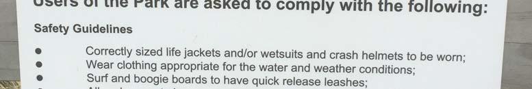
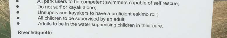


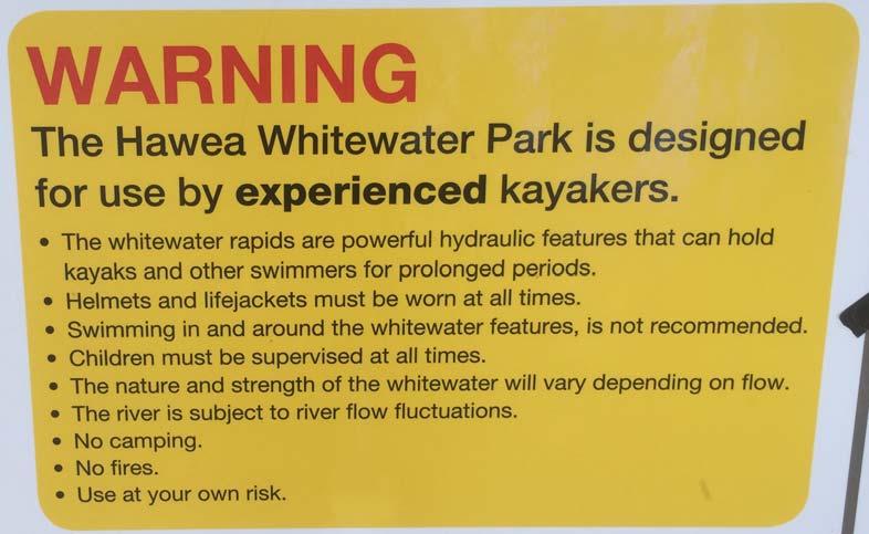
49 Klondyke White Water Course management plan consultation draft RG&A 8 DRAFT
50 2 Status of activity The wave feature is likely to operate as no more than a grade 2 white water feature, defined as (for kayaking): Easy rapids with waves of up to one metre. Clear channels obvious without scouting. The ability to move your craft across the current is not necessary. (Charles, G NZ Whitewater 5) Waves breaking white but without obstacles in the flow so does not require any degree of boat handling skills. (Egarr, G South Island Rivers) The defining characteristics for the Course, in terms of grade, are the size of the standing wave and the lack of obstacles. The WWC is intended to operate as a public aquatic facility, defined by the NZ Recreation Association s (NZRA) Aquatic Facility Guidelines (2015) as: A public aquatic facility means any pool other than domestic pools. This category includes commercial, school, institutional, club, hospitality industry, community and local authority pools. This definition does not differentiate between local authority, community, trust, school or private facility ownership. The WWC is likely to be a unique aquatic offering in New Zealand, and the intention is to operate it, most of the time, as a community facility without lifeguards. This management plan therefore treats the Course in a similar manner to a school pool which is made available to a community over summer, unless commercial or community events are staged, when an event-specific safety management plan will be required (most likely requiring lifeguards). The NZRA Aquatic Facility Guidelines have been used for the development of this draft management plan, but are interpreted for what would be an unusual and exciting community aquatic asset. DRAFT The Course may be considered as an Adventure Activity as per the Regulation 4 of the Health and Safety in Employment (Adventure Activities) Regulations 2011 where it meets certain requirements. These are, according to WorkSafe NZ 1 : An adventure activity is: an activity that is paid for and land-based or water-based (planes, helicopters, and hot air balloons are not included but, for example, the skiing aspect of heli-skiing is included because it is a landbased activity) and an activity that involves the participant being guided, taught how, or assisted to participate in the activity and recreational or educational and 1 Klondyke White Water Course management plan consultation draft RG&A 9
51 designed to deliberately expose the participant to a risk of serious harm that must be managed by the provider of the activity and an activity that, if the provider fails to manage the activity properly, is likely to result in serious harm to the participant or an activity in which the participant is deliberately exposed to dangerous terrain or dangerous waters. By maintaining the flow of the Course so that it does not exceed a grade 2 white water setting (no obstacles and a wave of less than 1 m), compliance with the Health and Safety in Employment (Adventure Activities) Regulations 2011 will not be required when it is used by the non-paying public (it is not considered to be dangerous waters ). If a commercial operator or event manager wishes to use the facility and charge for use, or if any group or agency wishes to operate the Course at more than grade 2 (ie, a wave higher than 1 m), compliance with the Regulations will be required. Applications for such use will be at the discretion of the administering authority (defined below) and work to ensure compliance will be the responsibility of the applicant. The Canterbury Regional Council Navigation Safety Bylaw 2016 and Controls would apply to the course where kayaks, surf and stand-up-paddle boards are used. In these cases, the course will be considered navigable waters, and the Maritime Rules (particularly section 91 Navigation Safety) would also apply. In the case of the WWC, this will include the need for buoyancy aids to be worn by kayakers, which is mandatory under the 2016 Bylaw; and that while riders of SUPs do not need to wear a life jacket while surfing a breaking wave, they are required to wear a leg rope (under Exemption 097-EX-143 to Maritime Rule 91.4 which is valid until the end of June 2018). The Rules and Bylaw do not include consideration of whether the Course should be fenced, for example, and only apply to the use of defined watercraft. DRAFT Klondyke White Water Course management plan consultation draft RG&A 10
52 3 Risks analysis This section identifies the hazards and risks likely to be associated with the WWC, considering the activities likely to occur in and near the facility. Activities which may result in death are rated as having a high risk. Responses to minimise the potential for harm are identified, and responsible agencies proposed. The responses and responsibilities, in particular, inform the remainder of this draft Plan. Table 1: Risk analysis Activity Hazard Risk Responses Responsibilities Parking cars and the public accessing the site by car Vehicle on vehicle, vehicle on pedestrian, and vehicle on object collisions. Moderate Speed restrictions and appropriate signs on Shepherds Bush Road. Speed bumps on Shepherds Bush Road if necessary. Car park design for safe use while restricting ability to do burn-outs. Fencing of activity area to separate facility users from cars. ADC for appropriate road control bylaw and pedestrian warning and speed signs. Remainder in project design. Use of ablutions changing, toilets. Located outside fenced facility to allow general public use. Infection from unsanitary conditions Antisocial behaviour and inappropriate use Moderate Programmed cleaning schedule. User reporting information on site. Programmed inspections. Moderate Natural lighting only to dissuade use after dark. Project design. User induction programme no solo use (group surveillance). Contractor under direction of administering agency. ADC on behalf of administering agency. Access to waterbodies outside amenity area Slips and falls, injuries from damaged building components Drowning in water storage pond Moderate Appropriate building design. Project design. High Scheduled building inspections. Warning signs. Fully fenced with signs. Trespass notices. DRAFT Drowning in irrigation canal High Fenced on true left from pond outlet to 20 metres beyond feature low fence to allow emergency access. Signs (no access to canal). Trespass notices. Contractor under direction of administering agency. Administering agency. RDRML RDRML Klondyke White Water Course management plan consultation draft RG&A 11
53 Table 1: Risk analysis Activity Hazard Risk Responses Responsibilities Use of grassed area within fenced facility. Picnics, spectating, waiting, surveillance. Antisocial behaviour and inappropriate use Potential to fall in section of moving water or pool above Moderate High Recorded webcam User induction programme no solo use (group surveillance). Digital key entry (recorded user). Trespass notices. Barriers beside white water section and on sides of upper pool (entry only from the top end of the course). Open entry and exit from exit pool. ADC on behalf of administering agency. Administering agency. Project design. Litter, broken glass. Low Electronic surveillance (recorded webcam) User induction programme no solo use (group surveillance). Take home rubbish policy (no bins). ADC on behalf of administering agency. Administering agency (signs). Use of still water areas for swimming, waiting and exiting. Slips and falls Moderate Facility design. Steps. Project design. Facility maintenance (slime, grit). Drowning in still water High User induction programme no solo use (group surveillance). Digital key entry (recorded user) Contractor under direction of administering agency. ADC on behalf of administering agency. Rules and signs: No casual swimming upstream of marked line to reduce risk of collision. No swimming when kayaks are in use. No free swimming (buoyancy aids required). Rules to manage crowding and inter-activity conflict. Emergency buoyancy aid on site. PoolSafe age limits. Potential to restrict pool use to only entry and exit for white water feature (no casual swimming). Emergency response procedures information on site. NZRA PoolSafe audits. DRAFT Administering authority. Klondyke White Water Course management plan consultation draft RG&A 12
54 Table 1: Risk analysis Activity Hazard Risk Responses Responsibilities Emergency phone on site. Emergency flow shut-off. Automatic flow shut-down 30 minutes before sunset (no use in low light). Within Vodafone and Spark mobile coverage area. Project design, administering authority. To note. Broken glass, litter in pools Low Facility inspection. Contractor under direction of administering agency. User induction programme (self-check). ADC on behalf of administering agency. Pinning and drowning in flow discharge structure Illness from contact with contaminated water Antisocial behaviour and inappropriate use High Structure design. Project design. As for drowning in still water. As for use of white water section. Low Continuous flushing of water feature. Project design. Testing of water quality. RDRML via Water Quality Monitoring Plan Moderate As for Use of grassed area. Use of white water section Head injury from striking concrete walls or bottom High User induction programme rules and risk awareness. ADC on behalf of administering agency. Signs and rules: Helmets required for kayaking. No other standing activities permitted without helmets (surfing, SUP). No free swimming (buoyancy aid must be used at all times). Leg ropes required for surf boards and SUPs to reduce the chance of other users being struck. DRAFT Administering authority. Klondyke White Water Course management plan consultation draft RG&A 13
55 Table 1: Risk analysis Activity Hazard Risk Responses Responsibilities Maintaining flow at a maximum of grade 2 for general use. Compliance with Health and Safety in Employment (Adventure Activities) Regulations 2011 for higher grade flows. Administering authority, with applicant for flows above grade 2 or otherwise when Health and Safety in Employment (Adventure Activities) Regulations 2011 apply. Drowning after immersion and/or injury. High Signs and rules: Flotation devices required for all wave activities. Administering authority. As for drowning in still water. Congestion and conflict between users. Moderate Clock to show half hour blocks of exclusive use for kayaks and other users if they are present at the same time. Administering authority. Appropriate rules for use, with maximum numbers of simultaneous users of the feature stated. Events and booked community or commercial uses. Injury or death during staged commercial or community events any cause. Varies Event and activity-specific health and safety plan reviewed and agreed. All events and booked activities to have life guards. Administering authority (proposal review, contractual agreement), independent event manager or activity operator. Compliance with Adventure Activity Regulations 2011 and other relevant legislation. Independent event manager or activity operator (where applicable). DRAFT Klondyke White Water Course management plan consultation draft RG&A 14
56 4 Proposed administration Several responsible agencies are proposed in the risk analysis. Ultimate responsibility will lie with an appropriate administering authority, proposed here to be an incorporated society that is established by RDRML prior to the Pond being developed. However, RDRML will hold the consents for the Course and be responsible for ensuring compliance. Should any of the named parties in this section not be interested in supporting the proposal via the suggested roles, ensuring those roles are fulfilled will remain the responsibility of RDRML and the administering authority. 4.1 Administering authority The administering authority is proposed to be responsible for: Asset ownership and funding, Project design and implementation, Completion of the final WWC management plan, including user induction package and process, Asset inspections, cleaning and maintenance (via contract), Asset operation (via contract or agreement) and operation protocols, Setting user rules, User information services and signage, including a live webcam of the Course and the publication online of, for example, flow availability data and when the course is booked for exclusive use, Asset surveillance (via contract or agreement), Coordination of all other services associated with the WWC via relationships with other agencies, particularly the Ashburton District Council and the RDRML particularly in relation to flow availability for the latter (discussed in more detail for each agency below), Approving event proposals and commercial use agreements, Setting preferred flows, either via a set schedule or by request, Communicating with users via the user database, Issuing trespass notices to the lease area if required, Managing and implementing PoolSafe assessments, noting that these would need interpretation for the WWC, Liaising with users to define preferred water flows, Annual review of this Management Plan, and its update as required, Inducting users to the facility, Issuing keys and refunding deposits on their return, Maintaining a database of inducted users and supplying a contact list to the administering authority, Ensuring flows have ceased when necessary (before dusk, for example), Responding to emergency contacts via the on-site emergency contact system (automatic warning when the emergency flow stop is activated), Managing an incident and accident register (with reporting required by users as part of the induction agreement), DRAFT Klondyke White Water Course management plan consultation draft RG&A 15
57 Working with the Ashburton District Council to manage local road bylaws to restrict vehicle speed on Shepherds Bush Road and to install relevant speed and pedestrian presence signs. Administering the authority as an incorporated society. An incorporated society is, according to the Companies Office: a group or organisation that has been registered under the Incorporated Societies Act 1908 and, when incorporated, is authorised by law to run its affairs as though it were an individual person. This means that the members are not personally liable for the society's debts, contracts or other obligations. Likewise, members do not have any personal interest in any property or assets owned by the society. An incorporated society must have a minimum of 15 members and will require a committee and rules. Members are proposed to be drawn from, at least initially, RDRML, Mayfield and District Citizens Association, Ashburton District Council and Experience Mid Canterbury. Invitations for membership will be made to White Water New Zealand, local schools and local adventure operators. A charitable trust is another option, but surplus assets must be distributed to other charitable organisations on its wind-up. An event can be defined as any: Use of the WWC that includes a payment for a service or access, Use by an educational institution, Party of more than 15 people, Exclusive use. 4.2 Rangitata Diversion Race Management Ltd RDRML will own the land upon which the WWC will be constructed and will lease the land to the administering authority of the WWC at a peppercorn rental. RDRML will also be responsible for ensuring compliance with the consent conditions which apply to the Course. DRAFT The WWC will rely on water from the Klondyke Storage Pond and the administering authority will not be able to control the quality of the water, which may be affected by bird droppings and/or other effects of storage. RDRML will be responsible for providing water into the course and managing the diversion control gates, as these will be an RDRML asset. However, RDRML will not be responsible for deciding on the flows required within the Course, which will be identified and requested by the administering authority (or it delegate). RDRML will be responsible for: Water quality testing in the pond discharge via the Water Quality Monitoring Plan and reporting any exceedances of relevant contact recreation water standards, Supply of flow availability data and reporting these online for Course users and managers, Operation of the flow diversion gates (inflow and outlet) at the request of the administering authority (or their delegate), Fencing of water and fall hazards near the Course and on accessible RDRML land, Installation of appropriate warning signs for hazards on accessible RDRML land, Issuing trespass notices for areas not associated with the lease. Klondyke White Water Course management plan consultation draft RG&A 16
58 4.3 Ashburton District Council, Mayfield and District Citizens Association and Experience Mid Canterbury The Ashburton District Council, Mayfield and District Citizens Association and Experience Mid Canterbury would assist in ensuring the Course is appropriately managed and promoted for the benefit of locals and visitors to the District via engagement with the administering authority as, potentially, members of the incorporated society. DRAFT Klondyke White Water Course management plan consultation draft RG&A 17
59 5 Course management It is likely that a permanent part-time facility manager will be required, and employed by the administering authority. The authority would be responsible for ensuring the following operational facilities and services are implemented (as well as all items listed in section 4.1). 5.1 Facilities The proposed design of the WWC is shown in Appendix 1. Components of the Course not shown and required for the management of the Course will include: Fencing and electronic entry gate with digital recording of the key number, Webcam (recorded but not actively monitored, live online), Emergency flow shut-off system with automatic notification to EA Networks Centre and RDRML, Time-use allocation clock for different activities, Pool depth markings, Website with rules of use, induction requirements, contacts and live webcam during the season, Signs and warnings. Artificial lighting is not proposed so as to discourage night use. 5.2 Access Use of the facility will be limited to groups of people who must have one member who has been inducted into use of the Course, and has a key to the facility (the responsible user ). Key use will be recorded and the responsible user will agree to ensuring group compliance with the Course rules. Keys will expire annually and a deposit will be refunded on their return. Induction will need to be carried out annually. DRAFT The responsible user must be aged 20 or over and may be responsible for a maximum group size of eight other people, only three of whom may be aged under Flow setting The inflow control gate will define how much water enters the course and the position and size of the wave. The required flow rates are not yet defined and will likely require some experimentation, but the desired outcome will be a grade 2 water feature for general public use as discussed in section 2 of this draft Plan, and higher grades on request and with an appropriate event or userspecific safety management plan in place in accord with the Health and Safety in Employment (Adventure Activities) Regulations 2011 and other relevant legislation. RDRML will be responsible for the management of the control gates as this will remain its asset, and will deliver flows as requested by the administering authority which will generally be the defined flow for a grade 2 feature. Any change in flow (operation of the control gate) will be marked by a flashing light and siren. 5.4 Supervision Supervision for general public use will be the responsibility of the responsible person. PoolSafe signage will be used which normally requires for all children under 8 must be actively supervised by a caregiver 16 or over. Klondyke White Water Course management plan consultation draft RG&A 18
60 During commercial events or other paid use, and when the site is operating as a workplace, supervision will be according to a specific activity management plan which will include supervision via either a lifeguard or suitably trained service provider (such as a kayak coach or appointed club member). 5.5 Rules and warnings Rules will include (and will form part of the induction package): Induction requirements as above, with the onus for compliance placed on the responsible user, Age restrictions as above, Helmet required for kayaks, SUPs and other stand-up activities, Buoyancy aids for all users, Exclusive use for kayaks with time limits when other users are present and the Course has not been exclusively booked, Time limits on access, partly enforced by automatic close of control gates before dusk. Signs will be mounted to state those rules, plus: Trespass notices for those not accompanied by a responsible user, Reminder of the onus on the responsible user, PoolSafe warning signs, Shared use rules and maximum use limits, Requirement to exit the course when the control gate siren and light operate (possible flow change), Notices regarding the recorded surveillance in operation, Emergency response information (use of a 111 call), Operating instructions for emergency control gate closure and emergency communications. DRAFT 5.6 Emergency management and responses Emergency management and prevention protocols will include: Course familiarisation visits and refreshers for police, ambulance and fire, with access keys issued to all agencies (otherwise bolt cutters would work), Notification to emergency response agencies (111) as to the location, function and emergency operation and contacts for the Course, Annual induction process for users (the responsible person ), Communications with inducted users via a digital newsletter (safety reminders) and periodic direct survey of users, Incident and accident recording (a requirement of the induction), Recording of key use, assignment of that key to the one responsible person allowing access to their contact details. Emergency responses will include: Closure of control gates via on-site or remote operation, Automatic warning of gate operation to RDRML and EA Network Centre and the ability to see events onsite via the webcam, Klondyke White Water Course management plan consultation draft RG&A 19
61 Emergency response via 111 (user first, RDRML and EA Network Centre as backup). 5.7 Maintenance and audit The final course design will define a list of specific assets which will require audit, and the frequency of checks. This would include, for example, exposure of any items which may lead to puncture wounds or electric shock, unauthorised access, the legibility of signs, and the functioning of emergency devices and the webcam. Maintenance contracts for the ablutions will need to be specified. Consent conditions require monitoring and reporting of water quality by RDRML. Depending on flow conditions, the course itself is likely to need periodic draining and removal of grit and algae, particularly if they create slip hazards. DRAFT Klondyke White Water Course management plan consultation draft RG&A 20

62 Appendix 1: Preliminary course design DRAFT 6 Klondyke White Water Course management plan consultation draft RG&A 21
63 Klondyke White Water Course management plan consultation draft RG&A 22 DRAFT
64 7 Appendix 1: NZRA Peer Review summary DRAFT Klondyke White Water Course management plan consultation draft RG&A 23

65 Draft Klondyke White Water Course Management Plan Peer Review Deb Hurdle, National Project Manager New Zealand Recreation Association
Before the Canterbury Regional Council and the Ashburton District Council. In the matter of the Resource Management Act 1991
 Before the Canterbury Regional Council and the Ashburton District Council In the matter of the Resource Management Act 1991 And In the matter of The Rangitata Diversion Race Management Limited Consents
Graeme Wilson Vice President, Whitewater NZ & Vice President, Whitewater Canoe Club
 Graeme Wilson Vice President, Whitewater NZ & Vice President, Whitewater Canoe Club May 2011 Formerly NZ Recreational Canoeing Association National body for kayaking and canoeing Principal activities are
Presentation to the Hurunui Waiau Zone Committee
 Presentation to the Hurunui Waiau Zone Committee Ian Fox Committee Member, Whitewater Canoe Club (WWCC) Graeme Wilson Vice President, Whitewater NZ & Vice President, WWCC October 2010 WWCC has around 200
Update June 2018 OUR 2017 PUBLIC ENGAGEMENT
 Update June 2018 Hi, Let s Get Wellington Moving (LGWM) is developing a Recommended Programme of Investment (RPI) that meets our programme objectives and supports the city s and region s growth. As part
IN THE MATTER of the Resource Management Act 1991
 IN THE MATTER of the Resource Management Act 1991 AND IN THE MATTER of applications for resource consent by the Central Plains Water Trust and a notice of requirement for the designation of land by Central
* 1 I am a person representing a relevant aspect of the public interest; or
 Further Submission on The Greater Wellington Natural Resources Plan Review. Please complete this form to make a further submission on the Proposed Natural Resources Plan for the Wellington Region (PNRP).
The primary purpose of the TFF is to help promote a healthy farm tenanted sector in Scotland. It aims to fulfil this purpose by:
 T e n a n t F a r m i n g F o r u m S u b m i s s i o n o f E v i d e n c e t o t h e L a n d R e f o r m R e v i e w G r o u p I N T R O D U C T I O N The Tenant Farming Forum (TFF) is a membership organisation
Service Business Plan
 Service Business Plan Service Name Transportation Planning Service Type Public Service Owner Name Kaylan Edgcumbe Budget Year 2019 Service Owner Title Service Description Manager of Transportation Planning
Environment Canterbury
 1 Before the Hearings Commissioners at Christchurch in the matter of: to: submitter: a submission on the proposed Hurunui and Waiau River Regional Plan and Plan Change 3 to the Natural Resources Regional
Ministry of Forests, Lands, and Natural Resource Operations OVERVIEW OF ANGLING MANAGEMENT PLANS FOR THE SKEENA WATERSHED
 Ministry of Forests, Lands, and Natural Resource Operations OVERVIEW OF ANGLING MANAGEMENT PLANS FOR THE SKEENA WATERSHED November 19, 2013 1.0 Intent of this Document This overview provides background
* 1 I am a person representing a relevant aspect of the public interest; or
 Further Submission on The Greater Wellington Natural Resources Plan Review. Please complete this form to make a further submission on the Proposed Natural Resources Plan for the Wellington Region (PNRP).
Guidance Note. Hydropower Guidance Note: HGN 8 Fish Passage. When do you need to install a fish pass?
 Guidance Note Hydropower Guidance Note: This guidance note is not intended as a statement of law. It should be read in combination with, and in the context of, the relevant enactments and EU obligations.
The Scottish Open Water Swimming Association
 Introducing The Scottish Open Water Swimming Association We are pleased to present draft documents for general consultation of the proposed new charity, the Scottish Open Water Swimming Society. We invite
Salmon Five Point Approach restoring salmon in England
 Salmon Five Point Approach restoring salmon in England Our Mission To restore the abundance, diversity and resilience of salmon stocks throughout England We will do this by:- a) Maximising the production
Local Government Road Safety Summit - 9 April 2018
 Local Government Road Safety Summit - 9 April 2018 Report on outcomes The Associate Minister of Transport, Hon Julie Anne Genter held the Local Government Road Safety Summit in Wellington on 9 April 2018.
PAEKĀKĀRIKI HILL ROAD / BEACH ROAD / SH1 INTERSECTION PROGRESS REPORT
 Chairperson and Committee Members ENVIRONMENT AND COMMUNITY DEVELOPMENT COMMITTEE 6 DECEMBER 2011 Meeting Status: Public Purpose of Report: For Decision PAEKĀKĀRIKI HILL ROAD / BEACH ROAD / SH1 INTERSECTION
CAIRNGORMS NATIONAL PARK AUTHORITY FOR DECISION
 CAIRNGORMS NATIONAL PARK AUTHORITY FOR DECISION Title: Prepared by: A9 Dualling Project: Dalraddy to Slochd Murray Ferguson, Director of Planning and Rural Development and Gavin Miles, Head of Planning
Cycle journeys on the Anderston-Argyle Street footbridge: a descriptive analysis. Karen McPherson. Glasgow Centre for Population Health
 Cycle journeys on the Anderston-Argyle Street footbridge: a descriptive analysis Karen McPherson Glasgow Centre for Population Health March 2017 Key points: There were 116,334 cycle journeys made using
Secretary Game Animal Panel PO Box 9134 Addington CHRISTCHURCH 8243
 Date: Secretary Game Animal Panel PO Box 9134 Addington CHRISTCHURCH 8243 RE: SUBMISSION TO THE DISCUSSION DOCUMENT MANAGING NUMBERS OF DEER, CHAMOIS, TAHR AND PIGS As a private individual who actively
Statement of Evidence of Judith Makinson
 In the Matter of: The Resource Management Act 1991 and In the Matter of: Podium Sports Lodge, 18 20 Peake Road Application By: Brian Perry Charitable Trust Statement of Evidence of Judith Makinson TDG
Schedule for Culvert Works in or on the Bed or Bank of a Watercourse PLEASE READ THIS PAGE BEFORE COMPLETING THE APPLICATION FORM
 10A Schedule for Culvert Works in or on the Bed or Bank of a Watercourse This form is to be used for applications to use, erect, place, extend, alter or replace a culvert in or on the beds or banks of
Council CNL(17)33. Annual Progress Report on Actions Taken Under the Implementation Plan for the Calendar Year EU - Denmark
33. Annual Progress Report on Actions Taken Under the Implementation Plan for the Calendar Year EU - Denmark") Agenda item 6.3 For information Council CNL(17)33 Annual Progress Report on Actions Taken Under the Implementation Plan for the Calendar Year 2016 EU - Denmark CNL(17)33 Annual Progress Report on Actions
Agenda item 6.3 For information Council CNL(17)33 Annual Progress Report on Actions Taken Under the Implementation Plan for the Calendar Year 2016 EU - Denmark CNL(17)33 Annual Progress Report on Actions
PRESENTATION TO THE BRITISH COLUMBIA LEGISALTIVE STANDING COMMITTEE ON FINANCE September 26, 2013
 PRESENTATION TO THE BRITISH COLUMBIA LEGISALTIVE STANDING COMMITTEE ON FINANCE September 26, 2013 On behalf of its 40,000 plus members, The BC Wildlife Federation welcomes the opportunity to address the
The approach of CanoeKayak BC Whitewater (CKBC-WW) to River Access issues is driven by the organizational Mission Statement:
 to River Access issues is driven by the organizational Mission Statement:") CanoeKayak BC - Whitewater DRAFT RIVER ACCESS POLICY For Comment The approach of CanoeKayak BC Whitewater (CKBC-WW) to River Access issues is driven by the organizational Mission Statement: Provide structure
CanoeKayak BC - Whitewater DRAFT RIVER ACCESS POLICY For Comment The approach of CanoeKayak BC Whitewater (CKBC-WW) to River Access issues is driven by the organizational Mission Statement: Provide structure
ONE SIZE DOESN T FIT ALL RECONCILING OVERLAPPING TRANSPORT NETWORKS IN A CONSTRAINED URBAN ENVIRONMENT
 One Size Doesn t Fit All S Corbett, C Chenery Page 1 ONE SIZE DOESN T FIT ALL RECONCILING OVERLAPPING TRANSPORT NETWORKS IN A CONSTRAINED URBAN ENVIRONMENT Authors/Presenters: Sam Corbett, Principal Transport
Developing a programme to make Taranaki predator-free
 Factsheet: 6 Developing a programme to make Taranaki predator-free The Taranaki Regional Council wants to initiate an innovative change in managing predators to benefit our native plants and wildlife,
Public Consultation Document
 Environment and Climate Change Canada Public Consultation Document From February 22 to March 21, 2018 Canadian Wildlife Service PROPOSED SERVICE FEES FOR THE MIGRATORY GAME BIRD HUNTING PERMIT AND CANADIAN
BEFORE THE ENVIRONMENT COURT
 1991 BEFORE THE ENVIRONMENT COURT I MUA I TE KOOTI TAIAO O AOTEAROA ENV-2018-AKL-000078 Under the Resource Management Act 1991 ( the Act ) In the matter of a direct referral of an application for resource
IN THE MATTER of the Resource Management Act 1991
 IN THE MATTER of the Resource Management Act 1991 AND IN THE MATTER of an application pursuant to Section 201 for a Water Conservation Order on the Hurunui River. STATEMENT OF REBUTTAL EVIDENCE OF DAVOR
SA New Trial Artificial Reef Project
 BACKGROUND PAPER SA New Trial Artificial Reef Project Development of options for the trial artificial reef 1. Summary CONTENTS Each year, an estimated 236,000 South Australians participate in recreational
Please find attached the City Council's further submission on PC4 LWRP.
 From: To: Subject: Date: Attachments: Kingsbury, Peter Mailroom Mailbox PC4 plwrp Further Submission Tuesday, 17 November 2015 1:03:24 p.m. CCC further submission on ECan s LWRP PC4. Land and Water Regional
THE PROPOSED NETWORK RAIL (ESSEX AND OTHERS LEVEL CROSSING REDUCTION) ORDER DEPARTMENT FOR TRANSPORT REFERENCE: TWA/17/APP/05
 ORDER DEPARTMENT FOR TRANSPORT REFERENCE: TWA/17/APP/05") OBJ/148/W 003 H05 PATTENS CROSSING THE PROPOSED NETWORK RAIL (ESSEX AND OTHERS LEVEL CROSSING REDUCTION) ORDER PUBLIC INQUIRY, 18 OCTOBER 2017 DEPARTMENT FOR TRANSPORT REFERENCE: TWA/17/APP/05 OBJECTION
OBJ/148/W 003 H05 PATTENS CROSSING THE PROPOSED NETWORK RAIL (ESSEX AND OTHERS LEVEL CROSSING REDUCTION) ORDER PUBLIC INQUIRY, 18 OCTOBER 2017 DEPARTMENT FOR TRANSPORT REFERENCE: TWA/17/APP/05 OBJECTION
QLDC Council 29 October Report for Agenda Item: 3
 QLDC Council 29 October 2015 Department: Infrastructure Beach Street Pedestrianisation Purpose Report for Agenda Item: 3 1 The purpose of this report is to obtain Council approval to consult over options
WANAKA SWIMMING FACILITIES STATEMENT OF PROPOSAL
 WANAKA SWIMMING FACILITIES STATEMENT OF PROPOSAL 17 October 2014 Contents Executive Summary Background National Guidelines The Status Quo Issue One Timing Issue Two Location Issue Three Size Issue Four
Thank you for the opportunity to comment on the Draft Freshwater Fisheries Management Plan on behalf of Victoria s recreational fishing sector.
 Anthony Forster Inland Fisheries Manager Victorian Fisheries Authority By email: Anthony.Forster@vfa.vic.gov.au DRAFT FRESHWATER FISHERIES MANAGEMENT PLAN Dear Anthony, Thank you for the opportunity to
Section 2 Strategic Alignment. Contents
 Section 2 Strategic Alignment Contents 2 Strategic Alignment... 2 2.1 General... 2 2.2 SmartGrowth Strategy and Implementation Plan... 2 2.3 Walking and Cycling Strategy... 3 2.4 Built Environment Strategy...
INTERIM ADVICE NOTE 150/12. Guidance for Alternative Temporary Traffic Management Techniques for Relaxation Schemes on Dual Carriageways.
 INTERIM ADVICE NOTE 150/12 Guidance for Alternative Temporary Traffic Management Techniques for Relaxation Schemes on Dual Carriageways Summary Guidance for temporary traffic management (TTM), on the approach
Submission on the proposed New Zealand Coastal Policy Statement 2008 Sections 49 and 57 of the Resource Management Act 1991
 Submission on the proposed New Zealand Coastal Policy Statement 2008 Sections 49 and 57 of the Resource Management Act 1991 To: Board of Inquiry Proposed NZCPS C/- Department of Conservation PO Box 10
Recreational Uses of St Marys Bay and Masefield Beach Panuku Development Auckland
 Appendix D Recreational Uses of St Marys Bay and Masefield Beach Panuku Development Auckland Beca // 2 May 2018 4216571 // NZ1-15242655-52 0.52 // page 133 Recreational uses of St Marys Bay and Masefield
High level Peer Review on the Around the Mountain Cycle Track Reports (Oreti/Mararoa Route Options)
") High level Peer Review on the Around the Mountain Cycle Track Reports (Oreti/Mararoa Route Options) Conducted for Marcus Roy Resource Management Planner, Southland District Council High level Peer Review,
High level Peer Review on the Around the Mountain Cycle Track Reports (Oreti/Mararoa Route Options) Conducted for Marcus Roy Resource Management Planner, Southland District Council High level Peer Review,
MINISTRY OF ENVIRONMENT ENVIRONMENTAL STEWARDSHIP DIVISION FISH AND WILDLIFE BRANCH. Horsefly River Angling Management Plan
 MINISTRY OF ENVIRONMENT ENVIRONMENTAL STEWARDSHIP DIVISION FISH AND WILDLIFE BRANCH Horsefly River Angling Management Plan January 30 th, 2006 Area/Fishery Description The Horsefly River watershed provides
Loughs Agency Gníomhaireacht na Lochanna Factrie fur Loughs
 CONSULTATION DOCUMENT PROPOSED AMENDMENTS OF THE FOYLE AREA (CONTROL OF FISHING) REGULATIONS 1999 Foyle Area (Control of Fishing) (Amendment) Regulations 2008 INTRODUCTION This Consultation Document sets
Active Travel Strategy Dumfries and Galloway
 Active Travel Strategy Dumfries and Galloway Our Active Travel Strategy The agreed Interventions for Dumfries and Galloway Council s Local Transport Strategy includes an action to Develop an Active Travel
CONTENTS PREFACE 1.0 INTRODUCTION AND SCOPE 2.0 POLICY AND GOVERNANCE 3.0 SUMMARY OF PROGRESS 4.0 NATURE OF DEMAND 5.0 TRAVEL AND PARKING INITIATIVES
 CONTENTS PREFACE 1.0 INTRODUCTION AND SCOPE 2.0 POLICY AND GOVERNANCE 3.0 SUMMARY OF PROGRESS 4.0 NATURE OF DEMAND 5.0 TRAVEL AND PARKING INITIATIVES 6.0. TARGETS PREFACE The University of St Andrews has
Summary of Proposal to Upgrade Swimming Facilities for the Wanaka Ward
 Attachment B Summary of Proposal to Upgrade Swimming Facilities for the Wanaka Ward Introduction The Queenstown Lakes District Council is proposing to build an eight lane lap pool and a learners pool costing
Regional Cycle Programme Update
 Agenda Item 10 (ii) Regional Cycle Programme Update Glossary Auckland Council Auckland Transport Cycle Action Auckland New Zealand Transport Agency Regional Cycle Network (AC) (AT) (CAA) (NZTA) (RCN) Executive
THE PLANNING AND. Transport and the law Integrated transport planning Strategies Responsibilities of local government and road controlling authorities
 The planning and policy context Transport and the law Integrated transport planning Strategies Responsibilities of local government and road controlling authorities THE PLANNING AND POLICY CONTEXT Providing
Wellington Public Transport Spine Study
 Wellington Public Transport Spine Study Study purpose Feasibility study Options for a high quality, high frequency PT system Key action from Ngauranga to Airport Corridor Plan (2008) Long-term outlook
Walking and Cycling Action Plan Summary. A Catalyst for Change The Regional Transport Strategy for the west of Scotland
 Walking and Cycling Action Plan Summary A Catalyst for Change The Regional Transport Strategy for the west of Scotland 2007-2021 Strathclyde Partnership for Transport Contents Purpose...2 Issues, Constraints
ICC REGULATIONS FOR THE REVIEW OF BOWLERS REPORTED WITH SUSPECT ILLEGAL BOWLING ACTIONS
 ICC REGULATIONS FOR THE REVIEW OF BOWLERS REPORTED WITH SUSPECT ILLEGAL BOWLING ACTIONS ICC REGULATIONS FOR THE REVIEW OF BOWLERS WITH SUSPECTED ILLEGAL BOWLING ACTIONS DEFINITIONS In these Illegal Bowling
The Economic Importance of Recreational River Use to the City of Calgary
 The Economic Importance of Recreational River Use to the City of Calgary Prepared by: Calgary River Users Alliance May 20, 2016 The Economic Importance of Recreational River Use to the City of Calgary
APPENDIX 11 WIND EFFECTS ASSESSMENT
 APPENDIX 11 WIND EFFECTS ASSESSMENT Summerset Villages (Lower Hutt) Ltd District Plan Change Request Prepared by Urban Perspectives Ltd 17 September 2014 341 49 342 Opus Research Report 14-529D84.00 Wind
APPELLANT S STATEMENT OF CASE
 TOWN & COUNTRY PLANNING ACT 1990 (AS AMENDED) APPEAL BY FOCUS INTERNATIONAL CHRISTIAN CENTRE (FICC) AGAINST REFUSAL OF PLANNING PERMISSION BY THE LONDON BOROUGH OF HILLINGDON PLANNING PERMISSION IS SOUGHT
Appendix 7: Fisheries Management
 Appendix 7: Fisheries Management 1. Introduction 2. Whitebait The roles and responsibilities of central and local authorities regarding the current management of the Waikato River fisheries are encompassed
TO: Board Members Vancouver Park Board FROM: General Manager Parks and Recreation SUBJECT: Seaside Greenway Improvements
 Date: October 1, 2013 TO: Board Members Vancouver Park Board FROM: General Manager Parks and Recreation SUBJECT: Seaside Greenway Improvements RECOMMENDATION A. THAT the Board approve the new bike paths
Styal Golf Course Accommodation Works Environmental Statement Non-Technical Summary 1007/6.15.2/169
 Styal Golf Course Accommodation Works Non-Technical Summary 1007/6.15.2/169 September 2013 Document Control Sheet Project Title: Styal Golf Course Report Title: Non Technical Summary Document No: 1032775.014.001
Standard Operating Policy and Procedures (SOPP) 3:
 3:") Standard Operating Policy and Procedures (SOPP) 3: INITIAL AND CONTINUING REVIEW BY THE IRB: REQUIREMENTS FOR SUBMISSION OF APPLICATIONS, APPROVAL CRITERIA, EXPEDITED AND CONVENED COMMITTEE REVIEW AND
Standard Operating Policy and Procedures (SOPP) 3: INITIAL AND CONTINUING REVIEW BY THE IRB: REQUIREMENTS FOR SUBMISSION OF APPLICATIONS, APPROVAL CRITERIA, EXPEDITED AND CONVENED COMMITTEE REVIEW AND
Cycle traffic and the Strategic Road Network. Sandra Brown, Team Leader, Safer Roads- Design
 Cycle traffic and the Strategic Road Network Sandra Brown, Team Leader, Safer Roads- Design Highways England A Government owned Strategic Highways Company Department for Transport Road Investment Strategy
GD 0043/18 ACTIVE TRAVEL STRATEGY
 GD 0043/18 ACTIVE TRAVEL STRATEGY 2018-2021 May 2018 Minister s Introduction There is strong evidence that regular physical activity reduces the risk of a range of health conditions. The best way to increase
Anglers Notice Review
 Anglers Notice Review Introduction Otago Fish and Game Council is seeking information and view from anglers as part of a comprehensive review of the freshwater sports fishing Regulations (Anglers Notice)
COUNCIL POLICY NAME: COUNCIL REFERENCE: 06/119 06/377 09/1C 10llC 12/1C INDEX REFERENCE: POLICY BACKGROUND
 COUNCIL POLICY NAME: COUNCIL ADVISORY COMMITTEES - TERMS OF REFERENCE ISSUED: APRIL 3, 2006 AMENDED: NOVEMBER 27, 2006 NOVEMBER 23, 2009 JANUARY 11, 2010 DECEMBER 17, 2012 POLICY COUNCIL REFERENCE: 06/119
Berwick Health and Education Precinct: Casey Amendment C207 (Part 1) Submission to Planning Panels Victoria
 Submission to Planning Panels Victoria") Berwick Health and Education Precinct: Casey Amendment C207 (Part 1) Submission to Planning Panels Victoria August 2018 CONTENTS 1 Executive summary... 1 2 Summary of the amendment... 2 3 Submission...
Berwick Health and Education Precinct: Casey Amendment C207 (Part 1) Submission to Planning Panels Victoria August 2018 CONTENTS 1 Executive summary... 1 2 Summary of the amendment... 2 3 Submission...
MOVING TO RIGHTS BASED MANAGEMENT: GREEN-LIPPED MUSSEL CASE STUDY. Martin Workman, Ministry of Fisheries, New Zealand,
 MOVING TO RIGHTS BASED MANAGEMENT: GREEN-LIPPED MUSSEL CASE STUDY Martin Workman, Ministry of Fisheries, New Zealand, workmanm@fish.govt.nz ABSTRACT The strategic direction of fisheries management in New
PDMS Report 2012, NZG Consultation Process National Membership Statistics, Casual Golf Membership Research.
 . STRATEGIC PLAN Throughout the various review processes and studies carried out over the past five years, it has become clear there are a number of core issues facing the golf industry in New Zealand.
Contact for service: Lindsay Fung Deer Industry New Zealand P O Box Wellington Phone:
 Proposed Ōpōtiki District Plan Chapter 8 Rural Zone Hearing Statement on behalf of the New Zealand Deer Farmers Association, Bay of Plenty Branch 27 July 2017 Contact for service: Lindsay Fung Deer Industry
TESTIMONY OF THOMAS O KEEFE, PhD PACIFIC NORTHWEST STEWARDSHIP DIRECTOR ON BEHALF OF AMERICAN WHITEWATER
 TESTIMONY OF THOMAS O KEEFE, PhD PACIFIC NORTHWEST STEWARDSHIP DIRECTOR ON BEHALF OF AMERICAN WHITEWATER OREGON STATE HOUSE House Committee on Transportation Policy Representative Caddy McKeown, Chair
Les Amis de la Rivière Kipawa
 Les Amis de la Rivière Kipawa www.kipawariver.ca 6925 rue Lacroix, Montreal, Quebec H4E 2V4 October 25, 2005 Kim Turnbull Environmental Regulations Officer Office of Greening Government Operations, PWGSC
APPENDIX 2 PROPOSAL FOR REPLACEMENT FOR POOLE (DOLPHIN) LEISURE CENTRE FINAL SPECIFICATION
 LEISURE CENTRE FINAL SPECIFICATION") APPENDIX 2 PROPOSAL FOR REPLACEMENT FOR POOLE (DOLPHIN) LEISURE CENTRE FINAL SPECIFICATION 1 PURPOSE 1.1 To provide the following information and supporting evidence for the Member decision (reference
APPENDIX 2 PROPOSAL FOR REPLACEMENT FOR POOLE (DOLPHIN) LEISURE CENTRE FINAL SPECIFICATION 1 PURPOSE 1.1 To provide the following information and supporting evidence for the Member decision (reference
Report to COUNCIL for decision
 17 152 Title: Section: Prepared by: Olympic Pool Business Case Community & Recreation Andrew White (Community & Recreation Manager) Meeting Date: 18 May 2017 Legal Financial Significance = Medium Report
ICC REGULATIONS FOR THE REVIEW OF BOWLERS REPORTED WITH SUSPECTED ILLEGAL BOWLING ACTIONS
 ICC REGULATIONS FOR THE REVIEW OF BOWLERS REPORTED WITH SUSPECTED ILLEGAL BOWLING ACTIONS DEFINITIONS In these Illegal Bowling Regulations the following words and phrases have the following meanings: Accredited
DECEMBER 2003 Instream habitat assessment for the Waikanae River
 DECEMBER 3 Instream habitat assessment for the Waikanae River Laura Watts Resource Investigations Department Executive Summary An instream habitat investigation of the Waikanae River was performed to assess
Submission on summary of the Draft Convention on Biological Diversity National Report
 23 November 2018 Submission on summary of the Draft Convention on Biological Diversity National Report The New Zealand Marine Sciences Society (NZMSS) is a professional society affiliated to the Royal
Chapter 8 (2009) - Summary of key changes
 - Summary of key changes") Chapter 8 (2009) - Summary of key changes (Some sections and paragraphs in the revised edition have been renumbered to take account of new sections and paragraphs; section numbers below refer to the revised
Chapter 8 (2009) - Summary of key changes (Some sections and paragraphs in the revised edition have been renumbered to take account of new sections and paragraphs; section numbers below refer to the revised
MARINE SAFETY PLAN
 PORT MARINE SAFETY CODE MARINE SAFETY PLAN 2015-2017 Introduction As required at article 3.20 of the Port Marine Safety Code (PMSC), the Port of London Authority (PLA) publishes its Marine Safety Plan
Aerodrome Safeguarding Airside Operational Instruction 16. AOI Owner - Operations Developments & Safety Manager
 AOI Owner - Operations Developments & Safety Manager 1. Assessment and Treatment of Obstacles 1.1 Obstacles are surveyed in accordance with the requirements of CAP 232 Aerodrome Survey Requirements and
F4. Coastal Mooring Zone and moorings outside the Coastal Mooring Zone
 F4. Coastal Mooring Zone and moorings outside the Coastal Mooring Zone F4.1. Zone description This section addresses the provisions relating to moorings in the Coastal Mooring Zone and those outside the
The Berwick-upon-Tweed Conservation Areas Advisory Group (CAAG)
") The Berwick-upon-Tweed Conservation Areas Advisory Group (CAAG) Summary. The Berwick-upon-Tweed Conservation Area Advisory Group (CAAG) is a Forum that comprises a number of organisations and representatives
The Berwick-upon-Tweed Conservation Areas Advisory Group (CAAG) Summary. The Berwick-upon-Tweed Conservation Area Advisory Group (CAAG) is a Forum that comprises a number of organisations and representatives
NASCO Guidelines for the Management of Salmon Fisheries
 NASCO Guidelines for the Management of Salmon Fisheries NASCO Guidelines for the Management of Salmon Fisheries Additional copies of these Guidelines can be obtained free of charge from: The Secretary
SCHEME DESIGN AND ENGINEERING
 THE NORTH SOMERSET COUNCIL (SOUTH BRISTOL LINK CLASSIFIED ROAD) SIDE ROADS ORDER 2013 THE NORTH SOMERSET COUNCIL (SOUTH BRISTOL LINK) COMPULSORY PURCHASE ORDER 2013 THE NORTH SOMERSET COUNCIL (SOUTH BRISTOL
2015/16 Annual review of Drug Free Sport New Zealand
 2015/16 Annual review of Drug Free Sport New Zealand Report of the Government Administration Committee Contents Recommendation 2 Introduction 2 Financial performance 2 Educational programmes and resources
2. Context. Existing framework. The context. The challenge. Transport Strategy
 Transport Strategy Providing quality connections Contents 1. Introduction 2. Context 3. Long-term direction 4. Three-year priorities 5. Strategy tree Wellington City Council July 2006 1. Introduction Wellington
PUBLIC EXHIBITION OF COASTAL ZONE MANAGEMENT PLAN FOR COLLAROY-NARRABEEN BEACH AND FISHERMANS BEACH
 ITEM 8.3 REPORTING MANAGER TRIM FILE REF 2014/110936 ATTACHMENTS PUBLIC EXHIBITION OF COASTAL ZONE MANAGEMENT PLAN FOR COLLAROY-NARRABEEN BEACH AND FISHERMANS BEACH GROUP MANAGER NATURAL ENVIRONMENT 1
DYNAMIC LANES FOR AUCKLAND
 Dynamic Lanes for Auckland MENEZES M. and INMAN R. Page 1 DYNAMIC LANES FOR AUCKLAND Authors: INMAN, Robert BA (Hons) Previously Auckland Transport Senior Traffic Engineer Now Aurecon Robert.Inman@aurecongroup.com
Loughborough University Travel Planning
 Document Ti tle Client Name Loughborough University Travel Planning Loughborough University Travel Plan Executive Summary 2015-2020 23 December 2015 Loughborough University Travel Planning Project no:
RESOURCE CONSENT APPLICATION FOR B & R MCKENZIE MOETAPU BAY. Our Ref: Date: November2015. Our Ref:
 RESOURCE CONSENT APPLICATION FOR B & R MCKENZIE MOETAPU BAY Our Ref: 25876 Date: November2015 Our Ref: 25876 1 Our Ref: 25876 16 November 2015 1. BACKGROUND INFORMATION IN SUPPORT OF A RESOURCE CONSENT
Exhibit 1 PLANNING COMMISSION AGENDA ITEM
 Exhibit 1 PLANNING COMMISSION AGENDA ITEM Project Name: Grand Junction Circulation Plan Grand Junction Complete Streets Policy Applicant: City of Grand Junction Representative: David Thornton Address:
SECTION 2 HYDROLOGY AND FLOW REGIMES
 SECTION 2 HYDROLOGY AND FLOW REGIMES In this section historical streamflow data from permanent USGS gaging stations will be presented and discussed to document long-term flow regime trends within the Cache-Bayou
Technical note. 1. Introduction
 Project: A428 study - Phase 2 To: Adrian Shepherd Subject: Park & Ride site locations From: Atkins Date: Jun 3, 2016 cc: Ashley Heller 1. Introduction 1.1. Purpose of Technical Note The purpose of this
DRAFT FOR DISCUSSION Water Forum Terms of reference: September 2016
 Severn Trent Water Forum DRAFT FOR DISCUSSION Water Forum Terms of reference: September 2016 The Water Forum is a multi-stakeholder panel created in 2012 to challenge Severn Trent as it developed its business
Baseline Survey of New Zealanders' Attitudes and Behaviours towards Cycling in Urban Settings
 Baseline Survey of New Zealanders' Attitudes and Behaviours towards Cycling in Urban Settings Highlights 67% of urban New Zealanders, 18 years of age or more own or have access to a bicycle that is in
AGGREGATE DREDGING AND THE MARINE ENVIRONMENT
 AGGREGATE DREDGING AND THE MARINE ENVIRONMENT The marine Aggregate Levy Sustainability Fund ( marine ALSF ) programme represents one of the most substantial investments in UK marine research. The research
Ministry of Environment Response to Working Group Recommendations for Skeena Angling Management Plans. Skeena Quality Waters Strategy April 23, 2010
 Ministry of Environment Response to Working Group Recommendations for Skeena Angling Management Plans Skeena Quality Waters Strategy April 23, 2010 Table of Contents 1.0 Skeena Quality Waters Strategy...
QUEENSTOWN LAKES DISTRICT COUNCIL STATEMENT OF PROPOSAL PEDESTRIAN MALL DECLARATION Beach Street between Camp Street and Cow Lane, Queenstown August
 QUEENSTOWN LAKES DISTRICT COUNCIL STATEMENT OF PROPOSAL PEDESTRIAN MALL DECLARATION Beach Street between Camp Street and Cow Lane, Queenstown August 2016 STATEMENT OF PROPOSAL FOR THE PEDESTRIAN MALL DECLARATION:
Statement of Rebuttal Evidence of Anthony Thomas Penny on Behalf of Danne Mora Holdings (#1134)
") In the Matter of: The Resource Management Act 1991 and In the Matter of: and The Christchurch Proposed Replacement District Plan under the Canterbury Earthquake (Christchurch Replacement District Plan)
In the Matter of: The Resource Management Act 1991 and In the Matter of: and The Christchurch Proposed Replacement District Plan under the Canterbury Earthquake (Christchurch Replacement District Plan)
This report provides an overview of all the feedback received, key themes which emerged and the actions Grenadier will take in response.
 Executive Summary During October 2017, Grenadier held three well attended public consultation events at Ocean in Exmouth. In addition, a bespoke consultation website was created to allow for online feedback,
Making pool safety easier: Proposed changes to the Fencing of Swimming Pools Act 1987
 Making pool safety easier: Proposed changes to the Fencing of Swimming Pools Act 1987 Form containing the survey questions Introduction The Ministry of Business Innovation & Employment (MBIE) wants to
Appendix G Whitewater Recreation Flow Study Plan
 Appendix G Whitewater Recreation Flow Study Plan Study Plan Whitewater Recreation Flow Study Grandfather Falls Hydroelectric Project FERC Project No. 1966 March 2013 An Integrys Energy Group Company Section
Significant Change to Dairy Heat Treatment Equipment and Systems
 Significant to Dairy Heat Treatment September 2008 Page 1 Significant to Dairy Heat Treatment Equipment and Systems September 2008 1 Background Requirements for the assessment of dairy heat treatment equipment
14. PROPOSED PEDESTRIAN CROSSING IMPROVEMENTS IN MOORHOUSE AVENUE
 165 14. PROPOSED PEDESTRIAN CROSSING IMPROVEMENTS IN MOORHOUSE AVENUE General Manager responsible: General Manager City Environment, DDI 941-8528 Officer responsible: Transport and Greenspace Unit Manager
Council CNL(16)21. Annual Progress Report on Actions Taken Under the Implementation Plan for the Calendar Year 2015
21. Annual Progress Report on Actions Taken Under the Implementation Plan for the Calendar Year 2015") Agenda item 6.1 For information Council CNL(16)21 Annual Progress Report on Actions Taken Under the Implementation Plan for the Calendar Year 2015 Denmark (in respect of the Faroe Islands and Greenland)
Agenda item 6.1 For information Council CNL(16)21 Annual Progress Report on Actions Taken Under the Implementation Plan for the Calendar Year 2015 Denmark (in respect of the Faroe Islands and Greenland)