AQUATIC RESTORATION STRATEGY FOR THE UPPER CLARK FORK BASIN ELEMENTS OF AN INTEGRATED APPROACH
|
|
|
- Edwina Byrd
- 5 years ago
- Views:
Transcription


1 AQUATIC RESTORATION STRATEGY FOR THE UPPER CLARK FORK BASIN ELEMENTS OF AN INTEGRATED APPROACH CLARK FORK COALITION MISSOULA, MT 2011

2 June 8, 2011 Dear Friend of the River, Right now, we have an historic opportunity for basin-wide restoration of the Upper Clark Fork watershed. The news of native fish swimming upriver past the former Milltown Dam site and returning to the newly restored Silver Bow Creek heightened expectations for the ecological and economic benefits this basin can provide. Combined with the pending cleanup of mining wastes along 40 miles of the main stem river between Warm Springs and Garrison, these restoration projects can lead to a full-scale revitalization of the Upper Clark Fork River and its communities. The Clark Fork Coalition sees an urgent need and a unique opening to ensure that these restoration efforts reach their full potential. The attached document puts forward an integrated strategy for doing so, by proposing to restore the Upper Clark Fork s tributary streams in tandem with the cleanup of the river. We believe it s important to focus resources at the top of the 3,700-mile watershed initially, so this strategy concentrates in the areas known as Headwaters and Reach A. Rebuilding a healthy aquatic ecosystem will require an integrated approach to tributary restoration. To that end, our multi-phase strategy combines a variety of projects that will re-water, reconnect, and restore stream habitat. With an emphasis on reconnecting tributaries to the river, this approach addresses all major water quality and habitat issues in the Upper Clark Fork, not just those related to metals toxicity. It also benefits stakeholders, particularly agricultural water users, and it builds on substantial investments made to-date cleaning up and restoring the basin. We know that success in integrated restoration work will require collaboration with a large array of partners. To that end, we hope that this document helps: 1) strengthen partnerships among landowners, watershed groups, and agencies; 2) stimulate further dialogue about restoration planning and priorities; and 3) enhance monitoring efforts and facilitate information sharing among partners. The Clark Fork Coalition is committed to working with a wide variety of private and public partners during the next decade to help realize an ambitious vision of restoration success. This vision links restoration actions over the entire riverine landscape, from the ridgetops to the river itself. It links the concerns of urban stakeholders with those of rural landowners. And it links a science-driven ecological restoration of the basin with actions that foster productive agricultural lands and diversify economic opportunities for the riverside communities. We look forward to hearing your reactions to these ideas, and receiving your feedback on this document. Even more, we look forward to working with you out on the ground to restore the Upper Clark Fork basin for all the communities that depend upon it. Best Regards, PO Box 7593 Missoula, MT / Phone 406/ Fax Karen Knudsen Executive Director Will McDowell Stream Restoration Director

3 TABLE OF CONTENTS: 1. INTRODUCTION Purpose and Scope 1.2 Regional Importance of the Upper Clark Fork 1.3 Challenge and Desired Future Conditions 1.4 Setting 1.5 Overview of Issues 2. RESTORATION STRATEGY Geographic Strategy 2.2 Ecological Strategy 2.3 Institutional Strategy 3. CLARK FORK COALITION REACH A INTEGRATED STRATEGY Goals and Objectives 3.2 Strategies and Opportunities in Reach A 4. RECOMMENDATIONS 39 5 REFERENCES APPENDICES 44 1
4 1 INTRODUCTION INTRODUCTION This is a time of historic opportunity for ecological and economic restoration of the Upper Clark Fork River basin. This watershed spans 120 river-miles between Butte and Missoula. At the lower reaches, Milltown Dam has just been removed, restoring the free-flowing confluence of the Blackfoot and Clark Fork Rivers, and opening over 3,700 square miles of habitat for migratory trout. At the upper end, the river s headwaters are literally being rebuilt through restoration and remediation efforts focused on removing mine-waste pollution at Silver Bow Creek. In between, a massive Superfund cleanup along 43 miles of the upper river s floodplain is poised to begin. The Clark Fork Coalition (CFC) sees an urgent need and unique opportunity for integrated river basin restoration in the Upper Clark Fork watershed that provides long-term natural assets to landowners and communities throughout the basin. We believe that the ecological restoration goals should be set high for this worldclass opportunity. We also believe that new public-private partnerships, strategic planning, and more coordinated action will be necessary to achieve the desired results: a fully restored and fully-functioning watershed. The CFC s mission is to protect and restore the Clark Fork River basin. Our work is conducted by a staff of 12, based out of our main office in Missoula and a ranch office in the Deer Lodge Valley. We have 2,700 supporting members basin-wide, with guidance and oversight provided by a 15-member board. Our programs are designed to address both the ecological issues as well as economic and social issues throughout the watershed, because we believe the health of our rivers and the health of our communities are inextricably linked. Our goals for the basin include returning aquatic conditions in the Upper Clark Fork River to its full ecological potential. This watershed provides the headwaters that feed the entire 22,000-mile Clark Fork system. In 2008, the CFC prioritized the Upper Clark Fork watershed as a central component of our work to protect and restore the Clark Fork basin. We have since dedicated new resources to: 1) strengthen partnerships between landowners, watershed groups, and agencies; 2) amplify the scope of the Upper Clark Fork Superfund cleanup and remediation; 3) restore tributaries through an integrated package that re-waters, re-builds, and re-connects stream habitat and aquatic corridors; and 4) enhance monitoring efforts, and facilitate information sharing of restoration results. The central challenge is how to successfully restore a healthy aquatic ecosystem in the river and its tributaries, while sustaining productive livestock grazing, irrigated 2

 and the Headwaters sub-basins of the Upper Clark Fork.")

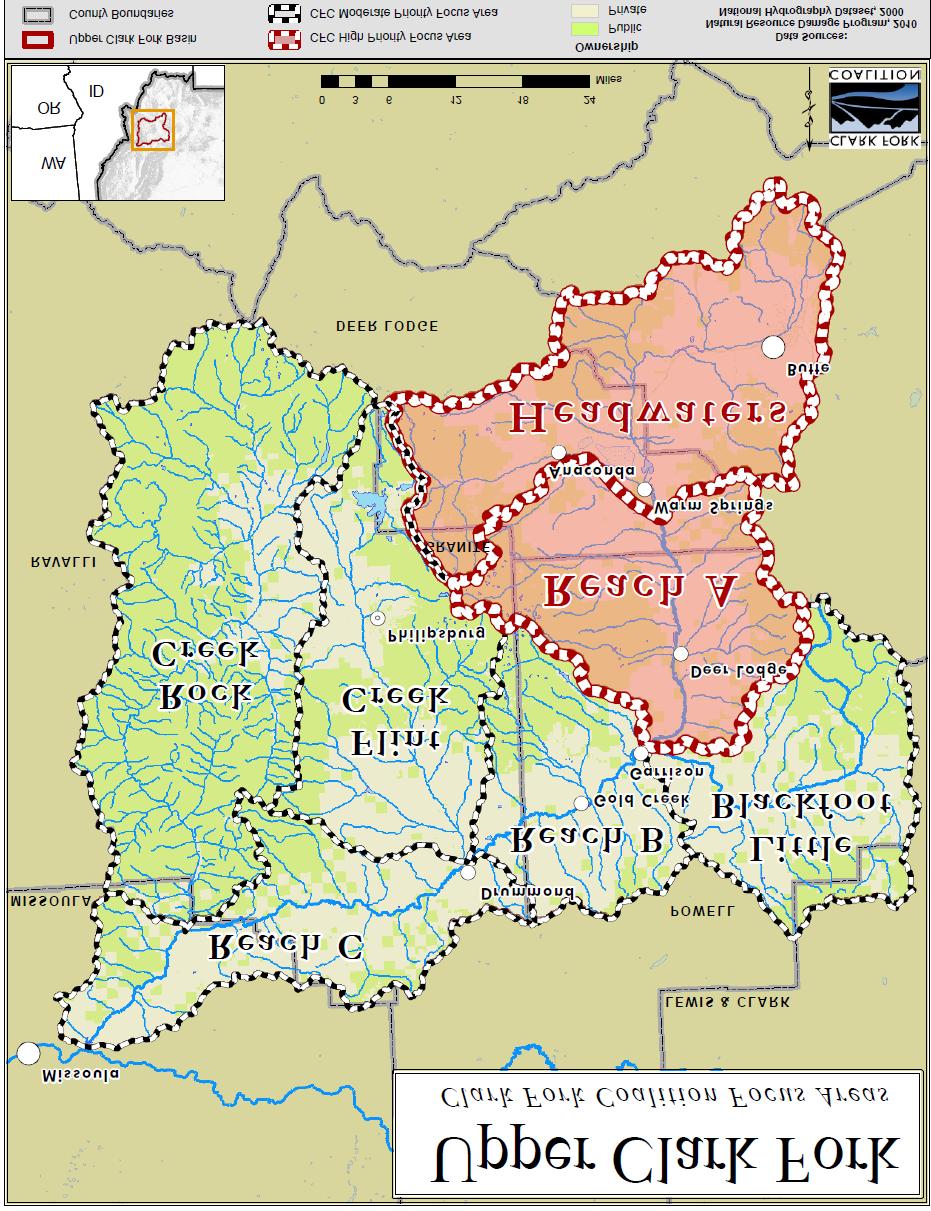
5 1 INTRODUCTION agriculture, forestry and improved recreation. We plan to meet this challenge by creating a model of integrated restoration that delivers a healthy river system and reflects a shared community vision, leveraging the Superfund cleanup into long-term ecological, economic, and cultural benefits for the watershed. The CFC will implement this model of integrated restoration by focusing restoration resources in the Reach A (Warm Springs to Garrison) and the Headwaters sub-basins of the Upper Clark Fork. (See map on p. 8) The most gains for a healthy watershed result from starting upstream and working down. In addition, these two sub-basins are also the most heavily impacted of all seven sub-basins in the Upper Clark Fork, resulting from over 150 years of mining waste compounded with agricultural, urban and land-use impacts. The CFC also has two unique tools for furthering our goal in Reach A and the Headwaters. First, we can provide a riverside ranchlands learning site Dry Cottonwood Creek Ranch, purchased in 2005 by the CFC and two conservation partners and managed by the CFC to explore the challenges that cleanup and restoration bring to the valley s ranchers and the agricultural economy. Secondly, we have the capacity and expertise to pursue flow restoration projects. Water transactions, such as irrigation efficiency and water leasing projects add critical cold water to vital streams and the river in a manner that respects and enhances local agricultural operations. To assure restoration success, the CFC and our partners will link together restoration actions over the entire riverine landscape not just in the contaminated sites but throughout the watershed. Our vision of integrated restoration links tributary stream restoration with mainstem remediation and restoration. It also links the concerns of urban and recreational stakeholders with those of rural and agricultural landowners, and links a science-driven ecological restoration of the basin s natural assets with a vision of economic revitalization in the upper basin. 3

6 1.1 INTRODUCTION PURPOSE AND SCOPE OF DOCUMENT The purpose of this document is to describe the CFC s integrated aquatic ecosystem restoration approach for the Upper Clark Fork. Flow restoration, fish passageconnectivity, habitat enhancement and forest-watershed management projects will be combined strategically across the riverine landscape to achieve successful restoration of the damaged aquatic ecosystem in the Upper Clark Fork. While our primary focus is on aquatic restoration, our strategies also include strengthening sustainable agriculture and improving forest lands, as land management practices are directly tied to watershed health in the Upper Clark Fork. MAP 1 Multiple public and private organizations are actively involved in restoration activities in the Upper Clark Fork. Our main partners include the local Watershed Restoration Coalition (WRC), Trout Unlimited (TU), as well as the state and federal agencies working in this watershed. Effective coordination between these organizations is vital for maximizing and leveraging available resources. This document focuses on the CFC s priorities and strategic approach: where we will work, what we hope to accomplish, and how we plan to get it done. 4
7 1.2 INTRODUCTION CHALLENGE AND A VISION OF DESIRED FUTURE CONDITIONS The Upper Clark Fork is a river on the rebound from over 150 years of hard work as a producer of precious metals. Today, the citizens and landowners of Montana, together with their local governments, state agencies, the Environmental Protection Agency (EPA), U.S. Forest Service (USFS), and others, are pulling together to restore the ecological integrity of the basin, and rebuilding its economic future. The CFC believes that standards for desired future ecological and economic conditions in the Upper Clark Fork basin should be set high. The resources and commitment are all in place to carry out world-class restoration of this river basin. Tremendous progress has already been made cleaning up Silver Bow Creek and removing Milltown Dam and the mining wastes piled behind it now is the time to build on these ongoing book-end projects at the top and bottom of the Upper Clark Fork watershed. These investments will have far-reaching ecological and economic consequences. We have broken the geography of the Upper Clark Fork into 7 sub-watersheds for purposes of prioritizing restoration work in this large landscape (see Map 2 below): the Headwaters, including Silver Bow, Mill-Willow, and Warm Springs Creeks; Reach A, Reach B, and Reach C of the mainstem river; Flint Creek, Rock Creek, and the Little Blackfoot River. During the next decade, we will concentrate our resources and direct investment on Reach A and in the Headwaters to realize the most dramatic benefit for the aquatic habitat. We do recognize that fully achieving the desired future conditions throughout the entire Upper Clark Fork will take longer: possibly years. Below are ecological and economic benchmarks we believe are achievable in that time frame, if restoration investments are well-targeted: Re-establish baseline fishery conditions in the Clark Fork River to ensure salmonid fish density is similar to reference streams such as the Big Blackfoot or Bitterroot; it includes the full diversity of salmonids, suckers, sculpins and minnows found in those nearby rivers; and species reproduce successfully throughout ecologically appropriate parts of the basin. Re-establish westslope cutthroat trout in a majority (over 50%) of the river system: westslope cutthroats are now found in less than 30% of the Upper Clark Fork stream miles, mostly in upper watershed refuges. Re-establish fluvial runs of westslope cutthroat into a dozen reconnected tributaries of the mainstem river, including at least four streams in Reach A, two in Reach B, and six in Reach C. 5
8 1.2 INTRODUCTION Increase bull trout numbers in the upper watershed strongholds; establish a self-reproducing migratory bull trout population in Reaches A, B, and C; and connect the disjunct relic populations in Warm Springs, Flint-Boulder, Harvey and Rock Creeks. Enhance other migratory native fish populations, such as whitefish and suckers, throughout the river system, including abundant spawning in Reaches A, B, and C. Attain healthy populations of top aquatic predators (river otter, bald eagle, osprey, great blue heron) throughout the mainstem and major tributaries. Increase density and diversity of riparian-dependent wildlife (e.g. neotropical birds) in the mainstem and major tributaries of Reaches A, B, and C to reference levels. Allow no invasive mussels, snails, or aquatic weeds to establish in the Upper Clark Fork. Meet all water quality standards, Total Maximum Daily Load (TMDL) targets and INFISH requirements for water temperature, nutrients, sediment and habitat in at least 50% of tributaries. Improve the riparian health in all fish-priority tributaries, so that 50% of reaches are sustainable, and less than 10% of reaches are unsustainable in NRCS assessments. Strengthen the recreational fishing outfitter industry, which is now returning to the Upper Clark Fork and its largest tributaries (Flint Creek, Little Blackfoot, Warm Springs Creek, etc.) Coordinate drought management plans for Reaches A, B, and Flint Creek, to relieve stress on aquatic organisms in dry years, while maintaining key agricultural production. Dramatically increase the acreage under conservation practices on private property. Sustain a thriving agricultural economy, maintaining the approximate current levels of irrigated agriculture and production in Granite, south Powell, and Deer Lodge counties. Diversify agricultural, timber and non-agricultural production and reduce unemployment in the Upper Clark Fork, particularly in small towns: Philipsburg, Drummond, Deer Lodge, and Anaconda. 6

9 1.2 INTRODUCTION These elements of a future vision are linked closely together. A vital fishery requires clean water and restored flows and habitat. It will help provide economic opportunities through outfitting and tourism. Water quality improvements will benefit cold-water fisheries, agriculture, municipalities and overall aesthetic conditions essential to sustainable economies. Improved riparian wildlife habitats and corridors will improve quality of life, especially hunting and wildlife observation. Agricultural operations will benefit from stronger links to local urban markets, better water resource infrastructure, and from the payment for the environmental services (better soil, habitat, and clean water) that appropriate agricultural land uses can provide. In our vision, the Upper Clark Fork fishery and wildlife will be world-class, the ranchlands and agricultural fields will be sustainably productive, a strong agricultural tradition will be handed to future generations, the local economy will be diversified with thriving tourism, forestry, services and manufacturing, and the community will be enriched by young people who want to raise their families to enjoy the exceptional natural, recreational and cultural assets of this place. 7
10 1.3 INTRODUCTION MAP 2 8
11 1.3 INTRODUCTION REGIONAL IMPORTANCE OF RESTORATION IN THE UPPER CLARK FORK The Upper Clark Fork basin is a linchpin in the Northern Rockies landscape for conserving and enhancing fish and wildlife resources. Investing in landscape-scale restoration is ecologically important here because: 1. The Upper Clark Fork is key to overall aquatic restoration success in the Clark Fork basin because successful floodplain cleanup and associated flow and habitat improvements in the headwaters of the basin will provide cleaner water and new fish migration corridors to benefit the entire Clark Fork river system, all the way downstream to Lake Pend Oreille. 2. The Upper Clark Fork includes two of the 12 bull trout recovery areas in western Montana. Restoring bull trout in these two areas, especially connecting the Warm Springs Creek population with the relatively strong Rock Creek metapopulation, is key to providing genetic linkage for overall bull trout recovery, a central recovery goal. 3. The Upper Clark Fork basin sits squarely between the Crown of the Continent, Selway-Bitterroot and Yellowstone ecosystems, the three largest wilderness complexes in the Northern Rockies, and as such provides vital corridors to maintain the ecological connectivity for wildlife. The Upper Clark Fork has been specifically identified as a key linkage between the Crown of the Continent and the Greater Yellowstone (Cushman et.al., 2009; Haroldson, et.al., 2010). The ecological restoration of the Upper Clark Fork is vital for securing the future of the iconic fish and wildlife of the Northern Rockies. 4. Ecological restoration is both an economic driver and a prerequisite to long-term economic recovery in the Upper Clark Fork. Restoration investments will pay off in improved practices for agriculture, forestry, and tourism, increased local income, and a better overall quality of life for rural towns. In summary, this landscape-scale restoration work will help counter the broader threats of species extinction, climate change, urbanization and over-allocation of water resources, and help achieve sustainable resource conservation in the Clark Fork and throughout the Northern Rockies, while sustaining agriculture and strengthening the economy of the basin s towns and communities. 9
12 1.4 INTRODUCTION SETTING The Upper Clark Fork River basin is a 3,710 square-mile watershed flowing from the headwaters near Butte and tributaries in the Anaconda-Pintler, Flint Creek, Sapphire and Garnet mountain ranges, 120 river miles down to the confluence of the Blackfoot River just above Missoula. The headwaters of the Upper Clark Fork include designated wilderness areas such as the Anaconda-Pintler, large roadless areas in the Sapphire Mountains-Rock Creek area, and significant blocks of rugged uplands in all the other ranges. Large ranches dominate the valleys and population density is low: the towns of Philipsburg, Drummond, Deer Lodge, Anaconda, and the city of Butte holding a majority of the population. The Upper Clark Fork basin has a 150-year history of intensive mining, forestry and agriculture. Aquatic and riparian resources of the upper basin were severely injured by the discharge of mining, milling and smelting wastes into the river s headwater streams at Butte and Anaconda, especially from the late 1800s through Tailings and other wastes moved downstream from Silver Bow and Warm Springs Creeks to the river, contaminating the river and severely damaging fish, wildlife, and floodplain soils and vegetation. High levels of arsenic, cadmium, copper, lead and zinc remain in riverbank and floodplain soils, stream sediments, and in aquatic life, especially in Silver Bow Creek and the 43-mile reach of the river from Warm Springs to Garrison, known as Reach A. As a result of this contamination, the Environmental Protection Agency (EPA) designated 22 miles of Silver Bow Creek and 120 miles of the Clark Fork River from Warm Springs to Milltown as two of multiple Superfund sites in the Upper Clark Fork River Basin. Subsequently, the EPA and State of Montana have secured a series of settlements with Atlantic Richfield Company (ARCO) to remediate and restore these mining-related damages. In 1999, ARCO agreed to pay $80 million plus interest to protect human and environmental health along Silver Bow Creek by remediating the pollution. Separately, in 2008, ARCO agreed to pay the State of Montana $96.5 million for cleanup of the Clark Fork River and floodplain, primarily in Reach A. In addition to funds for remediation, the State of Montana and ARCO signed settlement agreements in 1999, 2005, and 2008 with Montana s Natural Resource Damage Program (NRDP) to restore or replace lost or damaged aquatic, terrestrial and groundwater resources in the Upper Clark Fork basin. Some of these funds are targeted for restoration work that will dovetail with Superfund cleanup. For example, $27.5 million is allocated for restoration of the mainstem of the Clark Fork River in Reach A (the State NRDP s 2007 Revised Restoration Plan describes generally how this money will be spent). In addition, the NRDP administers another settlement fund 10

13 1.4 INTRODUCTION of approximately $100 million, which is currently funding restoration along Silver Bow Creek as well as a grants program dedicated to restoration and replacement projects throughout the basin. Although these funds provide important resources for the Upper Clark Fork, the agency lacks an integrated basin-wide ecological restoration plan for spending them. Although the mining history of the basin is critical to an understanding of our current restoration challenges and opportunities, other economic forces are more significant influences on land use and water resources in the basin today. Agriculture and forestry are the dominant land uses in the Upper Clark Fork, and these activities also have impacts on the aquatic ecology of the basin. Integrated ecological restoration in the Upper Clark Fork will require close coordination with agricultural and forestry interests, as well as municipalities, industry, and the USFS, which manages the nearly 50% of the watershed within the Beaverhead-Deerlodge and Lolo National Forests. These national forest lands include a majority of the forested headwater stream systems and provide critical refuges for native fish. Meanwhile, the majority of the land holdings and water rights in the valleys are controlled by agricultural producers, especially beef cattle producers, assuring that these stakeholders in particular will be key partners in any successful restoration of aquatic and riparian health in the Upper Clark Fork. 11
14 1.5 INTRODUCTION OVERVIEW OF ISSUES The Upper Clark Fork is facing a complex set of ecological restoration challenges. The CFC approached its restoration planning with the idea that we need to start with a clear understanding of the issues, so that we can integrate effective responses tailored to each sub-basin, and also at a basin-wide scale. The following are some of the principal restoration issues we are seeing in the Upper Clark Fork: A. HEAVY METALS CONTAMINATION: Runoff from historic mining, milling and smelting deposited huge quantities of arsenic, cadmium, copper, lead and zinc wastes in the floodplain and channel sediments of Silver Bow Creek, Warm Springs Creek and the Upper Clark Fork. Much of the damage occurred during a massive flood in 1908, but hazardous materials were transported into the river s headwaters from the late 1800s until 1956, when the Warm Springs Ponds were completed as sedimentation and treatment basins on lower Silver Bow Creek. Water quality indicators in Silver Bow Creek, the Upper Clark Fork mainstem and some tributaries continue to reflect the legacy of mining damage elevated levels of arsenic, copper, cadmium, iron, lead, and zinc in the water column, in the bed sediments, and in the tissues of benthic macro-invertebrates. Populations of fish and piscivorial birds and mammals are depressed in comparison to comparable Montana streams. These water quality issues and biological issues tend to be most severe in the Silver Bow Creek watershed and Reach A, and tend to diminish downstream as cleaner tributaries like the Little Blackfoot and Rock Creek provide dilution flows (USGS, 2007). Various tributaries in the Upper Clark Fork outside of the Butte-Silver Bow area have a history of small-scale mining, milling and smelting, with resultant metals or mercury contamination of water quality or stream sediments. Tributary watersheds such as Flint Creek, Dunkleberg Creek, and Cottonwood Creek, have a particularly intense mining history, and associated contamination from metals and/or mercury. Mines on the State of Montana s Abandoned Mine Reclamation Priority List are found throughout the Upper Clark Fork ( deq.mt.gov/abandonedmines/default.mcpx) but are particularly common in the Philipsburg-Maxville area of Flint Creek drainage. Montana Department of Environmental Quality s (DEQ) 303d list includes 16 Upper Clark Fork tributary segments impaired by metals or mercury. B. ECOLOGICAL CONNECTIVITY: The mainstem river and several tributaries and have been severely compromised by a combination of irrigation-related dewatering, elevated water temperatures, impassable irrigation infrastructure and inadequate road drainage structures. This problem limits the ability of fish 12
15 1.5 INTRODUCTION to move seasonally in and out of tributaries and up and down the river. Fish move seasonally to seek refuge from temporal water quality issues, and migrate to and from spawning and rearing areas. Ability to migrate is fundamental to the survival of the sport and native fishes of the Clark Fork (Schmetterling, 2003; Schmetterling, et.al, 2006). C. DEWATERING: This term refers to streams where the flows are reduced to the point where habitat is inadequate for fish. Dewatering degrades the overall quality of the aquatic environment in multiple ways. Dewatering of the mainstem exacerbates key water quality and habitat issues in the Clark Fork by reducing dilution of nutrients, allowing water temperatures to become elevated, and reducing dissolved oxygen concentrations. Montana Dept. of Fish, Wildlife and Parks (FWP) categorizes 42 tributaries as dewatered in the Upper Clark Fork, as well as 87 miles of the mainstem river (MT FWP, 2009). D. WATER TEMPERATURE: Warm water is a major limitation for recovering native fisheries, which depend upon clean, cold, clear water. Elevated stream temperature is caused by dewatering, widening of stream channels, and loss of riparian cover. This issue is especially severe for native salmonids in the valley portions of tributaries and in the Clark Fork mainstem. Non-native trout outcompete native trout in warmer waters the remaining conservation populations of bull trout and westslope cutthroat are in forested upper watersheds with cold-water habitats. Scientists are concerned that climate change could have a particularly damaging impact on bull trout (Rieman, Bruce, et.al. 2009) mainly due to loss of habitat from warming water temperatures. Montana DEQ lists only one Upper Clark Fork tributary as impaired by high water temperatures, although the CFC s assessments show this is certainly an underestimate. E. SEDIMENT AND SILTATION: These problems primarily relate to watershed land management, particularly grazing practices, concentrations of livestock in stream corridors, destabilized stream banks, and forest road density. Sediment and siltation degrade instream habitat on numerous tributaries; the DEQ TMDL recognizes 8 tributaries in Reach A and Reach B with sediment impairments, but several tributaries with serious sediment issues were left off that list (e.g. Browns Gulch, Dry Cottonwood, etc.). Roads contribute substantial sediment to tributaries, especially in the headwaters and upland areas of the watershed. The Beaverhead Deerlodge Forest controls the majority of the basin s uplands, and its aquatic conservation strategy focuses on protecting native fish strongholds through designated riparian habitat conservation areas and fish key watersheds. However, even in these fish key watersheds, road densities are often high, so road improvements are a priority in uplands, in order to reduce sediment-related damage to upland aquatic habitat and fish populations (Rieman et.al., 2000). The CFC is interested in promoting road network improvements in coordination with the USFS, DNRC, non-profit partners and other funders. 13
16 1.5 INTRODUCTION F. NUTRIENT ENRICHMENT: This is a well-known problem associated with noxious algae and benthic ecology alterations in the mainstem Upper Clark Fork. Nutrient pollution originates from municipal wastewater discharge (Butte, Deer Lodge, Anaconda), non-point sources (similar to sediment sources), and natural sources of phosphorus in the Little Blackfoot, Warm Springs Creek/Phosphate, and Gold Creek. Due to the hard work of many partners, the mainstem river s nutrient problems have substantially improved over the last 20 years, as documented by the Tri-state Water Quality Council (TSWQC VNRP, 2009), but Silver Bow Creek is still severely limited by nutrient enrichment. Butte, Deer Lodge, and Philipsburg are all working on nutrient management issues related to their wastewater treatment systems. Montana DEQ s 303d list includes 7 tributaries with nutrient issues related to non-point sources, which is also an underestimate. G. HABITAT DEGRADATION: Both the aquatic and riparian habitat in tributaries and along the mainstem river are severely impaired. Tributaries with alterations of channel morphology, loss of floodplain connectivity, loss of aquatic habitat complexity and degraded riparian wetland vegetation are typical of riparian corridors in heavily grazed, logged, and roaded watersheds in western Montana. H. AQUATIC INVASIVE SPECIES: This is a serious threat to native aquatic and wetland species and to overall ecosystem health throughout Montana, and the Upper Clark Fork is no different. Invasive species of concern include non-native mussels, snails, and aquatic plants. Noxious and invasive terrestrial plants in wetland and riparian areas are also a major ongoing threat which must be managed to maintain healthy plant communities and grazing resources. This issue will only become more urgent as recreation pressures increase in the Upper Clark Fork once the natural resources are cleaned up and restored. I. BULL TROUT AND WESTSLOPE CUTTHROAT TROUT VS. NON NATIVE TROUT: The native bull trout is a federally threatened species. The USFWS recently released a new map of bull trout critical habitat (see Map 3). The USFS Beaverhead Deer Lodge Forest Plan (2007) treats bull trout and westslope cutthroat trout (a Species of Concern in Montana) as sensitive species for planning purposes. Many of the fish key watersheds designated in the Forest Plan are bull trout strongholds, or hold robust conservation populations of westslope cutthroat trout. Both are now found primarily in upper watersheds, particularly on USFS land. Non-native brook trout and rainbow trout hybridize with native species (bull trout and westslope cutthroat trout respectively), and non-native brown and brook trout are serious competitors for native salmonids (McHugh and Budy, 2006; Peterson, Fausch and White, 2004). Although these non-native fish species will probably always be present in the Upper Clark Fork, their competitive advantage over natives is enhanced in degraded watersheds, especially where water temperature, sediment supply, and flows have been altered. Stream connectivity projects need to take these competitive/hybridization issues into account, and public and private partners will need to make decisions about whether to reconnect certain tributaries to areas where non-native fish thrive. 14


17 1.5 Missoula INTRODUCTION Upper Clark Fork Forest Service and USFWS Priority Areas LEWIS & CL A RK Clark Fork River MI SSOULA Harvey Creek Drummond Gold Creek POW ELL RAVALLI Alder Creek Stony Creek West Fork Rock Creek Ross Fork Ranch Creek Hogback Creek Copper Creek Rock Creek Carpp Creek Flint Creek Storm Lake Creek Boulder Creek Philipsburg GRANIT E Warm Springs Creek Anaconda Garrison Deer Lodge Warm Springs Butte DEER LODGE WA OR ID Miles Upper Clark Fork Basin County Boundaries Forest Service Priority Watershed for Fisheries Forest Service Priority Watershed for Restoration US Fish and Wildlife Service Designated Critical Bull Trout Habitat Ownership Data Sources: Data Sources: Public Beaverhead-Deerlodge National Forest Prioritization, 2007 Private USFWS Critical Bull Trout Habitat, 2010 MAP 3. NATIVE FISH CONSERVATION PRIORITIES:USFWS & USFS 15
18 2.1 RESTORATION STRATEGY GEOGRAPHIC STRATEGY The CFC is participating in restoration planning in the Upper Clark Fork at multiple scales: a) basin-wide; b) sub-basins associated with specific river reaches; and c) at the level of each tributary. BASIN SCALE PLANNING: entire Upper Clark Fork 3710 sq. miles SUB BASIN SCALE PLANNING: 7 sub-basins of sq. miles TRIBUTARY SCALE PLANNING: Watersheds <50-60 sq. miles BASIN SCALE PLANNING: Basin-scale planning focuses on assessing and prioritizing broad biological and physical restoration opportunities across the entire 3710-square mile basin,e.g. restoring native fish populations and metapopulations, re-establishing aquatic habitat connectivity over the whole basin, protection of large areas of quality habitats, addressing water quality problems that affect the entire river mainstem. An example of successful basin-scale planning in the Clark Fork is the work done over the last two decades by the Tri-State Water Quality Council to reduce nutrient enrichment and noxious algae (TSWQC, 2009), a program the CFC has supported since its inception. The CFC also works on basin-scale water quality and biological issues with partners such as EPA (metals), DEQ s TMDL program, and FWP (e.g. aquatic invaders). The Upper Clark Fork basin would benefit from a coordinated basin-scale aquatic restoration master plan which addresses all the major issues. Some elements of basin-scale planning are already underway. Basin-scale planning and assessment activities of the USFS, Montana FWP-NRDP, and DEQ s TMDL program are summarized in Appendix 1. The CFC s internal basin-scale restoration planning has focused on selecting priority sub-basins for habitat protection, water quality improvements, and fisheries enhancement. The CFC s plan recognizes seven distinct sub-basins within the Upper Clark Fork (see Map 2). Each sub-basin represents an ecological subunit of the larger Upper Clark Fork basin: 1. HEADWATERS: Silver Bow Creek, Mill Creek, Willow Creek and Warm Springs Creek. 2. REACH A: Warm Springs to Garrison, with all tributaries (above the Little Blackfoot confluence) 16
19 2.1 RESTORATION STRATEGY 3. LITTLE BLACKFOOT: the entire sub-basin 4. REACH B: Garrison to Drummond (above the Flint Creek confluence) 5. FLINT CREEK: the entire sub-basin 6. ROCK CREEK: the entire sub-basin 7. REACH C: Mainstem and all the tributaries from Drummond to Milltown, except Rock Creek. The following section explains why the CFC has selected Headwaters and Reach A as the primary sub-basins for our on-the-ground restoration efforts in the coming decade. SUB BASIN SCALE PLANNING :The CFC has prioritized the Headwaters and Reach A as the most effective sub-basins to first invest restoration resources, and we have initiated assessment, planning, and prioritization processes with our partners within these two sub-basins. The Headwaters and Reach A both hold particular importance to overall basin restoration, because they are the most upstream hydrologic units, and they are the locus of the most significant metals contaminant sources. The Deer Lodge Valley in Reach A is also the area with the highest volume of diverted irrigation water in the Upper Clark Fork, which impacts aquatic connectivity and stream temperature. We plan to use these two sub-basins as the focal point for our restoration project, as we concurrently begin assessment, prioritization, and restoration work in the other 5 sub-basins. HEADWATERS: Silver Bow Creek cleanup and watershed restoration is a fundamental element of overall basin restoration, an important fact that has been recognized in the Montana vs. Arco settlement agreements. The CFC supports full cleanup and restoration of Silver Bow Creek and its major tributaries, particularly Blacktail Creek, Basin Creek, Browns Gulch and German Gulch, some of which have healthy native cutthroat trout fisheries. Recent research by Montana FWP has established that westslope cutthroat are using the lower end of the restored Silver Bow Creek, and moving from Silver Bow Creek in and out of tributaries such as Browns Gulch (Lindstrom, J., 2011). Silver Bow Creek mainstem restoration, ongoing since 1999, has created positive impacts for watershed health. Metals concentrations in Silver Bow Creek have been dramatically reduced in the restored reaches. Ammonia toxicity and eutrophication-noxious algae-oxygen depletion are severe limitations for salmonids downstream of the Butte-Silver Bow wastewater treatment plant, although native suckers have been able to colonize this reach (Naughton, J. and R. Cresswell, 2010). Restoration of healthy salmonid populations in Silver Bow Creek will require that the ammonia toxicity and eutrophication issues are addressed by 17
20 2.1 RESTORATION STRATEGY Butte-Silver Bow wastewater treatment plant. The Silver Bow Creek Watershed Plan (NRDP, 2005) is useful in assessing opportunities for further restoration in Silver Bow Creek and its tributaries, including Mill and Willow Creeks. Browns Gulch, Blacktail Creek, Basin Creek, and the nearby watersheds of Mill Creek and Willow Creek near Opportunity also have high fisheries restoration potential, and deserve significant restoration effort. The Watershed Restoration WRC has completed significant assessment work on Browns Gulch, identifying issues related to seasonal in-stream flow, water temperature, nutrient and sediment loading as well as fish passage (Kirk Engineering, 2006). Fisheries habitat assessment work has also been done recently in Blacktail Creek (Pioneer Technical, 2010), but initial habitat assessment is needed in other streams within the Headwaters sub-basin, including Mill and Willow. Warm Springs Creek at Anaconda is one of the premier fisheries in the entire basin, and this creek and its tributaries are extremely important for native trout conservation both bull trout and westslope cutthroat. The Warm Springs tributaries and the associated lakes in the Barker, Twin Lakes, Storm Lake, and Foster drainages are a key source area for future restoration of bull trout into the downstream areas of the Upper Clark Fork. Butte-Silver Bow local government (the owner of substantial industrial water rights in Silver Lake and associated waters) and the U.S. Fish and Wildlife Service are working on a habitat conservation plan for bull trout in the upper Warm Springs Creek watershed, where a number of fish passage and habitat issues need to be addressed. Lower Warm Springs Creek has benefited from instream flow augmentation since the late 1990s, a vital improvement which needs to be secured. REACH A: Integrated ecological restoration in Reach A is another crucial next-step for overall restoration of the entire Upper Clark Fork. Below is a summary of why the CFC is prioritizing this sub-basin for our initial restoration investments: 1. The State of Montana s remediation and restoration funds will remove the toxic metals contamination in the Reach A floodplain from , providing the catalyst for dramatic water quality improvement as it removes a large source of pollution from the watershed. 2. Improving the water quality in this most upstream reach of the river is critical to the entire system, and will have cascading positive effects downstream. 3. To sustain and enhance water quality improvements from the Superfund cleanup in Reach A, it s critical to increase flows of clean, cold water in this reach. In addition, agricultural stakeholders in Reach A have indicated their willingness to work with CFC on flow restoration. 18
21 2.1 RESTORATION STRATEGY 4. Reach A provides potentially excellent fish and wildlife habitat, because the river is unconstrained by railroads and highways, and able to maintain its natural sinuosity, pattern and profile for over 20 miles. This area also has high restoration potential due to: low human population density (outside of the City of Deer Lodge); good condition of the existing riparian and aquatic habitat in the river and in adjacent tributaries; connectivity benefits of high-quality headwaters habitat in tributary corridors linking all the way to the river. 5. There are important conservation populations of westslope cutthroat trout and bull trout in the tributaries of Reach A and the adjacent Headwaters, although the fishery in Reach A is currently dominated by non-native salmonids (brown trout). Once the Superfund cleanup is underway, our restoration efforts can strategically reconnect these strong source populations of native trout to the river and other populations downstream. Section 3 of this report includes the elements of a sub-basin restoration plan for Reach A the Deer Lodge Valley with detailed objectives, recommendations, and ecological milestones in priority tributaries, provided as an example of the restoration planning needed in each sub-basin. We will work with partners to develop similar plans in the Headwaters and other sub-basins. TRIBUTARY SCALE PLANNING GUIDELINES: Tributary-scale planning involves identifying and selecting specific projects to accomplish restoration goals within a given tributary. Assessment work in tributaries will identify the condition, issues, and restoration potential inherent in each reach of the stream. This may take the form of analysis of each fish passage barrier (irrigation structure or road crossing), review of each major water right (for flow restoration potential) and assessment of habitat quality at the individual property or even individual pasture level. The CFC s strategy for tributary level work is based on the following guidelines: 1. Focus on priority tributaries, and address the problems there at a watershed scale. 2. Commit to a long-term investment in priority tributaries. 3. Develop integrated solutions which address multiple objectives in a tributary. 4. Build from ecological strength support the natural process of repopulation from relatively intact, or less-damaged areas in the tributary watershed. 19

22 2.1 RESTORATION STRATEGY 5. Understand the tributary s problems and potential, and develop a good baseline for monitoring change. To maximize the impact of the restoration investments, the CFC will prioritize its projects. We will develop criteria for project prioritizations within each tributary, in conjunction with partner organizations and funders. 20
23 2.2 RESTORATION STRATEGY ECOLOGICAL STRATEGY The ongoing remediation and restoration of Silver Bow Creek and the Clark Fork mainstem will dramatically change those streams potential to support healthy fish populations, including native trout. Research is showing that significant native fish populations can be restored by actions that restore the connectivity between healthy native fish populations in the upper watersheds and the cleaned up and restored habitats in the valley streams. Indeed, monitoring at Silver Bow Creek indicates that effective habitat restoration of even intensely contaminated environments can restore the potential for a variety of native fish to reinhabit these streams (Naughton et.al, 2011). Habitat improvements in tributaries, including riparian and aquatic habitat restoration, will follow on flow and passage restoration, as the biological impacts of restoration and the potential of the mainstem habitats are assessed. Riparian restoration will be a major complement to aquatic restoration and has the additional benefit of improving the wildlife value of these corridors. The following actions summarize CFC s ecological restoration priorities for tributaries in the Upper Clark Fork watershed: 1. Restore flows to reconnect, form and sustain healthy aquatic and riparian habitat. 2. Reconnect tributary streams to the mainstem river and provide fish passage. 3. Enhance aquatic and riparian habitat through better management in all reaches. 4. Improve upland watersheds (roads, forestry) to restore riparian habitat conservation areas, protect native fish habitats, and reduce the input of sediment and nutrients to the aquatic system. FLOW RESTORATION refers to the full-range of ecological flows: re-establishing summer base flows in dewatered reaches, enhancing winter base flows, and improving spring high flows, which are vital to fish migration and to the healthy functioning of channels, floodplains and riparian vegetation. Flow restoration goals are tied to the specific ecological functions that we want to achieve in particular streams. For example, in an intermittent tributary stream, our flow goal 21

24 2.2 RESTORATION STRATEGY may be to improve spring high flows and reconnect the tributary to the river during westslope cutthroat migration in May-June. RECONNECTING HABITATS is critical, especially when high-quality habitats, such as a headwater stream in a National Forest fish key watershed, do not connect to the river. Reconnection establishes the river continuum for all ecological functions, and provides upstream and downstream fish passage. Reconnection often involves flow restoration, replacing road culverts, re-engineering irrigation diversions, installing fish screens, or overcoming water temperature barriers. ENHANCING AQUATIC AND RIPARIAN HABITAT refers to various active and passive restoration activities, including restoring channel stability and integrity, improving riparian vegetation through grazing programs and fencing, or increasing woody debris or other fish habitat features in-stream. Passive restoration through changes in stream-side land use are effective in many cases, but some streams which have had their stream form (pattern, dimension or profile) drastically altered will not return naturally to a stable state, and will remain a sediment source, and/or a poor quality habitat for many decades. In these cases, active reconstruction of sections of a stream may be justified. IMPROVING UPLAND WATERSHEDS is vital for protecting habitat in native fish refugia. One of the key constraints in many tributaries is sediment or nutrient input from forested uplands, due to road density, fires, or other forest management issues. Many of the key techniques we will use in ecological restoration are outlined in the recent WRC-CFC publication Landowners Guide to Fixing Streams on Working Lands in the Upper Clark Fork Watershed (2010). 22

25 2.3 RESTORATION STRATEGY COMMUNITY AND INSTITUTIONAL STRATEGY Establishing good landowner partnerships is central to restoration success. The long-term success of the restoration strategy depends on how the local landowners take care of the river and manage private lands after the Superfund cleanup is over, and tributary restoration projects are installed. When we set out to balance flows between fisheries and agriculture, or improve management of riparian areas, we re talking about capital investment in agricultural practices, and about education. Investment in irrigation, stock water, or fencing technology allows agricultural producers to sustain or even improve their productivity, while lessening impacts on streams. This process also must address the delicate issue of cultural assumptions about the environmental impact of traditional agricultural practices, and the relative value of fish and wildlife. Leaders in the agricultural community, for example in the Conservation Districts, have a vital role to play in supporting a long-term commitment to conservation, and the CFC will seek their advice and collaboration. We will also use local networks including radio, newspapers, and schools to emphasize the compatibility of ecological restoration with agriculture, and to provide support to long-term education on land management that includes an appreciation of aquatic and riparian habitat values. Developing strong partnerships with organizations like the WRC, Montana FWP, Natural Resource Conservation Service, USFS, Conservation Districts, Montana DEQ, and the Natural Resource Damage Program, is as crucial to success as our landowner partnerships. 23

26 3 CLARK FORK COALITION S REACH A INTEGRATED STRATEGY CLARK FORK COALITION S REACH A INTEGRATED STRATEGY After strategic assessment of basin-scale needs and opportunities, and meetings over the past three years with partners, the CFC has identified Reach A as our first priority for restoration work, focusing on the Deer Lodge Valley from Warm Springs to Garrison Junction. We will provide support in the Headwaters sub-basin, where Montana FWP, TU, the WRC, local governments and other partners are taking the lead on restoration work. The CFC s Vital Rivers Program intends to focus much of its effort over the next ten years ( ) towards achieving high-quality ecological restoration of Reach A through systematic work on improving flows, connectivity and fish passage, habitat and watershed management in tributaries to this reach. The planned remediation of metal-contaminated streambanks and floodplain soils in the Clark Fork River Operable Unit must be integrated with systematic restoration of tributary streams in this reach to achieve the best possible ecological results. The mainstem river also is seasonally dewatered, and impaired by high summer water temperatures, high nutrient levels and noxious algae (see mt.gov/query.aspx). We will address these problems with our partners through a combination of basin-scale improvements (e.g. wastewater treatment plant upgrades) and tributary and mainstem projects which provide cumulative water quality benefits to the river itself. At least seven designated westslope cutthroat trout conservation populations exist in Reach A tributaries, particularly on USFS lands. Reconnecting these tributary populations to restored habitats in the valley reaches of tributaries, and on to the mainstem river, is critical to landscape-level restoration success. This will require re-watering the lower reaches of tributaries and reconnecting good-quality tributary habitat to the river, by reconstructing culverts and irrigation infrastructure which form major fish passage barriers. 24

27 3.1 CLARK FORK COALITION S REACH A INTEGRATED STRATEGY GOALS AND OBJECTIVES: WE PROPOSE TO ACCOMPLISH THE FOLLOWING BY 2020: GOAL: Restore a vital and diverse fishery, improved water quality, and healthy riparian corridors to the river and its tributaries in Reach A. OBJECTIVE 1: Meet all ecological flow targets in the mainstem Upper Clark Fork. OBJECTIVE 2: Set and meet ecological flow targets in at least five key tributaries, eliminating dewatered reaches and hydrologically reconnecting these tributaries to the mainstem in Reach A. OBJECTIVE 3: Resolve all physical fish passage barriers in at least five key tributaries to Reach A, permitting upstream and downstream salmonid passage from mainstem to National Forest. OBJECTIVE 4: Meet water quality standards, TMDL targets and INFISH requirements for water temperature, nutrients, sediment and habitat on at least five major tributaries. OBJECTIVE 5: Improve the riparian health in eight tributaries, so that 50% of reaches are sustainable, and less than 10% of reaches are unsustainable according to NRCS assessments. OBJECTIVE 6: Dramatically reduce sediment inputs from USFS roads on eastside tributaries. 25
28 3.2 CLARK FORK COALITION S REACH A INTEGRATED STRATEGY STRATEGIES AND OPPORTUNITIES IN REACH A Partnerships with landowners, WRC, TU, state and federal agencies will be required to achieve these goals and objectives in the Deer Lodge Valley-Reach A. Some of the opportunities that can be seized immediately are listed in the following sections. LARGE AND MEDIUM SCALE FLOW RESTORATION PROJECTS: A limited number of critical senior water rights and diversion sites exist that could significantly benefit flow restoration in the river s Reach A mainstem. The following have been identified and investigated by the CFC: Westside Ditch Canal Lining/Piping: this proposed salvage water project could save cfs diverted from the mainstem river south of Racetrack. This is the most severely dewatered portion of Reach A, and probably the largest potential water savings project on Reach A. Racetrack Lake: purchasing water from this storage reservoir could provide over 650 acre-ft of water (5 cfs for 65 days of flow in Racetrack, or up to 12 cfs for 26 days), most of which is protectable into the Clark Fork River, and would benefit the creek as well as the river. Helen Johnson Ditch Lining/Piping: this is a proposed salvage water project which could provide 4-6 cfs of additional flow to Reach A of the river above Galen Water rights in Warm Springs Creek (Headwaters sub-basin) may also present further opportunities to enhance in-stream flows in Reach A. Silver Lake water owned by Butte-Silver Bow has been released to Warm Springs Creek in recent years, with a significant beneficial impact on flows and nutrient concentrations in the Creek and the upper river this water needs to be secured long-term. TRIBUTARY ISSUES AND OPPORTUNITIES: Assessment is ongoing to determine each tributary s specific issues within Reach A, but a number of opportunities have been identified and are tabulated below for prioritized tributaries. Two tributaries in Reach A (Racetrack and Cottonwood) have been assigned a Tier 1 high priority for aquatic restoration by Montana FWP-NRD (2010), and two others (Dempsey and Lost) have been assigned a Tier 2 priority. The CFC, however, will work on restoration of all eight (8) of the following tributaries, in order to re-establish a larger variety of connected aquatic and riparian habitats in Reach A, and yield a greater cumulative benefit to the water quality and native 26

29 3.2 CLARK FORK COALITION S REACH A INTEGRATED STRATEGY fisheries and wildlife in this reach. It is significant for riparian conservation that four of these Reach A tributary watersheds are partly or wholly within Tier 1 high priority terrestrial conservation areas, and parts of the other four are within a Tier 2 priority terrestrial conservation areas designated by NRD-FWP (NRD-FWP, 2010b). The following eight CFC priority tributaries are listed by geographic location, starting in the upper west side (Lost) and proceeding clockwise around to the upper east side (Perkins). 27
 NRD/FWP Terrestrial Priority (Tier 2) TMDL 303d Listed: Impaired by low-flow, metals (Cu, Pb, Mn, Fe, sulfates, As), nitrogen Issues and Opportunities: Lost Creek is an important brown trout and")
30 3.2 CLARK FORK COALITION S REACH A INTEGRATED STRATEGY Stream: LOST CREEK Watershed size: 61 mi2 Designations: Flow target (FWP, 1986): 16 cfs (year-long) NRD/FWP Fishery Priority Tier 2 (lower Lost Cr.) NRD/FWP Terrestrial Priority (Tier 2) TMDL 303d Listed: Impaired by low-flow, metals (Cu, Pb, Mn, Fe, sulfates, As), nitrogen Issues and Opportunities: Lost Creek is an important brown trout and whitefish spawning stream. A large restoration project was carried out on Lost Creek by FWP in , resulting in substantial improvements to channel form and stability, fish habitat and riparian condition. Dewatering is still an issue in some reaches, and a major fish passage barrier exists at approx. stream mile 6 (Gardner Ditch). Flow projects on Lost Creek may be able to provide additional flow to the Clark Fork. Potential Projects: Number: Flow (cfs): Miles: Flow Projects Fish Passage Projects
 TMDL 303d Listed: Impaired by low-flow, metals (Cu,Cd,Pb, arsenic) Issues and Opportunities: Modesty Creek is disconnected from the Clark Fork it passes directly")
31 3.2 CLARK FORK COALITION S REACH A INTEGRATED STRATEGY Stream: MODESTY CREEK Watershed size: 22 mi2 Designations: Flow target: (none yet established) NRD/FWP Fishery Priority Not assessed NRD/FWP Terrestrial Priority-Tier 2 (in part) TMDL 303d Listed: Impaired by low-flow, metals (Cu,Cd,Pb, arsenic) Issues and Opportunities: Modesty Creek is disconnected from the Clark Fork it passes directly into Westside Ditch in a flume. There is a fish passage barrier just upstream of the I-90 culvert. Nonetheless this lower Creek reach has groundwater inflow, and provides excellent wetland habitat. It should be reconnected to the Clark Fork through construction of a new outlet channel, to provide improved fish and waterfowl habitat. The middle and upper watershed is private land with riparian habitat improvement potential. Middle watershed needs assessment for flow efficiency project potential. Potential Projects: Number: Flow (cfs): Miles: Flow Projects Fish Passage/Reconnection projects Habitat improvement projects miles 29
 NRD/FWP Terrestrial Priority-Tier 2 (in part TMDL 303d Listed: Impaired by low-flow USFS Fish Key Watershed Issues and Opportunities: Racetrack Creek watershed is one of the primary")
32 3.2 CLARK FORK COALITION S REACH A INTEGRATED STRATEGY Stream: RACETRACK CREEK Watershed size: 50 mi2 Designations: Flow targets (MT FWP, 1986): 26 cfs upper, 3 cfs lower NRD/FWP Fishery Priority Tier 1 (lower ) NRD/FWP Terrestrial Priority-Tier 2 (in part TMDL 303d Listed: Impaired by low-flow USFS Fish Key Watershed Issues and Opportunities: Racetrack Creek watershed is one of the primary sources of irrigation water in Reach A. Alpine lakes have been modified to store irrigation water. The lower six miles of Racetrack have dewatering issues in late summer, and would benefit from flow restoration projects. Transition to center pivot sprinklers is widespread and presents opportunities for salvage water, as do several major gravity pipelines that irrigators would like to install to replace ditches/pumps on over 5000 acres. Some potential flow projects, such as acquisition or lease of Racetrack Lake storage water rights, would benefit not only the creek, but also the Clark Fork river. The flow target for lower Racetrack (3 cfs) is unrealistic and needs revision. Riparian and aquatic habitat varies from excellent to poor, and some reaches have been channelized or otherwise degraded. Brown trout spawn in lower Racetrack. The fishery is diverse with high sport fish value, but no pure native trout are present bull trout were found in upper reaches until the 1980s. Potential Projects: Number: Flow (cfs): Miles: Flow Projects Fish Passage/Reconnection Projects 4-13 Habitat projects 4 30
 TMDL 303d Listed: Impaired by low-flow, sediment, nitrate/nitrite Issues and Opportunities: Dempsey Creek has a")
33 3.2 CLARK FORK COALITION S REACH A INTEGRATED STRATEGY Stream: DEMPSEY CREEK Watershed size: 30 mi2 Designations: Flow target (FWP, 1986): 3.5 cfs NRD/FWP Fishery Priority Tier 2 NRD/FWP Terrestrial Priority-Tier 2 (in part) TMDL 303d Listed: Impaired by low-flow, sediment, nitrate/nitrite Issues and Opportunities: Dempsey Creek has a conservation population of westslope cutthroat trout in its upper reaches. It is disconnected from the Clark Fork by severe dewatering most years, especially in the last four stream miles above the river. The riparian corridor in the lower four miles is severely degraded, and several fish passage barriers exist. Opportunities for salvage water through changing from flood irrigation to sprinklers exist, and a gravity pipeline may be possible. Flow restoration projects, fish passage, and riparian habitat improvements are needed in the middle and lower watershed. Potential Projects: Number: Flow (cfs): Miles: Flow Projects Fish passage/reconnection 3-8 Habitat 3 31
34 3.2 CLARK FORK COALITION S REACH A INTEGRATED STRATEGY Stream: COTTONWOOD CREEK Watershed size: 63 mi2 Designations: Flow target (none established yet) NRD/FWP Fishery Priority Tier 2 NRD/FWP Terrestrial Priority-Tier 1 and 2 (in part) USFS: Fish Key Watershed TMDL 303d Listed: None. Low-flow, water temperature, sediment, nutrient impairments. Issues and Opportunities: The fishery includes a significant conservation population of westslope cutthroat trout in the upper watershed, resulting in Fish Key Watershed designation by USFS. Reestablishing fluvial (migratory) cutthroats may be possible a tagged cutthroat ascended the stream for five miles up into the USFS lands in Cottonwood is known for brown trout spawning in the lower watershed. Brook trout competition is an issue for native fish recovery. Cottonwood Creek is disconnected from the Clark Fork by severe dewatering most years, and dewatering issues also occur in winter. Fish passage barriers are a severe issue, with at least five major structures in the lower six miles needing upstream passage improvements and/or screening. Riparian habitat is in fair to good condition, with some channel reaches destabilized or urbanized. The WRC has proposed flow enhancement projects (winter and summer), habitat improvements and several fish passage projects. Road density, culvert passage issues exist in the U.S. Forest Service uplands, and are being addressed by EDLV Stewardship. Emery Mining District has priority mines. Potential Projects: Number Flow (cfs) Miles Flow Projects Fish passage/reconnection (incl. USFS) Habitat (incl. USFS)
 TMDL 303d Listed: Impaired by low-flow, temperature, sediment, N, P, Cu Issues and Opportunities: Peterson Creek is disconnected from the Clark Fork by dewatering most")
35 3.2 CLARK FORK COALITION S REACH A INTEGRATED STRATEGY Stream: PETERSON CREEK Watershed size: 31 mi2 Designations: Flow target (none established yet) NRD/FWP Fishery Priority-none NRD/FWP Terrestrial Priority-Tier 1 and 2 (in part) TMDL 303d Listed: Impaired by low-flow, temperature, sediment, N, P, Cu Issues and Opportunities: Peterson Creek is disconnected from the Clark Fork by dewatering most years. The fishery includes a conservation population of westslope cutthroat trout in the middle and upper watershed, but brook trout are a major competitor for natives. The riparian corridor in the lower seven miles is severely degraded, resulting in temperature, sediment and nutrient loading. Flow restoration projects are needed in the middle and lower watershed. Riparian habitat improvements are needed throughout the lower, and parts of middle and upper watershed. Road and culvert passage issues exist in upper watershed. The lower one mile is partly urbanized/channelized. Potential Projects: Number: Flow (cfs): Miles: Flow Projects Fish passage/reconnection Habitat 5 33

36 3.2 CLARK FORK COALITION S REACH A INTEGRATED STRATEGY Stream: DRY COTTONWOOD CREEK Watershed size: 34 mi2 Designations: Flow target (none established yet) NRD/FWP Fishery Priority none. NRD/FWP Terrestrial Priority Tier 1 TMDL 303d Listed: None. Impaired by low-flow, water temperature, sediment, nutrients. Issues and Opportunities: Dry Cottonwood Creek is a perennial stream with a naturally intermittent reach in the last mile before the Clark Fork river confluence, with flows typically lasting for several months in spring, and drying up in late summer, fall and winter. A conservation population of westslope cutthroat trout exists in the middle and upper watershed. No nonnative salmonids exist, a rare attribute in an Upper Clark Fork tributary. The riparian corridor is degraded in many areas, but a multi-landowner project is currently putting in a riparian grazing/revegetation project. A proposed flow restoration project in the lower watershed could reconnect the Creek to the river and facilitate early season fish migration (native trout have been found near the confluence during spring flows). Several major fish passage issues have been identified in the lower and upper watershed. Road sediment is a severe problem in the middle and upper watershed, some of which should be addressed by USFS EDLV Stewardship Project. Potential Projects: Number: Flow (cfs): Miles: Flow Projects Fish passage/reconnection 4-11 Habitat 4 34
37 3.2 CLARK FORK COALITION S REACH A INTEGRATED STRATEGY Stream: PERKINS/GIRARD GULCH Watershed size: 17 mi2 Designations: Flow target (none established yet) NRD/FWP Fishery Priority none. NRD/FWP Terrestrial Priority Tier 1 (in part) TMDL 303d Listed: None. Impaired by sediment, temperature, nutrients. USFS Restoration Key Watershed. Issues and Opportunities: Perkins Gulch is a perennial stream, but it does not have a permanent outlet to the Clark Fork. There is no irrigation on Perkins or Girard gulches. The fishery includes a small 100% pure conservation population of westslope cutthroat trout in the perennial reaches of Perkins Gulch. Road sediment is a major problem along parts of Perkins, especially the north fork and lower perennial reaches. Riparian condition is degraded by grazing in the lower and middle reaches. The designation as a USFS Restoration Key Watershed (the only one in Pintler Ranger District) should facilitate USFS work on the upper watershed, as should EDLV Stewardship Project. Potential Projects: Number: Flow (cfs): Miles: Flow Projects 0 - Fish passage/reconnection Habitat 3 FUTURE TRIBUTARY ASSESSMENTS NEEDED: Clark Fork tributary watersheds in Reach A which have not yet been assessed include Powell Creek, Tin Cup Joe, and O Neill Creek. O Neill Creek is not used for irrigation, has at least a seasonal connection to the Clark Fork, and may provide good fish spawning potential (a tagged westslope cutthroat ascended ONeill Creek in 2009 fide MT FWP), as well as being Tier 1 Terrestrial wildlife habitat and partly within the new Spotted Dog Wildlife Management Area. Several small streams on the eastside of the Deer Lodge valley were assessed by WRC in 2002, including: Caribou, Orofino, Sand Hollow, and Sand Creeks. None of these streams connect to the Clark Fork, although Orofino Creek apparently has a population of isolated 100% pure westslope cutthroat trout. They are part of a Tier 1 Terrestrial wildlife habitat area. Assessment of all streams with a current or potential connection to the Clark Fork is recommended. 35
38 CLARK FORK COALITION S REACH A INTEGRATED STRATEGY MILESTONES The expected accomplishments for Reach A restoration in the next eight to ten years are summarized below: TABLE 1: SUMMARY OF RESTORATION MILESTONES IN CENTRAL REACH A FOR 2020 STREAM: Flow Restoration (cfs): Fish Passage Barriers Removed: Reconnect to mainstem: Riparian, aquatic habitat restoration (miles): USFS watershed/ road projects: LOST CR. 4 to 8 3 Connected (complete) none MODESTY CR. 2 to 3 1 Yes 6 none RACETRACK CR. 10 to 25 4 Yes 13 none DEMPSEY CR. 3 to 6 3 Yes 8 none COTTONWOOD CR. 2 to 4 10 Yes 15 EDLV stewardship PETERSON CR. 1 to 3 3 Connected 10 EDLV stewardship DRY COTTONWOOD 2 to 4 4 Yes 11 EDLV stewardship PERKINS/ GIRARD 0 0 No natural connection 6 EDLV stewardship OTHER DRAINAGES varies SUBTOTAL: 24 to 53 cfs CLARK FORK MAINSTEM: 20 to 25 2 n/a 43 (DEQ-EPA) none TOTAL: 44 to 88 cfs
39 3.2 CLARK FORK COALITION S REACH A INTEGRATED STRATEGY The ECOLOGICAL AND ECONOMIC OUTCOMES of this work will: Reconnect 5 tributaries (Modesty, Racetrack, Dempsey, Cottonwood, Dry Cottonwood) that currently do not flow to the river in summer back to the Clark Fork mainstem, through flow restoration, fish passage structures, and channel improvements. Provide flow and fish passage improvements to connect 4 conservation populations of westslope cutthroat trout (Cottonwood, Peterson, Dry Cottonwood, Dempsey) back to the Clark Fork river, facilitating potential new fluvial runs of native trout. Improve in-stream flows in the Clark Fork mainstem for 43 miles. Projected improvements in flow during late summer vary from 10% to 40% by reach. Improved flows from tributaries will help address metals, nutrients, and temperature problems in the river. Improve in-stream flow conditions for spring, summer, and fall/ winter on 7 different tributaries, dramatically improving habitat and water quality for fish and other aquatic life. Restore riparian and aquatic habitat in 77 miles of 7+ Reach A tributaries to improve habitat quality and productivity for fish and riparian wildlife. These projects are critical to reconnecting landscape-level habitats by providing migration corridors from the National Forest uplands to the restored floodplain and the Clark Fork mainstem. Reduce entrainment of juvenile fish in large irrigation canals on the Clark Fork mainstem and major tributaries in at least 12 different sites through the installation of fish screens. Improve irrigation efficiency, save energy, and reduce energy and labor costs for dozens of farms and ranches in Reach A who will benefit from infrastructure upgrades to irrigation systems, improved pasture fences and off-stream watering systems. The sustainability of agricultural operations in the Deer Lodge valley will improve. 37


40 M Rock Creek Rock Creek Deer Lodge Tin Cup Joe Creek 2011 Deer Lodge Tin Cup Joe Cr e ek Baggs Creek Bag gs Creek Tin Cup Joe Creek Reese Anderson Creek Cottonwood Creek Reese Anderson Creek Powell Creek Burnt Hollow Creek Powell Creek Boulder Creek Burnt H ollow Creek Boulder Creek Peterson Creek North Fork Dempsey Creek Demps ey Creek Jack Creek Jack Creek North Fork Dempsey Creek Dempsey Cre ek R acetrack Creek Integrated Restoration Strategy for the Upper Clark Fork River CLARK FORK COALITION S REACH A INTEGRATED STRATEGY Clark Fork Peterson Creek Racetrack Creek Racetrack Creek Thornton Creek Orofino Creek Orofino Creek Modesty Creek Modesty Creek Lost Creek Boulder River Dry Cottonwood Creek Boulder River Dry Cottonwood Creek Lost Creek Ante Ante lope Creek lope Creek Warm Springs Creek Perkins Gulch Perkins Gulch 38 Silver Bow Creek Warm Springs Creek Anaconda Browns Gulch Anaconda Perdee Creek Homestead Creek Perdee Creek Opportunity Homestead Creek Opportunity ill Creek Clear Creek Clear Creek Bu ll Run Creek Gregson Creek Bu ll Run Creek Mill Creek i W Gregson C reek Browns Gulch Whitepine Creek Browns Gulch llow Creek Whitepine Creek Butte German Gulch Butte Silver Bow Creek Beefstraight Creek German Gulch Beefstraight Creek Data Sources: Montana FWP Dewatered Stream List, National Hydrography Dataset, USGS Digital Elevation Hillshade, Montana GAP Land Cover Analysis, Watershed Restoration Coalition Fish Barrier Surveys, Legend Clark Fork Basin Riparian Restoration Projects Irrigation Fish Barrier Dewatered Stream Upper Clark Fork Basin Missoula Flow Restoration Projects WA Miles Native Trout Stronghold Butte Area of Interest ID WY OR A SCHEMATIC DIAGRAM OF THE EXPECTED IMPACTS OF THIS WORK IS INCLUDED AS PRE-RESTORATION/POST-RESTORATION DIAGRAM 1.
41 4 RECOMMENDATIONS FOR THE RESTORATION PLANNING PROCESS TABLE 2: PRELIMINARY BUDGET FOR CENTRAL REACH A INTEGRATED RESTORATION STRATEGY: Stream/ Action: Estimated Cost: Clark Fork River/Westside Ditch flow restoration $ 6,000,000-$ 9,000,000 Clark Fork River/ Racetrack Lake flow restoration $ 1,000,000-$ 1,250,000 Clark Fork River/ Helen Johnson Ditch flow restoration Cottonwood Creek/integrated flow,passage, habitat, uplands Peterson Creek/integrated flow, passage, habitat, uplands Dry Cottonwood/integrated flow, passage, habitat, uplands $ 250,000-$ 350,000 $ 1,000,000- $ 1,250,000 $ 300,000- $ 400,000 $ 400,000- $ 600,000 Perkins/integrated habitat, uplands $ 150,000- $ 200,000 Lost Creek/ flow, passage $ 300,000- $ 600,000 Modesty Creek/integrated flow, passage, habitat $ 200,000- $ 300,000 Racetrack Creek/integrated flow, passage, habitat $ 4,000,000- $ 5,000,000 Dempsey Creek/integrated flow, passage, habitat $ 800,000- $ 1,500,000 Other smaller streams $ 500,000 TOTAL: $14,900,000- $20,950,000 39
42 4 RECOMMENDATIONS FOR THE RESTORATION PLANNING PROCESS RECOMMENDATIONS FOR THE RESTORATION PLANNING PROCESS The restoration process has four basic steps: assessment and prioritization, protection of high-quality habitats, restoration of impaired habitats, monitoring and adaptive management. We will address each of these steps at the basin scale (the 3710 mi2 Upper Clark Fork), the sub-basin scale ( mi2 sub-watersheds), and the tributary scale (<65 mi2), as pointed out in Section 2. Although various agencies have addressed some of these steps, there is no coordinated inter-agency effort. To assure successful restoration, the CFC will work to catalyze broad coordination through the following action agenda: ACTION AGENDA: Convene an inter-agency AQUATIC RESTORATION WORKING GROUP for the Upper Clark Fork. Montana FWP, Natural Resource Damage Program, USFS, and non-profits like WRC, TU, and CFC all have staff in the field, and need to facilitate better communication and coordination. Develop a Clark Fork River AQUATIC RESTORATION MASTER PLAN, which organizes, prioritizes and directs funding in a coordinated fashion for maximum ecological benefit over the entire basin. Focus first assessment, planning, and implementation efforts on the Headwaters and Reach A sub-basins and tributaries, and then promote sub-basin-scale assessments proceeding downstream as time and resources allow. Develop a HEADWATERS STRATEGY AND SUB BASIN PLAN for Warm Springs Creek and the tributaries to Silver Bow Creek, with special emphasis on fish passage and tributary restoration. The Silver Bow Creek Watershed Plan provides some guidance on generalized tributary priorities, which need to be developed into more specific tributary plans and projects. 40

43 5 RECOMMENDATIONS FOR THE RESTORATION PLANNING PROCESS Build off the strong foundation of the FWP/NRDP Prioritization of Tributaries in the Upper Clark Fork River Basin for Fishery Enhancement, and SYSTEMATICALLY INVENTORY AND ASSESS THE LIMITING FACTORS IN EACH PRIORITY TRIBUTARY (e.g. irrigation structure/ passage inventories, habitat quality, pollutants) using existing documentation and field surveys. Develop specific FISHERIES GOALS AND BIOLOGICAL OBJECTIVES for each priority tributary. Develop a COMMUNITY INVOLVEMENT STRATEGY with the goal of integrating aquatic habitat improvement and agricultural sustainability. Work with conservation districts, radio, newspapers and schools to emphasize the compatibility of aquatic restoration with agriculture, and to provide support to long-term education on land management that includes aquatic and riparian values. Develop an INTEGRATED FISHERIES AND HABITAT MONITORING PROGRAM FOR TRIBUTARIES, to document the impact of restoration projects and the overall recovery of fish, water quality, and habitat, and to complement the existing monitoring of the mainstem river. Assure that the monitoring program is linked to a FUNDED RESTORATION MAINTENANCE PROGRAM. Longterm support to landowners in maintenance of restoration investments, especially fish passage and irrigation infrastructure, is a key to enduring restoration success. 41
44 5 REFERENCES REFERENCES Bahn, Leslie, 2007, An Assessment of losses to native fish to irrigation diversions on selected tributaries of the Bitterroot River, M.S. Thesis, Montana State University, Bozeman, MT. Beaverhead Deerlodge National Forest, 2007, Land and Resource Management Plan (Forest Plan), Dillon, MT. Cushman, S.A., K.S. McKelvey, and M.K. Schwartz, 2009, Use of empirically derived source-destination models to map Regional conservation corridors, Conservation Biology 23:368:376 Department of Environmental Quality, 2010, Upper Clark Fork River Tributaries Sediment, Metals, and Temperature TMDLs and Framework for Water Quality Restoration, ` Montana DEQ, Helena, MT. Environmental Protection Agency (EPA), 2011, Clark Fork River Operable Unit, Fausch, Kurt, et.al., 2009, Invasion vs. Isolation: Tradeoffs in managing native salmonids with barriers to upstream movement, Conservation Biology, 23(4): Haroldson, M.A., C.C. Schwartz, K.C. Kendall, K.A. Gunther, D.S. Moody, K. Frey, D. Paetkan, 2010, Genetic Analysis of Individual Origins Supports Isolation of Grizzly bears in the Greater Yellowstone Ecosystem, Ursus 21(1): 1-13 Kirk Engineering, 2008, East Deer Lodge Valley Landscape Assessment, Watershed Restoration Coalition, Deer Lodge, MT. Kirk Engineering, 2006, Browns Gulch Watershed Baseline Report, Watershed Restoration Coalition, Deer Lodge, MT. Lee, D.C., Sedell, J.R., Rieman, B.E., Thurow, R.F., Williams, J.E., 1997, Broad-scale assessment of aquatic species and habitats, Chapter 4. Gen. Tech. Rep. PNW-GTR-405. USDA For. Serv., Pacific Northwest Res. Sta., Portland, OR. Lindstrom, Jason, 2011, personal communication, based on fishtagging research in Silver Bow Creek. McHugh, Peter and P. Budy, 2006, Experimental effects of Nonnative Brown Trout on the Individual and Population level Performance of Native Bonneville Cutthroat Trout, Trans. American Fisheries Soc. 135( ). 42
45 5 REFERENCES Montana Dept. of Fish Wildlife and Parks, 1986, Application for Reservations of Water in the Upper Clark Fork River Basin, Helena, MT, November. Montana Department of Natural Resources and Conservation, 2002, Upper Clark Fork River Ditch Efficiency Assessment. DNRC Report WR-3.C.2.UCF. Helena, Montana. Natural Resource Damage Program-Fish Wildlife and Parks, 2010a, Prioritization of Tributaries in In the Upper Clark Fork River Basin for Fishery Enhancement, Montana Fish Wildlife and Parks (Pat Saffel, Brad Liermann, Jason Lindstrom, Ladd Knotek, and Tom Mostad and Carol Fox, NRD, authors), Helena, February draft final report. Natural Resource Damage Program-Fish Wildlife and Parks, 2010b, Upper Clark Fork River Basin Terrestrial Wildlife Resource Prioritization, Montana Fish Wildlife and Parks (Kristi Dubois, Scott Story, Ray Vinkey, and Carol Fox and Greg Mullen, NRD, authors), Helena. August draft final report. Natural Resource Damage Program, 2007, State of Montana s Revised Restoration Plan for the Clark Fork River Aquatic and Riparian Resources, MT Dept. of Justice, Helena, MT, November. Natural Resource Damage Program, 2005, Silver Bow Creek Watershed Restoration Plan; Executive Summary, NRDP, Helena, MT, Dec. Naughton, Joe and Robert E. Gresswell, 2010, Effects of Ammonia and Dissolved Oxygen Concentration on the Distribution and Abundance of Fishes in Silver Bow Creek, American Water Resource Association, Montana Chapter Meeting, Helena, MT, October. Peterson, D.P., K.D. Fausch, and G.C. White, 2004, Population Ecology of an Invasion: effects of brook trout on native cutthroat, Ecological Applications 14(3): Rieman, B.E., Lee, D.C., Thurow, R.F., Hessburg, P.F., Sedell, J.R., Toward an integrated classification of ecosystems:defining opportunities for managing fish and forest health. Environ. Manage. 25, Rieman, B. et.al, 2009, Anticipating Climate Effects on bull trout habitats and populations across the Interior Columbia River Basin, Trans. Amer. Fish Society, 136: Roni, P. et.al., 2002, A Review of stream restoration techniques and 43
46 6 APPENDIX ONE hierarchical strategy for prioritizing restoration in Pacific Northwest watersheds, NA Journal of Fisheries Management, 22:1-20. Saffel, Pat, B. Liermann, J. Lindstrom, L. Knotek, and Tom Mostad, Fox, C., 2010, Prioritization of Tributaries in the Upper Clark Fork River Basin for Fishery Enhancement, Natural Resource Damage Program, Dept. of Justice, Helena, MT. Schmetterling, D., 2003, Reconnecting a fragmented river; movements of westslope cutthroat and bull trout after transport upstream of Milltown Dam, North Amer. Jour. Fisheries Management, 23: Schmetterling, D.,2006, Migrations of Fluvial LargeScale Suckers (Catoostomus macrochilus) after Transport Upstrea of Milltown Dam, MT, NorthWest Science Vol 80, No. 1 Stanford, Jack, JV Ward, WL Liss, CA Frissell, NR Williams, JA Lichatowich, CC Coutant, 1996, A General Protocol for Restoration of Regulated Rivers, Regulated Rivers: Research and Management, Vol. 12: Tri-State Water Quality Council, 2009, Final Report: The Clark Fork River Voluntary Nutrient Reduction Program, , Tri-State Water Quality Council, Sandpoint, ID, August Watershed Restoration Coalition (WRC) and Clark Fork Coalition, 2010, Landowners Guide to Fixing Streams on Working Lands in the Upper Clark Fork Watershed, Missoula, MT. Weins, JA, 2002, Riverine Landscapes: Taking Landscape Ecology into the Water, Freshwater Biology, 47: Williams, Jack, et.al., 2009, Potential Consequences of Climate change to Persistence of Cutthroat Trout Populations, North Amer. Jour. Fisheries Management, 29: Workman, Dennis, J. Kuipers, B. Farling, P. Callahan, 1999, Restoring the Upper Clark Fork: Guidelines for Action, Montana Trout Unlimited, Missoula, MT, April. 44
47 6 APPENDIX ONE APPENDIX ONE: WATERSHED PLANNING EFFORTS IN THE UPPER CLARK FORK A number of recent assessment and planning efforts in the Upper Clark Fork provide an assessment of conditions and issues at a basin scale, and the prioritization of reaches/sub-basins/tributaries. A review of selected recent watershed planning efforts in the Upper Clark Fork follows. A. THE 2007 BEAVERHEAD DEER LODGE FOREST PLAN. The Beaverhead Deer Lodge Forest developed a new Forest Plan in 2007 which includes explicit Aquatic Resources goals, objectives and standards. This Plan specifies a number of Fish Key Watersheds where strong populations of bull trout and westslope cutthroat trout exist. Fish Key watersheds are watersheds where populations of these native fish exhibit numbers, life histories, age classes, recruitment levels, and reproductive characteristics representative of historic conditions (USFS, 2007, p. 12). Length of stream occupied by native trout and the genetic purity of the populations were key criteria in selecting Fish Key Watersheds. Some Fish Key Watersheds were selected in each major sub-basin, while a group of Fish Key Watersheds was selected in upper Rock Creek to provide protection for a larger, migratory native trout population (and bull trout core area). The Forest Service s future management activities for these watersheds emphasizes conservation of westslope cutthroat and bull trout by protecting and restoring components, processes, and landforms that provide quality habitat in concert with the directives of the Inland Fish Conservation Strategy (InFISH). The 2007 Forest Plan also defined restoration watersheds which have a high risk, or known degraded conditions (e.g. related to roads, mines, grazing pressure). These watersheds were prioritized for restoration investments. The USFS Fish Priority Watersheds and Restoration Watersheds for the Pintler Ranger District and Butte Ranger District include the vast majority of the Upper Clark Fork. Those watersheds are shown on MAP: Since many of the most important remaining native trout populations in the Upper Clark Fork are located on USFS lands, this prioritization of watersheds needing protection is extremely important to the overall basin restoration strategy. These Fish Key Watersheds represent strongholds for native fish that require greatest protection, and some of the most important future sources of native fish for repopulation of restored tributaries and mainstem reaches. 45
48 6 APPENDIX ONE B. THE 2010 MONTANA DEQ UPPER CLARK FORK RIVER TRIBUTARIES TMDL. This TMDL document assesses sediment, metals and temperature issues in 31 tributaries to the Upper Clark Fork in Reach A and Reach B (downstream to above the Flint Creek confluence). The focus is on 10 tributaries with documented sediment issues, 11 streams with documented metals contamination issues, and 1 stream with a documented temperature issue. The report quantifies the known sources of contamination in each stream (primarily non-point sources), establishes a total allowable contaminant load, and determines the allocation of that load from each source. This TMDL document does not include tributaries within the Little Blackfoot sub-watershed, the Flint and Rock Creek basins, or other areas in Reach C (below Drummond). But it does give a good basis for understanding water quality improvement needs in tributaries of Reach A and Reach B. In 2010 the Watershed Restoration Coalition initiated further assessment of tributaries under a TMDL implementation grant (see WRC, Sampling and Analysis Plan, 2010). C. THE 2010 MONTANA FISH WILDLIFE AND PARKS/NATURAL RESOURCE DAMAGE PROGRAM Prioritization of Tributaries in the Upper Clark Fork river Basin for Fishery Enhancement. This document provides a logical basis for prioritization of fishery enhancement projects in the entire Upper Clark Fork, based on goals derived from the Natural Resource Damage Program settlements. The fishery goals that guide the prioritization are: 1) restore the mainstem fishery by improving recruitment of trout from tributaries; 2) replace lost trout angling in the mainstem by improving trout populations and fishing opportunities in tributaries; and 3) maintain or improve native fish populations. The FWP/NRD Prioritization of tributaries is not based solely on ecological criteria, but reflects the preferences based on the geographic location of damages on which the settlement agreements were based (i.e., projects in Silver Bow Creek and Reach A, the most upstream reach of the mainstem, receive higher priority). The resulting tributary prioritization map therefore reflects the fishery goals and priorities of the Natural Resource Damage Program, which may vary slightly in geographic emphasis from a prioritization system based simply on ecological criteria. Also, the focus of this document is on tributaries where passive or active restoration is needed and expected to lead to positive ecological results. There is no protection recommendation explicitly integrated into the document for the highest value native fisheries. Nonetheless, the FWP/NRD prioritization process is extremely valuable because it was based on a large fisheries field data collection effort, substantial point-based assessment of aquatic habitat, and sound scientific logic; it is a key guiding document for aquatic restoration planning in the Upper Clark Fork. 46

49 6 APPENDIX ONE DRAFT MAP OF MT FWP/NRDP PRIORITIZED TRIBUTARIES, MARCH,
50 6 APPENDIX ONE D. THE 2007 NATURAL RESOURCE DAMAGE PROGRAM Revised Restoration Plan for the Clark Fork River Aquatic and Riparian Resources. This plan lays out the restoration approach and priorities of the State of Montana for the Clark Fork River corridor, work that will be done in conjunction with the remediation work mandated by the EPA in the Record of Decision for the Clark Fork River. This restoration work will be focused on 1) removing additional tailings in the floodplain, especially Reach A; 2) streambank stabilization and aquatic/terrestrial habitat improvements in Reaches B & C; 3) additional planting in the floodplain; 4) land acquisitions and easements to protect the restored floodplain; and 5) tributary restoration and replacement actions. There is a $27 million (plus interest) budget for restoration. The State has clear restoration goals: 1) restore aquatic resources in the Clark Fork river to baseline conditions; 2) restore terrestrial habitat in riparian zone/ floodplains to baseline conditions; 3) offset the residual effects to flora and fauna from toxics (stream sediment and water quality effects); 4) develop a plan to protect and manage the river corridor; and 5) improve the natural aesthetic values of the Clark Fork. The 2007 Plan document has no detailed strategy to integrate the tributary and mainstem restoration activities, although tributary restoration is a key component of the Plan. Instead, the Plan says These (tributary) restoration efforts will focus on restoring habitat, water quality, and water quantity critical to developing and maintaining a fishery that resembles baseline conditions in the Clark Fork River. restoration may include but is not limited to restoring spawning beds, controlling sediment sources, establishing pool habitat, providing instream and overhead cover, controlling fish passage, and maintaining water quality and quantity. This further tributary work will primarily occur outside of this Restoration Plan, and would be funded through the Restoration Fund grants program. (NRDP, 2007, p.32) E. TROUT UNLIMITED, 1999, RESTORING THE UPPER CLARK FORK: GUIDELINES FOR ACTION. This document provides the outline of a plan to restore water quality and streamflow, riparian habitat, improve aquatic habitat and fisheries, improve recreation, promote public participation, and provide incentives for long-term conservation of lands. Although this document is over a decade old, it lays out an approach to restoring the Upper Clark Fork watershed in an integrated fashion, with specific recommendations for the types of restoration tools that will be most helpful in which reaches and tributaries. Many of the recommendations for restoration priorities and tributary focus areas in Appendix A: Fisheries Restoration, are still relevant. 48

51 6 APPENDIX TWO F. THE 2005 NATURAL RESOURCE DAMAGE PROGRAM SILVER BOW CREEK WATERSHED PLAN. This was an integrated planning effort, including a public involvement process, directed at the 394 sq. mile Silver Bow Creek watershed. This plan identifies and prioritizes specific restoration needs throughout the tributaries to Silver Bow Creek. The plan has not yet been systematically implemented, but its data and priorities are largely still valid. 49
52 APPENDIX TWO: RESTORATION TECHNIQUES 1. FLOW RESTORATION, THE LEGAL BASICS: Water rights in Montana, like in most other western states, are guided by the prior appropriation doctrine or first in time, first in right. The Montana Constitution declares that all waters within the state are owned by the state for the use of its people. Such waters can be appropriated for a state recognized beneficial use. The 1973 Montana Water Use Act, Title 85, chapter 2, MCA, governs post-july 1, 1973 water right appropriations and sets parameters for changing the point of diversion, place of use, purpose of use, or place of storage of any water right. Streamflow restoration requires the change of a consumptive use water right from one state recognized beneficial use (e.g., irrigation, stock, municipal, domestic) through a temporary change or lease of a water right to enhance instream flow to benefit the fishery resource in a designated stream reach. The water right change process is dictated by statute, and , MCA, and administrative rules promulgated by the Montana Department of Natural Resources and Conservation (DNRC), Administrative Rules of Montana , et. seq. A water right holder has 3 options to temporarily change a water right to instream use: (1) lease all or a portion to the FWP; (2) lease all or a portion to a private party who will manage the water right instream to benefit the fishery; or (3) convert the water right to instream use without a lease. The temporary change is limited to 10 years, with unlimited renewals. However, if the water for change to instream use has been made available through the implementation of water savings methods (e.g., ditch lining, piping, switching from flood to sprinkler irrigation), the change period may be extended up to 30 years with unlimited renewals. Both the original change and renewal process are subject to public notice. A typical flow restoration project involves the acquisition or lease of historic irrigation water rights which are then changed to an instream use through the DNRC. Once the change authorization is issued by the DNRC, the water right, which retains its historic priority date, is subject to call from senior water rights and may also call on junior users to relinquish water to fulfill the instream right in times of water shortage. The amount of water available for change to instream flow is generally equal to the amount of water lost to the stream reach designated for instream flow protection under the historic operation of the water right to be changed. Pursuant to (7), MCA, [t]he maximum quantity of water that may by changed to maintain and enhance streamflows to benefit the fishery resource is the amount historically diverted. However, only the amount historically 50
53 consumed, or a smaller amount if specified by the department in the lease authorization, may be used to maintain or enhance streamflows to benefit the fishery resource below the existing point of diversion. The Montana Supreme Court has recently interpreted this statute to allow for the protection of the full historic diverted amount downstream from the historic point of diversion to the historic point of return flows. The DNRC also has the discretion to limit the amount of water available for change to avoid adverse affect to other water right holders. The ability to change consumptive use water rights to instream use has proven to be an effective tool for restoring important fishery flows. In many cases, senior water right holders may divert most, if not all, of a stream to satisfy their water rights. These irrigation diversions lead to dewatering of certain stream reaches, often leaving important tributary streams with dry or nearly dry streambeds and unconnected from mainstem rivers. This tributary connection is important because tributaries often provide spawning and rearing habitat, not only for fish living in the tributary but also for fish that spend most of their lives in the mainstem river. Many species, especially native species that live in a mainstem river annually migrate up the tributaries to spawn, typically in the spring, early summer, or fall, depending on the species. After the fry hatch from the eggs, they may spend many months in the tributary, until they are old enough to move down to the mainstem. When the habitat is dried up, that important connection can be lost migration may not occur, or when it does, the young of the year may not survive the dewatering of the stream. Changing the use of a consumptive water right to instream flow can re-water a reach that has suffered from dewatering, reconnecting a stream to the river. Generally this re-watered stream reach or protected reach begins at or immediately downstream from the historic point of diversion and continues either to the mouth of the stream or to the end of the dewatered reach. FLOW RESTORATION: COMMON TOOLS WATER RIGHT ACQUISITION: The acquisition of water rights for instream flow restoration is typically the most cost-effective solution for enhancing streamflow while offering long-term assurances for permanent flow restoration. The upfront cost of acquiring a water right (valued on a per acre-foot basis) may initially appear expensive when compared to the cost of a temporary lease. However, assuming that the cost of water may increase over time, when projected over a longer term acquisitions make more economic sense. An important consideration in acquiring water rights is the potential of creating an unfavorable social perception, when farm land is dried up or a water right is severed from the land. Another consideration regarding acquisition is currently, under Montana law, only 51
54 DFWP has limited authority to permanently change water rights it holds in fee simple to instream use. Water rights acquired by a private entity, like the Clark Fork Coalition, and converted to instream use are limited to ten year changes (30 year for salvage water) with unlimited renewals, even if those water rights are owned by the private party. WATER RIGHT LEASING: Temporary water leasing has been the most common mechanism for flow restoration in the state. In the short-term, leasing offers a more affordable rate for water per acre-foot cost. However, due to its temporary nature, leasing is likely a temporary fix to de-watering problems. There is generally no guarantee that the leased water right will be available for a lease renewal at the end of each term. In addition, water costs will continue to increase in the future with increased demand. The value of a short-term lease is the ability to experiment with flow enhancement to inform the parameters of a permanent acquisition. Therefore, leasing should be viewed as a more affordable short-term solution to enhancing streamflows, and regarded as a riskier more costly longterm solution to flow restoration. SALVAGE WATER LEASING: Salvage water or conserved water is a portion of a water right which is freed up from the historical duty of water through efficiency improvements. An example is piping or lining an irrigation ditch that conserves ditch seepage water which otherwise would have been lost to the ground during conveyance of irrigation water. Other methods of salvaging water might be when a flood irrigator converts to sprinkler irrigation. This type of irrigation conversion often results in a reduction of diverted volume of water which may be leased to enhance streamflow. Pairing instream flow restoration with irrigation efficiency improvements is essential for flow restoration in the UCFRB where there is great potential to work with large irrigation ditch companies and other water users to conserve or reduce historic diverted volumes of water through infrastructure improvements. FISH PASSAGE IMPROVEMENTS involve reconnecting streams so that fish can move upstream and down at the appropriate season. These projects involve a wide variety of techniques, which include addressing dewatering or stream temperature barriers, as well as physical barriers to fish migration. Road culvert replacements, as well as installing fish ladders and fish screens on irrigation diversions, are some of the most critical needs for improving fish passage in the Upper Clark Fork watershed. Road culverts can create impassable barriers, either through acceleration of stream velocity beyond the limits of certain fish (especially juveniles), or because of drops or artificial waterfalls at culvert outlets. Culvert projects usually involve replacement of culverts, often with a new larger structure, and a new alignment designed to follow the stream s profile and reduce velocities. The most state of 52
55 the art culverts are designed with a stream simulation approach, often using natural stream width and natural substrate in the bottom of the culvert (see Irrigation diversions are a common fish passage barrier on tributaries to the Upper Clark Fork. Irrigation structures which force water to flow over a substantial vertical drop, or which use a shallow hardened splash pad, can impede the upstream migration of fish. Fish ladders are occasionally used to address upstream passage, but a better solution is often to redesign the diversion structures to effectively divert irrigation water, improve the irrigator s control of flow, pass debris during high flows, and allow the natural movement of fish up and downstream, resulting in a win-win situation for irrigators and fish. A second, often more serious, problem at irrigation diversions on tributaries and the mainstem is the entrainment of fish in irrigation canals while they are attempting to move or migrate downstream. This problem can result in high rates of loss of fish through predation or stress, especially when a diversion takes large amounts of water out of the stream high rates of loss of downstream migrating juvenile native fish have been documented in western Montana (Bahn, Leslie, 2007). Fish screens are a solution to this problem. Screens come in a wide variety of styles, including mechanical self-cleaning screens, turbulent fountains, and horizontal, flat-plate or wedge-wire screens, among others. Fish screens can be very expensive. Irrigators who use pivot sprinklers are interested in screens to protect their infrastructure, so a well-designed screen can often serve both agricultural and fishery purposes. HABITAT ENHANCEMENT projects address the loss of habitat integrity and complexity, and aim to improve fish and wildlife diversity and abundance. The diverse set of techniques include both passive and active approaches, and need to be customized to the specific impairments at the site, the type of stream, and the land use. Generally, the passive approach is to simply remove the source of disturbance (for example, changing the frequency and duration of grazing). If streams have been drastically altered, natural processes alone are unlikely to result in improvements within a reasonable timeframe, and the active approach is more suitable (for example, a channelized stream needs to be reconfigured using bio-engineering and heavy earth-moving equipment). UPLAND WATERSHED IMPROVEMENTS typically involve working to reduce the road network, which contribute to sedimentation and fish passage problems. The U.S. Forest Service controls the majority of the basin s uplands, and road density has been demonstrated to be the most important single factor in determining the health of native fisheries on National Forest service lands (Reiman, 2000). Reducing the density of the road network through rolling up, 53

56 decommissioning, or storm-proofing forest roads, especially larger roads near streams, is important for recovering native fish populations. MINE RECLAMATION involves cleaning up abandoned hardrock mines, which can contaminate watershed soils and streams with toxic metals. Some areas of the Upper Clark Fork have numerous old mines, and clean-up of these sites is often expensive. The Coalition is working with the Dept. of Environmental Quality, local governments, and the U.S. Forest Service, and DEQ to tackle these sites and improve water quality. 54
1.Mill Creek Watershed Summary Description and Land Use
 1.Mill Creek Watershed Summary Description and Land Use Table xxx: Mill Creek Watershed Overview Watershed Size 31,435 acres/49.1 sq miles/ 127.1 sq km Elevation Range 5,594 feet [4,967-10,561] Stream
1.Warm Springs Creek (Anaconda) Watershed Description and Land Use
 Watershed Description and Land Use") 1.Warm Springs (Anaconda) Watershed Description and Land Use Table xxx: Warm Springs Watershed Overview Watershed Size 92,288 acres/144.2 sq miles/373.6 sq km Elevation Range 5,781 feet [4,800-10,581]
1.Warm Springs (Anaconda) Watershed Description and Land Use Table xxx: Warm Springs Watershed Overview Watershed Size 92,288 acres/144.2 sq miles/373.6 sq km Elevation Range 5,781 feet [4,800-10,581]
Table xxx: Listed and Suspected Impairments for Willow Creek 2010 Reach Impairment Pollutant Impaired Uses
 1. (Fairmont) Watershed Summary Description and Land Use Table xxx: (Fairmont) Watershed Overview Watershed Size 18,331 acres/28.7 sq miles/74.3 sq km Elevation Range 2,615 feet [4,980-7,595] Stream Miles
Chagrin River TMDL Appendices. Appendix F
 Appendix F The following are excerpts from the Eastern Brook Trout Joint Venture s Conservation Strategy (Working Draft v.6), Conserving the Eastern Brook Trout: Strategies for Action Found at: http://www.easternbrooktrout.org/constrategy.html
Eastern Brook Trout. Roadmap to
 Eastern Brook Trout Roadmap to CONSERVATION Our Brook Trout heritage he wild Brook Trout is an American symbol of persistence, adaptability, and the pristine wilderness that covered North America prior
2017 Bitterroot Strategy. Clark Fork Coalition
 2017 Bitterroot Strategy Clark Fork Coalition Strategy for the Bitterroot Watershed 2017 PURPOSE: The purpose of this document is to explain and update the restoration strategy of the Clark Fork Coalition
CHAPTER 4 DESIRED OUTCOMES: VISION, GOALS, AND OBJECTIVES
 CHAPTER 4 DESIRED OUTCOMES: VISION, GOALS, AND OBJECTIVES Vision One of the first steps in developing this Plan was articulating a vision - a clear statement of what the Plan strives to achieve and what
Black Sturgeon Regional Plan
 Black Sturgeon Regional Plan This is one of twenty Regional Plans that support implementation of the Lake Superior Biodiversity Conservation Strategy (Strategy). The Strategy, prepared and overseen by
Section II: Project Description
 Project Funding 319 Funds Requested $89,700.00 Matching Funds State Cash Match $78,200.00 Local Cash Match $1,800.00 In-Kind Match $1,000.00 Total Match $81,000.00 Other Federal Funds $24,800.00 Total
middle deschutes progress in restoration
 middle deschutes progress in restoration Acknowledgements prepared by: Upper Deschutes Watershed Council Deschutes River Conservancy Oregon Department of Fish and Wildlife DESIGN & PRODUCTION FUNDED by:
Restoring the Kootenai: A Tribal Approach to Restoration of a Large River in Idaho
 Restoring the Kootenai: A Tribal Approach to Restoration of a Large River in Idaho Susan Ireland, Kootenai Tribe of Idaho Future of our Salmon Conference Technical Session August 2016 Healthy Floodplains,
A Comparison of Western Watershed Councils. Presentation Prepared by Jeff Salt, Great Salt Lakekeeper
 A Comparison of Western Watershed Councils Presentation Prepared by Jeff Salt, Great Salt Lakekeeper Presentation Overview Introduction Jordan River Watershed Council Lower Boise Watershed Council Clackamas
Climate Change Adaptation and Stream Restoration. Jack Williams;
 Climate Change Adaptation and Stream Restoration Jack Williams; jwilliams@tu.org 1 Goals for this presentation Develop strategies for adapting streams to climate impacts by Thinking like a watershed Understanding
THE WESTERN NATIVE TROUT INITIATIVE PLAN FOR STRATEGIC ACTIONS November GOALS, OBJECTIVES, and KEY STRATEGIC ACTIONS
 THE WESTERN NATIVE TROUT INITIATIVE PLAN FOR STRATEGIC ACTIONS November 2016 INTRODUCTION In January 2008, after an intensive scoping and development process, the Western Native Trout Initiative (WNTI)
Searsville Dam Removal
 Searsville Dam Removal A unique opportunity for all Presented by the Beyond Searsville Dam Coalition San Francisquito Creek flows into the San Francisco Bay near the Palo Alto Airport and Golf Course seen
OVERVIEW OF MID-COLUMBIA FISHERIES ENHANCEMENT GROUP
 Mid-Columbia Fisheries Enhancement Group MISSION STATEMENT The Mid-Columbia Fisheries Enhancement Group is a non-profit organization dedicated to restoring selfsustaining salmon and steelhead populations
Mid-Columbia Fisheries Enhancement Group Annual Report Fiscal Year 06: July 1, 2005 June 30, 2006
 Mid-Columbia Fisheries Enhancement Group Annual Report Fiscal Year 06: July 1, 2005 June 30, 2006 Mission Statement The mission of the Mid-Columbia Fisheries Enhancement Group is to restore self-sustaining
Funding Habitat Restoration Projects for Salmon Recovery in the Snake River Region SRFB Grant Round Version: 2/19/16
 2016 SRFB Grant Round Version: 2/19/16 Funding Habitat Restoration Projects for Salmon Recovery in the Snake River Region The Project Funding Process Presented by the Snake River Salmon Recovery Lead Entity
Maryland Chapter Trout Unlimited Brook Trout Conservation Effort
 Maryland Chapter Trout Unlimited Brook Trout Conservation Effort Photo by Matt Kline Portfolio of Recent Work MDTU Brook Trout Conservation Coordinator: Scott C. Scarfone, ASLA sscarfone@oasisdesigngroup.com
Statement of Dr. Jack Williams Senior Scientist, Trout Unlimited. Before the
 Statement of Dr. Jack Williams Senior Scientist, Trout Unlimited Before the Subcommittee of Water and Power Energy and Natural Resources Committee United States Senate June 6, 2007 Mr. Chairman, Members
Executive Summary. Map 1. The Santa Clara River watershed with topography.
 Santa Clara River Steelhead Trout: Assessment and Recovery Opportunities December 2005 Prepared By: Matt Stoecker and Elise Kelley, Ph.D. University of California, Santa Barbara Prepared For: The Santa
Little Kern Golden Trout Status:
 Little Kern Golden Trout Status: The Little Kern Golden trout (LKGT) was proposed for federal listing as Threatened under the Endangered Species Act (ESA) on September 1, 1977 by the U. S. Fish and Wildlife
Rehabilitation of Grimes Creek, a Stream Impacted in the Past by Bucket-lined Dredge Gold Mining, Boise River Drainage, July 2008 to August 2011.
 Rehabilitation of Grimes Creek, a Stream Impacted in the Past by Bucket-lined Dredge Gold Mining, Boise River Drainage, July 2008 to August 2011. Pam Harrington TU,1020 W. Main Street Suite 440, Boise,
FISH PASSAGE IMPROVEMENT in California s Watersheds. Assessments & Recommendations by the Fish Passage Forum
 FISH PASSAGE IMPROVEMENT in California s Watersheds Assessments & Recommendations by the Fish Passage Forum FISH PASSAGE IMPROVEMENT in California s Watersheds The mission of the Fish Passage Forum is
REVIEW OF USDA FOREST SERVICE COMMUNITY-BASED WATERSHED RESTORATION PARTNERSHIPS APPENDIX J
 REVIEW OF USDA FOREST SERVICE COMMUNITY-BASED WATERSHED RESTORATION PARTNERSHIPS APPENDIX J Reviews of Watershed Projects Bob Doppelt and Craig Shinn, Portland State University DeWitt John, Bowdoin College
NEVADA DEPARTMENT OF WILDLIFE STATEWIDE FISHERIES MANAGEMENT
 NEVADA DEPARTMENT OF WILDLIFE STATEWIDE FISHERIES MANAGEMENT FEDERAL AID JOB PROGRESS REPORT F-20-50 2014 LAHONTAN CUTTHROAT TROUT STUDY WESTERN REGION NEVADA DEPARTMENT OF WILDLIFE, FISHERIES DIVISION
Burns Paiute Tribe Fisheries Department. Evaluate The Life History Of Native Salmonids Within The Malheur Subbasin Project #
 Burns Paiute Tribe Fisheries Department Evaluate The Life History Of Native Salmonids Within The Malheur Subbasin Project # 199701900 Prior to 1990 Technical and/or scientific background Malheur population,
Conserving the Forests, Lakes and Streams of Northeast Michigan
 4241 Old US 27 South, Suite 2, Gaylord, Michigan 49735 (989) 448-2293 www.huronpines.org info@huronpines.org Prioritized Restoration Projects in the AuSable River Watershed Summer 2015 Update from Huron
Draft Central Valley Salmon and Steelhead Recovery Plan
 Draft Central Valley Salmon and Steelhead Recovery Plan for Sacramento River winter-run Chinook salmon Central Valley spring-run Chinook Salmon Central Valley Steelhead National Marine Fisheries Service
Big Spring Creek Habitat Enhancement and Fishery Management Plans
 Big Spring Creek Habitat Enhancement and Fishery Management Plans November 5, 2012 Big Spring Events and Activities Center Newville, PA Charlie McGarrell Regional Habitat Biologist Pennsylvania Fish and
Salmon Five Point Approach restoring salmon in England
 Salmon Five Point Approach restoring salmon in England Our Mission To restore the abundance, diversity and resilience of salmon stocks throughout England We will do this by:- a) Maximising the production
Trout Unlimited Comments on the Scope of Environmental Impact Statement for the Constitution Pipeline Project, Docket No. PF12-9
 October 9, 2012 Kimberly D. Bose, Secretary Federal Energy Regulatory Commission 888 First Street, NE, Room 1A Washington, DC 20426 RE: Trout Unlimited Comments on the Scope of Environmental Impact Statement
Brook Trout in Massachusetts: A Troubled History, A Hopeful Future
 Brook Trout in Massachusetts: A Troubled History, A Hopeful Future Brook trout are one of the most beautiful and beloved fish in the Eastern United States. In Massachusetts, anglers prize opportunities
Annual Report for Fiscal Year and Future Plans for the Tillamook Bay Watershed Council
 Annual Report for Fiscal Year 2012-2013 and Future Plans for the Tillamook Bay Watershed Council A report prepared for the Tillamook County Board of Commissioners August 2013 Table of Contents: Recently
5B. Management of invasive species in the Cosumnes and Mokelumne River Basins
 5B. Management of invasive species in the Cosumnes and Mokelumne River Basins Cosumnes River The Cosumnes River basin has a number of distinct habitat types that require different management strategies
A BLUEPRINT FOR THE PENOBSCOT RIVER WATERSHED
 A BLUEPRINT FOR THE PENOBSCOT RIVER WATERSHED About this series 2 # for a healthy Penobscot watershed M aine rivers used to be full of fish swimming upstream from the ocean every year on their spawning
WFC 50 California s Wild Vertebrates Jan. 11, Inland Waters (Lakes and Streams) Lisa Thompson
 Lisa Thompson") Inland Waters: Lakes and Streams WFC 50 11 January 2011 Lisa Thompson Fisheries Extension Specialist Wildlife, Fish, & Conservation Biology Department University of California, Davis Take home messages
Inland Waters: Lakes and Streams WFC 50 11 January 2011 Lisa Thompson Fisheries Extension Specialist Wildlife, Fish, & Conservation Biology Department University of California, Davis Take home messages
MCCAW REACH RESTORATION
 Final Report MCCAW REACH FISH RESTORATION PHASE B Jack McCaw Inland Empire Action Coalition http://www.wwccd.net/ Phone: 509-956-3777 Hours: 8:00-4:30 Walla Walla County Conservation District Snake River
PROTECTING LAND & RESTORING RIVERS FOR SALMON & STEELHEAD
 PROTECTING LAND & RESTORING RIVERS FOR SALMON & STEELHEAD Whychus Creek at Camp Polk Meadow Preserve. Photo: Russ McMillan Top photo: Deschutes River Conservancy 1 Photo: Byron Dudley A Unique Collaboration
2012 Bring Back the Natives Awarded Projects
 2012 Bring Back the Natives Awarded Projects EZG # Organization Project Title Project Description Location Description Total Award Amount Grantee Non- Federal Match 31904 Sanctuary Forest, Inc. Mattole
NEVADA DEPARTMENT OF WILDLIFE STATEWIDE FISHERIES MANAGEMENT
 NEVADA DEPARTMENT OF WILDLIFE STATEWIDE FISHERIES MANAGEMENT FEDERAL AID JOB PROGRESS REPORTS F-20-52 2016 REDBAND TROUT EASTERN REGION NEVADA DEPARTMENT OF WILDLIFE, FISHERIES DIVISION ANNUAL JOB PROGRESS
Western native Trout Status report
 Bull trout (Salvelinus confluentus) Data: Draft Recovery Plan, USFWS, 2002; FR Final Critical Habitat Rule - 2005 Partners: ID, MT, OR, WA, NV, FWS, FS, BLM, NPS, Tribes, AK, Canada Species Status review:
Five Counties Salmonid Conservation Program - Fish Passage Design Workshop. February 2013
 Program - Aquatic Organisms and Stream Crossings Ecological Connectivity A watershed is a network of channels that drain a common boundary. Channel characteristics formed by interaction of precipitation,
April 26, Chairman Rockefeller and members of the Fish and Wildlife Committee. Briefing from Mid-Columbia Regional Fish Enhancement Group (RFEG)
") Joan M. Dukes Chair Oregon Bruce A. Measure Montana James A. Yost Idaho W. Bill Booth Idaho Rhonda Whiting Vice-Chair Montana Bill Bradbury Oregon Tom Karier Washington Phil Rockefeller Washington April
Joan M. Dukes Chair Oregon Bruce A. Measure Montana James A. Yost Idaho W. Bill Booth Idaho Rhonda Whiting Vice-Chair Montana Bill Bradbury Oregon Tom Karier Washington Phil Rockefeller Washington April
The Blue Heron Slough Conservation Bank
 1 The Blue Heron Slough Conservation Bank CONSERVATION BANKING July 19-23, 2010 CASE STUDY SERIES The Blue Heron Slough Conservation Bank (Washington) I. OVERVIEW & BACKGROUND: Location: Snohomish River
IZAAK WALTON LEAGUE OF AMERICA. Strategic Plan
 IZAAK WALTON LEAGUE OF AMERICA Strategic Plan 2014-2019 At the turn of the 20th century, uncontrolled discharges of industrial waste and raw sewage, unrestricted logging, and soil erosion threatened to
Kootenai River Habitat Restoration Program. Kootenai Tribe of Idaho - January 27, 2014 Presentation for Kootenai Valley Resource Initiative
 Kootenai River Habitat Restoration Program Kootenai Tribe of Idaho - January 27, 2014 Presentation for Kootenai Valley Resource Initiative Decline of native species Kootenai River White Sturgeon ENDANGERED
Mining & Petroleum Focus Group Southern Rocky Mountain Management Plan. Synopsis of Focus Group Key Issues
 Southern Rocky Mountain Management Plan Page 1 of 6 Synopsis of Focus Group Key Issues Sectors who brought forth issues are listed after the issue in brackets. I. Timeline Completing the plan by June,
FWCP External Projects Delivered by Stakeholders and First Nations
 FWCP External Projects Delivered by Stakeholders and First Nations 2013-2014 For more information contact FWCP-Columbia program manager, Trevor Oussoren Trevor.oussoren@bchydro.com 250-365-4551 2013-2014
Three point plan to addressing land use and habitat loss impacts on Chesapeake Bay tidal fish and shellfish
 Three point plan to addressing land use and habitat loss impacts on Chesapeake Bay tidal fish and shellfish 1. Establish Principles for Protection of Chesapeake Bay Fish and Shellfish The Fisheries GIT
Eastern Brook Trout: Status and Threats
 david anderson Eastern Brook Trout: Status and Threats Background: Brook trout (Salvelinus fontinalis) are the only trout native to much of the eastern United States. They have inhabited the East s coldwater
Amendment to a Biological Assessment/Evaluation completed for the Coon Creek Land Disposal completed December Grand Valley Ranger District
 Amendment to a Biological Assessment/Evaluation completed for the Coon Creek Land Disposal completed December 2007 Grand Valley Ranger District Grand Mesa, Uncompahgre, Gunnison National Forests Prepared
The Calawah River System
 The Calawah River System The Calawah River is the largest tributary of the Bogachiel River and is formed by the confluence of the north and south forks of the Calawah. The two forks of the Calawah, CALAWAH
OKANAGAN RIVER RESTORATION INITIATIVE - FAQ
 OKANAGAN RIVER RESTORATION INITIATIVE - FAQ Initiative background: The health of the q awsitk w (Okanagan River) has been severely impacted by the channelization works that occurred in the mid-1950 s.
Quarterly Progress Meeting - May Brook Trout Outcome. Stephen Faulkner, USGS Brook Trout Action Team Lead
 Quarterly Progress Meeting - May 2017 Brook Trout Outcome Stephen Faulkner, USGS Brook Trout Action Team Lead Through the Chesapeake Bay Watershed Agreement, the Chesapeake Bay Program has committed to
California Steelhead: Management, Monitoring and Recovery Efforts
 California Steelhead: Management, Monitoring and Recovery Efforts Jonathan Nelson Steelhead Restoration & Management Program Oncorhynchus mykiss irideus California Steelhead Distinct Population Segments
ARKANSAS RIVER, LAKE FORK
 ARKANSAS RIVER, LAKE FORK 2012 The station just below County Road 11 (LF1) is routinely sampled as part of the protocol to monitor fish population changes relative to heavy metal cleanup in the Leadville
California Steelhead: Management, Monitoring and Recovery Efforts
 California Steelhead: Management, Monitoring and Recovery Efforts Jonathan Nelson Steelhead Management, Research and Restoration Program Oncorhynchus mykiss irideus California Steelhead - Hot Topics Implementation
3. The qualification raised by the ISRP is addressed in #2 above and in the work area submittal and review by the ISRP as addressed in #1.
 Please find attached a response from The Confederated Tribes of the Warm Springs Reservation of Oregon (CTWSRO) for Project # 2008-301-00, Habitat Restoration Planning, Design and Implementation within
FISHERIES BLUE MOUNTAINS ADAPTATION PARTNERSHIP
 FISHERIES A warming climate, by itself, substantially affects the hydrology of watersheds in the Blue Mountains. Among the key hydrologic changes projected under all scenarios for the 2040s and beyond
Klamath Lake Bull Trout
 Klamath Lake Bull Trout Existing Populations The Klamath Lake Bull Trout SMU is comprised of seven existing populations and four populations classified as extinct or functionally extinct (Table 189). Populations
NEVADA DEPARTMENT OF WILDLIFE STATEWIDE FISHERIES MANAGEMENT FEDERAL AID JOB PROGRESS REPORTS F LAHONTAN CUTTHROAT TROUT EASTERN REGION
 NEVADA DEPARTMENT OF WILDLIFE STATEWIDE FISHERIES MANAGEMENT FEDERAL AID JOB PROGRESS REPORTS F-20-50 2014 LAHONTAN CUTTHROAT TROUT EASTERN REGION NEVADA DEPARTMENT OF WILDLIFE, FISHERIES DIVISION ANNUAL
WFC 10 Wildlife Ecology & Conservation Nov. 29, Restoration Ecology: Rivers & Streams. Lisa Thompson. UC Cooperative Extension
 Restoration Ecology: Rivers and Streams WFC 10 29 Nov 2010 Restoration of ecosystems often involves creating new systems with only partial resemblance to the original ecosystems Lisa Thompson Fisheries
Mountain Columbia Province
 Rolling Provincial Review: Implementation 2001-2003 Province 229 Columbia Basin Fish & Wildlife Authority Province FY 2001-2003 Spending Summaries NPCC Recommendations and BPA Spending by Project Category,
KOOTENAI RIVER BASIN WATERSHED RESTORATION PLAN
 KOOTENAI RIVER BASIN WATERSHED RESTORATION PLAN by Jeff Dunn, Watershed Hydrologist Karen Filipovich, Outreach Consultant Gary Ingman, Water Resources Scientist prepared by RESPEC 3810 Valley Commons Drive,
STEELHEAD SURVEYS IN OMAK CREEK
 STEELHEAD SURVEYS IN OMAK CREEK 2002 Annual Report Prepared by Chris Fisher John Arterburn Colville Confederated Tribes Fish and Wildlife Department P.O. Box 150 Nespelem, WA 99155 Prepared for Project
Benchmark Statement Respecting the Fish, Fish Habitat and Fisheries of Fish and Little Fish Lake, within the Taseko River Watershed.
 Benchmark Statement Respecting the Fish, Fish Habitat and Fisheries of Fish and Little Fish Lake, within the Taseko River Watershed. Information Supporting the Environmental Assessment of the Prosperity
2004 ANNUAL REPORT BOARD OF DIRECTORS
 2004 ANNUAL REPORT Enhancing and protecting the Upper Deschutes River watershed through collaborative projects in watershed stewardship, habitat enhancement, and community awareness. Dear Friends and Supporters,
First Nations Fish Habitat Program Discussion Workbook
 First Nations Fish Habitat Program Discussion Workbook The First Nations Fish Habitat Program is a joint initiative of the Centre for Indigenous Environmental Resources (CIER) and The Southern Chiefs Organization
states and is considered an important asset to conservation and management actions.
 Westslope Cutthroat Trout (Oncorhynchus clarkii lewisi) Data: Status of Westslope Cutthroat trout in the United States: 2002; Partners: ID, MT, WY, FWS, FS, BLM, NPS, Tribes Status of the Westslope Cutthroat
Water in the Deschutes Who needs it?
 Water in the Deschutes Who needs it? Rivers and streams over appropriation and flow alteration. Junior water right holders production agriculture. The Cities long-term supply for growing populations. Climate
Example Applications
 Example Applications The following example applications are intended to present how the tools developed for Trout Unlimited s Brook Trout Conservation Portfolio and Range-wide Assessment of Habitat Condition
Rhode Island Department of Environmental Management Division of Fish and Wildlife American Shad Habitat Plan for the Pawcatuck River
 Rhode Island Department of Environmental Management Division of Fish and Wildlife American Shad Habitat Plan for the Pawcatuck River Prepared by: Phil Edwards, Rhode Island Department of Environmental
EXECUTIVE SUMMARY. Muskegon River Watershed Assessment
 EXECUTIVE SUMMARY This assessment for the Muskegon River watershed is one of a series being prepared by Michigan Department of Natural Resources, Fisheries Division, for river basins in Michigan. This
Management of headwater streams in the White Mountain National Forest
 Management of headwater streams in the White Mountain National Forest White Mountain National Forest Weeks Act of 1911 authorized the federal government to purchase lands east of the Mississippi River
Muskegon River Management Plan
 Muskegon River Management Plan River Management Plan 04, February, 2003 Richard P. O Neal Introduction This Plan is a companion document to the Muskegon River Watershed Assessment (O Neal 1997). The river
Throughout the Pacific Northwest, salmon and steelhead have been listed under the Endangered Species Act because their existence is either threatened
 Throughout the Pacific Northwest, salmon and steelhead have been listed under the Endangered Species Act because their existence is either threatened or endangered. The Upper Willamette River Basin s spring
Abundance of Steelhead and Coho Salmon in the Lagunitas Creek Drainage, Marin County, California
 scanned for KRIS Abundance of Steelhead and Coho Salmon in the Lagunitas Creek Drainage, Marin County, California Prepared for: Marin Municipal Water District 220 Nellen Drive Corte Madera, California
Appendix 23 Baseline Conditions for Bull Trout (Salvelinus confluentus), North and Middle Forks of the Flathead Drainage
, North and Middle Forks of the Flathead Drainage") See also: Appendix 24 Baseline Conditions for Bull Trout, South Fork of the Flathead Appendix 25 Baseline Conditions for Bull Trout, Stillwater Drainage Appendix 23 Baseline Conditions for Bull Trout (Salvelinus
See also: Appendix 24 Baseline Conditions for Bull Trout, South Fork of the Flathead Appendix 25 Baseline Conditions for Bull Trout, Stillwater Drainage Appendix 23 Baseline Conditions for Bull Trout (Salvelinus
What is a River Basin Restoration Priority? 1. Criteria for Selecting a Targeted Local Watershed (TLW) 2. Hiwassee River Basin Overview 3
 2. Hiwassee River Basin Overview 3") Hiwassee River Basin Restoration Priorities 2008 TABLE OF CONTENTS Introduction 1 What is a River Basin Restoration Priority? 1 Criteria for Selecting a Targeted Local Watershed (TLW) 2 Hiwassee River
Hiwassee River Basin Restoration Priorities 2008 TABLE OF CONTENTS Introduction 1 What is a River Basin Restoration Priority? 1 Criteria for Selecting a Targeted Local Watershed (TLW) 2 Hiwassee River
FISHERIES MANAGEMENT PLAN FOR DUFFINS CREEK AND CARRUTHERS CREEK JUNE, 2004
 FISHERIES MANAGEMENT PLAN FOR DUFFINS CREEK AND CARRUTHERS CREEK JUNE, 2004 Toronto and Region Conservation 2004 ISBN0-9732764-0-1 www.trca.on.ca 5 Shoreham Drive, Toronto, Ontario M3N 1S4 phone: 416-661-6600
Implementing the New Fisheries Protection Provisions under the Fisheries Act
 Implementing the New Fisheries Protection Provisions under the Fisheries Act Discussion Paper Fisheries and Oceans Canada April 2013 Contents 1. Introduction 2. Managing Threats to Canada s Fisheries 3.
What was the historic coaster fishery like?
 1 of 6 1/30/2012 12:25 PM Home About Topics Contact Us Fishing Calendar Fish ID Tips FAQs Hack Noyes Research Vessel Is it a unique strain long lost from Wisconsin's shoreline? Fisheries Reports Tributaries
Chadbourne Dam Repair and Fish Barrier
 Chadbourne Dam Repair and Fish Barrier Final Report for the Western Native Trout Initiative Prepared by: Carol Endicott Yellowstone Cutthroat Trout Conservation Biologist Montana Fish, Wildlife & Parks
Know Your River River Afan Salmon and Sea Trout Catchment Summary
 Know Your River River Afan Salmon and Sea Trout Catchment Summary Introduction This report describes the status of the salmon and sea trout populations in the Afan catchments. Bringing together data from
Thursday September 28, 2006
 Center for Riverine Science and Stream Re-naturalization Field Trip Guide Fourth Annual National Conference Assessing Stream Restoration Success: Developing Sustainable Ecological and Physical Systems
Proposed Reclassification of Muskrat Creek, North Platte River Basin in Goshen County, Wyoming
 Proposed Reclassification of Muskrat Creek, North Platte River Basin in Goshen County, Wyoming October 25, 2010 Waterbody: Muskrat Creek - Mainstem of Muskrat Creek from its headwaters downstream to its
Sub-watershed Summaries
 Project Description The Salmon Drift Creek Watershed Council (SDCWC) has focused their efforts in the Salmon River estuary for the past few years. The multifaceted partnership effort is nearing completion
FINAL REPORT. Yonkers Creek Migration Barrier Removal Project Wonderstump Road Del Norte County. Submitted By:
 FINAL REPORT Yonkers Creek Migration Barrier Removal Project Wonderstump Road Del Norte County Submitted By: Del Norte County Community Development Department Yonkers Creek Migration Barrier Removal Project
Minnesota Department of Natural Resources Division of Fish and Wildlife Section of Fisheries. Stream Survey Report. Luxemburg Creek.
 Minnesota F-29-R(P)-24 Area 315 Study 3 March 2016 Minnesota Department of Natural Resources Division of Fish and Wildlife Section of Fisheries Stream Survey Report Luxemburg Creek 2015 Mark Pelham Sauk
Report prepared for: Prepared by: January 2002 BEAK Ref
 AQUATIC ENVIRONMENTAL STUDY KANATA WEST CONCEPT PLAN Report prepared for: ROBINSON CONSULTANTS Prepared by: BEAK INTERNATIONAL INCORPORATED 14 Abacus Road Brampton, Ontario L6T 5B7 January 2002 BEAK Ref.
January 4, Addresses water quality within the Council program.
 Phil Rockefeller Chair Washington Tom Karier Washington Henry Lorenzen Oregon Bill Bradbury Oregon W. Bill Booth Vice Chair Idaho James Yost Idaho Pat Smith Montana Jennifer Anders Montana January 4, 2016
Illinois Lake Management Association Conference March 23, 2018 By Trent Thomas Illinois Department of Natural Resources Division of Fisheries
 Illinois Lake Management Association Conference March 23, 2018 By Trent Thomas Illinois Department of Natural Resources Division of Fisheries Sources of Habitat Impairment Sedimentation Channelization
Southern Oregon Coastal Cutthroat Trout
 Species Management Unit Description Southern Oregon Coastal Cutthroat Trout The Southern Oregon Coastal Cutthroat Trout SMU includes all populations of cutthroat trout inhabiting ocean tributary streams
Outstanding Iowa Waters, Trout Streams & Value to Northeast Iowa
 Outstanding Iowa Waters, Trout Streams & Value to Northeast Iowa Mike Steuck NE District Fisheries Supervisor Karst, WQ & Livestock: Finding a Balance for a Sensitive Geography May 30, 2017 Healthy Rivers,
2009 CONSERVATION PARTNERS GENERAL OPERATING GRANTEES $287,000
 GENERAL OPERATING GRANTEES $287,000 Alliance for the Wild Rockies Helena, MT $3,000 American Prairie Foundation Bozeman, MT $5,000 Alternative Energy Resources Org (AERO) Helena, MT $5,000 America Wildlands
STREAM SURVEY File form No..
 scanned for KRIS THE RESOURCES AGENCY OF CALIFORNIA California Department of Fish and Game STREAM SURVEY File form No.. Date: September 4, 1969. NAME: North Fork Schooner Gulch Creek COUNTY: Mendocino.
P.O. Box 65 Hancock, Michigan USA fax
 This PDF file is a digital version of a chapter in the 2005 GWS Conference Proceedings. Please cite as follows: Harmon, David, ed. 2006. People, Places, and Parks: Proceedings of the 2005 George Wright
At Home on the Elbow River. -Ours to share-
 At Home on the Elbow River -Ours to share- Living in the shed You are part of the Elbow River Watershed. The Elbow River and its tributaries drain over 1,200 km² of land. The source of the Elbow River
Sustaining the Raritan River Watershed
 Sustaining the Raritan River Watershed 8 th Annual Sustainable Raritan River Conference June 10, 2016 Rick Lathrop Department of Ecology, Evolution & Natural Resources Rutgers School of Environmental and