Sub-watershed Summaries
|
|
|
- Agatha Fields
- 5 years ago
- Views:
Transcription
1
2 Project Description The Salmon Drift Creek Watershed Council (SDCWC) has focused their efforts in the Salmon River estuary for the past few years. The multifaceted partnership effort is nearing completion of the first phase of restoration activities and will continue to work with vegetative recovery and monitoring of the salt and freshwater marsh and upland habitats. The Council recognized that there were partnership opportunities and aquatic restoration needs in Schooner Creek that also required their attention. To set the stage for action in the southern portion of their area, the SDCWC submitted a spring 2011 OWEB Limiting Factors Technical Assistance Grant request. This type of effort is a very effective approach to identify and rank restoration opportunities. In September 2011 the council learned that the request could not be funded. Another approach was needed to take advantage of willing partners and aquatic habitat restoration opportunities. The Council approached the OWEB Board with a request for ¼ the cost of a Limiting Factors Analysis for a focused look at the upper Schooner Creek watershed using existing information. The contractor would be asked to assess and report on the feasibility of watershed restoration opportunities in both South Fork and North Fork Schooner Creeks. The Council and contractor chose to use the funds for two OWEB Grant proposals for April 2012 submission by the Council and a summary report identifying future opportunity areas. This report is a summary of Schooner Creek watershed information found in the Drift (Siletz) Watershed Assessment, September 1996, and Oregon Department of Fish and Wildlife stream surveys and spawning ground surveys. Staff from the Hebo District of the US Forest Service provided GIS mapping assistance and completed GIS Intrinsic Habitat Potential and Debris Torrent risk assessments as part of the grant match.
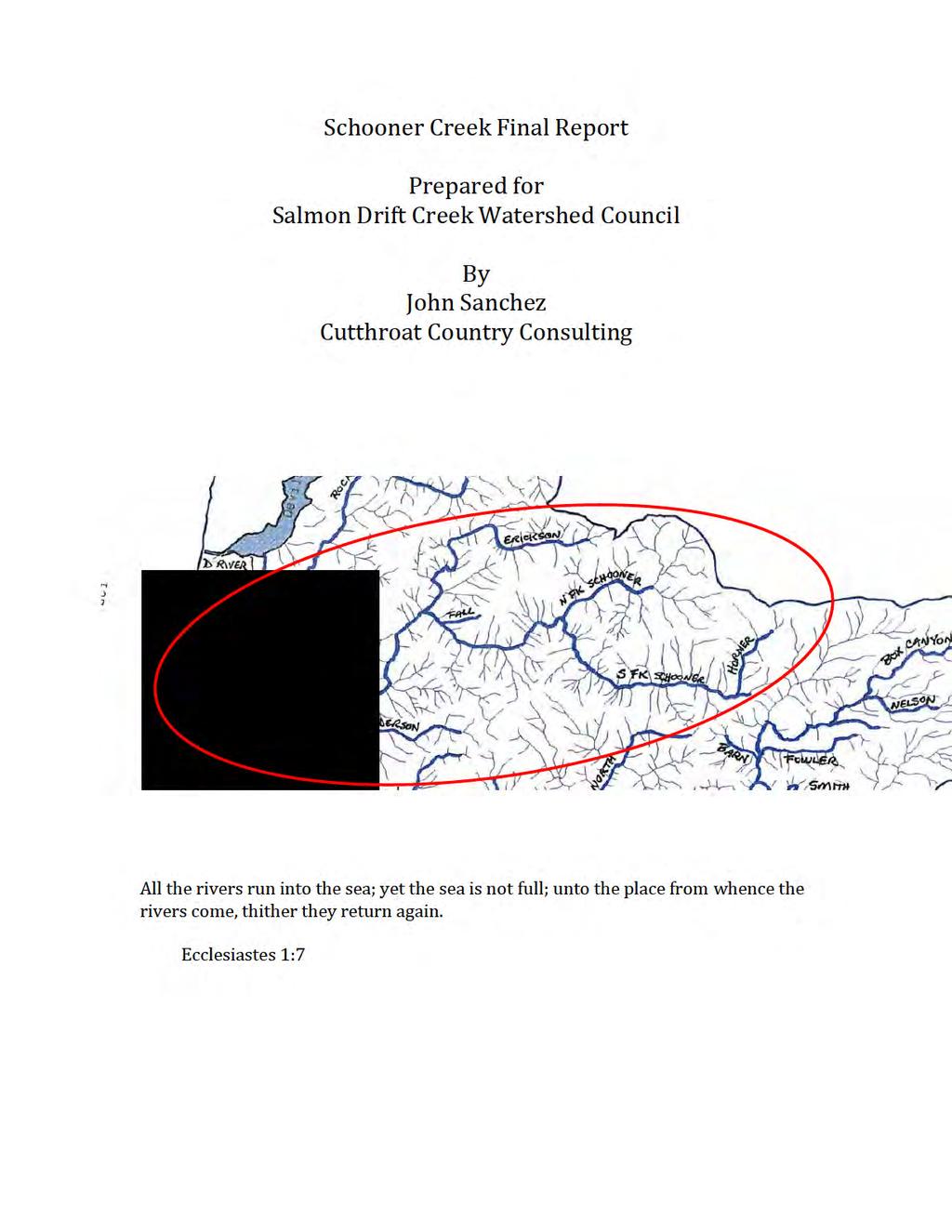
3 Introduction Schooner Creek is a small watershed compared to its neighbors Drift Creek and the Siletz. Its twelve miles of winter steelhead habitat is 4.5% of the total among the three Siletz Bay tributaries. County Road 106 parallels Schooner Creek to the headwaters of North Fork Schooner. The flat portion of the floodplain is private residence and pasturelands. The majority of the watershed is in National Forest yet industrial forestlands occupy many stream adjacent miles of Schooner Creek. It is no surprise to find a creek lacking key large wood and complex pools. The stream adjacent roads are typically a source of fine sediments and other water quality concerns. It is possible for a few restoration projects to make noticeable improvements. An excellent choice for aquatic habitat restoration with ESA listed coho salmon, winter steelhead, sea-run and resident cutthroat trout, and a small population of spawning Fall Chinook salmon. Schooner Creek watershed is found east of Lincoln City on the Central Oregon Coast draining 9,650 acres between Devils Lake tributaries Rock Creek to the north, Salmon River tributary Bear Creek to the northeast, and Drift Creek and its tributaries to the south and east. The Lincoln City community places great value in the watershed resources; water, salmon, and wildlife habitat found in their backyard. The ownership pattern is similar to many other north coast watersheds with private, stream adjacent land low and National Forest and private timber company lands upstream. Private residential land, 2% of the watershed, is predominately Schooner Creek floodplain. Approximately 69% of the land is in Federal ownership, the majority managed by the Siuslaw National Forest. Private timber holdings comprise 29% of the watershed. The National Forest manages for old growth forest characteristics through the Late Successional Reserve (LSR) land allocation. Private timberland is managed on a 40 to 45 year harvest rotation through State Forest Practices Act standards. The highest point in the Schooner Creek watershed is Cougar Mountain at 1782 feet. The waters of Siletz Bay tidally influence the creek mouth.
4 Schooner Creek is a small watershed. Drift Creek drainage is a Forest Service Key watershed. The Siletz drainage has been considered as a wild salmon stronghold. Schooner Creek is a part of the important Siletz Bay drainage role in recovery of ESA Threatened Oregon Coast coho salmon and restoration of Pacific Northwest salmon and their habitats. North Fork Schooner Creek fish ladder was repaired in 2007 improving coho and steelhead access to upstream low gradient habitats that were the site of large wood introduction and monitoring in The Forest Service 1998 Watershed Analysis identified high road density and degraded fish habitat as key issues. They remain key issues. Sediment reduction projects such as road closure/obliteration, road surface and drainage improvement, and road relocations are possible project in both Upper Schooner Creek tributaries to improve aquatic habitats for fish production and water quality. Sub-watershed Summaries South Fork Schooner Creek Overview 2729 acres with 77% Forest Service ownership, 23% industrial forest 3.8 miles of potential fish habitat Road density 5.6 miles/square mile ESA listed coho salmon spawning and rearing above a fish ladder South Fork Schooner Creek Recommendations Oct 2012 OWEB Restoration Grant Proposal coho habitat LWD with Forest Capital Partners Potential restoration grants effectiveness monitoring. Winter juvenile snorkel counts of LWD fish use, redd surveys, and fish ladder counts Assess Road 1781 decommission opportunities for spring 2013 grants Assess opportunities to enhance beaver habitat in headwaters Explore riparian easements opportunities on Private timberlands, stream adjacent and potential debris torrent tracks
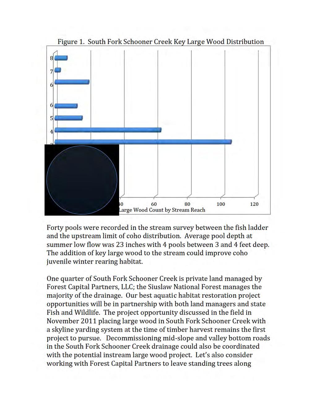
5 Upper Schooner Creek is the emphasis area for this assessment of aquatic habitat restoration. Review of existing watershed analysis, monitoring reports, and surveys points to South Fork Schooner coho salmon winter rearing habitat restoration as high priority. A total of 0.85 miles of coho salmon spawning and rearing habitat is found between the South Fork fish ladder at RM.06 and the current upstream migration barrier at a failed log stringer bridge road crossing. Stream surveyors recorded a total of 21 pieces of large wood in 0.85 miles of coho bearing habitat. Less than 1/3 the amount of wood for proper functioning condition. Three miles of winter steelhead habitat is found above the South Fork fish ladder. The low count of large wood is leads to simplified winter rearing habitat, both main channel and floodplain shallow pools with a lack of complex hiding cover. Derek Wilson, Assistant District Biologist, (personal comm.), assures that the South Fork Schooner Creek fish ladder will be functioning far into the future affording a unique opportunity to monitor adult salmon and steelhead migration into upstream habitat restoration project sites. The Stream Habitat Survey completed August 2011 provides background information for project monitoring. Private land in the lower portion of South Fork Schooner Creek is scheduled for logging within the next two years providing a unique partnership opportunity for instream aquatic habitat restoration. Restoration of coho juvenile winter rearing habitat in the 0.85 miles of accessible habitat above the South Fork Schooner Creek fish ladder is a high priority opportunity. Stream survey data and GIS analysis describes a stream 34 feet to 25 feet wide at a moderate gradient of 2 to 4 percent. Winter stream flows are confined to a relatively narrow stream channel with a flood prone area width is less than twice the active stream channel width. The coho salmon area circled in Figure 1 shows key large wood is less than half the National Marine Fisheries Service (NMFS) standard for proper functioning condition of 80 pieces per mile.
6
7 South Fork Schooner Creek and landslide prone areas within harvest units above the requirements of State Forest Practices Act standards through easement or purchase of wood volume. North Fork Schooner Creek Overview 2139 with 77% Forest Service ownership 2.5 miles of potential fish habitat, 90% on private land Road density 5.7 miles/square mile ESA listed coho salmon spawning and rearing above a fish way North Fork Schooner Creek Recommendations Assess Road/stream fish passage opportunity for spring 2013 grants Recognize Hancock partnership Explore riparian easements opportunities on Private stream adjacent timberlands Outreach headwater residents, habitat restoration The North Fork Schooner Creek Fish ladder was built in 1985 by the Oregon Department of Fish and Wildlife in cooperation with the US Forest Service to provide adult fish passage above bedrock falls to approximately 3 miles of fish habitat, half at less than 2% gradient. The target fish species for upstream passage were coho salmon, winter steelhead and cutthroat trout. The bottom steps of the ladder failed in late 1990 preventing upstream fish passage. In the summer of 2007 a Salmon Drift Creek Watershed Council project in partnership with Oregon Department of Fish and Wildlife, Army Corp of Engineers, US Fish and Wildlife, and US Forest Service, Hebo Ranger District constructed an ODFW roughened channel design project to re-establish year round unimpeded adult fish passage. Past fish habitat restoration efforts include road/stream fish passage improvement at Sword Fern Creek and a 2006 OWEB funded SDCWC key large wood placement project working with ODFW and Green Diamond land managers in partnership to place 33 key logs at 11 sites in one mile of stream. Post project monitoring in the summer of 2007 counted 44 key logs including those placed in Rearing juvenile coho salmon can be observed using habitat created by large wood in
8 these flat (0.8% to 1.4%) project stream reaches. Additional large wood has been proposed in a Spring 2012 OWEB restoration grant application to build on existing large wood habitat and create new log jams on the land now managed by Hancock Forest Management. The Schooner Creek road gravel surface is in good condition but drainage of water from the road surface could be improved to reduce the amount of sediment entering Schooner Creek and North Fork Schooner Creek. Road decommissioning in the North Fork Schooner Creek drainage will also be pursued. Erickson Creek Overview 1857 acres, 87% Forest Service ownership 3.8 miles of potential fish habitat, 90% on USFS land Road density 5.5 miles/square mile ESA listed coho salmon spawning and rearing in lower ½ mile Headwaters stream gradient could support beaver Erickson Creek Recommendations Request a Forest Service Stream Survey Outreach residents at the mouth of Erickson Cr Outreach headwater residents, habitat restoration Assess Road decommission opportunities for spring 2013 grants The lower half-mile of Erickson Creek is in private residential ownership. Coho salmon and winter steelhead are found in this stream reach. The remainder of the sub-watershed is within the Siuslaw National Forest. Elevation mapping using GIS shows unconfined stream reaches at 2% to 4%. Cutthroat trout are present. Lower Schooner Creek Overview Highest coho habitat intrinsic potential in the watershed ESA listed coho salmon spawning and rearing throughout
9 Lower Schooner Creek Recommendations Partner with, Confederated Tribes of the Siletz Indian Reservation on tidal influence LWD placement and lamprey habitat restoration Outreach Rural residence/salmon interface (All stream habitat is in private ownership) Implement proposed OWEB grants with Hancock, County, and USFS Explore riparian easements opportunities on Private stream adjacent timberlands Partner with FCP on tributary streams lands August 1997 ODFW completed a stream survey of Schooner Creek from the power line stream crossing approximately 1 mile upstream from the Highway 101 Bridge to the junction of North and South Fork Schooner Creek. The 6.1-mile survey was divided into 7 reaches with a total of 263 habitat units. Twenty-three key pieces of wood 40 feet in length with a 23.6-inch dbh were counted throughout the survey. The 0.75 stream miles below Anderson Creek Road are at a gradient of 0.3% through predominately pastureland with no key large wood encountered. Consider a riparian easement/enhancement and large wood placement project in the future.
10 Appendix Intrinsic Potential Debris Torrent Risk Oasis Adult Spawning Ground Survey
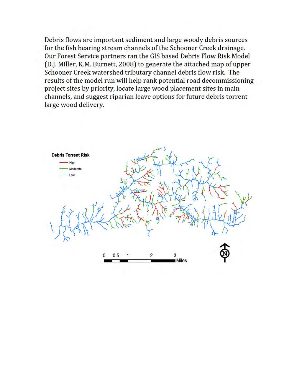
11 Intrinsic Potential The scientists at the Coastal Landscape Analysis Modeling Study (CLAMS) developed a topographically based tool to assess the potential for watersheds to provide high quality fish rearing habitat. The intrinsic potential is determined from channel gradient, valley constraint, and mean annual discharge. Species-specific attributes for rearing habitat value were derived from the literature and observation. The Debris Torrent Risk Model was also developed through CLAMS to help identify watershed features that are most likely to produce a debris torrent with a landslide event. Our partners, Hebo Ranger District Fish Biologist and Hydrologist staff ran the Intrinsic Potential Model and Debris Torrent Risk Model for upper Schooner Creek producing the graphic results below. The Schooner Creek drainage produces a medium size stream with the potential to produce high quality coho and winter steelhead rearing habitat. South Fork Schooner Creek is medium potential intrinsic potential coho rearing habitat and high intrinsic potential winter steelhead rearing habitat. Oregon Department of Fish and Wildlife research found greater concentrations of rearing coho salmon in medium size unconstrained stream channels of low gradient (>2%) with decreasing coho density up to a maximum 8% gradient. Winter steelhead trout rearing densities tended to be greatest in a little higher gradient (2% to 3%) habitat in constrained channels and smaller streams higher in the watersheds. Miller, D.J., Burnett, K.M A probabilistic model of debris-flow delivery to stream channels, demonstrated for the Coast Range of Oregon, USA. Geomorphology 94,
12
13
14 OASIS Adult Spawning Ground Survey Data Oregon Adult Salmonid Inventory and Sampling Project (OASIS) is one of four Oregon Department of Fish and Wildlife Oregon Plan monitoring projects focusing on adults. The other three focus on juvenile salmon, habitat, and survival. The Coastal Salmonid Inventory Project staff out of Corvallis, Oregon was willing to share spawning ground survey data collected October through January for coho, Chinook, and chum and February through May for winter steelhead trout. Random survey data from November 1990 through January 2011 designed to monitor status and trend of naturally produced Oregon coastal salmonids was made available. Surveyors walk upstream counting redds, live and dead fish by species and sample carcasses for gender, length, scales, fin clips and tags. The survey is not designed to monitor the fish population of Schooner Creek for population estimates specific to Schooner Creek. Schooner Creek was randomly selected to help characterize the entire coastal Oregon salmonid population adult trends. The monitoring data is helpful for us to identify fish species spawning distribution and timing. We will not be able to use the data for relative run size. Schooner Creek reach 0.5 below North/South Fork was surveyed in 1990 and 94, 2001, 06,09, 10. North Fork Schooner Creek was surveyed in 1997, 2005 and South Fork Schooner was surveyed in 2002, 2009, and South Fork Schooner Creek mouth to Horner Creek In 1999 spawning ground surveys were conducted every two weeks from February 5 th through April 28 th. No adult steelhead or salmon were observed. Surveyors did comment that juvenile coho were observed. A lack of pools was noted but spawning gravel was considered relatively abundant. The 2002 weekly surveys started on November 1 st and completed on January 21 st. Six coho and one redd were counted with peak spawning estimated December 18 th.
15 In 2009 spawning ground surveys were walked November 4 th through January 28 th. Two adult Chinook were observed November 24 th. A total of 19 redds were counted from December 2 nd to the end of the survey. Peak count was on December 30 th with 2 fish observed. Once again in the surveyors notes we have mention of juvenile coho and spawning gravel throughout the survey reach. South Fork Schooner from Horner Creek to the headwaters of the creek was field checked. No coho spawning habitat was found in this reach. Horner Creek was not surveyed. North Fork Schooner, The one mile spawning ground survey from the mouth of North Fork Schooner Creek to Tributary A was conducted winter 1990, 94, 01, 06, 09, 10. The winters of 1990 and 1994 surveys were completed November 1 to January 31. Few coho or redds were counted. Four redds were counted in mid-november 1990 and one the same time of year Only 2 adults were observed during the reported peak count of adult coho each year in late November. Chinook and winter steelhead were not observed in 1990 or I am not certain of the year the bottom of the North Fork fish way near the mouth of North Fork failed. Spawning ground surveys results show no adult coho or redds were observed in North Fork Schooner Creek from the mouth to Tributary A in 2001 and 2006 or shorter surveys in the same reach in 2005 and The North Fork Schooner Creek fish way was repaired summer 2007 restoring upstream adult anadromous fish passage. Spawning ground surveys results record a dramatic increase in redds and adult coho salmon counts in North Fork Schooner Creek in Redd count in 2009 was a total of 107. A total of One 129 adult coho were counted with a peak adult count of 25 fish observed on January 7, Redds were observed from late November through early January with a total of twenty redds observed in The peak adult coho count on December 17, 2010 was 8 fish. Carcasses were counted in 2009 and 2010 December 9 through January 11.
16 Schooner Creek Erickson Cr to North Fork A 1.25 mile segment of Schooner Creek between Erickson Creek and North Fork was surveyed in 1990 with a peak count of 9 adult Chinook and 4 coho salmon was counted on November 7 th. A total of 38 redds were counted that year in the reach. The spawning ground survey was shortened to approximately 0.5 miles in 2003, 04, and 08. The 2003 peak count of 6 Chinook were observed on October 30 th. The coho peak count of 18 adults was recorded on November 23 rd. In 2004 the peak Chinook count was 9 fish on October 29 th. The coho peak of 7 fish was counted on November 20 th. Fewer fish were observed in this spawning ground survey in No Chinook were counted. Three coho were counted on January 9 th.
3. The qualification raised by the ISRP is addressed in #2 above and in the work area submittal and review by the ISRP as addressed in #1.
 Please find attached a response from The Confederated Tribes of the Warm Springs Reservation of Oregon (CTWSRO) for Project # 2008-301-00, Habitat Restoration Planning, Design and Implementation within
Annual Report for Fiscal Year and Future Plans for the Tillamook Bay Watershed Council
 Annual Report for Fiscal Year 2012-2013 and Future Plans for the Tillamook Bay Watershed Council A report prepared for the Tillamook County Board of Commissioners August 2013 Table of Contents: Recently
MCCAW REACH RESTORATION
 Final Report MCCAW REACH FISH RESTORATION PHASE B Jack McCaw Inland Empire Action Coalition http://www.wwccd.net/ Phone: 509-956-3777 Hours: 8:00-4:30 Walla Walla County Conservation District Snake River
Abundance of Steelhead and Coho Salmon in the Lagunitas Creek Drainage, Marin County, California
 scanned for KRIS Abundance of Steelhead and Coho Salmon in the Lagunitas Creek Drainage, Marin County, California Prepared for: Marin Municipal Water District 220 Nellen Drive Corte Madera, California
OREGON DEPARTMENT OF FISH AND WILDLIFE ROGUE FISH DISTRICT REPORT
 OREGON DEPARTMENT OF FISH AND WILDLIFE ROGUE FISH DISTRICT REPORT TITLE: Upper Rogue Smolt Trapping Project, 1999 STREAM: Big Butte, Little Butte, South Fork Big Butte, Slate and West Fork Evans Creeks
Oregon Coast Coastal Cutthroat Trout
 Oregon Coast Coastal Cutthroat Trout Species Management Unit Description The Oregon Coast Coastal Cutthroat Trout Species Management Unit (SMU) includes all populations of cutthroat trout inhabiting ocean
Fish Habitat Restoration and Monitoring in Southeast Washington. Andy Hill Eco Logical Research, Inc.
 Fish Habitat Restoration and Monitoring in Southeast Washington Andy Hill Eco Logical Research, Inc. Fish Habitat Restoration and Monitoring in Southeast Washington Talk overview: Restoration projects
Blue Creek Chinook Outmigration Monitoring Technical Memorandum
 Blue Creek Chinook Outmigration Monitoring 2012 Technical Memorandum Prepared by: Andrew Antonetti and Erika Partee Yurok Tribe Fisheries Program PO Box 1027 Klamath, California 95548 In Partnership with:
The Calawah River System
 The Calawah River System The Calawah River is the largest tributary of the Bogachiel River and is formed by the confluence of the north and south forks of the Calawah. The two forks of the Calawah, CALAWAH
Southern Oregon Coastal Cutthroat Trout
 Species Management Unit Description Southern Oregon Coastal Cutthroat Trout The Southern Oregon Coastal Cutthroat Trout SMU includes all populations of cutthroat trout inhabiting ocean tributary streams
PRE- PROPOSAL FORM - Lewis River Aquatic Fund
 PRE- PROPOSAL FORM - Lewis River Aquatic Fund 1. Applicant organization. USDA Forest Service Gifford Pinchot National Forest 2. Organization purpose Resource management agency 3. Project manager (name,
ELK RIVER WATERSHED ACTION PLAN
 ELK RIVER WATERSHED ACTION PLAN Prepared for The Elk River Watershed Council Prepared by Chris Massingill Mainstream Contracting South Coast Watershed Council September 2001 South Coast Watershed Council
Mid-Columbia Fisheries Enhancement Group Annual Report Fiscal Year 06: July 1, 2005 June 30, 2006
 Mid-Columbia Fisheries Enhancement Group Annual Report Fiscal Year 06: July 1, 2005 June 30, 2006 Mission Statement The mission of the Mid-Columbia Fisheries Enhancement Group is to restore self-sustaining
STEELHEAD SURVEYS IN OMAK CREEK
 STEELHEAD SURVEYS IN OMAK CREEK 2002 Annual Report Prepared by Chris Fisher John Arterburn Colville Confederated Tribes Fish and Wildlife Department P.O. Box 150 Nespelem, WA 99155 Prepared for Project
Strategies for mitigating ecological effects of hatchery programs
 Strategies for mitigating ecological effects of hatchery programs Some case studies from the Pacific Northwest Kathryn Kostow Oregon Department of Fish and Wildlife Ecological risks occur when the presence
CHAPTER 4 DESIRED OUTCOMES: VISION, GOALS, AND OBJECTIVES
 CHAPTER 4 DESIRED OUTCOMES: VISION, GOALS, AND OBJECTIVES Vision One of the first steps in developing this Plan was articulating a vision - a clear statement of what the Plan strives to achieve and what
California Steelhead: Management, Monitoring and Recovery Efforts
 California Steelhead: Management, Monitoring and Recovery Efforts Jonathan Nelson Steelhead Management, Research and Restoration Program Oncorhynchus mykiss irideus California Steelhead - Hot Topics Implementation
10 is bounded by wetlands between RM 1.8 and 3.1 on the south shore and more are scattered
 The Ozette System The Ozette watershed is made up of several lakes and large streams that combine to a total drainage area of 88.4 square miles. The most significant feature of the Ozette watershed is
California Steelhead: Management, Monitoring and Recovery Efforts
 California Steelhead: Management, Monitoring and Recovery Efforts Jonathan Nelson Steelhead Restoration & Management Program Oncorhynchus mykiss irideus California Steelhead Distinct Population Segments
CHAPTER 2 - THE COQUILLE FISHERY
 CHAPTER 2 - THE COQUILLE FISHERY TABLE OF CONTENTS A. INTRODUCTION... 2-1 FIGURE 2-1 Life Histories of Anadromous Salmonids in the Coquille River... 2-2 1. Coho Salmon... 2-2 FIGURE 2-2 Coho Packed or
South Fork Chehalis Watershed Culvert Assessment
 South Fork Chehalis Watershed Culvert Assessment Water Resource Inventory Area 23 Lewis County Conservation District Final Report By: Kelly Verd and Nikki Wilson March 2003 Funded by: The Washington State
Burns Paiute Tribe Fisheries Department. Evaluate The Life History Of Native Salmonids Within The Malheur Subbasin Project #
 Burns Paiute Tribe Fisheries Department Evaluate The Life History Of Native Salmonids Within The Malheur Subbasin Project # 199701900 Prior to 1990 Technical and/or scientific background Malheur population,
WFC 50 California s Wild Vertebrates Jan. 11, Inland Waters (Lakes and Streams) Lisa Thompson
 Lisa Thompson") Inland Waters: Lakes and Streams WFC 50 11 January 2011 Lisa Thompson Fisheries Extension Specialist Wildlife, Fish, & Conservation Biology Department University of California, Davis Take home messages
Inland Waters: Lakes and Streams WFC 50 11 January 2011 Lisa Thompson Fisheries Extension Specialist Wildlife, Fish, & Conservation Biology Department University of California, Davis Take home messages
FISH PASSAGE IMPROVEMENT in California s Watersheds. Assessments & Recommendations by the Fish Passage Forum
 FISH PASSAGE IMPROVEMENT in California s Watersheds Assessments & Recommendations by the Fish Passage Forum FISH PASSAGE IMPROVEMENT in California s Watersheds The mission of the Fish Passage Forum is
FISH HABITAT ASSESSMENT IN THE OREGON DEPARTMENT OF FORESTRY MIAMI STUDY AREA
 FISH HABITAT ASSESSMENT IN THE OREGON DEARTMENT OF FORESTRY MIAMI STUDY AREA July 11, 2005 eggy Kavanagh Charlie Stein Andy Talabere Kim Jones Oregon Department of Fish and Wildlife Aquatic Inventories
Big Spring Creek Habitat Enhancement and Fishery Management Plans
 Big Spring Creek Habitat Enhancement and Fishery Management Plans November 5, 2012 Big Spring Events and Activities Center Newville, PA Charlie McGarrell Regional Habitat Biologist Pennsylvania Fish and
The Blue Heron Slough Conservation Bank
 1 The Blue Heron Slough Conservation Bank CONSERVATION BANKING July 19-23, 2010 CASE STUDY SERIES The Blue Heron Slough Conservation Bank (Washington) I. OVERVIEW & BACKGROUND: Location: Snohomish River
Executive Summary. Map 1. The Santa Clara River watershed with topography.
 Santa Clara River Steelhead Trout: Assessment and Recovery Opportunities December 2005 Prepared By: Matt Stoecker and Elise Kelley, Ph.D. University of California, Santa Barbara Prepared For: The Santa
LIFE HISTORY DIVERSITY AND RESILIENCE
 LIFE HISTORY DIVERSITY AND RESILIENCE SPRING CHINOOK IN THE WILLAMETTE RIVER BASIN Kirk Schroeder Brian Cannon Luke Whitman Paul Olmsted Oregon Department of Fish and Wildlife Corvallis Research Lab Thanks
2012 Bring Back the Natives Awarded Projects
 2012 Bring Back the Natives Awarded Projects EZG # Organization Project Title Project Description Location Description Total Award Amount Grantee Non- Federal Match 31904 Sanctuary Forest, Inc. Mattole
Funding Habitat Restoration Projects for Salmon Recovery in the Snake River Region SRFB Grant Round Version: 2/19/16
 2016 SRFB Grant Round Version: 2/19/16 Funding Habitat Restoration Projects for Salmon Recovery in the Snake River Region The Project Funding Process Presented by the Snake River Salmon Recovery Lead Entity
ASSESSMENT OF THE STATUS OF NESTUCCA RIVER WINTER STEELHEAD
 ASSESSMENT OF THE STATUS OF NESTUCCA RIVER WINTER STEELHEAD Gary Susac and Steve Jacobs Coastal Salmonid Inventory Project Oregon Department of Fish and Wildlife August 21, 2001 INTRODUCTION This report
PRE- PROPOSAL FORM - 1. Applicant organization. USDA Forest Service Gifford Pinchot National Forest & WDFW Region 5
 PRE- PROPOSAL FORM - 1. Applicant organization. USDA Forest Service Gifford Pinchot National Forest & WDFW Region 5 2. Organization purpose USFS-Resource management agency WDFW-Fish and Wildlife management
Union Pacific Railroad
 Input Questions: 404/401 Pre Application Meeting, December 18, 2013, Portland, Oregon 1. What is the project purpose and need? The purpose of the project is to improve the efficiency and average velocity
Ecology of Place: What salmon need Eric Beamer Skagit River System Cooperative. November 2010
 Ecology of Place: What salmon need Eric Beamer Skagit River System Cooperative November 2010 Acknowledgements NOAA Fisheries NW Fisheries Science Center Tim Beechie George Pess Correigh Greene Talk overview
Summer Steelhead Surveys North Fork Trinity River Trinity County, California
 KRIS edition Summer Steelhead Surveys North Fork Trinity River Trinity County, California 1978-1997 By Loren Everest Fishery Biologist Weaverville Ranger District Shasta-Trinity National Forests October
THE CONFEDERATED TRIBES OF THE WARM SPRINGS RESERVATION OF OREGON
 THE CONFEDERATED TRIBES OF THE WARM SPRINGS RESERVATION OF OREGON To: Branch of Natural Resources P.0. Box C, Warm Springs, Oregon 97761 Phone (541) 553-2002/2003 Fax (541) 553-1994 The Independent Science
Newaukum Watershed Culvert Assessment
 Newaukum Watershed Culvert Assessment Water Resource Inventory Area 23 Lewis County Conservation District Final Report By: Kelly Verd and Nikki Wilson July 2002 Funded by: Chehalis Fisheries Restoration
FINAL REPORT. Yonkers Creek Migration Barrier Removal Project Wonderstump Road Del Norte County. Submitted By:
 FINAL REPORT Yonkers Creek Migration Barrier Removal Project Wonderstump Road Del Norte County Submitted By: Del Norte County Community Development Department Yonkers Creek Migration Barrier Removal Project
STREAM SURVEY File form No..
 scanned for KRIS THE RESOURCES AGENCY OF CALIFORNIA California Department of Fish and Game STREAM SURVEY File form No.. Date: September 4, 1969. NAME: North Fork Schooner Gulch Creek COUNTY: Mendocino.
X.B WETLANDS ROGUE RIVER ESTUARY
 X.B WETLANDS ROGUE RIVER ESTUARY The Rogue River has a drainage area of 5,100 square miles, yet the estuary of the Rogue River is one of the smallest in Oregon, measuring approximately 1,880 acres during
Interim Guidance Fish Presence Absence
 Interim Guidance Fish Presence Absence Source: Forest Practices Act Guidance for Division 635 of the forest practices act dealing with stream classification when no fish surveys have been done (referenced
OKANAGAN RIVER RESTORATION INITIATIVE - FAQ
 OKANAGAN RIVER RESTORATION INITIATIVE - FAQ Initiative background: The health of the q awsitk w (Okanagan River) has been severely impacted by the channelization works that occurred in the mid-1950 s.
THE OREGON. PLAN for. Salmon and Watersheds. Assessment of Western Oregon Adult Winter Steelhead Redd Surveys Report Number: OPSW-ODFW
 THE OREGON PLAN for Salmon and Watersheds Assessment of Western Oregon Adult Winter Steelhead Redd Surveys 2013 Report Number: OPSW-ODFW-2013-09 The Oregon Department of Fish and Wildlife prohibits discrimination
Alberta Conservation Association 2009/10 Project Summary Report. Project Name: North Saskatchewan and Ram Rivers Bull Trout Spawning Stock Assessment
 Alberta Conservation Association 2009/10 Project Summary Report Project Name: North Saskatchewan and Ram Rivers Bull Trout Spawning Stock Assessment Fisheries Program Manager: Peter Aku Project Leader:
Okanagan Sockeye Reintroduction
 Okanagan Sockeye Reintroduction Backgrounder Elders accounts, and other forms of Traditional Ecological Knowledge (TEK) tell us that many species of salmon once came into the Okanagan Valley and tell us
1.Mill Creek Watershed Summary Description and Land Use
 1.Mill Creek Watershed Summary Description and Land Use Table xxx: Mill Creek Watershed Overview Watershed Size 31,435 acres/49.1 sq miles/ 127.1 sq km Elevation Range 5,594 feet [4,967-10,561] Stream
Amendment to a Biological Assessment/Evaluation completed for the Coon Creek Land Disposal completed December Grand Valley Ranger District
 Amendment to a Biological Assessment/Evaluation completed for the Coon Creek Land Disposal completed December 2007 Grand Valley Ranger District Grand Mesa, Uncompahgre, Gunnison National Forests Prepared
COA-F17-F-1343 YEAR END REPORT
 DAVE MARSHALL SALMON RESERVE RESTORATION, MAINTENANCE, AND UPGRADES YEAR END REPORT Prepared for: Fish and Wildlife Compensation Program Prepared by: Edith Tobe, RPBio, Executive Director Box 1791, Squamish,
State of San Francisco Bay 2011 Appendix O Steelhead Trout Production as an Indicator of Watershed Health
 State of San Francisco Bay 2011 Appendix O Steelhead Trout Production as an Indicator of Watershed Health Gordon Becker and Katherine Smetak, Center for Ecosystem Management and Restoration 290 Introduction
August 11 Snorkel SCC side channel network (SBA, SCC3) feet 707
 feet 707") Date Survey Type Habitat July 29 Snorkel (reconnaissance) Table 1. Fish use survey schedule 2004 Water temperature 1 (ºC) Estimated Mean visibility 2 discharge 3 (cfs) Mainstem (units #1 42) ND ND 814
Date Survey Type Habitat July 29 Snorkel (reconnaissance) Table 1. Fish use survey schedule 2004 Water temperature 1 (ºC) Estimated Mean visibility 2 discharge 3 (cfs) Mainstem (units #1 42) ND ND 814
Conserving the Forests, Lakes and Streams of Northeast Michigan
 4241 Old US 27 South, Suite 2, Gaylord, Michigan 49735 (989) 448-2293 www.huronpines.org info@huronpines.org Prioritized Restoration Projects in the AuSable River Watershed Summer 2015 Update from Huron
5B. Management of invasive species in the Cosumnes and Mokelumne River Basins
 5B. Management of invasive species in the Cosumnes and Mokelumne River Basins Cosumnes River The Cosumnes River basin has a number of distinct habitat types that require different management strategies
FISHERIES BLUE MOUNTAINS ADAPTATION PARTNERSHIP
 FISHERIES A warming climate, by itself, substantially affects the hydrology of watersheds in the Blue Mountains. Among the key hydrologic changes projected under all scenarios for the 2040s and beyond
NEVADA DEPARTMENT OF WILDLIFE STATEWIDE FISHERIES MANAGEMENT
 NEVADA DEPARTMENT OF WILDLIFE STATEWIDE FISHERIES MANAGEMENT FEDERAL AID JOB PROGRESS REPORT F-20-50 2014 LAHONTAN CUTTHROAT TROUT STUDY WESTERN REGION NEVADA DEPARTMENT OF WILDLIFE, FISHERIES DIVISION
April 26, Chairman Rockefeller and members of the Fish and Wildlife Committee. Briefing from Mid-Columbia Regional Fish Enhancement Group (RFEG)
") Joan M. Dukes Chair Oregon Bruce A. Measure Montana James A. Yost Idaho W. Bill Booth Idaho Rhonda Whiting Vice-Chair Montana Bill Bradbury Oregon Tom Karier Washington Phil Rockefeller Washington April
Joan M. Dukes Chair Oregon Bruce A. Measure Montana James A. Yost Idaho W. Bill Booth Idaho Rhonda Whiting Vice-Chair Montana Bill Bradbury Oregon Tom Karier Washington Phil Rockefeller Washington April
San Lorenzo Valley Water District, Watershed Management Plan, Final Version Part I: Existing Conditions Report
 LIST OF FIGURES Figure 1-1. Map of the San Lorenzo River watershed Figure 2-1. The Santa Cruz Mountains Bioregion Figure 2-2. Protected areas within the San Lorenzo River watershed Figure 2-3. Primary
Five Counties Salmonid Conservation Program - Fish Passage Design Workshop. February 2013
 Program - Aquatic Organisms and Stream Crossings Ecological Connectivity A watershed is a network of channels that drain a common boundary. Channel characteristics formed by interaction of precipitation,
Restoring the Kootenai: A Tribal Approach to Restoration of a Large River in Idaho
 Restoring the Kootenai: A Tribal Approach to Restoration of a Large River in Idaho Susan Ireland, Kootenai Tribe of Idaho Future of our Salmon Conference Technical Session August 2016 Healthy Floodplains,
Klamath Lake Bull Trout
 Klamath Lake Bull Trout Existing Populations The Klamath Lake Bull Trout SMU is comprised of seven existing populations and four populations classified as extinct or functionally extinct (Table 189). Populations
East Kitsap Peninsula WRIA 15 Salmon Habitat Restoration Strategy Summary
 East Kitsap Peninsula WRIA 15 Salmon Habitat Restoration Strategy Summary I. Specificity and Focus of the Strategy Strategic Planning Area The planning area for the East Kitsap Peninsula Salmon Habitat
Drafted by JWN Approved by Steering Committee ( ) Technical description of basins is subject to change
 Technical description of basins is subject to change") Drafted by JWN Approved by Steering Committee (12-8-09) Technical description of basins is subject to change Stronghold Investment Partnerships Science and Policy Considerations Guiding NASSP Steering
Drafted by JWN Approved by Steering Committee (12-8-09) Technical description of basins is subject to change Stronghold Investment Partnerships Science and Policy Considerations Guiding NASSP Steering
Columbia Lake Dam Removal Project
 Columbia Lake Dam Removal Project The Columbia Lake dam located 1/4 mile upstream of the Paulins Kill River's confluence with the Delaware River in Knowlton Township, Warren County has been proposed for
What happens to Oregon s tidal wetlands with sea level rise?
 What happens to Oregon s tidal wetlands with sea level rise? Laura Brophy Estuary Technical Group Institute for Applied Ecology Corvallis, OR Laura@appliedeco.org Project maps future tidal wetlands, predicts
Stronghold Investment Partnership Basin Liaisons 2009
 Harry Hoogesteger, Elk River harry.hoogesteger@oacd.org Harry graduated from Lewis and Clark College in Portland, Oregon. His background includes work on a ranch and farm; interpretive writing for the
Draft Central Valley Salmon and Steelhead Recovery Plan
 Draft Central Valley Salmon and Steelhead Recovery Plan for Sacramento River winter-run Chinook salmon Central Valley spring-run Chinook Salmon Central Valley Steelhead National Marine Fisheries Service
Coho. Oregon Native Fish Status Report 13
 12 Coho Coho salmon are widespread in small, low gradient streams of the coast and lower Columbia. They enter freshwater and spawn after fall rains raise river levels, typically from September through
Monitoring of Downstream Fish Passage at Cougar Dam in the South Fork McKenzie River, Oregon February 8, By Greg A.
 Monitoring of Downstream Fish Passage at Cougar Dam in the South Fork McKenzie River, Oregon 1998- February 8, 2 By Greg A. Taylor Oregon Dept. of Fish & Wildlife 315 E. Main Street Springfield, OR 97478
Perspectives of a State Director Selective fisheries as a tool in fisheries management and salmon recovery
 Perspectives of a State Director Selective fisheries as a tool in fisheries management and salmon recovery Jeffrey P. Koenings, PhD. Washington Department of Fish and Wildlife American Fisheries Society
Warner Lakes Redband Trout
 Warner Lakes Redband Trout Existing Populations Warner Valley is an endorheic basin that contains a complex series of interconnected lakes, marshes, sloughs, and potholes, all of which are remnants of
Project Completion Abstract Fish Passage Activity ( Engineering Activities)
") Project Completion Abstract Fish Passage Activity ( Engineering Activities) SUBMIT COMPLETED FORM TO DISTRICT MANAGER AND FIA ADMINISTRATOR AFTER PROJECT COMPLETION SECTION A GENERAL INFORMATION Recipient:
Project Completion Abstract Fish Passage Activity ( Engineering Activities) SUBMIT COMPLETED FORM TO DISTRICT MANAGER AND FIA ADMINISTRATOR AFTER PROJECT COMPLETION SECTION A GENERAL INFORMATION Recipient:
Backgrounder and Frequently Asked Questions
 Backgrounder and Frequently Asked Questions Who Sent the Letter? The 60-day Notice of Intent to File Suit was sent by Conservation Angler, Wild Fish Conservancy, Snake River Waterkeeper, Friends of the
Alberta Conservation Association 2017/18 Project Summary Report
 Alberta Conservation Association 2017/18 Project Summary Report Project Name: Abundance, Distribution, Spawning, and Thermal Habitat of Westslope Cutthroat Trout and Bull Trout in the Stimson Creek Watershed
OVERVIEW OF MID-COLUMBIA FISHERIES ENHANCEMENT GROUP
 Mid-Columbia Fisheries Enhancement Group MISSION STATEMENT The Mid-Columbia Fisheries Enhancement Group is a non-profit organization dedicated to restoring selfsustaining salmon and steelhead populations
OREGON DEPARTMENT OF FISH AND WILDLIFE ROGUE WATERSHED DISTRICT REPORT INTRODUCTION
 OREGON DEPARTMENT OF FISH AND WILDLIFE ROGUE WATERSHED DISTRICT REPORT TITLE: Upper Rogue Smolt Trapping Project, 2003 STREAM: Bear, Little Butte, Elk, Slate and West Fork Evans Creeks and the Little Applegate
The Effects of Stream Adjacent Logging on Downstream Populations of Coastal Cutthroat Trout
 The Effects of Stream Adjacent Logging on Downstream Populations of Coastal Cutthroat Trout. D. S. Bateman 1, R.E. Gresswell 2, Aaron M. Berger 3, D.P. Hockman-Wert 4 and D.W. Leer 1 1 Department of Forest
Throughout the Pacific Northwest, salmon and steelhead have been listed under the Endangered Species Act because their existence is either threatened
 Throughout the Pacific Northwest, salmon and steelhead have been listed under the Endangered Species Act because their existence is either threatened or endangered. The Upper Willamette River Basin s spring
Yakima/Klickitat Fisheries Project
 Yakima/Klickitat Fisheries Project Lower Yakima River Supplementation and Research Project Operations and Maintenance Annual Report 2002-2003 March 2004 DOE/BP-00006677-1 This Document should be cited
Tuolumne River Gravel Introduction
 Tuolumne River Gravel Introduction 2000 2003 Tuolumne River La Grange Gravel Addition, Phase II Course Sediment Replenishment Program Tuolumne River Salmonid Habitat Improvement Project River Mile 49.9
2 nd Steelhead Summit. October 27 & 28, 2016 in San Luis Obispo, CA
 + 2 nd Steelhead Summit October 27 & 28, 2016 in San Luis Obispo, CA 1 + Session Overview Sponsors: California Trout City of San Luis Obispo Sustainable Conservation California Conservation Corps Cachuma
Past, Present and Future Activities Being Conducted in the Klamath River Basin Related to the Protection and Recovery of Fish and Their Habitat
 Past, Present and Future Activities Being Conducted in the Klamath River Basin Related to the Protection and Recovery of Fish and Their Habitat National Marine Fisheries Service March 2003 The Department
SALMON FACTS. Chinook Salmon. Oncorhynchus tshawytscha
 SALMON FACTS Chinook Salmon Oncorhynchus tshawytscha Other names: king, tyee, blackmouth (immature) Average size: 10-15 lbs, up to 135 lbs Fall spawner; fall, spring, and summer runs Chinook salmon are
Columbia Lake Dam Removal Project
 Columbia Lake Dam Removal Project Major Goals of the Columbia Lake Dam Removal: Reconnect 10 miles of the Paulins Kill River to the Delaware River, restoring natural flow regime and sediment transport.
Jamestown S'Klallam Tribe Natural Resources Department Report to General Council September 13, by Scott Chitwood
 Jamestown S'Klallam Tribe Natural Resources Department Report to General Council September 13, 2008 by Scott Chitwood As the Jamestown S'Klallam Tribe s Natural Resources Director it is my pleasure to
The Salmonid Species. The Salmonid Species. Definitions of Salmonid Clans. The Salmonid Species
 The Salmonid Species The Salmonid Species N. American salmon (2 more Asian species) Chinook ( King ) Coho ( Silver ) Sockeye Chum ( Dog ) Pink ( Humpy ) Sea-run trout Steelhead, Cutthroat, Dolly Varden
PROJECT TO INSTALL LARGE WOOD HABITAT STRUCTURES IN THE CARMEL RIVER USING CALIFORNIA DEPARTMENT OF FISH AND GAME GRANT FUNDS
 PROJECT TO INSTALL LARGE WOOD HABITAT STRUCTURES IN THE CARMEL RIVER USING CALIFORNIA DEPARTMENT OF FISH AND GAME GRANT FUNDS The Monterey Peninsula Water Management District (MPWMD), in cooperation with
R & E Grant Application 15 Biennium
 R & E Grant Application 15 Biennium Project #: 15-026 Project Information R&E Project Request: Total Project: Start Date: End Date: Organization: Cedar Creek Hatchery Raceway and Pump Replacement $500,000.00
Estimating Summer Steelhead Escapement using Redd Surveys: What have we learned and where do we go? Jim Ruzycki Oregon Department of Fish & Wildlife
 Estimating Summer Steelhead Escapement using Redd Surveys: What have we learned and where do we go? Jim Ruzycki Oregon Department of Fish & Wildlife Spawner Abundance for the John Day Summer Steelhead
Hatchery Scientific Review Group Review and Recommendations
 Hatchery Scientific Review Group Review and Recommendations Willamette McKenzie Spring Chinook Salmon Population and Related Hatchery Programs January 31, 2009 Columbia River Hatchery Reform Project -
Tributary Assessment for Potential Chinook Salmon Rearing Habitat and Recommendations for Prioritizing Habitat Protection and Restoration
 Tributary Assessment for Potential Chinook Salmon Rearing Habitat and Recommendations for Prioritizing Habitat Protection and Restoration Ed Connor and Erin Lowery, Seattle City Light Devin Smith and Kate
1998 Willow Creek Downstream Migrant Trap Report. Draft. Prepared By: C. A. Walker. Lower Trinity Ranger District. Six Rivers National Forest
 1998 Willow Creek Downstream Migrant Trap Report Draft Prepared By: C. A. Walker Lower Trinity Ranger District Six Rivers National Forest September 1998 Executive Summary The downstream migrant trap was
Ned Currence, Nooksack Indian Tribe
 Ned Currence, Nooksack Indian Tribe Problem Status Distribution Habitat Hatcheries Harvest 25000 20000 Natural-Origin Spawners 15000 10000 22500 5000 0 Historic catch Spawners (2011-2015) Problem Status
Steelhead Society of BC. Thompson River Watershed Restoration and Enhancement Project #4 Nicola River Bank Stabilization and Enhancement Project
 Steelhead Society of BC Presents: Thompson River Watershed Restoration and Enhancement Project #4 Nicola River Bank Stabilization and Enhancement Project Application for Funding December 2013 1.0 BACKGROUND
Final Bull Trout Redd Monitoring Report for the Wallowa Falls Hydroelectric Project
 Final for the Wallowa Falls Hydroelectric Project East Fork Wallowa River barrier to upstream fish migration, photo courtesy of Kendrick Moholt (FERC No. P-308) December 18, 2017 Prepared by: Jeremiah
2012 Summary Report on the Juvenile Salmonid and Stream Habitat Monitoring Program
 2012 Summary Report on the Juvenile Salmonid and Stream Habitat Monitoring Program Prepared by: Kristen Kittleson, Fishery Resource Planner County of Santa Cruz Water Resources Program January 10, 2012
Mountain Snake Province
 Rolling Provincial Review: Implementation 2001-2003 Province 253 Columbia Basin Fish & Wildlife Authority Province FY 2001-2003 Spending Summaries NPCC Recommendations and BPA Spending by Project Category,
WRIA 20 Inventory and Characterization Report (ICR)
") WRIA 20 Inventory and Characterization Report (ICR) Prepared by Miranda Wecker and Rebekah Gentry UW Olympic Natural Resources Center Revised June 6, 2011 Table of Contents Introduction Introduction...
WRIA 20 Inventory and Characterization Report (ICR) Prepared by Miranda Wecker and Rebekah Gentry UW Olympic Natural Resources Center Revised June 6, 2011 Table of Contents Introduction Introduction...
Level II Stream Survey for the Timberline Express Proposal
 TECHNICAL MEMORANDUM 24 146th Place SE Suite 6 Bellevue WA 987 Tel: 42.6.69 Fax: 42.6.694 www.segrp.com TO: FROM: CC: Bill Granger Travis Spikes Timberline Express EIS project folder DATE: October 21,
Dry Creek Project. The Dry Creek Habitat Enhancement Project provides a. Slowing velocity, creating refuge are key to habitat project
 Dry Creek Habitat Enhancement Bulletin The Dry Creek Habitat Enhancement Project provides a unique opportunity for the Sonoma County Water Agency (Water Agency) and landowners to protect endangered fish
Downstream Migrant Trapping in Russian River Mainstem, Tributaries, and Estuary
 Downstream Migrant Trapping in Russian River Mainstem, Tributaries, and Estuary Introduction In September 2008, the National Marine Fisheries Service issued the Russian River Biological Opinion, which