MIRAMICHI SALMON ASSOCIATION
|
|
|
- Hubert French
- 5 years ago
- Views:
Transcription

1 MIRAMICHI SALMON ASSOCIATION CONSERVATION FIELD PROGRAM REPORT 2015 In Cooperation with: Atlantic Salmon Federation Barbour s Department of Fisheries and Oceans J.D. Irving Ltd. Miramichi Headwaters Salmon Federation Miramichi Watershed Management Committee Northumberland Salmon Protection Association Rocky Brook Camp International Paper White Rapids and Other Small Streams Enhancement Association Funding provided in part by: Atlantic Salmon Conservation Foundation Canada Summer Jobs Glencore International Paper J.D. Irving Ltd. New Brunswick Environmental Trust Fund New Brunswick Wildlife Trust Fund Parish Geomorphic Ltd. Recreational Fisheries Conservation Partnership Program PREPARED BY: HOLLY LABADIE, BIOLOGIST 485 Route 420, South Esk NB, E1V 4L9
2 Acknowledgements The research and conservation programs the Miramichi Salmon Association strives to deliver would not be possible without the support and contributions of numerous individuals and organizations. The MSA would like to thank the New Brunswick Wildlife Trust Fund for its continued support of several field programs the smolt population estimate, stocking, and electrofishing. The MSA would also like to thank the Atlantic Salmon Conservation Foundation for its contribution to cold water pool projects. The generous financial support of these conservation organizations affords the MSA opportunity to continually work towards salmon conservation on the Miramichi. The MSA would also like to recognize the efforts and expertise of the organizations which partnered in and supported field programs during The ongoing work between MSA and the Atlantic Salmon Federation allowed for further research into the movements of both kelt and smolt through the Miramichi River into the marine environment. The Northumberland Salmon Protection Association continued with their technical support of the smolt estimate, operating the Sevogle smolt wheel to provide additional tags for this study. Staff with the Department of Fisheries and Oceans provided technical assistance to operate and deploy equipment for the smolt estimate. The MSA would also like to thank J.D. Irving Ltd for donating a helicopter to perform aerial surveys for the beaver dam program, and both the Rocky Brook Camp and the Miramichi Headwaters Salmon Federation for assisting in stocking and broodstock collection. Electrofishing data donated by the White Rapids and other Small Streams Enhancement Association will be used in future years to determine stocking locations. A special thanks to all the volunteers who helped fish for kelt and collect broodstock. The MSA is grateful to all those who assisted in the safe and successful delivery of the 2015 field program. Last but not least, the MSA would like to thank the work and dedication of our directors, members, and volunteers for their support in ensuring the MSA continues to provide world class stewardship and conservation for Atlantic salmon on the Miramichi.
3 Table of Contents Overview... 5 Kelt Tracking... 6 Smolt Production Estimate Smolt Tracking Salmon Fry and Trout Stocking Juvenile Electrofishing Assessment Cold Water Pool Restoration Beaver Dam Management List of Tables Table 1. Total number of kelt with acoustic tags and % survival through various location from 2008 to * indicated this information is not available until next year and only applies to kelts which received long term acoustic transmitters Appendix 1: Satellite tagged kelt tracks Table 2. Distribution of first-feeding Atlantic salmon fry from the Miramichi Salmon Conservation Center in Table 3. Distribution of first-feeding Atlantic salmon fry to satellite holding tanks for continued growth and stocking Table 4. Distribution of brook trout parr and yearlings to satellite tanks for continued growth and stocking Table 5. Salmon fry abundance assessments calculated using the CPUE method for 22 sites electrofished in 2015 by the MSA upstream of beaver dams removed in Table 6. Juvenile abundance assessments calculated using the CPUE method for 7 sites electrofished by the MSA to identify stocking success from Appendix 2: GPS coordinates of breached/removed and washed out beaver dams in
4 List of Figures Figure 1a. Locations of acoustic receivers throughout the Miramichi River and Bay in The red pin indicates tagging location and yellow pins are receivers used for tracking movements to determine survival out of Miramichi River and Bay... 9 Figure 1b. Location of acoustic receivers (red lines) in the Strait of Belle Isle. The lines are 3.5km apart... 9 Figure 2a. Potential staging area in the Gulf of St. Lawrence. Four fish occupied this space during the months of May and June in Figure 2b. A second potential staging area in the North Atlantic for alternate spawners. One fish was in this location from mid-july to mid-august Figure 3. Locations of the four smolt wheels (red dots) operating in 2015 and the trap net in Chatham (yellow dot) Figure 4. Daily smolt counts at the three wheels operated by MSA and the NSPA during May of Peak numbers occurred on the Northwest on May 18 th, on the Sevogle on May 23 rd and 25 th, and on the Cains on May 17 th Figure 5a. Average fork length (cm) for male and female smolts sampled at the Chatham trap net in the spring of Figure 5b. Average weight (g) for males and female smolts sampled at the Chatham trap net in the spring of Figure 6a. Acoustic receiver locations (red dots) in the Miramichi River and Bay in Smolt tagging and release locations are represented by a blue dot Miner s Bridge on the Northwest branch and Rocky Brook on the Southwest branch Figure 6b. Acoustic receiver locations (red lines) across the Strait of Belle Isle in A second line was added north of the original line in The lines are 3.5km apart. Suspected fish movement paths are indicated with a black arrow Figure 7a. Survival numbers of acoustic tagged smolts from the Northwest River at each receiver deployed in the Miramichi River, Bay, and the SOBI in The highest percentage of mortality occurred between Cassilis and Nelson (18 fish/23%), marked in grey Figure 7b. Survival numbers of acoustic tagged smolts from the Southwest River at each receiver deployed in the Miramichi River, Bay, and the SOBI in The highest percentage of mortality occurred between Millerton and Nelson (21 fish/29%), marked in grey Figure 8. Stocking sites of salmon fry distributed on the Northwest (a) and Southwest (b) Miramichi Rivers in
5 Figure 9a-d: Preliminary juvenile density results from the 2015 DFO/MSA annual electrofishing program (a) fry densities at sites on the Northwest Miramichi River system, (b) fry densities at sites on the Southwest Miramichi River system, (c) parr densities on the Northwest Miramichi River system, (d) parr densities on the Southwest Miramichi River system. Fry densities range from 1, 2-29, 30-49, 50-69, and >70 per 100m 2. Parr densities range from 1, 2-10, 11-20, 21-30, and >30 per 100m Figure 10. Locations of brooks for habitat enhancement work in 2016 and potentially Parks Brook is located on the LSW (light blue) and Salmon Brook is located on the Cains (orange) Figure 11: Tributary rivers and streams in the Northwest Miramichi watershed where beaver dam breaching/removal took place in Dams removed/breached by MSA staff are marked with a. Dams washed out from heavy rains are marked with a Figure 12a: Tributary rivers and streams in the Southwest Miramichi watershed where beaver dam breaching/removal took place in Dams removed/breached are marked with a. Dams washed out from heavy rains are marked with a Figure 12b: Tributary rivers and streams in the Southwest Miramichi watershed where beaver dam breaching/removal took place in Dams removed/breached are marked with a. Dams washed out from heavy rains are marked with a
6 Overview This report is a review of the 2015 Miramichi Salmon Association (MSA) field and research programs implemented in the Miramichi River watershed. The MSA was started in 1953 as a non-profit conservation group dedicated to protecting the Miramichi River. The MSA has acted as a conservation advocate on behalf of anglers, outfitters, guides, and all others with economic, environmental, and recreational interests in the river. Managed by volunteers from Canada, the USA, and abroad, as officers and directors, the MSA remains cooperative with, but independent of, government or special interests influence. It responds in the end only to its growing conservation membership. The MSA employs 6 full-time staff, two seasonal field technicians, and several summer students. The MSA has evolved since 1953 from primarily a conservation advocate group to a nonprofit conservation group whose work focuses on research and field programs. Through partnerships with government organizations and other non-profit groups, the MSA has been crucial in increasing the amount that is known about Atlantic salmon on this river and assessing the current status of many life stages on this fish on the Miramichi, and providing funding to other important programs that would otherwise not be able to take place. In addition, the MSA also oversees the Miramichi Salmon Conservation Centre (MSCC) located in South Esk, NB, which is used to produce Atlantic salmon and brook trout fry for enhancement activities. 5
7 Kelt Tracking INTRODUCTION Adult Atlantic salmon (Salmo salar) that migrate to river systems to spawn and remain in freshwater over winter are called kelt. As river discharge rates and water temperatures begin to increase in early spring, kelt that have survived the winter migrate downstream to feed and recondition in the Miramichi Estuary and Bay before moving into the Gulf of St. Lawrence (GOSL). Studies of repeat spawner egg deposition have estimated that these fish account for 25-40% of the total eggs deposited annually in the Miramichi River. Repeat spawners to the The marine ecology of adult Atlantic salmon has been identified as a knowledge gap in scientific literature. Based on past acoustic studies of Miramichi kelt, survival through the river and bay has averaged 90%, suggesting the vast majority of kelt mortality is occurring in the marine environment. Information on marine mortality, feeding behaviour, and migratory routes of Miramichi salmon is limited and could be of considerable value in the creation of conservation strategies to ensure the continued health of our native salmon population. Understanding areas of high mortality may shed light on predation sources, the impact of marine commercial fishing on salmon bycatch, and the effects of trophic shifts and climate change on salmon populations. The use of satellite tags is a novel approach to track the movement, water temperature, and depth of Atlantic salmon in North America. Numerous studies have tracked adult and smolt movements through the use of internally implanted acoustic tags. These studies have proven effective in monitoring the movements and survival of individuals transitioning from the river to inner bay habitat, but are restricted in their ability to detect movements in large marine bodies. The placement of acoustic receiver arrays in rivers and narrow portions of estuaries and bays allows for a high probability of detecting tagged individuals as they move past these points. The cost and logistics of deploying receivers in vast areas of open water to have high confidence in tag detection is unrealistic in most studies. Satellite tags allow for detection of daily movements without being in close proximity to a receiver unit, while also recording detailed information regarding water temperature and depth. Data collected from these devices is transmitted once the tag is deployed, which occurs after a pre-set date or following four days of no detected 6
8 pressure change (assumed morality). Geo-positioning is determined by recording daily light intensity and duration, which is correlated to sunrise/sunset timing to produce one daily location. Delayed tag transmission, combined with a single averaged daily location, prevents the fine scale study of fresh and brackish water movements. As such, the use of both satellite and acoustic technologies allows for both fine and coarse scale study of individual fish. The purpose of this multi-year study is to advance the current understanding of the behaviour and survival of repeat spawning salmon from the Miramichi River as they emigrate from freshwater to recondition for future spawning events. In order to study both short term and long term trends, kelt were implanted with large acoustic tags with battery lives over two years, or small acoustic tags coupled with external satellite tags for study of less than six months. The information gained from temperature, depth, and movements in the marine environment will be examined to provide insight into the behaviour of salmon foraging and migrating through marine waters. METHODS Study Area The Northwest Miramichi watershed drainage area of 3,950 km 2 makes up approximately one third of the total watershed of the Miramichi River. The Northwest Miramichi basin includes two major river systems: the Little Southwest Miramichi River (1,324 km 2 ) and the Northwest Miramichi River (2,078 km 2 ) which merge in a delta at the head of tide near Red Bank. From head of tide, the Northwest Miramichi connects approximately 23km downstream to the Southwest Miramichi before flowing into Miramichi Bay. Tagging Kelt were captured by angling near Red Bank, NB from May 3 rd 14 th, Following capture, kelt were held temporarily in a submerged live box. Fish were then placed in a clove oil bath (anaesthetic) for several minutes until equilibrium was lost and movement was minimal. For fish receiving acoustic tags only, Vemco V16 transmitters were inserted into the body cavity by making a small incision on the ventral surface of the fish, off center, between the pectoral and pelvic fins. Once the tag was inserted, the incision was stitched using 2 or 3 sutures and the 7
9 kelt placed back in the live box to recover. Time out of the water for this procedure was 2 to 3 minutes, with water passed regularly through the gills and over the body during the surgery. Microwave Telemetry Inc. X-Tag pop-off satellite transmitters were selectively outfitted onto the kelt with a fork length over 71cm while the fish was still anaesthetized from the insertion of a Vemco V9 transmitter. Pop-off tags were anchored to the fish by two hard plastic plates on each side of the body located just below the dorsal fin. The plates were held in place by a plastic coated wire that passed through the dorsal musculature. During all surgeries, the fish were kept moist and water was continually passed over their gills. The combined time out of the water for acoustic and satellite tagging was 3 to 4 minutes. Receiver Placement A total of 21 Vemco VR2w acoustic receivers were placed throughout the freshwater and tidally influenced portions of the Northwest (9), Southwest (7), and main stem Miramichi Rivers (5) to detect in-river movements and survival rates. Additional receivers were placed to form detection gates between openings at barrier islands near the mouth of Miramichi Bay at Neguac Beach, Portage Island, and Huckleberry Gully. In past years only one line of receivers was placed at the Strait of Belle Isle but in 2015 a second line was added, 3.5km north of the first line, to increase the chances of tag detection (Figure 1a&b). 8


10 Wayerton Red Bank Chatham Millerton Blackville Boiestow Doaktow Figure 1a. Locations of acoustic receivers throughout the Miramichi River and Bay in The red pin indicates tagging location and yellow pins are receivers used for tracking movements to determine survival out of Miramichi River and Bay. Figure 1b. Location of acoustic receivers (red lines) in the Strait of Belle Isle. The lines are 3.5km apart. 9
11 RESULTS A total of 24 kelt were tagged in with external satellite tags and internal V9 acoustic tags, and 13 with internal, long term V16 acoustic tags. All of the kelts tagged this year were female, ranging in size from 70cm (26.7in) to 97.8cm (38.5in). Movement and Survival through the Northwest River and Miramichi Bay Acoustic receiver detections showed that all 24 of the fish (100%) survived out of the Miramichi River and into Miramichi Bay. The 11 satellite tagged fish, spent anywhere from 3 to 26 days in the river before moving into the Bay. Once in the bay, these fish remained there for 1 to 16 days before moving on to the Gulf of St. Lawrence at the end of May/early June. No satellite tagged fish returned as consecutive spawners in For the 13 fish tagged with acoustic tags only, their in-river timeframe was spread out over 22 days, and their detection dates at the outer Bay receivers occurred over a 21 day period, with the last one crossing into the Bay on June 9 th. Four of these fish returned as consecutive spawners in 2015 (tags 24811, 24812, 24814, and 58537) and re-entered the Bay between July 7 th and 15 th. Of these four, three of them traveled up the SW branch to the Blackville area at the end of July, after which two of them were picked up at the Cassilis receiver in early October on their way upstream. The third fish was not detected again. The last fish (that did not enter the SW branch) was last detected in Red Bank on July 29 th. Movement and Survival in the Marine Environment In 2015, all 24 tagged kelt successfully made it out of Miramichi Bay. Thirteen of these kelt were tagged with long term V16 acoustic tags, while the remaining eleven were equipped with pop-off satellite transmitters along with short term V9 acoustic tags. Five of the eleven satellite tags failed to transmit, leaving six tags that transmitted temperature, depth, and movement data through the Gulf of St. Lawrence (GOSL), Strait of Belle Isle (SOBI), and Atlantic Ocean. 10
12 Satellite Tags: Tag was not detected entering the Gulf. This does happen occasionally, as fish can slip by the receiver lines. The satellite data shows that she headed north to Anticosti Island, staying in water approximately 10m deep and a temperature of 5-10 C. She may have gone around the island before moving south again into the western Gulf. She dove a couple of times in mid-june up to 40m before the tag popped prematurely on June 17 th and began transmitting. Predation may have been the cause, but further investigation and analysis is required before this can be confirmed. Tag entered the Gulf on May 8 th. There were detections on two of the three channels leading out of the Bay for this fish over the next three weeks. After this, satellite tag data shows that she traveled to the western Gulf, south of Anticosti Island, and occupied depths of 10-20m and temperatures of 5-10 C. Near the end of June she starting moving toward the SOBI, and crossed on July 8 th. Near this date she dove once to 50m. She stayed close to the continental shelf moving north to the tip of Quebec before retracing her path south for a short while, and making a few dives to 30m. The average water temperature she was in was 5 C after crossing the SOBI. The tag popped on its programmed pop-off date of August 31 st near Nachvak Fjord. All signs indicate this fish was still alive at that time. Tag entered the Gulf on May 14 th. She headed north towards Anticosti Island and then southeast to the middle of the Gulf. This pattern is slightly different than what we have seen with past fish, as they usually spend more time in the western Gulf. She remained in depths of up to 30m and 5-10 C during this time. She was not detected at the SOBI, which unfortunately happens on occasion. She crossed this area sometime between July 6 th and 16 th, which is typical timing for this portion of the migration. She moved north along the coast of Labrador over the next 3 weeks, remaining in depths of up to 30m. At the beginning of August she made a dive to 300m and a spike in temperature to 24 C was observed. The data suggests this fish was predated near Kidlialuit Island. 11
13 Tag entered the Gulf on May 14 th. She remained in the western Gulf at depths up to 27m and temperatures between 5-10 C. The tagged popped prematurely on June 2 nd north of Prince Edward Island (PEI). More investigation is necessary to determine if this was a predation event, as the tag was not ingested. Tag entered the Gulf on June 3 rd and headed north into Chaleur Bay and then northeast to the tip of the Gaspé Peninsula. She occupied shallower water at this time, between 2-20m and water temperature of C. Around June 10 th she dove to 48m and remained at that depth for roughly 10 days; the temperature in this area dropped to 1 C. The tagged popped off prematurely on June 21 st in the Shediac Valley. It appears this fish died, although the reason for morality is not immediately obvious, as typical signs of predation were not present. More investigation and analysis is required. Tag entered the Gulf on June 4 th. Just over a month later on July 10 th, she was detected at the SOBI. Unfortunately this satellite tag did not transmit and it is impossible to determine why at this point. If the fish was predated upon, the tag, antennae, or pop-off mechanism could have been damaged. These tags cannot transmit from below the surface. However, all is not lost as these tags are buoyant and may be found eventually. In 2015, two tags washed up on beaches one in Greenland and one in Ireland, and these tags were returned. Tag entered the Gulf on May 19 th, and was detected at all three Bay exits over 6 days. On July 8 th it was recorded at the SOBI. Unfortunately this satellite tag did not transmit. The tag may eventually be recovered if it washes ashore. Tag was not recorded entering the Gulf because the internal acoustic tag was rejected and detected continuously in the Reb Bank area. She occupied depths of 2-10m and water temperatures of C in mid-late May. In early June she dove to 50m and 1 C, where 12
14 she remained until the satellite tag popped prematurely on June 22 nd off the northern tip of PEI. Further investigation is required to determine this fish s story. Tag entered the Gulf on May 16 th. Unfortunately this satellite tag did not transmit, however it was found on a beach on the Magdalene Islands. The tag was returned and shows signs that the release mechanism activated but failed to release properly. The tag has been sent back to the manufacturer for data extraction and the results are still pending. Tag entered the Gulf on May 22 nd and was detected at two of the Bay exits over two weeks. This fish was not recorded at the SOBI and unfortunately the satellite tag did not transmit. The tag may eventually be recovered if it washes ashore. Tag entered the Gulf on May 27 th. She was detected at the SOBI five weeks later on July 6 th. Unfortunately this satellite tag did not transmit. The tag may eventually be recovered if it washes ashore. Acoustic Tags: All of the acoustic tags were detected at the outer Bay receivers between May 18 th and June 9 th. It is assumed these fish were traveling east and entered the GOSL. Tags 24810, 24815, 24816, 24818, and were detected at the SOBI array between July 3 rd and 10 th. Historic acoustic tag information is available in Table 1. Table 1. Total number of kelt with acoustic tags and % survival through various locations from 2008 and * indicates this information is not available until next year and only applies to kelts which received long term acoustic transmitters Kelts Tagged Head of Tide (%) River Mouth (%) Miramichi Bay (%) Strait of Belle Isle (%) Consecutive returns (%) Alternate returns (%) * 13
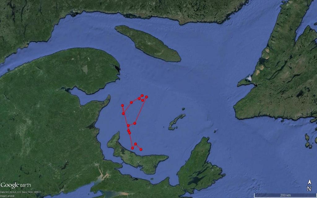
. Three fish tagged with satellite tags (148254, 148255, 148257) spent time in this area of the Gulf during May and June before migrating further to the Atlantic Ocean.")
15 Staging Areas: Two potential staging areas have been noted in the past for kelt; one in the western GOSL, south of Anticosti Island (Figure 2a) and one off the coast of Labrador in the North Atlantic (Figure 2b). Three fish tagged with satellite tags (148254, , ) spent time in this area of the Gulf during May and June before migrating further to the Atlantic Ocean. These fish were alternate spawners. One of these three survived out of the SOBI and traveled into the Labrador Sea. Once there, she showed some diving behaviour up to 50m. A fourth fish (148256) spent time in the more central Gulf before traveling to the SOBI (also an alternate spawner). She exhibited diving behaviour up to 330m in the Labrador Sea. Dives to this depth were not observed in the GOSL area. These movements could be associated with predator avoidance or the fish searching for food sources (reconditioning). Figure 2a. Potential staging area in the Gulf of St. Lawrence. Four fish occupied this space during the months of May and June in
 was recovered after deployment it had washed ashore on the Magdalene Islands. This tag will be refurbished and used in 2016.")
16 Figure 2b. A second potential staging area in the North Atlantic for alternate spawners. One fish was in this location from mid-july to mid-august Tag Recovery In 2015, only one satellite tag (148262) was recovered after deployment it had washed ashore on the Magdalene Islands. This tag will be refurbished and used in Of the ten remaining satellite tags, four failed to transmit entirely and were not recovered, and six successfully transmitted data from fish that survived out of Miramichi Bay and into the Gulf of St. Lawrence and Atlantic Ocean. DISCUSSION In 2015, 55% (6/11) of all satellite tagged kelt successfully transmitted data on fish movements, water temperature, and depth. The five tags that failed to transmit were never detected, however acoustic data showed that all five fish survived out of Miramichi Bay, and three of them to the SOBI (148259, , and ). The failure of satellite tags to transmit could be the result of several factors which include: technical failure, tag damage, or tag obstruction from satellites (i.e.: stuck under 15
17 debris, or caught in the stomach of a predator). Despite these failures, discussions with Microwave Telemetry Inc. (MTI), the manufacturer of these tags, suggest that our return rate of data has been strong compared to other studies. One of the pop-off tags deployed on schedule at the pre-programmed date of August 31 st near Nachvak Fjord in northern Labrador. Initial satellite data suggests this fish moved through the Strait of Belle Isle on July 8 th. Although this date may change with more fine scale analysis, it falls within late June early July, and matches up with the five long-term acoustic tagged fish that passed through in early July as well (24810, 24815, 24816, 14818, and 58538). Given the northern location and late season timing of the transmission from this tag, it is safe to assume this kelt was an alternate spawner on her way to recondition in the cold northern waters of the Atlantic Ocean before returning to spawn in Advanced analysis of the data from this tag is ongoing, and will be used with past and future data to investigate trends in kelt migrations to determine statistically relevant behavioural patterns which may provide significant insight into the ecology of alternate spawning Atlantic salmon. Of the five tags that deployed prematurely (four in the GOSL (148254, , , and , and one off the coast of Labrador (148256)), only one has strong supporting evidence of being predated tag A dive to 330m was observed in early August, with water temperatures around 10 C. At this depth, a sudden increase in temperature was noted, up to 24 C and most likely points to the tag being consumed and resting in the stomach of a predator. The temperature recorded then decreases to 5 C and the tag depth changes to ocean surface levels; four days later the tag began transmitting. Tags and popped after 4 days of constant depth, however a deep dive prior to tag release and the sharp increase in temperature was not seen. This does not mean the fish was not predated, as the tag may just not have been ingested. Tags and both show dives to approximately 50m and drops in temperature to 1-2 C for days prior to tag release. No temperature spike was observed however. Further analysis of temperature and depth data may provide insight as to what species of animal could have consumed these fish. The sample size from 2015 is too small to draw any significant conclusions from, but pooling the data from these fish, along with kelts from the past and future studies that also prematurely deploy in the Gulf may provide 16
18 correlations between survival and water temperature and depth, seasonal commercial fisheries, or predator movements. Determining movements of individual fish requires considerable work and statistical analysis. Tag position is determined by converting daily recorded light intensity and duration to sunrise and sunset timing each day. Positioning is then determined by calculating the marine area that would have those same times for a specific date. Even though this method is effective, it is susceptible to false locations produced by environment conditions. Dense cloud cover during dawn or dusk where light levels are low can give the impression of delayed sunset or early sunrise, therefore changing the position calculated for the location. An initial correction factor can be applied by averaging positions at a specific date with values collected during the previous days. This method provides a simplified improvement to smooth out data, but is still impacted by outlying erroneous locations. In order to correct for this, all positions need to be compared against local weather conditions during the specific date the animal was thought to be in a given area. At this time, simplified tracks of six kelt have been completed and are included in Appendix 1 of this report. These tracks are not considered final and still need further analysis and refinement. 17
")

19 ASF Biologists Jon Carr (left) and Graham Chafe (right) attaching a satellite tag. Satellite tag attached under the dorsal fin. 18


20 APPENDIX 1: Satellite tagged kelt tracks Tag Tag

21 Tag Tag
22 Tag Tag
23 Smolt Production Estimate INTRODUCTION Declining Atlantic salmon runs in the Miramichi River during the 1970 s and early 1980 s marked the beginning of increased conservation efforts for this species. Actions plans were put in place, including the closure of the commercial fishery and the mandatory release of all large salmon by anglers. From the stocks rebounded and numbers were on the rise. After 1992 however, stocks began declining again and have continued to do so over the last two decades. Over recent years, the Southwest branch has outperformed the Northwest branch for adult returns. During the 17 years from , the Northwest system only reached conservation requirements (for sustainability) during two separate years, whereas the Southwest system met requirements for seven of those years. The average conservation requirement from was 103% on the Southwest and 51% on the Northwest. Electrofishing results from both the Northwest and Southwest branches of the river have typically shown healthy numbers of salmon fry and parr. It has been assumed that smolt production in these rivers would reflect these high juvenile numbers and therefore high smolt numbers should be produced, however adult returns do not reflect this trend. In 2011 angling regulations on the Northwest Miramichi were modified to a catch and release fishery to reduce human harvesting mortality on grilse, and in 2015 all New Brunswick Rivers became mandatory catch and release fisheries of all Atlantic salmon due to the continual decline in stocks. The initial policy change on the Northwest River in 2011 has likely reduced the angling mortality rate on the this system since then, compared to the Southwest, but the large adults returning on the Northwest are still subjected to non-angling mortality from First Nations Fisheries Allocations. The Northwest River is also the site of a striped bass spawning ground where bass spawn at the same time as smolt are migrating to the ocean. This has the potential to increase smolt mortality rates through predation. Striped bass are also present in the Southwest branch but not concentrated in high numbers as at a spawning area like the Northwest branch. Smolt population estimates have been carried out in recent years on each branch of the Miramichi River system separately. The MSA has conducted ten years of estimates on the Southwest branch ( ) and three years on the Northwest branch ( ). This year 22
24 marks the second year of a new program that focuses on the river as a whole. The decision to change the program stemmed from concerns that over the three years fishing occurred on the Northwest River too many smolt were being missed in the Cassilis trap net because of washouts (the smolt estimates would be artificially low in such cases). The net needed to be in a location where it could be fished continuously without being damaged or washed out. Tidal waters offer more security from spring freshets so a location in the estuary in Chatham was chosen as a new trap net location. Since this location would count smolts from both the Northwest and Southwest Branches, the tagging was expanded to include the Southwest system and four smolt wheels were installed: two on the Northwest system and two on the Southwest. The purpose of this study is to assess smolt production on the Miramichi River to determine if adequate juvenile production is occurring. An accurate estimation of the total smolt population migrating out of the Miramichi River system to the ocean is a key component to understanding and managing Atlantic salmon in this area. Ocean survival rates of smolt can then be observed in subsequent years as adults return as grilse and salmon and will help guide management decisions to conserve this important stock of salmon. METHODS Study Area The Miramichi River watershed drainage area is approximately 12,000 km 2. The system is divided into two large branches the Northwest and the Southwest. The Southwest system encompasses 2/3 s of the total drainage area, while the Northwest system is smaller occupying 1/3 of the total area. Design The smolt production estimate for the Miramichi River used a two-sample markrecapture study design. Four rotary screw traps (RST s) or smolt wheels were installed in early May. Two traps were located on the Northwest system one on the Northwest River (operated by MSA) and one on the Sevogle (operated by NSPA), and two traps were located on the Southwest system one on the Cains River (operated by MSA) and one on Rocky Brook 23
25 (operated by IP) (Figure 3). The original plan for 2015 was to have a smolt wheel at the mouth of the Dungarvon River on the Southwest system (not the Cains), but due to road damage from ice flows field crews were unable to access this area and the Cains was chosen as a secondary location. The wheels are held in place by a large overhead cable that spans the width of the river. A second cable connects from this main line to the wheel, where two pontoons keep the wheel partially afloat and allow the trap to rotate fully (the current forces the wheel to turn) without hitting the bottom of the river. Any fish entering the trap were funneled through the rotating wheel into a holding box at the back of the trap. The rotating wheel prevented any fish from escaping the box. All fish caught in the live box were collected and sorted. Each species was identified, counted, and released except for smolts. Fork lengths were taken from 25 fish which were then tagged with small, individually numbered streamer tags. Any remaining unmeasured smolts were also tagged. All fish were released after tagging. For the purpose of this study all juvenile Atlantic salmon greater than 100mm (FL) were considered smolt. A single large trap net was installed just upstream of the Centennial Bridge on the Chatham side of the Miramichi River to capture smolt leaving the estuary (Figure 1). Tagged smolt captured at the trap net allows us to get an estimate of the number of smolt moving out of the Miramichi River system. The total smolt run is determined by a ratio of the number of smolt tagged upstream at the smolt wheels, the number of tagged smolt that are recaptured in the trap net, and the number of untagged smolt captured in the trap net. The trap net was fished daily, generally at low tide, and the smolt were sorted from the rest of the species caught. Sub-samples of up to 100 smolt were measured, 20 of which were lethally sampled for length, weight, age, and sex information. All smolts captured were counted and checked for streamer tags. Permits The Navigable Waters Permit from the Department of Transportation, Instream Data Collection Devices Permit from the local Department of Environment, and the Scientific Collection Permit from the Department of Fisheries and Oceans were all obtained prior to starting this project. 24
26 RESULTS Population Estimate The Northwest smolt wheel operated from May 10 th June 1 st. The smolt wheel on the Sevogle operated from May 13 th 31 st. The Cains smolt wheel operated from May 10 th May 21 st, on May 22 nd the water levels had dropped and the wheel was no longer fishing. It was repositioned and began fishing again from May 23 rd 29 th. The Rocky Brook wheel operated from May 8 th June 1 st. A total of 1,965 smolt were tagged in Northwest (801), Sevogle (269), Cains (414), and Rocky Brook (481). The peak of the smolt run for each wheel was as follows: Northwest May 18 th (110 fish), Sevogle May 23 rd & 25 th (53 fish), Cains May 17 th (103) (Figure 4). The trap net operated from May 18 th June 5 th. High east winds, large swells, and poor weather conditions kept crews from fishing the trap on May 20 th, 21 st, 23 rd, 24 th, and June 3 rd. The trap net held up against late spring ice and never had to be lifted, nor did it wash out. A total of 6554 smolt were captured at the trap net, three of which had been tagged upstream. All three tagged fish were from the Southwest River system (one from Rocky Brook and two from the Cains). The fish from Rocky Brook was tagged on May 11 th and recaptured in Chatham on May 18 th. The Cains smolts were both tagged on May 17 th and both recaptured on May 22 nd. Using the survival information from acoustic receivers deployed for our smolt tracking program, the survival rate of smolts to Chatham was 40%. Applying a 60% mortality rate to our population estimate (using the Peterson Model) gives a smolt estimate of 1,717,148 (95% CI 582, 743 5,151,444). This equates to 3.18 smolts/100m 2. Sampling Data The male to female sex ratio was 1:1.6, respectively. Average fork length for females was 12.9cm (± 0.98cm) and for males was 12.5cm (± 0.99cm) (Figure 5a). Average weight for females was 20.3g (± 4.34g) and for males was 19.1g (± 4.58g) (Figure 5b). 25

27 Number of Smolts (#) 10 km Figure 3. Locations of the four smolt wheels (red dots) operating in 2015 and the trap net in Chatham (yellow dot) NW Sevogle Cains Date Figure 4. Daily smolt counts at the three wheels operated by MSA and the NSPA during May of Peak numbers occurred on the Northwest on May 18 th, on the Sevogle on May 23 rd and 25 th, and on the Cains on May 17 th. 26
28 Average Weight (g) Average Length (cm) Male Female Figure 5a. Average fork length (cm) for male and female smolts sampled at the Chatham trap net in the spring of Male Female Figure 5b. Average weight (g) for males and female smolts sampled at the Chatham trap net in the spring of
29 DISCUSSION The Miramichi River needs 1.8 million smolt migrating to the ocean every year in order to sustain a healthy adult population roughly 1.2 million from the Southwest branch and 600,000 from the Northwest. The standard estimate is 3.0 smolt/100m 2. In 2014 the trap net was relocated to Chatham, however no estimate could be produced because of the high volume of fish caught too many for our crews to sample, and the net had to be dumped out. The three years of data from the Northwest system before that have shown variable and sometimes conflicting results; in 2011 and 2013 smolt production exceeded 3.0 smolt/100m 2 and in 2012 was estimated at only 2.0 smolt/100m 2. Difficulties with equipment damage from weather and high water levels occurred during these years and may have impacted estimates. Earlier data from on the Southwest system indicated that smolt production estimates exceeded requirements for all years except Even with these high smolt estimates the adult returns have continued to decline. For the 2015 smolt estimate program, alterations were made to our trap net to reduce the volume of fish the net could carry (in the hopes of minimizing the number of fish caught so crews could actually count them all in a day). The leader from shore was also shortened, with only half of the panels dropped in the river. These adjustments were successful, and a much more manageable number of fish were caught this year. Our recapture numbers were very low however (3 tags or 0.15% of total marks), and this caused our estimate to be highly inflated (overestimated). Typically, a 10% mortality is assumed with tagging studies, but with the data available to us from our smolt tracking program, a 60% mortality rate was actually observed to the Chatham area, and that percentage was applied to our estimate, which decreased the number substantially. We also were not able to fish the trap on five separate days because of high east winds which caused large (>2-3ft) swells, making conditions unsafe for the field crews. The trap net remained fishing during this time, and although the number of fish inside never reached levels similar to 2014, this extra time in the net adds stress to the fish trapped in it for the extended period. 28

30 A new strategy is in place for the smolt estimate program in The MSA plans to relocate the trap net back to the Northwest River because of the problems that have occurred at the Chatham location the last two years. The trap net will be installed at the mouth of Stewart Brook near the Miramichi Salmon Conservation Centre (MSCC), which is downstream of Cassilis, and in an area where trap nets are not impacted by freshets or high winds. This should allow the trap to be fished safely every day and not have to be lifted because of weather conditions. This adjustment in the smolt estimate program is part of a larger project which is seeking funding from the Collaboration for Atlantic Salmon Tomorrow (CAST) initiative to help conserve and improve Atlantic salmon returns on the Miramichi River. The new trap net location will serve as a recapture platform for our smolt estimate program on the Northwest River and also as a collection point for wild smolts to be transferred to the MSCC as part of the adult rearing program also associated with CAST. Chatham trap net 29
31 Smolt Tracking INTRODUCTION Juvenile Atlantic salmon which have undergone physiological changes to transition from freshwater to saltwater are referred to as smolt. These salmon have begun a process known as smoltification where they exhibit negative rheotaxis (consistent downstream movement), silvering of the body, and a decrease in body condition due to increased growth in length. Smolts migrate from natal tributaries and rivers or from pre-smolt overwintering staging areas to estuaries as freshwater temperatures start to rise in the spring. On the Miramichi River smolt movements typically start between late April and early May and conclude in late May or early June. During this time the majority of the total smolts from a river or tributary will migrate within a short window of five to six days. This peak movement is often observed during times of high water discharge following a rain event and when water temperatures are near 10 C. Upon entering brackish water, these fish may be required to stall downstream movements to allow for physiological acclimation to the salt water. Striped bass (Morone saxatalis) are a large generalist fish species native to the Northumberland Strait and Gulf of St. Lawrence (GOSL). Over the past 5 years their population numbers have increased in the Miramichi Estuary. The only known location of successful spawning for the entire GOSL population occurs between May and June in the upper portion of the tidally influenced water of the Northwest Miramichi River. During this time a large number of mature, breeding striped bass from various locations throughout the Northumberland Strait and Gulf region will move into this area for several weeks. The timing of the striped bass migration closely coincides with the salmon smolt migration. This spatial and temporal overlap raise concerns regarding the survival of Northwest Miramichi salmon smolts. Striped bass are opportunistic feeders and cases of smolt predation on both Atlantic and Pacific salmon species (Oncorhynchus spp.) have been documented to varying degrees throughout North America in both native and non-native ranges of the species. With the recent decline in adult salmon returns to the Northwest Miramichi River, there is potential that increased levels of predation may greatly impact the survival rates of the smolts, 30
32 therefore reducing the number of smolts leaving the Miramichi system to a level that also reduces the number of adults returning in subsequent years. The use of acoustic technology is an effective way to estimate the survival of a fish population in a river or estuary. Fish implanted with acoustic transmitters are identified as they move through the detection field of an acoustic receiver. For Atlantic salmon smolt, the placement of multiple receivers throughout a river system allows for the detection of tagged fish as they move downstream to the marine environment. Changes in the percentage of tagged fish detected moving downstream through a river can indicate the level of survival through the system. The placement of receivers between barrier islands in an estuary allow for estimates on the percentage of tagged fish which survived to the ocean. As a compliment to the Atlantic Salmon Federation s smolt tracking program to estimate the survival of smolts from the Southwest branch of the Miramichi River, an acoustic tagging study was carried out on the Northwest branch during the 2015 smolt migration to determine survival rates throughout the river and estuary. METHODS Study Area The Northwest Miramichi watershed drainage area of 3,950km 2 makes up approximately one third of the total watershed of the Miramichi River. The Northwest Miramichi basin includes two major river systems: the Little Southwest River (1,342km 2 ) and the Northwest Miramichi River (2,078km 2 ) which merge in a delta at the head of tide. The Northwest Miramichi River includes a large tributary, the Sevogle River, which has a drainage area of 799km 2. Tagging Atlantic salmon smolt were captured by a rotary screw trap (RST) on the Northwest Miramichi River immediately upstream of the mouth of Trout Brook. Only fish greater than 13cm were held for tagging (to allow for room in the body cavity for the transmitter). The fish were held in live boxes off the shore until the following morning (to allow for digestion and 31
33 therefore easier tag insertion) when they were transported to the tagging location in an x-actic tank on a truck. The smolts were tagged at Miner s Bridge, approximately 27km upstream of the RST. Prior to surgery the fish were placed in a clove oil bath for several minutes until equilibrium was lost and movement was minimal. Vemco V8 acoustic tags were used during surgery. The tag was inserted by making a small incision on the ventral surface on the fish, offcenter, between the pectoral and pelvic fins. The incision was closed with two sutures and the fish placed into a recovery box (live well) for observation. Time out of the water for this procedure was 2 3 minutes per fish, with water passed through the gills during surgery. The smolts regained equilibrium within one hour after the surgery and were then released. Receiver Placement A total of 14 Vemco VR2w acoustic receivers were placed throughout the tidally influenced portions of the Northwest and Southwest Miramichi River. An additional three receivers were placed on the main stem of both the Northwest and Southwest (new in 2015) rivers to detect in-river movements and survival rates. Receivers were also placed to form detection gates between openings at barrier islands near the mouth of Miramichi Bay at Neguac Beach, Portage Island, and Huckleberry Gully. An additional receiver line in the Strait of Belle Isle (SOBI) was deployed in 2015, 3.5km north of the original line so that two lines of detection were present to increase the chances of tag detections in this area (Figure 6a&b). 32

 across the Strait of Belle Isle in 2015.")
34 10km Figure 6a. Acoustic receiver locations (red dots) in the Miramichi River and Bay in Smolt tagging and release locations are represented by a blue dot Miner s Bridge on the Northwest branch and Rocky Brook on the Southwest branch. SOBI Gulf of Saint Lawrence Miramichi 220km Figure 6b. Acoustic receiver locations (red lines) across the Strait of Belle Isle in A second line was added north of the original line in The lines are 3.5km apart. Suspected fish movement paths are indicated with a black arrow. 33
35 RESULTS Northwest River From May 20 th 26 th, a total of 80 smolts were captured at the Northwest smolt wheel and transported upstream to the tagging site located at Miner s Bridge. Of the initial 80 fish tagged, 71 of them (89%) were detected on the first receiver at Kingston Lane, however at the head of tide (HOT) in Cassilis, only 63 of the 80 fish (79%) were detected, indicating a 21% mortality rate from the tagging location to HOT. Another 23% of the fish were lost between Cassilis and Nelson. Survival in the main channel of the river from Nelson to Loggieville was 69% of the remaining fish, and 39% from the tagging location. Only 29 fish (36%) of the smolts tagged at Miner s Bridge survived out of the estuary (past the barrier receiver lines), and 21% to the SOBI (Figure 7a). Southwest River On May 20 th & 21 st, 80 smolts captured at the Rocky Brook smolt wheel were tagged and released. Of the initial 80 fish tagged, 59 (74%) of them were detected at the first receiver in Boiestown and the same number at the HOT in Millerton. At the second receiver in Doaktown however, 64 tags (80%) were detected indicating poor receiver reception in Boiestown. The mortality rate from the tagging location to the HOT was 26%. Another 29% of the fish were lost between Millerton and Nelson. Survival in the main channel of the river from Nelson to Loggieville was 94% of the remaining fish, and 43% from the tagging location. Only 32 fish (40%) of the smolts tagged at Rocky Brook survived out of the estuary (past the barrier receiver lines), and 14% to the SOBI (Figure 7b). In total, 38% of the smolts leaving the entire Miramichi River survived to exit the estuary, and 18% survived to the SOBI. 34
36 Number of Smolt Detected Number of Smolt Detected Receiver Location (distance from tagging site) Figure 7a. Survival numbers of acoustic tagged smolts from the Northwest River at each receiver deployed in the Miramichi River, Bay, and the SOBI in The highest percentage of mortality occurred between Cassilis and Nelson (18 fish/23%), marked in grey Receiver Location (distance from tagging site) Figure 7b. Survival numbers of acoustic tagged smolts from the Southwest River at each receiver deployed in the Miramichi River, Bay, and the SOBI in The highest percentage of mortality occurred between Millerton and Nelson (21 fish/29%), marked in grey. 35
37 DISCUSSION Survival numbers from the 2015 tagging study are less than desirable for the Miramichi River, however they were better than numbers recorded in The fish that successfully survived tagging (a 10% mortality rate is assumed for tagging studies) and were detected exiting Miramichi Bay was only 36%. The highest areas of loss on the Northwest were between the head of tide at Cassilis and Nelson (18 fish/23%) where striped bass are most prevalent, and from the tagging location at Miner s bridge to Cassilis (17 fish/21%) (Figure 2a). The highest survival rate was observed between Loggieville and the estuary receivers, as only 2 fish (3%) were lost. For the Northwest River in total, 0.44 smolt/km were lost. On the Southwest branch the highest areas of loss were between the head of tide at Millerton and Nelson (23 fish/29%) and from the tagging location at Rocky Brook to Millerton and the estuary to the SOBI, both at 21 fish lost and 26% mortality (Figure 2b). The highest survival rate was observed between Nelson and Loggieville, and between Loggieville and the estuary, with each section only losing 2 fish each (2.5%). For the Southwest River in total, 0.26 smolt/km were lost. The second receiver line placed in the SOBI in 2015 has shown that the first line did not always pick up all the fish moving through the Strait. Of the 17 smolts that survived to the SOBI from the Northwest River, three fish were picked up by the first line, six on the second line, and eight on both lines. Of the 11 fish that survived to the SOBI from the Southwest River, four were picked up on the first line, one on the second line, and six on both lines. This error percentage can be modeled and applied to smolt tracking data from previous years to produce a more accurate estimate than originally thought. It is important to note that there are multiple sources of smolt predation within the tidally influenced waters of the Northwest Miramichi River, and that at this time it is not possible to quantify the level of tagged smolt mortality that can be attributed to striped bass. Avian predation from mergansers, gulls, and cormorants, as well as fish predation by trout, tomcod, or reconditioning kelt could all contribute to natural smolt mortality in the river. In order to narrow the sources of predation, detailed study of individual tag data is required. For 36
. In 2016 a new Vemco acoustic predator tag will be used in this study, along with regular acoustic tags.")
38 2015 data, further analysis will be carried out by the Atlantic Salmon Federation to look at the behaviour of the fish which did not reach Miramichi Bay, specifically whether fish exhibited atypical movements likely attributed to another animal (i.e.: consumption). In 2016 a new Vemco acoustic predator tag will be used in this study, along with regular acoustic tags. The predator tags change their signal code ID if a fish is consumed, but will still be picked up by the same receivers used in previous years. With this information we will be able to monitor if, when, and where a fish is predated upon. In past years, the smolts tagged were all released on the same day, which left us unable to determine if changes in survival occur over the duration of the juvenile migration. On the Northwest River, striped bass are known to stage in distinct areas before, during, and after spawning. The changing position of the bass over the course of the smolt run may influence their spatial overlap with juvenile salmon, changing the likelihood of predation. The feeding behaviour of striped bass while they occupy these areas is also not fully understood. In 2015, tagging efforts were staggered on the Northwest River over multiple days to allow for detection of movement and survival changes over time. This information would then be available for comparison to striped bass tracking research, conducted by DFO, to determine the times of greatest overlap between the species. Research of striped bass stomach contents, which is carried out over several weeks by DFO, could be used to determine if changes in the occurrence of smolts on the stomach contents matches with peaks in the smolt migration. This combined research should allow for a more precise understanding of the interaction between the species. Efforts will be made again in 2016 to spread the tagging out over multiple days to try and determine temporal overlap between smolts and striped bass. Acoustic tagged smolts recovering after surgery 37
39 Salmon Fry and Trout Stocking INTRODUCTION Stocking Atlantic salmon first-feeding fry can improve the juvenile production capacity of the Miramichi River by targeting areas that are under-seeded or not accessible to wild spawning adults. An electrofishing survey is carried out each year by the Miramichi Salmon Association (MSA) to assess areas of the river that are lacking adequate numbers of fry or parr. Low fry or parr numbers could be the result of multiple factors, including: poor adult returns, barriers to adult movement into upper stream reaches (i.e.: beaver dams), environmental events such as ice scouring that destroys redd s, or less than optimal water conditions. Areas with zero/minimal fry present will be targeted to stock and efforts will also be made to identify and remove any impediments to natural spawning. The majority of these areas are located in small tributaries and the headwaters of the Miramichi River. Small brooks and streams often have good quality habitat and lower numbers of predators than larger downstream locations. These narrow waterways may be inaccessible however, because of barriers or decreased water levels in low flow years. Juvenile abundance electrofishing surveys and smolt estimates are used to aid in determining specific tributaries that may need additional stocking. Since it is impossible to stock every small stream in the Miramichi with a limited numbers of fish, it is important to place hatchery salmon fry into streams that will benefit most from their introduction. Stocking salmon fry into a tributary with high salmon fry abundance could negatively impact those fish by increasing the level of competition for food resources. To avoid this, any site containing more than 100 fry/100m 2 is not considered for stocking as it appears to reflect a healthy natural population. Sites with less than 50 fry/100m 2 are considered candidates for further stocking. The absence of fry at an already stocked site may indicate that the site does not contain the appropriate habitat or it may have too many predators. Prior to 2010, fall fingerlings were stocked and identified by an adipose clip (removal of the adipose fin). In 2010 the MSA shifted the focus from Atlantic salmon fall fingerlings to stocking first-feeding salmon fry in the early summer. These fry are incubated as eggs on 38
40 unheated brook water to ensure that the rate of egg development is similar in timing to that of wild eggs. The stocking of fry over fingerlings has several benefits, including the reduced risk of fish contracting a pathogen while in artificially high densities at the hatchery, and the improved capacity to develop wild behaviour tendencies at a younger age. First-feeding fry are stocked out in June/July at an average size of 0.5g which makes fin clipping impossible. However, there are still locations that raise fall fingerlings for stocking purposes. Atlantic salmon fry, young of the year brook trout, and yearling brook trout were raised this year in satellite rearing stations run in collaboration with J.D. Irving Ltd., the Miramichi Headwaters Salmon Federation, and Rocky Brook Camp & Barbour s. The objective of this program is to improve Atlantic salmon production in the headwaters of the Miramichi watershed. METHODS Adult salmon were collected from September to mid-october 2014 for broodstock and held at the Miramichi Salmon Conservation Centre (MSCC). The fish were kept separated based on their river of origin. Once ripe, female salmon were stripped of their eggs, which were then fertilized by a male salmon from the same river. Immediately following spawning, the adults were released back into the wild via Stewart Brook, which runs beside the MSCC. Eggs were incubated on brook water until the eyed stage, when dead eggs were removed weekly. Eyed eggs were transferred to incubation boxes in preparation for hatching. After hatching, fry were fed a formulated salmonid diet (Corey 0.7CR/EWOS #1CR) for approximately 4 weeks until stocking. All salmon fry were stocked in their river of origin ( river specific stocking ). Stocking sites were selected based on low juvenile densities found at the exact or nearby locations from the previous year s electrofishing results and in tributaries that typically have low juvenile production (i.e.: Cains and Little Southwest). Additional salmon fry were taken to satellite rearing sites for continued growth before stocking. 39
. The Northwest system received 112,819 fry and the Southwest system 118,494 (Table 2).")
.")
41 RESULTS Approximately 231,313 first-feeding Atlantic salmon fry were stocked into 80 sites in seven tributaries of the Miramichi River (Figure 8a&b). The Northwest system received 112,819 fry and the Southwest system 118,494 (Table 2). An additional 21,000 fry were taken to satellite holding tanks for future release by local conservation groups (Table 3). Additionally, 40,000 brook trout parr and 1,200 yearlings were distributed to two satellite tank rearing locations (Table 4). Stocking fish on the LSW 40
42 Table 2. Distribution of first-feeding Atlantic salmon fry from the Miramichi Salmon Conservation Center in Branch Stock Origin Site # of fish Latitude Longitude Northwest Sevogle Johnston Brook Northwest Sevogle Travis Brook Northwest Sevogle Clearwater Brook Northwest Sevogle SEV SB Northwest Sevogle SEV SB Northwest Sevogle SEV branch Northwest Sevogle SEV NB Slack Lake Northwest Sevogle SEV NB Northwest Sevogle SEV NB Northwest Sevogle SEV NB Northwest Sevogle SEV NB Bear Lake Northwest Sevogle Sheephouse Road Northwest LSW North Pole bridge Northwest LSW Smith Forks Northwest LSW Squaw Barron Brook Northwest LSW County Line Brook Northwest LSW LSW Northwest LSW LSW Northwest NW Crawford Northwest NW Crawford Northwest NW NW SB Northwest NW NW SB Northwest NW NW SB Northwest NW NW NB Northwest NW NW NB 2 (Bill Gray Mtn) Northwest NW Trout Brook Northwest NW Trout Brook Northwest NW Pat's Brook Northwest NW Pat's Brook Northwest NW Stoney Brook Northwest NW NW Main Northwest NW Mountain Brook Northwest NW Little River Northwest NW Little River Northwest NW Little River Southwest Rocky Brook LL Road Southwest Rocky Brook Below Fish Brook Southwest Rocky Brook Brown Lake Bridge
43 Branch Stock Origin Site # of fish Latitude Longitude Southwest Juniper Juniper Brook Southwest Juniper Teague Southwest Juniper Teague Southwest Juniper Teague Southwest Juniper Elliott Brook Southwest Juniper Elliott Brook Southwest Juniper Elliott Brook Southwest Juniper Little Teague Southwest Juniper Little Teague Southwest Juniper MSW Branch Southwest Juniper MSW Branch Southwest Juniper White Rapids Brook Southwest Juniper North Branch Hudson Brook Southwest Juniper South Branch Hudson Brook Southwest Juniper Main Hudson Brook Southwest Juniper Smith Lake Outlet Southwest Juniper Hallihan Brook Southwest Juniper Brandy/Mersereau Brook Southwest Juniper Zack's Brook Southwest Juniper Morse Brook Southwest Juniper Four Mile Brook Southwest Juniper Fowler Meadow Brook Southwest Juniper Ledbetters Brook Southwest Juniper Davis Landing Brook Southwest Juniper Big Hole Brook Southwest Juniper South Branch Big Hole Brook Southwest Juniper North Br. Bartholomew River Southwest Juniper South Br. Bartholomew River Southwest Cains Tyler's Camp Southwest Cains Mahoney Brook Southwest Cains Brad's Camp Southwest Cains Salmon Brook Southwest Cains East Branch Sabbies Southwest Cains West Branch Sabbies Southwest Cains East Branch Six Mile Southwest Cains West Branch Six Mile Southwest Cains Cains tributary Southwest Cains Otter Brook Southwest Cains North Cains
44 Branch Stock Origin Site # of fish Latitude Longitude Southwest Cains North Cains Southwest Clearwater Clearwater Bridge Southwest Clearwater Christiana Pool Table 3. Distribution of first-feeding Atlantic salmon fry to satellite holding tanks for continued growth and stocking. Stock Origin Organization # of fish Latitude Longitude Juniper Miramichi Headwaters Salmon Association Clearwater J.D. Irving Ltd Clearwater MSA and Clearwater and Rocky Bend Camps Table 4. Distribution of brook trout parr and yearlings to satellite tanks for continued growth and stocking. Stock Origin Organization # of fish Latitude Longitude Beadle Brook J.D. Irving Ltd Moose Lake Miramichi Headwaters Salmon Association


45 Sevogle Northwest Little Southwest 1:250,000 (a) Clearwater Rocky Brook Juniper Southwest Cains 1:350,000 (b) Figure 8. Stocking sites of salmon fry distributed on the Northwest (a) and Southwest (b) Miramichi Rivers in
46 Juvenile Electrofishing Assessment INTRODUCTION The Miramichi Salmon Association (MSA) continued its electrofishing program in 2015 to assess juvenile Atlantic salmon populations in the smaller tributaries of the Miramichi River watershed. The MSA also worked co-operatively with the Department of Fisheries and Oceans (DFO) Science Branch on another survey using historic baseline sites that are monitored on an annual basis to assess Atlantic salmon juvenile abundance on the Miramichi River system. Both electrofishing surveys target Atlantic salmon and brook trout juveniles, but other fish species are often collected as by-catch. In this report, Atlantic salmon juveniles are listed as fry and parr, with the parr consisting of 1+ and 2+ age classes. Wild salmon fry (0+) are typically less than 60mm in length in late summer. Wild parr vary in size by site, but are grouped together in length by year class and generally do not exceed 120mm. There is typically a higher abundance of fry than parr, as fewer salmon are present in successive age classes due to mortality and predation. If this trend is not observed, it could be viewed as an indication that fry survival is low and should be investigated. Electrofishing sites in both surveys are generally 3 rd or 4 th order streams and are tributaries to major rivers where salmon historically spawn; however sites may also include some main river locations. The tributary streams are the major focus of the MSA electrofishing program as they are considered feeder streams to the major rivers and can be under-seeded with juvenile salmon in the event adults were unable to access these areas to spawn (i.e.: barriers, low water levels). Generally, swift moving water less than 60cm deep with gravel or rocky substrate is characterized as juvenile salmon habitat. Adult salmon migrate as far upstream as possible to spawn, but juveniles in their first, second, or third year can move around quite extensively in search of food, to avoid predation, or to seek out over-wintering habitat. During the warm water periods in the summer months, juveniles (parr more often than fry) also move throughout the river seeking cold water refuge. The main objectives for the 2015 annual electrofishing program were to: 45
47 1. Evaluate previous year s beaver dam removal success: The Miramichi beaver dam management program resulted in 167 dams breached in 2014 over the entire Miramichi watershed. Upstream locations from where some of these dams were removed were a large focus for electrofishing crews in 2015 to determine if adult salmon were able to access these areas for spawning. 2. Evaluate spring stocking success: Electrofishing surveys were conducted on stream stretches stocked with first-feeding fry in late June and early July of 2014 to assess fry survival rates. Stocked location densities that are higher than unstocked locations are considered to reflect successful survival of hatchery fry following stocking. 3. Determine future stocking sites of spring first-feeding fry: Broodstock are collected annually from major rivers/streams in the Miramichi watershed and spawned at the Miramichi Salmon Conservation Centre (MSCC). The fry produced are returned to their native river system. In order to achieve effective stocking results in 2016, electrofishing surveys were carried out during the summer of 2015 to identify high quality juvenile habitat (gravel, or rocky substrate) with low fry and parr densities. Determining wild densities allows for avoidance of overstocking areas with healthy juvenile densities and for the targeting of tributaries that are naturally underseeded or devoid of juvenile salmon. Any site containing more than 50 fry/100m 2 is not considered for stocking as it appears to reflect a healthy natural population, where sites with densities below this value are considered for stocking. 4. Estimate juvenile abundance using baseline locations: Juvenile Atlantic salmon abundance surveys were conducted in partnership with DFO. These surveys monitor baseline sites, some of which have been electrofished for over 40 years, and allow for the estimation of absolute juvenile abundance in these areas. 46
48 METHODS Electrofishing is the use of electricity for the active capture of fish; electricity is generated by a battery located on the backpack of the electrofisher. An anode wand (positive) and cathode tail (negative) are placed in the water. The electric current moving between the wand and tail produce an electric field which can render fish immobile (galvanonarcosis) or cause them to move towards the electrofisher (galvanotaxis). A crew of three people wearing water tight chest waders and rubber gloves enter the site facing upstream. While the electrofisher stuns the fish, the other crew members collect the fish with dip nets and a small seine net as the fish are drawn up to the water surface by the electrical current. The fish are placed in a bucket of water and held until the site in completed. There are two methods for measuring density in a given area: catch-per-unit-effort (CPUE) and closed-site depletion (or removal). The MSA survey for assessing headwater areas for stocking uses the CPUE method exclusively. CPUE sweeps are continued back and forth along the stream from bank to bank until a predetermined amount of time has elapsed on the electrofisher, approximately seconds depending on the site. CPUE calculations are standardized so all densities reflect a 500 second sampling time and 100m 2 area to allow for comparisons. The crew then samples the captured fish on shore for length and abundance counts for each species. The fish are then released back into the stream. The depletion method, only performed during the MSA/DFO juvenile assessment, is done by capturing all fish from a measured section of stream rather than the timed CPUE method. A 200m 2 section of stream is measured and barricaded with fine nets at the upper and lower ends of the site. This closed site is then swept three to four times, removing all fish or until an acceptable reduction in fish occurs (usually four sweeps). This method produces an actual density for a known area and is used to calibrate the formula for the timed CPUE method. All fish are identified to species and lengths and weights are recorded. Substrate type (rocky, gravel, etc.), stream type (riffle, run, etc.), water and air temperature, site dimensions, and GPS locations are recorded. 47
49 RESULTS A total of 87 electrofishing sites were assessed by MSA and DFO field crews between August 7 th and October 21 st, 2015 on the Miramichi River system. MSA alone surveyed 29 sites, while MSA and DFO worked together on 58 sites. Beaver dam removal success from previous year In total, 76% (22/29) of the sites electrofished in 2015 focused on areas upstream of beaver dams removed in 2014 (18 on the Southwest and 4 on the Northwest). Nine of these sites had fry present, with fry densities ranging from 0 to 74.2 fry/100m 2 (Table 5). Sites with fry present were in lower to midstream reaches of the tributaries, suggesting adult salmon did make it past dams that were breached in the lower sections, but were not able to access the more upstream habitat. Beavers can repair active dams within a 24 hour time frame, so the timing of notching/removing dams is crucial in helping the fish access ideal spawning habitat. Field crews can only access and remove so many dams per day and the efficiency of the beavers in repairing them can still pose problems for adult salmon migrating upstream to spawn. Evaluating spring stocking success Only seven sites (of 29) were surveyed to assess the previous year s stocking success because of the large focus put on surveying areas upstream of beaver dams removed in Of these seven sites, five of them contained parr and four of those had greater than 5 parr/100m 2 (Table 6). The high survival of first-feeding fry at stocked sites can help to increase the overall juvenile salmon production in the river, therefore the MSA will continue to stock first-feeding fry in the future. Determine future stocking sites of spring first-feeding fry: Many of the sites surveyed to assess beaver dam removal success from 2014 were good quality habitat for juvenile Atlantic salmon. Only nine of the 22 sites surveyed contained fry in 2015, which leaves 13 sites available for potential stocking locations in 2016 (Table 5). 48
50 Table 5. Salmon fry abundance assessments calculated using the CPUE method for 22 sites electrofished in 2015 by the MSA upstream of beaver dams removed in River Site Fry/100m 2 MSW Betts Mills Brook (upper) 0.0 MSW Betts Mills Brook (middle) 0.0 MSW Betts Mills Brook (lower) 3.6 MSW Big Hole Brook (upper) 28.1 MSW Big Hole Brook (middle) 0.0 MSW Big Hole Brook (lower) 0.0 MSW Crooked Bridge Brook 0.0 MSW Porter Brook (upper) 0.0 MSW Porter Brook (lower) 28.8 MSW Burntland Brook 0.0 MSW Mckinley Brook 0.0 NW Below bridge on CI road 5.5 NW Bellefond 0.0 NW Little River (upper) 7.0 NW Little River (lower) 13.9 Cains Muzzeroll Bk (bridge on GL road) 6.6 Cains Otter Brook (below bridge) 0.0 MSW South branch in Juniper above Foreston bridge MSW South branch in Juniper above Foreston bridge MSW Elliott Brook (upper) 0.0 MSW Elliott Brook (lower) 0.0 MSW Big Teague 0.0 Table 6. Juvenile abundance assessments calculated using the CPUE method for 7 sites electrofished by the MSA to identify stocking success from River Site Parr/100m 2 Cains Sling Dung Brook 17.0 Cains McKinley Brook 9.7 NW Pats Brook 1.1 MSW Moores Donnelly Brook 6.8 MSW Burntland Brook 1 (main) 8.7 MSW Burntland Brook 2 (west branch) 0.0 MSW Burntland Brook 3 (east branch)
51 Juvenile population assessment survey (MSA/DFO) From August 24 th to September 24 th 2015, a total of 58 baseline sites were electrofished in several tributaries as part of the MSA/DFO cooperative program. Preliminary results from the assessment revealed high fry densities at many sites in both the Northwest and Southwest Miramichi Rivers, as 60% (35/58) of all sites contained greater than 30 fry/100m 2 (Fig 9a&b). No site contained zero fry and 40% (23/56) of sites had between 30 and 50 fry/100m 2. Parr densities were high (>20 parr/100m 2 ) at 48% (28/58) of sites, and only 5% (3/58) of sites contained zero parr (Fig 9c&d). 20 km >70 9(a). Northwest Miramichi fry densities
52 20 km >70 9(b). Southwest Miramichi fry densities >30 9(c). Northwest Miramichi parr densities
53 20 km >30 9(d). Southwest Miramichi parr densities Figure 9: Preliminary juvenile density results from the 2015 DFO/MSA annual electrofishing program (a) fry densities at sites on the Northwest Miramichi River system, (b) fry densities at sites on the Southwest Miramichi River system, (c) parr densities on the Northwest Miramichi River system, (d) parr densities on the Southwest Miramichi River system. Fry densities range from 1, 2-29, 30-49, 50-69, and >70 per 100m 2. Parr densities range from 1, 2-10, 11-20, 21-30, and >30 per 100m 2. 52
54 Cold Water Pool Restoration INTRODUCTION Pools that are located directly downstream of cold water brooks can be critically important habitat to adult and juvenile salmon during warms water event in the main stem of a river. The presence of these pools creates areas of thermal refugia during times of high water temperatures, where large numbers of salmon and trout, of various life stages, can hold position until surrounding water temperatures decrease. Without isolated pockets of cold water, these fish would be forced to remain exposed to warm water conditions that lead to physiological stress and potential mortality. With the current understanding of climate change science, the Miramichi watershed is likely to see an increase in the frequency, intensity, and duration of warm water events during the summer, particularly in the lower reaches of the river which are less influenced by colder groundwater sources. The Miramichi Salmon Association has identified these pools as habitat of significant value in protecting adult and juvenile salmon. Pools within a river can become degraded in quality from a variety of natural and anthropogenic sources. Regardless of the cause, the degradation of a salmon pool typically reduces the number of fish which would have previously been found in this water. In the case of cold water pools however, fish will still attempt to hold in these areas during warm water events despite reduced habitat quality (shallow water, changes in water flow or substrate composition) to avoid thermal stress. Salmon that use this habitat may become more exposed to predation, poaching, or reduced benefit of cold water due to changes in stream flow. RESULTS The MSA completed restoration work on four brooks in 2015: Doak Brook and Indiantown Brook on the Southwest and Otter Brook and Pat s Brook on the Northwest. Doak Brook This brook enters the SW Miramichi River on the right (south) bank and flows into relatively deep water. The mouth of the brook has been widening over time, which has resulted 53


55 in reduced energy flow and inhibited the brook s cold water from reaching far enough into the river where the salmon prefer to hold in deeper water during the low flow and increased temperature months in the summer. A rock toe was installed at the mouth of the brook, to increase the energy, along the right bank. A nature-like point bar was also installed on the downriver side of the confluence which will direct cold water into the deeper area of the river where the salmon hold. An embedded rock toe was also installed to help the brook transition into the river. The habitat enhancement work was completed on September 14 th, with further enhancement following on September 26 th with the installation of a large cement pad boat ramp. This ramp will prevent tire spinning and erosion when boats are launched in this area, which is located within the cold water plume of the brook. New boat ramp Point bar at Doak Brook 54

56 Indiantown Brook This brook is located in Quarryville, an area in the lower stretch of the river system, and flows from the left (north) bank and enters the Miramichi River in a deep area, creating a cold water refuge for Atlantic salmon during warm water periods. The site is easily accessible, rendering it susceptible to predation and poaching. To enhance the habitat features, boulder clusters were installed in the existing pool. These clusters will cause flow separation around the rocks, which forms eddies. These eddies diffuse sunlight, providing overhead cover for fish. This altered flow also generates scour that form pockets of deeper water and promote settling of coarse substrate which improves substrate diversity. Such features provide ideal conditions for juvenile and adult salmonids. These boulder clusters will also discourage poaching efforts, as fish will not be as easily spotted and nets will no longer sweep cleanly through the pool. The habitat enhancement work was completed on September 17 th. Rock clusters installed at Indiantown Brook 55


57 Otter Brook This brook is located 6.5km downstream of Catamaran Brook and enters the Little Southwest (LSW) Miramichi River on the right (south) bank. The LSW is very shallow in this area during typical low summer flows, and the cold water plume created by the brook is known to provide thermal refuge for juvenile salmon. Enhancing the plume will transform the area into a refuge for adult Atlantic salmon as well. The water depth was increased at the mouth of the brook by installing a rock v-weir upstream in the LSW to concentrate flow and encourage scouring at the mouth of Otter Brook. The v-weir was set at an elevation so as to create scour and direct flow from the shallow river into a concentrated area where the cold water meets the river. Rock spurs were also installed downstream of the confluence to keep the cold water plume turned away from the shallow riverbank and to help scour and maintain deeper water in the refuge zone. A row of embedded boulders were placed near the outer edge of the cold water plume so in summer low flows, cold water from the brook is able to concentrate in the scoured area without mixing with warm river water. The habitat enhancement work was completed on September 16 th. Enhancement work on Otter Brook 56 Rock weir completed


58 Pat s Brook This brook is located 6.8km upstream of Trout Brook and enters the Northwest Miramichi River on the left (north) bank. The river is shallow in this area during typical low summer flows and the cold water plume created by the brook is known to provide thermal refuge for juvenile salmon. A rock v-weir was installed upriver set at an elevation that will create scour at the mouth of the brook. This will direct flow from the shallow river into a concentrated area where cold water meets the river. Channel material was removed downstream of the v-weir to encourage flow direction and create greater depth in the refuge. Rock spurs installed with the v-weir will help keep the cold water plume turned away from the shallow riverbank and directed into the deeper pool. The habitat enhancement work was completed on September 28 th. Pat s Brook before Pat s Brook after 57

59 Two more brooks have been identified by the MSA for habitat enhancement work (Figure 10). Parks Brook on the LSW was surveyed in 2015 and restoration work is expected to occur in Salmon Brook on the Cains River will be surveyed in 2016 and work completed in 2017, subject to funding. Figure 10. Locations of brooks for habitat enhancement work in 2016 and potentially Parks Brook is located on the LSW (light blue) and Salmon Brook is located on the Cains (orange). 58
60 Beaver Dam Management INTRODUCTION Beaver dams are known barriers to adult Atlantic salmon migrating upstream to spawn, blocking access to habitat in the upper reaches of brooks and streams. Female salmon have been observed below beaver dams in large numbers and are forced to build multiple redds in confined areas of the stream, often with habitat of lower quality than would otherwise be available. The survival of eggs in these crowded, overlapping redds is severely reduced and can negatively impact juvenile salmon production within the stream. Upstream areas of brooks and streams are often excellent spawning and juvenile habitat with a high percentage of gravel and cobble substrates, cold ground fed water, and low numbers of predators. After several years of blocked access, these upstream reaches run the risk of becoming devoid of salmon fry and parr which can potentially lower the number of stream imprinted adult salmon returning to these areas. Improving access to upstream habitat on individual streams could be beneficial to egg survival and juvenile production. If upstream habitat on multiple streams within a watershed is improved the total number of returning adult salmon in the following years could be increased. To achieve the maximum benefit of dam breaching efforts, the timing of behaviour changes and movements of salmon must be considered. On the Miramichi River these fish typically begin moving out of large holding pools, and travel upstream to find spawning habitat, from late September to late October. Salmon are likely to encounter beaver dams in these upstream areas with high populations of beavers. Small dams may not pose much of an issue during high water flows, as the fish are able swim over them, but large dams will stop any further upstream movements. Beavers can repair active dams within a 24 hour time frame, which means the notching or removal of the dams must be correctly timed with the upstream migrations of the salmon so as to not waste time and resources. Beaver dam removal initiatives by the Miramichi Salmon Association in the past have shown potential as a tool for salmon conservation. Several locations within the watershed have shown improved juvenile counts after the dams were notched during critical salmon migrations. Before 2006, very few salmon fry were found on Betts Mills Brook near Doaktown, 59
61 NB despite the construction of a fish ladder, just upstream from the mouth of the brook, at a highway crossing. In 2006 a large beaver dam blocking the fish ladder was removed, and an additional 21 dams were notched or removed on the brook. This opened more than 50,000m 2 of spawning habitat for the salmon. Electrofishing results by DFO and MSA showed salmon fry present in Betts Mills Brook the following year. Big Hole Brook (also near Doaktown) and Porter Brook (near Boiestown) both have high quality salmon habitat and with the removal of dams on these watercourses adults were able to access to upstream sections. High densities of salmon fry were noted in both of these brooks the following year. By providing access to crucial spawning habitat for adult Atlantic salmon in the Miramichi River, we will ensure that a strong juvenile production rate is maintained. High numbers of juvenile salmon migrating to the ocean could potentially increase the number of adult salmon returning, improving the conservation outlook for this iconic Miramichi River species. METHODS Miramichi Salmon Association staff flew helicopter and fixed wing aircraft reconnaissance flights on the Northwest and Southwest Miramichi watersheds to locate and GPS beaver dams. Flight paths for 2015 were determined ahead of time based on last year s results and known beaver activities in given areas. The first flight was done September 17 th using a fixed wing aircraft that surveyed four tributaries on the Northwest system (Little River, the north branch of the North Sevogle River, the Little Sevogle River, and the Northwest Millstream) and four tributaries on the Southwest system (Bartholomew River, Sabbies River, Six Mille Brook, and Muzzeroll Brook). The second day of flying was done on October 14 th, using a helicopter, and surveyed ten tributaries on the Southwest system: Burntland Brook, Porter Brook, Salmon Brook, Rocky Brook, Sisters Brook, Clearwater Brook, Burnthill Brook, the south branch of the Main Southwest River, Big Teague Brook, and Elliott Brook. Any dams discovered were marked with hand-held Garmin GPS units and mapped using Google Earth and ArcGIS software to coordinate ground crew activities. Dams were accessed on foot and removed when possible, otherwise stream sections were canoed to remove the 60

62 impoundments. Field crews began accessing and removing dams on October 7 th and finished on October 28 th. A small number of active dams were notched on multiple occasions following repairs by beavers. RESULTS In the Northwest Miramichi basin, eight dams were breached by field crews on two tributaries Little River and the upper Northwest Millstream. On the Little Sevogle River and lower Northwest Millstream, a total of five dams were observed, but they were washed out and required no further breaching (Figure 11). In the Southwest Miramichi basin, 27 dams were breached by field crews on eight tributaries (Bartholomew River, Big Hole Brook, Betts Mills Brook, Salmon Brook, Porter Brook, Big Teague, Little Teague, and Elliott Brook). A further 15 dams were observed on the Bartholomew River, Big Hole Brook, Muzzeroll Brook, Betts Mills Brook, and the East Sabbies River, but these too were washed out and required no further work (Figure 12a&b). Two dams on Little River and one on Porter Brook were breached a second time after beavers had repaired them. A total of 55 dams were breached in 2015; 35 by MSA field staff and 20 by heavy rains that washed the dams away. Little River North Sevogle River Northwest Millstream 5 Km Little Sevogle River Figure 11: Tributary rivers and streams in the Northwest Miramichi watershed where beaver dam breaching/removal took place in Dams removed/breached by MSA staff are marked with a. Dams washed out from heavy rains are marked with a +. 61


63 Bartholomew River Salmon Brook Porter Brook Big Hole Brook Muzzeroll Brook Sabbies River Betts Mills Brook Six Mile Brook Burntland Brook North Cains River 5 Km Figure 12a: Tributary rivers and streams in the Southwest Miramichi watershed where beaver dam breaching/removal took place in Dams removed/breached are marked with a. Dams washed out from heavy rains are marked with a +. Clearwater Stream Rocky Brook Little Teague Brook Burnthill Brook Elliott Brook Big Teague Brook Sisters Brook Main Southwest River 5 Km Figure 12b: Tributary rivers and streams in the Southwest Miramichi watershed where beaver dam breaching/removal took place in Dams removed/breached are marked with a. Dams washed out from heavy rains are marked with a +. 62
64 DISCUSSION The Miramichi watershed has a large number of tributaries with beaver dam activities, more than would be possible for field crews to remove in the scope of this project. Flights paths for 2015 were chosen based on beaver activity locations noted in previous years, and focused on larger and wider tributaries of the Miramichi River which offered more clear line-of-site observations from the air of the dams, and on areas where river access was easy to moderately acceptable for field crews. Streams and brooks that are known spawning locations for salmon and have had high beaver activity in past years were not flown and were added to the dam removal list automatically (i.e.: Big Hole Brook, Betts Mills Brook). This method of conducting aerial surveys follows changes made in the 2014 program to try and maximize efficiency from the air by not flying areas that have commonly exhibited beaver activity. A total of 43 dams/obstructions were observed from the air, however 55 dams were noted by field crews on the ground in Of the 55, 35 were removed by hand and 20 were washed out. The number of dams breached in 2015 was less than that of 2013 (112) and 2014 (167) because of a large rain storm that occurred on September 30 th and October 1 st in which over 140mm of rain fell in less than two days. Several roads and bridges were washed out with this volume of water, and many beaver dams were destroyed, thus reducing the number of dams MSA field staff could locate and therefore breach. The high water levels in 2015 made canoe runs very easy to facilitate down many tributaries. Larger dams that held up to the high water levels were easily visible and breached, whereas dams that were washed out were completely submerged and/or broken apart, which should allow easy access for fish migrating upstream. Salmon were observed on the Bartholomew River, Six Mile Brook, and the Little Sevogle River at the time of breaching. Although beaver activity was present throughout the watershed, levels of activity varied between river systems. In the Southwest system, Burnthill Brook, Clearwater Stream, Sisters Brook, Rocky Brook, Salmon Brook, Porter Brook, and Burntland Brook all had relatively low levels of beaver activity whereas Elliott Brook, Big Teague Brook, Little Teague Brook, Bartholomew River, Big Hole Brook, and Sabbies Brook had much higher activity levels. In the 63


65 Northwest system, the north branch of the North Sevogle River and the Little Sevogle River had low levels of beaver activity and Little River and the Northwest Millstream had higher dam activity. Over three quarters of the electrofishing surveys completed in the summer of 2015 by MSA focused on areas upstream of beaver dams removed in 2014; 18 on the Southwest and four on the Northwest. Nine of these sites had fry present and were located on Betts Mills Brook, Big Hole Brook, Porter Brook, Muzzeroll Brook, the Main Southwest River in Juniper, the Northwest Millstream, and Little River. These sites were in lower to midstream reaches of the tributaries, suggesting adult salmon did make it past dams that were breached in the lower sections, but were not able to access the more upstream habitat. Beavers can repair active dams within a 24 hour time frame, so the timing of notching/removing dams is crucial in helping the fish access ideal spawning habitat. Field crews can only access and remove so many dams per day and the efficiency of the beavers in repairing them can still pose problems for adult salmon migrating upstream to spawn. In the summer of 2016 electrofishing surveys will be conducted upstream of dams breached/removed in 2015 to assess the impact of the program on fry production. Dam on Porter Brook before Dam on Porter Brook after 64
Miramichi Salmon Association Conservation Field Program Report 2014
 Miramichi Salmon Association Conservation Field Program Report 2014 Prepared by: Holly Labadie Biologist Miramichi Salmon Association South Esk, NB In Cooperation with: Atlantic Salmon Federation Department
Miramichi Salmon Association Conservation Field Program Report 2012
 Miramichi Salmon Association Conservation Field Program Report 2012 Prepared by: Robert Ginson Biologist Miramichi Salmon Association South Esk, New Brunswick In Cooperation with: Department of Fisheries
2013 Electrofishing Program Summary. Miramichi Salmon Association In collaboration with the Department of Fisheries and Oceans
 2013 Electrofishing Program Summary Miramichi Salmon Association In collaboration with the Department of Fisheries and Oceans Prepared by: Alex Parker Biologist Miramichi Salmon Association 485, Route
Council CNL(16)63. Atlantic Salmon Federation s Salmon Tracking Programs Investigating Low Marine Survival. (Presentation by Dave Meerburg)
63. Atlantic Salmon Federation s Salmon Tracking Programs Investigating Low Marine Survival. (Presentation by Dave Meerburg)") Council CNL(16)63 Atlantic Salmon Federation s Salmon Tracking Programs Investigating Low Marine Survival (Presentation by Dave Meerburg) Atlantic Salmon Federation s Salmon Tracking Programs Investigating
Council CNL(16)63 Atlantic Salmon Federation s Salmon Tracking Programs Investigating Low Marine Survival (Presentation by Dave Meerburg) Atlantic Salmon Federation s Salmon Tracking Programs Investigating
ATLANTIC SALMON NEWFOUNDLAND AND LABRADOR, SALMON FISHING AREAS 1-14B. The Fisheries. Newfoundland Region Stock Status Report D2-01
 Fisheries Pêches and Oceans et Océans DFO Science Newfoundland Region Stock Status Report D2-01 ATLANTIC SALMON NEWFOUNDLAND AND LABRADOR, SALMON FISHING AREAS 1-14B Background There are 15 Atlantic salmon
NEVADA DEPARTMENT OF WILDLIFE STATEWIDE FISHERIES MANAGEMENT
 NEVADA DEPARTMENT OF WILDLIFE STATEWIDE FISHERIES MANAGEMENT FEDERAL AID JOB PROGRESS REPORTS F-20-52 2016 Lake Tahoe Rainbow Trout Study WESTERN REGION NEVADA DEPARTMENT OF WILDLIFE, FISHERIES DIVISION
Migration, Behaviour and Habitat Selection by Anadromous Brook Trout, Salvelinus fontinalis (Mitchell), in a Nova Scotia Southern Upland:
, in a Nova Scotia Southern Upland:") Migration, Behaviour and Habitat Selection by Anadromous Brook Trout, Salvelinus fontinalis (Mitchell), in a Nova Scotia Southern Upland: FFRC Year-End REPORT E.A. Halfyard Dalhousie University and the
Migration, Behaviour and Habitat Selection by Anadromous Brook Trout, Salvelinus fontinalis (Mitchell), in a Nova Scotia Southern Upland: FFRC Year-End REPORT E.A. Halfyard Dalhousie University and the
The Fishery. Newfoundland Region Stock Status Report D2-05
 Fisheries Pêches and Oceans et Océans DFO Science Newfoundland Region Stock Status Report D2-05 ATLANTIC SALMON INSULAR NEWFOUNDLAND, SOUTHWEST COAST, SALMON FISHING AREAS 12-13 Background Salmon Fishing
Alberta Conservation Association 2009/10 Project Summary Report. Project Name: North Saskatchewan and Ram Rivers Bull Trout Spawning Stock Assessment
 Alberta Conservation Association 2009/10 Project Summary Report Project Name: North Saskatchewan and Ram Rivers Bull Trout Spawning Stock Assessment Fisheries Program Manager: Peter Aku Project Leader:
COUNTRIES THAT CONTRAVENE SCIENTIFIC ADVICE BY HARVESTING MIXED-POPULATIONS OF NORTH AMERICAN SALMON
 SCIENTIFIC ADVICE A Backgrounder from Atlantic Salmon Federation P. O. Box 5200, St. Andrews, NB E5B 3S8 P. O. Box 807, Calais, ME USA 04619 0807 Tel: (506) 529 4581 www.asf.ca State of North American
Minnesota Department of Natural Resources Fisheries Division, Lake Superior Area
 Minnesota F-9-R(P)- Study 4 Job 616 Minnesota Department of Natural Resources Fisheries Division, Lake Superior Area Coaster Brook Trout Status in Minnesota-Lake Superior Tributaries Following Regulation
FISHERIES BLUE MOUNTAINS ADAPTATION PARTNERSHIP
 FISHERIES A warming climate, by itself, substantially affects the hydrology of watersheds in the Blue Mountains. Among the key hydrologic changes projected under all scenarios for the 2040s and beyond
LIFE HISTORY DIVERSITY AND RESILIENCE
 LIFE HISTORY DIVERSITY AND RESILIENCE SPRING CHINOOK IN THE WILLAMETTE RIVER BASIN Kirk Schroeder Brian Cannon Luke Whitman Paul Olmsted Oregon Department of Fish and Wildlife Corvallis Research Lab Thanks
COUNTRIES THAT CONTRAVENED SCIENTIFIC ADVICE BY HARVESTING MIXED POPULATIONS OF NORTH AMERICAN SALMON IN 2017
 SCIENTIFIC ADVICE The International Council for the Exploration of the Sea (ICES) advises: There is no surplus of multi-sea-winter salmon for a fishery at West Greenland for 2018, 2019, and 2020. ICES
Ongoing Projects to Monitor the Status and Trends of Atlantic Salmon on the Nashwaak River (Outer Bay of Fundy Region)
") Ongoing Projects to Monitor the Status and Trends of Atlantic Salmon on the Nashwaak River (Outer Bay of Fundy Region) Nov. 6, 2015 Ross Jones, Leroy Anderson and John Mallery Outline Assessment team and
Ongoing Projects to Monitor the Status and Trends of Atlantic Salmon on the Nashwaak River (Outer Bay of Fundy Region) Nov. 6, 2015 Ross Jones, Leroy Anderson and John Mallery Outline Assessment team and
Eastern New Brunswick Coastal and Inland Recreational Fisheries Advisory Committee
 Eastern New Brunswick Coastal and Inland Recreational Fisheries Advisory Committee Submitted By: Atlantic Salmon Federation Submitted To: Fisheries and Oceans Canada (Gulf Region) Date: 14 December 2017
Rivers Inlet Salmon Initiative
 Rivers Inlet Salmon Initiative 5-YEAR BUSINESS PLAN C AS E F O R S U P P O R T M AR C H 2 0 1 5 Dedication Rick Hansen had been inspired to go to Rivers Inlet in July 2010 by his good friend, and fellow
Map Showing NAFO Management Units
 Map Showing NAFO Management Units Biology Are 6 species of seals in Atlantic Canadian waters, all of which occur in Newfoundland Two Arctic Species (Ringed, Bearded) Two temperate (Grey, Harbour) Two migratory
Gulf Region Striped bass Recreational fishery questionnaire. November 8, 2018 January 6, 2019
 Gulf Region Striped bass Recreational fishery questionnaire November 8, 2018 January 6, 2019 Q. 5: Are you a Canadian Citizen? No 6% Yes 94% Q. 6: In which county do you mostly angle for Striped bass?
R & E Grant Application Biennium
 R & E Grant Application 05-07 Biennium Project #: 05-141 Project Information R&E Project Request: $50,000.00 Match Funding: $36,500.00 Total Project: $86,500.00 Start Date: 3/1/2007 End Date: 6/30/2007
TAY DISTRICT SALMON FISHERIES BOARD POLICY ON SALMON STOCKING
 TAY DISTRICT SALMON FISHERIES BOARD POLICY ON SALMON STOCKING August 2011 1 INTRODUCTION This document describes the policy adopted by the Tay District Salmon Fisheries Board for the artificial stocking
Striped Bass and White Hybrid (x) Striped Bass Management and Fishing in Pennsylvania
 Striped Bass Management and Fishing in Pennsylvania") Striped Bass and White Hybrid (x) Striped Bass Management and Fishing in Pennsylvania Prepared by R. Lorantas, D. Kristine and C. Hobbs PFBC Warmwater Unit 2005 (stocking numbers updated after 2005) Goal:
Striped Bass and White Hybrid (x) Striped Bass Management and Fishing in Pennsylvania Prepared by R. Lorantas, D. Kristine and C. Hobbs PFBC Warmwater Unit 2005 (stocking numbers updated after 2005) Goal:
Removal of natural obstructions to improve Atlantic Salmon and Brook Trout habitat in western NL. 26/02/2015 Version 2.0
 Removal of natural obstructions to improve Atlantic Salmon and Brook Trout habitat in western NL 26/02/2015 Version 2.0 1 Table of Contents List of Tables... 2 Introduction... 3 Methods... 4 Preliminary
Dauphin Lake Fishery. Status of Walleye Stocks and Conservation Measures
 Dauphin Lake Fishery Status of Walleye Stocks and Conservation Measures Date: December, 21 Dauphin Lake Fishery Status of Walleye Stocks and Conservation Measures Background: Walleye stocks in Dauphin
APPENDIX 2.1 Lake Sturgeon - Mitigation and Enhancement
 APPENDIX 2.1 Lake Sturgeon - Mitigation and This page is intentionally left blank. Lake Sturgeon Mitigation and As a provincial crown corporation providing electric energy and natural gas service, Manitoba
10.3 Advice May 2014
 1.3 Advice May 214 ECOREGION STOCK North Atlantic Atlantic salmon from North America Advice for 214 Because the NASCO Framework of Indicators of North American stocks for 213 (run in January 214) did not
THE CONFEDERATED TRIBES OF THE WARM SPRINGS RESERVATION OF OREGON
 THE CONFEDERATED TRIBES OF THE WARM SPRINGS RESERVATION OF OREGON To: Branch of Natural Resources P.0. Box C, Warm Springs, Oregon 97761 Phone (541) 553-2002/2003 Fax (541) 553-1994 The Independent Science
MINISTRY OF ENVIRONMENT ENVIRONMENTAL STEWARDSHIP DIVISION FISH AND WILDLIFE BRANCH. Horsefly River Angling Management Plan
 MINISTRY OF ENVIRONMENT ENVIRONMENTAL STEWARDSHIP DIVISION FISH AND WILDLIFE BRANCH Horsefly River Angling Management Plan January 30 th, 2006 Area/Fishery Description The Horsefly River watershed provides
San Joaquin River Chinook Salmon Trap and Haul Donald E. Portz, PhD Bureau of Reclamation Fisheries & Wildlife Resources Group
 San Joaquin River Chinook Salmon Trap and Haul Donald E. Portz, PhD Bureau of Reclamation Fisheries & Wildlife Resources Group Water Management Technical Feedback Group Visalia, CA Adult Chinook Salmon
ADULT SALMONID SPAWNING MIGRATION
 ADULT SALMONID SPAWNING MIGRATION Inter specific differences and similarities in the River Tweed, UK Niall Gauld Durham University Spawning migration Like many animals salmonids return to their natal area
UPDATE OF STOCK STATUS OF ATLANTIC SALMON (SALMO SALAR) IN DFO GULF REGION (SALMON FISHING AREAS 15 TO 18) FOR 2015
 IN DFO GULF REGION (SALMON FISHING AREAS 15 TO 18) FOR 2015") Canadian Science Advisory Secretariat Gulf Region Science Response 2016/018 UPDATE OF STOCK STATUS OF ATLANTIC SALMON (SALMO SALAR) IN DFO GULF REGION (SALMON FISHING AREAS 15 TO 18) FOR 2015 Context The
Canadian Science Advisory Secretariat Gulf Region Science Response 2016/018 UPDATE OF STOCK STATUS OF ATLANTIC SALMON (SALMO SALAR) IN DFO GULF REGION (SALMON FISHING AREAS 15 TO 18) FOR 2015 Context The
Tracking Juvenile Summer Flounder
 Tracking Juvenile Summer Flounder East Coast MARE Materials For the leader: Whiteboard Markers (different colors) For each group: Copies of student group packets Copies of student worksheet Overview Scientists
Agenda Item Summary BACKGROUND. Public Involvement ISSUE ANALYSIS. Attachment 1
 Agenda Item Summary Attachment BACKGROUND Between 996 and 03 white sturgeon fisheries in the Columbia River downstream from Bonneville Dam were managed under a series of management accords between the
NORTH RIVER FISH KILL PRELIMINARY REPORT 2014 SUMMARY
 NORTH RIVER FISH KILL PRELIMINARY REPORT 2014 SUMMARY A fish kill on Nor River was reported to e 1-800 Environmental emergency number on August 9, 2014. Representatives from e PEI Department of Environment,
Potomac River Muskellunge
 Potomac River Muskellunge The non-tidal Potomac River currently supports Maryland s only true muskellunge population. This relatively new fishery is maintained entirely through natural reproduction. Favorable
Proposed 2018 Fisheries Management Measures to Support Recovery of Interior Fraser River Steelhead
 Proposed 2018 Fisheries Management Measures to Support Recovery of Interior Fraser River Steelhead 22-March-2018 Spawning escapements of two Interior Fraser River steelhead stocks, Thompson and Chilcotin
California Steelhead: Management, Monitoring and Recovery Efforts
 California Steelhead: Management, Monitoring and Recovery Efforts Jonathan Nelson Steelhead Restoration & Management Program Oncorhynchus mykiss irideus California Steelhead Distinct Population Segments
Salmon age and size at maturity: Patterns and processes
 Salmon age and size at maturity: Patterns and processes 1. Age Designation 2. Variation among populations 1. Latitude 2. Within regions 3. Within watersheds 3. Variation within populations 1. Smolt size
Atlantic Salmon Chaleur Bay SFA 15
 Fisheries Pêches and Oceans et Océans DFO Science Maritimes Region Stock Status Report D3-1(1998) Background Atlantic Salmon Chaleur Bay SFA 15 Salmon Fishing Area (SFA) 15 includes northern New Brunswick;
Current projects for Fisheries Research Unit of Minnesota Department of Natural Resources
 Current projects for Fisheries Research Unit of Minnesota Department of Natural Resources MAJOR RESOURCE ISSUES IN THE DIVISION OF FISHERIES Status of Fish Populations To effectively manage fish populations,
PRE-SEASON PLANNING FOR FRASER SALMON and STOCKS OF CONCERN. Forum on Conservation and Harvest Planning for Fraser Salmon January 22, 2010
 PRE-SEASON PLANNING FOR FRASER SALMON and STOCKS OF CONCERN Forum on Conservation and Harvest Planning for Fraser Salmon January 22, 2010 2 Outline South Coast Chinook Status Management Actions Recovery
Minnesota Department of Natural Resources Division of Fish and Wildlife Section of Fisheries. Stream Survey Report. Cold Spring Creek.
 Minnesota F-29-R(P)-24 Area 315 Study 3 March 2015 Minnesota Department of Natural Resources Division of Fish and Wildlife Section of Fisheries Stream Survey Report Cold Spring Creek 2014 Mark Pelham Montrose
Appendix A Recommended EPA Temperature Thresholds for use in Establishing Thermal Potential and Species Life Stage Numeric Criteria
 Appendix A Recommended EPA Temperature Thresholds for use in Establishing Thermal Potential and Species Life Stage Numeric Criteria 1. Temperature Limits Recommended to Protect Salmonid Guilds In this
ATLANTIC STURGEON. Consultations on listing under the Species at Risk Act
 ATLANTIC STURGEON Consultations on listing under the Species at Risk Act Information summary and questionnaire for consultations on adding two Atlantic Sturgeon populations to the List of Wildlife Species
Backgrounder and Frequently Asked Questions
 Backgrounder and Frequently Asked Questions Who Sent the Letter? The 60-day Notice of Intent to File Suit was sent by Conservation Angler, Wild Fish Conservancy, Snake River Waterkeeper, Friends of the
Conservation Limits and Management Targets
 Conservation Limits and Management Targets Setting conservation limits The use of conservation limits (CLs) in England and Wales (E&W) has developed in line with the requirement of ICES and NASCO to set
Ecology and control of invasive Northern Pike in the Columbia River, Canada
 Ecology and control of invasive Northern Pike in the Columbia River, Canada Brian Heise, Daniel Doutaz, Matthias Herborg, Matt Neufeld, David Derosa, Jeremy Baxter 19 th International Conference on Aquatic
Southern Gulf of St. Lawrence (4T) Herring
 Herring") Stock Status Report 24/23 Southern Gulf of St. Lawrence (4T) Herring Background Herring are a pelagic species which form schools during feeding and spawning periods. Herring in the southern Gulf of St.
Stock Status Report 24/23 Southern Gulf of St. Lawrence (4T) Herring Background Herring are a pelagic species which form schools during feeding and spawning periods. Herring in the southern Gulf of St.
Management and Control of Asian Carps in the United States. Greg Conover Asian Carp Working Group, Chair USFWS, Carterville FRO
 Management and Control of Asian Carps in the United States Greg Conover Asian Carp Working Group, Chair USFWS, Carterville FRO Asian Carp 7 carps native to Asia introduced into U.S. Asian carps = bighead,
Salmon Five Point Approach restoring salmon in England
 Salmon Five Point Approach restoring salmon in England Our Mission To restore the abundance, diversity and resilience of salmon stocks throughout England We will do this by:- a) Maximising the production
Southern Gulf of St. Lawrence (4T) Herring
 Herring") Fisheries Pêches and Oceans et Océans DFO Science Stock Status B3-1 (22) Southern Gulf of St. Lawrence (4T) Herring Background Herring are a pelagic species which form schools during feeding and spawning
Fisheries Pêches and Oceans et Océans DFO Science Stock Status B3-1 (22) Southern Gulf of St. Lawrence (4T) Herring Background Herring are a pelagic species which form schools during feeding and spawning
Atlantic Salmon Chaleur Bay SFA 15
 Fisheries Pêches and Oceans et Océans DFO Science Maritimes Region Stock Status Report D3-1 Background Atlantic Salmon Chaleur Bay SFA 15 Salmon Fishing Area (SFA) 15 includes northern New Brunswick; major
BOGUS CREEK SALMON STUDIES 2002
 BOGUS CREEK SALMON STUDIES 2002 BY: JEANNINE RICHEY California Department of Fish and Game KLAMATH RIVER PROJECT 303 SOUTH STREET YREKA, CALIFORNIA 96097 (530) 842-3109 California Department of Fish and
California Steelhead: Management, Monitoring and Recovery Efforts
 California Steelhead: Management, Monitoring and Recovery Efforts Jonathan Nelson Steelhead Management, Research and Restoration Program Oncorhynchus mykiss irideus California Steelhead - Hot Topics Implementation
WFC 10 Wildlife Ecology & Conservation Nov. 29, Restoration Ecology: Rivers & Streams. Lisa Thompson. UC Cooperative Extension
 Restoration Ecology: Rivers and Streams WFC 10 29 Nov 2010 Restoration of ecosystems often involves creating new systems with only partial resemblance to the original ecosystems Lisa Thompson Fisheries
New England Atlantic Salmon Programs DPS Delineations
 New England Atlantic Salmon Programs DPS Delineations (CA) Outer Bay of Fundy Gulf of Maine Central New England 6,000 5,000 4,000 3,000 2,000 1,000 GOM CNE LIS Long Island Sound 0 1967 1969 1971 1973 1975
Alberta Conservation Association 2017/18 Project Summary Report
 Alberta Conservation Association 2017/18 Project Summary Report Project Name: Mountain Whitefish Overwintering Habitat Fisheries Program Manager: Peter Aku Project Leader: Britt Schmidt Primary ACA staff
SEA GRANT PROGRESS REPORT
 SEA GRANT PROGRESS REPORT Project Title: The relationship between seasonal migrations of berried female lobster Homarus americanus, egg development and larval survival. Principal Investigator: Winsor H.
Abundance of Steelhead and Coho Salmon in the Lagunitas Creek Drainage, Marin County, California
 scanned for KRIS Abundance of Steelhead and Coho Salmon in the Lagunitas Creek Drainage, Marin County, California Prepared for: Marin Municipal Water District 220 Nellen Drive Corte Madera, California
Atlantic Salmon Inner Bay of Fundy SFA 22 & part of SFA 23
 Fisheries Pêches and Oceans et Océans DFO Science Maritimes Region Stock Status Report D3-12 Atlantic Salmon Inner Bay of Fundy Background Atlantic salmon (Salmo salar) of the inner Bay of Fundy rivers
Hatchery Scientific Review Group Review and Recommendations
 Hatchery Scientific Review Group Review and Recommendations Lochsa River Spring Chinook Population and Related Hatchery Programs January 31, 2009 Lochsa River Spring Chinook Population Report Page - 1
Hatchery Scientific Review Group Review and Recommendations
 Hatchery Scientific Review Group Review and Recommendations Willamette McKenzie Spring Chinook Salmon Population and Related Hatchery Programs January 31, 2009 Columbia River Hatchery Reform Project -
ASSESSMENT OF HERRING IN THE SOUTHERN GULF OF ST. LAWRENCE (NAFO DIV. 4T)
") Canadian Science Advisory Secretariat Science Advisory Report 27/5 ASSESSMENT OF HERRING IN THE SOUTHERN GULF OF ST. LAWRENCE (NAFO DIV. 4T) Context The stock area for southern Gulf of St. Lawrence herring
Canadian Science Advisory Secretariat Science Advisory Report 27/5 ASSESSMENT OF HERRING IN THE SOUTHERN GULF OF ST. LAWRENCE (NAFO DIV. 4T) Context The stock area for southern Gulf of St. Lawrence herring
ASMFC Stock Assessment Overview: Red Drum
 Introduction This document presents a summary of the 217 stock assessments for red drum. These assessments were initially conducted through the Southeast Data, Assessment and Review (SEDAR) process using
SALMON FACTS. Chinook Salmon. Oncorhynchus tshawytscha
 SALMON FACTS Chinook Salmon Oncorhynchus tshawytscha Other names: king, tyee, blackmouth (immature) Average size: 10-15 lbs, up to 135 lbs Fall spawner; fall, spring, and summer runs Chinook salmon are
Report on a Salmon Survey in the Waterford Estuary in 2010
 Report on a Salmon Survey in the Waterford Estuary in 2010 Dr. P. Gargan Inland Fisheries Ireland June 2011 1 Contents 1. Introduction 3 2. Proposal for a Survey in Waterford estuary in 2010 3 3. Survey
Fish Conservation and Management
 Fish Conservation and Management CONS 486 Managing biotic communities Gardening, poisoning, and shocking what would PETA think? Chapter 10 Ross Managing biotic communities Topics Organism additions Organism
Fish Conservation and Management
 Fish Conservation and Management CONS 486 Northern Atlantic Cod: A management and conservation failure Chapter 12 Ross Cod fisheries: rich in history During the early to mid 1900 s, the cod fishery was
Family Clupeidae. River Herring of the James
 Family Clupeidae River Herring of the James ANADROMOUS FISH There are 350 species of fish in the Chesapeake Bay! About 7 species are anadromous: the adults live in the Atlantic Ocean and migrate to the
Nearshore Ecology of Atlantic Salmon in the Gulf of Maine Region. Workshop 2: Bays and the Gulf of Maine
 Nearshore Ecology of Atlantic Salmon in the Gulf of Maine Region Workshop 2: Bays and the Gulf of Maine Atlantic Salmon Life Cycle adults postsmolts 1SW or 2SW Jun 4 Jun 5 Jun 3 Nov HATCHERY Inputs eggs
TAGGING STUDY OF BLACK SEA BASS IN NEW JERSEY OCEAN WATERS PRELIMINARY RESULTS BY DEBORAH VAREHA AND BILL FIGLEY
 TAGGING STUDY OF BLACK SEA BASS IN NEW JERSEY OCEAN WATERS PRELIMINARY RESULTS BY DEBORAH VAREHA AND BILL FIGLEY JANUARY, 2004 NEW JERSEY DEPARTMENT OF ENVIRONMENTAL PROTECTION DIVISION OF FISH AND WILDLIFE
Application of a New Method for Monitoring Lake Trout Abundance in Yukon: Summer Profundal Index Netting (SPIN)
") Application of a New Method for Monitoring Lake Trout Abundance in Yukon: Summer Profundal Index Netting (SPIN) Prepared by: Lars Jessup Nathan Millar November 2011 Application of a New Method for Monitoring
Application of a New Method for Monitoring Lake Trout Abundance in Yukon: Summer Profundal Index Netting (SPIN) Prepared by: Lars Jessup Nathan Millar November 2011 Application of a New Method for Monitoring
Job Performance Report, Project F-73-R-9 Subproject II: SALMON AND STEELHEAD INVESTIGATIONS Study I: Salmon Spawning Ground Surveys
 FEDERAL AID IN FISH RESTORATION Job Performance Report, Project F-73-R-9 Subproject II: SALMON AND STEELHEAD INVESTIGATIONS Study I: Salmon Spawning Ground Surveys By Judy Hall-Griswold, Fishery Technician
San Joaquin River Restoration Program, 2013 Chinook Salmon Trap and Haul Summary
 San Joaquin River Restoration Program, 2013 Chinook Salmon Trap and Haul Summary Introduction The Hills Ferry Barrier (HFB) is constructed annually by California Department of Fish and Wildlife (CADFW)
Firth Creek Habitat Enhancement Project 1993
 Firth Creek Habitat Enhancement Project 1993 A. R. Langston December 1993 PWFWCP Report No. 77 The Peace/Williston Fish & Wildlife Compensation Program is a cooperative venture of BC Hydro and the provincial
NEVADA DEPARTMENT OF WILDLIFE STATEWIDE FISHERIES MANAGEMENT
 NEVADA DEPARTMENT OF WILDLIFE STATEWIDE FISHERIES MANAGEMENT FEDERAL AID JOB PROGRESS REPORTS F-20-52 2016 LAKE TAHOE WESTERN REGION NEVADA DEPARTMENT OF WILDLIFE, FISHERIES DIVISION ANNUAL PROGRESS REPORT
5B. Management of invasive species in the Cosumnes and Mokelumne River Basins
 5B. Management of invasive species in the Cosumnes and Mokelumne River Basins Cosumnes River The Cosumnes River basin has a number of distinct habitat types that require different management strategies
Rivers and Streams Investigations
 Rivers and Streams Investigations Brian J. Flatter, Regional Fisheries Biologist Lance Hebdon, Regional Fisheries Biologist Jeff Dillon, Regional Fishery Manager ABSTRACT Three sections of the lower Boise
Ad Hoc Review Group IP(06)12 FINAL. Implementation Plan. European Union (Denmark)
12 FINAL. Implementation Plan. European Union (Denmark)") Ad Hoc Review Group IP(06)12 FINAL Implementation Plan European Union (Denmark) 1. Introduction 1.1 The National management Plan for Salmon in Denmark In 2004 the Danish Forest and Nature Agency in co-operation
Ad Hoc Review Group IP(06)12 FINAL Implementation Plan European Union (Denmark) 1. Introduction 1.1 The National management Plan for Salmon in Denmark In 2004 the Danish Forest and Nature Agency in co-operation
OREGON DEPARTMENT OF FISH AND WILDLIFE ROGUE FISH DISTRICT REPORT
 OREGON DEPARTMENT OF FISH AND WILDLIFE ROGUE FISH DISTRICT REPORT TITLE: Upper Rogue Smolt Trapping Project, 1999 STREAM: Big Butte, Little Butte, South Fork Big Butte, Slate and West Fork Evans Creeks
2014 Winnebago System Walleye Report
 1986 1988 199 1992 1994 1996 1998 2 22 24 26 28 21 212 214 Number of YOY WAE / Trawl 214 Winnebago System Walleye Report Adam Nickel, Winnebago Gamefish Biologist, 18 March 215 The spring rush of 215 will
STEELHEAD SURVEYS IN OMAK CREEK
 STEELHEAD SURVEYS IN OMAK CREEK 2002 Annual Report Prepared by Chris Fisher John Arterburn Colville Confederated Tribes Fish and Wildlife Department P.O. Box 150 Nespelem, WA 99155 Prepared for Project
ELECTRO-FISHING REPORT 2016 UPPER TWEED
 ELECTRO-FISHING REPORT 2016 UPPER TWEED The electro-fishing programme carried out each summer by The Tweed Foundation is part of our management plan, which details the information that is required to manage
Fraser River. FISH SURVEY AND MANAGEMENT INFORMATION Jon Ewert - Aquatic Biologist (Hot Sulphur Springs)
") Fraser River FISH SURVEY AND MANAGEMENT INFORMATION Jon Ewert - Aquatic Biologist (Hot Sulphur Springs) General Information: The Fraser River is a highly diverse river offering many transitions in habitat
Fraser River FISH SURVEY AND MANAGEMENT INFORMATION Jon Ewert - Aquatic Biologist (Hot Sulphur Springs) General Information: The Fraser River is a highly diverse river offering many transitions in habitat
***Please Note*** April 3, Dear advisory committee members:
 April 3, 29 Dear advisory committee members: The fifth meeting of the CHF advisory committee will be held April 13 in Grants Pass from 6:-8:3 PM, and the purpose of this document is to help committee members
Ecology of Columbia River redband trout (Oncorhynchus mykiss gairdneri) in high desert streams
 in high desert streams") Ecology of Columbia River redband trout (Oncorhynchus mykiss gairdneri) in high desert streams Dry Creek October 2012 Chris A. Walser Ph.D., Professor of Biology Department of Biology and Environmental
Ecology of Columbia River redband trout (Oncorhynchus mykiss gairdneri) in high desert streams Dry Creek October 2012 Chris A. Walser Ph.D., Professor of Biology Department of Biology and Environmental
LAKE TANEYCOMO 2011 ANNUAL LAKE REPORT
 LAKE TANEYCOMO 211 ANNUAL LAKE REPORT Shane Bush Fisheries Management Biologist Missouri Department of Conservation Southwest Region March 1, 212 EXECUTIVE SUMMARY Lake Taneycomo was formed by the construction
Downstream Migrant Trapping in Russian River Mainstem, Tributaries, and Estuary
 Downstream Migrant Trapping in Russian River Mainstem, Tributaries, and Estuary Introduction In September 2008, the National Marine Fisheries Service issued the Russian River Biological Opinion, which
Klamath Lake Bull Trout
 Klamath Lake Bull Trout Existing Populations The Klamath Lake Bull Trout SMU is comprised of seven existing populations and four populations classified as extinct or functionally extinct (Table 189). Populations
2015 Winnebago System Walleye Report
 215 Winnebago System Walleye Report Adam Nickel, Winnebago Gamefish Biologist, March 216 As winter passes in the rear view mirror, it won t be long until the spring rush of the 216 walleye run is here.
FISH COMMUNITIES AND FISHERIES OF THE THOUSAND ISLANDS AND MIDDLE CORRIDOR
 St. Lawrence River Discussion Paper FISH COMMUNITIES AND FISHERIES OF THE THOUSAND ISLANDS AND MIDDLE CORRIDOR Issues Below is a synopsis of fish community issues and proposed management approaches. More
Near-Field Sturgeon Monitoring for the New NY Bridge at Tappan Zee. Quarterly Report July 1 September 30, 2014
 Near-Field Sturgeon Monitoring for the New NY Bridge at Tappan Zee Quarterly Report July 1 September 30, 2014 Prepared by AKRF, Inc. 7250 Parkway Drive, Suite 210 Hanover, MD 21076 for New York State Thruway
ASMFC American Shad Sustainable Fishing Plan for Georgia
 ASMFC American Shad Sustainable Fishing Plan for Georgia Introduction: Submitted by Don Harrison Georgia Department of Natural Resources Wildlife Resources Division P.O. Box 289, 18 Darling Avenue Waycross,
RAFTS STOCKING POLICY
 RAFTS STOCKING POLICY Why do we need a policy? Salmon biology & ecology relevant to stocking Stocking process & outcomes Types of stocking The RAFTS policy Alan Kettle-White RAFTS Conference 20 th March
Jason Blackburn, Paul Hvenegaard, Dave Jackson, Tyler Johns, Chad Judd, Scott Seward and Juanna Thompson
 Alberta Conservation Association (ACA) Date: 2014-2015 Project Name: Owl River Walleye and Aquatic Habitat Assessment Fisheries Program Manager: Peter Aku Project Leader: Tyler Johns Primary ACA staff
Staff, Organizations Directly Affected (including but not limited to):
:") 3-2-02.01 Steelhead Stream Classification Effective Date: December 13, 2005 This Policy Replaces: None. Staff, Organizations Directly Affected (including but not limited to): Ministry of Water, Land and
3-2-02.01 Steelhead Stream Classification Effective Date: December 13, 2005 This Policy Replaces: None. Staff, Organizations Directly Affected (including but not limited to): Ministry of Water, Land and
Wetland Recovery and Salmon Population Resilience: A Case Study in Estuary Ecosystem Restoration
 Wetland Recovery and Salmon Population Resilience: A Case Study in Estuary Ecosystem Restoration Daniel L. Bottom NOAA NW Fisheries Science Center, Newport, OR Kim K. Jones, Trevan J. Cornwell, Staci Stein
Strategies for mitigating ecological effects of hatchery programs
 Strategies for mitigating ecological effects of hatchery programs Some case studies from the Pacific Northwest Kathryn Kostow Oregon Department of Fish and Wildlife Ecological risks occur when the presence
Coho. Oregon Native Fish Status Report 13
 12 Coho Coho salmon are widespread in small, low gradient streams of the coast and lower Columbia. They enter freshwater and spawn after fall rains raise river levels, typically from September through
Spilling Water at Hydroelectric Projects in the Columbia and Snake Rivers How Does It Benefit Salmon?
 Spilling Water at Hydroelectric Projects in the Columbia and Snake Rivers How Does It Benefit Salmon? Hydropower development in the Columbia and Snake rivers has left its mark on salmonid populations,