Rouge River Watershed 2016 Winter Stonefly Search
|
|
|
- Fay Pierce
- 5 years ago
- Views:
Transcription


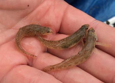
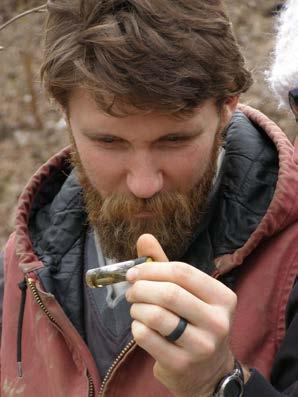
1 Rouge River Watershed 2016 Winter Stonefly Search Ninety-two volunteers participated in Friends of the Rouge s 2016 Winter Stonefly Search on February 13 th on one of the only frigid days of this mild winter. The University of Michigan-Dearborn s Environmental Interpretive Center hosted the event. Participating were four teams from Wayne State University, two teams from Marygrove College, two teams from the 4H Critter Science Investigation Club, one group from Franklin High School and many other volunteers. Stoneflies are sensitive indicators of healthy streams. Unlike other insects, winter stoneflies develop into adult flies in the winter. The Winter Stonefly Search is part of Friends of the Rouge volunteer benthic macroinvertebrate monitoring program. Volunteers were able to sample 26 sites in 13 teams. A total of 38 sites were sampled. Wayne County Department of Public Services Water Quality Management Division sampled an additional six sites, Schoolcraft College students sampled one site and Sue Thompson sampled five sites. Lovebug refreshments! Stoneflies were found at ten of the thirty-eight sites (26%) (see map and Table 1). This was higher than the past two years. Nine sites had slender winter stoneflies (Capniidae) and two sites had Perlodid stoneflies (one site had both). All stoneflies were found on the Middle or Lower branches. Other branches that were sampled included one site on the Main branch and three sites on the Upper branch including Bell Creek. All but three of the ten sites with stoneflies were in the Johnson Creek watershed. Four of these were on Sump Creek, a Johnson Creek tributary in and around Maybury State Park. The highest number of stoneflies at one site was at MR-22 with 22 stoneflies. Both sites with Perlodid stoneflies were on Sump Creek. Two other Johnson Creek sites had stoneflies John1 at Five Mile and Salem Road and John7 in the Arcadia Ridge subdivision. Surprisingly, the Marygrove College team at John1 also found a Rhyacophilid caddisfly, a type of caddisfly first identified in Michigan through Friends of the Rouge s program. Usually found in April, this is the earliest in the year they have been found. On the Lower Rouge, Fellows Creek had one site with stoneflies (LR-9) and Fowler Creek had two sites with them (Fowl1 & Fowl2). Fowl2 has not had stoneflies since Marygrove College students look for stoneflies at Johnson Creek Thank you to all the volunteers! The Winter Stonefly Search is part of Friends of the Rouge s long term volunteer monitoring program. Wayne State University students on the Lower Rouge Spring Bug Hunt Sat. April 16 9am-4 pm UM-D EIC *Register by 4/1* Team Leader Training March 19 (must have previously attended an event) (register online) (313) spetrella@therouge.org Coordinated by Friends of the Rouge and funded by the Alliance of Rouge Communities. Additional data collection by Wayne County and Schoolcraft College
2
3 Table 1: 2016 Stonefly Search Results Branch FIELDID Stream Name Location Collector* ST16 Capnids Perlodids Lower Fel1 Fellows Creek Top of Hill Ct FOTR N Lower Fel2 Fellows Creek Vintage Valley FOTR N Lower Fel4 Fellows Creek Flodin Pk FOTR N Lower Fel5 Fellows Creek Warren Ridge FOTR N Lower Fel6 Fellows Creek Hanford Ridge FOTR N Lower LR-9 Fellows Creek Fellows Beck Warren FOTR Y 1 Lower Fowl1 Fowler Creek Prospect FOTR Y 14 Lower Fowl2 Fowler Creek Fowler Beck FOTR Y 2 Lower Low2 Lower Rouge Cherry Hill FOTR N Lower LR-12 Lower Rouge Morton Taylor WC N Lower LR-3 Lower Rouge Goudy Park WC N Lower LR-8 Lower Rouge Ridge Proctor FOTR N Main MN-5 Main Rouge Bridge St WC N Middle John1 Johnson Creek 5M Salem FOTR Y 10 Middle John2 Johnson Creek 5M NV FOTR N Middle John3 Johnson Creek 6M NV FOTR N Middle John5 Johnson Creek Fish Hatchery Pk FOTR N Middle John6 Johnson Creek Hines FOTR N Middle John7 Johnson Creek Arcadia FOTR Y 3 Middle John8 Johnson Creek Maybury Angell FOTR Y 3 Middle MR-22 Johnson Creek Maybury south ST Y 22 Middle MR-23 Johnson Creek Maybury north ST Y 5 1 Middle MR-25 Johnson Creek Maybury East ST Y 8 Middle MR-26 Johnson Creek Napier Rd ST N Middle MR-27 Johnson Creek Ridge ST Y 2 Middle Mid1 Middle Rouge Northville Rec E FOTR N Middle MR-1 Middle Rouge Northville Rec W FOTR N Middle MR-18 Middle Rouge Springbrook Rec FOTR N Middle MR-2 Middle Rouge Reservoir Rd WC N Middle MR-20 Middle Rouge Waterford Bd FOTR N Middle MR-2a Middle Rouge Reservoir Rd W FOTR N Middle MR-3 Middle Rouge Plym Riverside WC N Middle Ton1 Tonquish Creek Plym Twp Pk FOTR N Middle Ton1/2 Tonquish Creek Canton Ctr Rd FOTR N Upper Bell2 Bell Branch Schoolcraft College Sch N Upper Up1 Upper Rouge Heritage Park FOTR N Upper Up2 Upper Rouge Shiawasee Park FOTR N Upper UR-1 Upper Rouge Lola Valley WC N C*Collector - FOTR=Stonefly Search team, ST=Sue Thompson, WC=Wayne County
4 Rouge River Watershed 2017 Winter Stonefly Search Eighty-two volunteers participated in Friends of the Rouge s 2017 Winter Stonefly Search on January 21 on an unusually warm winter day where the temperatures reached 57 degrees. The University of Michigan-Dearborn s Environmental Interpretive Center hosted the event. Participating were three teams from Wayne State University, a group from Marygrove College, two new teams from Fordson High School, and one new team from Boy Scout Pack 854 and many other volunteers. Stoneflies are sensitive indicators of healthy streams. Unlike other insects, winter stoneflies develop into adult flies in the winter. The Winter Stonefly Search is part of Friends of the Rouge volunteer benthic macroinvertebrate monitoring program. A total of 31 sites were sampled. On January 21, ten teams sampled 20 sites. An additional five sites were sampled by Wayne County Department of Public Services Water Quality Management Division, one site on Bell Creek by Schoolcraft College students, and five sites on Johnson and Tonquish Creeks by Sue Thompson. Stoneflies were found at eighteen of the thirty-one sites (58%) (map and Table 1). Four different types of stoneflies were found: Capnids, Perlodids, Nemourids and Taeniopteryx with the majority being Capnids. All stoneflies were found on the Middle or Lower branches. Eight sites on the Lower Branch had stoneflies. This included four sites on Fellows Creek, three sites on Fowler Creek and one site on the main Lower Branch. All eight sites had slender winter stoneflies (Capnids) and one site (Fel6) also had Perlodids. The highest number of stoneflies on the Lower was at Fowl1 where 45 were found. Nine sites on the Middle branch had stoneflies including one site on the main Middle branch (MR-2a). All nine sites had slender winter stoneflies (Capnids). In addition, one site also had Perlodids (John8), one site had Nemourids (John2) and two sites had Taeniopteryx (John1 and John3). The highest number of stoneflies was found at MR-27 (56). For the first time since 2009, stoneflies were found in the Tonquish Creek. They were found at Ton1. This was an unusual Stonefly Search. In past years, we have been unable to sample some of our small streams because they have been frozen all the way to the bottom. This year, temperatures were so mild that there was no ice at all. But, the thaw did pose a problem in that water levels at some of our sites were too high to safely sample. Rather than postpone the event, we selected only small stream sites. This, along with better access to iceless streams contributed to finding more stoneflies than usual. Thank you to all the volunteers, Team Leaders, Daisy Lovain for running registration, the University of Michigan-Dearborn for providing meeting space, Esma Tuncay for identifying specimens, the Alliance of Rouge Communities for funding, and Schoolcraft College, Wayne County and Susan Thompson for additional sampling. Thank you to those who shared their photos. There were so many good ones we are including as many as we can (see next two page). The Winter Stonefly Search is part of Friends of the Rouge s long term volunteer monitoring program.


5


6 Spring Bug Hunt Sat. April 22 9am-4 pm UM-D EIC *Register by 4/7* Team Leader Training April 1 (must have previously attended an event) (register online) (313) spetrella@therouge.org Coordinated by Friends of the Rouge and funded by the Alliance of Rouge Communities. Additional data collection by Wayne County and Schoolcraft College
7
8 Table 1: 2017 Stonefly Search Results Branch FIELDID Stream Name Location Collector* ST17 Capnids Perlodids Nemourids Taeniopteryx Lower Fel5 Fellows Creek Warren Ridge FOTR Y 6 Lower Fel1 Fellows Creek Top of Hill Ct FOTR N Lower Fel6 Fellows Creek Hanford FOTR Y 3 3 Lower Fel2 Fellows Creek Vintage Valley FOTR N Lower LR-9 Fellows Creek Beck Warren FOTR Y 5 Lower Fel7 Fellows Creek Napier Court FOTR Y 15 Lower Fowl1 Fowler Creek Prospect FOTR Y 45 Lower Fowl3 Fowler Creek Harris FOTR Y 1 Lower Fowl5 Fowler Creek Fowler Denton FOTR Y 5 Lower Nfowl Fowler Creek Fowler Ridge FOTR N Lower LR-8 Lower Rouge Ridge Proctor FOTR Y 20 Lower Low2 Lower Rouge Cherry Hill FOTR N Main MN-5 Main Rouge Bridge St WC N Middle John1 Johnson Creek 5M Salem FOTR Y 5 1 Middle John2 Johnson Creek 5M NV FOTR Y 3 1 Middle John8 Johnson Creek Maybury Angell FOTR Y 4 2 Middle MR-27 Johnson Creek Ridge FOTR Y 56 Middle John3 Johnson Creek 6M NV FOTR Y 18 1 Middle John7 Johnson Creek Arcadia FOTR Y 11 Middle MR-22 Johnson Creek Maybury south ST Y 50 Middle MR-25 Johnson Creek Maybury East ST Y 14 Middle MR-23 Johnson Creek Maybury north ST N Middle MR-26 Johnson Creek Napier Rd ST N Middle MR-3 Middle Rouge Plym Riverside WC N Middle MR-1 Middle Rouge Northville Rec W WC N Middle MR-18 Middle Rouge Springbrook Rec WC N Middle MR-2a Middle Rouge Reservoir Rd W WC Y 4 Middle Ton1 Tonquish Creek Plym Twp Pk FOTR Y 2 Middle Ton1/2 Tonquish Creek Canton Ctr Rd FOTR N Middle MR-28 Tonquish Creek N Branch ST N Upper Bell2 Bell Branch Schoolcraft College Sch N * FOTR=Stonefly Search team, Sch=Schoolcraft College, ST=Sue Thompson, WC=Wayne County
 792-9621 Rouge River Benthic Monitoring Program Spring 2016 Report This report covers benthic macroinvertebrate monitoring at 53 sites on Rouge River tributaries and")
9 Evergreen Rd., KM Dearborn, MI (313) Rouge River Benthic Monitoring Program Spring 2016 Report This report covers benthic macroinvertebrate monitoring at 53 sites on Rouge River tributaries and branches in the spring of Thirty-two sites were sampled by Friends of the Rouge (FOTR) volunteers and staff, fifteen were sampled by Wayne County Department of Public Services Water Quality Management Division, three were sampled by Susan Thompson, one was sampled by Schoolcraft College students and two were sampled by Wayne State University s Ecology Class. FRIENDS OF THE ROUGE BENTHIC MONITORING PROGRAM FOTR s benthic monitoring program was started in 2001 to involve a large number of volunteers in monitoring the health of the watershed by sampling the creeks of the Rouge River. The types and number of benthic macroinvertebrates found can be used to assess water quality. Each team of volunteers samples two sites under the direction of a trained team leader. Samples of each organism are collected and field identifications are verified in the lab. The program is funded by the Alliance of Rouge Communities and in cooperation with Wayne County Department of Public Services Water Quality Management Division. Most of Friends of the Rouge s sites were sampled on April 16 during the Spring Bug Hunt in which 102 people participated. Groups participating in the event were Cub Scout Pack 247 (6 groups), Wayne State University (3 groups), Marygrove College, and the Antea Group. Overall Scores The majority of sites (30/53 or 57%) had FAIR Stream Quality Index scores (SQI) with an average score of 29 (Table 3). Three sites rated EXCELLENT and 12 rated GOOD. Eight sites had POOR SQI. The number of taxa at each site ranged from a low of five at three Upper branch sites (Bell1, Tar2, Up2) to a high of 26 at one Johnson Creek site (John2). The number of EPT (see sidebar) ranged from zero to seven. The seven were at one Johnson Creek site (MR-27) and one Middle Rouge site (MR-20). Seven sensitive families were found at eight sites (see Table 4) including three stonefly families, one mayfly family, one caddisfly family, dobsonflies and gomphid (clubtail) dragonfly nymphs. Stream Quality Index, Taxa, EPT and Sensitive Families Each site is given a Stream Quality Index (SQI) which is determined by weighting each type and number of organisms found by their sensitivity ratings. A higher proportion of sensitive organisms such as mayflies and caddisflies results in a higher score. A number of different organisms also results in a high score. The SQI is then given a rating: >48 = EXCELLENT = GOOD = FAIR <19 = POOR Number of taxa represents the number of different families of organisms. A higher number of taxa indicate a healthier site. EPT refers to the number of mayfly, caddisfly and stonefly families found; these three orders contain some of the most sensitive organisms. Sensitive Families refers to insects that are rated 1 on the Hilsenhoff Sensitivity Index. Trend Analysis To determine whether the Rouge River is improving over time, SQI scores are averaged for each subwatershed and Johnson Creek (a cold water tributary) and the slope is plotted. A positive slope indicates an upward trend (scores increasing); a negative slope indicates a downward trend (scores decreasing). The trend is significant if the p-value is less than Data Trends Table 1 contains the data trends by subwatershed/creek. The Johnson Creek, the Middle 1 and the Middle 3 subwatershed are showing significant positive trends. No other subwatersheds had significant trends. 1

10 Table 1 - FOTR and WC Spring Bug Hunt Summary Branch slope p-value True trend Subwatershed average score Water Quality Rating Main no trend 27 Fair Main3-4* NA NA NA 25 Fair Upper no trend 24 Fair Johnson Creek yes, positive 39 Good Middle yes, positive 29 Fair Middle yes, positive 20 Fair Lower no trend 30 Fair Lower no trend 26 Fair *no sites sampled spring 2016 In addition to the trend analysis by subwatershed, a site-by-site analysis of all the sites was done (Table 2). The majority of the sites had no trend. Two sites had a statistically significant positive trend: John2 and Ton2. John2 is a Johnson Creek site that normally scores very high. Ton2 is a Tonquish Creek site impacted by urban development that suffers from poor macroinvertebrate diversity. One site had a statistically significant negative trend: Peb3. This site is located on Pebble Creek downstream of a recent dam removal. Table 2 - FOTR & WC Spring Bug Hunt Significant Trends by site Site p-value Slope True trend Site average score Water Quality Rating Peb yes, negative 27 Fair John yes, positive 46 Good Ton yes, positive 19 Fair Lower Branch Standard Deviation Thirteen sites were sampled on the Lower Branch of the Rouge (see Table 3). McClaugherty Creek was sampled at one location (LR-7), Fellows Creek was sampled at three locations (Fel1, Fel2 LR-5) and Fowler Creek at one (Fowl2). On the main branch of the Lower, eight sites were sampled. While sampling Fel2, a team of WSU students were alarmed by a large amount of construction material dumped along the stream including concrete poured down the bank (see photo below). FOTR contacted Canton Township who sent out an inspector to meet with the homeowner and tell them to clean it up. This is a great example of how this program helps to unearth problems and get them addressed. The Lower subwatershed did not have a significant trend and most sites scored FAIR (average 26). Three Some sites have consistent scores where others vary greatly year to year. Standard deviation is a measure of how spread out your data is. 68% of your data will fall within one standard deviation of the mean (red areas shown above). On Charts 1-4, one standard deviation is represented by the vertical lines for each site. Standard deviation helps us to determine whether the current score is within normal for the site. sites had GOOD scores (Fel2, LR-6 and Low3), all the rest scored FAIR. The number of taxa ranged from 8-16 and EPT: 0-3. One sensitive family was found: free-living (Rhyacophilidae) caddisflies at LR-8. This is the first time this species was found at LR-8 though it has been found upstream at Low2. Eleven sites had past data for three years or more (Chart 1). Three sites were above a standard deviation of average (Fel2, LR-6 and LR-10) and two sites below (LR-8 and LR-12). No sites showed any trend when analyzed by site. 2
, Franklin (Frank1, Frank2), Pebble (Peb1, Peb3), Sprague (Sprag) and Quarton Creeks (Main11). The Main1/2 subwatershed is not showing any trend (Table 1).")
11 Chart 1: Lower Branch SQI and Mean with Standard Deviation Main Branch Ten sites on the Main Branch were sampled. Seven were on tributaries: Evans (Evan2), Franklin (Frank1, Frank2), Pebble (Peb1, Peb3), Sprague (Sprag) and Quarton Creeks (Main11). The Main1/2 subwatershed is not showing any trend (Table 1). The majority (8) of the scores were FAIR (average 25). There were two GOOD SQIs (MN-5, Sprag), three were POOR (Frank2, Peb1, Peb3). The number of taxa ranged from 6-19 and EPT 1-4. Sensitive clubtail dragonfly larvae (Gomphidae) and dobsonflies (Corydalidae) were found in Sprague Creek in Troy (Sprag). Large native mussels including these white heelsplitters (Lasmigona complanata) were found at Firefighters Park in Troy (Main1). FOTR has identified four species of native mussels at this site and the Main branch has the highest diversity of native mussels in the watershed. There are only 11 species still found live in the Rouge River system. For the seven sites with three years or more of past data (Chart 2), three sites were below a standard deviation of the mean (Peb1, Peb3 and Frank2). Peb3 also had a negative trend when analyzed by site (Table 2) Chart 2: Main Branch & Tributary SQI and Mean with Standard Deviation 3
. The team that sampled John3 found a 15 inch brown trout (see photo below), part of a population once stocked by the Department of Natural Resources.")
12 Middle Branch Twenty sites were sampled on the Middle branch including four tributaries: Bishop (Bish2), Ingersoll (Ing1), Johnson (John2, MR-23, MR-26, John6, MR-22, MR-25, MR-27, John3) and Tonquish Creeks (Nton, Ton2, MR-16, Ton1). The team that sampled John3 found a 15 inch brown trout (see photo below), part of a population once stocked by the Department of Natural Resources. Stocking was discontinued when surveys revealed a decline in the number of redside dace(an endangered minnow) in areas where large numbers of these non-native fish were found. Average scores for the Johnson Creek, the Middle1 and the Middle3 subwatersheds are all showing positive trends (Table 1). The average score was GOOD (35) and the Middle Branch had three EXCELLENT SQIs (John2, MR-27, MR-20). The score for MR-20 was unusually high at 52. There were no POOR scores, 7 GOOD and ten FAIR. The number of taxa ranged from 9-26 and EPT 1-7. Sensitive families were found in most of the Johnson Creek sites. Sensitive families included slender winter (Capniidae) stoneflies (MR-22) Perlodid stoneflies (John2, MR-25 and MR-27), Perlid stoneflies (MR-20 and John2, pronggill (Leptophlebiidae) mayflies (John3, MR-22, MR-25 and MR-27). For the seventeen sites with past data (Chart 3 and 4), three site SQIs were above a standard deviation (John2, Bish2 and MR- 16) and two site SQIs were below (John3, MR-23). When analyzed site by site, two sites showed a trend and both were positive: John2 and Ton2 (Table 2). Chart 3: Middle Branch Tributary SQI and Mean with Standard Deviation 4
13 Chart 4: Middle Branch SQI and Mean with Standard Deviation Upper Branch Ten Upper branch sites were sampled this spring, including five tributaries: Beitz (UR-5), Bell (Bell1, Bell2, Bell3), Minnow Pond (Min1, Min3), Seeley (See2, See3) and Tarabusi Creeks (Tar2). The Upper Subwatershed did not show any overall trend (Table1). The average score was POOR (19). Five sites scored POOR (Bell1, Bell2, Bell3, Tar2, Up2). All the rest of the sites scored FAIR. There were no GOOD or EXCELLENT scores. The number of taxa ranged from 5-11 and EPT 1-3. There were no sensitive families found. Minnow Pond and Seeley Creek had the highest scores for the Upper subwatershed. An American toad came by to check on the action at Min3. For the nine sites with past data (Chart 5), four sites were below a standard deviation of the mean (Bell1, Bell2, Tar2, Up2). In the trend analysis for sites, no Upper sites showed any trend. Chart 5: Upper Branch SQI with Mean and Standard Deviation 5
14 6
15 Table 3: Stream Quality Index, score, taxa, EPT (mayfly, stonefly and caddisfly families) and sensitive families found Branch FIELDID Stream Name Site Name Location Latitude Longitude SQI Score Taxa EPT Sens Collector sensitive families Lower LR-7 McClaugherty Creek McClaugherty Ecorse & Hannan FAIR WC Lower LR-5 Fellows Creek Fellows Lotz Finley Dr Finley Drive FAIR FOTR Lower Fel1 Fellows Creek Top of Hill Ct Napier/Powell FAIR FOTR Lower Fel2 Fellows Creek Vintage Valley Ford/Ridge GOOD FOTR Lower Fowl2 Fowler Creek Fowler Beck Beck, N of Geddes FAIR FOTR Lower LR-11 Lower Rouge Ford Field Brady & Cherry Hill FAIR WC Lower LR-11A Lower Rouge Ford Field east east of Ford Field FAIR WC Lower LR-8 Lower Rouge Ridge Proctor Ridge & Proctor FAIR FOTR Rhyacophilidae Lower LR-2 Lower Rouge WTUA Geddes/Beck FAIR WC Lower LR-12 Lower Rouge Morton Taylor east of Morton Taylor FAIR WC Lower LR-10 Lower Rouge Inkster John Daly north of Michigan FAIR WC Lower LR-6 Lower Rouge Wayne WDM Wayne Rd W GOOD WC Lower Low3 Lower Rouge Gotfredson GOOD FOTR Main Evan2 Evans Creek LTU 10 Mile/Northwestern FAIR FOTR Main Frank2 Franklin Creek Ink Pump Sta Inkster & Farmington POOR FOTR Main Frank1 Franklin Creek Franklin Cider Mill 14 Mile/Franklin Rd FAIR FOTR Main Main1 Main Rouge FF Pk Coolidge/I FAIR FOTR Main Main6 Main Rouge Sfld Civic Ctr Civic Center Dr/Telegraph FAIR FOTR Main MN-5 Main Rouge Bridge St Bridge w of Telegraph GOOD WC Main Peb1 Pebble Creek Danvers Ct Danvers Ct POOR FOTR Main Peb3 Pebble Creek Pebble d/s Dam Danvers Drive POOR FOTR Main Main11 Quarton Branch Quarton at Lakeside Lakeside/Midland Dr FAIR FOTR Main Sprag Sprague Creek Main Lloyd Stage 6685 Coolidge GOOD FOTR Corydalidae, Gomphidae Middle Bish2 Bishop Creek Bishop Scarborough 10 Mile/Meadowbrook FAIR FOTR Middle Ing1 Ingersoll Creek Brookfarm Park Willowbrook/10 Mile FAIR FOTR Middle John3 Johnson Creek 6M NV 6 Mile/Beck FAIR FOTR Leptophlebiidae Middle MR-23 Johnson Creek Maybury north 8 Mile FAIR WSU Middle MR-26 Johnson Creek Napier Rd 8 Mile/Napier GOOD ST Middle John6 Johnson Creek Hines Hines/Sheldon GOOD FOTR Middle MR-22 Johnson Creek Maybury south 7 Mile N & Napier GOOD ST Leptophlebiidae, Capniidae Middle MR-25 Johnson Creek Maybury East Beck/Main St GOOD WSU Leptophlebidae, Perlodidae Middle MR-27 Johnson Creek Ridge Ridge S of 7 Mile EXCELLENT ST Leptophlebiidae, Perlodidae Middle John2 Johnson Creek 5M NV 5 Mile/Ridge EXCELLENT FOTR Perlidae, Perlodidae Middle MR-8 Middle Rouge Inkster Rd W of Inkster, S of Hines FAIR WC Middle Mid5 Middle Rouge Helms Haven Hines/Outer Dr FAIR FOTR Middle MR-9 Middle Rouge Wallaceville E of Beech Daly FAIR WC Middle MR-3 Middle Rouge Plym Riverside S of Plymouth GOOD WC Middle MR-1 Middle Rouge Northville Rec W Hines/7 Mile GOOD WC Middle MR-20 Middle Rouge Waterford Bd Waterford Bend EXCELLENT WC Perlidae Middle Nton Tonquish Creek S Evergreen St Harvey & Penniman FAIR FOTR Middle Ton2 Tonquish Creek Ann Arbor Rd Ann Arbor Rd/Lilley FAIR FOTR Middle MR-16 Tonquish Creek Canoe Pk W of Ann Arbor Trail/Hines FAIR WC Middle Ton1 Tonquish Creek Plym Twp Pk Beck/Ann Arbor Tr GOOD FOTR Upper UR-5 Beitz Creek Beitz Creek/6 Mile 6 Mile west of Farmington Rd FAIR WC Upper Bell1 Bell Branch Bicentennial Park 7 Mile/Newburgh Rd POOR FOTR Upper Bell3 Bell Branch Livonia 6 Mile 6 Mile/Farmington POOR FOTR Upper Bell2 Bell Branch Schoolcraft College 6 Mile/Haggerty POOR Sch Upper Min3 Minnow Pond Dunckel 12 Mile/OL FAIR FOTR Upper Min1 Minnow Pond Minnow 13 M 13 Mile/Farmington FAIR FOTR Upper See2 Seeley Creek Sleepy Hollow Drake/11 Mile FAIR FOTR Upper See3 Seeley Creek Kennedy Ct Kennedy Court FAIR FOTR Upper Tar2 Tarabusi Creek Tara 8 M 8 Mile/Gill POOR FOTR Upper Up2 Upper Rouge Shiawasee Park Shiawassee/Power POOR FOTR Thank you to all the volunteers and Team Leaders, Wayne County for sampling and providing data for fifteen sites and doing the trend analysis, Bruce McCulloch for graphing data and advising us, University of Michigan-Dearborn for providing the meeting place for the Spring Bug Hunt and a lab for identification night, Sue Thompson for sampling additional sites, Wayne State University students for sampling two sites and Diane O Connell and Schoolcraft College students for sampling one site. Fall Bug Hunt - Oct. 15, am-4pm Schoolcraft College VisTaTech Center Sign up online today (deadline Sept. 30, 2016 at Team Leader Training Sat. Oct. 1, am-2pm (must have participated in a previous event) 7
 792-9621 Rouge River Benthic Macroinvertebrate Monitoring Program Fall 2016 Report This report contains benthic macroinvertebrate sampling results")
.")

16 Evergreen Road, KM Dearborn, MI (313) Rouge River Benthic Macroinvertebrate Monitoring Program Fall 2016 Report This report contains benthic macroinvertebrate sampling results from 44 Rouge tributary and river sites. The Fall Bug Hunt on October 15 had 89 participants. There were 13 teams that sampled 25 sites. Groups participating included five teams from Wayne State University and one CSI Team (Critter Science Investigation). The Schoolcraft College Geography Department once again provided the meeting space and refreshments and volunteer Daisy Lovain ran the registration. This report also includes data from additional FOTR sampling, one site sampled by Schoolcraft College students, three sites sampled by Sue Thompson and 14 sites sampled by Wayne County DPS. New Dragonfly Species Found Royal River Cruiser Nymph photo credit: Nancy Gregor Wayne County DPS Sue Thompson discovered a new dragonfly family and species for the watershed at two Middle Rouge sites above and below Newburgh Lake (MR-4 and MR-3). Its large size, long spidery legs and frontal horn led her to identify it in the Macromiidae family. Macromiidae naiads live in the muck and debris near the substrate surface in slow areas of streams where they wait to ambush prey (Hilsenhoff, 1995). The adult dragonflies cruise down the middle of streams and roads, thus the common family name Cruisers. Because this was the first finding of this family in the Rouge River, the specimens from both sites were sent out for further identification. A late instar nymph from MR-4 was identified by Ethan Bright and Darrin O Brien as a Royal River Cruiser, Macromia taeniolata. According to Julie Craves, co-author of the Michigan Odonata Atlas, this species was not recorded in Wayne County until 2001, and despite extensive work in the watershed, was not found in the Rouge during fieldwork from (Craves and O Brien 2013, An earlier instar nymph collected at MR-3 is also in the Macromiidae family, and most likely the same species. Only three other members of this family have been found in Michigan. Stream Cruiser (Didymops transversa) and Swift River Cruiser (Macromia illinoiensis) are both fairly common and widespread, while M. taeniolata is much rarer and has only been documented in the southern Lower Peninsula. Alleghany River Cruiser (M. alleghaniensis) has only been recorded once in the state. Adult Royal River Cruiser, Huron River, Wayne County photo credit: Darrin O Brien 1

, Bruce McCulloch, Diane O Connell, Steve Weis Additionally, nine volunteers who have participated for five years or more")
17 Thank you to our long-term Volunteers! The benthic macroinvertebrate monitoring program would not be possible without volunteers who are willing to come back year after year, going through training and taking on leadership roles. At the Fall Bug Hunt, we recognized six volunteers who have participated for ten years or more (see photo at left). Volunteers were recognized with certificates and special pins. From left: Chester Marvin, Susan Thompson, Ralph Williams (Sally Petrella), Bruce McCulloch, Diane O Connell, Steve Weis Additionally, nine volunteers who have participated for five years or more were recognized with certificates. Thank you to the Michigan Clean Water Corps for providing certificates and pins. From left: Stuart Steel, Lynn DeGrande, Lisa Agosta, Grant Faber, Daisy Lovain, (Sally Petrella), Dan Stowe, Alan Vankerckhove, Sandy & Doug Wallace Overall Scores Of the 44 sites sampled this fall, the average Stream Quality Index (SQI) was FAIR (28) (map p.6, Table 1 & 4). Sites averaged 12 taxa, two mayfly, stonefly and/or caddisfly families (EPT) and zero sensitive Families. One site had an EXCELLENT SQI: Sprag. Twelve sites were GOOD; 21 sites were FAIR and ten sites scored POOR. The number of taxa found at sites was highest at MR-20 and MR- 27 (20) and lowest at Low3 and See 2(5). Table 1: Averages Average SQI Average # of taxa Average # EPT Average # Sensitive Families Some mayfly, stonefly and caddis fly families (EPT) were found at all but five sites. Three Johnson Creek sites and Sprag had the highest number of these families (4 at MR-3, MR-20, MR-27 & Main1). Understanding Benthic Scores Each site is given a Stream Quality Index (SQI) which is determined by weighting each type and number of organisms found by their sensitivity ratings. A higher proportion of sensitive organisms such as mayflies and caddisflies results in a higher SQI. A greater number of different organisms also results in a high SQI. The SQI has four different levels: >48=EXCELLENT, 34-48=GOOD, 19-33=FAIR, <19=POOR. Number of taxa represents the number of different families of organisms. Like SQI, a higher number of taxa indicate a healthier site. Number of insect taxa insects are more sensitive than the non-insect taxa. EPT refers to the number of mayfly, caddisfly and stonefly families found; these three orders contain some of the most sensitive organisms. Number of sensitive families refers to the number of families of insects that rate very sensitive on the Hilsenfhoff Biotic Index. 2
.")
18 Four sites had sensitive families and all had been found at the sites in the past. MR-1 had net-tube caddisflies (Psychomyiidae). MR-27 had prongill mayflies (Leptophlebiidae). MN-5 and Sprag had dobsonflies (Corydalidae). Data Trends Chart 1: Trends for sites with past Data For the forty-four sites that had three or more years of past data, 70% were stable, 11% were improving and 18% were declining (Chart 1). Compared to last fall, a lower percentage of sites are declining, more sites are improving and more are stable. To compare change over time, we analyzed the trends (Table 2 and Figures 1-8). The Middle 3 subwatershed and Johnson Creek had significant positive slopes and both the Main 1-2 and the Upper Branch had significant negative slopes. Individual sites were examined for long term trends (Table 3). Of the sites with sufficient data sampled in Fall 2016, three had significant trends. All three showed a declining trend. Table 3: Fall Bug Hunt Trend Summary by site Site slope p -value True trend Mean SQI score Peb yes, negative 27 Fair Main yes, negative 20 Fair Ing yes, negative 29 Fair Table 2: Fall Bug Hunt trend summary All Sites Subwatershed slope p -value True trend Mean SQI score Main yes, negative 30 Fair Upper yes, negative 25 Fair Johnson Creek yes, positive 35 Good Middle No trend 32 Fair Middle yes, positive 22 Fair Lower no trend 29 Fair Lower no trend 27 Fair Main no trend 28 Fair Lower Branch Seven sites were sampled on the Lower Branch of the Rouge (see Table 3). Two tributaries were sampled: Fellows (2) and McClaugherty. An additional four sites on the main branch of the Lower were sampled. Chart 2: Lower Branch Fall 2015 SQIs and means SQIs averaged FAIR (27). Two sites scored GOOD, three FAIR and two POOR. No sensitive families were found at any of the sites. Seven sites had three or more years of data (Chart 2). Two sites were above a standard deviation of the average for the site (Fel2 and LR-1) and one was below (Low2). Long term trend analysis showed no significant change in the scores for the Lower Branch since No individual sites showed a significant trend. 3
19 Main Branch Chart 3: Main Branch Tributary Fall 2015 SQIs and means Fourteen sites on the Main Branch were sampled. This included six tributaries: Evans, Franklin, Murphy, Nottingham, Pebble (2) and Sprague and seven sites on the Main. SQIs averaged FAIR (28). There was one EXCELLENT, two GOOD, seven FAIR, and four POOR SQIs. The EXCELLENT site was Sprag at the Stage Nature Center in Troy. GOOD sites were MN-2 and MN-5. Sensitive dobsonflies (Corydalidae) were found at both MN-5 and Sprag. Thirteen sites on the Main had three or more years of data (Charts 3 & 4). Three sites (Sprag, Main1 and MN- 2) were above a standard deviation of the mean and three were below (Mur2, Peb3, Main8). Chart 4: Main Branch Fall 2015 SQIs and means Long term trend analysis shows a significant negative trend for the Main 1/2 subwatershed (Table 2, Figures 1-8). Two Main Branch sites also showed a decline (Peb3 and Main8). Middle Branch Fifteen sites were sampled on the Middle Branch including Ingersoll, Johnson (5), Tonquish (2) and the Walled Lake drainage (Table 3). SQI scores averaged a high FAIR (32). There were 8 GOOD, 5 FAIR and one POOR (MR-8) SQIs. Sensitive families were found at MR-27 (Leptophlebiidae) & MR-1(Psychomyiidae). Chart 5: Middle Branch Tributaries SQIs and means Fourteen sites had three years or more of data (Charts 5 & 6). Of these, one was above a standard deviation of the mean (MR-13) and two were below (Wall1, MR- 8). In long term trend analysis, the Middle 3 and Johnson Creek had positive trends (Table 2, Figures 1-8). One Middle Branch site showed a negative trend (Ing1 see Table 3) 4
20 Chart 6: Middle Branch SQIs and means Upper Branch Chart 7: Upper Branch SQIs and means Eight Upper branch sites were sampled this fall, including the Bell (2), Beitz and Seeley(2) (Table 3). SQIs averaged a low FAIR (22). Six sites were FAIR and two POOR (See2 & See3). No sensitive families were found in the Upper Branch. Seven sites had three years or more of data (Chart 7). Two sites were below a standard deviation of the norm (See3 & UR-2). Long term trend analysis shows a significant decline in scores since No individual sites had significant trends. THANK YOU!!!!! Thank you to all the volunteers and Team Leaders, Schoolcraft College for hosting the event, professor Diane O Connell and the Geography Department for providing refreshments, Daisy Lovain for running registration, Wayne County for sampling and providing data for 14 sites, Bill Eisenman for assisting with Fordson Island sampling, Sue Thompson for sampling additional sites, helping with identification, trend analysis and reviewing the report, biologist Bruce McCulloch for identifying most of the specimens, SQI comparison graphs and reviewing the report, Julie Craves, Darrin O Brien and Ethan Bright for identifying and info on the Royal River Cruiser and the Alliance of Rouge Communities for funding the program through a SAW Grant. Join us for the Winter Stonefly Search Sat. Jan. 21, am 3 pm at UM-D Register at (by Jan. 6, 2017) 5

21 6
22 Table Fall Bug Hunt Results FIELDID Stream Name Site Description collector SQI score taxa EPT Sensitive Family Lower Branch Fel1 Fellows Creek Top of Hill Ct FOTR 26 FAIR 11 1 Fel2 Fellows Creek Vintage Valley FOTR 36 GOOD 16 3 McClaugherty LR-7 Creek Hannan and Ecorse WC 31 FAIR 14 1 Low2 Lower Rouge Cherry Hill FOTR 15 POOR 7 0 Low3 Lower Rouge Gotfredson FOTR 15 POOR 5 1 LR-1 Lower Rouge Commerce Ct WC 37 GOOD 16 3 LR-11A Lower Rouge Ford Field east WC 28 FAIR 13 2 Main Branch Evan2 Evans Creek LTU FOTR 16 POOR 8 1 Frank2 Franklin Creek Ink Pump Sta FOTR 12 POOR 6 0 Mur2 Murphy Creek Roeper School FOTR 16 POOR 7 1 Nott Nottingham Creek Country Day FOTR 27 FAIR 9 2 Peb2 Pebble Creek Pebble 13 Mile FOTR 25 FAIR 11 1 Peb3 Pebble Creek Pebble d/s Dam FOTR 20 FAIR 8 1 Sprag Sprague Creek Main Lloyd Stage FOTR 53 EXCELLENT 18 3 Corydalidae Main1 Main Rouge FF Pk FOTR 33 FAIR 17 4 Main3 Main Rouge Booth Pk FOTR 25 FAIR 11 3 Main4 Main Rouge Linden Pk FOTR 32 FAIR 13 3 Main6 Main Rouge Sfld Civic Ctr FOTR 31 FAIR 15 3 MN-2 Main Rouge Eliza Howell WC 38 GOOD 16 3 MN-5 Main Rouge Bridge St WC 41 GOOD 17 3 Corydalidae Main8 Main Rouge Fordson Island FOTR 16 POOR 8 0 Middle Branch Ing1 Ingersoll Creek Brookfarm Park FOTR 21 FAIR 10 0 John3 Johnson Creek 6M NV FOTR 34 GOOD 15 2 John6 Johnson Creek Hines FOTR 39 GOOD 15 3 MR-22 Johnson Creek Maybury south ST 34 GOOD 17 2 MR-26 Johnson Creek Napier Rd ST 37 GOOD 17 2 MR-27 Johnson Creek Ridge ST 44 GOOD 20 4 Leptophlebiidae Ton1/2 Tonquish Creek Canton Ctr Rd FOTR 33 FAIR 10 3 Ton2 Tonquish Creek Ann Arbor Rd FOTR 20 FAIR 8 1 Wall1 Walled Lk Drainage Rotary Pk FOTR 14 POOR 7 1 MR-1 Middle Rouge Northville Rec W WC 37 GOOD 16 2 Psychomyiidae MR-20 Middle Rouge Waterford Bd WC 48 GOOD 20 4 MR-3 Middle Rouge Plym Riverside WC 43 GOOD 18 4 MR-4 Middle Rouge Levan Knoll WC 28 FAIR 12 2 MR-8 Middle Rouge Inkster Rd WC 15 POOR 7 1 MR-13 Middle Rouge Warrendale WC 28 FAIR 10 2 Upper Branch Bell2 Bell Branch Schoolcraft College SC 24 FAIR 11 1 See2 Seeley Creek Sleepy Hollow FOTR 17 POOR 5 2 See3 Seeley Creek Kennedy Ct FOTR 15 POOR 7 1 Up1 Upper Rouge Heritage Park FOTR 21 FAIR 11 0 Up2 Upper Rouge Shiawasee Park FOTR 26 FAIR 13 1 UR-1 Upper Rouge Lola Valley WC 26 FAIR 10 2 UR-2 Bell Branch Bell Cr Pk WC 22 FAIR 8 2 UR-5 Beitz Creek Beitz Creek/6 Mile WC 32 FAIR
23 Figure 1- Lower1 Subwatershed Mean SQIs Figure 2- Lower2 Subwatershed Mean SQIs Figure 3- Main 1/2 Subwatershed Mean SQIs Figure 4- Main 3/4Subwatershed Mean SQIs 8
24 Figure 5 Johnson Creek Mean SQIs Figure 6 Middle 1 Subwatershed Mean SQIs Figure 7 Middle 3 Subwatershed Mean SQIs Figure 8 Upper Subwatershed Mean SQIs 9
 792-9621 Rouge River Benthic Monitoring Program Spring 2017 Report This report covers benthic macroinvertebrate monitoring at 48 sites on Rouge River tributaries and")
25 Evergreen Rd., KM Dearborn, MI (313) Rouge River Benthic Monitoring Program Spring 2017 Report This report covers benthic macroinvertebrate monitoring at 48 sites on Rouge River tributaries and branches in the spring of Twenty-six sites were sampled by Friends of the Rouge (FOTR) volunteers and staff, sixteen were sampled by Wayne County Department of Public Services Water Quality Management Division, three were sampled by Susan Thompson, one was sampled by Schoolcraft College students and two were sampled by Wayne State University s Ecology Class. Most of Friends of the Rouge s sites were sampled on May 6 during the Spring Bug Hunt in which 78 people participated. Groups participating in FRIENDS OF THE ROUGE BENTHIC MONITORING PROGRAM FOTR s benthic monitoring program was started in 2001 to involve a large number of volunteers in monitoring the health of the watershed by sampling the creeks of the Rouge River. The types and number of benthic macroinvertebrates found can be used to assess water quality. Each team of volunteers samples two sites under the direction of a trained team leader. Samples of each organism are collected and field identifications are verified in the lab. The program is funded by the Alliance of Rouge Communities and in cooperation with Wayne County Department of Public Services Water Quality Management Division. the event were Scout Pack 247, Wayne State University and Marygrove College. The event had been rescheduled from the original April 22 date due to high water but water levels were high again on May 6. Stream Quality Index, Taxa, EPT and Sensitive Families Each site is given a Stream Quality Index (SQI) which is determined by weighting each type and number of organisms found by their sensitivity ratings. A higher proportion of sensitive organisms such as mayflies and caddisflies results in a higher score. A number of different organisms also results in a high score. The SQI is then given a rating: >48 = EXCELLENT = GOOD = FAIR <19 = POOR Number of taxa represents the number of different families of organisms. A higher number of taxa indicate a healthier site. EPT refers to the number of mayfly, caddisfly and stonefly families found; these three orders contain some of the most sensitive organisms. Sensitive Families refers to insects that are rated 1 on the Hilsenhoff Sensitivity Index. Overall Scores Rain prior to sampling days can affect scores as water levels rise rapidly, washing bugs downstream and making it difficult to sample each site completely. Downstream sites cannot be accessed at all when the water becomes too deep to wade. It also becomes difficult to see the bugs when sediment is washed into the streams. With the high water, the list of sites was changed to smaller headwater streams but some sites were still difficult to sample. In analyzing the results, four sites had scores that were significantly different than what would be expected. These are considered outliers and will not be considered in the analysis. The majority of sites (28/44 or 64%) had FAIR Stream Quality Index scores (SQI) with an average score of 32 (Table 3). Fifteen sites rated GOOD and one sites had a POOR score of 14. The number of taxa at each site ranged from a low of seven on the Lower Rouge at Ford Field (LR-11A) to a high of 23 at one Johnson Creek site (MR-27). The number of EPT (see sidebar) ranged from zero to seven. The seven were found at one Johnson Creek site (MR-27). Eleven sites had sensitive families (see Table 4) including two stonefly families, one mayfly family and dobsonflies. A new family of insects was found by biologist Susan Thompson at MR-4: little stout crawler mayflies. Though all mayflies are considered sensitive, this family is adapted to silty conditions like those often found in the Rouge after rain (see below). Spiny crawler mayfly nymph credit: Aquatic Insects of Central Virginia Little Stout Crawler Mayflies by Susan Thompson Family name: Leptohyphidae (Tricorithidae) Little Stout Crawler mayflies have triangular plate-like gill coverings that protect the breathing gills underneath from becoming clogged with silt. This adaptation allows these mayflies to live in silty habitats. The mayfly breathes by lifting the plate-like gills slightly and waving the gills underneath. They live in flowing waters in small to large rivers and prefer areas with slow current as they are not really good swimmers. They are primarily crawlers (like their name) and can be found in a variety of substrate: silt, fine sand, woody debris or on vegetation. They are primarily collector/gatherers, feeding on vegetation. Tricorithidae is one of the mayfly families that is more tolerant, since they can live in silty substrates and slower moving current where less dissolved oxygen is present. (Voshell, 2002) 1

26 Data Trends Table 1 contains the data trends by subwatershed/creek. The Johnson Creek, the Middle 1 and the Middle 3 subwatersheds are showing significant positive trends. No other subwatershed had significant trends. Trend Analysis To determine whether the Rouge River is improving over time, SQI scores are averaged for each subwatershed and Johnson Creek (a cold water tributary) and the slope is plotted. A positive slope indicates an upward trend (scores increasing); a negative slope indicates a downward trend (scores decreasing). The trend is significant if the p-value is less than Table 1 - FOTR and WC Spring Bug Hunt Summary Branch slope p-value True trend Subwatershed average score Water Quality Rating Main no trend 27 Fair Main no trend 25 Fair Upper no trend 24 Fair Johnson Creek yes, positive 39 Good Middle yes, positive 30 Fair Middle yes, positive 20 Fair Lower no trend 30 Fair Lower no trend 26 Fair In addition to the trend analysis by subwatershed, a site-by-site analysis of all the sites was done (Table 2). Only one site had a trend UR-5. Table 2 - FOTR & WC Spring Bug Hunt Significant Trends by site Site p-value Slope True trend Site average score Water Quality Rating UR yes, positive 23 Fair 2
 and Fellows Creek was sampled at five locations (Fel1, Fel2, Fel5, Fel6, LR-9). On the main branch of the Lower, six sites were sampled.")
27 Lower Branch Standard Deviation Twelve sites were sampled on the Lower Branch of the Rouge (see Table 3). McClaugherty Creek was sampled at one location (LR-7) and Fellows Creek was sampled at five locations (Fel1, Fel2, Fel5, Fel6, LR-9). On the main branch of the Lower, six sites were sampled. Some sites have consistent scores where others vary greatly year to year. Standard deviation is a measure of how spread out your data is. 68% of your data will fall within one standard deviation of the mean (red areas shown above). On Charts 1-4, one standard deviation is represented by the vertical lines for each site. Standard deviation helps us to determine whether the current score is within normal for the site. Most of the Lower sites scored FAIR (average 29). Four sites had GOOD scores (Fel5, Low13, LR-8, and LR-7), seven scored FAIR, and one scored POOR (LR-11A). The number of taxa ranged from Two sensitive families were found: Corydalidae (Dobsonflies) at Fel5 and Perlodidae stoneflies at Low2 and LR-8. The Lower1 and Lower 2 subwatersheds did not have significant trends though the slope was positive (Table 1). Eight sites had past data for three years or more (Chart 1). All were within a standard deviation of the mean. No sites showed any trend when analyzed by site (Table 2). Overall, macroinvertebrates in the Lower branch are not showing any improvement but they also are not showing any decline. SQI Chart 1: Lower Branch SQI and Mean with Standard Deviation 55 Excellent Good Fair Poor 5 0 Fel1 Fel2 Low2 LR-4 LR-6 LR-7 LR-8 LR SQI Mean w. SD 3
 were the one sensitive family, found in Sprague Creek in Troy (Sprag).")
28 Main Branch Eight sites on the Main Branch were sampled. Four were on tributaries: Pebble (Peb1, Peb3), Sprague (Sprag) and Quarton Creeks (Main11). All but one site scored FAIR. MN-5 at Bridge Street scored GOOD. The number of taxa ranged from Dobsonflies (Corydalidae) were the one sensitive family, found in Sprague Creek in Troy (Sprag). The Main 1/2 and the Main 3/4 subwatersheds did not show any trends (Table 1) though the Main 1/2 had a positive slope and the Main 3/4 a negative slope. For the five sites with three years or more of past data (Chart 2), all were within a standard deviation of the mean. No sites showed any trend when analyzed by site (Table 2). The Main Branch receives more water than the other branches especially downstream in the Main 3/4 subwatershed (see map). This made it more difficult to sample in the high water conditions. As a result, fewer sites were sampled in the Main, leaving fewer data points to determine a trend than the other subwatersheds. Chart 2: Main Branch & Tributary SQI and Mean with Standard Deviation SQI Excellent Good Fair Poor Main3 MN-2 Peb1 Peb-3 Sprag 2017 SQI Mean w. SD 4
.")
29 Middle Branch Seventeen sites were sampled on the Middle branch including four tributaries: Bishop, Ingersoll, Johnson and Tonquish Creeks. Four additional sites were sampled but the scores were considered outliers. A new family of mayflies was found at MR-4, the little stout crawler mayfly (see article on p. 1). The average score for the Middle Branch was GOOD (38). There were ten sites that scored GOOD and seven FAIR. The number of taxa ranged from Sensitive families were found in most of the Johnson Creek sites. Sensitive families included Perlodid stoneflies (John2, John3, John8, MR-26 and MR-27), Perlid stoneflies (John7), pronggill (Leptophlebiidae) mayflies (John3and MR-27) Average scores for the Johnson Creek, the Middle1 and the Middle3 subwatersheds all had positive trends (Table 1). For the sixteen sites with past data (Chart 3 and 4), one site SQI was above a standard deviation (MR-2a) and three site SQIs were below (John2, MR-22, MR-25). No sites showed any trend when analyzed by site (Table 2). Chart 3: Middle Branch Tributary SQI and Mean with Standard Deviation SQI Excellent Good Fair Poor Ton1 Ing1 Bish2 John1 John2 John3 John8 MR-22 MR-25 MR-26 Series1 Series4 Chart 4: Middle Branch SQI and Mean with Standard Deviation SQI Excellent Good Fair Poor MR-2 MR-2a MR-4 MR-11 MR-17 MR SQI Mean w. SD 5
30 Upper Branch Seven Upper branch sites were sampled this spring, including five tributaries: Beitz, Bell, Minnow Pond and Tarabusi Creeks. No main Upper branch sites were sampled due to dangerous high water. The average score for the Upper branch was 26 with all seven sites scoring FAIR. The number of taxa ranged from 8-11 and EPT 1-3. Perlodid stoneflies were found for the first time in Minnow Pond at Min4, a new upstream site. The Upper Subwatershed did not show any overall trend though the slope was negative (Table1). For the five sites with past data (Chart 5), one site was below a standard deviation of the mean (Bell2). When analyzed by site, UR-5 showed a positive trend (Table 2). SQI Chart 5: Upper Branch SQI with Mean and Standard Deviation 55 Excellent Good Fair Poor 5 0 Bell1 Bell2 Min1 Tar2 UR SQI Mean w. SD 6
31 7
32 Table 3 - Sites and Scores Branch Stream Name FIELDID Site Description Sampling Roads SQI Score Taxa Outliers Middle Johnson Creek John7* Arcadia S of 6 Mile, W of Beck 22 Fair 8 x Middle Johnson Creek MR-23* Maybury north 8 Mile 17 Poor 7 x Middle Walled Lk Drainage Wall2* WL 10 M 10 Mile/Novi 10 Poor 4 x Middle Walled Lk Drainage Wall3* WL 12 M 12 Mile/Taft 15 Poor 6 x Lower Fellows Creek Fel1 Top of Hill Ct Napier/Powell 27 Fair 10 Lower Fellows Creek Fel2 Vintage Valley Ford/Ridge 32 Fair 11 Lower Fellows Creek Fel5 Warren Ridge Napier and Ridge 41 Good 12 Lower Fellows Creek Fel6 Hanford west of Ridge 22 Fair 8 Lower Fellows Creek LR-9 Fellows Beck Warren Warren & Beck 30 Fair 11 Lower Lower Rouge Low13 Canton Trails Day east of Sheldon site 36 Good 14 Lower Lower Rouge Low2 Cherry Hill Cherry Hill/Ridge 27 Fair 11 Lower Lower Rouge LR-11A Ford Field east east of Ford Field 14 Poor 7 Lower Lower Rouge LR-4 Merriman Rd Michigan Ave 26 Fair 10 Lower Lower Rouge LR-6 Wayne WDM Wayne Rd W 24 Fair 10 Lower Lower Rouge LR-8 Ridge Proctor Ridge & Proctor 37 Good 15 Lower McClaugherty Creek LR-7 McClaugherty Creek Ecorse & Hannan 34 Good 13 Main Main Rouge Main3 Booth Pk Old Woodward/Euclid 30 Fair 12 Main Main Rouge MN-2 Eliza Howell 5 Mile/Telegraph 28 Fair 12 Main Main Rouge MN-5 Bridge St Bridge w of Telegraph 41 Good 16 Main Main Rouge MN-7 Rouge Park Spinoza/Sawyer 24 Fair 9 Main Pebble Creek Peb1 Danvers Ct Danvers Ct 30 Fair 12 Main Pebble Creek Peb3 Pebble d/s Dam Danvers Drive 26 Fair 11 Main Quarton Branch Main11 Quarton at Lakeside Lakeside/Midland Dr 32 Fair 12 Main Sprague Creek Sprag Main Lloyd Stage 6685 Coolidge 33 Fair 14 Middle Bishop Creek Bish2 Bishop Scarborough 10 Mile/Meadowbrook 26 Fair 11 Middle Ingersoll Creek Ing1 Brookfarm Park Willowbrook/10 Mile 31 Fair 12 Middle Johnson Creek John1 5M Salem 5 Mile/Salem Rd 43 Good 14 Middle Johnson Creek John2 5M NV 5 Mile/Ridge 33 Fair 12 Middle Johnson Creek John3 6M NV 6 Mile/Beck 31 Fair 12 Middle Johnson Creek John8 Maybury Angell 7 Mile & Napier 46 Good 19 Middle Johnson Creek MR-22 Maybury south 7 Mile N & Napier 32 Fair 15 Middle Johnson Creek MR-25 Maybury East Beck/Main St 34 Good 13 Middle Johnson Creek MR-26 Napier Rd Eight Mile 48 Good 17 Middle Johnson Creek MR-27 Ridge Ridge S of 7 Mile 48 Good 23 Middle Middle Rouge MR-11 Elm Grove E of Nankin Mills 21 Fair 9 Middle Middle Rouge MR-17 I-275 Clam Bar West of I Good 21 Middle Middle Rouge MR-2 Reservoir Rd S of 6 Mile, E of Hines 46 Good 19 Middle Middle Rouge MR-20 Waterford Bd Waterford Bend 45 Good 18 Middle Middle Rouge MR-2a Reservoir Rd W S of 6 Mile, E of Hines 48 Good 20 Middle Middle Rouge MR-4 Levan Knoll W of Levan Knoll 24 Fair 10 Middle Tonquish Creek Ton1 Plym Twp Pk Beck/Ann Arbor Tr 47 Good 19 Upper Beitz Creek UR-5 Beitz Creek/6 Mile 6 Mile Rd 27 Fair 15 Upper Bell Branch Bell1 Bicentennial Park 7 Mile/Newburgh Rd 24 Fair 9 Upper Bell Branch Bell2 Schoolcraft College 6 Mile/Haggerty 21 Fair 10 Upper Bell Branch UR-2 Bell Cr Pk 5 Mile/Inkster 21 Fair 8 Upper Minnow Pond Min1 Minnow 13 M 13 Mile/Farmington 33 Fair 11 Upper Minnow Pond Min4 14 Mile Halsted 25 Fair 10 Upper Tarabusi Creek Tar2 Tara 8 M 8 Mile/Gill 28 Fair 10 *Outlier site - not included in data analysis 8
33 Table 4 - Sensitive Families Found FIELDID Family Family 2 John3 Perlodidae Leptophlebiidae MR-27 Perlodidae Leptophlebiidae Fel5 Corydalidae John2 Perlodidae John8 Perlodidae Low2 Perlodidae LR-8 Perlodidae Min4 Perlodidae MR-26 Perlodidae Sprag Corydalidae John7* Perlidae *Outlier site - not included in data analysis Thank you to all the volunteers and Team Leaders, Wayne County for sampling and providing data for sixteen sites and doing the trend analysis, Bruce McCulloch for graphing data and advising us, University of Michigan-Dearborn for providing the meeting place for the Spring Bug Hunt and a lab for identification night, Sue Thompson for sampling additional sites, Wayne State University students for sampling two sites, Diane O Connell and Schoolcraft College students for sampling one site and Daisy Lovain for running registration. Fall Bug Hunt Oct. 14, am-4pm Schoolcraft College VisTaTech Center Sign up online today (deadline Sept. 30, 2017 at Team Leader Training Sat. Sept. 30, am-2pm (must have participated in a previous event) 9

34 2016 Rouge River Watershed Frog and Toad Survey Friends of the Rouge University of Michigan-Dearborn 4901 Evergreen Road KM Bldg, Dearborn, MI The Rouge River Watershed Frog and Toad Survey is a volunteer listening survey that has been coordinated by Friends of the Rouge since Volunteers are trained to recognize local frog and toad breeding calls and survey quarter-square-mile blocks within the Rouge River watershed from March through July. The purpose of the survey is to collect baseline data on the distribution of frogs and toads within the watershed as well as to give residents of an urbanizing area a positive experience with their local natural areas. Summary of Volunteer Effort This was the nineteenth year of the Rouge River Watershed Frog and Toad Survey. One workshop was taught on February 27, 2016 at the Livonia Civic Center Library and 83 people attended. One hundred and fifty-five volunteers including 107 veteran volunteers signed up and collected data for 137 survey blocks. Ninety-five blocks were thoroughly surveyed (4 or more observations, observations made in early, mid and late season). Thank you to volunteer Sandra Hamilton who input the 2016 data Survey Results For the 95 blocks that were fully surveyed, an average of 3.8 species was heard per block (Table 1). Only two blocks that were fully surveyed had no species calling. American toads and green frogs were the most commonly heard species while bullfrogs and leopard frogs were the least commonly heard (Table 2). The earliest species to call was the spring peeper on March 8 and the latest to start was the bullfrog on April 15 (Chart 2). The four headwaters subwatersheds (Main 1-2, Upper, Middle 1 and Lower 1) had the most diversity with 7-8 species heard. The Lower 1 had the highest diversity at 4.5 species per block. The downstream subwatersheds did not have enough blocks surveyed to make any comparisons. subwatershed # blocks surveyed avg. # species heard per block Table 1: Blocks by Subwatershed highest # species heard in one block # species in Subwatershed Species not heard Main Upper Leopard frogs Middle Lower Lower wood frogs, spring peepers, Middle Chorus frogs, spring peepers, leopard frogs, green frogs, gray treefrogs, bullfrogs Main wood frogs, spring peepers Total
.")
35 Frog & Toad Diversity We compiled the number of species that have been heard at least once in every survey block since we started the survey in The resulting map shows how many species have been found in each block. A high diversity of species is linked with high quality wetlands. This map is on FOTR s website ( You will be able to click on a block and find what species were heard which years.
36 Table 2: Percent of blocks in which species was heard, Year average w ood Frog 25% 33% 24% 26% 25% 30% 25% 27% 27% 24% 29% 19% 29% 19% 23% 20% 17% 14% chorus frog 49% 55% 46% 45% 54% 48% 39% 49% 46% 47% 57% 49% 57% 46% 48% 52% 49% 50% spring peeper 50% 54% 42% 40% 51% 56% 50% 49% 46% 56% 62% 55% 57% 41% 45% 50% 47% 48% American toad 79% 86% 85% 79% 77% 79% 80% 88% 84% 89% 87% 78% 74% 61% 62% 71% 58% 49% leopard frog 16% 16% 9% 16% 19% 22% 19% 19% 14% 18% 21% 12% 22% 5% 18% 8% 9% 5% gray treefrog 51% 69% 39% 54% 56% 54% 62% 48% 53% 64% 48% 57% 37% 40% 35% 37% 47% green frog 64% 70% 70% 64% 63% 64% 72% 68% 74% 70% 70% 64% 51% 53% 39% 38% 15% bullfrog 15% 17% 16% 19% 28% 17% 17% 12% 22% 17% 10% 22% 10% 13% 5% 7% 0% 2014 not included in average as surveys ended early in 2014 Chart 2: First Calling Dates for each Species, day 5/27 5/20 5/13 5/6 4/29 4/22 4/15 4/8 4/1 3/25 3/18 3/11 3/4 2/ WoodFrog ChorusFrog SpringPeeper AmericanToad LeopardFrog GrayTreefrog GreenFrog BullFrog

37 Wood Frog (Rana sylvatica) Wood frogs were heard in 33% of all survey blocks which is above average for the species (25%). They began calling on March 10 which is average for the species. They were not heard in the Lower 2 or Main 3/4 subwatersheds. Axis Title Wood Frog Yearly Distribution Yearly % Average
 for the species. They started calling on March 9 which is normal for the species.")

38 Western Chorus Frog (Pseudacris triseriata) Western chorus frogs were heard in 55% of all survey blocks. This is higher than average (49%) for the species. They started calling on March 9 which is normal for the species. Chorus frogs were heard in all seven subwatersheds. % of blocks with species calling Chorus Frog Yearly Distribution, Yearly % Average

39 Spring Peeper (Pseudacris crucifer) Spring peepers were calling in only 54% of the blocks, higher than average (50%). They began calling on March 8 which is normal for the species. They were not heard in the Lower 2, Middle 3 or Main3/4 subwatersheds. % of blocks with species calling Spring Peeper Yearly Distribution, Yearly % Average

40 American Toad (Bufo americanus) American toads were calling in 86% of all blocks which is higher than average (79%). They began calling on March 20 which is average for the species. They were heard in all seven subwatersheds and only 16 of 117 blocks did not have them calling. % of blocks with species calling American Toad Yearly Distribution, Yearly % Average

41 Northern Leopard Frog (Rana pipiens) Northern Leopard Frogs, one of the most sensitive species in the watershed, were calling in 16% of all blocks which is average for this species. They were not heard in the Middle 3 or Upper subwatersheds. They started calling on March 27 which is normal for the species. Leopard Frog Yearly Distribution, % of blocks with species calling Yearly % Average

42 Eastern Gray Treefrog (Hyla versicolor) Eastern gray treefrogs were heard in 69% of all blocks which is higher than average (51%). For the first time, they were heard in all seven subwatersheds. They began calling on April 12, an average first calling date for the species. (2014 was not included due to the early termination of the survey) % of blocks with species calling Gray Treefrog Yearly Distribution, Yearly % Average

43 Green Frog (Rana clamitans) Green frogs were heard in 70% of blocks which is above average (64%). They started calling on March 20 which is early for the species. They were heard in all seven subwatersheds. (2014 was not included due to the early termination of the survey) % of blocks with species calling Green Frog Yearly Distribution, Yearly % Average

44 BullFrog (Rana catesbeiana) Bullfrogs were heard in 17% of blocks which is average for the species. They started calling on April 15 which is early for the species. They were heard in all but the Middle 3 subwatershed. (2014 was not included due to the early termination of the survey) % of blocks with species calling Bullfrog Yearly Distribution, Yearly % Average
Rouge River Benthic Monitoring Program Spring 2013 Report
 www.therouge.org 491 Evergreen Rd., KM Dearborn, MI 48128 (313) 792-9621 Rouge River Benthic Monitoring Program Spring 13 Report This report covers benthic macroinvertebrate monitoring at 3 sites on Rouge
Friends of the Rouge Benthic Macroinvertebrate Monitoring Program 2010 Annual Report for the Alliance of Rouge Communities
 Friends of the Rouge Benthic Macroinvertebrate Monitoring Program 2010 Annual Report for the Alliance of Rouge Communities Summary Friends of the Rouge held three sampling events in 2010: a Winter Stonefly
Summary of Volunteer Effort
 2010 Rouge River Watershed Frog and Toad Survey Friends of the Rouge University of Michigan-Dearborn 4901 Evergreen Road 220 ASC, Dearborn, MI 48128 www.therouge.org The Rouge River Watershed Frog and
Excellent = SQI>48 Good = SQI Fair = SQI Poor = SQI<19
 The Upper Manistee River Water Quality Monitoring Project collects benthic macroinvertebrates from five sites on the river, its branches and tributaries. Initiation of this project was a collaborative
A Stream In A Bucket An introduction to aquatic macroinvertebrates and other stream life.
 A Stream In A Bucket An introduction to aquatic macroinvertebrates and other stream life. Safety Notes: Stream water is not sterile. Students should be instructed not to allow any water to enter their
River Roundup. October 2017 Data and Trends
 River Roundup October 2017 Data and s The Huron River Watershed Council holds two full benthic macroinvertebrate collections per year, during which volunteers visit rivers and creeks across the watershed
CORE CURRICULUM CONTENT STANDARDS. Language Arts 1(12), 2(2,5) Science 3(1-3), 4(1,2), 5(1,4,6), 6(1,8) Arts 3(1,2), 5(1)
, 2(2,5) Science 3(1-3), 4(1,2), 5(1,4,6), 6(1,8) Arts 3(1,2), 5(1)") Lesson 11 Water Creatures How do insects survive under water? How are insects indicators of the health of a stream? Farmington River Watershed Education Curriculum: Elementary GOAL OBJECTIVES MATERIALS
Lesson 11 Water Creatures How do insects survive under water? How are insects indicators of the health of a stream? Farmington River Watershed Education Curriculum: Elementary GOAL OBJECTIVES MATERIALS
RIVER CONONISH INVERTEBRATE SURVEY Dr Kjersti Birkeland
 RIVER CONONISH INVERTEBRATE SURVEY 26 Dr Kjersti Birkeland Background The Cononish, the upper reaches of the River Dochart, should be very important for spring salmon but surveys by the Tay District Salmon
Notebooks or journals for drawing and taking notes
 Title: Have to Have a Habitat Grade Level: 5 th -8 th grade Topic: Trout Habitat Background: The following chart lists the ideal conditions for trout habitat. Dissolved Oxygen: > 7 mg/l ph: 5.5-7 Next
LAKE TANEYCOMO 2011 ANNUAL LAKE REPORT
 LAKE TANEYCOMO 211 ANNUAL LAKE REPORT Shane Bush Fisheries Management Biologist Missouri Department of Conservation Southwest Region March 1, 212 EXECUTIVE SUMMARY Lake Taneycomo was formed by the construction
WAVE Assessments
 2 2012-2105 WAVE Assessments 3 4 5 6 7 8 Lake George WAVE Stream Monitoring Sites Stream sampling sites in 2015. 9 Stream Name Volunteer DEC Assessment Species Found (Common Name) Habitat Assessment West
Making the Most of Your Monitoring Using Macroinvertebrates
 Making the Most of Your Monitoring Using Macroinvertebrates Benthic Macroinvertebrates What are they? Why are they important? Provide food for fish and other organisms Feed on algae, organic matter, and
Fish Survey Report and Stocking Advice for Loch Milton. (Loch a Mhuilinn), May 2011
, May 2011") Fish Survey Report and Stocking Advice for Loch Milton (Loch a Mhuilinn), May 2011 Jonah Tosney Freshwater Fisheries Biologist Wester Ross Fisheries Trust 1 Loch Milton (Loch a Mhuilinn) Fish Survey Report
Fish Survey Report and Stocking Advice for Loch Milton (Loch a Mhuilinn), May 2011 Jonah Tosney Freshwater Fisheries Biologist Wester Ross Fisheries Trust 1 Loch Milton (Loch a Mhuilinn) Fish Survey Report
Macroinvertabrate and Water Quality Survey of Smelt Brook
 Bridgewater State University Virtual Commons - Bridgewater State University Watershed Access Lab Projects Watershed Access Lab 2009 Macroinvertabrate and Water Quality Survey of Smelt Brook Recommended
BIG Idea: Aquatic insects can provide information about water and ecosystem health, and how it changes over time.
 What s Bugging You? BIG Idea: Aquatic insects can provide information about water and ecosystem health, and how it changes over time. Target Grade Levels: 6th - 12th Activity Length: 7 hours total if all
Hester-Dendy Sampling Method Leaf Bag Sampling Method D-Net Sampling Method
 Hester-Dendy Sampling Method 1. Submerge the Hester-Dendy Sampler by attaching it to a rock or cement block with zip strips. Make careful notes about the sampler location. Measure out to the location from
Minnesota Department of Natural Resources Division of Fish and Wildlife Section of Fisheries. Stream Survey Report. Luxemburg Creek.
 Minnesota F-29-R(P)-24 Area 315 Study 3 March 2016 Minnesota Department of Natural Resources Division of Fish and Wildlife Section of Fisheries Stream Survey Report Luxemburg Creek 2015 Mark Pelham Sauk
Aquatic Insects. Dayton Steelman Northwest Arkansas Master Naturalist
 Aquatic Insects Dayton Steelman Northwest Arkansas Master Naturalist Aquatic Habitat Excellent Stream Site Here we find a variety of organisms with very different body shapes and ways of making a living.
JadEco, LLC PO BOX 445 Shannon, IL 61078
 Introduction: With the assistance of Lake Holiday staff and volunteers, we were able to conduct an AC electrofishing survey on May 8, 27. Water temperatures were 2.3 C (8.5 F) and water clarity was decent
STUDY PERFORMANCE REPORT
 STUDY PERFORMANCE REPORT State: Michigan Project No.: F-80-R-4 Study No.: 702 Title: Effects of sediment traps on Michigan river channels Period Covered: October 1, 2002 to September 30, 2003 Study Objectives:
Taxonomy. An Introduction to the Taxonomy and Ecology of EPT Families
 An Introduction to the Taxonomy and Ecology of EPT Families Prepared by Dave Penrose North Carolina State University Biological and Agricultural Engineering Department Soil & Water Environmental Technology
NEVADA DEPARTMENT OF WILDLIFE STATEWIDE FISHERIES MANAGEMENT
 NEVADA DEPARTMENT OF WILDLIFE STATEWIDE FISHERIES MANAGEMENT FEDERAL AID JOB PROGRESS REPORTS F-20-52 2016 REDBAND TROUT EASTERN REGION NEVADA DEPARTMENT OF WILDLIFE, FISHERIES DIVISION ANNUAL JOB PROGRESS
A Survey of the Metrics Utilized to Determine Macroinvertebrate Indices in Eight Southeastern States
 A Survey of the Metrics Utilized to Determine Macroinvertebrate Indices in Eight Southeastern States Don Lane, MS Senior Environmental Scientist Doss Engineering, Inc. dlane@dei-wv.com or laneds@suddenlink.net
Michigan Dept. of Natural Resources Status of the Fishery Resource Report Page 1. Weber Lake Cheboygan County, T34N, R3W, Sec.
 Michigan Dept. of Natural Resources 2012-143 Status of the Fishery Resource Report Page 1 Weber Lake Cheboygan County, T34N, R3W, Sec. 31 Neal Godby, Fisheries Biologist Environment Weber Lake is a 28.5-acre
Aquatic Insect Life Cycles
 Aquatic Insect Life Cycles Adapted from: An original Creek Connections activity. Creek Connections, Allegheny College, Meadville, Pennsylvania 16335. Life Cycles - Metamorphosis Grade Level: Basic or intermediate.
LAKE TANEYCOMO 2012 ANNUAL LAKE REPORT. Shane Bush Fisheries Management Biologist Missouri Department of Conservation Southwest Region
 LAKE TANEYCOMO 12 ANNUAL LAKE REPORT Shane Bush Fisheries Management Biologist Missouri Department of Conservation Southwest Region March 1, 13 EXECUTIVE SUMMARY Lake Taneycomo was formed by the construction
STREAM Girls field notebook
 s STREAM Girls field notebook Welcome...... to your stream! Trout Unlimited is excited to offer you and other Girl Scouts the chance to really get to know your home waters. Over the next three days, you
Michigan Department of Natural Resources Status of the Fishery Resource Report Page 1
 Michigan Department of Natural Resources 2007-33 Status of the Fishery Resource Report Page 1 Grand Sable Lake Alger County, T49N, R14W, Sec. Many Lake Superior watershed, last year surveyed 2004 James
Cedar Lake Comprehensive Survey Report Steve Hogler and Steve Surendonk WDNR-Mishicot
 Cedar Lake- 2006 Comprehensive Survey Report Steve Hogler and Steve Surendonk WDNR-Mishicot ABSTRACT Cedar Lake is a 142 acre lake located in the southwest corner of Manitowoc County. It is a seepage lake
Question # The question The answer Bugs to use Fact or ID sheets Magnify? needed needed Difficulty
 A B Here is a mount of a common insect s life cycle. a. Identify this insect. b. Review the life cycle mount and determine if it is complete or incomplete metamorphosis. c. List the stages in order of
LAKE DIANE Hillsdale County (T8-9S, R3W, Sections 34, 3, 4) Surveyed May Jeffrey J. Braunscheidel
 Surveyed May Jeffrey J. Braunscheidel") Michigan Department of Natural Resources Status of the Fishery Resource Report No. 2003-4, 2003 LAKE DIANE Hillsdale County (T8-9S, R3W, Sections 34, 3, 4) Surveyed May 2001 Jeffrey J. Braunscheidel Environment
Michigan Department of Natural Resources Status of the Fishery Resource Report No. 2003-4, 2003 LAKE DIANE Hillsdale County (T8-9S, R3W, Sections 34, 3, 4) Surveyed May 2001 Jeffrey J. Braunscheidel Environment
Dragonhu Drago nt nh er unter Dragonflies of N. Va. Kevin Munroe, 2012 Dragonflies of N. Va. - text and photos by K. T.
 Dragonhunter Dragonflies of N. Va. Kevin Munroe, 2012 Dragonflies of N. Va. - text and photos by K. T. Munroe, 2010 Waiting for dinner to fly by One of Northern Virginia s most impressive insects. Flight
Big Canyon 67 miles upstream. 38 miles upstream
 TEXOMA STRIPED BASS MANAGEMENT/RESEARCH Texoma is one of only about 1 reservoirs in the country that has a naturally reproducing striped bass population. Texoma is set off further from most reservoirs
Students use wildlife survey study techniques to discover the cause of the drop in a wood duck population.
 Fowl Play Summary Students use wildlife survey study techniques to discover the cause of the drop in a wood duck population. Background Wood ducks spend most of their time in ponds and streams near woods.
Water Snail Class Gastropoda
 Water Snail Class Gastropoda Water snails are molluscs. They have small horny teeth that they use to feed on water plants and algae by scaping it off hard surfaces such as rocks and logs. They have a coiled
What is an insect? An insect is an invertebrate (an animal with no spine) that has three pairs of legs and three
 that has three pairs of legs and three") What is an insect? An insect is an invertebrate (an animal with no spine) that has three pairs of legs and three Small minnow mayfly body divisions. The mouth, antennae, and eyes are located on the head;
What is an insect? An insect is an invertebrate (an animal with no spine) that has three pairs of legs and three Small minnow mayfly body divisions. The mouth, antennae, and eyes are located on the head;
Mending Lines. Don s Den
 T hr ee River s F ly F isher s LL C Mending Lines October December, 2016 Page 1 UPCOMING EVENTS October 5 Board Meeting Kaysan s 5th Down 6:45 PM October 20, 2016 Club Meeting Dan Wire, Tri State Watershed
HUBBARD LAKE Alcona County (T27N, R7E; T28N, R7E) Surveyed May and September Tim A. Cwalinski
 Surveyed May and September Tim A. Cwalinski") Michigan Department of Natural Resources Status of the Fishery Resource Report No. 2003-1, 2003 HUBBARD LAKE Alcona County (T27N, R7E; T28N, R7E) Surveyed May and September 1996 Tim A. Cwalinski Environment
Michigan Department of Natural Resources Status of the Fishery Resource Report No. 2003-1, 2003 HUBBARD LAKE Alcona County (T27N, R7E; T28N, R7E) Surveyed May and September 1996 Tim A. Cwalinski Environment
UNIT 5B. WATER QUALITY AND QUANTITY
 UNIT 5B. WATER QUALITY AND QUANTITY ACTIVITY TIME LEVEL Water Temperature & Comfort 45 minutes Introductory Fish & Water Temperature Chart Analysis 60-90 minutes Introductory Goldfish Lab Activity 30-45
Point Rating: 3 Size: 10 mm Description: Caddisfly larvae are builders. They make sticky silk from their spit and use it to spin webs for trapping
 Point Rating: 3 Size: 10 mm Description: Caddisfly larvae are builders. They make sticky silk from their spit and use it to spin webs for trapping other insects. Other species use the silk as glue that
Stream Insects of the Pacific Northwest
 Stream Insects of the Pacific Northwest Patrick Edwards 2008 Acknowledgments - Jeff Adams, Rick Hafele, Dr. Ian Waite and Dr. Robert W. Wisseman for sharing their knowledge of aquatic insects. Dr. Trygve
Columbia Lake Dam Removal Project
 Columbia Lake Dam Removal Project The Columbia Lake dam located 1/4 mile upstream of the Paulins Kill River's confluence with the Delaware River in Knowlton Township, Warren County has been proposed for
Manual of Fisheries Survey Methods II: with periodic updates. Chapter 22: Guidelines for Sampling Warmwater Rivers with Rotenone
 Manual of Fisheries Survey Methods II: with periodic updates : Guidelines for Sampling Warmwater Rivers with Rotenone P. W. Seelbach, G. L. Towns, and D. D. Nelson Suggested citation: Seelbach, Paul W.,
Columbia Lake Dam Removal Project
 Columbia Lake Dam Removal Project Major Goals of the Columbia Lake Dam Removal: Reconnect 10 miles of the Paulins Kill River to the Delaware River, restoring natural flow regime and sediment transport.
Water Quality and Habitat in Shingle Creek
 Water Quality and Habitat in Shingle Creek Definitions Habitat Meander Riffle Pool Cobble Substrate Buffer Stream Invertebrates Much of the aquatic life in streams is composed of benthic macroinvertebrates.
Objectives. Summary. Background
 Lesson 5: Ruffe Musical Chairs Activity: Students use role-play to mimic the behavior of an invasive, non-native fish called Eurasian ruffe (pronounced rough) to experience firsthand how and why the species
Stonefly. Gilled Snails
 Mid-Michigan Macroinvertebrates Identification Guide & Descriptions Mayfly Nymphs have 3 tail filaments occasionally 2 tail filaments never paddle or fan-like Feathery gills line the sides of the abdomen
COLUMBIA LAKE DAM REMOVAL PROJECT
 COLUMBIA LAKE DAM REMOVAL PROJECT Major Goals of the Columbia Lake Dam Removal: Reconnect 10 miles of the Paulins Kill River to the Delaware River, restoring natural flow regime and sediment transport.
Stoneflies. Yet another group of aquatic life disappearing from rivers. John Woodling Colorado Mesa U Environmental Sciences Department
 Stoneflies Yet another group of aquatic life disappearing from rivers John Woodling Colorado Mesa U Environmental Sciences Department Plecoptera (stoneflies) are the most primitive insect order that can
STREAM SURVEY File form No..
 scanned for KRIS THE RESOURCES AGENCY OF CALIFORNIA California Department of Fish and Game STREAM SURVEY File form No.. Date: September 4, 1969. NAME: North Fork Schooner Gulch Creek COUNTY: Mendocino.
NEVADA DEPARTMENT OF WILDLIFE STATEWIDE FISHERIES MANAGEMENT
 NEVADA DEPARTMENT OF WILDLIFE STATEWIDE FISHERIES MANAGEMENT FEDERAL AID JOB PROGRESS REPORTS F-20-52 2016 Lake Tahoe Rainbow Trout Study WESTERN REGION NEVADA DEPARTMENT OF WILDLIFE, FISHERIES DIVISION
Job 1. Title: Estimate abundance of juvenile trout and salmon.
 STUDY PERFORMANCE REPORT State: Michigan Project No.: F-53-R-13 Study No.: 461 Title: Population dynamics of juvenile rainbow trout and coho salmon in Lake Superior tributaries Period Covered: April 1,
Nechako white sturgeon are an Endangered Species
 Nechako white sturgeon are an Endangered Species There are likely less than 350 Nechako white sturgeon, and historically there were over 5000 in the Nechako Watershed. Endangered as per the Species at
Fish Community. Fish Habitat, Streams and Rivers
 Clear, Ston(e)y and White Lake Plan Fish Community The lakes support a cool/warm water fishery including muskellunge, walleye, largemouth and smallmouth bass, yellow perch, pumpkinseed, rockbass, blue
Brook Trout Life Cycle and Habitat
 Brook Trout Life Cycle and Habitat Directions: 1. As you watch this slide show, watch for vocabulary terms we learned today. The first time they appear, you will see them in RED! (not redd!) 2. At the
LAKE TANEYCOMO ANGLER CREEL SURVEY SUMMARY. Shane Bush Fisheries Management Biologist Missouri Department of Conservation Southwest Region
 LAKE TANEYCOMO 2008-2009 ANGLER CREEL SURVEY SUMMARY Shane Bush Fisheries Management Biologist Missouri Department of Conservation Southwest Region February 1, 2013 Introduction Lake Taneycomo was formed
2013 Electrofishing Program Summary. Miramichi Salmon Association In collaboration with the Department of Fisheries and Oceans
 2013 Electrofishing Program Summary Miramichi Salmon Association In collaboration with the Department of Fisheries and Oceans Prepared by: Alex Parker Biologist Miramichi Salmon Association 485, Route
Walker Creek Salmon Monitoring Program Watershed Map
 Watershed Map Hwy 1 Keys Creek Sonoma County Marin County Downstream extent of study area Laguna Lake Chileno Creek T o m a l e s B a y Sonoma County Frink Canyon Walker Creek Ma rshall-petaluma Rd Verde
Executive Summary. Map 1. The Santa Clara River watershed with topography.
 Santa Clara River Steelhead Trout: Assessment and Recovery Opportunities December 2005 Prepared By: Matt Stoecker and Elise Kelley, Ph.D. University of California, Santa Barbara Prepared For: The Santa
Instructor Background Information
 Lake Sturgeon Version Instructor Background Information I. Overview II. Lake Sturgeon Information 1. History 2. Identification 3. Habitat 4. Food 5. Predators III. Lake Sturgeon Life Cycle IV. Limiting
Eastern Brook Trout. Roadmap to
 Eastern Brook Trout Roadmap to CONSERVATION Our Brook Trout heritage he wild Brook Trout is an American symbol of persistence, adaptability, and the pristine wilderness that covered North America prior
A PROJECT OF THE ANN ARBOR CHAPTER OF MICHIGAN TROUT UNLIMITED
 ESTABLISHING A TROUT FISHERY IN MILL CREEK A PROJECT OF THE ANN ARBOR CHAPTER OF MICHIGAN TROUT UNLIMITED A REPORT PREPARED BY THE MILL CREEK FISHERY DEVELOPMENT COMMITTEE: THOMAS EDSALL 1, CARLOS FETTEROLF
Steelhead Society of BC. Thompson River Watershed Restoration and Enhancement Project #4 Nicola River Bank Stabilization and Enhancement Project
 Steelhead Society of BC Presents: Thompson River Watershed Restoration and Enhancement Project #4 Nicola River Bank Stabilization and Enhancement Project Application for Funding December 2013 1.0 BACKGROUND
Steelhead Sport Fishing Regulations Proposals Vancouver Island Region for April 1, 2007
 Steelhead Sport Fishing Regulations Proposals Vancouver Island Region for April 1, 2007 Sport fishing regulations governing steelhead fishing have changed many times over the past 30 years. Generally the
Oregon Coast Coastal Cutthroat Trout
 Oregon Coast Coastal Cutthroat Trout Species Management Unit Description The Oregon Coast Coastal Cutthroat Trout Species Management Unit (SMU) includes all populations of cutthroat trout inhabiting ocean
B. Disturbance and preda7on in fish
 B. Disturbance and preda7on in fish Example. Meffe 1984 studied how floods allow na:ve prey to survive preda:on by exo:c species Endangered Sonoran topminnow (Poeciliopsis occidentalis) lives in small
Patuxent River Fishing Guide Trout Special Regulations Area, Near Damascus, MD
 Patuxent River Fishing Guide Trout Special Regulations Area, Near Damascus, MD Last Updated: March 2017 The Basics The Patuxent River near Damascus, Maryland is about 12 miles of Catch and Release water.
Preliminary survival estimates for the passage of spring-migrating juvenile salmonids through Snake and Columbia River dams and reservoirs, 2018
 UNITED STATES DEPARTMENT OF COMMERCE National Oceanic and Atmospheric Administration NATIONAL MARINE FISHERIES SERVICE Northwest Fisheries Science Center Fish Ecology Division 2725 Montlake Boulevard East
Checklist (for turning in results)
") Bio-monitoring Data Collection Packet tier 2 In collecting samples, sorting, identifying and recording data, please strive to be as meticulous as possible, following the protocols as carefully and completely
Bio-monitoring Data Collection Packet tier 2 In collecting samples, sorting, identifying and recording data, please strive to be as meticulous as possible, following the protocols as carefully and completely
Ecology of Columbia River redband trout (Oncorhynchus mykiss gairdneri) in high desert streams
 in high desert streams") Ecology of Columbia River redband trout (Oncorhynchus mykiss gairdneri) in high desert streams Dry Creek October 2012 Chris A. Walser Ph.D., Professor of Biology Department of Biology and Environmental
Ecology of Columbia River redband trout (Oncorhynchus mykiss gairdneri) in high desert streams Dry Creek October 2012 Chris A. Walser Ph.D., Professor of Biology Department of Biology and Environmental
Claytor Lake View of the Claytor Lake dam from Claytor Lake State Park s boat ramp.
 Claytor Lake 2007 Imagine yourself on a waterbody that is more like a wide river than a lake. When you do, you will have a picture of Claytor Lake. Claytor Lake, a 4,475-acre reservoir, stretches northeastward
FISHERIES BLUE MOUNTAINS ADAPTATION PARTNERSHIP
 FISHERIES A warming climate, by itself, substantially affects the hydrology of watersheds in the Blue Mountains. Among the key hydrologic changes projected under all scenarios for the 2040s and beyond
Lower Dolores River Corridor Planning Meeting Jim White Colorado Division of Wildlife
 Lower Dolores River Corridor Planning Meeting Jim White Colorado Division of Wildlife Objectives Overview of cold and warm water fishes in the Dolores River including: Flow and Fish Management Distribution
Accuplacer Arithmetic Study Guide
 Accuplacer Arithmetic Study Guide Section One: Terms Numerator: The number on top of a fraction which tells how many parts you have. Denominator: The number on the bottom of a fraction which tells how
Minnesota Department of Natural Resources Division of Fish and Wildlife Section of Fisheries. Stream Survey Report. Three Mile Creek 2011
 Minnesota Department of Natural Resources Division of Fish and Wildlife Section of Fisheries Stream Survey Report Three Mile Creek 2011 By Joseph D. Stewig Montrose Area Fisheries Office TABLE OF CONTENTS
Removal of natural obstructions to improve Atlantic Salmon and Brook Trout habitat in western NL. 26/02/2015 Version 2.0
 Removal of natural obstructions to improve Atlantic Salmon and Brook Trout habitat in western NL 26/02/2015 Version 2.0 1 Table of Contents List of Tables... 2 Introduction... 3 Methods... 4 Preliminary
Eastern Brook Trout Joint Venture Completed Project Report Form
 Eastern Brook Trout Joint Venture Completed Project Report Form Project Title: Assessing the Efficacy of Remediating Episodic Low ph (and High Aluminum) Concentrations in Headwater Brook Trout Streams
FISHERIES MANAGEMENT PLAN FOR DUFFINS CREEK AND CARRUTHERS CREEK JUNE, 2004
 FISHERIES MANAGEMENT PLAN FOR DUFFINS CREEK AND CARRUTHERS CREEK JUNE, 2004 Toronto and Region Conservation 2004 ISBN0-9732764-0-1 www.trca.on.ca 5 Shoreham Drive, Toronto, Ontario M3N 1S4 phone: 416-661-6600
Fraser River. FISH SURVEY AND MANAGEMENT INFORMATION Jon Ewert - Aquatic Biologist (Hot Sulphur Springs)
") Fraser River FISH SURVEY AND MANAGEMENT INFORMATION Jon Ewert - Aquatic Biologist (Hot Sulphur Springs) General Information: The Fraser River is a highly diverse river offering many transitions in habitat
Fraser River FISH SURVEY AND MANAGEMENT INFORMATION Jon Ewert - Aquatic Biologist (Hot Sulphur Springs) General Information: The Fraser River is a highly diverse river offering many transitions in habitat
Abundance of Steelhead and Coho Salmon in the Lagunitas Creek Drainage, Marin County, California
 scanned for KRIS Abundance of Steelhead and Coho Salmon in the Lagunitas Creek Drainage, Marin County, California Prepared for: Marin Municipal Water District 220 Nellen Drive Corte Madera, California
2011 SUMMARY REPORT Juvenile Steelhead Densities in the San Lorenzo, Soquel, Aptos and Corralitos Watersheds, Santa Cruz County, CA
 211 SUMMARY REPORT Juvenile Steelhead Densities in the San Lorenzo, Soquel, Aptos and Corralitos Watersheds, Santa Cruz County, CA, Aquatic Biology Don Alley, Jerry Smith and Chad Steiner, Fishery Biologists
APPENDIX 3. Distribution Maps of Fish Species
 APPENDIX 3 Distribution Maps of Fish Species This appendix contains maps of known past and present fish distributions within the Manistique River watershed. The distributions of fish species were compiled
NURSERY POND Fish Management Report. Jason C. Doll Assistant Fisheries Biologist
 NURSERY POND 2004 Fish Management Report Jason C. Doll Assistant Fisheries Biologist FISHERIES SECTION INDIANA DEPARTMENT OF NATURAL RESOURCES DIVISION OF FISH AND WILDLIFE I.G.C. South, Room W273 402
NORTH RIVER FISH KILL PRELIMINARY REPORT 2014 SUMMARY
 NORTH RIVER FISH KILL PRELIMINARY REPORT 2014 SUMMARY A fish kill on Nor River was reported to e 1-800 Environmental emergency number on August 9, 2014. Representatives from e PEI Department of Environment,
Deer Management Unit 252
 Deer Management Unit 252 Geographic Location: Deer Management Unit (DMU) 252 is 297 miles 2 in size and is primarily in southeastern Marquette, southwestern Alger and northwestern Delta County. This DMU
Data Sheet. Macroinvertebrate Assessment. Part II: Water Quality Score. Part I: Color Dots. Color Code & Sensitivity Points. Type of Macroinvertebrate
 (Page 1 of 8) Part I: Color Dots (Before assessment) 1. Read Color Code & Sensitivity Points below to understand the water quality conditions represented by the colors green, yellow, and red. Place the
Virginia Save Our Streams Eastern Biomonitoring Method for Muddy Bottom Streams
 Virginia Save Our Streams Eastern Biomonitoring Method for Muddy Bottom Streams Date For Office Use Only Name of Reviewer Date Reviewed Data sent to VA SOS Data Entry Date Stream Station # of participants
Aquatic Animal Diversity Background
 Aquatic Animal Diversity Background Background information for The Water Pixies: The Life Cycle of Aquatic Animals and Aquatic Animal Adaptations. Animals have unique strategies for development that also
Results of the 2015 nontidal Potomac River watershed Smallmouth Bass Young of Year Survey
 Results of the 2015 nontidal Potomac River watershed Smallmouth Bass Young of Year Survey Natural reproduction of smallmouth bass in the nontidal Potomac River mainstem has been assessed annually since
BIG TWIN LAKE Kalkaska County (T28N, R05W, Section 18, and T28N, R06W, Section 13) Surveyed May 1999
 Surveyed May 1999") Michigan Department of Natural Resources Status of the Fishery Resource Report No. 2001-1, Year 2001 BIG TWIN LAKE Kalkaska County (T28N, R05W, Section 18, and T28N, R06W, Section 13) Surveyed May 1999
Michigan Department of Natural Resources Status of the Fishery Resource Report No. 2001-1, Year 2001 BIG TWIN LAKE Kalkaska County (T28N, R05W, Section 18, and T28N, R06W, Section 13) Surveyed May 1999
Rouge Fish Surveys
 Rouge Fish Surveys 2011-16 Friends of the Rouge January 2017 Partially funded by the Areas of Concern Program Office of the Great Lakes (OGL), DEQ Additional data provided by MDNR and MDEQ Fall 2016 Sampling
Job Performance Report, Project F-73-R-9 Subproject II: SALMON AND STEELHEAD INVESTIGATIONS Study I: Salmon Spawning Ground Surveys
 FEDERAL AID IN FISH RESTORATION Job Performance Report, Project F-73-R-9 Subproject II: SALMON AND STEELHEAD INVESTIGATIONS Study I: Salmon Spawning Ground Surveys By Judy Hall-Griswold, Fishery Technician
RAPID BIOASSESSMENT IN WADEABLE STREAMS & RIVERS BY VOLUNTEER MONITORS
 RAPID BIOASSESSMENT IN WADEABLE STREAMS & RIVERS BY VOLUNTEER MONITORS MACROINVERTEBRATE FIELD IDENTIFICATION CARDS This project is funded in part by the CT DEP through a US EPA Clean Water 319 Nonpoint
Deer Management Unit 152
 Deer Management Unit 152 Geographic Location: Deer Management Unit (DMU) 152 is 386 miles 2 in size and is primarily in southwestern Marquette County. This DMU falls within the moderate snowfall zone and
Brook Trout Angling in Maine2009 Survey Results
 Maine State Library Maine State Documents Resource Management Documents Inland Fisheries and Wildlife 5-3-2010 Brook Trout Angling in Maine2009 Survey Results Marc Edwards University of Maine Cooperative
1.Mill Creek Watershed Summary Description and Land Use
 1.Mill Creek Watershed Summary Description and Land Use Table xxx: Mill Creek Watershed Overview Watershed Size 31,435 acres/49.1 sq miles/ 127.1 sq km Elevation Range 5,594 feet [4,967-10,561] Stream
MARTINDALE POND Wayne County 2004 Fish Management Report. Christopher C. Long Assistant Fisheries Biologist
 MARTINDALE POND Wayne County 2004 Fish Management Report Christopher C. Long Assistant Fisheries Biologist Fisheries Section Indiana Department of Natural Resources Division of Fish and Wildlife I.G.C.
TEAMING WITH INSECTS ENTOMOLOGY LEVEL 2 GRADES 6-8
 TEAMING WITH INSECTS ENTOMOLOGY LEVEL 2 GRADES 6-8 The Teaming with Insects curriculum is written for youth who enjoy learning about science and nature. The 4-H Entomology project offers many educational
ELECTRO-FISHING REPORT 2016 UPPER TWEED
 ELECTRO-FISHING REPORT 2016 UPPER TWEED The electro-fishing programme carried out each summer by The Tweed Foundation is part of our management plan, which details the information that is required to manage
NEVADA DEPARTMENT OF WILDLIFE STATEWIDE FISHERIES MANAGEMENT
 NEVADA DEPARTMENT OF WILDLIFE STATEWIDE FISHERIES MANAGEMENT FEDERAL AID JOB PROGRESS REPORTS F-2-52 216 CHIMNEY RESERVOIR WESTERN REGION NEVADA DEPARTMENT OF WILDLIFE, FISHERIES DIVISION JOB PROGRESS