Water Framework Directive Habitat Survey. Upper River Yare and Blackwater, Norfolk. February 2012
|
|
|
- Beverley Weaver
- 5 years ago
- Views:
Transcription

1 Water Framework Directive Habitat Survey Upper River Yare and Blackwater, Norfolk February
2 1.0 Introduction This report is the output of a site visit undertaken by Tim Jacklin of the Wild Trout Trust to the upper River Yare and Blackwater, near Reymerston, Norfolk on 1 st and 2 nd February, Comments in this report are based on observations on the day of the site visit and discussions with Jez Wood, Biodiversity Officer with the Environment Agency, Anglian Region. Normal convention is applied throughout the report with respect to bank identification, i.e. the banks are designated left hand bank (LHB) or right hand bank (RHB) whilst looking downstream. 2.0 Catchment Overview The waterbodies which are the subject of this visit are the upper River Yare (GB ), from National Grid Reference TF to TG , and its tributary the River Blackwater (GB ) from TF to TG Water Framework Directive (WFD) details regarding the waterbodies and their status are shown in the table below. Waterbody ID GB GB Waterbody Name Yare River Blackwater Management Catchment Broadland Rivers Broadland Rivers River Basin District Anglian Anglian Typology Description Low, Small, Calcareous Low, Small, Calcareous Hydromorphological Status Not Designated A/HMWB Not Designated A/HMWB Current Ecological Quality Moderate Status Moderate Status Current Chemical Quality Does Not Require Assessment Does Not Require Assessment 2015 Predicted Ecological Quality Moderate Status Moderate Status 2
3 2015 Predicted Chemical Quality Does Not Require Assessment Does Not Require Assessment Overall Risk Probably At Risk At Risk Protected Area Yes Yes Number of Measures Listed (waterbody level only) - - Information supplied by the local Environment Agency states that The WFD Fish Status is less than good in these tributaries due to the absence or lower than expected densities of brown trout, which is suggestive of poor habitat. It is considered likely that past dredging, straightening, and other management are in part responsible for the over-wide channels and resultant slower flows that are unable to transport fine sediments away. It is considered likely that the introduction of flow deflectors, gravel riffles, addition of woody debris and tree planting to add shade, etc. would be of benefit to the brown trout and consequently the WFD fish (and invertebrate) status. Both of these waterbodies are 'moderate single element failures'*, which makes them priority water bodies for the introduction of measures. * For the both Yare and Blackwater, fish are moderate status quite certain with the reason for failure to meet good status listed as unknown. The waterbodies fall within the East Anglian Plain Natural Area (Mid-Norfolk Character Area). The geology is chalk overlain by thick (up to tens of metres) of boulder clay from the last Anglian glaciation (400,000 years ago). Fragments of chalk in the clay give a more or less calcicolous feel to the vegetation across the whole area. Pre-glacial river gravels exist under the clay, with evidence of old river channels which were interrupted by the last glaciation. As the climate warmed and the ice melted, fast-flowing streams carried sands and gravels, depositing them in valleys where they can be found today. ( 3
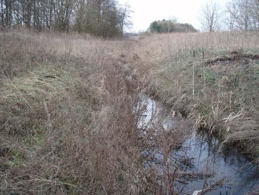
4 There is one designated conservation site along the watercourses: Potters Carr SSSI, Cranworth, an area of alder carr and wet pastureland. A large proportion of land in the catchments is under environmental stewardship schemes, ranging from Entry Level Stewardship to Countryside Stewardship Scheme. Land use in the catchments is predominantly arable agriculture. 3.0 Habitat Assessment 3.1 Blackwater The source of the Blackwater is close to Saham Grove (TF933065), west of Shipdham; the river here is very small (Photo 1) and flows east under a minor road (Photo 2) then the A1075 towards Shipdham before turning south-east. The river is essentially a field drain here, being straightened and lowered. It is unlikely that trout would be found in these very upper reaches because of the small channel size and low volume of water present. A track crosses the river at TF ; the river here is larger and of a size where trout would be expected to be present. The channel is straightened and lacks a natural pool-riffle sequence, but channel vegetation management appears to be relatively light providing some cover within the channel and a gravel bed is present. A wide field margin is present on the left bank downstream of the track. The bridge culvert does not form an obstacle to fish movement (Photos 3-5). The river is of similar character near Cranworth at TF More bankside trees are present here (hawthorn) and wide field margins are present downstream of the track on the RHB. The bridge culvert does not form an obstacle to fish passage (Photos 6, 7). 4


5 Photo 1 Blackwater near the source at Saham Grove (TF933065) Photo 2 Blackwater at road bridge at TF


6 Photo 3 Upstream view, track crossing at TF Photo 4 Downstream view, track crossing at TF


7 Photo 5 Bridge culvert, track crossing at TF Photo 6 Near Cranworth, TF976045, upstream view 7

8 Photo 7 Near Cranworth, TF downstream view 8
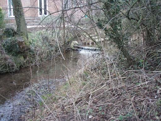
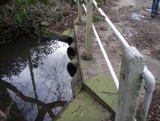
9 The road bridge south of Cranworth (TF987039) comprises an arched brick culvert which takes all the river flow at normal levels, plus three higher level pipes for higher flows (Photos 8, 9). Fish passage is possible through the existing arrangement (via the brick arch), but low, rounded baffles on the base of this culvert would improve the situation. In-stream habitat is better in the vicinity of the bridge, with a less straight planform and the presence of more varied riparian vegetation including trees (Photo 10). At White Bridge near Southburgh the riparian habitat is better than upstream sections, with mature trees present and relatively low, scrubby banks (Photos 11, 12). The in-stream habitat however lacks variety; there is an absence of a pool-riffle sequence and the depth is uniform and shallow. Further downstream towards Calveley Hall the river is split into two channels around a series of disused, concrete trout rearing tanks (Photo 14). Just downstream of this point there is a short section of river with excellent instream habitat; large woody debris is present and the river has scoured deeper pools and cleaned and sorted gravel (Photo 15). Immediately downstream, the river enters a series of on-line lakes. Although Ordnance Survey maps show the river bypassing the lakes to the north, no evidence of a river bypass channel was found on site at the upstream end of the lakes. However, further downstream at Bridge Farm (Photo 16), the outflow from the most downstream lake does join a channel on the north side; this may emanate from other lake overspills or springs. It was not possible to gain access along the whole length of the lakes to verify the existing situation, but it does appear that there is no direct route for fish passage around the lake complex. Further investigation is required with a view to creating a bypass channel around the lakes and providing continuous river habitat. At Blackwater Bridge (TG022049) riparian habitat was good, but in-stream again lacked variation in depth, being mostly shallow glide (Photos 17, 18). Conversation with a local farmer revealed that his son did fish in this area and had observed trout. 9


10 Photo 8 Road bridge culvert, Blackwater TF Photo 9 Road bridge culvert, Blackwater TF


11 Photo 10 Downstream view from road bridge, Blackwater TF Photo 11 Upstream view from White Bridge near Southburgh, Blackwater TF


12 Photo 12 Downstream view from White Bridge near Southburgh, Blackwater TF Photo 13 Upstream view, Blackwater TG


13 Photo 14 Upstream view showing disused trout rearing tanks, Blackwater TG Photo 15 Blackwater immediately downstream of Photo 14 some excellent in-stream habitat with large woody debris, scour pools, a good depth variety and well-sorted gravel substrate 13
, Bridge")

14 Photo 16 Outflow from the lake (background and left) and upstream view of river channel (centre), Bridge Farm, Blackwater, TG Arrow indicates flow direction. Photo 17 Upstream view from Blackwater Bridge, TG


15 Photo 18 Downstream view from Blackwater Bridge, TG Photo 19 Upstream view from Dereham Road bridge (TG028055). River impounded above structure shown in Photo


16 Photo 20 Dereham Road bridge culvert, near Reymerston. A major obstacle to free passage of fish. Blackwater TG Photo 21 A smaller obstacle to fish passage a short distance downstream of Photo 20 16

17 Photo 22 Very good in-stream habitat downstream of the road bridge at TG for about 500 metres, alongside a nature reserve on the RHB. 17

18 Photo 23 Part of the section of the Blackwater that was the subject of a river restoration carried out approximately 10 years ago By Prof. Richard Hey following gravel quarrying, Blackwater TG
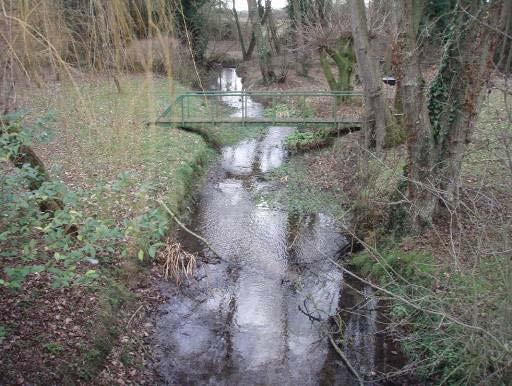
19 At Dereham Road bridge near Reymerston, the bridge culvert poses a significant obstruction to upstream fish passage, having an approximately 1- metre head difference across a vertical sheet-pile weir (Photo 20). Improving fish passage here would be most cost-effectively achieved by the construction of a rock ramp, or series of pre-barages downstream of the weir. Upstream of the bridge the river is impounded, straight and shallow, with a bed dominated by fine sediment; there is space on the LHB here for river channel re-routing (adjacent to the golf course, Photo 19). A short distance downstream are two much smaller structures that are likely to be passable by fish (Photo 21) and could easily be improved by notching. Downstream of this point for approximately 500m, the river habitat is excellent. A pool-riffle sequence is present with many natural features including gravel shoals and point bars, woody debris and deep pools bordered by tree roots. The left bank here is a land-filled gravel pit which appears to have been over-filled creating very steep banks down to the river; the right bank is much lower and is signed as a wildlife area. Both banks are wooded, mainly with young alder trees of a similar size/age (about 20-cm trunk diameter). With progress downstream the channel becomes wider and shallower with fewer in-stream features. The next point inspected was adjacent to Hardingham Church alongside the lakes (former gravel pits). A section of river here was the subject of a river restoration project (following gravel extraction) supervised by Professor Richard Hey (pers. comm.). The project involved the re-creation of a river channel with a meandering planform, pool-riffle sequence and functioning floodplain, between the approximate grid references TG and TG (Photo 23). Summary of Identified Pressures affecting trout populations Blackwater 1. Extensive channel modification for drainage (straightening, bed lowering), for the majority of the river length inspected resulting in impoverished habitat for fish. 2. Two significant obstructions to the free movement of fish, one at Dereham Road bridge (TG028055) and another at the on-line lakes near Calveley Hall (TG015048). 19
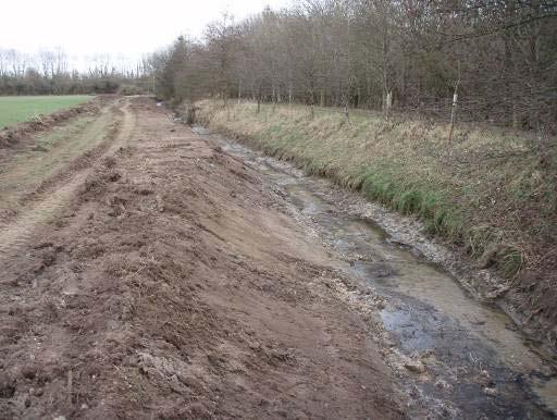
20 3.2 Upper Yare The source of the Upper Yare is north-east of Shipdham at TF The river is culverted for approximately 1 km under Shipdham airfield and inspection at Park Farm (south of Whinburgh, TG003084) showed the river is very small at this point (Photo 24). Downstream of the B1135 road bridge north of Garvestone (TG013085), the river has been recently dredged (Photo 25) for a length of approximately 400 m. The left bank has been battered back to a 30-degree angle and the river bed lowered by about 20 cm. The bed lowering has left only fine bed substrate and appears to have effectively increased the height of the weir immediately below the road bridge, and hence the obstacle to fish movement (Photo 26). It is thought that the works are not consented by the Environment Agency and it is obvious that no consideration has been given to habitat for fish or other wildlife. No meaningful in-stream habitat remains along this length. Ironically, this length of river appears to border land on the LHB in a Countryside Stewardship agreement. Upstream of Garvestone village the river is straight, wide and shallow; it flows alongside residential properties coming into the village and some low, presumably ornamental, weirs are present (Photos 27, 28). There is a ford in the village consisting of pipes under the road for low flows and a lowered road surface for higher flows; this is potentially an obstacle to fish movement, especially if the pipes block (Photo 29). Between Garvestone and Thuxton, the river has more natural features although at the time of the visit flows appeared to be very low. Rainfall has been exceptionally low in recent months, but it would be worth investigating abstractions in this catchment to assess their potential impact. Some parts of this section were heavily shaded by marginal hedges (hawthorn) and would benefit from sensitive riparian tree management (Photo 30). In Thuxton, a brook joins the river from the west, via a bridge culvert under the railway line (Photo 32); fish access could be improved here by installing baffles on the culvert base. The brook itself was overwide and shallow within the village (Photo 31). 20

21 Photo 24 Photo 25 21

22 Photo 26 Photo 27 22

23 Photo 28 Photo 29 23

24 Photo 30 Photo 31 24

25 Photo 32 Photo 33 25
26 Downstream of Thuxton, the river has a meandering planform but becomes straightened alongside the railway line before circumventing a stillwater trout fishery. The river channel here is incised, straight and slow-flowing (Photo 33). A short distance downstream is the confluence of the Yare and Blackwater. Summary of Identified Pressures affecting trout populations Upper Yare 1. Extensive channel modification for drainage (straightening, bed lowering), for the majority of the river length inspected resulting in impoverished habitat for fish. 2. Obstruction to the free movement of fish at B1135 road bridge (TG013085) and other lesser obstructions (railway bridge culvert in Thuxton TG032071, ford and ornamental weirs at Garvestone TG024080). 4.0 Conclusions and Recommendations The reason this waterbody is failing to reach good potential for fish is because of poor in-stream habitat resulting from extensive channel engineering works and subsequent maintenance. The re-grading and realignment of the river has disrupted the natural morphology of the channel, leading to an absence of habitat features necessary to support healthy fish populations. This process is ongoing, as evidenced by the recent dredging described above. To improve the status of this waterbody for fish, the in-stream habitat needs to be improved. To do this sustainably, the physical processes controlling channel shape and dimensions need to be considered in detail (via a geomorphological survey) and restoration design options considered. Options may be constrained by the availability of space, finance and the need to retain specific river functions (e.g. land drainage, flood alleviation) (Hey, 2000). The ideal restoration scenario is one with none of the above constraints, resulting in restoration of the original river morphology (or a naturalised channel appropriate for current climate and catchment conditions) and reconnection to the floodplain. Realistically there will be constraints 26
27 (probably in this case to retain a land drainage function) meaning the options are likely to be: Creating a new, lower level floodplain and a meandering channel at the existing bed level within this. The width of the lowered floodplain depends on required flood capacity, but should extend beyond the belt width of the new meandering channel as a minimum. Use of structures (deflectors, riffles, vanes, woody debris) introduced to the existing channel to create localised scour and hence variation in depth and substrate composition. The former option is more expensive (around 50K - 250K depending upon extent) and requires more land, but is a more sustainable, long-term solution which works with the rivers natural processes; the latter option is less expensive (around 10K to 50K depending upon extent) but the improvements may be less effective or long-lasting. For any form of river restoration to be successful, it is vital that landowners and land managers are fully engaged with the process. There is a long tradition of watercourse management purely for land drainage and agriculture in this area (much of it carried out by Environment Agency predecessor organisations), so a process of engagement, explanation and consultation is necessary to communicate the aims and objectives of the Water Framework Directive and attaining Good Ecological Status. 5.0 Making it Happen The following steps could be undertaken in order to progress a restoration project: Undertake a consultation with local interested parties, including landowners and the wider community, to explain the goals and objectives and to identify constraints. Use existing areas of good/restored river habitat (Blackwater, downstream of Dereham Road, Reymerston) as example areas. Identify suitable areas and local landowners willing to participate in river restoration and obtain agreement. Potential areas for 27
28 improvement identified during the current visit include the White Bridge (TF997044) to Dereham Road bridge (TG028057) section of the Blackwater; the aims of a project here should include in-stream habitat restoration, restoring connectivity around the lake complex and improving fish passage over the barrier at Dereham Road. Undertake a geomorphological survey of the reach and appraisal of options for restoration, including indicative costs. Identify the preferred option, draw up detailed design, obtain necessary consents and funding and carry out works. 6.0 Acknowledgement The Wild Trout Trust would like to thank the Environment Agency for the support which made this visit possible. 7.0 Disclaimer This report is produced for guidance only and should not be used as a substitute for full professional advice. Accordingly, no liability or responsibility for any loss or damage can be accepted by the Wild Trout Trust as a result of any other person, company or organisation acting, or refraining from acting, upon comments made in this report. 28
29 References Hey, R.D. (2000) River habitat restoration in canalised watercourses: possibilities and constraints. Paper presented at CONNECT Workshop, 6-8 November, Lillehammer, Norway. 29
River Medway Upper Medway Fly Fishers
 River Medway Upper Medway Fly Fishers An Advisory Visit by the Wild Trout Trust April 2015 1 1. Introduction This report is the output of a site meeting and walk-over survey of a 2-km stretch of the River
Advisory Visit. Bradshaw Brook, Lancashire. August 2010
 Advisory Visit Bradshaw Brook, Lancashire August 2010 1.0 Introduction This report is the output of a site visit undertaken by Tim Jacklin of the Wild Trout Trust to the Bradshaw Brook, Bolton, Lancashire
Cornwell brook Cornwell Manor
 Cornwell brook Cornwell Manor An Advisory Visit by the Wild Trout Trust February 2014 1 1. Introduction This report is the output of a Wild Trout Trust visit to a tributary of the Cornwell Brook at Cornwell
HABITAT ADVISORY VISIT TO THE RIVER ITCHEN, CHERITON BISHOP, HAMPSHIRE.
 HABITAT ADVISORY VISIT TO THE RIVER ITCHEN, CHERITON BISHOP, HAMPSHIRE. UNDERTAKEN BY VAUGHAN LEWIS, WINDRUSH AEC LTD ON BEHALF OF SUSSEX PISCATORIAL SOCIETY DECEMBER 2005 Sponsored by: 1.0 Introduction
River Leach Cotswold Fly Fishers
 River Leach Cotswold Fly Fishers A Project Proposal by the Wild Trout Trust - April 2015 1 1. Introduction This report is the output of a site visit to the River Leach on water controlled by the Cotswold
THE RIVER ALUN (aka ALYN)
") THE RIVER ALUN (aka ALYN) Advisory Visit Report Undertaken On behalf of the Wild Trout Trust By Ron Holloway MIFM 22 nd April 2002-04-25 The River Alun The Rossett & Gresford Fly Fishing Club R H Associates
THE RIVER ALUN (aka ALYN) Advisory Visit Report Undertaken On behalf of the Wild Trout Trust By Ron Holloway MIFM 22 nd April 2002-04-25 The River Alun The Rossett & Gresford Fly Fishing Club R H Associates
River Crane Cranford Park
 River Crane Cranford Park A Project Proposal by the Wild Trout Trust December 2015 1 1. Introduction This report is the output of a site meeting and walk-over survey of a 1-km stretch of the River Crane
Advisory Visit / Walkover Survey. River Tean Staffordshire. February 2016
 Advisory Visit / Walkover Survey River Tean Staffordshire February 2016 Table of Contents Summary of main findings... 2 1.0 Introduction... 3 2.0 Catchment / Fishery Overview... 3 3.0 Habitat Assessment...
Advisory Visit. Brailsford Brook, Derbyshire
 Advisory Visit Brailsford Brook, Derbyshire July 2015 1.0 Introduction This report is the output of a site visit undertaken by Tim Jacklin of the Wild Trout Trust to the Brailsford Brook, Ednaston, Derbyshire
Rehabilitation of Grimes Creek, a Stream Impacted in the Past by Bucket-lined Dredge Gold Mining, Boise River Drainage, July 2008 to August 2011.
 Rehabilitation of Grimes Creek, a Stream Impacted in the Past by Bucket-lined Dredge Gold Mining, Boise River Drainage, July 2008 to August 2011. Pam Harrington TU,1020 W. Main Street Suite 440, Boise,
OKANAGAN RIVER RESTORATION INITIATIVE - FAQ
 OKANAGAN RIVER RESTORATION INITIATIVE - FAQ Initiative background: The health of the q awsitk w (Okanagan River) has been severely impacted by the channelization works that occurred in the mid-1950 s.
River Semington West Lavington
 River Semington West Lavington An advisory visit carried out by the Wild Trout Trust December 2009 1. Introduction This report is the output of a Wild Trout Trust advisory visit undertaken on the headwaters
Know Your River - River Ogmore Salmon and Sea Trout Catchment Summary
 Know Your River - River Ogmore Salmon and Sea Trout Catchment Summary Introduction This report describes the status of the salmon and sea trout populations in the Ogmore catchments. Bringing together data
HABITAT ADVISORY VISIT TO THE RIVER CERNE, DORSET. UNDERTAKEN BY VAUGHAN LEWIS, WINDRUSH AEC LTD ON BEHALF OF THE GALLIA FAMILY
 HABITAT ADVISORY VISIT TO THE RIVER CERNE, DORSET. UNDERTAKEN BY VAUGHAN LEWIS, WINDRUSH AEC LTD ON BEHALF OF THE GALLIA FAMILY APRIL 2008 1.0 Introduction This report is the output of a site visit undertaken
Know Your River River Loughor Salmon and Sea Trout Catchment Summary
 Know Your River River Loughor Salmon and Sea Trout Catchment Summary Introduction This report describes the status of the salmon and sea trout populations in the Loughor catchments. Bringing together data
Illinois Lake Management Association Conference March 23, 2018 By Trent Thomas Illinois Department of Natural Resources Division of Fisheries
 Illinois Lake Management Association Conference March 23, 2018 By Trent Thomas Illinois Department of Natural Resources Division of Fisheries Sources of Habitat Impairment Sedimentation Channelization
Advisory Visit. Tributary of Repton Brook, Derbyshire
 Advisory Visit Tributary of Repton Brook, Derbyshire July 2017 1 1.0 Introduction This report is the output of a site visit undertaken by Tim Jacklin of the Wild Trout Trust to a headwater tributary of
MCCAW REACH RESTORATION
 Final Report MCCAW REACH FISH RESTORATION PHASE B Jack McCaw Inland Empire Action Coalition http://www.wwccd.net/ Phone: 509-956-3777 Hours: 8:00-4:30 Walla Walla County Conservation District Snake River
How Capel Brook An advisory visit carried out by the Wild Trout Trust July 2010
 How Capel Brook An advisory visit carried out by the Wild Trout Trust July 2010 1. Introduction This report is the output of a Wild Trout Trust advisory visit undertaken on the How Capel Brook, one of
Fish population survey report
 Fish population survey report Upper River Avon Catchment This report provides a summary of results from recent fish population surveys on the Tetbury Avon, Sherston Avon and River Marden The surveys were
Advisory Visit. River Irthing, Cumbria. 7 th July, 2010
 Advisory Visit River Irthing, Cumbria 7 th July, 2010 1.0 Introduction This report is the output of a site visit undertaken by Tim Jacklin of the Wild Trout Trust to the River Irthing, Cumbria on 7 th
Guidance Note. Hydropower Guidance Note: HGN 8 Fish Passage. When do you need to install a fish pass?
 Guidance Note Hydropower Guidance Note: This guidance note is not intended as a statement of law. It should be read in combination with, and in the context of, the relevant enactments and EU obligations.
COA-F17-F-1343 YEAR END REPORT
 DAVE MARSHALL SALMON RESERVE RESTORATION, MAINTENANCE, AND UPGRADES YEAR END REPORT Prepared for: Fish and Wildlife Compensation Program Prepared by: Edith Tobe, RPBio, Executive Director Box 1791, Squamish,
Know Your River River Afan Salmon and Sea Trout Catchment Summary
 Know Your River River Afan Salmon and Sea Trout Catchment Summary Introduction This report describes the status of the salmon and sea trout populations in the Afan catchments. Bringing together data from
River Dun, Froxfield, Wiltshire
 River Dun, Froxfield, Wiltshire An Advisory Visit by the Wild Trout Trust, January and April 2014 Contents Introduction 3 Catchment and Fishery Overview 4 Habitat Assessment 5 Recommendations 13 Making
Advisory Visit Report. River Charentonne, Normandy, France. Undertaken By Simon Johnson. On behalf of the International Fario Club, Paris
 Advisory Visit Report River Charentonne, Normandy, France Undertaken By Simon Johnson On behalf of the International Fario Club, Paris September 2006 1.0 Introduction This report is the output of a site
FISH PASSAGE IMPROVEMENT in California s Watersheds. Assessments & Recommendations by the Fish Passage Forum
 FISH PASSAGE IMPROVEMENT in California s Watersheds Assessments & Recommendations by the Fish Passage Forum FISH PASSAGE IMPROVEMENT in California s Watersheds The mission of the Fish Passage Forum is
River Restoration: Culvers Island weir removals and river naturalisation project.
 River Restoration: Culvers Island weir removals and river naturalisation project. Background Chalk streams are an incredibly rare habitat on a global scale, and owing to their international importance,
Minnesota Department of Natural Resources Division of Fish and Wildlife Section of Fisheries. Stream Survey Report. Luxemburg Creek.
 Minnesota F-29-R(P)-24 Area 315 Study 3 March 2016 Minnesota Department of Natural Resources Division of Fish and Wildlife Section of Fisheries Stream Survey Report Luxemburg Creek 2015 Mark Pelham Sauk
Sherford Stream, Taunton
 Sherford Stream, Taunton An Advisory Visit Report by the Wild Trout Trust Contents Introduction 3 Catchment and Fishery Overview 5 Habitat Assessment 6 Conclusion 17 Recommendations 17 Making it Happen
Interim Guidance Fish Presence Absence
 Interim Guidance Fish Presence Absence Source: Forest Practices Act Guidance for Division 635 of the forest practices act dealing with stream classification when no fish surveys have been done (referenced
Steelhead Society of BC. Thompson River Watershed Restoration and Enhancement Project #4 Nicola River Bank Stabilization and Enhancement Project
 Steelhead Society of BC Presents: Thompson River Watershed Restoration and Enhancement Project #4 Nicola River Bank Stabilization and Enhancement Project Application for Funding December 2013 1.0 BACKGROUND
Habitat Advisory visit to the River Fergus system Co.Clare, Eire. Undertaken on behalf of Ennis and District Anglers Association, by Vaughan Lewis,
 Habitat Advisory visit to the River Fergus system Co.Clare, Eire. Undertaken on behalf of Ennis and District Anglers Association, by Vaughan Lewis, Windrush AEC Ltd April 2006 1.0 Introduction This report
The Spey Catchment Initiative
 The Spey Catchment Initiative Introducing the Spey Catchment Initiative The Spey Catchment Initiative is a new project which aims to help deliver the objectives of the River Spey Catchment Management Plan
Big Spring Creek Habitat Enhancement and Fishery Management Plans
 Big Spring Creek Habitat Enhancement and Fishery Management Plans November 5, 2012 Big Spring Events and Activities Center Newville, PA Charlie McGarrell Regional Habitat Biologist Pennsylvania Fish and
Know Your River River Neath Salmon and Sea Trout Catchment Summary
 Know Your River River Neath Salmon and Sea Trout Catchment Summary Introduction This report describes the status of the salmon and sea trout populations in the Neath catchments. Bringing together data
Throughout the report, normal convention is followed, with right bank (RB) and left bank (LB) of the river identified when looking downstream.
 and left bank (LB) of the river identified when looking downstream.") Habitat Advisory visit to the River Robe, Co. Mayo, Eire. Undertaken on behalf of the River Robe Angling Club by Vaughan Lewis, Windrush AEC Ltd May 2013 1.0 Introduction This report forms the output of
Habitat Advisory visit to the River Robe, Co. Mayo, Eire. Undertaken on behalf of the River Robe Angling Club by Vaughan Lewis, Windrush AEC Ltd May 2013 1.0 Introduction This report forms the output of
Know Your River Conwy Salmon & Sea Trout Catchment Summary
 Know Your River Conwy Salmon & Sea Trout Catchment Summary Introduction This report describes the status of the salmon and sea trout populations in the Conwy catchment. Bringing together data from rod
Know Your River Conwy Salmon & Sea Trout Catchment Summary
 Know Your River Conwy Salmon & Sea Trout Catchment Summary Introduction This report describes the status of the salmon and sea trout populations in the Conwy catchment. Bringing together data from rod
FISH PASSAGE ALTERNATIVES ANALYSIS ON PENNYPACK CREEK AT VERREE ROAD DAM AND ROOSEVELT BOULEVARD DAM PHILADELPHIA, PENNSYLVANIA
 FISH PASSAGE ALTERNATIVES ANALYSIS ON PENNYPACK CREEK AT VERREE ROAD DAM AND ROOSEVELT BOULEVARD DAM PHILADELPHIA, PENNSYLVANIA Prepared for: One Parkway, 10 th Floor 1515 Arch Street Philadelphia, PA
Rivers and Wetlands Community Days Project Profile
 Rivers and Wetlands Community Days Project Profile Title: Restoring River Windrush Riverbanks Date of application: February 2016 Contact name/organisation: Richard Spyvee, Gloucestershire Wildlife Trust
Identifying and Executing Stream Projects Kristin Thomas, Aquatic Ecologist MITU
 Identifying and Executing Stream Projects Kristin Thomas, Aquatic Ecologist MITU Introduction 1. Methods for Identifying Projects 2. Methods in Action 3. The Partnership Paradigm 2 River Stewards Program
Little Kern Golden Trout Status:
 Little Kern Golden Trout Status: The Little Kern Golden trout (LKGT) was proposed for federal listing as Threatened under the Endangered Species Act (ESA) on September 1, 1977 by the U. S. Fish and Wildlife
Know Your River - Clwyd Salmon & Sea Trout Catchment Summary
 Know Your River - Clwyd Salmon & Sea Trout Catchment Summary Introduction This report describes the status of the salmon and sea trout populations in the Clwyd catchment. Bringing together data from rod
Fish Habitat Restoration and Monitoring in Southeast Washington. Andy Hill Eco Logical Research, Inc.
 Fish Habitat Restoration and Monitoring in Southeast Washington Andy Hill Eco Logical Research, Inc. Fish Habitat Restoration and Monitoring in Southeast Washington Talk overview: Restoration projects
River Darent Darent Valley Trout Fishers
 River Darent Darent Valley Trout Fishers An advisory visit carried out by the Wild Trout Trust April 2010 1. Introduction This report is the output of a Wild Trout Trust advisory visit undertaken on the
Draft report on one day visit to Brampton Bryan, R. Teme
 Dr Nick Giles & Associates, 50 Lake Road, Verwood, Dorset, BH31 6BX. Telephone 01202 824245 Fax 01202 828056 email nickgiles@cix.co.uk Consultants : Freshwater Fisheries, Conservation & Wetland Ecology
Pearls in Peril (PIP): Securing the future of the freshwater pearl mussel in Great Britain. Layman s Report LIFE project LIFE/NAT/000383: PIP GB
: Securing the future of the freshwater pearl mussel in Great Britain. Layman s Report LIFE project LIFE/NAT/000383: PIP GB") Pearls in Peril (PIP): Securing the future of the freshwater pearl mussel in Great Britain Layman s Report LIFE project LIFE/NAT/000383: PIP GB Where we worked Our aims Restore in-stream habitats for freshwater
Pearls in Peril (PIP): Securing the future of the freshwater pearl mussel in Great Britain Layman s Report LIFE project LIFE/NAT/000383: PIP GB Where we worked Our aims Restore in-stream habitats for freshwater
Aquatic Organism Passage at Road-Stream Crossings CHUCK KEEPORTS FOREST HYDROLOGIST ALLEGHENY NATIONAL FOREST WARREN, PENNSYLVANIA
 Aquatic Organism Passage at Road-Stream Crossings CHUCK KEEPORTS FOREST HYDROLOGIST ALLEGHENY NATIONAL FOREST WARREN, PENNSYLVANIA TOPICS COVERED Aquatic Organism Passage (AOP) Benefits of AOP Crossings
STREAM SURVEY File form No..
 scanned for KRIS THE RESOURCES AGENCY OF CALIFORNIA California Department of Fish and Game STREAM SURVEY File form No.. Date: September 4, 1969. NAME: North Fork Schooner Gulch Creek COUNTY: Mendocino.
Management of headwater streams in the White Mountain National Forest
 Management of headwater streams in the White Mountain National Forest White Mountain National Forest Weeks Act of 1911 authorized the federal government to purchase lands east of the Mississippi River
Trout Unlimited Comments on the Scope of Environmental Impact Statement for the Constitution Pipeline Project, Docket No. PF12-9
 October 9, 2012 Kimberly D. Bose, Secretary Federal Energy Regulatory Commission 888 First Street, NE, Room 1A Washington, DC 20426 RE: Trout Unlimited Comments on the Scope of Environmental Impact Statement
Otter and Water Vole Survey Land off Harrogate Road, Spofforth
 Otter and Water Vole Survey Land off Harrogate Road, Spofforth Report Reference: R-2925-04.1 Report Title: Otter and Water Vole Survey Land off Harrogate Road, Spofforth Report Reference: R-2925-04.1 Written
Report prepared for: Prepared by: January 2002 BEAK Ref
 AQUATIC ENVIRONMENTAL STUDY KANATA WEST CONCEPT PLAN Report prepared for: ROBINSON CONSULTANTS Prepared by: BEAK INTERNATIONAL INCORPORATED 14 Abacus Road Brampton, Ontario L6T 5B7 January 2002 BEAK Ref.
Great Lakes Stream Crossing Inventory Instructions
 Great Lakes Stream Crossing Inventory Instructions This document is a guide to completing the Stream Crossing Data Sheet (2/28/11 version). Careful attention to this guidance will ensure consistent crossing
FINAL REPORT. Yonkers Creek Migration Barrier Removal Project Wonderstump Road Del Norte County. Submitted By:
 FINAL REPORT Yonkers Creek Migration Barrier Removal Project Wonderstump Road Del Norte County Submitted By: Del Norte County Community Development Department Yonkers Creek Migration Barrier Removal Project
Hydraulic Modeling of Stream Enhancement Methods
 Hydraulic Modeling of Stream Enhancement Methods Matthew J. Curry John J. Levitsky Abstract Development within watersheds increases the amounts of runoff causing stream erosion and degradation of stream
HABITAT ADVISORY VISIT, RIVER LAMBOURN, BERKSHIRE, UNDERTAKEN BY VAUGHAN LEWIS, WINDRUSH AEC ON BEHALF OF LAMBOURN FLYFISHERS. MAY
 HABITAT ADVISORY VISIT, RIVER LAMBOURN, BERKSHIRE, UNDERTAKEN BY VAUGHAN LEWIS, WINDRUSH AEC ON BEHALF OF LAMBOURN FLYFISHERS. MAY 2002 Sponsored by: 1.0 Introduction This report is the output of a site
Fish Passage Culvert Assessment for Cahilty Creek Watershed FIA Project #
 Fish Passage Culvert Assessment for Cahilty Creek Watershed FIA Project # 4602004 Prepared for Weyerhaeuser Company Ltd. Jason Ladyman R.P.F. 1550 Mission Flats Road PO Box 40 Kamloops BC V2C 5K3 Prepared
REPORT OF PHASE 1 OF AN EASTERN TAY DISTRICT RIPARIAN SURVEY. David Summers and Robert Mitchell Tay Foundation May 2010
 REPORT OF PHASE 1 OF AN EASTERN TAY DISTRICT RIPARIAN SURVEY 1. INTRODUCTON David Summers and Robert Mitchell Tay Foundation May 2010 The eastern half of the Tay district mainly consists of arable farmland
Mid-Columbia Fisheries Enhancement Group Annual Report Fiscal Year 06: July 1, 2005 June 30, 2006
 Mid-Columbia Fisheries Enhancement Group Annual Report Fiscal Year 06: July 1, 2005 June 30, 2006 Mission Statement The mission of the Mid-Columbia Fisheries Enhancement Group is to restore self-sustaining
Fish population survey report
 Fish population survey report River Teme 2016 This report provides a summary of results from recent coarse fish population surveys on the River Teme between Tenbury Wells and Powick. The surveys were carried
IFM SCOTLAND S CODE of GOOD PRACTICE for FRESHWATER FISHERIES MANAGEMENT part 1: Salmon & Trout
 IFM SCOTLAND S CODE of GOOD PRACTICE for FRESHWATER FISHERIES MANAGEMENT part 1: Salmon & Trout Guides to freshwater fisheries management have been one of the pillars of the British publishing industry
(Revised February,2005) CULVERTS, BRIDGES, AND FORDS
 CULVERTS, BRIDGES, AND FORDS") GUIDE TO STREAM CROSSINGS (Revised February,2005) CULVERTS, BRIDGES, AND FORDS Culverts, bridges, and fords are all methods used to cross-streams. Culverts are the most common stream crossing structure.
GUIDE TO STREAM CROSSINGS (Revised February,2005) CULVERTS, BRIDGES, AND FORDS Culverts, bridges, and fords are all methods used to cross-streams. Culverts are the most common stream crossing structure.
The Black Bourn An Advisory Visit by the Wild Trout Trust January 2016
 The Black Bourn An Advisory Visit by the Wild Trout Trust January 2016 1. Introduction This report is the output of a site visit to the Black Bourn, also known as the River Sapiston. The Black Bourn is
Holderness. The Three Watersheds within the Newfound Lake Drainage Dorchester. Groton Plymouth. Ashland. Hebron. Canaan. Bridgewater.
 Background Brook trout are the only native stream dwelling trout species in New Hampshire, having a historic range that extended from Georgia to eastern Canada. It is believed that wild brook trout were
THE DON DISTRICT SALMON FISHERY BOARD RIVER DON DRAFT GRAVEL MANAGEMENT PLAN NEWE DAM
 THE DON DISTRICT SALMON FISHERY BOARD RIVER DON DRAFT GRAVEL MANAGEMENT PLAN NEWE DAM Introduction The Newe Dam at Strathdon is situated on the upper reaches of the river Don catchment area, Grid Reference
1.Mill Creek Watershed Summary Description and Land Use
 1.Mill Creek Watershed Summary Description and Land Use Table xxx: Mill Creek Watershed Overview Watershed Size 31,435 acres/49.1 sq miles/ 127.1 sq km Elevation Range 5,594 feet [4,967-10,561] Stream
Massachusetts Stream Crossing Case Studies
 Massachusetts Stream Crossing Case Studies Amy Singler Associate Director, River Restoration Program Carrie Banks River Continuity Coordinator Case Studies: Public Benefits: Movement of goods and people
Culvert Design for Low and High Gradient Streams in the Midwest. Dale Higgins, Hydrologist Chequamegon-Nicolet National Forest
 Culvert Design for Low and High Gradient Streams in the Midwest Dale Higgins, Hydrologist Chequamegon-Nicolet National Forest Overview Culvert Design Considerations Hydraulic Terms Culvert Impacts Low
Pillhill Brook, Monxton, Hampshire
 Pillhill Brook, Monxton, Hampshire An Advisory Visit by the Wild Trout Trust, March 2014 Contents Introduction 3 Catchment and Fishery Overview 4 Habitat Assessment 6 Recommendations 12 Making it Happen
Assessing Ecosystem Impacts from Road Stream Crossings through Community Involvement
 Assessing Ecosystem Impacts from Road Stream Crossings through Community Involvement Background Why is the NH Fish and Game Department interested in culverts? Block fish migration Reduce opportunities
Climate Change Adaptation and Stream Restoration. Jack Williams;
 Climate Change Adaptation and Stream Restoration Jack Williams; jwilliams@tu.org 1 Goals for this presentation Develop strategies for adapting streams to climate impacts by Thinking like a watershed Understanding
Floating Pennywort Project. River Medway and River Cray locations
 Floating Pennywort Project River Medway and River Cray locations 2011 Andrea Griffiths (BSc) Partnership Officer Medway Valley Countryside Partnership MVCP Floating Pennywort Report 2011 Andrea Griffiths
Five Counties Salmonid Conservation Program - Fish Passage Design Workshop. February 2013
 Program - Aquatic Organisms and Stream Crossings Ecological Connectivity A watershed is a network of channels that drain a common boundary. Channel characteristics formed by interaction of precipitation,
Does DFO Need to Review My Project?
 Working Together for Responsible Erosion & Sediment Control Workshop Does DFO Need to Review My Project? June 6, 2014 Fisheries Protection Program Department of Fisheries and Oceans Amendments to the Fisheries
River Afan Afan Valley Angling Club
 River Afan Afan Valley Angling Club An advisory visit carried out by the Wild Trout Trust February 2010 1. Introduction This report is the output of a Wild Trout Trust advisory visit undertaken on the
NASCO Guidelines for the Protection, Restoration and Enhancement of Atlantic Salmon Habitat
 NASCO Guidelines for the Protection, Restoration and Enhancement of Atlantic Salmon Habitat 1 NASCO Guidelines for the Protection, Restoration and Enhancement of Atlantic Salmon Habitat Additional copies
Schedule for Culvert Works in or on the Bed or Bank of a Watercourse PLEASE READ THIS PAGE BEFORE COMPLETING THE APPLICATION FORM
 10A Schedule for Culvert Works in or on the Bed or Bank of a Watercourse This form is to be used for applications to use, erect, place, extend, alter or replace a culvert in or on the beds or banks of
STUDY PERFORMANCE REPORT
 STUDY PERFORMANCE REPORT State: Michigan Project No.: F-80-R-4 Study No.: 702 Title: Effects of sediment traps on Michigan river channels Period Covered: October 1, 2002 to September 30, 2003 Study Objectives:
Know Your River - Clwyd Salmon & Sea Trout Catchment Summary
 Know Your River - Clwyd Salmon & Sea Trout Catchment Summary Introduction This report describes the status of the salmon and sea trout populations in the Clwyd catchment. Bringing together data from rod
Chadbourne Dam Repair and Fish Barrier
 Chadbourne Dam Repair and Fish Barrier Final Report for the Western Native Trout Initiative Prepared by: Carol Endicott Yellowstone Cutthroat Trout Conservation Biologist Montana Fish, Wildlife & Parks
ADVISORY VISIT TO THE RIVER ALLEN, DORSET UNDERTAKEN BY VAUGHAN LEWIS, WINDRUSH AEC LTD, ON BEHALF OF GAUNTS FISHERY MAY 2006
 ADVISORY VISIT TO THE RIVER ALLEN, DORSET UNDERTAKEN BY VAUGHAN LEWIS, WINDRUSH AEC LTD, ON BEHALF OF GAUNTS FISHERY MAY 2006 Sponsored by: 1.0 Introduction This report is based on a visit to the River
Merkinch Greenspace. Merkinch Local Nature Reserve: Hydrological Assessment
 Merkinch Local Nature Reserve: Hydrological Assessment June 2011 EnviroCentre Craighall Business Park Eagle Street Glasgow G4 9XA t 0141 341 5040 f 0141 341 5045 w www.envirocentre.co.uk e info@envirocentre.co.uk
South Fork Chehalis Watershed Culvert Assessment
 South Fork Chehalis Watershed Culvert Assessment Water Resource Inventory Area 23 Lewis County Conservation District Final Report By: Kelly Verd and Nikki Wilson March 2003 Funded by: The Washington State
Environmental Review and Permitting for Wild Trout
 Environmental Review and Permitting for Wild Trout Tom Shervinskie Wild Trout Summit Watershed Analysis Section August 26, 2017 Division of Environmental Services The mission of the Pennsylvania Fish and
Presented by Fred Halterman, URS Jennie Agerton, URS
 Presented by Fred Halterman, URS Jennie Agerton, URS What is Eco Friendly Culvert Design? Culvert design that: Maintains connectivity for aquatic organism migration Maintains connectivity for gene flow
HARRY AND LAURA NOHR CHAPTER OF TROUT UNLIMITED
 HARRY AND LAURA NOHR CHAPTER OF TROUT UNLIMITED BLUE RIVER HABITAT IMPROVEMENT PROJECT 2017 Report Prepared by the Project Committee Harry and Laura Nohr Chapter of Trout Unlimited 1 Sponsorship and Partners
Salmon Five Point Approach restoring salmon in England
 Salmon Five Point Approach restoring salmon in England Our Mission To restore the abundance, diversity and resilience of salmon stocks throughout England We will do this by:- a) Maximising the production
Fish Survey Report and Stocking Advice for Loch Milton. (Loch a Mhuilinn), May 2011
, May 2011") Fish Survey Report and Stocking Advice for Loch Milton (Loch a Mhuilinn), May 2011 Jonah Tosney Freshwater Fisheries Biologist Wester Ross Fisheries Trust 1 Loch Milton (Loch a Mhuilinn) Fish Survey Report
Fish Survey Report and Stocking Advice for Loch Milton (Loch a Mhuilinn), May 2011 Jonah Tosney Freshwater Fisheries Biologist Wester Ross Fisheries Trust 1 Loch Milton (Loch a Mhuilinn) Fish Survey Report
DECEMBER 2003 Instream habitat assessment for the Waikanae River
 DECEMBER 3 Instream habitat assessment for the Waikanae River Laura Watts Resource Investigations Department Executive Summary An instream habitat investigation of the Waikanae River was performed to assess
The Blue Heron Slough Conservation Bank
 1 The Blue Heron Slough Conservation Bank CONSERVATION BANKING July 19-23, 2010 CASE STUDY SERIES The Blue Heron Slough Conservation Bank (Washington) I. OVERVIEW & BACKGROUND: Location: Snohomish River
Restoring the Kootenai: A Tribal Approach to Restoration of a Large River in Idaho
 Restoring the Kootenai: A Tribal Approach to Restoration of a Large River in Idaho Susan Ireland, Kootenai Tribe of Idaho Future of our Salmon Conference Technical Session August 2016 Healthy Floodplains,
Cross-Vane Plan View FIN-UP Habitat Consultants, Inc. 220 Illinois Avenue Manitou Springs, CO (719) P.
 P.") STREAM CHANNEL STRUCTURE DRAWINGS ISIONS W (Channel Width) (Varies) Thalweg & Flow Direction Individually Placed Footer Rocks 5' to 6' by 2' thick (Min. 2 rows of footer rocks placed tightly together with
STREAM CHANNEL STRUCTURE DRAWINGS ISIONS W (Channel Width) (Varies) Thalweg & Flow Direction Individually Placed Footer Rocks 5' to 6' by 2' thick (Min. 2 rows of footer rocks placed tightly together with
RIVER CONONISH INVERTEBRATE SURVEY Dr Kjersti Birkeland
 RIVER CONONISH INVERTEBRATE SURVEY 26 Dr Kjersti Birkeland Background The Cononish, the upper reaches of the River Dochart, should be very important for spring salmon but surveys by the Tay District Salmon
Upper East Stour, Monks Priory, Kent
 Upper East Stour, Monks Priory, Kent Advisory visit May 2016 Key Findings This headwater stream of the East Stour River at Monks Priory supports good quality habitat for brown trout Salmo trutta. The ecological
Advisory Visit 25 th September Rivers Greta & Derwent, Cumbria. On Behalf of Keswick & District Angling Association
 Advisory Visit 25 th September 2007 Rivers Greta & Derwent, Cumbria On Behalf of Keswick & District Angling Association 1.0 Introduction (Advisory Visit) This report is the output of a site visit undertaken
Stevens Creek Corridor
 O F F I C E O F T H E D I R E C T O R O F P U B L I C W O R K S Stevens Creek Corridor Creek Restoration Project Volume Three Project Update: Creek Photos, Before & After BY GAIL SEEDS - PROJECT MANAGER,
Fish Friendly Crossings- Examples from Nash Stream
 Fish Friendly Crossings- Examples from Nash Stream Maggie Machinist- North Regional Forester, Division of Forests and Lands. Nash Stream Nash Stream Forest is 40,000 acres, owned and managed by NH Division
River Test Chilbolton Common
 River Test Chilbolton Common An advisory visit carried out by the Wild Trout Trust September 2011 1 1. Introduction This report is the output of a Wild Trout Trust advisory visit undertaken on a beat of