Past, Present, and Future Fishery Management in Cabinet Gorge and Noxon Rapids Reservoirs
|
|
|
- Franklin Fleming
- 5 years ago
- Views:
Transcription
1 Past, Present, and Future Fishery Management in Cabinet Gorge and Noxon Rapids Reservoirs Abstract Scott S. Rumsey and Joe E. Huston Montana Department of Fish, Wildlife and Parks Kalispell. MT Noxon Rapids and Cabinet Gorge Reservoirs are run-of-the-river hydroelectric impoundments on the Clark Fork River in western Montana. Operations at Noxon Rapids Reservoir changed in 1961 and The first change in operations increased average annual spring drawdown from less than 10 to more than 30 feet. The second eliminated drawdowns of more than 6 feet, except for unusual power demands. Establishment and maintenance of a satisfactory sport fishery has been largely unsuccessful in both reservoirs since the 1950's. Rainbow trout (Salmo gairdneri) exhibited potential from 1958 through 1960 when they produced an excellent fishery, followed by a dramatic decline in Continued planting of rainbow trout never reestablished a substantial fishery. Other fish species planted produced similar results with the exception of brown trout (Salmo trutta) and small mouth bass (Micropterus dolomieui), which presently provide a modest fishery. Largemouth bass (Micropterus salmoides) were present prior to impoundment and appear to be increasing. Operation changes, combined with the brief retention times, have encouraged the downstream movement of most introduced salmonids in Noxon Rapids and Cabinet Gorge Reservoirs. Introduction Noxon Rapids and Cabinet Gorge Reservoirs are two run-of-the-river hydro- electric impoundments on the Clark Fork River in western Montana (fig. 1). Both dams are owned and operated by Washington Water Power Company of Spokane, Washington. The company has provided the Department of Fish, Wildlife and Parks with funds and personnel for ongoing fishery projects since construction. Cabinet Gorge was completed and filled during 1952 and Noxon Rapids in Major activities affecting the watershed within the immediate area include logging and forest road construction, mining, and municipal, agricultural, and urban development. The primary objective of work conducted since impoundment of both reservoirs was to provide an adequate sport fishery. This was attempted through fish introduction. Description of Project Area Cabinet Gorge Reservoir Cabinet Gorge Reservoir has a drainage area of approximately 22,000 mi2 and surface area of 3,200 acres at full pool. The water exchange rate during average annual flows of 21,580 ft3/s is approximately 5 days. Maximum annual discharge was 195,000 ft3/s in The reservoir is generally narrow, averaging one-third of a mile in width and 18 miles in length (fig. 2). Shorelines on the lower extent consist of steep, rocky slopes lacking littoral zones. Typical substrate in the lower portion is fine sediment, sand, gravel, and rubble. The upper portion of Cabinet Gorge reservoir is characterized by relatively flat, submerged benches, with aquatic vegetation to depths of 20 feet, interspersed with deeper channels. Predominant substrate in these areas is silt and organic debris. Tributaries used as
2 spawning streams for various fish species are Elk Creek, Rock Creek, and the Bull River. The Bull River is the largest with a mean annual discharge of 368 ft3/s. Operations Since completion of Noxon Rapids Dam immediately upstream, Cabinet Gorge Reservoir has been primarily used as a baseload reregulating impoundment for fluctuating flows from Noxon Rapids Reservoir and provides a 3,OOO-ft3/s minimum flow to the Clark Fork River. Before construction of Noxon Rapids Dam in 1959, the weekly fluctuations of the Cabinet forebay ranged from 3 to 14 feet, with 15 feet being maximum drawdown. Since that time, fluctuations have rarely exceeded 5 feet. Noxon Rapids Reservoir Noxon Rapids Reservoir contains 7,940 surface acres at full pool, with an actual maximum drawdown of 54 feet. The water exchange period during average annual flows of 21,470 ft3/s is approximately 12 days. Flows vary seasonally from 4,000 to 120,000 ft3/s. Noxon Rapids Reservoir can be divided into two distinct habitats: (1) the upper, slow-moving river area extending from the Vermilion River upstream 20 miles; and (2) the lower 18-mile lake area downstream from the Vermilion River to the dam (fig. 3). The upper portion averages one-fifth mile in width, has a maximum depth of 75 feet, and has visible current the entire year. Shorelines are generally steep with limited areas less than 30 feet deep. The lower section is wider, averaging one-half mile in width with a maximum depth of approximately 225 feet. Shoreline slopes are moderate with numerous littoral areas less than 30 feet. Aquatic vegetation is extremely abundant in these areas as water levels become more stabilized. Tributaries that have served as spawning habitat for fish are Swamp Creek, Martin Creek, Vermilion River, Graves Creek, and Prospect Creek. Prospect Creek is the largest, with a mean annual discharge of 260 ft3/s. Reservoir Operations Noxon Rapids Reservoir is presently used as a storage facility with an active storage capacity of over 230,000 acre-feet. Immediately following construction in 1959 until 1961, the dam was used for base load and peaking power production, drafting approximately 1-2 feet daily and not more than 10 feet annually. From 1961 until 1978 the dam was operated in a similar manner; however, early spring drawdowns averaging 35 feet were implemented for power production and flood control. In 1979, operations reverted to previous conditions ( ) where early spring drafting was eliminated and minimum drawdown typically did not exceed 12 feet (fig. 4). Operational Jurisdiction of Cabinet Gorge and Noxon Rapids Reservoirs Both reservoirs fall under jurisdiction of the Northwest Power Agreement of Basically, this requires private utilities to honor requests from other utilities for electrical energy. The delivery utility can provide the requested energy from its own resources or from outside resources. The Army Corps of Engineers may also request assistance for flood control. The Pacific Northwest Electric Power Planning and Conservation Act of 1980 also required plans to protect and enhance fish wildlife and to mitigate their losses due to hydroelectric development on the Columbia River and its tributaries.
3 Methods Fish and Habitat Surveys Numerous surveys have been conducted intermittently since the mid-1960's by State fishery and Company personnel to inventory habitat and determine species abundance and composition. Techniques included: gill netting, beach seining, electrofishing, explosives, hook-and-line sampling, snorkeling, angler interviews and creel census, visual observations and historic accounts from local residents. Fish Planting Stocking of various fish species was conducted using hatchery and wild sources. Juvenile. subcatchable (1- to 6-inch) and catchable (greater than 6-inch) fish were used throughout the report period. In some cases, eyed eggs were also planted to induce homing to natal areas as spawning adults. Vibert boxes or artificial redds were used in four tributary streams of Noxon Rapids Reservoir: Prospect Creek. Graves Creek. Martin Creek, and Tuscor Creek. Particular species introduced were selected for compatibility with characteristics of these Clark Fork reservoirs and were dependent on available hatchery stocks. An artificial incubation channel was constructed on a spring channel of Prospect Creek during the fall of 1966 and planted with cutthroat and brown trout eggs. The channel was previously used by Northern Pacific Railroad to raise trout in the late 1920's and early 1930's for use in their diner cars. Silt and debris were excavated from the channel, and 85 yd3 of 1/2-inch washed gravel was placed 6-12 inches deep. When completed, 3,000 ft2 of riffle area were available for egg plants. The outlet structure on the ponds was also modified to monitor numbers of out-migrating fry. Fish Population Trends Experimental gill nets were used as the primary means of determining fish population trends throughout the period. Nets were either 125 or 250 feet in length, 6 feet deep, and contained graded, square mesh from 3/4 to 2 inches. Interviews, creek checks, log books, and catch data were obtained from anglers to further determine trends on both reservoirs. Fish were fin-clipped or jaw-tagged at various times to determine the success of plants and to provide harvest and movement information. Monetary rewards were offered for return of these tags. Age and Growth Scales to determine age and growth were taken from selected fish species in Noxon Rapids Reservoir. In computing growth rates, a nomograph was used with a zero intercept, assuming a straight-line proportion between scale radius and total fish length.
4 Reservoir Limnology Temperature and dissolved oxygen measurements were made in Noxon Rapids and Cabinet Gorge Reservoirs to determine if either of those factors restricted trout production. Temperatures were measured with Foxboro resistance thermometers. Oxygen concentrations were determined using the Modified Winkler method. Results Fish and Habitat Surveys During August and September 1958, chemical treatment (rotenone) of the Clark Fork River from Thompson Falls Reservoir to Cabinet Gorge Dam was conducted. This was done to eradicate undesirable rough fish species thought to compete with game fish. Success of the treatment was considered to be limited, due to higher flows than expected. Prior to completion of Cabinet Gorge Reservoir, the section of the Clark Fork River between Lake Pend Oreille, Idaho, and Thompson Falls Dam provided spawning, rearing, and resident habitat for numerous fish species (Table 1). Cabinet Gorge Dam blocked spawning runs of fish from Lake Pend Oreille, Idaho. Game fish spawning runs were maintained or developed in few tributary streams or tail water areas of Cabinet Gorge Reservoir. A spawning area below Cabinet Gorge Dam has been used by bull trout, brown trout, kamloops, cutthroat trout, and kokanee. The Bull River, Rock Creek, and the tail water below Noxon Rapids Dam presently have limited spawning use by brown trout and bull trout from Cabinet Gorge (fig. 2). Numerous tributaries with spawning habitat enter Noxon Rapids Reservoir (fig. 3). Rainbow were only observed in small numbers in Prospect, Tuscor, Martin, and Graves Creeks, and the Vermilion River. Graves Creek and Prospect Creek were primarily used by brown trout. Counts in 1962 showed approximately 250 pairs of fish spawning in Graves Creek. In 1965, this stream developed an underground section near its mouth, blocking upstream fish passage. This section began to flow above ground again during Prospect Creek and the Vermilion River were the principal streams used by bull trout; however, spawners were not counted. Fish Planting The first introductions of fish occurred during 1953 in Cabinet Gorge Reservoir and in 1958 in Noxon Rapids Reservoir. Fish have subsequently been planted nearly every year until present (table 2). From 1953 to 1984, the following species were planted: rainbow trout--3,865,000; kokanee salmon-- 1,807,000; west slope cutthroat--1,346,000; Yellowstone cutthroat--1,184,000; brown trout--689,000; small mouth bass--150,000; coho salmon--100,000; and ling All of these plants were fry or juveniles with the exception of ling, which were primarily adult fish. All plants were made directly in the reservoirs or tributary streams. The incubation channels constructed on Prospect Creek were apparently unsuccessful for brown trout because adults never returned in significant numbers.
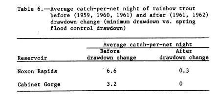
5 Fish Population Trends Gill net catches from 1955 on both reservoirs indicate extremely low numbers of game fish except during 1960 (table 4). Results are expressed using an average catch-per-net night based on a 125-foot net. Rainbow trout caught during 1960 were a direct result from large plants made 1 and 2 years earlier. Subsequent rainbow plants made in and 1981 never contributed significantly to gill net catches. Other game fish found in the reservoirs (bull trout, brown trout, white- fish, and bass) fluctuated moderately during the period with no obvious trends. Whitefish were caught in greater numbers than any other game fish during all years except for during 1960 in Cabinet Gorge when the average rainbow catch was 8.9 fish per net night. The number of suckers in both reservoirs has decreased substantially during the netting period. Chemical treatment in 1958 may have temporarily decreased suckers in Cabinet Gorge, but had little effect on Noxon Rapids' populations. Northern squawfish numbers dropped slightly during the early portion of the period and now appear to be increasing. Peamouth and yellow perch have steadily increased. Small mouth bass planted in 1982 and 1983 in Noxon Rapids appear to be spreading throughout the reservoir in good numbers from 1983 to 1984 surveys (fig. 5). Scale aging showed the majority of fish resulting from the 1982 plant averaged 6.9 inches in June and 8.2 inches in August. Small mouth bass were not located in Cabinet Gorge during 1984 sampling, suggesting downstream movement was not extensive. Largemouth bass appear to be increasing in both reservoirs since flow stabilization in 1978 (figs. 5 and 6). Gill netting is not an efficient method to capture largemouth; however, they were observed and caught by fishing and observed during snorkeling. Increased growth of aquatic vegetation, particularly in Noxon Rapids, appears to be providing more suitable habitat for largemouth bass. Redside shiners, a prey species for both largemouth and small mouth bass, also prefer and benefit from this type of habitat. Ling have not been caught during sampling since introduction in 1971, but three were reported caught by anglers. Creel Census Information compiled from anglers is similar to the results from gill netting on both reservoirs when considering game fish (table 5). An elaborate creel census was conducted from 1959 to 1962 when large numbers of rainbow trout were tagged and released. Fingerling rainbow primarily entered the catch 2 years after stocking, and this occurred during 1960 and During 1962, catches were primarily 3- and 4-year-old fish, indicating poor survival on the later plants. Fish marking was conducted from 1958 until 1962 in Noxon Rapids and from 1959 until 1961 in Cabinet Gorge Reservoir. This effort was directed toward rainbow trout and was used to determine fish movement. Returns from gill net catches and anglers demonstrated that rainbow trout, with few exceptions, moved downstream. Downstream movement in both reservoirs was also found through gill netting in the spring of 1961 when operations changed from a limited daily drawdown of 1-2 feet to an annual spring flood control drawdown of approximately 35 feet (table 6). There was a considerable
6 decrease in the number of rainbow trout taken from gill nets after drawdown, whereas other fish were not greatly affected. Age and Growth Scales for age and growth determination were collected from gill netting and creel census from 1958 to 1961 and 1966 to 1976 from Noxon Rapids (table 7). Data listed represent back-calculated annulus growth increments in inches from fish before and after the drawdown change. Growth rates for Noxon Rapids' rainbow were slow before the drawdown change in comparison to other Montana reservoirs. Sample sizes for rainbow were inadequate, and no conclusions were drawn from after the drawdown change. Growth for bull and brown trout was better after the drawdown change and probably resulted from an increased forage base in the reservoir. Growth rates for largemouth bass inhabiting Noxon Rapids Reservoir were slow when compared with other reservoirs. Fish reach a catchable size of 10 inches at the start of their fifth year of life. Reservoir Limnology Neither Noxon Rapids nor Cabinet Gorge Reservoirs forms an abrupt thermo-cline. Surface temperatures during July seldom rise above 74 of and average 72 of except for the shallow littoral areas. Temperatures 100 feet deep average 65 of, while those at 175 feet were about 55 of. Dissolved oxygen concentrations ranged between 7.5 and 9.0 ppm at the surface, and never fell below 5.0 ppm at the 175-foot. level. Temperature and oxygen levels in the deeper areas are within the range of game fish tolerance during the warm months. Complete ice cover on Noxon Rapids Reservoir occurs from 2 to 3 months during a typical year, where Cabinet Gorge Reservoir rarely exceeds per' cent cover for 1-2 months. Productivity within both reservoirs is expected to be limited due to the rapid exchange rates. Reservoir drawdowns further reduce production and disrupt food chains due to the variations in habitat. Gas saturation levels were determined for water entering and leaving Thompson Falls Dam, Noxon Rapids Dam, and Cabinet Gorge Dam in The Thompson Falls forebay averaged about 100 percent from April through August. During spill discharge, each dam added about 10 percent to gas saturation levels. No equilibrium of supersaturated water occurred in Noxon Rapids, Cabinet Gorge, or the Clark Fork River downstream. Fish bore few scars symptomatic of gas bubble disease; however, the effects of super saturation on bio- logical communities were not determined. Conclusion Development and maintenance of a sport fishery in these two run-of-the- river reservoirs has not been successful. Downstream movement by rainbow trout has been attributed to changing flow regimes, rapid exchange rates, and limited productivity.
7 Plan for Future Management Cooperation with Washington Water Power Company has established more stable reservoir levels in recent years (1978-present). Under this reservoir-level regime, species showing past success will receive the greatest management emphasis as well as fish with potential in similar reservoir situations. These will include small mouth and largemouth bass, ling, brown and bull trout, kamloops, and the McCounaghy strain of rainbow trout that have proven successful in other fluctuating reservoirs. Bass management for 1985 includes planting 100,000 small mouth in Noxon Rapids Reservoir. Ling will be collected from the Kootenai River and reintroduced during Brown trout eggs are scheduled to be taken from Willow Creek Reservoir in the fall of Eggs and fry will be imprinted into Noxon Rapids Reservoir tributaries in the spring of Bull trout will also be planted when an egg source becomes available. Kamloops rainbow are also scheduled for planting in Follow up surveys will be necessary to determine success of the above introductions. Changes and development within the Clark Fork drainage will also warrant future investigation. Literature Cited 1. Gaffney, A survey of the fishery resources in a section of the Clark Fork River in western Montana. Progress report, Project 29-E-1, Mont. Fish & Game, Helena, MT. 12 p., mimeo. 2. Gaffney, J.J Partial rehabilitation of a section of the Clark Fork River. Progress report, Project 29-E-1, Mont. Fish & Game, Helena, MT. 19 p., mimeo. 3. Huston, J.E Investigation of two Clark Fork River hydroelectric impoundments. Proc. Mon~. Acad. Sci., 25: Huston, J.E Noxon Rapids and Cabinet Gorge Reservoirs study. Fed. Aid Project F-34- R-l through 16, Job 1, Mont. Dept Fish, Wildlife and Parks. Mimeo reports. 5. Huston. J.E.; and Vaughn. T Temporal movement of rainbow trout in reservoirs. Proc. West. Assoc. State Game and Fish Comm.. Reno, NV. 6. Pfeiffer, D.E Studies of Micropterus species in two Clark Fork River hydroelectric impoundments in western Montana. Washington Water Power Co., Spokane, WA.
8
9
10
11
12
13
14
15

16
NEVADA DEPARTMENT OF WILDLIFE STATEWIDE FISHERIES MANAGEMENT
 NEVADA DEPARTMENT OF WILDLIFE STATEWIDE FISHERIES MANAGEMENT FEDERAL AID JOB PROGRESS REPORTS F-20-48 2012 LAKE TAHOE WESTERN REGION Contents NEVADA DEPARTMENT OF WILDLIFE, FISHERIES DIVISION ANNUAL PROGRESS
LAKE TANEYCOMO 2011 ANNUAL LAKE REPORT
 LAKE TANEYCOMO 211 ANNUAL LAKE REPORT Shane Bush Fisheries Management Biologist Missouri Department of Conservation Southwest Region March 1, 212 EXECUTIVE SUMMARY Lake Taneycomo was formed by the construction
SKIATOOK LAKE MANAGEMENT PLAN
 SKIATOOK LAKE MANAGEMENT PLAN Background Skiatook Lake impounds Hominy Creek, 5 miles west of Skiatook in Osage County, Oklahoma (Figure 1). Skiatook Lake covers 10,540 surface acres and was constructed
NEVADA DEPARTMENT OF WILDLIFE STATEWIDE FISHERIES MANAGEMENT
 NEVADA DEPARTMENT OF WILDLIFE STATEWIDE FISHERIES MANAGEMENT FEDERAL AID JOB PROGRESS REPORTS F-20-49 2013 SQUAW CREEK RESERVOIR WESTERN REGION Contents NEVADA DEPARTMENT OF WILDLIFE, FISHERIES DIVISION
Striped Bass and White Hybrid (x) Striped Bass Management and Fishing in Pennsylvania
 Striped Bass Management and Fishing in Pennsylvania") Striped Bass and White Hybrid (x) Striped Bass Management and Fishing in Pennsylvania Prepared by R. Lorantas, D. Kristine and C. Hobbs PFBC Warmwater Unit 2005 (stocking numbers updated after 2005) Goal:
Striped Bass and White Hybrid (x) Striped Bass Management and Fishing in Pennsylvania Prepared by R. Lorantas, D. Kristine and C. Hobbs PFBC Warmwater Unit 2005 (stocking numbers updated after 2005) Goal:
Quemahoning Reservoir
 Pennsylvania Fish & Boat Commission Biologist Report Quemahoning Reservoir Somerset County May 2011 Trap Net, Gill Net and Electrofishing Survey Quemahoning Reservoir is an 899 acre impoundment located
NEVADA DEPARTMENT OF WILDLIFE STATEWIDE FISHERIES MANAGEMENT
 NEVADA DEPARTMENT OF WILDLIFE STATEWIDE FISHERIES MANAGEMENT FEDERAL AID JOB PROGRESS REPORTS F-20-52 2016 Lake Tahoe Rainbow Trout Study WESTERN REGION NEVADA DEPARTMENT OF WILDLIFE, FISHERIES DIVISION
Michigan Dept. of Natural Resources Status of the Fishery Resource Report Page 1. Weber Lake Cheboygan County, T34N, R3W, Sec.
 Michigan Dept. of Natural Resources 2012-143 Status of the Fishery Resource Report Page 1 Weber Lake Cheboygan County, T34N, R3W, Sec. 31 Neal Godby, Fisheries Biologist Environment Weber Lake is a 28.5-acre
Abundance of Steelhead and Coho Salmon in the Lagunitas Creek Drainage, Marin County, California
 scanned for KRIS Abundance of Steelhead and Coho Salmon in the Lagunitas Creek Drainage, Marin County, California Prepared for: Marin Municipal Water District 220 Nellen Drive Corte Madera, California
CARL BLACKWELL LAKE MANAGEMENT PLAN
 CARL BLACKWELL LAKE MANAGEMENT PLAN Background Lake Carl Blackwell impounds Stillwater Creek, 10 miles west of Stillwater in Payne County, Oklahoma (Figure 1). The lake covers 3,370 surface acres and was
LAKE DIANE Hillsdale County (T8-9S, R3W, Sections 34, 3, 4) Surveyed May Jeffrey J. Braunscheidel
 Surveyed May Jeffrey J. Braunscheidel") Michigan Department of Natural Resources Status of the Fishery Resource Report No. 2003-4, 2003 LAKE DIANE Hillsdale County (T8-9S, R3W, Sections 34, 3, 4) Surveyed May 2001 Jeffrey J. Braunscheidel Environment
Michigan Department of Natural Resources Status of the Fishery Resource Report No. 2003-4, 2003 LAKE DIANE Hillsdale County (T8-9S, R3W, Sections 34, 3, 4) Surveyed May 2001 Jeffrey J. Braunscheidel Environment
Upper/Lower Owl Creek Reservoir
 Upper/Lower Owl Creek Reservoir Schuylkill County 2018 Largemouth Bass Survey Upper Owl Creek Reservoir and Lower Owl Creek Reservoir are 67-acre and 26-acre impoundments, respectively, created by two
Justification for Rainbow Trout stocking reduction in Lake Taneycomo. Shane Bush Fisheries Management Biologist Missouri Department of Conservation
 Justification for Rainbow Trout stocking reduction in Lake Taneycomo Shane Bush Fisheries Management Biologist Missouri Department of Conservation December 14, 2017 Lake Taneycomo was formed by the construction
Stony Creek Creel Census
 Stony Creek Creel Census conducted for Division of Fisheries Illinois Department of Conservation 600 North Grand Ave. West Springfield, IL 62706 by R. Weldon Larimore, Principal Investigator Jack A. Swanson,
Study Update Fish Distribution and Species Composition
 Study Update Fish Distribution and Species Composition Goals and Study Area Gain a better understanding of fish species composition and abundance in waters associated with the Packwood Lake Hydroelectric
MIDDLE FORK RESERVOIR Wayne County 2004 Fish Management Report. Christopher C. Long Assistant Fisheries Biologist
 MIDDLE FORK RESERVOIR Wayne County 2004 Fish Management Report Christopher C. Long Assistant Fisheries Biologist FISHERIES SECTION INDIANA DEPARTMENT OF NATURAL RESOURCES DIVISION OF FISH AND WILDLIFE
NEVADA DEPARTMENT OF WILDLIFE STATEWIDE FISHERIES MANAGEMENT
 NEVADA DEPARTMENT OF WILDLIFE STATEWIDE FISHERIES MANAGEMENT FEDERAL AID JOB PROGRESS REPORTS F-2-52 216 CHIMNEY RESERVOIR WESTERN REGION NEVADA DEPARTMENT OF WILDLIFE, FISHERIES DIVISION JOB PROGRESS
NEVADA DEPARTMENT OF WILDLIFE STATEWIDE FISHERIES MANAGEMENT
 NEVADA DEPARTMENT OF WILDLIFE STATEWIDE FISHERIES MANAGEMENT FEDERAL AID JOB PROGRESS REPORTS F-20-52 2016 LAKE TAHOE WESTERN REGION NEVADA DEPARTMENT OF WILDLIFE, FISHERIES DIVISION ANNUAL PROGRESS REPORT
Flowering Rush An Invasive Aquatic Macrophyte Infesting the Columbia River Basin
 Flowering Rush An Invasive Aquatic Macrophyte Infesting the Columbia River Basin Virgil Dupuis Salish Kootenai College Peter Rice University of Montana Pacific Northwest Distribution Montana Distribution
LAKE TANEYCOMO 2012 ANNUAL LAKE REPORT. Shane Bush Fisheries Management Biologist Missouri Department of Conservation Southwest Region
 LAKE TANEYCOMO 12 ANNUAL LAKE REPORT Shane Bush Fisheries Management Biologist Missouri Department of Conservation Southwest Region March 1, 13 EXECUTIVE SUMMARY Lake Taneycomo was formed by the construction
Big Spring Creek Habitat Enhancement and Fishery Management Plans
 Big Spring Creek Habitat Enhancement and Fishery Management Plans November 5, 2012 Big Spring Events and Activities Center Newville, PA Charlie McGarrell Regional Habitat Biologist Pennsylvania Fish and
Elk Lake, Antrim and Grand Traverse counties T. 28, 29 N., R. 8, 9 W., Sec. many. Lake surveys. began at 40 feet
 Elk Lake, Antrim and Grand Traverse counties T. 28, 29 N., R. 8, 9 W., Sec. many Physical and chemical data surveyed August 1931 Temperature ( F) Secchi disk (feet) 9. 6 Surface 74 Bottom 45 PH 8.0 Thermocline
FINAL Caples Lake Fisheries Management Plan. Version 4.0
 FINAL Caples Lake Fisheries Management Plan Version 4.0 August 15, 2008 Purpose The Caples Lake Fisheries Management Plan (Plan) outlines the stocking plan to reestablish a sport fishery in Caples Lake
NEVADA DEPARTMENT OF WILDLIFE STATEWIDE SPORT FISHERIES MANAGEMENT
 NEVADA DEPARTMENT OF WILDLIFE STATEWIDE SPORT FISHERIES MANAGEMENT FEDERAL AID JOB PROGRESS REPORT F-2-52 216 WILDHORSE RESERVOIR EASTERN REGION NEVADA DEPARTMENT OF WILDLIFE, FISHERIES DIVISION ANNUAL
Columbia Lake Dam Removal Project
 Columbia Lake Dam Removal Project The Columbia Lake dam located 1/4 mile upstream of the Paulins Kill River's confluence with the Delaware River in Knowlton Township, Warren County has been proposed for
Caro Impoundment, Tuscola County
 Caro Impoundment is a 200 acre impoundment of the Cass River located one mile south of the Village of Caro in Tuscola County. Caro Dam, originally constructed in 1906 for water supply to Michigan Sugar
6TH PELLETIER BROOK LAKE T15 R9, Aroostook Co. U.S.G.S. Gardner Pond, Maine (7 1/2 )
") 6TH PELLETIER BROOK LAKE T15 R9, Aroostook Co. U.S.G.S. Gardner Pond, Maine (7 1/2 ) Fishes Brook trout Minnows Blacknose dace Pearl dace Physical Characteristics Area - 27 acres Average depth - 2 feet
6TH PELLETIER BROOK LAKE T15 R9, Aroostook Co. U.S.G.S. Gardner Pond, Maine (7 1/2 ) Fishes Brook trout Minnows Blacknose dace Pearl dace Physical Characteristics Area - 27 acres Average depth - 2 feet
SOONER LAKE MANAGEMENT PLAN
 SOONER LAKE MANAGEMENT PLAN Background Lake Sooner impounds Greasy Creek, 15 miles south of Ponca City in Noble and Pawnee Counties, Oklahoma (Figure 1). The Grease Creek basin that Sooner Lake impounds
Cedar Lake Comprehensive Survey Report Steve Hogler and Steve Surendonk WDNR-Mishicot
 Cedar Lake- 2006 Comprehensive Survey Report Steve Hogler and Steve Surendonk WDNR-Mishicot ABSTRACT Cedar Lake is a 142 acre lake located in the southwest corner of Manitowoc County. It is a seepage lake
Rehabilitation of Grimes Creek, a Stream Impacted in the Past by Bucket-lined Dredge Gold Mining, Boise River Drainage, July 2008 to August 2011.
 Rehabilitation of Grimes Creek, a Stream Impacted in the Past by Bucket-lined Dredge Gold Mining, Boise River Drainage, July 2008 to August 2011. Pam Harrington TU,1020 W. Main Street Suite 440, Boise,
JadEco, LLC PO BOX 445 Shannon, IL 61078
 Introduction: With the assistance of Lake Holiday staff and volunteers, we were able to conduct an AC electrofishing survey on May 8, 27. Water temperatures were 2.3 C (8.5 F) and water clarity was decent
Current Status and Management Recommendations for the Fishery in the Cloverleaf Chain of Lakes
 Current Status and Management Recommendations for the Fishery in the Cloverleaf Chain of Lakes Jason Breeggemann Senior Fisheries Biologist Wisconsin Department of Natural Resources Outline DNR fisheries
NEVADA DEPARTMENT OF WILDLIFE STATEWIDE FISHERIES MANAGEMENT
 NEVADA DEPARTMENT OF WILDLIFE STATEWIDE FISHERIES MANAGEMENT FEDERAL AID JOB PROGRESS REPORTS F-20-52 2016 REDBAND TROUT EASTERN REGION NEVADA DEPARTMENT OF WILDLIFE, FISHERIES DIVISION ANNUAL JOB PROGRESS
BIG TWIN LAKE Kalkaska County (T28N, R05W, Section 18, and T28N, R06W, Section 13) Surveyed May 1999
 Surveyed May 1999") Michigan Department of Natural Resources Status of the Fishery Resource Report No. 2001-1, Year 2001 BIG TWIN LAKE Kalkaska County (T28N, R05W, Section 18, and T28N, R06W, Section 13) Surveyed May 1999
Michigan Department of Natural Resources Status of the Fishery Resource Report No. 2001-1, Year 2001 BIG TWIN LAKE Kalkaska County (T28N, R05W, Section 18, and T28N, R06W, Section 13) Surveyed May 1999
NEVADA DEPARTMENT OF WILDLIFE STATEWIDE FISHERIES MANAGEMENT
 NEVADA DEPARTMENT OF WILDLIFE STATEWIDE FISHERIES MANAGEMENT FEDERAL AID JOB PROGRESS REPORTS F-20-49 2013 LAKE TAHOE WESTERN REGION NEVADA DEPARTMENT OF WILDLIFE, FISHERIES DIVISION ANNUAL PROGRESS REPORT
Lake Chelan Kokanee Spawning Ground Surveys 2012 Final Report
 Lake Chelan Kokanee Spawning Ground Surveys 2012 Final Report Spawning kokanee (Oncorhynchus nerka) in Company Creek Chelan County PUD, 2005. (Photo by Brad Buchsieb) Prepared by: Barry G. Keesee And Lance
5B. Management of invasive species in the Cosumnes and Mokelumne River Basins
 5B. Management of invasive species in the Cosumnes and Mokelumne River Basins Cosumnes River The Cosumnes River basin has a number of distinct habitat types that require different management strategies
Michigan Department of Natural Resources Status of the Fishery Resource Report Page 1
 Michigan Department of Natural Resources 2007-33 Status of the Fishery Resource Report Page 1 Grand Sable Lake Alger County, T49N, R14W, Sec. Many Lake Superior watershed, last year surveyed 2004 James
Dauphin Lake Fishery. Status of Walleye Stocks and Conservation Measures
 Dauphin Lake Fishery Status of Walleye Stocks and Conservation Measures Date: December, 21 Dauphin Lake Fishery Status of Walleye Stocks and Conservation Measures Background: Walleye stocks in Dauphin
WFC 50 California s Wild Vertebrates Jan. 11, Inland Waters (Lakes and Streams) Lisa Thompson
 Lisa Thompson") Inland Waters: Lakes and Streams WFC 50 11 January 2011 Lisa Thompson Fisheries Extension Specialist Wildlife, Fish, & Conservation Biology Department University of California, Davis Take home messages
Inland Waters: Lakes and Streams WFC 50 11 January 2011 Lisa Thompson Fisheries Extension Specialist Wildlife, Fish, & Conservation Biology Department University of California, Davis Take home messages
Chadbourne Dam Repair and Fish Barrier
 Chadbourne Dam Repair and Fish Barrier Final Report for the Western Native Trout Initiative Prepared by: Carol Endicott Yellowstone Cutthroat Trout Conservation Biologist Montana Fish, Wildlife & Parks
Okanagan Sockeye Reintroduction
 Okanagan Sockeye Reintroduction Backgrounder Elders accounts, and other forms of Traditional Ecological Knowledge (TEK) tell us that many species of salmon once came into the Okanagan Valley and tell us
Minnesota Department of Natural Resources Division of Fish and Wildlife Section of Fisheries. Stream Survey Report. Luxemburg Creek.
 Minnesota F-29-R(P)-24 Area 315 Study 3 March 2016 Minnesota Department of Natural Resources Division of Fish and Wildlife Section of Fisheries Stream Survey Report Luxemburg Creek 2015 Mark Pelham Sauk
Monitoring of Downstream Fish Passage at Cougar Dam in the South Fork McKenzie River, Oregon February 8, By Greg A.
 Monitoring of Downstream Fish Passage at Cougar Dam in the South Fork McKenzie River, Oregon 1998- February 8, 2 By Greg A. Taylor Oregon Dept. of Fish & Wildlife 315 E. Main Street Springfield, OR 97478
NEVADA DEPARTMENT OF WILDLIFE STATEWIDE FISHERIES MANAGEMENT FEDERAL AID JOB PROGRESS REPORTS F EUREKA COUNTY Small Lakes and Reservoirs
 NEVADA DEPARTMENT OF WILDLIFE STATEWIDE FISHERIES MANAGEMENT FEDERAL AID JOB PROGRESS REPORTS F-20-48 2012 EUREKA COUNTY Small Lakes and Reservoirs NEVADA DEPARTMENT OF WILDLIFE, FISHERIES DIVISION ANNUAL
Study Update Tailrace Slough Use by Anadromous Salmonids
 Study Update Tailrace Slough Use by Anadromous Salmonids Goals and Objectives Identify what anadromous salmonids use the tailrace slough by: Life Stage (Juvenile, migrating and spawning adults) Timing
Arizona Game and Fish Department Region I Fisheries Program. Chevelon Canyon Lake Fish Survey Report Trip Report April 2015
 Arizona Game and Fish Department Region I Fisheries Program Chevelon Canyon Lake Fish Survey Report Trip Report April 2015 Authors: Sally Petre and Mike Lopez Report Date: June 25, 2015 The Arizona Game
HUBBARD LAKE Alcona County (T27N, R7E; T28N, R7E) Surveyed May and September Tim A. Cwalinski
 Surveyed May and September Tim A. Cwalinski") Michigan Department of Natural Resources Status of the Fishery Resource Report No. 2003-1, 2003 HUBBARD LAKE Alcona County (T27N, R7E; T28N, R7E) Surveyed May and September 1996 Tim A. Cwalinski Environment
Michigan Department of Natural Resources Status of the Fishery Resource Report No. 2003-1, 2003 HUBBARD LAKE Alcona County (T27N, R7E; T28N, R7E) Surveyed May and September 1996 Tim A. Cwalinski Environment
Alcona Dam Pond Alcona County (T25N, R5E, Sections various) Surveyed June 6-12 and September 16, 2003
 Surveyed June 6-12 and September 16, 2003") Michigan Department of Natural Resources Status of the Fishery Resource Report No. 2004-6, Year 2004 Alcona Dam Pond Alcona County (T25N, R5E, Sections various) Surveyed June 6-12 and September 16, 2003
Michigan Department of Natural Resources Status of the Fishery Resource Report No. 2004-6, Year 2004 Alcona Dam Pond Alcona County (T25N, R5E, Sections various) Surveyed June 6-12 and September 16, 2003
Management Plan for the Obey River Trout Fishery
 Management Plan for the Obey River Trout Fishery 28-214 By: James Travis Scott Jack Swearengin Walter Scott Webb D.W. Young Tennessee Wildlife Resources Agency January 28 Management Plan for the Obey River
Don Pedro Project Relicensing
 Don Pedro Project Relicensing M ODESTO I RRIGATION D ISTRICT TURLOCK I RRIGATION D ISTRICT FERC PROJECT N O. 2299 Resident Fish in Don Pedro Reservoir Don Pedro Reservoir Fish Stocking (1971-Present) CDFG
1 INTRODUCTION AND SUMMARY
 December 10, 2012 Pacific Booker Minerals 1702 1166 Alberni Street Vancouver, British Columbia V6E 3Z3 Erik Tornquist Executive VP and COO Dear Mr. Erik Tornquist: 1 INTRODUCTION AND SUMMARY This letter
NEVADA DEPARTMENT OF WILDLIFE STATEWIDE FISHERIES MANAGEMENT
 NEVADA DEPARTMENT OF WILDLIFE STATEWIDE FISHERIES MANAGEMENT FEDERAL AID JOB PROGRESS REPORTS F-20-52 2016 BOULDER RESERVOIR WESTERN REGION NEVADA DEPARTMENT OF WILDLIFE, FISHERIES DIVISION ANNUAL PROGRESS
OKANAGAN LAKE FISH MANAGEMENT PLAN SUMMARY
 lin,'roduction 1990-1995 OKANAGAN LAKE FISH MANAGEMENT PLAN SUMMARY B.C. Environment's Fisheries Branch looks after the province's freshwater fish. In Okanagan Lake, game fish inventories reveal an alarming
Fish Habitat Restoration and Monitoring in Southeast Washington. Andy Hill Eco Logical Research, Inc.
 Fish Habitat Restoration and Monitoring in Southeast Washington Andy Hill Eco Logical Research, Inc. Fish Habitat Restoration and Monitoring in Southeast Washington Talk overview: Restoration projects
Regulations. Grabbling season May 1 July 15; only wooden structures allowed.
 Arkabutla Reservoir 219 REEL FACTS Keith Meals, Arthur Dunn, Stanley Turner Fisheries Biologists keithm@wfp.ms.gov, ArthurD@wfp.ms.gov, StanleyT@wfp.ms.gov General Information: Arkabutla Reservoir is one
OREGON DEPARTMENT OF FISH AND WILDLIFE ROGUE FISH DISTRICT REPORT
 OREGON DEPARTMENT OF FISH AND WILDLIFE ROGUE FISH DISTRICT REPORT TITLE: Upper Rogue Smolt Trapping Project, 1999 STREAM: Big Butte, Little Butte, South Fork Big Butte, Slate and West Fork Evans Creeks
MARTINDALE POND Wayne County 2004 Fish Management Report. Christopher C. Long Assistant Fisheries Biologist
 MARTINDALE POND Wayne County 2004 Fish Management Report Christopher C. Long Assistant Fisheries Biologist Fisheries Section Indiana Department of Natural Resources Division of Fish and Wildlife I.G.C.
Ecology and control of invasive Northern Pike in the Columbia River, Canada
 Ecology and control of invasive Northern Pike in the Columbia River, Canada Brian Heise, Daniel Doutaz, Matthias Herborg, Matt Neufeld, David Derosa, Jeremy Baxter 19 th International Conference on Aquatic
Redd Dewatering and Juvenile Salmonid Stranding in the Lower Feather River,
 Redd Dewatering and Juvenile Salmonid Stranding in the Lower Feather River, 2005-2006 Interim Report for NOAA Fisheries Prepared by: California Department of Water Resources Division of Environmental Services
2013 Electrofishing Program Summary. Miramichi Salmon Association In collaboration with the Department of Fisheries and Oceans
 2013 Electrofishing Program Summary Miramichi Salmon Association In collaboration with the Department of Fisheries and Oceans Prepared by: Alex Parker Biologist Miramichi Salmon Association 485, Route
Sebec Lake Fisheries Management Plan 2012
 Sebec Lake Fisheries Management Plan 2012 Sebec Lake is a 6,800-acre oligotrophic lake located in northwestern Maine. It has popular fisheries for landlocked salmon, lake trout, and smallmouth bass. Other
LAKE TANEYCOMO ANGLER CREEL SURVEY SUMMARY. Shane Bush Fisheries Management Biologist Missouri Department of Conservation Southwest Region
 LAKE TANEYCOMO 2008-2009 ANGLER CREEL SURVEY SUMMARY Shane Bush Fisheries Management Biologist Missouri Department of Conservation Southwest Region February 1, 2013 Introduction Lake Taneycomo was formed
Yakima/Klickitat Fisheries Project
 Yakima/Klickitat Fisheries Project Lower Yakima River Supplementation and Research Project Operations and Maintenance Annual Report 2002-2003 March 2004 DOE/BP-00006677-1 This Document should be cited
Big Canyon 67 miles upstream. 38 miles upstream
 TEXOMA STRIPED BASS MANAGEMENT/RESEARCH Texoma is one of only about 1 reservoirs in the country that has a naturally reproducing striped bass population. Texoma is set off further from most reservoirs
FISH COMMUNITIES AND FISHERIES OF THE THOUSAND ISLANDS AND MIDDLE CORRIDOR
 St. Lawrence River Discussion Paper FISH COMMUNITIES AND FISHERIES OF THE THOUSAND ISLANDS AND MIDDLE CORRIDOR Issues Below is a synopsis of fish community issues and proposed management approaches. More
The Fishery. Newfoundland Region Stock Status Report D2-05
 Fisheries Pêches and Oceans et Océans DFO Science Newfoundland Region Stock Status Report D2-05 ATLANTIC SALMON INSULAR NEWFOUNDLAND, SOUTHWEST COAST, SALMON FISHING AREAS 12-13 Background Salmon Fishing
MINISTRY OF ENVIRONMENT ENVIRONMENTAL STEWARDSHIP DIVISION FISH AND WILDLIFE BRANCH. Horsefly River Angling Management Plan
 MINISTRY OF ENVIRONMENT ENVIRONMENTAL STEWARDSHIP DIVISION FISH AND WILDLIFE BRANCH Horsefly River Angling Management Plan January 30 th, 2006 Area/Fishery Description The Horsefly River watershed provides
NEVADA DEPARTMENT OF WILDLIFE STATEWIDE FISHERIES MANAGEMENT
 NEVADA DEPARTMENT OF WILDLIFE STATEWIDE FISHERIES MANAGEMENT FEDERAL AID JOB PROGRESS REPORTS F-20-48 2012 RYE PATCH RESERVOIR WESTERN REGION NEVADA DEPARTMENT OF WILDLIFE, FISHERIES DIVISION JOB PROGRESS
LIFE HISTORY DIVERSITY AND RESILIENCE
 LIFE HISTORY DIVERSITY AND RESILIENCE SPRING CHINOOK IN THE WILLAMETTE RIVER BASIN Kirk Schroeder Brian Cannon Luke Whitman Paul Olmsted Oregon Department of Fish and Wildlife Corvallis Research Lab Thanks
Crooked Lake Oakland County (T4N, R9E, Sections 3, 4, 9) Surveyed May James T. Francis
 Surveyed May James T. Francis") Michigan Department of Natural Resources Status of the Fishery Resource Report No. 2004-1, 2004 Crooked Lake Oakland County (T4N, R9E, Sections 3, 4, 9) Surveyed May 2002 James T. Francis Environment Crooked
Michigan Department of Natural Resources Status of the Fishery Resource Report No. 2004-1, 2004 Crooked Lake Oakland County (T4N, R9E, Sections 3, 4, 9) Surveyed May 2002 James T. Francis Environment Crooked
Trip Report: Eagle Creek, Arizona
 Trip Report: Eagle Creek, Arizona 15-17 June 2009 Participants: Abraham Karam, Brian Kesner, and Mike Childs Native Fish Lab Marsh & Associates, LLC 5016 South Ash Avenue Suite 108 Tempe, Arizona 85282
STEELHEAD SURVEYS IN OMAK CREEK
 STEELHEAD SURVEYS IN OMAK CREEK 2002 Annual Report Prepared by Chris Fisher John Arterburn Colville Confederated Tribes Fish and Wildlife Department P.O. Box 150 Nespelem, WA 99155 Prepared for Project
DRIPPING SPRINGS LAKE 5 YEAR LAKE MANAGEMENT PLAN
 DRIPPING SPRINGS LAKE 5 YEAR LAKE MANAGEMENT PLAN FISHERIES DIVISION CENTRAL REGION OKLAHOMA DEPTMENT OF WILDLIFE CONSERVATION PREPARED BY: DANNY BOWEN OCTOBER 2013 1 Background Dripping Springs Lake impounds
NEVADA DEPARTMENT OF WILDLIFE STATEWIDE FISHERIES MANAGEMENT
 NEVADA DEPARTMENT OF WILDLIFE STATEWIDE FISHERIES MANAGEMENT FEDERAL AID JOB PROGRESS REPORTS F-2-49 213 RYE PATCH RESERVOIR WESTERN REGION NEVADA DEPARTMENT OF WILDLIFE, FISHERIES DIVISION ANNUAL PROGRESS
Job Performance Report, Project F-73-R-9 Subproject II: SALMON AND STEELHEAD INVESTIGATIONS Study I: Salmon Spawning Ground Surveys
 FEDERAL AID IN FISH RESTORATION Job Performance Report, Project F-73-R-9 Subproject II: SALMON AND STEELHEAD INVESTIGATIONS Study I: Salmon Spawning Ground Surveys By Judy Hall-Griswold, Fishery Technician
FISHERIES BLUE MOUNTAINS ADAPTATION PARTNERSHIP
 FISHERIES A warming climate, by itself, substantially affects the hydrology of watersheds in the Blue Mountains. Among the key hydrologic changes projected under all scenarios for the 2040s and beyond
CUSHMAN RESERVOIRS. Skokomish Watershed Monitoring Conference - Public Meeting Florian Leischner 9/17/2015
 CUSHMAN RESERVOIRS Skokomish Watershed Monitoring Conference - Public Meeting Florian Leischner 9/17/2015 CUSHMAN RESERVOIRS MONITORING Management and monitoring of Tacoma Power reservoirs Lake Cushman
LOGAN MARTIN RESERVOIR MANAGEMENT REPORT. Prepared by. E. Daniel Catchings District Fisheries Supervisor
 LOGAN MARTIN RESERVOIR MANAGEMENT REPORT 2008 Prepared by E. Daniel Catchings District Fisheries Supervisor Robert O. Andress District Fisheries Biologist Department of Conservation and Natural Resources
SALMON FACTS. Chinook Salmon. Oncorhynchus tshawytscha
 SALMON FACTS Chinook Salmon Oncorhynchus tshawytscha Other names: king, tyee, blackmouth (immature) Average size: 10-15 lbs, up to 135 lbs Fall spawner; fall, spring, and summer runs Chinook salmon are
Regulations. Grabbling season May 1 July 15; only wooden structures allowed.
 Enid Reservoir 218 REEL FACTS Keith Meals, Arthur Dunn, Stanley Turner Fisheries Biologists keithm@mdwfp.state.ms.us, ArthurD@mdwfp.state.ms.us, StanleyT@mdwfp.state.ms.us General Information: Enid Reservoir
NEVADA DEPARTMENT OF WILDLIFE STATEWIDE FISHERIES MANAGEMENT
 NEVADA DEPARTMENT OF WILDLIFE STATEWIDE FISHERIES MANAGEMENT FEDERAL AID JOB PROGRESS REPORTS F-20-50 2014 BILK CREEK RESERVOIR WESTERN REGION 1 NEVADA DEPARTMENT OF WILDLIFE, FISHERIES DIVISION JOB PROGRESS
NATIVE FISH CONSERVATION PLAN FOR THE SPRING CHINOOK SALMON ROGUE SPECIES MANAGEMENT UNIT
 Attachment 4 NATIVE FISH CONSERVATION PLAN FOR THE SPRING CHINOOK SALMON ROGUE SPECIES MANAGEMENT UNIT Figures in Draft Plan of February 28, 27 Figure 1. Map of the Rogue River Basin. PASSAGE ESTIMATES
Yakima River Basin Coho Reintroduction Feasibility Study
 Yakima River Basin Coho Reintroduction Feasibility Study Yakima Klickitat Fisheries Project Goals and Mission The purposes of the YKFP are to: enhance existing stocks of anadromous fish in the Yakima and
Lower Dolores River Corridor Planning Meeting Jim White Colorado Division of Wildlife
 Lower Dolores River Corridor Planning Meeting Jim White Colorado Division of Wildlife Objectives Overview of cold and warm water fishes in the Dolores River including: Flow and Fish Management Distribution
Alberta Conservation Association 2009/10 Project Summary Report. Project Name: North Saskatchewan and Ram Rivers Bull Trout Spawning Stock Assessment
 Alberta Conservation Association 2009/10 Project Summary Report Project Name: North Saskatchewan and Ram Rivers Bull Trout Spawning Stock Assessment Fisheries Program Manager: Peter Aku Project Leader:
I Region I Area I DOW Number / County I DOW Lake Name I Acreage I
 LAKE MANAGEMENT PLAN 814 Bp I Region I Area I DOW Number / County I DOW Lake Name I Acreage I I I # I f 2 Duluth F213 690036 St Louis Salo DOW:149 Plan: 137 Long Range Goal: Manage for walleye with a gillnet
Appendix A Recommended EPA Temperature Thresholds for use in Establishing Thermal Potential and Species Life Stage Numeric Criteria
 Appendix A Recommended EPA Temperature Thresholds for use in Establishing Thermal Potential and Species Life Stage Numeric Criteria 1. Temperature Limits Recommended to Protect Salmonid Guilds In this
Fish Community. Fish Habitat, Streams and Rivers
 Clear, Ston(e)y and White Lake Plan Fish Community The lakes support a cool/warm water fishery including muskellunge, walleye, largemouth and smallmouth bass, yellow perch, pumpkinseed, rockbass, blue
Rivers and Streams Investigations
 Rivers and Streams Investigations Brian J. Flatter, Regional Fisheries Biologist Lance Hebdon, Regional Fisheries Biologist Jeff Dillon, Regional Fishery Manager ABSTRACT Three sections of the lower Boise
3. The qualification raised by the ISRP is addressed in #2 above and in the work area submittal and review by the ISRP as addressed in #1.
 Please find attached a response from The Confederated Tribes of the Warm Springs Reservation of Oregon (CTWSRO) for Project # 2008-301-00, Habitat Restoration Planning, Design and Implementation within
Job 1. Title: Estimate abundance of juvenile trout and salmon.
 STUDY PERFORMANCE REPORT State: Michigan Project No.: F-53-R-13 Study No.: 461 Title: Population dynamics of juvenile rainbow trout and coho salmon in Lake Superior tributaries Period Covered: April 1,
Conditions affecting the 2011 and 2012 Fall Chinook Adult Returns to Spring Creek National Fish Hatchery.
 FISH PASSAGE CENTER 1827 NE 44 th Ave., Suite 240, Portland, OR 97213 Phone: (503) 230-4099 Fax: (503) 230-7559 http://www.fpc.org/ e-mail us at fpcstaff@fpc.org MEMORANDUM TO: Liz Hamilton, NSIA FROM:
Kirt Hughes Washington Department of Fish and Wildlife Region 6 - Fish Program Manager
 Kirt Hughes Region 6 - Fish Program Manager Habitat Hatcheries Harvest Clean Water Act Shorelines Harvest Hydro Habitat Forest Practices Non-regulatory Programs Water Supply & Conservation Growth Management
NEVADA DEPARTMENT OF WILDLIFE STATEWIDE SPORT FISHERIES MANAGEMENT
 NEVADA DEPARTMENT OF WILDLIFE STATEWIDE SPORT FISHERIES MANAGEMENT FEDERAL AID JOB PROGRESS REPORT F-20-53 2017 RUBY MOUNTAIN & EAST HUMBOLDT HIGH MOUNTAIN LAKES NEVADA DEPARTMENT OF WILDLIFE, FISHERIES
Minnesota Department of Natural Resources Division of Fish and Wildlife Section of Fisheries. Stream Survey Report. Three Mile Creek 2011
 Minnesota Department of Natural Resources Division of Fish and Wildlife Section of Fisheries Stream Survey Report Three Mile Creek 2011 By Joseph D. Stewig Montrose Area Fisheries Office TABLE OF CONTENTS
Comprehensive Fisheries Survey of High Falls Reservoir, Marinette County Wisconsin during 2004 and Waterbody Identification Code
 Comprehensive Fisheries of High Falls Reservoir, Marinette County Wisconsin during 2004 and 2005 Waterbody Identification Code 540600 Justine Hasz Senior Fisheries Biologist Wisconsin Department of Natural
Youngs Creek Hydroelectric Project
 Youngs Creek Hydroelectric Project (FERC No. 10359) Resident Trout Monitoring Plan Annual Report 2014 Survey Prepared by: Everett, WA November 2014 Final This document has been prepared for the District.
Fish Conservation and Management
 Fish Conservation and Management CONS 486 Managing biotic communities Gardening, poisoning, and shocking what would PETA think? Chapter 10 Ross Managing biotic communities Topics Organism additions Organism
Mountain Snake Province
 Rolling Provincial Review: Implementation 2001-2003 Province 253 Columbia Basin Fish & Wildlife Authority Province FY 2001-2003 Spending Summaries NPCC Recommendations and BPA Spending by Project Category,