FISHING INTENSITY TRIAL EXPERIMENTAL DESIGN. Overview of the experiment: What are we aiming to achieve and where and when?
|
|
|
- Bryce Reeves
- 5 years ago
- Views:
Transcription
1 FISHING INTENSITY TRIAL EXPERIMENTAL DESIGN Overview of the experiment: What are we aiming to achieve and where and when? The Fisheries and Conservation Science Group of Bangor University is proposing to run an experiment in the Cardigan Bay SAC, as part of their EFF project. The work aims at determining the effect of scallop fishing impact on the seabed in order to advise the Welsh Government on possible sustainable options for the scallop fishery in an ecosystem approach framework. To do so, a gradient of fishing intensities will be applied by scallop fishing vessels in pre-determined, restricted areas and the effect of dredging on the benthic ecosystem will be assessed by sampling the seabed before and directly after scallop dredging with the RV Prince Madog. At least one more scientific survey will be conducted after a few months to monitor recovery. The before scientific survey is planned between the 15 th and 31 st of March The experimental fishing is planned to take place between the 1 st of April and the 30 th of April The after scientific survey is planned between the 1 st of May and the 24 th of May We are aiming to conduct another survey to monitor recovery from dredging in October Ideally, further surveys would be conducted after one year, two years and even later if the seabed had not fully recovered by then. However, this won t be possible within the timeframe of this EFF project but could make the object of another project. The proposed location of the experiment is a previously exploited scallop bed that has been closed to fishing activities for 5 years (Figure 1). Cardigan Bay was originally selected as an SAC primarily to protect the resident bottlenose dolphin population (Tursiops truncatus). Seabed habitats, i.e. stony reefs, were not the primary focus of the designation but were included as quality features of the designated site. Therefore, following previous advice from CCW to the Welsh Government, the area proposed for the fishing experiment lies between 3 and 12nm offshore, avoiding any potential adverse effects between dolphin prey/dolphin habitat and scallop gear interactions within 3nm of the coastline. Furthermore, in order to conduct the fishing experiment proposed within the EFF project, an appropriate assessment had to be conducted to provide evidence of the absence of stony reefs in the area of the SAC that would be impacted by fishing gears during the experiment. A report has been published in June 2013 providing evidence as to the absence of features in the suggested experimental area (Lambert et al. 2013). The habitat in the experimental area is mostly mixed with various proportions of pebble, gravel, fine sediment and shells and the depth range is approximately 35 to 45m. Considering the highly patchy nature of subtidal habitats, this area provides a relatively homogeneous location which is ideal for such an experiment. In the report (Lambert et al. 2013), we also suggested a design for the experimental fishery. This design was a starting point for discussions amongst scientists and fishers and has since then evolved. The agreed design is presented below, but first, we give a brief overview of the scientific rationale behind the experimental design. 1
2 Scientific rationale The experiment is composed of 14 lanes fished along a gradient of intensities and 3 unfished control lanes, which will be sampled before, straight after (leaving at least 72h for the impacted organisms to die and for the predators and scavengers to feed on them) and again a few months after the experiment. Considering the monthly time scale of the post-impact and recovery survey(s), whether the impact is applied early or late in April will not affect the outcomes. However, to minimize the differences, the effort will be applied first in the high intensity lanes where possible, as those will take a longer time to be created than the low intensity ones. In those fishing lanes, recovery processes will happen through immigration from adjacent areas as well as settlement and growth within the area, which will be representative of fishing grounds where effort is patchy. This experiment aims at studying the impact of scallop dredging on habitats and benthic communities. Therefore, during the actual fishing, in April, bycatches will be recorded. Specific monitoring of bycatches in highly fished lanes will constitute depletion experiments where the gear catchability of different species will be assessed. During the pre- and post-surveys, we will use grab, beam trawl and video sampling to study the impact of fishing on all benthic and demersal species that can be sampled using those methods. Such species include polychaetes, molluscs, crustacean, sessile epifauna. This information will be highly valuable to inform the issue of interaction between scallop fishery and bottlenose dolphin populations. Indeed, bottlenose dolphins are expected to prey mostly on bass, mullet, sewin, mackerel and dogfish in the Cardigan Bay SAC (Woolmer 2010). Dogfish is a potential bycatch of the fishery while the other species are more likely to be affected indirectly through their diet. Except for mackerel, the other species feed on small invertebrates and crustaceans, and molluscs and polychaetes for dogfish (Woolmer 2010). In addition to this, considering that the hotspots of dolphin feeding areas appear closer to shore, it has to be noted that most of the highest fishing intensities will be applied further offshore to insure adverse effects are minimised while trying to keep a random design (i.e. there can t be a gradient of fishing intensity from inshore to offshore or it would compromise the outcomes of the experiment). What will be the extent of the impact of the experiment in the Cardigan Bay SAC? The total surface area of the Cardigan Bay SAC is approximately 960km 2. We propose to conduct an experiment in the western part of the closed area. This experimental box, in red on the map below (figure 1), is 110km 2 (approximately 8km by 13.5km), corresponding to just under one ninth of the total area of the SAC. In this experimental box, we propose to impact 14 sites at various intensity levels and keep 3 sites as control sites. Each site is comprised of 3 zones, 2 zones in which the vessels would manoeuvre (haul, shoot and turn) that are situated at either end of a third zone, a lane, which would be impacted a predetermined number of times. The corridor to be impacted is ca. 1700m long by 370m wide, or 0.9nm by 0.2nm, i.e m 2 or 0.63km 2. The 2 zones at either end of this corridor are squares of ca. 650m in length, or 0.35nm, i.e m 2 or km 2. So the total area in which the vessels would be dredging is 14x ( x0.425) = km 2, corresponding to <2.2% of the SAC.The fishing intensity gradient to be applied to the fishing lanes varies from the lane being fished 0.25 times to 8 times. The intensities have been set at equal intervals along a log 2 scale: 0.25, 0.35, 0.5, 0.71, 1, 1.26, 1.59, 2, 2.52, 3.17, 4, 5.04, 6.35, 8 (corresponding to log 2 values of -2, -1.5, -1, -0.5, 0, 0.33, 0.66, 1, 1.33, 1.66, 2, 2.33, 2.66, 3). Effectively, this means that the gap between each intensity level 2

3 increases along the fishing intensity gradient, with values closer together in the lower end of the gradient. Previous research has shown that the relationship between biodiversity and fishing effort is not linear and this design should allow us to capture the shape of the response, i.e. identify a potential threshold after which increasing fishing intensity do not appear to do any further damage to the seabed. Along this gradient of 0.25 to 8 times fished, 4 of the 14 impacted lanes will be fished with an average frequency of less than one (mosaic of fish and unfished areas), meaning that less than 20.75km 2 will actually be impacted. If we consider, by precaution, that the 2 turning zones at either end of the fishing lanes will be fully covered by dredge tracks, the extent of the area fished will be 10 x ( ) x x = 13.40km 2, corresponding to an area fished of <1.4% of the total area of the SAC. Note however that turning boxes are not necessarily fished. Figure 1. Experimental area and proposed design. Treatments are randomised. Sites are concentrated in the south, closer to the coast, not to prevent smaller vessels to participate in the 3
4 experiment and to prevent potential biases in the results if there was to be a divide between small vessels inshore/large vessels offshore. This way it is expected that smaller vessels can fish at each site. How much fishing is needed to cover the gradient of intensities required? Each intensity level, 0.25 to 8, corresponds to a certain number of dredge-passes through the fishing lane. A dredge-pass is defined as a tow along the lane, of 1700m long, with a single dredge. With a dredge of 0.76m wide, for a whole lane to be fished once, there needs to be 491 single dredgepasses. This corresponds to 61 tows across the area for a 4 dredges a-side vessel and 35 tows across the area for a 7 dredges a-side vessel. A vessel with 4 dredges a-side, fishing at 2.2knots during 12h (12h of contact of the gear with the seabed in the fishing lane), will do 28 tows across the area in a day. One tow would take 25minutes. It would therefore need just over 2 days to completely fish one of the lanes once. A vessel with 7 dredges a-side, fishing at 3knots during 12h, will do 39 tows across the fishing lane in a day. One tow would take 18minutes. It would therefore need less than a day to completely fish one of the lanes once. See table below for details of fishing effort required and examples of how long it would take for vessels of 4 or 7 dredges a-side to complete the experiment. Table 1. Description of fishing effort needed for the experiment and example of distribution of single dredge-passes. Intensity Number of Number of Number of Number of Number of Number of Number of (= number single tows tows 12h* days 12h* days 8h* days 8h* days of times dredgepasses across the across the with 4 a-side with 7 a-side with 4 a-side with 7 a-side the lane is lane for a 4 lane for a 7 (2.2kn) (3kn) (2.2kn) (3kn) fished) a-side a-side Total
5 (or 6 vessels - 13days each) (or 3 vessels -11days each)** (or 6 vessels -19 to 20 days each) (or 3 vessels -16days each)** * A 12h or 8h day means 12hours or 8hours of gear contact with the seabed in the fishing lane ** See regulations below a vessel with 7 dredges a-side would not be allowed to fish between 3 and 6nm, only between 6 and 12nm. What instructions will be given to the participating fishing vessels? There will be single-dredge passes to distribute amongst participating fishing vessels, ideally corresponding to a maximum 6 vessels to be logistically manageable by a small team of scientists and enforcement officers as observers will be on board each vessel, if possible. There will be no more than one fishing vessel per site and each participating fishing vessel will be attributed one or more sites. A fixed number of single dredge-passes is associated to each site (as described in the above table and in figure 2). Based on this number of single dredge-passes and the number of dredges a-side of the vessel selected for the experiment, the skipper will be attributed a number of tows to be conducted in each of his lanes. For example, if a vessel can fish with 7 dredges aside and is attributed the lane where an intensity of 8 is required, then the vessel will have to tow its gear 280 times across that box. The skipper will therefore be asked to go back and forth 140 times (or 280 times one way). This should take around 8 days (see table 1 above). The 2 turning zones will be used to position the vessel, shoot and haul. If the first hauls show that the dredges are less than half full after a tow across the lane, then the vessels will be allowed to leave the gear down in the turning areas and fish back and forth before hauling. If the dredges are more than half full after fishing across the lane once in one direction, then the gear will have to be hauled each time before turning back. 5
 - You will always fish with 4 dredges a-side - Site 2 has a target intensity of")
6 Figure 2. Experimental design and number of single dredge passes to be distributed to participating fishing vessels in each impact site. Example of instructions to Skipper A in box X - You will fish exclusively in the lane of site 2 (coordinates attached) - You will always fish with 4 dredges a-side - Site 2 has a target intensity of This corresponds to 1556 single dredge-passes. With your 4 a-side vessel, this corresponds to 195 tows across the lane. You will therefore have to go along the lane 195times (which, as an indication, should take around 7 days of 12h of gear contact with the seabed at a fishing speed of 2.2kn). - You will always shoot and haul in the 2 turning zones at either end of the fishing lane. Those 2 boxes are not for fishing but exclusively for shooting, hauling, turning and positioning the vessel. - Try as much as possible to spread the effort equally across the width of the lane by following the instructions given by corridor (coordinates attached, see figure 3). One corridor is 6

7 approximately 92m wide (ca. 0.05nm), for a total width of the lane of 370m (ca. 0.2nm). There are therefore 4 corridors in each of which the aim is to conduct 48 or 49 tows (see figure 3). - During the first day, you will always haul to check the content of the dredges after a single tow in one direction through the lane. - If the dredges are less than half full each time you haul them up, then you can contact the scientist in charge to ask for authorisation to haul less often (i.e. after going back and forth once or more). - Keep record of the coordinates of each tow by filling in the logbook provided (start and end time, latitude and longitude) and by mapping out your tracks on your plotter and share them with the scientist in charge at the end of the experiment. - Record the catch and bycatch per tow in the logbook provided (i.e. number of baskets of scallops for landing, number of baskets of scallops discarded and number of baskets of bycatches) - [ ] Further details on landing port, catch sharing, onboard observers, etc, to be determined in the tender document Figure 3. Objective effort allocation in site 2. Each corridor is approximately 92m wide. The number represents the number of passes a vessel fishing with 4 dredges a-side should aim for. What will be the vessel and gear restrictions? The specifications of the vessels entering the experiment will have to comply with the Welsh waters legislation for scallop dredging (Scallop Fishing (Wales) (No.2) Order 2010). Further requirements will be determined at a later stage and will be included in the tender document, such as having had installed the Succorfish gear in-gear out technology. 7
8 The experiment is planned for the open season between the 1 st and 30 th of April 2014 and will take place between 3nm and 12nm. Therefore the following regulations on the vessels and gear specifications apply to the participating fishing vessels: 3. No British fishing boat is permitted, at any time, to fish for, take or kill scallops using a scallop dredge in Welsh waters, unless that boat s engine has a power output not exceeding 221 kilowatts. 6. No British fishing boat is permitted, at any time, to fish for, take or kill scallops using a scallop dredge (b)in any part of Welsh waters which lies beyond 3 nautical miles and within 6 nautical miles of baselines, unless that boat is towing no more than 8 scallop dredges in total; and (c)in any part of Welsh waters which lies beyond 6 nautical miles and within 12 nautical miles of baselines, unless that boat is towing no more than 14 scallop dredges in total. 8. (2) No British fishing boat is permitted, at any time, in any part of Welsh waters which lies beyond 3 nautical miles and within 6 nautical miles of baselines, to use a tow bar in connection with fishing for, taking or killing scallops, unless that tow bar (a)does not exceed 4 metres in length; and (b)is not constructed in a way which enables more than 4 scallop dredges to be attached to it at the same time. 8. (3) No British fishing boat is permitted, at any time, in any part of Welsh waters which lies beyond 6 nautical miles and within 12 nautical miles of baselines, to use a tow bar in connection with fishing for, taking or killing scallops, unless that tow bar (a)does not exceed 6.8 metres in length; and (b)is not constructed in a way which enables more than 7 scallop dredges to be attached to it at the same time. 9. No British fishing boat is permitted at any time, in any part of Welsh waters to use any tow bar in connection with fishing for, taking or killing scallops, which exceeds 185 millimetres in external diameter. 10. (1) Subject to the provisions of this article, no British fishing boat is permitted to tow any scallop dredge within Welsh waters unless in relation to such a dredge (a)no part of its frame is greater than 85 centimetres wide; (b)it includes a functioning, operational and moveable spring loaded tooth bar; (c)it does not contain any attachments to the rear, top or inside of the dredge; (d)it does not contain a diving plate or any other similar device; (e)the total weight of the dredge including all fittings does not exceed 150 kilograms; (f)the number of belly rings in each row suspended from the belly bar does not exceed 7; (g)the number of teeth on the tooth bar does not exceed 8; and (h)each tooth on the tooth bar measures no more than 22 millimetres in diameter and 110 millimetres in length. (see definitions in the Scallop Order) 11. (1) For the purposes of section 1(3) of the Act, the minimum size of scallop that may be carried by a British fishing boat in Welsh waters is 110 millimetres. (2) For the purposes of paragraph (1), the size of a scallop is to be measured in accordance with paragraph 6 of Annex XIII to Council Regulation (EC) No 850/98 for the conservation of fishery resources through technical measures for the protection of juvenile marine organisms(1) as amended from time to time. How will scientific sampling will be conducted? Scientific sampling will be conducted between the 15 th and 30 th of March 2014 and between the 1 st and 16 th of May 2014 onboard the RV Prince Madog. 8
9 The first part of both cruises will be dedicated to side scan or multibeam over the fishing lanes (i.e. at the 14 impacted sites and 3 control sites) in order to record the distribution of different habitats and record the distribution of dredge tracks. Each one of the 17 lanes will be sampled using 3 different sampling gears: 0.1 m 2 Hamon grab, 2mbeam trawl and video sled. The Hamon grab bucket (28.5 litres) is mounted on a frame measuring 1.34 x 1.31 m. The beam trawl that will be used for sampling is a 2-m-beam trawl fitted with a chain mat and a 2-mm-mesh liner, and 12mm outer mesh. The video sled is 1.36m wide and on 2 skids of 1.45m in length, each being 10cm wide. In each lane, and during each survey, a total of 9 grab samples will be taken, 3 beam trawl tows of 5minutes at 1.5knots and 1hour of video tow at 0.8knots will also be conducted at haphazardly selected and spread out locations within the lane. Sediment samples and all infauna from grab samples will be kept in formalin for weighing and identification to the lowest identifiable taxon in the lab while the rest will be analysed onboard and thrown back at sea straight after (with exception of a few specimen when needed for further identification in the lab). We will use a 1mm sieve for the fauna. Granulometry samples will be sufficiently large for the often coarse nature of the seabed and particle size analysis will be resolved to 1 or ½ phi bands. This protocol will be the same for the before and after research vessel surveys. The impact of each 2m-beam trawl tow will be 463m 2 (or km 2 ). There will be 3x17 tows (i.e. 3 per site), before and after the experimental fishery, which corresponds to 102 tows in total, covering an area of 0.047km 2. One hour of video sled corresponds to an impact of the skids of 296m 2, or km 2. There will be 17 1h-video tows, before and after the experimental fishery, which corresponds to 34 tows in total, covering an area of 0.01km 2. However, since the scientific sampling will occur on the fishing lanes, it will not add to the extent of the impact of the experiment (or potentially marginally in the 4 lanes where the fishing intensity will be less than one, i.e. in the lanes that will not be entirely fished during the experimental fishery). See photographs of sampling gear below. 9


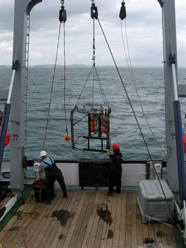
10 2m- beam trawl Video sled 10

11 Hamon grab Timetable It is planned that the fishing intensity study will be undertaken to the below timetable. The project is dependent on permission being issued for the research vessel cruises and the fishing activity, as well as the participation of fishers. Date Task Notes 16/10/2013 Experiment plan submitted 16/10 /2013 to 31/01/2014 Additional information provided by BU to NRW and WG as necessary 16/10 /2013 to 25/ /01/ /2014 BU, WFA and WG to prepare tender document to select fishers to participate in the experiment Deadline for decision to be received by BU team from NRW and WG on permission to undertake the fishing intensity study Commence tender process to select fishers to participate in the experiment 28/02/2014 Complete tender process 10/03/2014 Notify fishers and other stakeholders of outcome of tender process 16/03/2014 Commence research vessel before survey 31/03/2014 Complete research vessel before survey The experiment will not go ahead to this schedule if a decision is not reached by this date 11
12 1/04/2014 Commence experimental fishing 30/04/2014 Complete experimental fishing 1/05/2014 Commence research vessel after survey 24/05/2014 Complete research vessel after survey 10/2014 Undertake research vessel survey to monitor recovery Exact date to be determined References Lambert, G. I., Murray, L.G., Bennell J.D. & Kaiser, M.J. (2013). Habitat assessment of the area of the Cardigan Bay SAC proposed for a fishing intensity experiment. Fisheries & Conservation report No. 23, Bangor University. Pp.51 12
European Fisheries Fund Project. Sustainable Use of Fisheries Resources in Welsh Waters
 European Fisheries Fund Project Sustainable Use of Fisheries Resources in Welsh Waters Welsh Waters Scallop Strategy Industry working group meeting 1 st February 2013 Sustainable Use of Fisheries Resources
Welsh Waters Scallop Strategy 28 th May Summary of research
 Welsh Waters Scallop Strategy 28 th May 2013 Summary of research Introduction This document describes the scallop research being conducted by Bangor University s Fisheries & Conservation Science Group
Habitat assessment of the area of the Cardigan Bay SAC proposed for a fishing intensity experiment
 Bangor University Fisheries and Conservation Report No. 23 Habitat assessment of the area of the Cardigan Bay SAC proposed for a fishing intensity experiment Gwladys Lambert, Lee Murray, James D. Bennell
Aequipecten opercularis fishery management plan. December 2009
 Aequipecten opercularis fishery management plan December 2009 1. BACKGROUND The queen scallop, Aequipecten opercularis, fishery prosecuted around the Isle of Man was entered for assessment against MSC
CMM Conservation and Management Measure for the Management of Bottom Fishing in the SPRFMO Convention Area
 CMM 03-2018 1 Conservation and Management Measure for the Management of Bottom Fishing in the SPRFMO Convention Area The Commission of the South Pacific Regional Fisheries Management Organisation; RECOGNISING
HOW BENTHIC HABITATS AND BOTTOM TRAWLING AFFECT TRAIT COMPOSITION IN THE DIET OF EUROPEAN PLAICE (PLEURONECTES PLATESSA) IN THE NORTH SEA
 IN THE NORTH SEA") HOW BENTHIC HABITATS AND BOTTOM TRAWLING AFFECT TRAIT COMPOSITION IN THE DIET OF EUROPEAN PLAICE (PLEURONECTES PLATESSA) IN THE NORTH SEA Jacqueline Eggleton, Kenny A.J., Bolam S.G., Depestele J., Garcia
HOW BENTHIC HABITATS AND BOTTOM TRAWLING AFFECT TRAIT COMPOSITION IN THE DIET OF EUROPEAN PLAICE (PLEURONECTES PLATESSA) IN THE NORTH SEA Jacqueline Eggleton, Kenny A.J., Bolam S.G., Depestele J., Garcia
Sustainable use of fisheries resources in Welsh waters. European Fisheries Fund Investing in Sustainable Fisheries
 Sustainable use of fisheries resources in Welsh waters Science User Advisory Group (SUAG) Ensure science is fit for purpose and meet industries needs Ensure that results meet objectives stated. Discuss
> >Welcome to the second issue of Fish Briefs! > > > >Articles in Issue Two: > > > >Robert S. Gregory, John T. Anderson. "Substrate selection and use
 Welcome to the second issue of Fish Briefs! Articles in Issue Two: Robert S. Gregory, John T. Anderson. "Substrate selection and use of protective cover by juvenile Atlantic cod Gadus morhua in inshore
7TH ANNUAL MEETING OF THE COMMISSION
 7TH ANNUAL MEETING OF THE COMMISSION 23-27 January 2019, The Hague, The Netherlands COMM7-Prop15.1 Background document: A Proposal for a research fishing Conservation and Management Measure for SPRFMO
Fisheries Unit Welsh Government Rhodfa Padarn Llanbadarn Fawr Aberystwyth SY23 3UR 15 November 2013
 Fisheries Unit Welsh Government Rhodfa Padarn Llanbadarn Fawr Aberystwyth SY23 3UR 15 November 2013 Re: Natural Resources Wales response to Welsh Government s consultation Further Review of the Exceptions
High seas: conservation and management measures to prevent significant adverse impacts on vulnerable marine ecosystems
 High seas: conservation and management measures to prevent significant adverse impacts on vulnerable marine ecosystems ABSTRACT Australia has consented to implement the interim measures adopted in 2007
ECAS 3 rd Periodic Activity Report; Publishable summary
 ECAS 3 rd Periodic Activity Report; Publishable summary Grant Agreement number: 312088 Project acronym: BENTHIS Project title: Funding Scheme: Collaborative project Project coordination: IMARES, IJmuiden,
For the purposes of any clarification and legal interpretation the original byelaw should referred to.
 Sussex Inshore Fisheries and Conservation Authority Byelaw guidance for marine fisheries and conservation management Marine Protected Areas Byelaw 2015 Schedule 1: Kingmere Marine Conservation Zone Introduction
MEDIA RELEASE - 26 May 2015 Stormy Seas Ahead for Industrial Fishing after Factory Trawler Snubs Rec Fishers
 MEDIA RELEASE - 26 May 2015 Stormy Seas Ahead for Industrial Fishing after Factory Trawler Snubs Rec Fishers The Australian Recreational Fishing Foundation (ARFF), the national organisation representing
7 th Annual Meeting of the Commission January, The Hague, The Netherlands
 7 th Annual Meeting of the Commission 23-27 January, The Hague, The Netherlands COMM7-Prop14 Create New CMM on Exploratory Fishing for Toothfish in the SPRFMO Convention Area Submitted by: EUROPEAN UNION
2017 No. 450 SEA FISHERIES. The Sea Fish (Prohibited Methods of Fishing) (Firth of Clyde) Order 2017
 (Firth of Clyde) Order 2017") S C O T T I S H S T A T U T O R Y I N S T R U M E N T S 2017 No. 450 SEA FISHERIES CONSERVATION OF SEA FISH The Sea Fish (Prohibited Methods of Fishing) (Firth of Clyde) Order 2017 Made - - - - 14th December
S C O T T I S H S T A T U T O R Y I N S T R U M E N T S 2017 No. 450 SEA FISHERIES CONSERVATION OF SEA FISH The Sea Fish (Prohibited Methods of Fishing) (Firth of Clyde) Order 2017 Made - - - - 14th December
Marine Management Strategy Frequently Asked Questions
 Marine Management Strategy Frequently Asked Questions Can I still go fishing at Rottnest? Yes Where will I be able to go fishing on Rottnest Island? Recreational fishing can occur at any location outside
MAFF Fisheries Research Technical Report No. 96. P.J. Dare, D.W. Palmer, M.L. Howell and C.D. Darby
 Experiments to assess the relative dredging performances of research and commercial vessels for estimating the abundance of scallops (Pecten maximus) in the western English Channel fishery P.J. Dare, D.W.
Recognising however that an interim management measure for deep pelagic redfish in 2018 in the Irminger Sea and adjacent waters is required;
 Recommendation on Conservation and Management Measures for Deep and Shallow Pelagic Redfish in the Irminger Sea and Adjacent Waters in the NEAFC Convention Area for 2018 As proposed by Denmark, in respect
BEFORE THE ENVIRONMENTAL PROTECTION AUTHORITY JOINT STATEMENT OF EXPERTS IN THE FIELD OF MARINE MAMMALS
 BEFORE THE ENVIRONMENTAL PROTECTION AUTHORITY IN THE MATTER of the Exclusive Economic Zone and Continental Shelf (Environmental Effects) Act 2012 AND IN THE MATTER of an Application for Marine D u m p
Trawl fishery management of Eastern Arabian Sea
 Trawl fishery management of Eastern Arabian Sea Dr. A.P.Dineshbabu, Central Marine Fisheries Research Institute, India Existing management practices Seasonal closure of fishery: The regulations for closed
Explanatory Memorandum to the Scallop Fishing (Wales) Order 2010.
 Order 2010.") Explanatory Memorandum to the Scallop Fishing (Wales) Order 2010. This Explanatory Memorandum has been prepared by the Fisheries Policy Branch of the Department for Rural Affairs and is laid before the
Explanatory Memorandum to the Scallop Fishing (Wales) Order 2010. This Explanatory Memorandum has been prepared by the Fisheries Policy Branch of the Department for Rural Affairs and is laid before the
Fisheries Management Standard. Version 2.0
 Enacted in Japanese: 2017.10.03 Effective in Japanese: 2018.02.01 Fisheries Management Standard Version 2.0 Marine Eco-Label Japan Council (2018) Introduction Marine Eco-Label Japan (MEL) Council have
CMM on the Management of Bottom Fishing in the SPRFMO Convention Area
 Amend 7 th Annual Meeting of the Commission 23-27 January, The Hague, The Netherlands COMM7-Prop03 CMM 03-2018 on the Management of Bottom Fishing in the SPRFMO Convention Area Submitted by: AUSTRALIA
Gulf of Maine Research Institute Responsibly Harvested Seafood from the Gulf of Maine Region Report on Atlantic Sea Scallops (Inshore Canada)
") Gulf of Maine Research Institute Responsibly Harvested Seafood from the Gulf of Maine Region Report on Atlantic Sea Scallops (Inshore Canada) The fishery is managed by a competent authority and has a management
Gulf of Maine Research Institute Responsibly Harvested Seafood from the Gulf of Maine Region Report on Atlantic Sea Scallops (Inshore Canada) The fishery is managed by a competent authority and has a management
Sustainable Fisheries for Future Generations The Fisheries White Paper
 Sustainable Fisheries for Future Generations The Fisheries White Paper Key messages The Fisheries White Paper Sustainable Fisheries for Future Generations charts the course for a sustainable and profitable
CMM Conservation and Management Measure for the Management of New and Exploratory Fisheries in the SPRFMO Convention Area.
 CMM 13-2016 1 Conservation and Management Measure for the Management of New and Exploratory Fisheries in the SPRFMO Convention Area. The Commission of the South Pacific Regional Fisheries Management Organisation;
The EU experience in implementation
 UN Workshop to discuss implementation of paragraphs 80 and 83 to 87 of resolution 61/105 and paragraphs 117 and 119 to 127 of resolution 64/72 in sustainable fisheries, addressing the impacts of bottom
Best Practice Guidance for Assessing the Financial Performance of Fishing Gear: Industry-led gear trials
 Best Practice Guidance for Assessing the Financial Performance of Fishing Gear: Industry-led gear trials Prepared for The UK Fisheries Economic Network (UKFEN) by Seafish Introduction and Background Reducing
FISHERY BY-PRODUCT REPORT
 FISHERY BY-PRODUCT REPORT IFFO GLOBAL STANDARD FOR RESPONSIBLE SUPPLY OF FISHMEAL AND FISH OIL FISHERY By-Product: LOCATION: King Scallop (Pecten maximus) UK & Ireland-Ices Area IVa-c, VI a, VIIa,b,d-h,j2
BASELINE SURVEY, VISUAL - SITE SPECIFIC
 BASELINE SURVEY, VISUAL - SITE SPECIFIC Introduction As stated in SEPA s policy and in the Fish Farm Manual (1998), scientific data are required by SEPA in order to assess the existing condition on the
Can trawling effort be identified from satellite-based VMS data?
 Not to be cited without prior reference to the author International Council for the Exploration of the Seas Theme session N: Technologies for monitoring fishing activities and observing catch Can trawling
Collection of Fisheries Information and Fishing Data by the IFG Network
 Collection of Fisheries Information and Fishing Data by the IFG Network Discussion Paper for IFG Meetings 1. Introduction 1.1 The need to collect basic fishing data to inform management considerations
REGULATIONS RELATING TO MESH SIZES, BYCATCHES AND MINIMUM SIZES, ETC., DURING FISHING OPERATIONS IN THE FISHERIES PROTECTION ZONE AROUND SVALBARD
 REGULATIONS AMENDING THE REGULATIONS RELATING TO MESH SIZES, BYCATCHES AND MINIMUM SIZES, ETC., DURING FISHING OPERATIONS IN THE FISHERIES PROTECTION ZONE AROUND SVALBARD On 5 January 2011, under sections
PRESIDENCY WORKING DOCUMENT
 COUNCIL OF THE EUROPEAN UNION Brussels, 28 May 2003 DS 208/03 LIMITE PRESIDCY WORKING DOCUMT Proposal for a COUNCIL REGULATION on the management of the fishing effort relating to certain Community fishing
Can MPAs Sustain Scallop Fisheries? Bryce Beukers-Stewart, Jo Beukers-Stewart Belinda Vause, Andrew Brand
 Can MPAs Sustain Scallop Fisheries? Bryce Beukers-Stewart, Jo Beukers-Stewart Belinda Vause, Andrew Brand Principles for the Management of UK Scallop Fisheries Provide an overview of the sustainability
Welsh waters scallop survey Cardigan Bay to Liverpool Bay July-August 2013
 Welsh waters scallop survey Cardigan Bay to Liverpool Bay July-August 2013 Lambert, G.I., Murray L.G., Kaiser M.J., Salomonsen, H., Cambie, G. Please cite as follows: Lambert, G.I., Murray L.G., Kaiser
ASSESSMENT OF SCALLOPS (PLACOPECTEN MAGELLANICUS) IN SCALLOP FISHING AREA (SFA) 29 WEST OF LONGITUDE 65 30'W
 IN SCALLOP FISHING AREA (SFA) 29 WEST OF LONGITUDE 65 30'W") Canadian Science Advisory Secretariat Science Advisory Report 2013/055 ASSESSMENT OF SCALLOPS (PLACOPECTEN MAGELLANICUS) IN SCALLOP FISHING AREA (SFA) 29 WEST OF LONGITUDE 65 30'W Figure 1. Location of
Canadian Science Advisory Secretariat Science Advisory Report 2013/055 ASSESSMENT OF SCALLOPS (PLACOPECTEN MAGELLANICUS) IN SCALLOP FISHING AREA (SFA) 29 WEST OF LONGITUDE 65 30'W Figure 1. Location of
Evolution of Deepwater Coral Protection in the Southeast U.S
 Evolution of Deepwater Coral Protection in the Southeast U.S Tina Udouj, Florida Fish and Wildlife Conservation Commission Roger Pugliese, South Atlantic Fishery Management Council Overview Deepwater Corals
English Channel King Scallops
 English Channel King Scallops Research Summary Environmental impacts (MSC Principle 2) Catherall, C. L., Murray, L.G., Bell, E., Rayner, G. & Kaiser, M.J. December 2014 Please cite as follows: Catherall,
CMM on Management of New and Exploratory Fisheries in the SPRFMO Convention Area
 7 th Annual Meeting of the Commission 23-27 January, The Hague, The Netherlands COMM7-Prop11 Amend CMM 13-2016 on Management of New and Exploratory Fisheries in the SPRFMO Convention Area Submitted by:
Developing Fisheries Management Measures for Natura 2000 SAC sites in UK Offshore Waters
 Developing Fisheries Management Measures for Natura 2000 SAC sites in UK Offshore Waters Stanton Banks and Haig Fras case studies Sophie Elliott & Michael McLeod Presentation overview Stanton Banks and
/ Advice May 2011
 1.5.1.3/1.5.4.1 Advice May 2011 ECOREGION SUBJECT General advice Update of cold-water coral and sponge maps and the information underpinning such maps on Vulnerable Marine Habitats (including Hatton and
The Orkney Creel Fishery
 The Orkney Creel Fishery Fishery Improvement Project Work Plan Michael Bell, Kate Walker 2/21/2013 Introduction This work plan has been developed as part of the Fishery Improvement Project (FIP) of the
Trials of a Net Grid for the UK Nephrops trawl fisheries
 Trials of a Net Grid for the UK Nephrops trawl fisheries Tom Catchpole, Frank Armstrong, Stuart Masson, Dave Price, Mark O Brien & John Hingley June 2012 This work was funded by Defra Executive Summary
Haddock, Iceland, ICES Va, Danish Seine
 Haddock, Iceland, ICES Va, Danish Seine Haddock, Iceland, ICES Va, Danish Seine Content last updated 2nd Aug 2017 Stock: Haddock in the Iceland grounds (ICES Division Va) Management: Iceland Overview Haddock
DEPARTMENT FOR ENVIRONMENT, FOOD AND RURAL AFFAIRS CEFAS, LOWESTOFT LABORATORY, SUFFOLK, ENGLAND
 DEPARTMENT FOR ENVIRONMENT, FOOD AND RURAL AFFAIRS CEFAS, LOWESTOFT LABORATORY, SUFFOLK, ENGLAND 2005 RESEARCH VESSEL PROGRAMME PROGRAMME: RV CEFAS ENDEAVOUR: CRUISE 07/05 STAFF: D. Righton (SIC), S. Mackinson
SUMMARY OF PRIORITY RECOMMENDATIONS
 Proposal for a regulation to manage deep-sea fisheries in the North-East Atlantic SUMMARY OF PRIORITY RECOMMENDATIONS October 2014 The European Commission released a proposal in July 2012 (COM(2012)0371)
Bangor University, Fisheries and Conservation Report No 24. Sustainable Use of Fisheries Resources in Welsh Waters Interim Report May 2013
 Sustainable Use of Fisheries Resources in Welsh Waters Interim Report May 2013 1 CONTENTS INTRODUCTION WORK PACKAGE ONE FISHER KNOWLEDGE Progress of questionnaire Communication and industry liaison WORK
Advice June 2012
 2.4.1 Advice June 212 ECOREGION STOCK Iceland and East Greenland Beaked redfish (Sebastes mentella) in Subareas V, XII, and XIV and NAFO Subareas 1+2 (Deep pelagic stock > 5 m) Advice for 213 The advice
7 th Annual Meeting of the Commission January, The Hague, The Netherlands
 7 th Annual Meeting of the Commission 23 27 January, The Hague, The Netherlands COMM7 Report ANNEX 7a CMM for the Management of Bottom Fishing in the SPRFMO Convention Area (COMM 7 Prop 03_Rev4) The Commission
FISHERIES & CONSERVATION SCIENCE GROUP
 FISHERIES & CONSERVATION SCIENCE GROUP ELECTRONIC NEWSLETTER 3 July 2013 Menai Seafood Festival On 31 st August, the first Menai Seafood Festival will be taking place in Menai Bridge and our group is going
1. TAC and quota allocation between Contracting Parties for the deep pelagic fishery
 Recommendation on Conservation and Management Measures for Deep and Shallow Pelagic Redfish in the Irminger Sea and adjacent waters in the NEAFC Convention Area for 2016 As proposed by Denmark (in respect
Northeast Atlantic Mackerel, Handlines
 Northeast Atlantic Mackerel, Handlines Northeast Atlantic Mackerel, Handlines Content last updated 3rd Apr 2017 Stock: Mackerel (Scomber scombrus) in subareas 1 7 and 14, and in divisions 8.a e and 9.a
REC.CM-GFCM/40/2016/4
 REC.CM-GFCM/40/2016/4 establishing a multiannual management plan for the fisheries exploiting European hake and deep-water rose shrimp in the Strait of Sicily (GSA 12 to 16) The General Fisheries Commission
establishing further emergency measures in 2017 and 2018 for small pelagic stocks in the Adriatic Sea (GSA 17 and GSA 18)
") REC.CM-GFCM/40/2016/3 establishing further emergency measures in 2017 and 2018 for small pelagic stocks in the Adriatic Sea (GSA 17 and GSA 18) The General Fisheries Commission for the Mediterranean (GFCM),
REC.CM-GFCM/40/2016/3 establishing further emergency measures in 2017 and 2018 for small pelagic stocks in the Adriatic Sea (GSA 17 and GSA 18) The General Fisheries Commission for the Mediterranean (GFCM),
Framework 35 Northeast Multispecies FMP
 and 2. In addition to small mesh multispecies, vessels target herring in Small Mesh Areas 1 and 2 and therefore use mesh smaller than 2.5-inches in the codend. The net specifications listed in Section
7 th Annual Meeting of the Commission January, The Hague, The Netherlands
 7 th Annual Meeting of the Commission 23 27 January, The Hague, The Netherlands COMM7 Report ANNEX 7L CMM on Exploratory Fishing for Toothfish by New Zealand flagged Vessels (COMM7 Prop13_Rev1) The Commission
Recommendations for the meeting of the North-East Atlantic Fisheries Commission 9-13 November 2009
 Recommendations for the meeting of the North-East Atlantic Fisheries Commission 9-13 November 2009 This Annual Meeting of the NEAFC Commission is the first meeting after the 31 st of December 2008 deadline
Consultation Document
 Consultation Document Development of a regulation establishing a multiannual plan for the management of Northern Adriatic Sea small pelagic fisheries The sole purpose of this consultation is to collect
Why has the cod stock recovered in the North Sea?
 Why has the cod stock recovered in the North Sea? Summary The expansion of European fisheries during the 1970s and 1980s resulted in high fishing pressure on stocks of cod, haddock, whiting and saithe
Sea Views SEACAMS. month s edition. In this. Business aboard the RV Prince Madog What do seals do underwater? All aboard the RV Prince Madog
 February 2013 SEACAMS Sea Views In this month s edition Business aboard the RV Prince Madog What do seals do underwater? All aboard the RV Prince Madog 0845 519 9029 www.seacams.ac.uk ebost: email: info@seacams.ac.uk
Three different funding sources funded different facets of the research.
 Three different funding sources funded different facets of the research. In November 2014, the research team received monies from the N.C. Marine Fisheries Commission s Conservation Fund, with matching
R.P. Prabath K. JAYASINGHE National Aquatic Resources Research and Development Agency (NARA) Colombo 15 SRI LANKA
 Colombo 15 SRI LANKA") Experience and the special requirements of Sri Lanka in addressing the impacts of bottom fisheries on vulnerable marine ecosystems and the long-term sustainability of deep-sea fish stocks in particular
Experience and the special requirements of Sri Lanka in addressing the impacts of bottom fisheries on vulnerable marine ecosystems and the long-term sustainability of deep-sea fish stocks in particular
Case Study 3. Case Study 3: Cebu Island, Philippines MPA Network 10
 Case studies of mpa networks Case Study 3: Cebu Island, Philippines MPA Network 10 Location and background Cebu Island in the Philippines lies in the center of the Visayan Islands, known as an area high
Undulate ray (Raja undulata) in divisions 8.a b (northern and central Bay of Biscay)
 in divisions 8.a b (northern and central Bay of Biscay)") ICES Advice on fishing opportunities, catch, and effort Bay of Biscay and the Iberian Coast Ecoregion Published July 13 2018 https://doi.org/10.17895/ices.pub.4502 Undulate ray (Raja undulata) in divisions
ICES Advice on fishing opportunities, catch, and effort Bay of Biscay and the Iberian Coast Ecoregion Published July 13 2018 https://doi.org/10.17895/ices.pub.4502 Undulate ray (Raja undulata) in divisions
GITAG. Gear Innovation and Technology Advisory Group
 GITAG Gear Innovation and Technology Advisory Group Phase 2 industry based project established in August 2015 to foster flexible working partnerships between active fishers, industry and public bodies,
Proposed fisheries management measures for English offshore MPAs in the Channel, the Southwest Approaches and the Irish Sea
 Proposed fisheries management measures for English offshore MPAs in the Channel, the Southwest Approaches and the Irish Sea Date: 28 February 2017 Paris Designation and Management of Marine Protected Areas
NASCO Guidelines for the Management of Salmon Fisheries
 NASCO Guidelines for the Management of Salmon Fisheries NASCO Guidelines for the Management of Salmon Fisheries Additional copies of these Guidelines can be obtained free of charge from: The Secretary
SUMMARY OF THE IMPLEMENTATION OF EU REGULATION 1967/2006
 DIRECTORATE-GENERAL FOR INTERNAL POLICIES POLICY DEPARTMENT B: STRUCTURAL AND COHESION POLICIES FISHERIES SUMMARY OF THE IMPLEMENTATION OF EU REGULATION 1967/2006 NOTE This document was requested by the
NOTIFICATION OF PROPOSED RESEARCH CRUISE
 1 NOTIFICATION OF PROPOSED RESEARCH CRUISE PART A: GENERAL 1. NAME OF RESEARCH SHIP: "G.O.Sars" CRUISE NO. 2012102 2. DATES OF CRUISE From: 15 February 2012 To: 14 March 2012 3. OPERATING AUTHORITY: Institute
LIFE BaĦAR for N2K Project Survey Findings. Leyla Knittweis on behalf of the LIFE BaĦAR for N2K Project
 LIFE BaĦAR for N2K Project - 2015 Survey Findings Leyla Knittweis on behalf of the LIFE BaĦAR for N2K Project Legally Protected Habitats Habitats Directive Directive 92/43/EEC: Protected marine habitats:
Glossary. Action point or trigger point or level
 Glossary Term Acoustic surveys Action point or trigger point or level Age determination Benthic organisms or benthos Biogenic reefs BMSY Bycatch Catch per unit effort Confidence intervals Control Demersal
The Protection of Vulnerable Marine Ecosystems in the Northwest Atlantic: NAFO Processes and Regulations
 The Protection of Vulnerable Marine Ecosystems in the Northwest Atlantic: NAFO Processes and Regulations Dr. Ricardo Federizon Senior Fisheries Commission Coordinator Northwest Atlantic Fisheries Organization
Official Journal of the European Union. (Legislative acts) REGULATIONS
 REGULATIONS") 29.5.2015 L 133/1 I (Legislative acts) REGULATIONS REGULATION (EU) 2015/812 OF THE EUROPEAN PARLIAMT AND OF THE COUNCIL of 20 May 2015 amending Council Regulations (EC) No 850/98, (EC) No 2187/2005, (EC)
29.5.2015 L 133/1 I (Legislative acts) REGULATIONS REGULATION (EU) 2015/812 OF THE EUROPEAN PARLIAMT AND OF THE COUNCIL of 20 May 2015 amending Council Regulations (EC) No 850/98, (EC) No 2187/2005, (EC)
Irish Wildlife Trust s Guide to Sustainable Seafood
 IrishWildlifeTrust s GuidetoSustainableSeafood WrittenbyPádraicFogartyandDeirdreHoare IllustrationsbyChelseaMacClanahan PhotographsbyMarkThomasandMikeBrown Whiting Thesefishwereoncedinnertimefavouritesbuthavenowbeenoverfishedtothepointwhererecoveryintheshorttomediumterminthe
COMMISSION OF THE EUROPEAN COMMUNITIES. Proposal for a COUNCIL REGULATION
 COMMISSION OF THE EUROPEAN COMMUNITIES Brussels, 24.7.2006 COM(2006) 411 final 2006/0134 (CNS) Proposal for a COUNCIL REGULATION Establishing a multi-annual plan for the cod stocks in the Baltic Sea and
Understanding shelf-break habitat for sustainable management of fisheries with spatial overlap
 Understanding shelf-break habitat for sustainable management of fisheries with spatial overlap Alan Williams Caleb Gardner Franziska Althaus Bruce Barker David Mills Final Report to the Fisheries Research
Fast Tracking the Development of Environmental- Friendly Fishing Methods
 Irish Presidency of the Council of Fisheries Ministers of the European Union Ministerial & Stakeholders Conference Fast Tracking the Development of Environmental- Friendly Fishing Methods Norwegian efforts
ADDENDUM I TO AMENDMENT 3 OF THE INTERSTATE FISHERY MANAGEMENT PLAN FOR WEAKFISH
 ATLANTIC STATES MARINE FISHERIES COMMISSION ADDENDUM I TO AMENDMENT 3 OF THE INTERSTATE FISHERY MANAGEMENT PLAN FOR WEAKFISH Prepared by the Weakfish Plan Review Team Approved October 18, 2000 TABLE OF
Management advisory for the Bay of Bengal hilsa fishery June 2012
 Page1 Management advisory for the Bay of Bengal hilsa fishery June 2012 What is the BOBLME RFMAC The BOBLME Project is supporting countries to implement an ecosystem approach to fisheries management of
Falmouth and St.Austell pspa bird bycatch analysis report year
 Natural England Commissioned Report NECR231 Falmouth and St.Austell pspa bird bycatch analysis report year 1-2014 First published 20 April 2017 www.gov.uk/natural-england Foreword Natural England commission
STECF EXPERT WORKING GROUP EWG 15-12, including a preliminary meeting on data preparation
 STECF EXPERT WORKING GROUP EWG 15-12, including a preliminary meeting on data preparation Stock assessments in the Black Sea 24 September 2 October 2015 1, Barza d'ispra, Italy DG Mare focal person: Xavier
The economic implications of changing regulations for deep sea fishing: UK case study
 The economic implications of changing regulations for deep sea fishing: UK case study Stephen Mangi, Andrew Kenny, Lisa Readdy, Paulette Posen, Ana Ribeiro-Santos, Francis Neat and Finlay Burns Mangi et
Proposed Marine Park in the Brothers Islands
 Proposed Marine Park in the Brothers Islands PURPOSE This paper presents the preliminary plan of the proposed marine park in the Brothers Islands (BIMP) for protection and enhancement of Chinese White
ICES WGCSE REPORT
 ICES WGCSE REPORT 2009 291 6 Irish Sea 6.1 Area overview Description of fisheries Fishing effort and vessel numbers within the Irish Sea have declined in recent years by around 28% and 15% respectively
Submission on summary of the Draft Convention on Biological Diversity National Report
 23 November 2018 Submission on summary of the Draft Convention on Biological Diversity National Report The New Zealand Marine Sciences Society (NZMSS) is a professional society affiliated to the Royal
Spurdog (Squalus acanthias) in the Northeast Atlantic
 in the Northeast Atlantic") ICES Advice on fishing opportunities, catch, and effort Northeast Atlantic Published 11 October 2016 9.3.17 Spurdog (Squalus acanthias) in the Northeast Atlantic ICES stock advice ICES advises that when
ICES Advice on fishing opportunities, catch, and effort Northeast Atlantic Published 11 October 2016 9.3.17 Spurdog (Squalus acanthias) in the Northeast Atlantic ICES stock advice ICES advises that when
Sourced from:
 Catch Comparison trials using a 400mm Square Mesh Panel Louise Jones SFF Data Analyst Sourced from: http://www.worldfishingtoday.com/newbuildings/default.asp?nyid=621277 Summary: The 400mm SMP alone is
COMMISSION DELEGATED REGULATION (EU)
") L 336/42 COMMISSION DELEGATED REGULATION (EU) 2015/2440 of 22 October 2015 establishing a discard plan for certain demersal fisheries in the North Sea and in Union waters of ICES Division IIa THE EUROPEAN
L 336/42 COMMISSION DELEGATED REGULATION (EU) 2015/2440 of 22 October 2015 establishing a discard plan for certain demersal fisheries in the North Sea and in Union waters of ICES Division IIa THE EUROPEAN
Natura 2000 and fisheries: a question of competence or willingness?
 Natura 2000 and fisheries: a question of competence or willingness? Conference 20 years of Habitats Directive: European Wildlife s Best Hope? Antwerp, 12-13 December 201 Harm M. Dotinga Current situation
Fishery Report 2017: Dissostichus spp. (Subarea 48.2)
") Fishery Report 2017: Dissostichus spp. (Subarea 48.2) FISHERY REPORT The map above shows the management areas within the CAMLR Convention Area, the specific region related to this report is shaded. Throughout
Fishery Report 2017: Dissostichus spp. (Subarea 48.2) FISHERY REPORT The map above shows the management areas within the CAMLR Convention Area, the specific region related to this report is shaded. Throughout
2017 CONSERVATION HARVESTING PLAN Atlantic Halibut (4RST) Prince Edward Island fixed gear fleet Less than meters
 Prince Edward Island fixed gear fleet Less than meters") Approved on July 13, 2017 APPLICATION This Conservation Harvesting Plan (CHP) applies to all Prince Edward Island (PEI) fixed gear licence holders fishing Atlantic halibut in NAFO Divisions 4RST with vessels
Approved on July 13, 2017 APPLICATION This Conservation Harvesting Plan (CHP) applies to all Prince Edward Island (PEI) fixed gear licence holders fishing Atlantic halibut in NAFO Divisions 4RST with vessels
Certification Determination. Louisiana Blue Crab Commercial Fishery
 15 th November 2016 Certification Determination For The Louisiana Blue Crab Commercial Fishery Following a meeting of a Global Trust Certification Committee on 20 th October 2016, a positive determination
82 ND MEETING RESOLUTION C RESOLUTION TO MITIGATE THE IMPACT ON SEABIRDS OF FISHING FOR SPECIES COVERED BY THE IATTC
 INTER-AMERICAN TROPICAL TUNA COMMISSION 82 ND MEETING LA JOLLA, CALIFORNIA (USA) 4 8 JULY 2011 RESOLUTION C-11-02 RESOLUTION TO MITIGATE THE IMPACT ON SEABIRDS OF FISHING FOR SPECIES COVERED BY THE IATTC
FISHERIES MANAGEMENT ACT 1998
 FISHERIES MANAGEMENT ACT 1998 THE GULF OF PAPUA PRAWN FISHERY MANAGEMENT PLAN THE NATIONAL FISHERIES AUTHORITY, by virtue of the powers conferred by Section 28 of the Fisheries Management Act 1998, and
NZ s Fishery Management Framework The Fisheries Act 1996 & Spatial Management Tools
 NZ s Fishery Management Framework The Fisheries Act 1996 & Spatial Management Tools Inshore Fisheries Management 24 November 2014 www.mpi.govt.nz www.mpi.govt.nz 1 Brief outline 1. Historical context resources
Scottish Hydro Electric Power Distribution Operation, Inspection, Maintenance and Decommissioning Strategy Bute Cumbrae Cable Replacement
 SHEPD Section ID 154 Scottish Hydro Electric Power Distribution Operation, Inspection, Maintenance and Decommissioning Strategy Bute Cumbrae Cable Replacement Contents Definitions and Abbreviations...
Norway lobster (Nephrops norvegicus) in Division 4.a, Functional Unit 32 (northern North Sea, Norway Deep)
 in Division 4.a, Functional Unit 32 (northern North Sea, Norway Deep)") ICES Advice on fishing opportunities, catch, and effort Greater North Sea Ecoregion Published 29 June 2018 Version 2: 14 November 2018 https://doi.org/10.17895/ices.pub.4439 Norway lobster (Nephrops norvegicus)
ICES Advice on fishing opportunities, catch, and effort Greater North Sea Ecoregion Published 29 June 2018 Version 2: 14 November 2018 https://doi.org/10.17895/ices.pub.4439 Norway lobster (Nephrops norvegicus)
Three Rivers Cockle Abundance Survey Report April 2016
 Three Rivers Cockle Abundance Survey Report April 16 May 16 Crown Copyright WG 2884 ISBN digital 978-1-4734-669-6 1. Introduction The annual Three Rivers Estuaries cockle abundance survey was conducted