BISON CONTROL AREA PROGRAM ANNUAL REPORT OF SURVEY ACTIVITIES NOVEMBER 2006 APRIL 2007
|
|
|
- Britton Byrd
- 6 years ago
- Views:
Transcription
1 i BISON CONTROL AREA PROGRAM ANNUAL REPORT OF SURVEY ACTIVITIES NOVEMBER 2006 APRIL 2007 Bart Hartop, William Mandeville, Nahum Lee, and Deborah Johnson Environment and Natural Resources Government of the Northwest Territories Fort Smith, NT X0E 0P Manuscript Report No. 216 The contents of this paper are the sole responsibility of the authors
2 ii
3 iii ABSTRACT Bovine tuberculosis (Mycobacterium bovis) and brucellosis (Brucella abortus) are endemic in bison (Bison bison) herds in and around Wood Buffalo National Park, and the adjacent Slave River Lowlands. In 1987, the Bison Control Area (BCA), along with a surveillance program, was created to minimise the risk of disease transmission to the disease-free Mackenzie and Nahanni Liard herds in the Northwest Territories. During the surveillance season, we used a Cessna 337, to fly 12 shoreline patrols along the northern boundary of the BCA on a weekly basis from December 20, 2006 to April 12, Total survey time during shoreline patrols was 26.5 hours. We used a Cessna 210 to fly one semi-comprehensive aerial survey of BCA zone І and partial Zone II, from February 2007; total survey time was 18.5 hours. From March 2007, we used a Cessna 210 to fly the annual comprehensive survey of BCA zones І and ІІ; total survey time was 35.9 hours. In total, we flew 92.8 hours, including ferry time, to systematically survey the BCA during the surveillance season and did not observe any bison (or their sign, i.e., fresh tracks and/or feeding craters) within the BCA during our surveillance flights.
4 iv Table of Contents Subject Page No Abstract... iii List of Tables... v List of Figures... v List of Photographs v Introduction... 1 The Bison Control Area Program... 5 Goals and Objectives... 6 Method... 8 Results Shoreline Patrols Surveillance Surveys Wildlife Observations Communications Discussion Acknowledgements Literature Cited Appendix A: Summary of Weather Conditions Appendix B: Summary of Surveillance & Removals Appendix C: Radio Broadcasts Appendix D: Add in Explorer's Guide Appendix E: Presentations E (1) Presentation for Community Meetings. 46 E (2) Presentation for schools
5 v List of Tables Table Subject Page No. Table 1 Summary of shoreline patrols Table 2 Summary of surveillance flights Table 3 Summary of recorded large mammal sightings List of Figures Figure Subject Page No. Figure 1 Distribution of bison in northern Canada. 4 Figure 2 The Northwest Territories Bison Control Area. 6 Figure 3 Standardized shoreline patrol route Figure 4 Routes flown in the semi-comprehensive survey Figure 5 Routes flown in the March comprehensive survey Figure 6.1 Map showing the route of patrol Figure 6.2 Map showing the route of patrol Figure 6.3 Map showing the route of patrol Figure 6.4 Map showing the route of patrol Figure 6.5 Map showing the route of patrol Figure 6.6 Map showing the route of patrol Figure 6.7 Map showing the route of patrol Figure 6.8 Map showing the route of patrol Figure 6.9 Map showing the route of patrol Figure 6.10 Map showing the route of patrol Figure 6.11 Map showing the route of patrol Figure 6.12 Map showing the route of patrol Figure 7.1 Large animal sightings observed during the semi-comprehensive survey Figure 7.2 Map showing large mammal tracks located during the February semi-comprehensive survey Figure 7.3 Large mammal track sighting shown in relation to wolf kills Figure 7.4 Large mammal and significant smaller mammal track sightings Figure 8.1 Large mammals observed during the March comprehensive survey Figure 8.2 Map showing large mammal tracks stratified by species Figure 8.3 Larger mammal and associated smaller mammal tracks. 29 List of Photographs Slide No. Subject Page No. Slide 1 View of the Mackenzie River looking North Slide 2 Photo of Typical BCA Topography Slide 3 Meeting with Hay River Metis Government Council January 18,
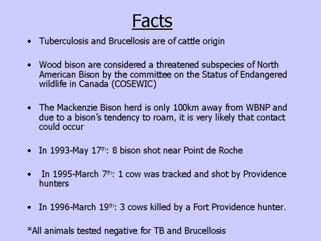
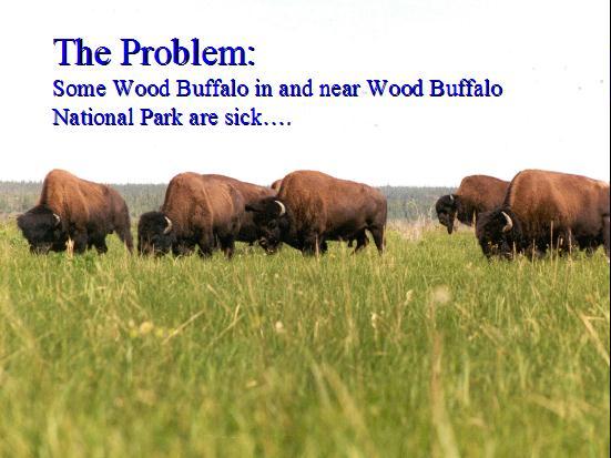
6 1 INTRODUCTION Free-ranging wood bison (Bison bison athabascae) in and around Wood Buffalo National Park (WBNP) and the Slave River Lowlands (SRL) are infected with bovine tuberculosis and brucellosis (Tessaro et al. 1990, Joly and Messier 2001) (Figure1). These northern bison herds contracted the two cattle diseases when 6,673 diseased plains bison were moved from the National Buffalo Park at Wainright, Alberta to WBNP between 1925 and 1928 (Fuller 2002). Risk of infection to healthy free-ranging bison as well as commercial cattle and bison herds has been a chronic management problem ever since (see Connelly et al. 1990, APFHRAN 1999, RAC 2001). Results from Jolly and Messier (2004) showed that bison within WBNP have overall apparent prevalence rates of 49% and 31% for tuberculosis and brucellosis respectively. These results suggest that the diseases will continue to persist in the affected bison in and around WBNP and further supports the need to mitigate the risk of infection to the health status of the Mackenzie Wood Bison herd (Tessaro et al. 1993, Nishi 2002), the presumed disease free status of the Hay-Zama herd located in northwest Alberta, and the Nahanni-Liard herd located near the Mackenzie Mountains (Gates et al. 1992a) (Figure 1). The diseased bison in and around WBNP also present the most important limiting factor to the reestablishment of other healthy free-roaming herds in the region that could contribute to the resource-based economies of surrounding communities (Gates et al. 2001b).
7 2 In March 1996, because of ongoing concerns of the commercial bison industry, the Canadian Bison Association requested the Animal, Plant and Food Health Risk Assessment Network (APFRAN), and the Canadian Food Inspection Agency to conduct a formal risk assessment. The objective was to determine the risk of infection with tuberculosis and/or brucellosis from bison in WBNP and surrounding area during a 12 month period, for each of three at risk groups: commercial cattle, commercial captive bison and disease-free, free-ranging bison. In January 1999, APFRAN completed the risk assessment and concluded that disease-free, free-ranging bison had the highest probability of becoming infected with bovine brucellosis and/or tuberculosis (APFRAN 1999). As the APFRAN (1999) disease risk assessment was not based on terrain and habitat variability, a follow-up research project was initiated to compile local knowledge on bison movement and distribution around WBNP, define the relative influences of biophysical and management factors, and to integrate quantitative and local qualitative data on biophysical factors into a bison movement model (Gates et al. 2001a, Mitchell 2002). The research focused on bison movements and distribution in the region in order to provide a model and maps for informing the development of disease risk management measures and to update the APFRAN risk model. The results suggested that the highest likelihood for bison dispersal occurred in corridors that were parallel to the Peace River in the area of Fort Vermillion, and with the broadest network of corridors between High Level and WBNP. Additional results from Gates and Wierzchowski s (2003) movement corridor analysis indicate that potential movements of bison between WBNP and the Mackenzie
8 3 Bison Range are most likely to occur in the northern section of surveillance Zone I in the Bison Control Area (BCA). Gates and Wierzchowski (2003) recommended that in addition to the in-situ surveillance of BCA Zone I, aerial surveillance of the area between Buffalo Lake and Highway #5 should be conducted to ensure that the disease-free Mackenzie herd do not come into contact with infected bison that may occupy this area. Due to the propensity of bison to use meadows near lakes and rivers, they also suggested that aerial reconnaissance of the area on the northwest side of Buffalo Lake might be worthwhile. Continuation of shoreline and surveillance surveys is critically important for early detection of bison in the control area, due to the ongoing risk of disease transmission from WBNP bison to the Mackenzie and Nahanni bison herds.

9 4 Wood Bison Herd Distribution In British Columbia, Alberta, & the NWT Figure 1 Distribution of bison herds in Northern Canada. For the most recent information, visit Note: Bison herds considered to be infected with bovine tuberculosis and brucellosis are shown in light green; HL = Hook Lake, LBR = Little Buffalo River, NY = Nyarling, HC=Hay Camp, GR=Garden River, DL=Peace-Athabasca Delta, FB=Fire Bag, WZ=Wentzel, WA=Wabasca, BM=Birch Mountain. Bison herds considered to be disease-free are shown in light beige grey; MB = Mackenzie, NH = Nahanni, PM= Pink Mountain, HZ = Hay Zama, SY = Syncrude/Fort McKay. The delineation of home ranges originated from various research (Reynolds & Hawley 1987, Joly & Messier 2001, Harper et.al 2000, Wood Buffalo National Park, Resources, Wildlife and Economic Development, British Columbia Ministry of Environment, and Alberta Environment.)
10 5 The Bison Control Area Program In 1987, the Government of the Northwest Territories (GNWT) implemented a program to reduce the risk of contact between infected and disease-free bison (Gates and Gray 1992; Gates et al 1992b). The program entailed defining an area, the Bison Control Area (BCA), from which bison are excluded through surveillance and active management. The BCA originally included lands south of the Mackenzie River and North of the Mackenzie Highway between Mills Lake (near Fort Providence) and Hay River. In 1990, the BCA was expanded to encompass the area between the Alberta-NWT border and southern shoreline of the Mackenzie River; the western boundary was delineated by Trout River; the eastern boundary was outlined by the Buffalo River and western boundary of WBNP (Figure 2). Presently, the BCA encompasses 3, 936km 2. Since 1993, the Government of the Northwest Territories (Department of Environment and Natural Resources) and the Government of Canada (Parks Canada) have jointly funded the Bison Control Area Program (BCAP). Cost of surveying the BCA is jointly funded under a Memorandum of Understanding between the two agencies. This report summarizes the results of the Bison Control Area Program for the 2006/2007 surveillance season (i.e. December April 2007).

11 6 Figure 2 The Northwest Territories Bison Control Area showing the three surveillance zones. Goals and Objectives The goal of the Bison Control Area Program in the Northwest Territories is to reduce the risk of infection of the Mackenzie and Nahanni herds with tuberculosis and brucellosis. Our overall approach to achieve this goal is to conduct systematic aerial surveys with an extensive public communication program.
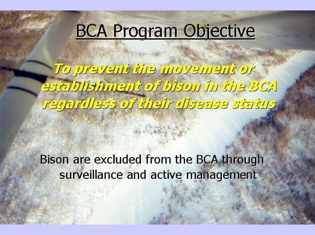
12 7 The objectives of the Bison Control Area Program are to: Detect and remove any bison in the BCA, and to prevent establishment of bison herds or individuals in this area 1 ; Continue surveillance of the bison control area; and Increase public awareness of the Bison Control Program. Slide 1 View of the Mackenzie River looking north west towards Fort Providence and representing the area covered during the shoreline patrols. 1 Wood bison (Bison bison athabascae) are a threatened subspecies of North American Bison and listed as such on the federal Species at Risk Act (SARA). They are also listed on Appendix II by the Convention on the International Trade In Endangered species (CITES). Because of the disease risk, any bison found in the BCA are considered nuisance wildlife under section 61 of the NWT Wildlife Regulations Act (Government of the Northwest Territories 1992). This regulation states that NWT residents may shoot any bison sighted in the BCA.
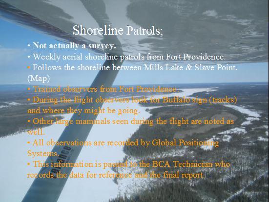
13 8 METHOD To ensure consistency and comparability of search effort and resulting wildlife observations, the same survey methodology was used as previous years (Gates and Gray 1992, Gates et al. 1992, Williamson et al. 1995, Antoniak and Gates 1996, Bohnet and Gates 1997, Boulanger et al & 2001, Tanguay, et al. in prep, Potvin et al. in prep, Jewell et al. in prep, Campbell et al ). The BCA is stratified into three discrete zones (Figure 2). Active surveillance through aerial observation is conducted during winter months when bison and bison sign are most discernible (i.e., tracks and/or feeding craters) and visibility is optimal. Survey effort and frequency of monitoring is allocated according to the presumed likelihood of bison moving into the area (see AFRAN 1999). Consequently, this survey design requires frequent (weekly) surveys of the shoreline areas that are closest to the range of Mackenzie Bison Herd and the range of bison in WBNP. Less frequent surveys (semicomprehensive and annual comprehensive) are used to survey larger areas (BCA Zones I and II) in the BCA. We flew three different types of aerial surveys to systematically survey the BCA throughout the surveillance season. The first type of survey was a weekly shoreline patrol of the high-risk area (Zone I). We continued to fly a slightly revised standard shoreline patrol route as recommended by Tanguay et al. after the season (Tanguay et al. in prep) (Figure 3). This route was extended to include the Slave Point area, as in the previous season, there had been several reports of bison tracks leading from that area to Point De Roche in the BCA and this information warranted the monitoring of that area.

14 9 This survey was conducted at approximately seven-day intervals and had a planned flight time of about two and one half hours per patrol flight. Figure 3 Standardized shoreline patrol route for the Bison Control Area flown in season. The second type of survey was a one-time semi-comprehensive surveillance flight of Zone I; this survey was performed in February This survey covers a larger area and requires about 15 hours to complete. The final survey type was the annual comprehensive surveillance flight of Zones I and II. For this annual comprehensive survey performed in late March, we allocated approximately 35 hours of flight time. We did not conduct aerial surveys in Zone III of the BCA.
15 10 Shoreline patrols were flown in a Cessna 337. Both the semi-comprehensive survey and the annual comprehensive survey flights were performed using a Cessna 210. A local community observer and pilot from Landa Aviation in Hay River conducted all shoreline patrols. There was no requirement to conduct verification flights. The survey crew for the surveillance flights of Zone I and the annual comprehensive survey of Zones I and II consisted of a pilot, the BCA Technician and two community observers. The technician sat in the front seat while the observers occupied the left and right rear seats of the aircraft. Survey aircraft were flown at approximately 250 to 300 metres above ground level at an air speed of approximately 190 km/hr. We adapted flight paths from previous surveys to plan our routing for aerial surveys in the surveillance season. However, routes used in previous years, for both the semi-comprehensive and comprehensive surveys were updated and restructured this season in order to put an emphasis on areas of probable importance, as identified by local observers and past BCA reports. We continued to extend survey lines into the northwest corner of WBNP, in addition to concentrating more coverage in higher risk areas (see Figure 5.1 and 6.1). Utilising predetermined flight routes ensures maximum coverage for both surveillance surveys, and allows the BCA Technician to pre-plan fuel stops and breaks, which increases survey efficacy and improves safety. Pre-planned routes were used as a guide, and followed for the bulk of the survey only deviating from them to investigate animal tracks or other abnormal activities such as wolf kills; in this way we could be sure of consistency and some accuracy in the area covered. This allowed us to survey Zones I and II with the greatest possible coverage given available flying hours.
 width of 500 metres and positioned electrical tape on the windows of the aircraft to define")
16 11 Figure 4 Actual routes flown for the semi-comprehensive survey February 13 th to 16 th, 2007, from Hay River & Fort Providence, NWT. To improve sampling quality and precision during surveillance surveys, we employed a known strip (transect) width of 500 metres and positioned electrical tape on the windows of the aircraft to define the boundaries of the strip within which the observers count animals. With the aid of observers, the BCA technician affixed the markers prior to flights using a known calculation [w = (W/H)*h]. Once this exercise was complete, a test flight was carried out to ensure marker placement accuracy; the test flight entailed positioning the aircraft alongside a known 500-metre length on the ground, at survey altitude, and confirming whether the fixed tape positions aligned with the known

17 12 ground length. Implementing a known strip (transect) width enables us to accurately calculate percent cover. Figure 5 Routes Flown for the March comprehensive survey completed March 19th to 24 th, Wildlife observations during weekly shoreline patrols were most often recorded on a NTS 1:250,000-reproduction map of the survey area. This was entered into an Excel spreadsheet and then transferred into a Database IV file format for export into Arc Map 9.1 Geographic Information System (Environmental Systems Research Institute, ). An Ozi Explorer Mapping program (Des Newman, version: ) was used to plot the route grid for the survey routes, this was uploaded into a hand-held Garmin GPS
.")
18 13 map 76S, and was used by the pilot for navigation and to maintain adherence to the planned routes. The survey routes plotted in Ozi Explorer were verified and checked and entered into ASPEN Global Positioning System Field Software (Trimble Survey and Mapping Products, 1998). All observations of large mammals (i.e., moose, caribou, and wolves) were recorded using ASPEN Global Positioning System Field Software, during the semi-comprehensive and annual comprehensive flights. These data were prepared for export to Arc Map 9.1, with Pathfinder Office Software (Trimble Survey and Mapping Products, 1998). Slide 2 Photo of typical BCA topography near Buffalo Lake looking towards the Cameron Hills.
19 14 RESULTS Our aerial surveys were conducted during optimum snow and light conditions, whenever possible. However, some flights were conducted in less suitable conditions in order to maintain adequate and regular surveillance (Appendix A). Shoreline Patrols Weekly shoreline patrols were initiated on December 20, 2006 and continued until April 12, 2007 (Figures Maps). The BCA technician accompanied the observer to provide and establish the required data collection protocol and assess the actual location of the patrol route. The route was extended to include the Slave Point area, due to previous reports of possible bison tracks into the BCA from that area. By monitoring the area on a weekly basis it was believed that the program would have a good indication of bison activity, should future reports of tracks into the BCA from Slave Point be received. With the exception of patrol number one, bison were seen in the Slave Point area. Total flight time for the 12-shoreline patrols flown was 38.4 hours 2 (Table.1) with a mean duration of 3.2 (± 0.25 Standard Deviation) hours. A Cessna 337 was used to complete all shoreline patrols. On April 12, 2007 the last scheduled shoreline patrol flight was flown. This flight was again made with the BCA technician to assess snow conditions and the potential risk of bison movement into the BCA. It was determined that ice conditions in these areas would likely continue to degrade very quickly and deter bison from crossing the Mackenzie River. Also, although snow conditions still allowed for the identification of tracks during this patrol, the forecasted warm weather (10 o C to 2 Total flight time for shoreline patrols includes ferry time.
20 15 12 o C in the Fort Providence area) for the following four days would rapidly eliminate any chances of further track identification. In respect of these observed conditions, we made the decision to discontinue shoreline patrol surveys for the 2006/2007 season, before the next planned shoreline patrol on April 18, Table 1 Summary of shoreline patrols in the Bison Control Area from December 2006 to April Date Ferry Hrs Survey Hrs Date Ferry Hrs Survey Hrs 20-Dec Feb Dec Mar Jan Mar Jan Mar Jan Apr Jan April Total ferry hours 12.0 Total survey hours: 26.5
21 16 Figure 6.1 Map of patrol number one, completed December 20, 2006, with a duration of 2.5 hours transect time. Figure 6.2 Map of patrol number two, completed December 31 st 2006, with a duration of 2.2 hours transect time.

22 17 Figure 6.3 Map of patrol number three completed January 5 th 2007, with a duration of 2.1 hours transect time. Figure 6.4 Map of patrol number four completed January 11 th 2007, with a duration of 2.0 hours transect time.
23 18 Figure 6.5 Map of patrol number five, completed January 18 th 2007, with a duration of 2.9 hours transect time. Figure 6.6 Map of patrol number six, completed January 24 th, 2007, with a duration of 2.7 hours transect time.

24 19 Figure 6.7 Map of patrol number seven, completed February 3 rd 2007, with a duration of 2.2 hours transect time. Figure 6.8 Map of patrol number eight, completed March 8 th 2007, with a duration of 1.9 hours transect time.
25 20 Figure 6.9 Map of patrol number 9, completed March 14 th 2007 with a duration of 1.8 hours transect time. Figure 6.10 Map of patrol number 10 completed March 28 th 2007 with a duration of 2.0 hours transect time.


26 21 Figure 6.11 Map of patrol number 11, completed April 5 th 2007, with a duration of 2.0 hours transect time. Figure 6.12 Map of patrol number 12, completed April 12 th, 2007 with a duration of 2.2 hours transect time.
27 22 Surveillance Surveys We conducted one semi-comprehensive surveillance flight of BCA Zone I and partial Zone II this season. This survey was conducted from February 13 th 16 th, 2007 (see Figures 4, 7.1, 7.2, 7.3 and 7.4). The total time flown on the semi-comprehensive survey was 18.5 hours. The comprehensive surveillance flight of BCA Zones I and II was conducted from March 19 th 24 th, 2007 (Figures 5, 8.1, 8.2, 8.3 and 8.4), and required 35.9 hours to complete (Table 2). For both surveys a Cessna 210 was used. The longer duration of flight time used during the semi-comprehensive survey as compared to last year was largely due to the investigation of questionable tracks in the Mills Lake area; two transects were extended a short way south into Alberta to investigate the potential for bison movement from either the Hay Zama herd or the WBNP Bison herd (Figure 4). Table 2 Summary of surveillance flights in the Bison Control Area from February to March A Cessna-210 aircraft was used to complete both surveillance surveys. Date BCA Zone Hours Flown Feb.2007 I (Semi) Mar.2005 I & II (Comp) 35.9 Total Hours: 54.4
28 23 Figure 7.1 Large animal sightings made during the semi-comprehensive survey flown February 13 to 16, 2007 in the BCA, Zones 1 and 2. Figure 7.2 Map showing large mammal tracks located during the February semicomprehensive survey of the BCA, February 13 16, 2007.

29 24 Figure 7.3 Large mammal track sightings shown in relation to wolf kills found during the February semi-comprehensive of the BCA during February 13 16, 2007.

30 25 Figure 7.4 Map showing large mammal and significant smaller mammal track sightings made during the February semi-comprehensive survey, February 13-16, Wildlife Observations During the surveillance season we received no reports of bison nor did we observe bison in the BCA. During surveillance flights we did not observe any attempts by bison (i.e. fresh tracks) to cross the Mackenzie River. All bison observed during shoreline patrols or surveillance flights were located on the north side of the Mackenzie River in the Mackenzie Bison Sanctuary (MBS). The cumulative totals of large mammals observed during shoreline patrols and surveillance flights were 3746 bison, 26 boreal woodland caribou, 71 moose, and 3 wolves (Table 3). Bison were most often observed along the north shore of Mills Lake and on the north shore of the Mackenzie River, in scattered small groups between Slave Point and the mouth of the Horn River (Figures , 7.1 and 8.1). There were two small groups of bison that stayed in the vicinity of the Mackenzie ice crossing and on one
31 26 occasion a bison was reported heading towards the south shore. The Fort Providence Renewable Resource Officer, who reported that it returned to the north shore of the Mackenzie River shortly thereafter, monitored this animal. During shoreline patrols moose were observed along the north and south shores of the Mackenzie River around Mills Lake, and near Big Island. On surveillance surveys moose were observed along the south shore of the Mackenzie River, south of Mills Lake, around Buffalo Lake and by the NWT/ Alberta border (Figures , 7.1, and 8.1). No caribou were observed during shoreline patrols. During surveillance surveys most caribou were seen north of Buffalo Lake and the base of the Cameron Hills. Wolves were observed during shoreline patrols this season in the vicinity of Mills Lake and on the north shore of the Mackenzie River north of Fort Providence (Figures 6.2, 6.4 and 6.5). No wolves were seen during the semi-comprehensive or comprehensive surveys but a wolf kill was observed south of Mills Lake during the February semicomprehensive survey (Figure 7.3). Based on the concentrations of large mammal tracks, most of the activity during February appeared to be south of Mills Lake, between Buffalo Lake and Cameron Hills. There was a greater concentration of large mammal tracks east of Hay River between Buffalo Lake and Great Slave Lake. In March, concentrations of large animals appeared to be widely scattered with the weakest concentration of animals east of the Cameron Hills near the Mackenzie highway, south and west of Buffalo Lake to the Mackenzie highway (Figures 7.2 and 8.2). Certain concentrations of smaller mammal (like wolverine, lynx, fox, otter etc.) activity, where it appeared with large mammals, were recorded as well. There appeared to
32 27 be no significant relationships between these two groups and it was not the point of this survey to gather information relating to smaller mammals. Table 3 Recorded sightings of large mammals observed during all surveillance flights in the Bison Control Area from December 2005 to April Surveillance Flights Species Shoreline Patrols (n=12) Semi-Comprehensive (n=1) Comprehensive (n=1) Totals Bison * Boreal Woodland Caribou Moose Wolf * Note: All bison reported were found outside the Bison Control Area during shoreline patrols or surveys on the north shore of the Mackenzie River.


33 28 Figure 8.1 Large mammals observed during the March 19 24, 2007 comprehensive survey of the Bison Control Area, Zones I & II. Figure 8.2 Map showing large mammal tracks stratified by major species, recorded during the March comprehensive survey of BCA Zones I and II, March 19 24, 2007.
34 29 Figure 8.3 Large mammals & associated smaller mammals tracks sighted during the March comprehensive survey of the BCA, Zones I and II, March 19 24, Communications The plan for public consultation in 2006/2007 included a combination of public meetings, posters, radio broadcasts on several local radio stations, magazine displays and the completion of the BCA website. All communities and interest groups were contacted with a letter and several posters at the beginning of the season to explain the program and the role of the BCA technician. Literature from previous years programs was reviewed at the beginning of the project and communities that had not been visited recently or at all were identified. Emphasis on holding public meetings was placed on those communities identified during the literature search and arrangements were made well in advance with group contacts to meet. Also, several communities where turnout had been poor the previous year were
, K athlodeeche First Nation (January 17/07), Fort Providence Resource Management Board (January 17/07), Hay River Metis")
35 30 added to the list. The BCA technician began contacting all band and community offices during December. The BCA technician met with the West Point First Nation (December 13/06), K athlodeeche First Nation (January 17/07), Fort Providence Resource Management Board (January 17/07), Hay River Metis Council (January 18/07), and Ka'a'gee Tu First Nation, Kakisa (February 28/07), to hold public information meetings and the response from the groups, with the exception of K athlodeeche, was very good. The bison program was explained using a PowerPoint presentation (Appendix E). Discussion was promoted and comments from the groups were collected. Attendance at public meetings ranged from eight in Kakisa to over 12 at Fort Providence. The higher turnout in Fort Providence was likely due to the encouraging efforts of the Resource Management Council Manager and by involvement of the local people in the community in monitoring, in cooperation with ENR. Slide 3 A photograph of the meeting with the Hay River Metis Government Council January 18, 2007.
36 31 The school was also briefly visited in Kakisa and students attended the meeting where a number of questions were asked. Diamond Jenness High School was also visited and over a period of two days four classes, grades 10 to 12, were given a presentation followed by a discussion (Appendix E (2)). The BCA technician met with members of the WBNP staff in early January to outline the planned work schedule and to solicit any advice concerning methodology and bison activity in the areas adjacent to the BCA. Suggestions were made for changes to the BCA website. The poster If You See A Bison was distributed to the West Point First Nation, Hay River, K atlodeeche First Nation, Hay River, Ka a gee Tu First Nation, Kakisa, Sambea K e Dene Band, Trout Lake, Enterprise Settlement Council, Deh Gah Got ie Dene Council, Fort Providence, Fort Providence Metis Local No. 57, Fort Providence Management Board, Tthedzeh K'edeli First Nation, Jean Marie River, Hay River Metis Government Council, Deninoo Community Council Fort Resolution, Fort Resolution Deninu K ue First Nation, Fort Simpson Liidlii Kue First Nation, and Fort Simpson Metis Local Number 52. If You See A Bison pamphlet, and Protecting Healthy Bison and The BCA Zones posters, were distributed to all of the above groups. A half page colour advertisement was included in the 2007 Explorers Guide, page 125 (Appendix D). This advertisement was designed with the intent of reaching a wider audience; its aim was to inform the public about the Bison Control Program, its goals and to solicit public participation. It also was designed to reflect the present changes to the Department of Environment and Natural Resources to facilitate easy access for public information.
37 32 A 30 second radio broadcast has been developed for broadcast during the offseason when the project is not in operation. Plans are to run announcements on several different radio stations over the next four to eight weeks. This will be broadcasted on CKLB, CJCD & CBC (Appendix C).
38 33 DISCUSSION In the surveillance season, we did not observe bison or bison sign (i.e., tracks and/or feeding craters) in the BCA during weekly shoreline patrols, the semicomprehensive and comprehensive surveillance surveys. However, as mentioned in this report, bison were seen at one point well onto the Mackenzie River ice crossing, therefore, the occurrence of bison crossing the river is important. Thus, absence of bison in the BCA should not be presumed, especially as there is a long period in the off-season when the program is not active and there is no snow to make tracks visible. It is important that these surveys remain ongoing to ensure that the BCA is maintained as bison free. This year the BCA technician was able to start in late November and as a result was able to provide direction for the collection of data. Prior to the semi-comprehensive and comprehensive surveys, the BCA technician relayed and distributed important information and instructions to all survey participants so each person was prepared and equipped by survey commencement. We have strong confidence in the quality of data collected by the observers for all surveys. We continued to extend survey coverage during the semi-comprehensive and comprehensive surveys further into the northwest corner of WBNP in the area north of Buffalo Lake and west of approximately longitude 114 o 30 W. We also extended coverage into Alberta a short distance during the semi-comprehensive survey to investigate potential pasture and possible bison movement from the Hay Zama Herd or the WBNP herds. Although no bison were observed in this area, the addition of such coverage continues to improve our knowledge of areas along the northwestern park border where bison would most likely disperse (Gates & Wierzchowski 2003). There
39 34 should be no need to extend the survey into Alberta in future, but coverage of the northwest corner of the Park should continue. We suggest that survey effort for surveillance surveys in subsequent years continue to reflect the existing updated flight routes, as there are bison in the northwest park area and there is good bison habitat in the vicinity of the Hay River near the NWT/Alberta border. This makes bison dispersal from the park and the Hay-Zama herd a distinct possibility. This season we continued sampling quality and precision by utilizing a known strip (transect) width (500 metres) during surveillance surveys. Implementing a strip (transect) width enabled us to more or less accurately calculate percent coverage prior to surveys. Considering the difficulty of maintaining the exact height above ground while flying, we ensured that we maintained the greatest possible coverage, given the available flying hours. This technique should continue, as it will enhance forthcoming surveillance surveys with heightened precision and increased methodical strength. Public consultation and communication were expanded further this season, in an attempt to inform the public, thereby encouraging the report of any possible bison sightings. Recommendations (subject to departmental budgetary restraints and priorities): We should continue to hold meetings with community members in Zone III of the BCA, because there is currently no surveillance in this area. As we rely solely on reported public sightings to monitor this region, it is essential that we meet with community residents in order to obtain feedback. More intensive visits were made to two schools and this should be continued further as the message will go home to the parents and therefore
40 35 out into the community. Questions and comments from students were highly intelligent and innovative, and moderate effort in this regard should continue. Letters were written to all interest groups followed by telephone calls to those targeted for meetings explaining the program and requesting an opportunity to meet. This worked well to contact the affected groups and should continue. Publishing information about the Bison Control Program in major newspapers of the Northwest Territories during summer months should be considered. This will maximize exposure to both residents and tourists. All relevant BCA information pamphlets currently on display and in circulation should be inventoried and, if necessary, updated. Applicable Band offices and tourist centres in the NWT should be contacted to inquire whether supplies need replenishing. Development of a database that stores location coordinates of probable areas of interest to bison (i.e. meadows, high density corridors, etc ) near standard surveillance routes should be considered next season. These locations may be selected in a number of ways by: Conducting habitat analysis using satellite imagery based on vegetation types and proximity to diseased herds; Locating areas based on results from studies such as Gates and Wierzchowski s landscape evaluation of bison movements and distribution (2003); and Using compiled survey data to extrapolate potential areas of interest.
41 36 Creation of a prospective bison habitat database would be beneficial to the BCA program in terms of aiding in future survey planning and increasing our knowledge of potential bison habitat around BCA.
42 37 ACKNOWLEDGEMENTS ENR South Slave Region, Fort Smith, NT and WBNP, Parks Canada Agency, Fort Smith, NT funded the BCA program for the surveillance year. A number of people played an important role in conducting the Bison Control Area program during the surveillance season. Shared Services personnel Gladys Schaeffer and Melissa Johns in Fort Smith handled administrative aspects such as travel, staffing and pay records. Assistance from Renewable Resource Officer Evelyn Krutko of Fort Providence was invaluable in arranging for observers, assisting with logistics and sharing their concerns as well as providing advice for the on-going success of the Bison Control Program. Assistance provided by Darren Campbell of the Fort Providence Resource Management Board in arranging, advertising and locating community meetings is greatly appreciated. We thank the community participants, as well as the West Point First Nation, Deh Goh Got ie Dene Council and the Hay River Metis Government Council, who assisted in the surveillance flights; they are Lester Antoine, Lucas Elleze, Calvin Canadian, of Fort Providence; and from Hay River, Henry Collins and Robert Buckley. Thanks also go to aircraft pilots; Ivan Bourque and Brent MacDonald of Northwestern Air Lease Ltd, and Darcy and Taylor King from Landa Aviation Ltd. for their input and expertise during surveillance and shoreline patrol flights. The assistance of Kim King and Gerrard Carroll in arranging for BCA presentations at Diamond Jenness Secondary School and Sheila Hilyard, for help with the presentation in Kakisa is thankfully acknowledged. Gratitude also goes out to ENR s Wildlife Management Support Services, Data Coordinator, Doug Hartt, who assisted with the development and activation of the BCA website. The assistance of Nahum Lee, South
43 38 Slave Wildlife Technician during the semi-comprehensive survey and William Mandeville for correlating data and the development of the GIS maps, is very much appreciated.
44 39 LITERATURE CITED Animal, Plant and Food Health Risk Assessment Network, Canadian Food Inspection Agency. 1999, Risk Assessment on Bovine Brucellosis and Tuberculosis in Wood Buffalo National Park and Area. 42 p. Antoniak, R., and C.C. Gates Surveillance of the Bison Control Area, December 1994-March Department of Resources, Wildlife and Economic Development, Government of the Northwest Territories. Manuscript No p. Antoniak, R., and C.C. Gates Surveillance of the Bison Control Area, December 1995-April Department of Resources, Wildlife and Economic Development, Government of the Northwest Territories. Manuscript No p. Bidwell, W., J.S. Nishi, and T.R. Ellsworth Bison Control Area Program Annual Report of Survey Activities, December 2003-April Department of Resources, Wildlife and Economic Development, Government of the Northwest Territories. 50 p. Bidwell, W., J.S. Nishi., and T.R. Ellsworth in prep Bison Control Area Program Annual Report of Survey Activities, December 2004-April Department of Resources, Wildlife and Economic Development, Government of the Northwest Territories. 50 p. Bohnet, S and C.C. Gates Bison Control Program: Annual Report of Survey Activities, December 1996 April Department of Resources, Wildlife and Economic Development, Government of the Northwest Territories, Manuscript Report No p. Boulanger, A.J.M., T. Ellsworth and J. Nishi Bison Control Program: Annual Report of Survey Activities, December 1997-April Department of Resources, Wildlife and Economic Development, Government of the Northwest Territories, Manuscript Report No p. Connelly, R.G. et al Northern Diseased Bison: Report Of The Environmental Assessment Panel. Minister of Supply and Services Canada, Ottawa, Ontario. Environmental Research Systems Institute, Inc. ArcView GIS 3.2a Software, Copyright Fuller, W. A Canada and the Buffalo, Bison bison: A Tale of Two Herds. Canadian Field Naturalist 116(1): Gates, C.C., T. Chowns, and H. Reynolds. 1992a. Wood Buffalo at the
45 40 Crossroads. Pages in Foster, J., D. Harrison, I.S. McLaren and B. Champion, eds. Buffalo. University of Alberta Press, Edmonton, Alberta. Gates, C.C., B.Elkin., L.Keary., and T.Chowns 1992b. Surveillance of the Bison Free Management Area. Department of Renewable Resources, GNWT. Manuscript Report No p. Gates, C.C. and S. Gray Surveillance of the Bison Free Management Area. Department of Renewable Resources, GNWT. Manuscript Report No p. Gates, C.C. and J. Wierzchowski A Landscape Evaluation of Bison Dated Movements and Distribution in Northern Canada. Addendum to the final report, December p. Gates, C.C., J. Mitchell, J. Wierzchowski and L. Giles. 2001a. A Landscape Evaluation of Bison Movements and Distribution in Northern Canada. Axys Environmental Consulting Ltd., Calgary, Alberta. 113 pp. [online] URL: Gates, C.C., R.O. Stephenson, H.W. Reynolds, C.G. van Yyll de Jong, H. Schwantje, M. Hoefs, J. Nishi, N. Cool, J. Chrisholm, A. James, and B. Koonz. 2001b. National Recovery Plan for the Wood Bison (Bison bison athabascae). National Recovery Plan No. 21. Recovery of Nationally Endangered Wildlife (RENEW), Ottawa, Ontario. Government of the Northwest Territories. Department of Renewable Resources: NWT Wildlife Act. Section 61 (August 10, 1992), Yellowknife. [online] URL: Hartop, B.V., W. Mandeville, T.R. Ellsworth, in prep, Bison Control Area Program Annual Report of Survey Activities December 2005-April Department of Environment and Natural Resources, Government of the Northwest Territories. 38p. Jewell, T., J.S. Nishi, and T.R. Ellsworth. In prep Bison Control Area Program Report of Seasonal Activities, December 2001-April Department of Resources, Wildlife and Economic Development, Government of the Northwest Territories. 34 p. Joly, D.O., and F. Messier Limiting Effects of Bovine Brucellosis and Tuberculosis on Wood Bison Within Wood Buffalo National Park. University of Saskatchewan, Final Report, March 2001, submitted to Wood Buffalo National Park, Heritage Canada, Fort Smith, NT. 118 p.
46 41 Joly, D.O. and F. Messier Factors Affecting Apparent Prevalence of Tuberculosis and Brucellosis in Wood Bison. Journal of Animal Ecology. 73: Newman, D., Oziexplorer Version: , GPS Mapping Software. [online] URL: Nishi, J.S, Surveillance Activities Under the Northwest Territories Bison Control Area Program ( ). Department of Resources, Wildlife and Economic Development, Government of the Northwest Territories. Manuscript Report No p. Potvin, D., J.S. Nishi, and T.R. Ellsworth.in prep Bison Control Area Program Report of Seasonal Activities December 2000-April Department of Resources, Wildlife and Economic Development, Government of the Northwest Territories. 29 p. Research Advisory Committee Final Report to the Canadian Minister of Heritage and the Constituents of the Research Advisory Committee, Bison Research and Containment Program. Wood Buffalo National Park Unpublished Report, Fort Smith, NT. 29 p. Tanguay, M., J.S. Nishi, and Ellsworth.T.R. in prep Bison Control Area Program Report of Seasonal Activities December 1999-April Department of Resources, Wildlife and Economic Development. Government of the Northwest Territories. 29 p. Tessaro, S.V., C.C. Gates, and L.B. Forbes The Brucellosis and Canada. Tuberculosis Status of Wood Bison in the Mackenzie Bison Sanctuary. NWT Canadian Journal of Veterinary Research. 57: Williamson, K., C.C. Gates, and A. Allisiak Surveillance of the Bison Control Area January-April Department of Renewable Resources. Government of the Northwest Territories. Manuscript Report No p.
47 42 APPENDIX A Summary of weather conditions during shoreline patrols and surveillance flights throughout the Bison Control Area Program surveillance season Summary of weather data during shoreline patrols BCA 2006/2007 surveillance season. Date Patrol # Zone Temp Winds Sky Light Intensity Snow Cover 20-Dec SW-5 Broken Flat Medium Complete 31-Dec W-2 Broken Bright High Complete 05-Jan L & V Scattered Bright Medium Complete 11-Jan NNW-8 Broken Bright High Complete 18-Jan Calm Clear Bright High Complete 24-Jan NE-10 Overcast Flat Medium/Low Complete 03-Feb Clear Bright High Complete 08-Mar NE-8 Broken Flat Medium Complete 15-Mar NW-9 Haze Bright Medium Complete 28-Mar E-8 Clear Bright High Complete 05-Apr E-6 Clear Bright High Complete 12-Apr S-3 OVC Flat Medium Complete Summary of weather data during surveillance surveys BCA 2006/07 surveillance season. Date Survey Zone Temp Winds Sky Light Intensity Snow Cover 13-Feb-07 Semi 1&2-6 SW-5 Clear Bright High Complete 14-Feb-07 Semi 1&2-9 W-15 Clear Bright High Complete 14-Feb-07 Semi 1&2-6 SW-10 Clear Bright High Complete 15-Feb-07 Semi 1&2-18 NW-10 Broken Bright Medium Complete 16-Feb-07 Semi 1&2-25 NW-5 Part OBS Bright Medium Complete 19-Mar-07 Comp 1&2-20 Calm Clear Bright High Complete 20-Mar-07 Comp 1&2-18 NE-5 Overcast Bright Medium Complete 21-Mar-07 Comp 1&2-20 NNE-3 Clear Bright High Complete 21-Mar-07 Comp 1&2-8 Calm Thin OVC Bright High Complete 22-Mar-07 Comp 1&2-3 SW-3 Clear Bright High Complete 22-Mar-07 Comp 1&2 5 SW-10 Clear Bright High Complete 23-Mar-07 Comp 1&2 2 Calm Broken Bright Medium Complete 23-Mar-07 Comp 1&2 8 S-5 Overcast Bright Medium Complete 24-Mar-07 Comp 1&2 4 Calm Clear Bright High Complete
48 43 APPENDIX B Summary of surveillance activities and removals of bison from the Northwest Territories Bison Control Area Program (1988/ /05). Aerial surveillance Year Shoreline Patrols Semi- Comprehensive Surveys Comprehensive Surveys Total Hours Snow-mobile Ground Patrols 1988 / / / / / a 1993 / b / (26) c 6 (94) 1 (34) d 1995 / (35) 3 (48) 1 (41) e 1996 / (62) 3 (45) 1 (46) / (43) 3 (46) 1 (48) / (43) 2 (30) 1 (45) / (42) 2 (28) 1 (46) / (40) 2 (30) 1 (50) / (42) 2 (29) 1 (42) / (25) 2 (22) 1 (40) / (31) 1 (11) 1 (37) / (29) 1 (14) 1 (33) / (23) 1 (14) 1 (36) / (?) 1 (18.5) 1 (35.9) a 17 May 1992: 7 bulls shot near Point de Roche 31 May 1992: 1 bull shot near Point de Roche (no lymph nodes collected) Serological testing for Brucella was negative for all 9 bulls, no lesions consistent with tuberculosis observed on gross pathology or histopathology. b Four patrols covered the Hay River area and extended inland to the northwest park boundary. c Numbers in brackets represent survey hours( rounded off to the nearest hour). d 8 March 1995, 1 cow shot by hunter along south shore of Mackenzie River. Cow had likely been wounded by wolves. Blood serum and retropharyngeal lymph nodes collected. 13 October 1994, prior to the surveillance season beginning, 1 bison shot by hunter near the eastern boundary of the BCA. Blood and tissue samples collected but no evidence of brucellosis or tuberculosis. e 19 March 1996: 3 cows killed by hunter on the south shore of Mackenzie River. Blood serum (n=2) and retropharyngeal lymph nodes (n=3) collected. No serological reactors to brucella, and lymphatic tissue normal on gross examination. Bison Removals
49 44 APPENDIX C A 30 second public service announcement to be aired on; CBC Radio North when and as space is available weekly, and CJCD April 12 & 13, plus every Thursday and Friday until July 13. CJCD will air a similar 30 second script every Friday starting April 6 th and ending July 28. Script: Public Service Announcement for Radio Bison in the Buffer Zone Bison populations in Wood Buffalo National Park and the adjacent Slave River Lowlands are infected with tuberculosis and brucellosis. A buffer zone has been created to prevent contact between these diseased bison and the healthy bison to the north. The buffer zone lies south of the Mackenzie River to the Alberta border and between Trout River in the west and Buffalo River in the east. All bison in this area are presumed to be disease carriers and must be removed for testing. If you see bison in the buffer zone, please contact the nearest Environment and Natural Resource Office.

50 45 APPENDIX D The half page colour article published in the 2007 Explorer s Guide magazine.
:")


51 46 APPENDIX E E (1): Slideshow presentation utilized during BCA community meetings (read left to right)


52 47

53 48


54 49


55 50

56 51

57 52


58 53 E (2): Slideshow presentation utilized during BCA community meetings and designed for school presentations (read left to right)


59 54


60 55


61 56


62 57
BISON CONTROL AREA PROGRAM ANNUAL REPORT OF SURVEY ACTIVITIES DECEMBER 2008 APRIL 2009
 BISON CONTROL AREA PROGRAM ANNUAL REPORT OF SURVEY ACTIVITIES DECEMBER 2008 APRIL 2009 HEATHER SAYINE-CRAWFORD, BART HARTOP, TERRY ARMSTRONG ENVIRONMENT AND NATURAL RESOURCES GOVERNMENT OF THE NORTHWEST
SURVEILLANCE ACTIVITIES UNDER THE NORTHWEST TERRITORIES BISON CONTROL AREA PROGRAM ( ) JOHN S. NISHI
 JOHN S. NISHI") SURVEILLANCE ACTIVITIES UNDER THE NORTHWEST TERRITORIES BISON CONTROL AREA PROGRAM (1987-2000) JOHN S. NISHI DEPARTMENT OF RESOURCES, WILDLIFE AND ECONOMIC DEVELOPMENT GOVERNMENT OF THE NORTHWEST TERRITORIES
SURVEILLANCE ACTIVITIES UNDER THE NORTHWEST TERRITORIES BISON CONTROL AREA PROGRAM (1987-2000) JOHN S. NISHI DEPARTMENT OF RESOURCES, WILDLIFE AND ECONOMIC DEVELOPMENT GOVERNMENT OF THE NORTHWEST TERRITORIES
2007 Nordquist Wood Bison Inventory
 PEACE REGION TECHNICAL REPORT 2007 Nordquist Wood Bison Inventory by: Mike R. Rowe Wildlife Biologist Ministry of Environment 400 10003 110 th Avenue Fort St. John, British Columbia V1J 6M7 2007 F I S
WILDLIFE RESEARCH PERMIT APPLICATION MACKENZIE BISON POPULATION MONITORING
 WILDLIFE RESEARCH PERMIT APPLICATION MACKENZIE BISON POPULATION MONITORING 2019-2024 1. APPLICANT: Dr. Terry Armstrong Bison Ecologist Department of Environment and Natural Resources Government of the
CARIBOU TRACKING SURVEY IN THE PAULATUK AREA ASSOCIATED WITH THE DARNLEY BAY RESOURCES AEROMAGNETIC SURVEY, SEPTEMBER 1997 NICHOLAS C.
 CARIBOU TRACKING SURVEY IN THE PAULATUK AREA ASSOCIATED WITH THE DARNLEY BAY RESOURCES AEROMAGNETIC SURVEY, SEPTEMBER 1997 NICHOLAS C. LARTER DEPARTMENT OF RESOURCES, WILDLIFE & ECONOMIC DEVELOPMENT GOVERNMENT
POPULATION SURVEY OF THE NAHANNI WOOD BISON POPULATION MARCH 2004
 POPULATION SURVEY OF THE NAHANNI WOOD BISON POPULATION MARCH 2004 Nicholas C. Larter 1, Danny G. Allaire 1 and Thomas S. Jung 2 1 Department of Environment and Natural Resources Government of the Northwest
Wood Bison Management Strategy for the Northwest Territories
 Wood Bison Management Strategy for the Northwest Territories 2 0 1 0-2 0 2 0 Minister s Message The Wood Bison Management Strategy for the Northwest Territories (Strategy) provides long-term vision, goals
a) Case Study: North American Bison/Wood Buffalo b) Species Diversity/Richness
 Case Study: North American Bison/Wood Buffalo b) Species Diversity/Richness") ENSC 320 Tutorial #2 Critiques due! a) Case Study: North American Bison/Wood Buffalo b) Species Diversity/Richness a) CASE STUDY: North American Bison The Demise of the Bison. Bison antiqua appear in the
ENSC 320 Tutorial #2 Critiques due! a) Case Study: North American Bison/Wood Buffalo b) Species Diversity/Richness a) CASE STUDY: North American Bison The Demise of the Bison. Bison antiqua appear in the
Movements and distribution of the Bathurst and Ahiak. barren-ground caribou herds Annual Report
 Movements and distribution of the Bathurst and Ahiak barren-ground caribou herds 2005 Annual Report Submitted to West Kitikmeot Slave Study Society Submitted By Project Leader Project Team Organisation
2008 WMU 360 moose, white tailed deer and mule deer. Section Authors: Robb Stavne, Dave Stepnisky and Mark Heckbert
 2008 WMU 360 moose, white tailed deer and mule deer Section Authors: Robb Stavne, Dave Stepnisky and Mark Heckbert Suggested citation: Stavne, R., D. Stepnisky, and M. Heckbert. 2009. WMU 360 moose, white
Population Survey of the Nahanni Wood Bison Population, March 2011
 Population Survey of the Nahanni Wood Bison Population, March 2011 Nicholas C. Larter and Danny G. Allaire Department of Environment and Natural Resources Government of the Northwest Territories 2013 Manuscript
WILDLIFE RESEARCH PERMIT NUMBER WL
 WILDLIFE RESEARCH PERMIT NUMBER WL005611- PROJECT SUMMARY REPORT TITLE: GREATER NAHANNI CARIBOU POPULATION MONITORING PERIOD: SEPTEMBER OCTOBER 2008 MAIN INVESTIGATOR: TROY HEGEL LOCATION From 26 28 September,
AERIAL WILDLIFE SURVEY OF THE EDÉHZHÍE CANDIDATE PROTECTED AREA AND VICINITY, FEBRUARY 2003 DEPARTMENT OF ENVIRONMENT & NATURAL RESOURCES
 AERIAL WILDLIFE SURVEY OF THE EDÉHZHÍE CANDIDATE PROTECTED AREA AND VICINITY, FEBRUARY 2003 NICHOLAS C. LARTER 1, DEBORAH JOHNSON 2 & DANNY G. ALLAIRE 1 DEPARTMENT OF ENVIRONMENT & NATURAL RESOURCES GOVERNMENT
Nalcor Energy Lower Churchill Project, Environmental Effects Monitoring Program 2017 Mealy Mountains Herd (MMH) Caribou
 Caribou") Nalcor Energy Lower Churchill Project, Environmental Effects Monitoring Program 2017 Mealy Mountains Herd (MMH) Caribou 2017 Aerial Survey Prepared for: Nalcor Energy Hydro Place, 500 Columbus Drive P.O.
Nalcor Energy Lower Churchill Project, Environmental Effects Monitoring Program 2017 Mealy Mountains Herd (MMH) Caribou 2017 Aerial Survey Prepared for: Nalcor Energy Hydro Place, 500 Columbus Drive P.O.
Nalcor Energy Lower Churchill Project, Environmental Effects Monitoring Program 2017 Red Wine Mountains Herd (RWMH) Caribou
 Caribou") Nalcor Energy Lower Churchill Project, Environmental Effects Monitoring Program 2017 Red Wine Mountains Herd (RWMH) Caribou 2017 Aerial Survey Prepared for: Nalcor Energy Hydro Place, 500 Columbus Drive
Nalcor Energy Lower Churchill Project, Environmental Effects Monitoring Program 2017 Red Wine Mountains Herd (RWMH) Caribou 2017 Aerial Survey Prepared for: Nalcor Energy Hydro Place, 500 Columbus Drive
Population survey of Peary caribou (Rangifer tarandus pearyi) and muskoxen (Ovibos moschatus) on Banks Island, Northwest Territories, July 2010
 and muskoxen (Ovibos moschatus) on Banks Island, Northwest Territories, July 2010") 13 th Arctic Ungulate Conference Yellowknife, Canada 22-26 August, 2011 Brief Communication Population survey of Peary caribou (Rangifer tarandus pearyi) and muskoxen (Ovibos moschatus) on Banks Island,
13 th Arctic Ungulate Conference Yellowknife, Canada 22-26 August, 2011 Brief Communication Population survey of Peary caribou (Rangifer tarandus pearyi) and muskoxen (Ovibos moschatus) on Banks Island,
Peary caribou (Rangifer tarandus pearyi) and muskoxen (Ovibos moschatus) on northwest Victoria Island, Northwest Territories
 and muskoxen (Ovibos moschatus) on northwest Victoria Island, Northwest Territories") 13 th Arctic Ungulate Conference Yellowknife, Canada 22-26 August, 2011 Brief Communication Peary caribou (Rangifer tarandus pearyi) and muskoxen (Ovibos moschatus) on northwest Victoria Island, Northwest
13 th Arctic Ungulate Conference Yellowknife, Canada 22-26 August, 2011 Brief Communication Peary caribou (Rangifer tarandus pearyi) and muskoxen (Ovibos moschatus) on northwest Victoria Island, Northwest
2010 Wildlife Management Unit 510 moose
 2010 Wildlife Management Unit 510 moose Photo: Shevenell Webb Section Authors: Kristina Norstrom and Shevenell Webb Suggested Citation: Norstrom, K., and S. Webb. 2010. Wildlife Management Unit 510 moose.
2010 Wildlife Management Unit 501 moose and deer
 2010 Wildlife Management Unit 501 moose and deer Section Authors: Barb Maile and Velma Hudson Suggested Citation: Maile, B., and V. Hudson. 2010. Wildlife Management Unit 501 moose and deer. Pages 73 77.
2008 WMU 359 moose, mule deer, and white tailed deer
 2008 WMU 359 moose, mule deer, and white tailed deer Section Authors: Dave Stepnisky and Robb Stavne Suggested citation: Stepnisky, D. and R. Stavne. 2009. WMU 359 moose, mule deer, and white tailed deer.
A Decision-Support Tool for Managing the Risk of Tuberculosis and Brucellosis Infection in Northern Canada
 A Decision-Support Tool for Managing the Risk of Tuberculosis and Brucellosis Infection in Northern Canada Jonathan A. Mitchell Faculty of Environmental Design, University of Calgary 2500 University Drive
Agriculture Zone Winter Replicate Count 2007/08
 PEACE REGION TECHNICAL REPORT Agriculture Zone Winter Replicate Count 2007/08 by: Conrad Thiessen Wildlife Biologist Ministry of Environment 400 10003 110 th Avenue Fort St. John BC V1J 6M7 November 2008
2008 WMU 106 mule deer
 2008 WMU 106 mule deer Section Authors: Mike Grue and Kim Morton Suggested citation: Grue, M. and K. Morton. 2009. WMU 106 mule deer. Pages 50 54. In: N. Webb and R. Anderson. Delegated aerial ungulate
2009 WMU 527 Moose, Mule Deer, and White tailed Deer
 Section Author: Dave Moyles 2009 WMU 527 Moose, Mule Deer, and White tailed Deer Suggested Citation: Moyle, D. 2009. WMU 527 Moose, Mule Deer, and White tailed Deer. Pages 84 88 In: N. Webb and R. Anderson.
LITTLE SALMON AND MAGUNDY RIVERS
 MOOSE SURVEY LITTLE SALMON AND MAGUNDY RIVERS LATE-WINTER 2007 Prepared by: Mark O'Donoghue February 2013 MOOSE SURVEY LITTLE SALMON AND MAGUNDY RIVERS LATE-WINTER 2007 Yukon Department of Environment
2010 Wildlife Management Unit 536 moose
 2010 Wildlife Management Unit 536 moose Photo: Nathan Carruthers Section Author: Dave Moyles Suggested Citation: Moyles, D. 2010. Wildlife Management Unit 536 moose. Pages 84 88. In: M. Ranger and S. Webb.
Bison Conservation in Canada
 Bison Conservation in Canada Shelley Pruss Parks Canada Agency Greg Wilson Environment and Climate Change Canada 19 May 2016 1 Canada is home to two subspecies of bison Key morphological differences between
AERIAL WILDLIFE SURVEY OF THE SAMBAA K E CANDIDATE PROTECTED AREA MARCH 2009
 AERIAL WILDLIFE SURVEY OF THE SAMBAA K E CANDIDATE PROTECTED AREA MARCH 2009 Nicholas C. Larter and Danny G. Allaire Department of Environment and Natural Resources Government of the Northwest Territories
2009 WMU 328 Moose and Elk
 2009 WMU 328 Moose and Elk Section Authors: Anne Hubbs and Shevenell Webb Suggested Citation: Hubbs, A. and S. Webb. 2009. WMU 328 Moose and Elk. Pages 40 44. In: N. Webb and R. Anderson. Delegated aerial
Big Game Survey Results
 Big Game Survey Results - 2017 Surveys Conducted The following big game aerial surveys were flown in 2017: Moose o Game Hunting Areas 13 and 13A (Porcupine Mountain area Western Region) o Game Hunting
Observations of Deer and Wolves during the 2017 Moose Survey
 Observations of Deer and Wolves during the 2017 Moose Survey Mike Schrage, Fond du Lac Resource Management Division Introduction Each year, we conduct an aerial survey in northeastern Minnesota in an effort
MOOSE SURVEY RACKLA AREA LATE-WINTER Prepared by: Mark O'Donoghue, Joe Bellmore, Sophie Czetwertynski and Susan Westover
 MOOSE SURVEY RACKLA AREA LATE-WINTER 2013 Prepared by: Mark O'Donoghue, Joe Bellmore, Sophie Czetwertynski and Susan Westover October 2013 MOOSE SURVEY RACKLA AREA LATE-WINTER 2013 Yukon Department of
Mountain Caribou Recovery Implementation Plan Progress Board. Annual Report on Activities and Accomplishments of the Mountain Caribou Recovery
 Mountain Caribou Recovery Implementation Plan Progress Board Annual Report on Activities and Accomplishments of the Mountain Caribou Recovery 2013-14 Prepared by: Mountain Caribou Recovery Implementation
N ORTHWEST T ERRITORY M ÉTIS N ATION Box 720 Fort Smith, NT Canada X0E 0P0. 1. An Overview of the NWTMN Historical Context
 1. An Overview of the NWTMN Historical Context The Northwest Territory Métis Nation (NWTMN) is comprised of the Indigenous Métis from the South Slave region in the Northwest Territories. The NWTMN is comprised
Grizzly Bear Management Plan for the Gwich in Settlement Area
 1 Grizzly Bear Management Plan for the Gwich in Settlement Area Diana Campbell 2 Introduction Many of our Aboriginal communities have negotiated land claim, resource, or self-government agreements with
MAYO MOOSE MANAGEMENT UNIT
 MOOSE SURVEY MAYO MOOSE MANAGEMENT UNIT LATE-WINTER 2014 Prepared by: Mark O'Donoghue, Joe Bellmore, Sophie Czetwertynski and Susan Westover July 2016 MOOSE SURVEY MAYO MOOSE MANAGEMENT UNIT LATE-WINTER
The Qamanirjuaq Caribou Herd An Arctic Enigma by Leslie Wakelyn
 The Qamanirjuaq Caribou Herd An Arctic Enigma by Leslie Wakelyn Range location and use: Every year for thousands of years, Qamanirjuaq caribou have migrated from calving and post-calving areas on the tundra,
Recovery of Wood Bison in British Columbia
 Recovery of Wood Bison in British Columbia William L. Harper Osiris Wildlife Consulting 4399 Shore Way, Victoria, BC, V8N 3V1, Canada bill.harper@home.com C. Cormack Gates Faculty of Environmental Design
Observations of Wolf and Deer during the 2015 Moose Survey
 Observations of Wolf and Deer during the 2015 Moose Survey Mike Schrage, Fond du Lac Resource Management Division Introduction Each year, we conduct an aerial survey in northeastern Minnesota in an effort
Mackenzie Bison Management Plan
 Mackenzie Bison Management Plan Mackenzie Bison Working Group 2018 File Report No. 151 ii THE MACKENZIE BISON WORKING GROUP: A SHARED VISION FOR BISON MANAGEMENT This draft management plan was developed
Observations of Wolves and Deer during the 2016 Moose Survey
 Observations of Wolves and Deer during the 2016 Moose Survey Mike Schrage, Fond du Lac Resource Management Division Introduction Each year, we conduct an aerial survey in northeastern Minnesota in an effort
Wildlife Management Unit 528 Moose Survey, January 8 14, 2013.
 Wildlife Management Unit 528 Moose Survey, January 8 14, 2013. Dave Moyles Alberta Environment and Sustainable Resource Development Lower Peace Wildlife Management May 2013 PERMISSION TO QUOTE This report
ANNUAL REPORT
 MONITORING AND MANAGEMENT ACTIVITIES FOR THE AISHIHIK BISON (BISON BISON) HERD, SOUTHWESTERN YUKON: 2013-14 ANNUAL REPORT Prepared by: Thomas S. Jung and Katherina Egli April 2016 MONITORING AND MANAGEMENT
Job Title: Game Management, Subsection B Game Management Mountain Lion. SPECIES: Mountain Lion
 SPECIES: Goal: Manage the mountain lion population, its numbers and distribution, as an important part of Arizona s fauna and to provide mountain lion hunting recreation opportunity while maintaining existing
Frequently Asked Questions Reintroduction of Bison to Banff National Park
 Frequently Asked Questions Reintroduction of Bison to Banff National Park Background For thousands of years, vast herds of plains bison roamed the prairies and the eastern slopes of the Continental Divide,
Wolverine Survey Plan for Upper Turnagain Arm and Kenai Mountains, Alaska
 Wolverine Survey Plan for Upper Turnagain Arm and Kenai Mountains, Alaska Interagency Collaborative Project Revised 10 October 2003 Participants: Howard Golden, Alaska Department of Fish and Game Mike
make people aware of the department s actions for improving the deer population monitoring system,
 Investing in Wisconsin s Whitetails 1 Over the last 60 years, the department has developed a deer herd monitoring and management system that seeks to use the best science and data possible. The deer monitoring
GUIDELINES FOR INSTALLING COMMERCIAL OR NON-COMMERCIAL SIGNS WITHIN A PUBLIC HIGHWAY RIGHT-OF-WAY
 GUIDELINES FOR INSTALLING COMMERCIAL OR NON-COMMERCIAL SIGNS WITHIN A PUBLIC HIGHWAY RIGHT-OF-WAY 1. Prior to installing any signs within a public highway right of way the owner must submit for approval
Assessment of Guide Reporting & Preliminary Results of Lion Monitoring
 Assessment of Guide Reporting & Preliminary Results of Lion Monitoring Mara Predator Project December 21 Sara Blackburn Laurence Frank maralions@gmail.com lgfrank@berkeley.edu SUMMARY The Mara Predator
SEASONAL RANGES OF THE CAPE BATHURST, BLUENOSE-WEST, AND BLUENOSE-EAST BARREN-GROUND CARIBOU HERDS
 SEASONAL RANGES OF THE CAPE BATHURST, BLUENOSE-WEST, AND BLUENOSE-EAST BARREN-GROUND CARIBOU HERDS J.A. Nagy 1, W.H. Wright 1, T.M. Slack 1, and A.M. Veitch 2 1 Department of Environment and Natural Resources,
Job Title: Game Management, Subsection B Game Management Mountain Lion. SPECIES: Mountain Lion
 SPECIES: Goal: Manage the mountain lion population, its numbers and distribution, as an important part of Arizona s fauna and to provide mountain lion hunting recreation opportunity while maintaining existing
Chronic Wasting Disease in Southeast Minnesota. Drs. Michelle Carstensen and Lou Cornicelli Preston Public Meeting December 18, 2018
 Chronic Wasting Disease in Southeast Minnesota Drs. Michelle Carstensen and Lou Cornicelli Preston Public Meeting December 18, 2018 Agenda Opening Remarks Brief overview of Chronic Wasting Disease (CWD)
Technical Rationale to Increase the Number of Satellite Collars on the Bathurst Caribou Herd
 Technical Rationale to Increase the Number of Satellite Collars on the Bathurst Caribou Herd Jan Adamczewski Environment and Natural Resources, Government of the Northwest Territories John Boulanger Integrated
Proposed Marine Park in the Brothers Islands
 Proposed Marine Park in the Brothers Islands PURPOSE This paper presents the preliminary plan of the proposed marine park in the Brothers Islands (BIMP) for protection and enhancement of Chinese White
A GUIDE TO UNDERSTANDING CHRONIC WASTING DISEASE
 A GUIDE TO UNDERSTANDING CHRONIC WASTING DISEASE Prion Disease affects the central nervous system Prions are abnormal proteins that attack brain cells and leave holes in the tissue Prion Disease affects
2013/14. Annual Report
 2013/14 Annual Report Who we are The Northwest Territories Cumulative Impact Monitoring Program (NWT CIMP) is a source of cumulative environmental impact information for decision-makers and communities
Observations of Wolf and Deer During the Moose Survey
 Observations of Wolf and Deer During the Moose Survey 2010-2014. Mike Schrage, Fond du Lac Resource Management Division Introduction Each year, we conduct an aerial survey in northeastern Minnesota in
BASELINE SURVEY, VISUAL - SITE SPECIFIC
 BASELINE SURVEY, VISUAL - SITE SPECIFIC Introduction As stated in SEPA s policy and in the Fish Farm Manual (1998), scientific data are required by SEPA in order to assess the existing condition on the
THE WILDLIFE CONSERVATION AND MANAGEMENT ACT. (No. 47 of 2013)
") THE WILDLIFE CONSERVATION AND MANAGEMENT ACT (No. 47 of 2013) IN EXERCISE of the powers conferred by section 109(4) (b) of the Wildlife Conservation and Management Act, 2013, the Cabinet Secretary for
THE WILDLIFE CONSERVATION AND MANAGEMENT ACT (No. 47 of 2013) IN EXERCISE of the powers conferred by section 109(4) (b) of the Wildlife Conservation and Management Act, 2013, the Cabinet Secretary for
Province of Alberta Rat Control Plan
 Province of Alberta Rat Control Plan Appendix I - Rat Control Plan Objective Alberta s rat free status is important to Alberta s Agricultural Industry and to the urban communities economically. This protocol
Pre Feasibility Study Report Citiwater Cleveland Bay Purification Plant
 SOLAR POWER SPECIALISTS.Pure Power ACN 074 127 718 ABN 85 074 127 718 POWER MAGIC PTY LTD 245 INGHAM RD GARBUTT QLD 4814 Phone: 1800 068 977 Fax: 07 4725 2479 Email: FNQSOLAR@bigpond.com Pre Feasibility
Susitna-Watana Hydroelectric Project Document ARLIS Uniform Cover Page
 Alaska Resources Library & Information Services Document ARLIS Uniform Cover Page Title: Wildlife harvest analysis study, Study plan Section 10.20 : Final study plan SuWa 200 Author(s) Personal: Author(s)
Peace Region Wildlife Regulations Proposed Changes for Comment ( )
") Peace Region Wildlife Regulations Proposed Changes for Comment (2010-11) INTRODUCTION This document summarizes changes to hunting regulations currently under consideration in the Peace Region. These changes,
Peace Region Wildlife Regulations Proposed Changes for Comment (2010-11) INTRODUCTION This document summarizes changes to hunting regulations currently under consideration in the Peace Region. These changes,
ADOT Statewide Bicycle and Pedestrian Program Summary of Phase IV Activities APPENDIX B PEDESTRIAN DEMAND INDEX
 ADOT Statewide Bicycle and Pedestrian Program Summary of Activities APPENDIX B PEDESTRIAN DEMAND INDEX May 24, 2009 Pedestrian Demand Index for State Highway Facilities Revised: May 29, 2007 Introduction
ALGONQUIN MANAGEMENT PLAN BETWEEN
 2009 2010 ALGONQUIN MANAGEMENT PLAN BETWEEN THE TEN ALGONQUIN COMMUNITIES: Antoine, Bancroft, Bonnechere, Greater Golden Lake, Mattawa\North Bay, Ottawa, Pikwàkanagàn, Shabot Obaadjiwan (Sharbot Lake),
Job Title: Game Management, Subsection B Game Management Mountain Lion
 Job Title:, Subsection B Goal: Manage the mountain lion population, its numbers and distribution, as an important part of Arizona s fauna and to provide mountain lion hunting recreation opportunity while
2008 WMU 502 white tailed deer, mule deer, and moose
 2008 WMU 502 white tailed deer, mule deer, and moose Section Author: Barb Maile Suggested citation: Maile, B. 2009. WMU 502 white tailed deer, mule deer, and moose. Pages 63 69. In: N. Webb and R. Anderson.
Minnesota Deer Population Goals
 This document is made available electronically by the Minnesota Legislative Reference Library as part of an ongoing digital archiving project. http://www.leg.state.mn.us/lrl/lrl.asp Minnesota Deer Population
2009 Stone s Sheep / Caribou Inventory - MU 7-52
 PEACE REGION TECHNICAL REPORT 2009 Stone s Sheep / Caribou Inventory - MU 7-52 by: Conrad Thiessen Wildlife Biologist Ministry of Environment 400 10003 110 th Avenue Fort St. John BC V1J 6M7 March 2009
NEED FOR SUPPLEMENTAL BATHYMETRIC SURVEY DATA COLLECTION
 305 West Grand Avenue, Suite 300 Montvale, New Jersey 07645 Phone 201.930.9890 Fax 201.930.9805 www.anchorqea.com M EMORANDUM To: Caroline Kwan and Nica Klaber U.S. Environmental Protection Agency Region
Application of a New Method for Monitoring Lake Trout Abundance in Yukon: Summer Profundal Index Netting (SPIN)
") Application of a New Method for Monitoring Lake Trout Abundance in Yukon: Summer Profundal Index Netting (SPIN) Prepared by: Lars Jessup Nathan Millar November 2011 Application of a New Method for Monitoring
Application of a New Method for Monitoring Lake Trout Abundance in Yukon: Summer Profundal Index Netting (SPIN) Prepared by: Lars Jessup Nathan Millar November 2011 Application of a New Method for Monitoring
A CONCEPTUAL MODEL OF TUBERCULOSIS TRANSMISSION RISK IN FREE- RANGING BISON HERDS OF NORTHERN CANADA. By David James Dewar
 A CONCEPTUAL MODEL OF TUBERCULOSIS TRANSMISSION RISK IN FREE- RANGING BISON HERDS OF NORTHERN CANADA By David James Dewar A thesis submitted in partial fulfillment of the requirements for the degree of
Falmouth and St.Austell pspa bird bycatch analysis report year
 Natural England Commissioned Report NECR231 Falmouth and St.Austell pspa bird bycatch analysis report year 1-2014 First published 20 April 2017 www.gov.uk/natural-england Foreword Natural England commission
A Cost Effective and Efficient Way to Assess Trail Conditions: A New Sampling Approach
 A Cost Effective and Efficient Way to Assess Trail Conditions: A New Sampling Approach Rachel A. Knapp, Graduate Assistant, University of New Hampshire Department of Natural Resources and the Environment,
Alberta Conservation Association 2009/10 Project Summary Report. Project Name: Crowsnest Drainage Sport Fish Population Assessment Phase 1
 Alberta Conservation Association 2009/10 Project Summary Report Project : Crowsnest Drainage Sport Fish Population Assessment Phase 1 Fisheries Program Manager: Peter Aku Project Leader: Jason Blackburn
BEFORE THE ENVIRONMENTAL PROTECTION AUTHORITY JOINT STATEMENT OF EXPERTS IN THE FIELD OF MARINE MAMMALS
 BEFORE THE ENVIRONMENTAL PROTECTION AUTHORITY IN THE MATTER of the Exclusive Economic Zone and Continental Shelf (Environmental Effects) Act 2012 AND IN THE MATTER of an Application for Marine D u m p
Bison: National Treasure or Pernicious Vector?
 Bison: National Treasure or Pernicious Vector? A brief history of Bison in the GYE Yellowstone herd - genetically and behaviorally unique - the only herd with continuously wild ancestry from the days when
Appendix D Aerial Survey for Woodland Caribou for the Kabinakagami Hydro Project
 Northland Power Inc. - Kabinakagami River Project Environmental Report Appendix D5 2011 Aerial Survey for Woodland Caribou for the Kabinakagami Hydro Project H338464-0000-07-124-0007, Rev. 0 Hatch 2013/01
MINNESOTA FRESHWATER MUSSEL SURVEY AND RELOCATION PROTOCOL
 MINNESOTA FRESHWATER MUSSEL SURVEY AND RELOCATION PROTOCOL Minnesota Department of Natural Resources, Division of Ecological and Water Resources U.S. Fish and Wildlife Service, Twin Cities Field Office
Survey Technique for Underwater Digital Photography with Integrated GPS Location Data
 Survey Technique for Underwater Digital Photography with Integrated GPS Location Data Tim Siwiec: United States Environmental Protection Agency Abstract This survey technique is an inexpensive method of
Public Consultation Document
 Environment and Climate Change Canada Public Consultation Document From February 22 to March 21, 2018 Canadian Wildlife Service PROPOSED SERVICE FEES FOR THE MIGRATORY GAME BIRD HUNTING PERMIT AND CANADIAN
REMIBAR REMIBAR. Evaluation of mitigation measures for otter in the Remibar project. EC LIFE+ programme LIFE10 NAT/SE/045
 REMIBAR REMIBAR Evaluation of mitigation measures for otter in the Remibar project EC LIFE+ programme LIFE10 NAT/SE/045 1 Author: Niklas Kemi and Torbjörn Nilsson, Trafikverket and Åsa Kestrup, The County
AERIAL SURVEY OF BARREN-GROUND CARIBOU AT KAGALASKA ISLAND, ALASKA IN 2015
 AMNWR 2015/10 AERIAL SURVEY OF BARREN-GROUND CARIBOU AT KAGALASKA ISLAND, ALASKA IN 2015 Lisa Spitler and Vincent Tutiakoff Jr. U.S. Fish and Wildlife Service Alaska Maritime National Wildlife Refuge Aleutian
Global EHS Powered Industrial Truck and Pedestrian Safety
 Global EHS Powered Industrial Truck and Pedestrian Safety Control No: Policy Name: Powered Industrial Truck and Pedestrian Safety Policy Responsible Corporate Function/Business Segment: Global Environmental
Cascadia Wild Wolverine Tracking Project Season Report
 Cascadia Wild Wolverine Tracking Project 2014 5 Season Report The Wolverine Tracking Project is a grassroots citizen science project in which trained volunteers conduct surveys for rare carnivores while
Monday, November 21, 2011
 Monday, November 21, 2011 Honourable Terry French Minister of Environment and Conservation P.O. Box 8700 4 th Floor, West Block Confederation Building St. John s, NL, A1B 4J6 Re: George River Caribou Herd
SIERRA LEGAL DEFENCE FUND
 September 29, 2004 The Honourable Stéphane Dion Minister of Environment House of Commons Parliament Buildings Ottawa, Ontario K1A 0A6 Dear Minister Dion: RE: Emergency Order pursuant to the Species at
Yellowknife Area Wind Potential
 Yellowknife Area Wind Potential Prepared for by Jean-Paul Pinard, P. Eng., PhD. 703 Wheeler St., Whitehorse, Yukon Y1A 2P6 Tel. (867) 336-2977; Email jpp@northwestel.net, and Annika Trimble (Ed.), Aurora
The Beverly Caribou Herd Continental Wilderness Travelers by Leslie Wakelyn
 The Beverly Caribou Herd Continental Wilderness Travelers by Leslie Wakelyn Range location and use: November 1999 Beverly caribou have migrated across the northern Canadian landscape for thousands of years,
WOLF POPULATION SURVEY. Tetlin National Wildlife Refuge Game Management Unit 12, eastern Alaska
 WOLF POPULATION SURVEY Tetlin National Wildlife Refuge Game Management Unit 12, eastern Alaska G. H. Collins, USFWS Progress Report 04-03 March 15, 2004 Gail H. Collins W.N. Johnson U.S. Fish and Wildlife
Annual Report Ecology and management of feral hogs on Fort Benning, Georgia.
 Annual Report 2005 Ecology and management of feral hogs on Fort Benning, Georgia. PROJECT INVESTIGATORS: Stephen S. Ditchkoff, School of Forestry and Wildlife Sciences, Forestry and Wildlife Sciences Bldg.,
April Nisga a Fisheries & Wildlife Department
 April 2013 Nisga a Fisheries & Wildlife Department Nass Wildlife Committee created by the Nisga a Final Agreement Only wildlife co-management body in B.C. First Nass Wildlife Management Plan 2001 Annual
Proposed 2018 Fisheries Management Measures to Support Recovery of Interior Fraser River Steelhead
 Proposed 2018 Fisheries Management Measures to Support Recovery of Interior Fraser River Steelhead 22-March-2018 Spawning escapements of two Interior Fraser River steelhead stocks, Thompson and Chilcotin
NATIONAL PARKS CONSERVATION ASSOCIATION Protecting Parks for Future Generations
 NATIONAL PARKS CONSERVATION ASSOCIATION Protecting Parks for Future Generations Testimony of, Program Manager Re: "Yellowstone National Park Bison" before the House Subcommittee on National Parks, Forests
Review of Considerations and Requirements for Automated Enforcement
 Review of Considerations and Requirements for Automated Enforcement Summary: The purpose of this report is to provide information related to expanding the use of automated enforcement in the City of Toronto,
Mackenzie River Watershed Education and Youth Environmental Leadership Canoe Trip (August 19-25, 2013)
") Mackenzie River Watershed Education and Youth Environmental Leadership Canoe Trip (August 19-25, 2013) Project Summary: The Canadian Canoe Foundation (CCF) in partnership with the Canadian Parks and Wilderness
Mackenzie River Watershed Education and Youth Environmental Leadership Canoe Trip (August 19-25, 2013) Project Summary: The Canadian Canoe Foundation (CCF) in partnership with the Canadian Parks and Wilderness
Métis Nation of Ontario Secretariat Harvesting Policy
 Métis Nation of Ontario Secretariat Harvesting Policy August 29, 2016 Corporate Seal Effective Date The seal, an impression whereof is stamped in the margin hereof, shall be the seal of the Métis Nation
Street Edmonton, AB T6K 1T8. Alberta Fish and Game Association (AFGA) Position On Game Farming In Alberta February 2004
 Position On Game Farming In Alberta February 2004") Alberta Fish & Game Association 6924 104 Street Edmonton, AB T6K 1T8 Phone: (780) 437-2342 Fax: (780) 438-6872 email: office@afga.org Website: www.afga.org Alberta Fish and Game Association (AFGA) Position
Alberta Fish & Game Association 6924 104 Street Edmonton, AB T6K 1T8 Phone: (780) 437-2342 Fax: (780) 438-6872 email: office@afga.org Website: www.afga.org Alberta Fish and Game Association (AFGA) Position
Monitoring Surfing Quality Below the Jordan River Generating Station (Year 3)
") Jordan River Water Use Plan Monitoring Surfing Quality Below the Jordan River Generating Station (Year 3) Reference: JORMON-5 Monitoring Surfing Quality Below the Jordan River Generating Station Study
Jordan River Water Use Plan Monitoring Surfing Quality Below the Jordan River Generating Station (Year 3) Reference: JORMON-5 Monitoring Surfing Quality Below the Jordan River Generating Station Study
Distribution and Abundance of Barren-ground Caribou on Baffin Island, Nunavut
 NWMB Project Number 2-10-09 Distribution and Abundance of Barren-ground Caribou on Baffin Island, Nunavut Interim Report May, 2011 Debbie Jenkins SUMMARY The Government of Nunavut recognizes 3 populations