Harbor Management Plan
|
|
|
- Sharon Hines
- 5 years ago
- Views:
Transcription
1 Harbor Management Plan City of Cranston 2008 Prepared by: Cranston Planning Department
2 CONTENTS CHAPTER I OVERVIEW A. Introduction 3 B. Definition and Purpose 3 C. Jurisdictional Roles 4 D. Methodology 5 E. Organization 6 CHAPTER II HARBOR DESCRIPTION AND RESOURCE INVENTORY A. Introduction 7 1. HISTORY 2. PROJECTIONS FOR FUTURE GROWTH City of Cranston B. Physical Setting 8 1. GENERAL DESCRIPTION 2. WATER DEPTH 3. DEM WATER QUALITY CLASSIFICATIONS 4. AREAS SUBJECT TO EXTREME FETCH AND WAVE VELOCITIES. 5. DREDGED AND SHOALING AREAS 6. NAVIGATIONAL HAZARDS C. CRMC Water Use Designations 12 D. Current Use Inventory HARBOR STRUCTURES 2. FEDERAL NAVIGATION PROJECTS 3. MOORINGS AND MOORING AREAS 4. SHORELINE ACCESS POINTS 5. OTHER AREAS 6. MUNICIPAL SHORELINE ZONING E. Natural Resource Areas WILDLIFE AND/OR CONSERVATION AREAS 2. RECREATIONAL AND COMMERCIAL FISHING 3. BIOLOGICAL HABITATS CHAPTER III ISSUES, GOALS, POLICIES AND RECOMMENDATIONS A. Issues 23 B. Goals 23 C. Policies and Recommended Actions MOORINGS 2. WATER QUALITY \ ENVIRONMENTAL PROTECTION 3. INTERCITY COORDINATION / ENFORCEMENT 4. PUBLIC ACCESS 1
3 5. HARBOR MANAGEMENT COMMISSION, HARBORMASTER DUTIES, AND SAFETY 6. JURISDICTIONAL BOUNDARIES WITHIN PAWTUXET COVE 7. STORM PREPAREDNESS PLAN 8. REDEVELOPMENT OF FIELDS POINT APPENDIX A: ACRONYMS 35 APPENDIX B: APPLICATION FOR MOORING SPACE PERMIT APPENDIX C: SAMPLE IMPLEMENTATION PLAN APPENDIX D: THE CITY OF CRANSTON STORM PREPAREDNESS AND HAZARD MITIGATION PLAN 38 APPENDIX E: HARBOR ORDINANCES CITY OF CRANSTON HARBOR PLAN 52 APPENDIX F: DEFINITION OF OPEN-TO ALL ON EQUAL TERMS 69 APPENDIX G: US ARMY CORPS OF ENGINEERS GUIDELINES 70 2
4 CHAPTER I OVERVIEW A. Introduction Cranston s waterfront lies directly south of the industrially prominent coastline of the City of Providence and Field's Point. Although these developments exist in close proximity to Cranston, the City's coastline and its only protected cove, Pawtuxet Cove, are primarily residential and low density commercial in nature. More recently the increased interest in pleasure boating has prompted the expansion of marinas, water use intensive businesses, and an increased use of Cranston's waters. With increased popularity of the water and adjacent lands, the City has realized that a Harbor Management Plan [HMP] is necessary to accommodate all of the uses while maintaining, and where feasible enhancing the Pawtuxet Cove and coastline environment, with regards to water quality, safety, navigation and aesthetics. Harbor management planning is one method for anticipating the future requirements for the harbor areas. By implementing a HMP, Cranston can preserve its natural resources, organize traditional water-dependent activities and decide upon the appropriate amount and location of additional water-dependent development. Several federal, state and local government agencies work together toward the management and protection of Cranston's waters (See Appendix A). Chapter 4 of Title 46 of the General Laws of Rhode Island confers upon Cranston certain powers concerning the regulation of the public waters within its boundaries. Prior to 1990, these powers were under the jurisdiction of the City of Providence. Generally, these powers are segregated into three types: 1) management of vessel operation within harbors; 2) management of anchorage and mooring areas; and 3) regulation of such activities as water-skiing and skin-diving, regattas and marine parades. As Cranston examines the current condition of the waterfront, the Rhode Island Coastal Resources Management Council's (CRMC) harbor management planning guidelines offer a framework by which the City may develop a HMP. In addition, other planning tools such as standards from the Rhode Island Department of Environmental Management (DEM) for water quality, categories for CRMC water types, articulated in Providence River Special Area Management Plan, Federal Emergency Management Agency (FEMA) flood zones and local building regulations, and mooring configurations are available to facilitate the implementation of City s goals and objectives. B. Definition and Purpose A HMP is a comprehensive document which: 1) provides an accurate inventory of both coastal and water resources within the City; 2) identifies the issues associated with said areas; 3) suggests goals, objectives and policies for guiding public and private use of land and water in the defined harbor area; and 4) sets forth an action plan achieving the desired pattern of use on and adjacent to the harbor. Within a HMP, all major uses, both land and water, including the relationship between them are addressed. Relevant technical information pertaining to water quality, navigational hazards, mooring inventory, Rhode Island Coastal Resources Management Program water use designations, current use inventory and natural resource areas are collected and analyzed to aid in developing goals and policy objectives. Many harbor user groups, in addition to the general public, are actively involved throughout the planning process. Title 46, Section 4 of the General Laws of Rhode Island grants municipalities the authority to establish Harbormaster ordinances and rules and regulations pertaining to the administration of their harbors. The CRMC states that the purpose of a HMP shall be to provide a comprehensive long-term evaluation of the coastal activities within the City; to provide a comprehensive evaluation of current and/or proposed municipal harbor management programs; to establish ordinances or regulations consistent with applicable regulatory and management program requirements of the State of Rhode Island; and to promote the delegation of primary authority over consistent management programs and responsibilities to the municipalities. 3
5 By creating a HMP, the City can create a vision for its coastal areas and establish programs for achieving that vision. A HMP places the City's harbor policies at the forefront of decisions regarding harbor development and protection and avoids the need to react haphazardly to each problem and project as it arises. Cranston s HMP will provide guidance for the City administration, Boards and Commissions throughout the decision-making process on waterfront development projects. The HMP will also provide a reference to State decision making bodies by reflecting the desires of the City regarding coastal development and other proposed waterfront projects. Cranston s HMP will become City policy as an amendment to the City s Comprehensive Plan. Public participation is vital to the preparation and success of Cranston s HMP. By allowing for substantial public input, the needs of diverse users will be ascertained and addressed. In any given harbor, the public may include riparian homeowners, recreational boaters, marina and commercial boatyard owners, fishers, and transient boaters, hence the establishment of the HMP Committee. C. Jurisdictional Roles Various agencies on the federal state and municipal levels review and regulate activities in Rhode Island s tidal waters and harbor areas. The purpose of this section is to summarize the responsibilities of each level of jurisdiction and what coordination presently exists between these levels. THE FEDERAL ROLE The federal government through the Army Corps of Engineers (ACOE) regulates the placement of structures and obstructions in the navigable waters of the nation. The ACOE regulatory program focuses primarily on navigation. However, it considers the environmental consequences of development proposals and their impact in light of the public interest. Through its permitting programs, the ACOE reviews certain projects located in navigable waters, including dredging, filling, and the placement of structures, such as moorings. Under the provisions of the ACOE programs, moorings and their availability for use are considered integral parts of the ability to navigate. As such, they are subject to the ACOE s review to insure equal opportunity in navigation and commerce within the waters of the country. The ACOE regulatory program also seeks to insure that unobstructed access to harbor channels is maintained and that areas that have benefited from federal navigation projects are open to all on equal terms. Future availability of federal assistance for maintaining these projects is often predicated on these requirements. THE STATE ROLE The submerged lands, coastal resources, and tidal waters and shorelines of the State are all subject to the State of Rhode Island s jurisdiction. These areas are owned by the State and held in trust for the public. The State carries out several management and regulatory programs to protect the rights and interests of the public in these areas. COASTAL RESOURCES MANAGEMENT COUNCIL The CRMC is the State s primary agency for planning, management and use of the State s coastal resources. The CRMC carries out this responsibility through three primary methods: planning, management and coordination and regulation. The CRMC s planning and management programs are formulated in terms of the characteristics and needs of each coastal resource or group of related resources. The Coastal Resources Management Program (CRMP) is the primary management plan for the State. The CRMP provides plans for activities occurring on or within coastal areas. One such plan provided by the CRMP is the Providence Harbor: A Special Area Management Plan which addresses the issues of the urban waterfront surrounding the Seekonk and Providence River and the specific issues related to the coves and harbors located on these rivers. 4
6 In order to realize the objectives of the CRMP, the CRMC carries out certain coordinating activities: it functions as a binding arbitrator in disputes involving coastal resources and the interests of two or more municipalities and state agencies; it carries out consulting and coordinating action with local, state regional and federal agencies and private interests; it conducts and sponsors coastal research; and it advises the governor, General Assembly and the public on coastal matters. All departments and agencies of state government are required to cooperate with the CRMC in discharging its responsibilities. The CRMC also employs a regulatory or permit program to implement its management plans. The permit program has two integrated phases: assessment of conformance of proposed projects with applicable local, state and federal environmental requirements and review of the project for consistency with the specific policies and standards of the CRMP. DEPARTMENT OF ENVIRONMENTAL MANAGEMENT The DEM has primary responsibility for implementing the requirements of the federal clean water act, for managing the living resources of the State s waters and for overseeing federal and state land acquisition and open space programs. DEM, through its division of water resources, has promulgated regulations and water quality standards as required by the clean water act. DEM s Division of Fish and Wildlife and the Marine Fisheries Council manages the fin and shellfish fisheries within the State. Current programs include the regulation of commercial fisheries, shellfish propagation and transplanting and establishing and protecting shellfish management areas. The Division also provides comment to the CRMC on proposals that may impact resources under their jurisdiction. THE LOCAL ROLE Chapter 4 of Title 46 of the General Laws of Rhode Island (Waters and Navigation) confers upon coastal communities powers to regulate the public waters within their boundaries. Prior to 1990 these powers were under the jurisdiction of the city of Providence. In January 1990, three bills (S-2822, S-2823, S- 2824) were approved by the General Assembly in order to correct this situation. The enabling legislation gave Cranston the authority to properly manage its own harbor areas. Generally, these powers are divided into three areas: 1) management of vessel operation within harbors; 2) management of anchorages and moorings; and 3) regulation of water activities such as water skiing, skin diving regattas and marine parades. THE ROLE OF THE HARBORMASTER The Harbormaster, and any assistants or deputies, should be an employee of the municipality. The Harbormaster should be empowered to act for the City Council or the Harbor Management Commission, and have specific powers and duties. Specific responsibilities of the Harbormaster should include, but not necessarily be limited to: 1. Acting as a non-voting, ex-officio member of the Harbor Management Commission; 2. Administering designated mooring areas; 3. Issuing permits for all moorings; 4. Keeping records of the location of all moorings, users and vessels within the designated harbor areas and other city waters; 5. Preparing and making available a current waiting list for mooring permits, if demand is greater than the number of moorings available in a given year; 6. Collecting mooring permit fees annually for deposit into the harbor management fund; 7. Enforcing any ordinance or provision of the HMP, ordinance or any state boating safety laws as applicable. 8. Support and enforce compliance with No Discharge Requirements for all boats per RIGL Implement the Goals and Polices regarding Water Quality\Environmental Protection as listed on page 27 below. 5
7 COORDINATION The CRMP provides a framework for coordinating the management responsibilities of the various agencies involved in permitting coastal uses. Federal and state statutory requirements are integrated through the review provisions in the plan. Permits or certifications necessary from the DEM and ACOE are incorporated as necessary approvals that must be obtained prior to the granting of a coastal permit or in order to make the assent valid. D. Methodology The planning process for drafting this HMP was initiated by the establishment of the Cranston HMP Committee [COMMITTEE]. The Committee's purpose was to aid the Harbormaster and the Cranston Planning Department by providing first hand information and assistance in guiding the direction of the planning process. The HMP contains a draft Harbor Management Ordinance setting forth rules, regulations and policies to govern the administration of the City coastal waters. Enforcement of this ordinance by the Harbormaster and other appropriate authorities will ensure the implementation of the HMP according to the established goals and policies of the plan. Prior Harbor Management Planning Efforts In 2001, the City prepared a draft HMP through the efforts of the Planning Department and a HMP Committee. This eleven-member group was comprised of representatives from the City's marinas, yacht clubs, neighborhood associations, the harbormaster and other groups. Specifically a representative from each of the following organizations sat on the Committee: the Harbormaster; Port Edgewood Marina; Pawtuxet Cove Marina; the Edgewood Yacht Club; the Rhode Island Yacht Club; City of Cranston Ward 1 Council Person; Cranston private waterfront residents; and the Edgewood Neighborhood Association. The planning process included meeting the HMP Committee to determine issues and concerns affecting the City s waterfront, identifying coastal resources, defining harbor boundaries, and collecting other relevant technical information pertaining to Pawtuxet Cove and the Providence River. A draft HMP was prepared by City's Planning Department based on the assessment of the technical information and the issues and goals presented by the Committee. This draft HMP with accompanying ordinance was never finalized. Current Harbor Management Planning Efforts In November 2007, the City restarted the harbor managament planning process by appointing a new a HMP Committee. The Committee is comprised of representatives from the City's marinas, yacht clubs and the Edgewood Neighborhood Association; the City of Cranston Ward 1 Council Person; the harbormaster and staff from both the City s Planning Department and Department of Public Works. The Committee held it first meeting on November 11, 2007 and held subsequesnt meetings in December, 2007, January, 2008, February, 2008 and March, 2008 April, 2008, June 2008 and August, The Committee updated the earlier draft of the HMP to make it consistent with ccurrent CRMC requirements and current conditions, so that it can be presented to the public and submited to the Cranston City Counctil for adoption. E. Organization The HMP Plan has been broken down into four chapters. Chapter one gives a brief overview of the HMP planning process. Chapter two provides an inventory of Cranston s waterfront resources. Chapter three identifies issues, goals, policies, and action items. Chapter four provides an implementation plan which includes a timeline for meeting the HMP s policies and goal. The HMP also includes a draft Harbor Management Ordinance to be used as the primary tool for its implementation. 6
8 CHAPTER II HARBOR DESCRIPTION AND RESOURCE INVENTORY A. Introduction 1. HISTORY Prior to European settlement various coastal Indian tribes occupied Cranston. The largest tribe was the Narragansett, who were members of the Algonquin nation. The Narragansett Indians lived in large, semi-permanent coastal villages surrounded by extensive cultivated fields. In 1616, a plague struck the coastal tribes of Southeastern New England. The plague depopulated villages, upset traditional tribal boundaries and alliances, and ultimately weakened the Indians' strength which encouraged English settlement. Cranston s Indian heritage is reflected in many of the names of its roads, rivers and villages. In 1638 the first Englishmen, primarily farmers, settled in Cranston. Cleared fields abandoned by the Indians greatly aided the settlers' transition to Cranston because much of the arduous work of removing trees and rocks from the land had already been completed. Most of the settlement occurred around Pawtuxet Cove and along the fertile plains abutting the Pawtuxet River. Cranston and the Pawtuxet Village continued to grow until King Philip's War ( ). This conflict between the Indians and the English resulted in the destruction of all but one of the residences in Cranston. With the defeat of the Indians, the residents of Cranston began to rebuild the town and by the end of the seventeenth century, settlements were seen all across what is now present day Cranston. In the decades following King Philip's War, Cranston s growth was most influenced by the introduction of mass transportation. In 1837, the Providence and Stonington Railroad was constructed through eastern Cranston and in 1852 the Hartford, Providence and Fishkill Railroad was constructed through the central Cranston. The railroads provided residents of the city with a simple and direct commuting route to Providence. These rail links changed Cranston s character from a rural farm community to a suburban residential retreat for people working in Providence. In 1870, the construction of the first horse drawn railroad from Providence to Pawtuxet greatly improved accessibility thus stimulating development throughout this area. Pawtuxet Village quickly became one of the most fashionable residential areas in the metropolitan region. Pawtuxet s popularity was due to its convenient location to Providence, the accessibility and natural beauty of the Narragansett Bay and the impressive colonial architecture of the homes many of which still exist to this present day. The Providence to Pawtuxet railroad and the natural beauty of the Bay also stimulated other development along the shores of Cranston's waterfront, some of which can still be seen today. Located on the shores of Cranston's waterfront were three yacht clubs. The Providence Yacht Club, organized in 1875 and known today as the Rhode Island Yacht Club, offers members many amenities associated with recreational boating. The Edgewood Yacht Club, founded in 1880, provides their members with elegant leisure life, sweeping views of the Bay and boat dockage. The Washington Park Yacht Club was established in the late 1800 s but it was destroyed in the 1938 Hurricane. Pawtuxet Cove, Cranston's only completely sheltered cove, offers accessibility to Narragansett Bay, scenic vistas, and protection within its sheltered areas. 2. PROJECTIONS FOR FUTURE GROWTH A study initiated over the July 4, 1978, holiday weekend by URI/CRC showed that in Rhode Island had a total of 8,965 slips and moorings (Collins, 1979). A 1987 International Marina Institute study and a CRMC update of this study in 1988 shows that the total number of slips and moorings in Rhode Island had increased by 6,820 (75%) over 10 years to 15,785. The number of boats registered in the State was between 27,000 and 28,000 in 1990, 31,096 in 1994, and 36,522 in 1999, therefore showing a rapid increase in the use of the State s coastal waters. 7
9 Cranston s coastal waters are highly desired for their accessibility to Narragansett Bay, for their scenic values as destination spots, and for protection within the City s sheltered areas. Currently, congestion frequently occurs in Pawtuxet Cove during the boating season due to the intensity of use. If not managed properly, these finite resources could be significantly impacted. Additionally, severe congestion problems, such as lack of parking spaces and excessive boating density, would result. Most importantly, uncontrolled growth could result in serious boating and navigational problems. B. Physical Setting 1. GENERAL DESCRIPTION Cranston has approximately 4 miles of waterfront including two coves, Pawtuxet and Stillhouse (See map 1). Pawtuxet Cove is well sheltered, and access to its headwaters at the Broad Street Bridge is provided by a federal navigation channel and turning basin. Pawtuxet Cove is an economically and socially important harbor for commercial fishers and recreational boaters. Currently there are approximately 17 commercial fishers, three water dependent businesses, one boat launching facilities, two State designated shoreline access points, 121 commercially operated boat slips, 31 residential boat slips and 1 Federally funded pumpout station located within the Cranston portion of Pawtuxet Cove. Stillhouse Cove, on the other hand, is located on the western shore of the Providence River and it provides little shelter to the vessels moored in its vicinity. The Rhode Island Yacht Club is located within Stillhouse Cove. Stillhouse Cove is also the site of one of the City s largest public access point and coastal wetland. The remainder of the City s waterfront is primarily residential in nature with little or no room for future growth. The primary exception to this being the Fields Point area. Home to the former Kaiser shipyard, the area is being redeveloped by Johnson and Whales Univeristy as part of its Harbor Campus. Cranston s jurisdictional waters abut Providence to the north, Warwick to the south and East Providence to the East (See map 1). For the purpose of this document, the boundaries of the harbor management plan will encompass all of Cranston s jurisdictional waters. 2. WATER DEPTH Water depths within Cranston s coastal area are delineated on N.O.A.A. chart (See map 2). Water depths in the Providence River average 3 to 5 at MLW along the immediate shore at Pawtuxet Cove; average from 4 to 5 along the shore from Stillhouse Cove north to the Edgewood Yacht Club and average 15 east of the Rhode Island Yacht Club to the southwest of Field's Point. Of special concern is maintaining the depths of the federal navigational channel within Pawtuxet Cove. The channel was last dredged in 2006 to improve its navigability which had been severely reduced by siltation. This channel needs to be monitored and maintained as needed to prevent re-siltation. 3. DEM WATER QUALITY CLASSIFICATIONS All of Cranston s jurisdictional waters are classified by RIDEM s Water Resources Division as SB1(a) (See map 3). A classification of SB1(a) promotes boating, other secondary contact recreational activities, fish and wildlife habitat, industrial cooling, and provide good aesthetic value. This standard identifies the water quality goals by designating the use or uses to be made of the water and by setting criteria necessary to protect those uses. Therefore, the designated water quality standards may not reflect current water quality conditions. Water quality standards are intended to protect public health and welfare, enhance the quality of water and serve the purposes of the Clean Water Act, and the General Laws of Rhode Island, (RIGL Ch ). 8

10

11

12
13 To serve the purposes of the Clean Water Act means that whenever attainable, the water quality standards should: provide water quality for the propagation of fish, shellfish and wildlife and for recreation in and on the water; take into consideration their use for aquaculture, industrial, and other purposes including navigation. 4. AREAS SUBJECT TO EXTREME FETCH AND WAVE VELOCITIES. Cranston s entire coastline is designated as a Velocity Zone according to Federal Emergency Management Agency Map Community panel # B (See map 4). Velocity zones are defined as high hazard areas subject to coastal flooding and wave action during a 100-year storm. Although the entire shoreline of Cranston is designated as a velocity zone, Fields Point and Pawtuxet Neck are areas of greater concern since they would be subjected to greater storm surge due to their perpendicular orientation on the Providence River. 5. DREDGED AND SHOALING AREAS Dredged and shoaling areas within the City are most easily presented in terms of marinas and federal navigational projects. All of the City s marinas have at one time or another undertaken dredging efforts. 6. NAVIGATIONAL HAZARDS The primary navigational hazards within the City are exposed rocks, submerged piles in the vicinity of Fields Point and a large number of derelict docks and pilings that dot Cranston s shoreline. C. CRMC WATER USE DESIGNATIONS The CRMC has designated the coastal waters of the State into six use categories. Cranston s waters fall into three of the six (See map 5). These are as follows: Type 3, High Intensity Boating (Pawtuxet Cove) Includes intensely utilized water areas where recreational boating activities dominate and where the adjacent shorelines are developed as marinas, boatyards, and associated water-enhanced and water-dependant businesses. Type 4, Multipurpose Waters (Pawtuxet Cove entrance north to Port Edgewood Marine) Open waters adjacent to shorelines that support water-dependant commercial, industrial, and /or highintensity boating activities. Type 6, Industrial Waterfront and Commercial Navigation Channels (Areas adjacent to Fields Point, the Providence River Shipping Channel and the Fields Point Turning Basin) Water areas extensively altered in order to accommodate commercial and industrial water-dependent and water-enhanced activities. Priority Uses for water types as identified in the CRMP Section are as follows TYPE 3 WATERS: The highest priority uses of Type 3 waters and adjoining land areas within the Council jurisdiction are (a) marinas, mooring areas, public launching ramps, and other facilities that support recreational boating and enhance public access to tidal waters; and (b) boatyards and other businesses that service recreational boaters. TYPE 4 WATERS: The Council's goal is to maintain a balance among the diverse activities that must coexist in Type 4 waters. The changing characteristics of traditional activities and the development of new water-dependent uses shall, where possible, be accommodated in keeping with the principle that the Council shall work to preserve and restore ecological systems. 12
14 TYPE 6 WATERS: The highest priority uses of Type 3 waters and adjoining land areas within the Council jurisdiction are (a) marinas, mooring areas, public launching ramps, and other facilities that support recreational boating and enhance public access to tidal waters; and (b) boatyards and other businesses that service recreational boaters. D. Current Use Inventory 1. HARBOR STRUCTURES Harbor structures consist of public, private and commercial marinas, yacht clubs and boatyards, docks, wharves, launching ramps and similar structures. a. Marinas (Public, Private, Commercial): The bulk of Cranston's vessels are located within its commercial facilities, which consist of two marinas, and three private clubs, (See map 1). The remainder are located at private residential docks. There are currently 383 slips located in Cranston (See table 1). Of those, 354 are divided among the commercial facilities and 29 are situated at private residences. Table 1 - Slip Inventory Commercial Slips Pawtuxet Cove Marina 98 Port Edgewood Marina 168 Rhode Island Yacht Club 75 Edgewood Yacht Club 55 Pawtuxet Athletic Club 23 Private Owned Docks 22 Residential 29 Municipal 0 Total 405 b. Boatyards: The Port Edgewood Marina is a full service boatyard. It offer a range of activites including boat and engine repair and maintenance. c. Commercial Fishing Facilities: There are no commercial fishing facilities located within the City of Cranston. d. Dock/Whalves: There are no docks or whalves located within the City of Cranston. e. Boadwalks: There are no broadwalks located within the City of Cranston. f. Launcing Ramps: The City of Cranston has two boat ramp. One boat ramp is at Aborn Street located off Broad Street. The Aborn Street Boat Ramp has recently been rehabilitated. It consists of concrete ramp, which is usable only at high tide. Parking for this access point is located at the parking lot on Commercial Street for 20+ cars. The second boat ramp is at Stillhouse Cove and it has been recently upgraded as part of ongoing efforts to restore the cove. 2. FEDERAL NAVIGATION PROJECTS There are three federal navigation projects within Cranston s coastal areas: 1) the Providence River Shipping Channel, 2) the Fields Point Turning Basin and 3) the Pawtuxet Cove Access Channel (see map 1). The northernmost portion of the channel in Pawtuxet Cove, located adjacent to Pawtuxet Cove Marina, is no longer a federal mavagation project as it has been deauthorized. 13

15

16
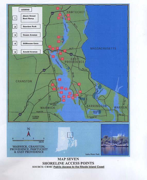
17 3. MOORINGS AND MOORING AREAS The vast majority of moorings within Cranston s jurisdictional waters are commercially operated by the Rhode Island and Edgewood Yacht Clubs. The Rhode Island Yacht club has 55 such moorings and the Edgewood Yacht Club has 65. The two clubs moorings are located in separate fields (see map 6) which can be geographically defined as follows. Edgewood Yacht Club From Northing/Y: Easting/X: to Northing/Y: Easting/X: to Northing/Y: Easting/X: to Northing/Y: Easting/X: to Northing/Y: Easting/X: to Northing/Y: Easting/X: Rhode Island Yacht Club from Northing/Y: Easting/X: to Northing/Y: Easting/X: to Northing/Y: Easting/X: to Northing/Y: Easting/X: The mooring field at the Edgewood Yacht Club runs in a north/south direction and is located in the waters just to the east of the Yacht Club s building in docks. The Edgewood Yacht Club is located at the end of Shaw Avenue off of Narragansett Boulevard. The mooring field at the Rhode Island Yacht Club runs in a north/south direction and is located in the waters to east of the break water at Rhode Island Yacht Club. The western edge of the mooring field abuts Rhode Island Yacht Club s break water. The northern tip of the mooring field is located in front of the Rosedale condominium complex. The Rhode Island Yacht Club is located at the end of Ocean Avenue off of Narragansett Boulevard. While RIGL Ch authorizes the City of Cranston to issue permits for the placement of moorings in the public waters within its jurisdiciton, the City has not exercised this authority and issued permits. Nonetheless, in addition to currently authorized moorings assoicated with marinas a number of moorings have also been placed in the waters adjacent to Cranston (see Table 1). A plan to either retroactively permit these moorings or order their removal is in this HMP. 4. SHORELINE ACCESS POINTS Table1 - Mooring Inventory Commercial Facility Moorings Pawtuxet Cove Marina 0 Port Edgewood Marina 1 Rhode Island Yacht Club 55 Edgewood Yacht Club 65 Pawtuxet Athletic Club 0 Unknown ownership 16 Private/Municipal 0 Total 137 a. Shoreline access points or public rights of way (ROWs) are defined as pathways that provide access to and from the City's shoreline. Other ROWs may include city-owned parks, beaches, boat ramps, conservation areas, and overlooks. The following shoreline public access points derived from the guidebook Public Access to the Rhode Island Coast include the three CRMC designated ROWs in Cranston (Also see map 7). 16
18 1. Aborn Street Boat Ramp - Located off Broad Street, the Aborn Street Boat Ramp is a recently rehabilitated concrete ramp, which is usable only at high tide. Parking for this access point is located at the parking lot on Commercial Street for 20+ cars. (CRMC desogmatopm #K-2) 2. Stillhouse Park - Located at the southern end of Narragansett Boulevard, Stillhouse Park is a 2.6 acre grassy area overlooking the Rhode Island Yacht Club, Stillhouse Cove and Providence River. This site has a boat ramp, but due to adverse site conditions it is only usable at extreme high tides. 3. Arnold Avenue - Located at the foot of Arnold Avenue, this ROW is composed of a small landscaped area with a chain link fence on top of a concrete sea wall. The access point offers a panoramic view of the Providence River and a pleasant lunching spot. 4. Ocean Avenue Located next to the RI Yacht Club, this ROW offers a small beach accessible by five stone steps in the concrete sea wall. The beach area is only usable during low tide. 5. Seaview Park - Located at the foot of Seaview Avenue, the park offers residents a picnic table, park benches, a bike rack, and scenic views of Pawtuxet Cove and the Providence River as well as shoreline access. The area is enclosed on three sides with a three rail wooden fence. (CRMC designation #K-3) 6. Aborn Street (southside) A City parcel of land bounded on the north by Aborn Street, the east by the Pawtuxet Cove, and the west by Bridge Street. This ROW provides pedestrian access from Aborn and Bridge Streets to Pawtuxet Cove by means of a 4 wid strip approximately 50 in length along its eastern boundary. (CRMC designation #K-1) Although the above mentioned ROWs are truly assets to the City and the State as a whole, they are limited in their usability. The primary limiting factor being the availability of public parking. b. State Parks/Launching Area: Currently there are no state parks or boat launching areas located within Cranston s harbor area. 5. OTHER AREAS While the coastal waters adjacent to the City of Cranston currently support significant recreational boating activities and shoreline public areces, there are currently no other significant uses of these resources. Public beaches are currently lacking and windsurfing, swimming, and other water dependent activities that occur at numberous other locations in Rhode Island are not amont the current uses of the City s Coastal resources. 6. MUNCIPAL SHORELINE ZONING The City s Zoning Ordiance does not designate the costal area as a special zoning district. Land located in the coastal areas are zoned as follows (See map 8): TABLE 3 ZONING CLASSIFICATIONS Districts Residential A-12 Residential A-6 Residential B-1 Intended Primarily for the Use of Single-family dwellings on lots of minimum areas of twelve thousand (12,000) square feet. Single-family dwellings on lots of minimum areas of six thousand (6,000) square feet. Single-family and two-family dwellings. 17
19 Residential B-2 Commercial C-3 Industrial M-2 Open space S-1 Educational Intuitional EI Single-family, two-family and multi-family dwellings. General business. General industry. Uses containing high proportion of open space or natural character. Institutions of Higher Education E. Natural Resource Areas 1. WILDLIFE AND/OR CONSERVATION AREAS a. Reserves: The only significant waterfront conservation areas within the City are the coastal wetlands at Stillhouse Cove. These wetlands have been specifically designated for preservation by the CRMP Sec and are highly valued due to their uniqueness within the urban environment of the Providence Metropolitan Area. b. Areas Identified by Studies or Programs: See comments on removal of dam at the Pawtuxet River in section below. c. Areas of Intensive Scientific Research: There are no areas of intensive scientific research located within the City of Cranston. 2. RECREATIONAL AND COMMERCIAL FISHING Soft-shell (steamer) clams and quahogs are abundant in Cranston s jurisdictional waters. However, these waters are closed to shellfish harvesting and there are no commercial fishing facilities located on Cranston s waterfront. Pollution problems from the City of Providence as well as local pollution sources make it unlikely that they will be reopened in the near to long-term future. These same concerns also severely limit the amount of recreational fishing that is undertaken in the City s tidal waters. There are no anadromous fish runs and no known spawing areas within Cranston. However, the possiblibily of removing a dam at the mouth of the Pawtuxet River is currently being studied. If the dam is removed, a significant portion of the Pawtuxet River will be reopened as an anadromous fish run and as a spawning area for shad and herring. 3. BIOLOGICAL HABITATS a. Submerged Aquatice Vegetation: There are no areas of submerged aquatic vegetaion within Cranston s coastal area. b. Intertidal Flats: Cranston has one title flat within it costal waters. Located at Stillhouse Cove, this intertidal flat abuts a coastal tidal marsh and is exposed as the tidal marsh drains during low tides. [See mp 1] c. Tidal Wetlands: Coastal tidal marshes are primarily found along the shore of the City from Stillhouse Cove Park north to and beyond the Edgewood Yacht Club. This condition also exists in some areas south of the Rhode Island Yacht Club and in the northern section of the Pawtuxet Cove. The Stillhouse Cove coastal wetland is perhaps the most valuable. 18

20
21

22

23
24 CHAPTER III ISSUES, GOALS, POLICIES AND RECOMMENDATIONS The following sections address the issues, goals, policies, and recommendations identified through the harbor management planning process. Issues are treated as items of concern where as goals are the desired outcomes. Policies and recommended actions are those positions or courses of action that if taken lead to the accomplishment of a goal or the resolution of an issue. A. Issues During the recent past, an increased in pleasure boating has prompted the expansion of marinas, waterrelated businesses and increased use of Cranston's waters. Due to the increased popularity of boating, many problems associated with the waterfront have surfaced. The City s waterfront faces a wide spectrum of issues ranging from problems with water quality through public access to the shoreline. Based CRMC regulations and public input the HMP Committee identified eight major issues which must be addressed within the HMP. These issues are: MOORINGS WATER QUALITY \ ENVIRONMENTAL PROTECTION INTERCITY COORDINATION / ENFORCEMENT PUBLIC ACCESS SAFETY AND HARBORMASTER DUTIES JURISDICTIONAL BOUNDARIES WITHIN PAWTUXET COVE STORM PREPARDNESS REDEVELOPMENT OF FIELDS POINT B. Goals Using the information obtained in the issue identification section, the City s HMP Committee developed goals for the use, preservation, and development of the City's waterfront. In establishing these goals, the HMP Committee considered the relationship between natural coastal resources, commercial facilities, and the surrounding residential community. The goals are long term and reflect consideration for the future preservation and development of the waterfront. C. Policies and Recommended Actions Comprehensive planning is one method for anticipating the future requirements of the harbor areas. By implementing a comprehensive HMP, a community sets the policy framework for preserving its waterfront resources, prioritizing traditional water-dependent activities and determining the appropriate amount and location of new water-dependent developments. The City s HMP is a policy document that includes enforceable ordinances. This plan balances land use activities with the many water use activities of the City by establishing policies for the use of its shore areas. This chapter delineates the policies and actions intended to be taken by the City in order to achieve the broad goals stated in this chapter. Those items that are listed as "Recommended Actions" are intended to provide points of departure for future review and consideration. These items are not meant to be established within this report as policies for implementation without completion of further study. 1. MOORINGS Issues: In that the City has not until now adopted and enacted a Harbor Management Plan and Ordinance, the City s efforts to manage/regulate boating activities within its coastal areas have been less than adequate. This has lead to the following issues regarding mooring activities. 23
25 a. Capacity The capacity of Cranston s waterfront to accommodate moorings is unclear. The area s status as currently closed to shellfishing calls into question the use of the National Shellfish Sanitation Program s methodology for determining appropriate mooring densities within Cranston s waters. Accommodation of other waterborne uses and water-related land uses must be considered. b. Distribution There are currently 121 moorings managed by marinas or yacht clubs. There are currently 16 moorings of unknown ownershp. As the City has not issued permitsd for these moorings they are assumed to be unauthorized and may or may not be associated with riparian property. c. Location Prior to this HMP there was no City policy regulating the location of moorings in Cranston waters. Prior to this HMP there was a lack of coordination and supervision in the placement of moorings within City waters. At this time, the City has not asserted jurisdiction over the location or placement of moorings. There no City adopted map that identifies where ripirian moorings and mooring fields [public and commercial] should be allowed to locate/expand. d. Safety and Security The level of safety provided by existing moorings is unknown due to a lack of a City specifications for required tackle and a lack of inspection standards. Prior to this HMP the City had no means to identify what type and quality of tackle was in use, how long it had been on the bottom and how much longer the equipment could be expected to remain viable. e. Administration There was no administrative framework on permitting, record keeping, schedule of fees, criteria for the issuance of public moorings and removal of illegal moorings prior to this HMP. Physical and financial resources designated to the Harbormaster are very limited. Goals and Policies: a. Capacity Provide the maximum safe and practicable mooring capacity for existing and potential future activities within designated mooring areas, while reserving adequate channels, fairways, anchorage and open space. Identify potential areas for the future location and expansion of mooring fields specifically at Fields Point. Prioritize short and long term mooring needs for the City. Develop a method using water depth, availability of parking and launching facilities, navigational setbacks and field densities as criteria for determining capacity. b. Distribution Establish a public mooring field and formalize a policy for allocation to vessel owners of no greater than 3:1 resident to non-resident. Develop minimum standards for the proper location and distribution for public mooring fields. Allocate public mooring spaces among all user groups consistent with the CRMC Harbor Management Planning Guidelines. 24
26 Establish a policy for allocating publicly managed recreational moorings between residents and non-residents to provide equitable and efficient allocation of available public mooring space to residents and non-residents consistent with the CRMC requirement of no greater than 3 resident sto 1 non-resident. Establish a policy to equitably accommodate commercial moorings as well as recreational moorings. Should a federal mooring area or anchorage be established, establish a policy consistent with the ACOE open to all on an equal basis policy. Establish a mooring permit waiting list to be managed by the City Harbormaster. c. Location Attain jurisdiction over placement of moorings through passage and implementation of regulations authorizing the Harbormaster to carry out the City s mooring management plan in a manner consistent with CRMC s Coastal Resoucrect Management Program.. Establish a municipal mooring fields with 2 or 3 transient guest moorings. Develop and maintain a map of existing and proposed mooring areas. Said mooring areas to be located via GPS and tied into the State s coordinate system. Provided the necessary ordinances, staff, and resources to manage the mooring fields. For public moorings said management shall include: keeping an accurate count, the precise location and waiting list for moorings and to require that moorings be allocated via said waiting list. Establish an ordinance requiring that all moored vessels (except riparian) be located within CRMC approved mooring area perimeters. Establish an ordinance prohibiting the placement of unregistered moorings in the City s waters. d. Siting, Safety and Security Establish regulations that will address but not be limited to: minimum setback standards for present and future mooring fields, mooring tackle specifications, mooring inspections, illegal abandoned moorings, lessee responsibilities and liability for maintenance of public moorings. Establish and maintain a City log of registered public moorings including information on age of mooring tackle, last inspection, maintenance done on tackle, size of boat. Establish a policy for forfeiture of non-renewed moorings. Prohibit by ordinance the locating of commercially managed moorings (i.e. rented at market values) in Federal navigation projects. Prohibit by ordinance water skiing and swimming in designated channels, fairways and mooring areas. Establish an ordinance to require setbacks from mooring fields to prevent moorings from interfering with access to fairways and channels. Setback limits from riparian moorings and shoreline public rights of ways shall be sufficient to allow ingress and egress and prevent interference with the exercise of private and public right in these areas. Mooring areas shall be setback at least three times the US Army Corps of Engineers authorized project depth from federal navigation projects. Require by ordinance that all new and significantly expanded mooring areas be sited so as not to obstruct access to public recreation areas, conservation ares and shellfish manaagement areas and triditional fishing grounds should any be designated by the CRMC within the City s coastal waters. Require by ordinance that all new and significantly expanded mooring fields be sited to ensure that tides and currents aid in flushing the mooring area. Require by ordinance that all new and significantly expanded mooring areas be sited to avoid adverse effects on water quality. Require by ordinance that all new and significantly expanded mooring areas be sited to avoid adverse effects to fish/shellfish resources. 25
27 Require by ordinance that all new and significantly expanded mooring areas be sited to avoid adverse effects to wetlands. Require by ordinance that all new and significantly expanded mooring areas be sited to avoid adverse effects to submerged aquatic vegetation. Require by ordinance that all new and significantly expanded mooring areas be sited to avoid adverse effects to other aquatic habitat areas no noted above. e. Administration Implement a mooring registration process for public moorings with schedule, fees and waiting lists. Implement a Harbor Management Ordinance and commit sufficient resources to its implementation. Cranston s Harbormaster shall keep an updated list of all mooring holders within City waters, whether they are publicly managed, commercial, or riparian moorings. Establish a formal waterfront directory. Establish an ordinance to ensure that mooring areas are adequately serviced by pump out facilities that are maintaned and accessible.. As noted above, there are three federal navagation projects within Cranston s coastal waters. It is pocilcy of the City that these areas are accessible an available to all on equal terms. Implementation Actions: a. Capacity Create a Harbor Management Commission as a standing committee which would determine the appropriate timing and locations for future public and private mooring fields. Clarify and confirm with RIDEM the appropriate methodology for mooring capacity determination. Draft a mooring growth plan that accommodates future demand while ensuring sufficient distance from channels and fairways for safe passage of all vessels. b. Distribution Develop and impliment plan that will locate existing unauthorized moorings, determine ownership and retroactively permit the moorings or to order their removal. Pursue the development of additional public mooring spaces where sufficient water depth and accessibility allow. c. Location Initiate negotiations with Fields Point property owners to incorporate marina activities into development plans when appropriate. Look into acquiring Federally-owned property at Fields Point for waterfront accessibility. Draft and implement an official mooring management plan for Cranston waters. Map the location of all moring field using GPS and tie said map into the sates coordinate system. d. Safety and Security Establish minimum mooring tackle standards for all vessels. Phase in over three (3) years. Institute formal record keeping of all mooring maintenance activities. Require liability insurance for all public mooring users. e. Administration Draft and enact a Harbor Management Ordinance in which all mooring regulations and other harbor management requirements are located. Empower Harbormaster with management responsibility for future public moorings and to impliment the goals and policies identified above. 26
28 Provide Harbormaster with sufficient resources to carry out mooring management activities. Dedicate a portion of mooring fees for the harbormaster salary and the maintenance a boat. Research and analyze the State of Rhode Island's boat registration reimbursement program and other funds that could be allocated to the City. 2. WATER QUALITY \ ENVIRONMENTAL PROTECTION: Issues: a. The increased interest in pleasure boating has prompted the expansion of marinas, waterrelated businesses and increased use of Cranston s waters. This present level of use may adversely affect the water quality and quality of life along the City s shoreline areas. b. Cranston s waters suffer from severe pollution problems most of which are regional in nature. c. As recognized by the State s CRMP moorings can be significant sources of non-point source pollution (NPSP). d. The existing shellfish resources, which serve as a brood stock, must be protected. e. Cranston s waterfront is the site for coastal tidal marshes which must be protected from the impacts created by more intense use of the land and water. The degradation of Stillhouse Cove coastal wetlands by infiltration of phragmites is an important issue because the area is Cranston s only waterfront park. The City was recently awarded a large grant to restore the coastal wetlands within Stillhouse Cove. f. Historically, improperly maintained septic systems which serviced housing located within the City s coastal area have failed. In order to address this problem, the City constructed a sewerage pump station at the end of Sea View Avenue which allowed houses that were on septic systems to be connected to the City s sewer system. Based on available date, there are now less the 12 houses that have septic systems which may impact the coastal waters. g. Historically, runoff into the Pawtuxet River has been a major contributor of non-point source pollutants of Pawtuxet Cove. This issue is being addessed as the City complies with the requirements of the Clean Water Act. Under said requiremts, stormwater runoff from developments will be treated through best management pratices prior to release. h. Pumpout facilities are located at each of Cranston s four yatch clubs/marinas (Port Edgewood Marina, Edgewood Yatch Club, Rhode Island Yatch Club and Pawtuxet Cover Marina.). (See map 8) Use of these pump out stations are not restricted to shipyard/marina members. These are open to the general public free of charge. In addition to the existing facilities, Cranston has arranged to have East Providence s mobile pumpout facilty provide services in Cranston as needed. Use of East Providence s mobile pumpout facility can be accessed through the Cranston Harbor Master. For a vessel requiring regular serve, the Harbor Master can arrange for scheduled pump outs through a seasonal contract. For as needed service, a vessel owner can contact Cranston s Harbor Master and he will schedule a pump out through the East Providence Harbor Goals and Policies: a. To strive towards the improvement of water quality and the protection of natural resources along the City s coastline and in the Pawtuxet Cove by adopting policies and programs to address pollution generated by recreational boating, non-point source pollutants, and shore side developments and activities. 27
29 b. To maintain, and where possible, improve the water quality of Cranston s waters in conjunction with appropriate state and federal agencies and programs c. To implement regulations authorizing the Harbormaster to visually inspect all vessels to determine if USCG approved marine sanitation devices are in proper working order. d. To protect the existing shellfish brood stock through the regulations of land use and water use. Significant changes in mooring fields, dock facilities or other water uses shall be evaluated for potential impacts to the brood stock. e. Complete the restoration of Stillhouse Cove s coastal wetlands. f. Create outreach program to inform boaters of the availability and location of pump out facilities in Cranston. g. To educate boaters on NPS pollution and boating related best management practices (BMP). h. To work with the marinas to develop and implement State approved NPSP management plans. i. To work with marinas/yacht clubs and the general boating community to insure the proper disposal of inorganic wastes. Implementation Actions: a. Develop and implement a public education program directed at waterfront property owners and commercial and recreational boaters on the dangers of water pollution by land runoff, lawn care chemicals and fertilizers, failing ISDS and other non-point pollution sources. b. Study the impacts to water quality caused by existing and proposed treatment plants and other shoreline land uses. c. Develop an informational handout for boaters using Cranston waters which describe the rules and regulations of the Harbor Management Ordinance as well as listing the location of pump-out facilities and other boating services. d. Acquire and distribute State pump out maps to use as an educational tool to boaters. e. Monitor the remaining residential septic systems located within Cranston s coastal area and establish a program which would encourage connection of these residences to the City s sewer system. f. Sponsor an annual work shop with the City s four marinas/yacht clubs to encourage participation in CRMC s Clean Marina Program. As part of said workshop, distribute CRMC s materials on the program (RI Clean Marina Guide Book, RI Clean Marina Certification and RI Clean Marina Pledge). g. Sponsor an annual work shop with the City s four marinas/yacht clubs to encourage the four marinas/yacht clubs to develop and implement an operation and management plan to minimize pollution. As part of said work shop, distribute CRMC s materials on operation and management plans (Operations and Maintenance Guide for Marinas and Environmental Guide for Marinas), h. Incorporate into the City s Harbor Management Ordinance a provision which restricts boating activities areas where there is shallow-water habitat in order to decrease turbidity and minimize 28
30 physical destruction of said habitats. As part of said ordinance, grant the Harbor Master the power enforce said restrictions. i. Develop a disposal program to address the issue of inorganic materials including waste oil, plastics, trash, paint and varnish. In addition, a disposal site that is convenient to recreational and commercial boaters will also be explored. 3. INTERCITY COORDINATION / ENFORCEMENT Issues: a. The City of Cranston shares water boundaries with the City of Providence, East Providence and Warwick. Each city has different regulations and enforcement procedures. b. The southwest portion of Pawtuxet Cove lies within the City of Warwick creating a potential problem with the jurisdiction of the Cove. c. The southern portion of Fields Point, approximately 50 acres of the total 210 acres, is located in the City of Cranston. Future development of this property will require inter-city coordination with the City of Providence. d. The Pawtuxet River, which flows through the City of Cranston, the City of Warwick and the Town of West Warwick, is a significant contributor to the pollution problem in Pawtuxet Cove. Coordination between the three municipalities is needed in order to reduce this pollution problem. Goals and Policies: a. Pursue a working relationship with the City of Warwick in order to coordinate activities within the shared jurisdiction of Pawtuxet Cove. b. Pursue a working relationship with the City of Providence in order to coordinate activities at the Fields Point site. c. Pursue a working relationship with the City of East Providence to establish and coordinate enforcement of the water boundaries that they share. d. Negotiate Memoranda of Understanding with the City of Warwick, the City of Providence and the City of East Providence on the mutual enforcement of harbor rules and regulations. e. e. Propose a reciprocal agreement with the adjacent cities of Warwick, Providence and East Providence, in which there shall be one, nonvoting, ex-officio member of each community's Harbor Management Committee sitting on the others Harbor Management Committee. f. Ensure that the Cranston Harbormaster maintains effective communication with the harbormasters of the surrounding cities. g. To work with the City of Providence, Johnson and Wales University and Save the Bay to coordinate waterfront development along the southern shore of Fields Point. Implementation Actions: a. Coordinate harbor safety and enforcement patrols with the Cities of Providence, East Providence, and Warwick per section of the RI General Laws. b. Create and periodically update a file containing appropriate harbor plans, ordinances or other documents relating to the waters and waterfront of nearby communities. c. Participate, when possible, in public meetings which occur in the nearby cities and towns pertaining to the waters and waterfront of the nearby communities. Participate in design and construction of Fields Point waterfront development. 29
31 e. Provide proper equipment and financial support for Harbormaster to communicate freely with Harbormasters of neighboring communities. 4. PUBLIC ACCESS Issues: Within the City of Cranston it has been determined that: a. Access to the shore is not only an important public amenity but also an inherent right guaranteed to each and every citizen by the Constitution of the State of Rhode Island. b. The City s short shoreline of only 4 miles and large population of 79,269 (2000 US Census), places added importance and burdens on the limited number of State designated ROW s that currently exist within the City. c. Parking facilities and the associated amenities at the three existing Sate designated ROW s are in need of improvement and in certain cases are inadequate. d. The number of functional public boat launching facilities are limited and currently there are no publicly accessible municipal mooring opportunities within the city. e. Opportunities for expanding Cranston s public access points, launching facilities and municipal moorings, although limited, do exist but have not been sufficiently explored. f. The City is committed to preserving, protecting, and where possible, establishing public access to the water. Inventory of CRMC ROW s CRMC has investigated 6 potential ROW s in the City for the purpose of providing public access to the State s tidal areas. Three have been formally designated by CRMC as public rights-of-way to the shore, Regarding the other three, the CRMC found a lack of evidence sufficient to designate them as rights-of-way. The outcome of the CRMC review of the six proposed rights-ofway in Cranston follows: STREET DESIGNATION ROW- DESIGNATION NO. Aborn Street (south side) K-1 Aborn Street (westerly side) K-2 Off Fort Avenue Insufficient Evidence Off Seaview Avenue Insufficient Evidence Seaview Avenue (west side) K-3 Seaview Avenue (east side) Insufficient Evidence CRMC s Public Access to Rhode Island s Coasts provides the following descriptions of Cranston s ROW s ABORN STREET BOAT RAMP: A concrete ramp is located off Broad Street, at the end of Aborn Street. However, it is usable only at high tide, because the entire cove is navigable only at high tide. Although no parking is permitted in the immediate area, there is parking for more than 20 cars at the nearby city-owned Commercial Street parking lot. CRMC ROW#: K-1, K-2 31
32 SEAVIEW PARK: Located on a cul-de-sac at the end of Seaview Avenue, this small park overlooks historic Pawtuxet Cove. The area is enclosed on three sides with a three-rail wood fence and has a picnic table and park benches. There is no parking on the cul-de-sac. CRMC ROW#: K-3 Trash receptacles OCEAN AVENUE: At the foot of Ocean Avenue, next to the Rhode Island Yacht Club, five steps in a concrete seawall lead to a beach that is accessible only at low tide. Scenic view STILLHOUSE COVE: A grassy strip at the southern end of Narragansett Boulevard overlooks the Rhode Island Yacht Club, Stillhouse Cove, and the Providence River. There is an unmarked asphalt boat ramp in poor condition leading to the Providence River. The ramp is situated on a muddy, rocky shore and is usable only at extreme high tides. The City plans to construct a concrete, 15-foot-wide concrete ramp by No on-street parking is available. Picnicking, wildlife observation ARNOLD AVENUE: Arnold Avenue ends in a small grassy area. In spite of a chain link fence on top of the concrete seawall, this is a pleasant spot to bring a lunch and enjoy the view of the river. ABORN STREET (southside): A City parcel bounded on the north by Aborn Street, the east by the Pawtuxwt Athletic Club, the south by Pawtuxet Cove, and the west by Bridge Street. This ROW provides pedestrian access from Aborn and Bridge Streets to Pawtuxet Cove by means of a 4 wide strip approximately 50 in length along its eastern boundary. (CRMC ROW #K-1). Goals and Policies: a. Preserve, protect and enhance existing public rights-of-way to the tidal waters of the City. b. Support the designation and appropriate marking of additional CRMC waterfront rights-of-way. c. Encourage the provision of public access amenities at new waterfront developments. d. Designate municipal paper streets as potential new ROWs. e. Designate easements as potential new ROWs. f. Designate drainage outefalls as potential new ROWs. g. Designate duried cables as potential new ROWs. h. Foster the development of a public recreational facility in the Fields Point vicinity that would provide adequate vehicle parking, boat launching facilities and access to a potential municipal mooring field targeted for the area. i. Support educational outreach efforts designed to raise awareness of existing public access opportunities. Implementation Actions: a. Develop and implement a maintenance program for all municipally owned rights-of-way. Program elements should focus on upkeep of existing landscaping, trash removal and equipment/public amenities repair. 32
33 b. Develop a prioritized list of improvements for existing public access sites. General considerations should include the provision of lighting, trash receptacles, directional and educational signage and public seating areas. Other specific recommendations are as follows: Aborn Street Boat Ramp CRMC ROW K-1 & K-2 Install better signage to direct users to appropriate vehicle and trailer parking areas. Construct a vessel staging area in the vicinity of the ramp so that boaters have a place to temporarily secure their vessels while parking. Support dredging of Pawtuxet Cove to provide adequate water depth at the ramp. Arnold Ave Remove six-foot chain link fence currently preventing shoreline access and if necessary, replace with wooden or steel guardrail. Install bicycycle amenities to enhance the site s use as a picnic area. Stillhouse Cove - Stabilize erosion along Narragansett Boulevard by constructing a stone rip-rap revetment between mean high water and current curb line. - Reconstruct what has come to be known as a boat ramp in such a fashion that it would only be appropriate for the launching of small hand trailered vessels. - Implement wetland restoration plan currently under development by the Natural Resources Conservation Service. - Install bicycycle amenities to enhance the site s use as a picnic area. Seaview Avenue - Install bicycycle amenities to enhance the site s use as a picnic area. c. Produce an educational flyer for distribution to residents of Cranston that describes the City s public access sites and amenities. d. Develop new state designated public access points to the shore at the terminus of all City street right-of-ways that abut the Bay. More specifically, these should include Norwood Avenue, Arnold Avenue and Strathmore Place. e. Pursue the abandonment and acquisition of Assessor Plat 2/4 Lot 115 from the United States Government. The purpose being to a public recreational facility in the Fields Point vicinity that would provide adequate vehicle parking, boat launching facilities and access to a potential municipal mooring field targeted for the area. 5. HARBOR MANAGEMENT COMMISSION, HARBORMASTER DUTIES, AND SAFETY Issues: a. As part of this planning process, the City has drafted a Harbor Master Ordinance and a Harbor Management Ordinance (amending Chapter 2.32 and Chapter of the Code of Ordinances of the City of Cranston) which pertains to the administration of the City s waters and appoints and defines the duties and qualifications of the harbormaster. This ordinance needs to be adopted. b. Due to the increased use and congestion of the Pawtuxet Cove and the City's shoreline, boating and navigational problems may worsen. c. The presence of derelict docks and abandoned vessels along the City's shoreline create potential hazards to navigation. 33
34 Goals and Policies: a. To develop and implement a Harbor Management Ordinance which will set forth the harbormaster's qualifications, duties and authority over harbor regulations (See Appendix F). b. To create and implement boating regulations which will protect the health, safety, and welfare of the boating public and preserve coastal resources. c. To create a permanent Harbor Management Commission to serve in an advisory capacity on all future issues regarding Cranston s coastal waters and development along its shore. d. To provide a budget which will provide adequate funds and facilities to manage the City s harbor and coastal waters. e. To require the harbormaster and any assistants to be trained in CPR, basic first aid, and all certified boat safety courses offered by the state's Division of Boating Safety. f. To develop and adopt no wake zones which will ensure the safety of the boating public and the public at large. g. To identify and establish a program for removal of derelict docks, abandoned vessels, and other dangerous harbor structures. h. To ensure that all land use actions such as proposed zoning amendments and requests for variances, special permits, or other land use permit which will impact the City s coastal area are submitted to the Harbor Management Commission for advisory comments on any potential coastal impacts to the area. i. To have the Harbor Management Commission review the regulations and draft revisions for consideration by the City Council for enactment. Implementation Actions: a. Actively involve the Harbormaster and the Harbor Management Commission, with the assistance of the state's Division of Boating Safety, and the U.S. Coast Guard Auxiliary, in the organization and participation of safe boating workshops/courses for the public. b. Establish a Harbor Management Commission with oversight of the harbor budget. c. Set up dedicated accounts for the Harbormaster salary, educational purposes and training, and an account to acquire a City boat for the harbormaster. d. To investigate the purchase of a City vessel for the harbormaster. 6. JURISDICTIONAL BOUNDARIES WITHIN PAWTUXET COVE Issues: Insure that Cranston s jurisdictional boundary clearly reflects Marsh Island as being within Cranston. Goals and Policies: a. To forge an agreement with the City of Warwick regarding the jurisdictional responsibilities within Pawtuxet Cove and the jurisdictional boundary line of Marsh Island. 34
35 b. Formalize an agreement with Warwick recognizing (and possibly expanding) the existing mooring field within Pawtuxet Cove. c. Establish an agreed upon number of moorings for both cities within Pawtuxet Cove. Implementation Actions: a. Meet with the City of Warwick concerning the City s boundary and establish an accepted property line along Marsh Island. b. Draft and sign a Memorandum of Understanding with the City of Warwick formalizing this mooring agreement. 7. STORM PREPAREDNESS PLAN a. The entire water area along the shore of Cranston is designated as a Velocity Zone (V-Zone) according to Federal Emergency Management Agency Maps (community panel # ). Velocity zones are defined as coastal high hazard areas subjected to coastal flooding and/or wave action during a 100-year storm. b. Although the entire shoreline of Cranston is designated as a velocity zone, Fields Point and Pawtuxet Neck are areas of greater concern since they would be subjected to greater storm surge due to their perpendicular orientation on the Providence River. Commercial marinas and residential boaters must consider additional precautions when siting moorings and mooring fields and boating facilities in these areas. c. The City of Cranston has drafted the following Storm Preparedness and Hazard Mitigation Elemenent to address these issues as detailed in Apendix C 8. REDEVELOPMENT OF FIELDS POINT Issues: a. One special site must be noted. Located at the northern section of Cranston's waterfront is Fields Point, which is situated on the border of the City of Providence. Cranston's portion of this 210-acre industrial site is about 50 acres, which is presently underutilized as a waterfront resource. b. The 1992 Cranston Comprehensive Plan s objective for development of this underutilized area is one of mixed-use with emphasis on public access to the shoreline and the incorporation of commercial, residential and public use areas designed to take advantage of its location and setting. This objective is discouraged by Cranston's current zoning of the area as General Industry (M-2). c. Since the adoption of the 1992 Comprehensive Plan, the land at Fields Point has been rezoned to Educational Institution and has be developed by Johnson and Wales Univeristy as part of its Harbor Campus. Goals: a. To research the possibilty of the City establishing a mooring field adjacent to the Fields Point property and to establish a mooring field adjacent to the Fields Point property in partnership with Johnson and Wales Univeristy. b. To coordinate these efforts with the City of Providence where possible. 35
36 ACOE Army Corps of Engineers BMP Best Management Practices CRMC Coastal Resources Management Council CRMP Coastal Resources Management Program DEM Department of Environmental Management EPA Environmental Protection Agency FEMA Federal Emergency Management Agency HD Historic District HM Harbor Master HMC Harbor Management Commission HMP Harbor Management Plan ISDS Individual Sewage Disposal System MHW Mean High Water MLW Mean Low Water MSD Marine Satiation Devise NPSP Nonpoint Source Pollution ROWs Rights of Way USCG United States Coast Guard V-ZONE Velocity Zone APPENDIX A: ACRONYMS 36
37 APPENDIX B: APPLICATION FOR MOORING SPACE PERMIT 2008 Applicant s Name Date: Address: Street City State Zip Code Telephone Number: Home Business Vessel Name a. Length: b. Beam: c. Draft: d. Power/Sail: e. Current MSD Inspection Sticker : Vessel Registration Number and State of Issue: Mooring Tackle a. Mushroom anchor weight: b. Chain size and length: c. Date of Last Inspection: d. Name and address of certified mooring inspector DO NOT LEAVE THIS SECTION BLANK. DO NOT WRITE SAME AS LAST YEAR. THIS INFORMATION IS REQUIRED FOR MOORING PERMIT! A COPY OF THE DIVER S CERTIFICATE OR OTHER CERTIFICATION OF INSPECTION ATTESTING TO THE RELIABILITY AND SERVICEABILITY OF THE MORRING TACKLE MUST ACCOMPANY THIS PERMIT APPLICATION! No discharge policy statement: The City of Cranston prohibits the discharge of any sewage or pollutants whatsoever into the waters under its jurisdiction. Every mooring permittee shall be expected to abide by this policy which will be strictly enforced. Please read and sign the following certification statement. 37
38 I am aware that the City of Cranston prohibits the discharge of any sewage or pollutants whatsoever into the waters under its jurisdiction. I will ensure that my guests and I will not discharge sewage or other pollutants into the waters of the City. I grant permission to the Harbormaster or his designated assistant(s) to bard my vessel and or my guest s vessel to inspect marine sanitation devices (MSD) for proper operation and compliance with applicable USCG requirements. I understand any non-compliance with the above is cause for revocation of my mooring permit. Signature and Date Guest Mooring Policy Private mooring holders have the right to have guest vessels use their mooring. The permit holder is responsible for the guest vessel(s), its actions while the guest is utilizing the mooring and for the safe use of the mooring and its tackle. All such guest use of a mooring must be filed with the Harbormaster prior to the guest s utilization of the mooring. Private moorings cannot be rented out. Violation of this policy will result in loss of mooring permit. Mooring Fees. To be determined Payment of Fees: Please make your check payable to Office of the Harbormaster City of Cranston 869 Park Avenue Cranston, RI
39 APPENDIX C : SAMPLE IMPLEMENTATION PLAN Each harbor management plan should incorporate an IMPLEMENTATION PLAN that provides a means of ensuring that goals and recommendations are included in the City s planning process. The Implementation Plan takes major recommendations from the HMP and: 1. Assigns responsibility within local government for each action; 2. Sets a general schedule for accomplishing each action; 3. Suggests applicable new ordinances or regulations, new city administrative services, and estimates costs involved. RECCOMENDATIONS ACTIONS shall be supported with the following data: 1. Action Recommended implementation action; 2. Reference HMP page number, Section, Sub-section, etc; 3. Responsibility The agency, board or commission which is responsible for implementation the action And reporting on progress and completion schedule; 4. Time Line Estimated number of weeks, months, or years to complete the action; 5. Cost Estimate of the approximate cost to complete the action. 39

40 APPENDIX D CRANSTON STORM PREPAREDNESS AND HAZARD MITIGATION PLAN Prepared by the Cranston Harbor Management Planning Committee 2008 FEMA FLOOD MAPS ARE AVAILABLE FOR VIEWING AT THE PLANNING DEPARTMENT, CRANSTON CITY HALL Maps effective as of November 1,
Norwalk Harbor: The Jewel of Long Island Sound. A Presentation by the Norwalk Harbor Management Commission
 Norwalk Harbor: The Jewel of Long Island Sound A Presentation by the Norwalk Harbor Management Commission 2018 State of the Harbor Meeting December 13, 2018 The City of Norwalk in Southwest Connecticut
Living Streets Policy
 Living Streets Policy Introduction Living streets balance the needs of motorists, bicyclists, pedestrians and transit riders in ways that promote safety and convenience, enhance community identity, create
Part 9 Specific Land Uses - Foreshore & Waterway Development
 7 FORESHORE AND WATERWAY DEVELOPMENT This section applies to the following development uses proposed within the foreshore area (defined by LM LEP 2014), and contains Council s specific requirements for
Bicycle Master Plan Goals, Strategies, and Policies
 Bicycle Master Plan Goals, Strategies, and Policies Mobilizing 5 This chapter outlines the overarching goals, action statements, and action items Long Beach will take in order to achieve its vision of
Public Notice U.S. Army Corps In Reply to Application Number CENAB-OP-RMS (NATIONAL HARBOR (FORMERLY PORT Baltimore District AMERICA])
![Public Notice U.S. Army Corps In Reply to Application Number CENAB-OP-RMS (NATIONAL HARBOR (FORMERLY PORT Baltimore District AMERICA])](/thumbs/89/100795623.jpg "Public Notice U.S. Army Corps In Reply to Application Number CENAB-OP-RMS (NATIONAL HARBOR (FORMERLY PORT Baltimore District AMERICA])") Public Notice U.S. Army Corps In Reply to Application Number of Engineers CENAB-OP-RMS (NATIONAL HARBOR (FORMERLY PORT Baltimore District AMERICA]) 88-01361 PN 14-05 Comment Period: January 16, 2014 to
Public Notice U.S. Army Corps In Reply to Application Number of Engineers CENAB-OP-RMS (NATIONAL HARBOR (FORMERLY PORT Baltimore District AMERICA]) 88-01361 PN 14-05 Comment Period: January 16, 2014 to
CHAPTER 6 10/29/2018 Clean Version REGULATING PIERS, WHARVES, MOORING BUOYS, SWIMMING RAFTS AND INFLATABLES ON ROCK LAKE
 1 2 3 4 5 6 7 8 9 10 11 12 13 14 15 16 17 18 19 20 21 22 23 24 25 26 27 28 29 30 31 32 33 34 35 36 37 38 39 40 41 42 43 44 45 46 CHAPTER 6 10/29/2018 Clean Version REGULATING PIERS, WHARVES, MOORING BUOYS,
13 August 14, 2013 Public Hearing
 13 August 14, 2013 Public Hearing APPLICANT/ PROPERTY OWNER: POCAHONTAS LANDING, L.L.C. STAFF PLANNER: Ray Odom REQUEST: Condition Use Permit (Non-Commercial Marina) ADDRESS / DESCRIPTION6: Terminus of
The Town of New Shoreham Harbor Management Plan HMP2018 Draft v1 Public Review 6/28/2018
 The Town of New Shoreham Harbor Management Plan HMP2018 Draft v1 Public Review 6/28/2018 STATEMENT OF PURPOSE... 3 PRIORITY GOALS AND OBJECTIVE... 7 NEW SHOREHAM GENERAL ORDINANCES... Error! Bookmark not
APPROVE A RESOLUTION ADOPTING A COMPLETE STREETS POLICY
 STAFF REPORT MEETING DATE: September 13, 2016 TO: FROM: City Council Bob Brown, Community Development Director Russ Thompson, Public Works Director Patrick Filipelli, Management Analyst 922 Machin Avenue
TOWN OF BRISTOL HARBOR MANAGEMENT PLAN AND HARBOR ORDINANCES 5-Year Update 2011
 TOWN OF BRISTOL HARBOR MANAGEMENT PLAN AND HARBOR ORDINANCES 5-Year Update 2011 Approved by Bristol Harbor Commission: December 6, 2010 Adopted by Bristol Town Council: January 26, 2011 Approved by RI
Corpus Christi Metropolitan Transportation Plan Fiscal Year Introduction:
 Introduction: The Safe, Accountable, Flexible, Efficient Transportation Equity Act: A Legacy for Users (SAFETEA-LU) has continued the efforts started through the Intermodal Surface Transportation Efficiency
TRANSPORTATION NEEDS ASSESSMENT
 TRANSPORTATION NEEDS ASSESSMENT A travel demand analysis was carried out to determine the operational issues and the potential benefit that adding traffic capacity would have on the road network. All the
o n - m o t o r i z e d transportation is an overlooked element that can greatly enhance the overall quality of life for the community s residents.
 N o n - m o t o r i z e d transportation is an overlooked element that can greatly enhance the overall quality of life for the community s residents. 84 Transportation CHAPTER 11 INTRODUCTION Transportation
GONE! Coastal Erosion Happens During Storms! Why Worry About Coastal Setbacks? Goals for Today
 RI Regulatory Setbacks & Buffers: Coastal Zone Management Issues New England Onsite Wastewater Training Program @ URI OWT 155 November 21, 2013 Goals for Today Understand the impacts of storms, coastal
Chapter I: Marine Resources
 NOTE TO READERS: This is a draft of the Kennebunk Comprehensive Plan. The Comprehensive Plan provides us with a description of the town today in a range of categories, and identifies issues and recommendations
MEMORANDUM. Existing Operations. City of Clearwater. Michael Herrman. Date: January 26, Seminole Boat Launch Overview. M&N Job No.
 1509 W. Swann Avenue, Suite 225 Tampa, FL 33606 (813) 258-8818 Fax (813) 258-8525 www.moffattnichol.com MEMORANDUM To: From: City of Clearwater Michael Herrman Date: Subject: Seminole Boat Launch Overview
University of Victoria Campus Cycling Plan Terms of Reference. 1.0 Project Description
 University of Victoria Campus Cycling Plan Terms of Reference 1.0 Project Description The Campus Cycling Plan, a first for the University, will provide a comprehensive and coordinated approach to support
TOWN OF PORTSMOUTH HARBOR MANAGEMENT PLAN
 TOWN OF PORTSMOUTH HARBOR MANAGEMENT PLAN FINAL DRAFT February, 2014 PORTSMOUTH HARBOR COMMISSION PORTSMOUTH PLANNING DEPARTMENT Table of Contents 1.0 - INTRODUCTION... 1 1.1 PLAN PURPOSE... 2 1.2 - PLAN
CITY OF NEWPORT BEACH HARBOR COMMISSION STAFF REPORT
 CITY OF NEWPORT BEACH HARBOR COMMISSION STAFF REPORT Agenda Item No. 2 TO: FROM: SUBJECT: HARBOR COMMISSION Harbor Resources Division (City Manager's Office) Chris Miller, Harbor Resources Supervisor,
Exhibit 1 PLANNING COMMISSION AGENDA ITEM
 Exhibit 1 PLANNING COMMISSION AGENDA ITEM Project Name: Grand Junction Circulation Plan Grand Junction Complete Streets Policy Applicant: City of Grand Junction Representative: David Thornton Address:
Coastal and marine recreation in New England is ingrained in the region s economic and
 RECREATION Coastal and marine recreation in New England is ingrained in the region s economic and social fabric. Recreation on the ocean and coast includes many of New Englanders most time-honored and
31. Rosses Point Mini-Plan
 County Development Plan 2017-2023 Volume 2, Chapter 31 Rosses Point Mini-Plan 31. Rosses Point Mini-Plan Village profile Rosses Point is a coastal settlement located approximately 8 km north-west of Sligo
Page 1. To: City of Durango - Parks and Recreation Advisory Board - Natural Lands Preservation Advisory Board Highland Avenue Durango, Colorado
 Page 1 To: City of Durango - Parks and Recreation Advisory Board - Natural Lands Preservation Advisory Board From: John Norton 2009 Highland Avenue Durango, Colorado Date: October 27, 2014 Regarding: Natural
West Dimond Blvd Upgrade Jodhpur Street to Sand Lake Road
 West Dimond Blvd Jodhpur St to Sand Lake CSS Transportation Project Summary Municipality of Anchorage Project # 05 005 Project Manager: John Smith, P.E. (MOA PM&E) Project Administrator: Julie Makela,
Issues facing this region include the status of the Sluice Creek tide gates, various tidal wetlands, and locations of public access:
 5.6 Guilford Point to Madison Town Line Existing Resources This region extends from Guilford Point to the Madison town line. Named places include Grass Island and the East River. Residential, commercial,
City of Elizabeth City Neighborhood Traffic Calming Policy and Guidelines
 City of Elizabeth City Neighborhood Traffic Calming Policy and Guidelines I. Purpose: The City of Elizabeth City is committed to ensure the overall safety and livability of residential neighborhoods. One
CONNECTING PEOPLE TO PLACES
 CONNECTING PEOPLE TO PLACES 82 EAST BENCH MASTER PLAN 07 Introduction The East Bench transportation system is a collection of slow moving, treelined residential streets and major arteries that are the
CITY OF COCOA BEACH 2025 COMPREHENSIVE PLAN. Section VIII Mobility Element Goals, Objectives, and Policies
 CITY OF COCOA BEACH 2025 COMPREHENSIVE PLAN Section VIII Mobility Element Goals, Objectives, and Policies Adopted August 6, 2015 by Ordinance No. 1591 VIII MOBILITY ELEMENT Table of Contents Page Number
Management of Shellfish Aquaculture and Propagation in Massachusetts Waters
 Management of Shellfish Aquaculture and Propagation in Massachusetts Waters Chris Schillaci Aquaculture and Propagation Project Massachusetts Division of Marine Fisheries Shellfish In Massachusetts Massachusetts
RHODE ISLAND. Foundation. P.O. Box 1465, Coventry, Rhode Island FAX:
 RHODE ISLAND SALTWATER Foundation P.O. Box 1465, Coventry, Rhode Island 02816 401-826-2121 FAX: 401-826-3546 2013 Southern New England Recreational Fishing Symposium April 2, 2013 Radisson Airport Hotel,
NM-POLICY 1: Improve service levels, participation, and options for non-motorized transportation modes throughout the County.
 Transportation PRINCE WILLIAM COUNTY 2008 COMPREHENSIVE PLAN NON-MOTORIZED PLAN CONTENTS Goals, Policies, and Action Strategies Table 4 (Bike Facility Classifications and Descriptions) Table 5 (Bike Facility
CITY OF BLOOMINGTON COMPLETE STREETS POLICY
 CITY OF BLOOMINGTON COMPLETE STREETS POLICY POLICY OBJECTIVE: The City of Bloomington will enhance safety, mobility, accessibility and convenience for transportation network users of all ages and abilities,
RI Regulatory Setbacks & Buffers: Coastal Management Issues
 RI Regulatory Setbacks & Buffers: Coastal Management Issues New England Onsite Wastewater Training Program @ URI OWT 155 - November 29, 2012 James Boyd - Coastal Policy Analyst Photo: October 30, 2012
STONINGTON HARBOR AND WATERS ORDINANCE
 STONINGTON HARBOR AND WATERS ORDINANCE L Jurisdiction The rales and regulations of the Stonington Harbor and Waters Ordinance shall apply to activities occurring within or directly affecting the area within
ACTIVE TRANSPORTATION/NONMOTORIZED TRANSPORTATION
 ACTIVE TRANSPORTATION/NONMOTORIZED TRANSPORTATION BACKGROUND Active transportation, also known as nonmotorized transportation, is increasingly recognized as an important consideration when planning and
ARTICLE III. CERTAIN PUBLIC PLACES* DIVISION 1. GENERALLY DIVISION 2. MUNICIPAL YACHT BASIN DIVISION 3. MANAGED MOORING FIELD
 ARTICLE III. CERTAIN PUBLIC PLACES* *Cross References: Parks and recreation, Ch. 14. Secs. 17-56--17-65. Reserved. DIVISION 1. GENERALLY DIVISION 2. MUNICIPAL YACHT BASIN Sec. 17-66. Mooring. It shall
Solana Beach Comprehensive Active Transportation Strategy (CATS)
") Solana Beach Comprehensive Active Transportation Strategy (CATS) 3.0 Goals & Policies The Solana Beach CATS goals and objectives outlined below were largely drawn from the Solana Beach Circulation Element
Solana Beach Comprehensive Active Transportation Strategy (CATS) 3.0 Goals & Policies The Solana Beach CATS goals and objectives outlined below were largely drawn from the Solana Beach Circulation Element
ADA Transition Plan. City of Gainesville FY19-FY28. Date: November 5, Prepared by: City Of Gainesville Department of Mobility
 ADA Transition Plan FY19-FY28 Date: November 5, 2018 Prepared by: City Of Gainesville Department of Mobility 1.0 INTRODUCTION 1.1 BACKGROUND The federal statute known as the Americans with Disabilities
HARBOR INFRASTRUCTURE INVENTORIES Caseville Harbor, Michigan
 HARBOR INFRASTRUCTURE INVENTORIES Caseville Harbor, Michigan Harbor Location: Caseville Harbor is located at the mouth of the Pigeon River on the east shore of Saginaw Bay, about 17 miles southwest of
HARBOR INFRASTRUCTURE INVENTORIES Marquette Harbor, Michigan
 HARBOR INFRASTRUCTURE INVENTORIES Marquette Harbor, Michigan Harbor Location: Marquette Harbor is located in Marquette Bay on the south shore of Lake Superior, 160 miles west of Sault Ste. Marie, MI and
CFH Boise City Parks and Recreation
 CFH13-00029 Boise City Parks and Recreation Summary The Parks and Recreation Department requests approval of a Boise River System Permit for the repair of ±200 feet of river bank generally located at 5845
5. Pedestrian System. Accomplishments Over the Past Five Years
 5. Pedestrian System Accomplishments Over the Past Five Years The Alamo Area Metropolitan Planning Organization (MPO) and its partner agencies recognize the importance of improving pedestrian mobility.
Chapter 7. Transportation. Transportation Road Network Plan Transit Cyclists Pedestrians Multi-Use and Equestrian Trails
 Chapter 7 Transportation Transportation Road Network Plan Transit Cyclists Pedestrians Multi-Use and Equestrian Trails 7.1 TRANSPORTATION BACKGROUND The District of Maple Ridge faces a number of unique
RESOLUTION NO ?? A RESOLUTION OF THE CITY OF NEPTUNE BEACH ADOPTING A COMPLETE STREETS POLICY
 RESOLUTION NO. 2018-?? A RESOLUTION OF THE CITY OF NEPTUNE BEACH ADOPTING A COMPLETE STREETS POLICY WHEREAS, safe, convenient, and accessible transportation for all users is a priority of the City of Neptune
HARBOR INFRASTRUCTURE INVENTORIES Fairport Harbor, OH
 HARBOR INFRASTRUCTURE INVENTORIES Fairport Harbor, OH Harbor Location: Fairport Harbor is located at the mouth of the Grand River on the southern shore of Lake Erie in the city of Fairport, OH, approximately
Roadway Classification Design Standards and Policies. Pueblo, Colorado November, 2004
 Roadway Classification Design Standards and Policies Pueblo, Colorado November, 2004 Table of Contents Page Chapter 1. General Provisions 1.1 Jurisdiction 3 1.2 Purpose and Intent 3 1.3 Modification 3
Active Transportation Infrastructure Investment A Business Case
 Active Transportation Infrastructure Investment A Business Case In 2016, the Real Estate Foundation awarded the Capital Regional District a $50,000 grant for Shifting Gears: Land Use Change through Active
TOWN OF PORTLAND, CONNECTICUT COMPLETE STREETS POLICY
 TOWN OF PORTLAND, CONNECTICUT COMPLETE STREETS POLICY I. VISION, GOALS & PRINCIPLES VISION To improve the streets of Portland making them safer and more accessible for all users including pedestrians,
Proposed. City of Grand Junction Complete Streets Policy. Exhibit 10
 Proposed City of Grand Junction Complete Streets Policy Exhibit 10 1 City of Grand Junction Complete Streets Policy Vision: The Complete Streets Vision is to develop a safe, efficient, and reliable travel
Executive Summary Route 30 Corridor Master Plan
 Route Corridor Master Plan Project Overview The Route Corridor Master Plan is a coordinated multimodal transportation and land use plan for the entire stretch of Route through East Whiteland Township,
Comments The Plan for Port Whitby
 Comments The Plan for Port Whitby April 24th, 2013 Community Meeting #2 Summary Report Prepared by GLPi April 29th, 2013 1 Introduction The purpose of the Port Whitby Secondary Plan Update, Community Improvement
PROPOSED RULEMAKING GAME COMMISSION
 PROPOSED RULEMAKING GAME COMMISSION [ 58 PA. CODE CH. 141 ] Hunting and Trapping; Prohibited Devices its October 5, 2010, meeting, proposed to add 141.68 (relating to prohibited devices) to specifically
HARBOR INFRASTRUCTURE INVENTORIES Oak Orchard Harbor, New York
 HARBOR INFRASTRUCTURE INVENTORIES Oak Orchard Harbor, New York Harbor Location: Oak Orchard Harbor is located on the southern shore of Lake Ontario at the mouth of Oak Orchard Creek in the village of Point
City of Novi Non-Motorized Master Plan 2011 Executive Summary
 City of Novi Non-Motorized Master Plan 2011 Executive Summary Prepared by: February 28, 2011 Why Plan? Encouraging healthy, active lifestyles through pathway and sidewalk connectivity has been a focus
IMPLEMENTING REGULATIONS OF THE WILDLIFE CONSERVATION LAW. Authorized by the Republic of China Wildlife Conservation Law, amended October 29, 1994.
 IMPLEMENTING REGULATIONS OF THE WILDLIFE CONSERVATION LAW Authorized by the Republic of China Wildlife Conservation Law, amended October 29, 1994. CHAPTER I: INTRODUCTION Section 1. The following regulations
La Crescent Township Zoning Ordinance
 La Crescent Township Zoning Ordinance Table of Contents SECTION 1 ~ PREAMBLE, TITLE, SHORT TITLE AND PURPOSE... 1 0101 Preamble... 1 0102 Title... 1 0103 Short Title... 1 0104 Purpose... 1 SECTION 2 ~
June 25, Re: Camping Platform Permitting (NSGLC )
") June 25, 2013 Curtis W. Smith Director of Planning Accomack-Northampton Planning District Commission P.O. Box 417, 23372 Front Street Accomac, VA 23301 Re: Camping Platform Permitting (NSGLC-12-04-03)
June 25, 2013 Curtis W. Smith Director of Planning Accomack-Northampton Planning District Commission P.O. Box 417, 23372 Front Street Accomac, VA 23301 Re: Camping Platform Permitting (NSGLC-12-04-03)
: AUTHORITY: This ordinance is adopted under the authority granted by Section 30.13(2) and 30.13(3) of the Wisconsin Statutes.
 and 30.13(3) of the Wisconsin Statutes.") 1 2 3 4 5 6 7 8 9 10 11 12 13 14 15 16 17 18 19 20 21 22 23 24 25 26 27 28 29 30 31 32 33 34 35 36 37 38 39 40 41 42 43 44 45 CHAPTER 6 REGULATING PIERS, WHARVES, MOORING BUOYS, RAFTS, AND INFLATABLES
1 2 3 4 5 6 7 8 9 10 11 12 13 14 15 16 17 18 19 20 21 22 23 24 25 26 27 28 29 30 31 32 33 34 35 36 37 38 39 40 41 42 43 44 45 CHAPTER 6 REGULATING PIERS, WHARVES, MOORING BUOYS, RAFTS, AND INFLATABLES
Case Study 3. Case Study 3: Cebu Island, Philippines MPA Network 10
 Case studies of mpa networks Case Study 3: Cebu Island, Philippines MPA Network 10 Location and background Cebu Island in the Philippines lies in the center of the Visayan Islands, known as an area high
City of Pittsfield HARBORMASTER RULES AND REGULATIONS on docks
 City of Pittsfield HARBORMASTER RULES AND REGULATIONS on docks Definitions Dock: Any permanently fixed or floating structure extending from the upland into the water, capable of use for vessel mooring
Lake Tahoe Shoreline Plan. 01 Scope
 Lake Tahoe Shoreline Plan 01 Scope 09.20.2016 1 Brief Description The Shoreline Plan needs a defined scope to focus work efforts and complete the planning process by the end of 2018 (within the existing
CITY OF NAPLES STAFF REPORT
 Meeting of 8/9/17 Variance Petition 17-V5 CITY OF NAPLES STAFF REPORT To: Planning Advisory Board From: Planning Department Subject: Variance Petition 18-V2 Petitioner: Ian & Catherine Delaney Agent: Jeff
Rhode Island Department of Environmental Management Division of Fish and Wildlife American Shad Habitat Plan for the Pawcatuck River
 Rhode Island Department of Environmental Management Division of Fish and Wildlife American Shad Habitat Plan for the Pawcatuck River Prepared by: Phil Edwards, Rhode Island Department of Environmental
The Blue Heron Slough Conservation Bank
 1 The Blue Heron Slough Conservation Bank CONSERVATION BANKING July 19-23, 2010 CASE STUDY SERIES The Blue Heron Slough Conservation Bank (Washington) I. OVERVIEW & BACKGROUND: Location: Snohomish River
CHAPTER 7 ACCESS MANAGEMENT. Background. Principles of Access Management. Hennepin County Transportation Systems Plan (HC-TSP)
") CHAPTER 7 ACCESS MANAGEMENT Background Principles of Access Management Hennepin County Transportation Systems Plan (HC-TSP) Chapter 7 Access Management 7.1 Background Access management has become an important
CHAPTER 7 ACCESS MANAGEMENT Background Principles of Access Management Hennepin County Transportation Systems Plan (HC-TSP) Chapter 7 Access Management 7.1 Background Access management has become an important
Storm Preparedness Plan for Manchester, Massachusetts Issued by the Manchester Harbormaster Department. A.
 Manchester-by-the-Sea Harbormaster Harbormaster 10 CENTRAL ST. MANCHESTER, MASSACHUSETTS 01944-1399 OFFICE (978)526-7832 CELL (978)473-2520 FAX (978)526-2001 HARBORMASTER@MANCHESTER.MA.US. Storm Preparedness
OPEN HOUSE WELCOME Bronte Village Growth Area Review
 OPEN HOUSE WELCOME Bronte Village Growth Area Review Bronte Village is a growth area. Learn more! Introduction Bronte Village is a growth area. What is that? Bronte Village is one of six growth areas identified
CHAPTER 7.0 IMPLEMENTATION
 CHAPTER 7.0 IMPLEMENTATION Achieving the vision of the Better Streets Plan will rely on the ability to effectively fund, build and maintain improvements, and to sustain improvements over time. CHAPTER
Chapter 5 Future Transportation
 Chapter 5 Future Transportation The Future Land Use Plan identifies the desired land use designations. The land uses desired for Crozet depend, in large part, on the success of the transportation system,
Overview. Existing Conditions. Corridor Description. Assessment
 Overview A study of the 23 rd Street corridor was undertaken to document the existing conditions, analyze traffic operations, and recommend remedies for deficient situations Although 23 rd Street is frequently
PUBLIC EXHIBITION OF COASTAL ZONE MANAGEMENT PLAN FOR COLLAROY-NARRABEEN BEACH AND FISHERMANS BEACH
 ITEM 8.3 REPORTING MANAGER TRIM FILE REF 2014/110936 ATTACHMENTS PUBLIC EXHIBITION OF COASTAL ZONE MANAGEMENT PLAN FOR COLLAROY-NARRABEEN BEACH AND FISHERMANS BEACH GROUP MANAGER NATURAL ENVIRONMENT 1
The Sand Beaches of New Hampshire and Maine
 The Sand Beaches of New Hampshire and Maine Beach Preservation and Erosion Control Photographs provided by Joe Kelly and Steve Adams Cover photo: Reid State Park, ME Introduction The sand beaches of New
WHEREAS, the ordinance will not create excessive additional requirements for public facilities and services at public cost.
 ORDINANCE 19-05 AN ORDINANCE OF VALLEY COUNTY, IDAHO, CREATING AN ORDINANCE TO BE ADMINISTERED BY THE VALLEY COUNTY SHERIFF S OFFICE AND TO BE KNOWN AS VALLEY COUNTY WATERWAYS ORDINANCE THAT INCLUDES PAYETTE
New Orleans Municipal Yacht Harbor
 New Orleans Municipal Yacht Harbor Marina Schematic Design Update 601 Poydras St., Suite 1860 New Orleans, LA, 70130 504-648-3560 Post-Katrina Municipal Yacht Harbor: Introduction The MYH was an approximate
Technical Overview: Fisheries Act Amendments
 Technical Overview: Fisheries Act Amendments November 21, 2012 The Assembly of First Nations (AFN) is the political representative body for over 630 First Nations across Canada. As part of its mandate,
F4. Coastal Mooring Zone and moorings outside the Coastal Mooring Zone
 F4. Coastal Mooring Zone and moorings outside the Coastal Mooring Zone F4.1. Zone description This section addresses the provisions relating to moorings in the Coastal Mooring Zone and those outside the
A USERS GUIDE TO MOORINGS IN DARTMOUTH
 A USERS GUIDE TO MOORINGS IN DARTMOUTH This summary is intended as a basic introduction to the procedures, responsibilities, and policies regarding the application for, assignment to, and maintenance of
summary of issues and opportunities
 1 summary of issues and opportunities EXECUTIVE SUMMARY CHAPTER 2: HISTORY - 3: LAND USE This first chapter is an overview of lessons learned from analysis of the existing conditions on El Camino as well
Affects of Tides on Lateral Coastal Access at. Las Varas Ranch. Gaviota, California. Photos Courtesy of California Coastal Records Project
 Affects of Tides on Lateral Coastal Access at Las Varas Ranch Gaviota, California Photos Courtesy of California Coastal Records Project September 18, 2014 Santa Barbara County Trails Council 1 As part
2018 Boat Slip & Mooring Lease Agreement
 BOATER INFORMATION 2018 Boat Slip & Mooring Lease Agreement Boat Owner(s) Name: Phone(s): Contact Email: Boat Name: Make: Registration #: Boat Length: Model: Boat Color: ** A copy of your current, valid
Hunting, Fishing, Recreational Shooting, and Wildlife Conservation Opportunities and Coordination with States, Tribes, and Territories
 THE SECRETARY OF THE INTERIOR WASHINGTON ORDER NO. 3356 Subject: Hunting, Fishing, Recreational Shooting, and Wildlife Conservation Opportunities and Coordination with States, Tribes, and Territories Sec.
CITY OF DEEPHAVEN CHAPTER 9 TABLE OF CONTENTS. Auxiliary Watercraft Owner of Watercraft or Aircraft. Subd. 10. Lease Subd. 11.
 CITY OF DEEPHAVEN CHAPTER 9 TABLE OF CONTENTS CHAPTER 9. CITY WATERCRAFT SPACES 900 CITY WATERCRAFT SPACES 900.01 Definitions Subd. 1. Subd. 2. Subd. 3. Subd. 4. Subd. 5. Subd. 6. Subd. 7. Subd. 8. Watercraft
Coastal Wetlands Protection Act. Fisheries Management, Marine Sanctuaries and Closures
 , STATE AND LOCAL AUTHORITY FOR MARINE PROTECTION (2014). MISSISSIPPI 1 State Authority for Protection Summary of State Authorities Mississippi has several options for conserving marine habitat; however,
Ann Arbor Downtown Street Plan
 1 Ann Arbor Downtown Street Plan Public Workshop #1 We know that. 2 Public right-of-way (streets, sidewalks, and alleys) make up 30% of the total District area of downtown. Streets need to provide mobility
Lake Tahoe Shoreline Plan. 05 Policy Topic: Piers- Fish Habitat, Design, and Scenic Issues
 Lake Tahoe Shoreline Plan 05 Policy Topic: Piers- Fish Habitat, Design, and Scenic Issues 07.20.2016 1 Brief Description There are 768 piers located along the shoreline of Lake Tahoe. Approximately 43
TRAVEL PLAN: CENTRAL EUROPEAN UNIVERSITY CAMPUS REDEVELOPMENT PROJECT TRAVEL PLAN. Central European University Campus Redevelopment Project.
 TRAVEL PLAN Central European University Campus Redevelopment Project Page 1 Table of Contents Introduction... 3 Background... 7 Building Users... 7 Transportation in Community Consultation... 7 Summary
IMPLEMENTATION. Argyll Marine Special Areas of Conservation
 5 5 Argyll Marine Special Areas of Conservation 5.1 Implementation of the Management Plan Implementation of this management plan will be necessary to ensure compliance with the Habitats Directive. Although
The Malaspina Okeover
 Unit 7 Theodosia Inlet Marine Area Substrate Exposure Current Roughness Shoreline Slope Depth Benthic Summer Temp 2.0 sq km Mud 12.5 km Flat Shallow-Photic Warm DESCRIPTION: Theodosia Inlet is the most
AMATS Complete Streets Policy
 AMATS Complete Streets Policy Table of Contents: Section 1. Definition of Complete Streets Section 2. Principles of Complete Streets Section 3. Complete Streets Policy Section 4. Consistency Section 5.
Estimated on-the-ground start and end dates: 1 June October 2018
 A. Applicant Information Name of Organization: U.S. Army Corps of Engineers, Carlyle Lake 801 Lake Road, Carlyle, IL 62231 Contact Information: Robert Wilkins, Operations Manager, (618) 594-2484, Robert.Wilkins@usace.army.mil
2.0 Existing Conditions
 20 2.0 Existing Conditions 2.1 Land Use, Future Growth Patterns, Physical Barriers Geographic Overview Sutter County s land use pattern is characterized by extensive agricultural areas, significant natural
CANDLEWOOD SHORES TAX DISTRICT ORDINANCE GOVERNING USE OF THE CSTD RECREATION AREAS
 BE IT ORDAINED THAT: Section 1 - TITLE: This Ordinance shall be known and may be cited as the Recreation Area Use Ordinance of the Candlewood Shores Tax District (CSTD). Section 2 - PURPOSE: The purpose
AGENDA ITEM NO. 5b HCAOG TAC meeting of May 8, 2014
 Humboldt County Association of Governments Eureka, CA, 95501 AGENDA ITEM NO. 5b HCAOG TAC meeting of May 8, 2014 DATE: May 1, 2014 TO: HCAOG Technical Advisory Committee (TAC) FROM:, SUBJECT: Letters of
Coastal Hazards and Management in North Carolina. Braxton Davis April 14, 2015
 Coastal Hazards and Management in North Carolina Braxton Davis April 14, 2015 Coastal Facts and Figures 320 miles of ocean beaches 12,000+ miles of estuarine shoreline 2 million + acres of sounds, creeks,
Chapter 48 Coastal Waters
 The following Code does not display images or complicated formatting. Codes should be viewed online. This tool is only meant for editing. Chapter 48 Coastal Waters [HISTORY: Adopted by the Town of Cumberland
EXECUTIVE SUMMARY: TRANSIT-ORIENTED DEVELOPMENT IN SMITHS FALLS, ONTARIO; A COMPARISON BETWEEN TWO SITES
 EECUTIVE SUMMARY: TRANSIT-ORIENTED DEVELOPMENT IN SMITHS FALLS, ONTARIO; A COMPARISON BETWEEN TWO SITES Topic and Purpose In 2007, the Mayor of Ottawa s Task Force on Transportation suggested adding a
HARBOR INFRASTRUCTURE INVENTORIES Kenosha Harbor, Wisconsin
 HARBOR INFRASTRUCTURE INVENTORIES Kenosha Harbor, Wisconsin Harbor Location: Kenosha Harbor is on the west shore of Lake Michigan about 54 miles north of Chicago, Illinois. Authority: River & Harbor Acts
New Jersey Coastal Zone Overview. The New Jersey Beach Profile Network (NJBPN) 3 Dimensional Assessments. Quantifying Shoreline Migration
 3 Dimensional Assessments. Quantifying Shoreline Migration") New Jersey Coastal Zone Overview The New Jersey Beach Profile Network (NJBPN) Objectives Profile Locations Data Collection Analyzing NJBPN Data Examples 3 Dimensional Assessments Methodology Examples Quantifying
New Jersey Coastal Zone Overview The New Jersey Beach Profile Network (NJBPN) Objectives Profile Locations Data Collection Analyzing NJBPN Data Examples 3 Dimensional Assessments Methodology Examples Quantifying
RESOLUTION NO A RESOLUTION OF THE CITY COUNCIL OF THE CITY OF MENLO PARK ADOPTING A COMPLETE STREETS POLICY
 RESOLUTION NO. 6123 A RESOLUTION OF THE CITY COUNCIL OF THE CITY OF MENLO PARK ADOPTING A COMPLETE STREETS POLICY WHEREAS, the term Complete Streets describes a comprehensive, integrated transportation
Tulsa Metropolitan Area LONG RANGE TRANSPORTATION PLAN
 Tulsa Metropolitan Area LONG RANGE TRANSPORTATION PLAN Indian Nations Council of Governments August 2005 CONTACTING INCOG In developing the Destination 2030 Long Range Transportation Plan, INCOG s Transportation