31. Rosses Point Mini-Plan
|
|
|
- Steven Hamilton
- 5 years ago
- Views:
Transcription
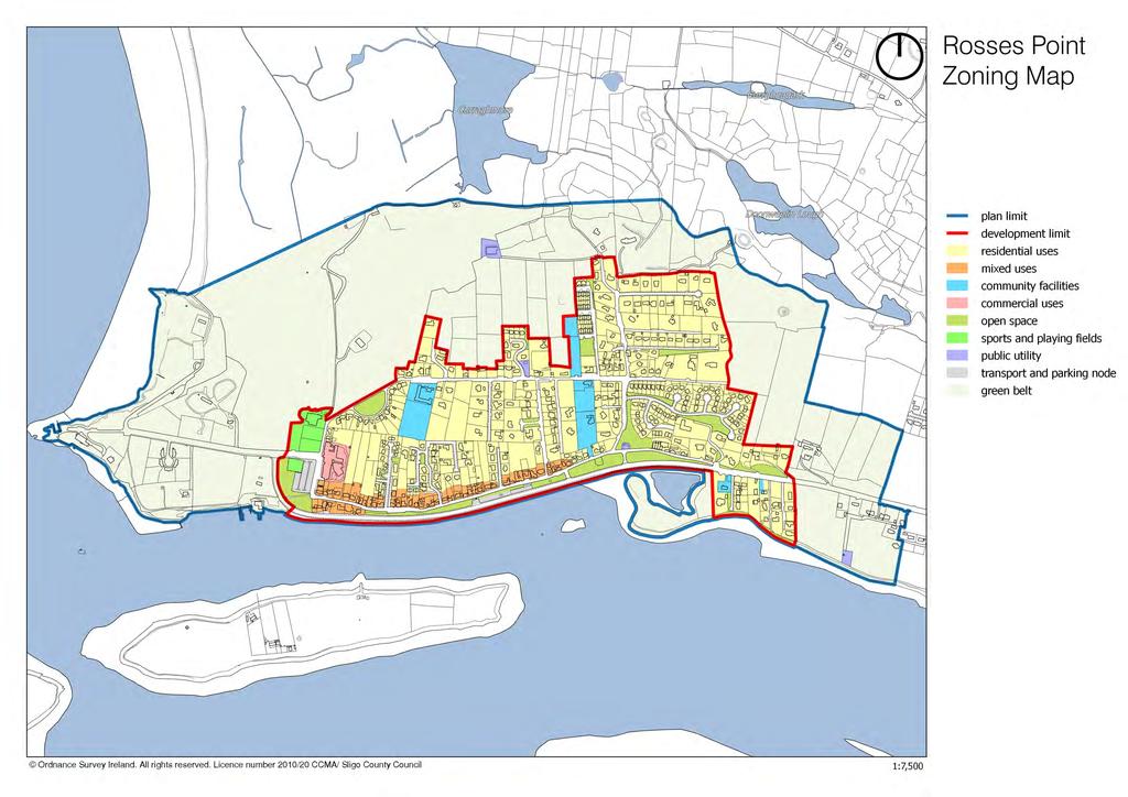
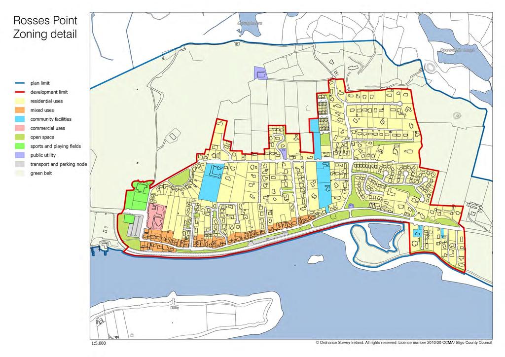
1 County Development Plan Volume 2, Chapter 31 Rosses Point Mini-Plan 31. Rosses Point Mini-Plan Village profile Rosses Point is a coastal settlement located approximately 8 km north-west of Sligo City, accessed via the regional road R-291. The village is situated in a Rural Area under Urban Influence. While the built-up area is on lands classified as normal rural landscape, the surrounding coastal zone is extremely sensitive, with large areas classified as visually vulnerable and sensitive rural landscape. The village is identified as a village sustaining the rural community in the County settlement hierarchy (see Section 3.2 of the CDP). The special tourism function of the village is also highlighted. Rosses Point has a core area defined by a continuous streetscape along a large stretch of the village road, with the remainder consisting of medium-density housing development. The village is surrounded by open rural countryside and the Atlantic Ocean the Cummeen Strand/Drumcliff Bay (Sligo Bay) SAC/pNHA and Cummeen Strand SPA. There is a harbour at the western end of the village and a beach to the north-west. With its long and rich maritime tradition, Rosses Point is unique in the County of Sligo. Over the years, the village had produced many Master Mariners and its connections with the merchant navy continue today. Through the merchant families of Middleton and the Pollexfen, the Yeats brothers formed strong links with the village and referred to it often in their works. The maritime tradition continues today through the facilities for sailing, boating, sea angling, windsurfing, sea kayaking, open water swimming, sea scouting, and the annual International Sea Shanty Festival. Rosses Point is also the base for the RNLI s Sligo Bay Lifeboat Service. Population and housing According to 2011 Census information, Rosses Point had a population of 824 persons (a 5% decrease on the 2006 figure of 872 persons). There was a 13% population increase recorded between the years Residential development in the village is not correlated with this population figure, as a significant proportion of the units are holiday homes and therefore not permanently occupied. Census 2016 recorded a population of 883 persons in Rosses Point. The growth of the village in recent decades can be largely attributed to its tourism function, the exquisite setting and its proximity to Sligo City. Recent residential developments have largely taken the form of medium-density estates, along with a small number of apartments. It is considered that there is only limited need for additional residential development during the plan period. Community and recreational facilities Community facilities in Rosses Point consist of two churches, a graveyard, Garda station and primary school. There are also some excellent recreational facilities such as a golf course and clubhouse, a yacht club and other facilities associated with the beach. While some lands have been specifically zoned to accommodate additional community facilities, a flexible approach should be taken towards proposals for community developments on other suitable sites. 1
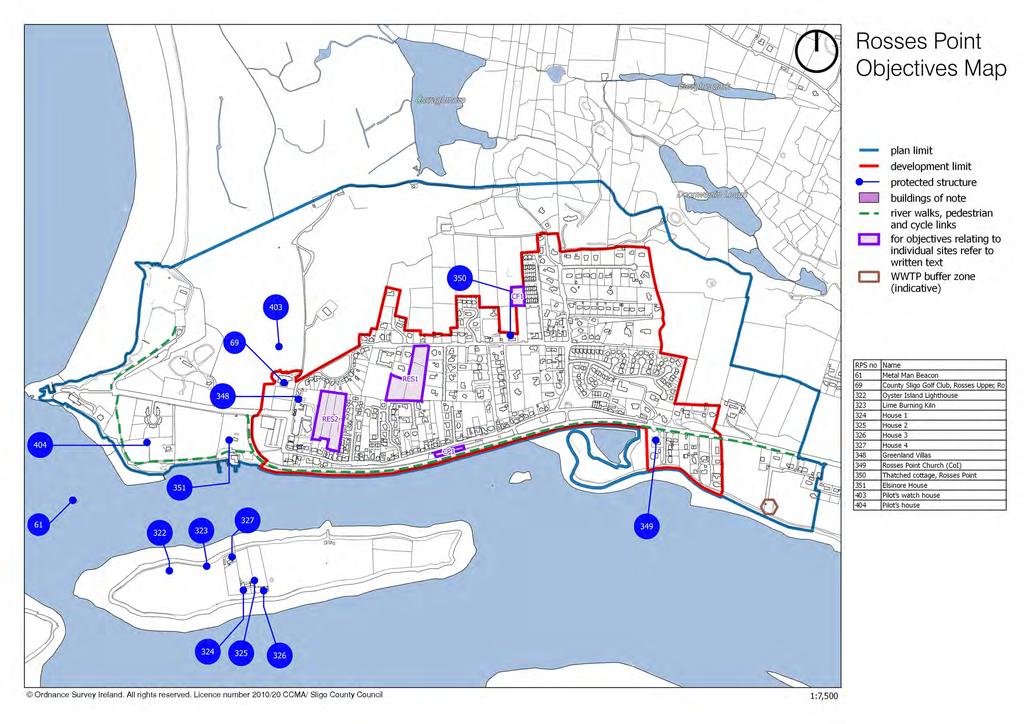
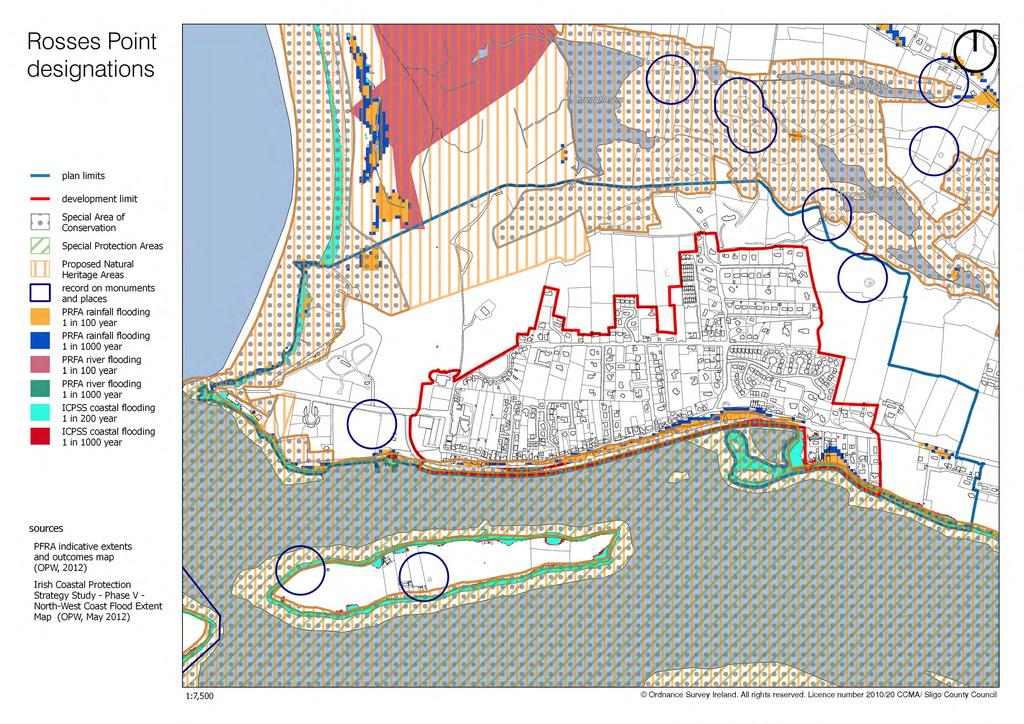
2 County Development Plan Volume 2, Chapter 31 Rosses Point Mini-Plan Commercial and enterprise development Commercial activities in the village are related to its significant tourism role. Enterprise is generally focused on the hospitality sector. The retail offer is limited, given the size of this settlement. A flexible and supportive approach will be adopted towards the provision of additional services in the village. Infrastructure Rosses Point is served by the regional road R-291, which links to the N-15 Sligo-Dublin road and to Sligo City. The water supply is sourced from Kilsellagh. The existing wastewater facilities are overloaded, particularly during peak tourist season. Sligo County Council, in conjunction with Irish Water, is considering the options available for the provision of wastewater services to the areas of Rosses Point, Cregg and Ballincar. Objectives Note: These objectives must be considered in conjunction with the policies and objectives contained in Volume 1 and the general policies for mini-plans contained in Chapter 1 of Volume 2 of this Plan. It is an objective of Sligo County Council to: 31.1 Natural heritage and open space A. Encourage the protection and enhancement of the conservation value of Cummeen Strand / Drumcliff Bay (Sligo Bay) SAC/pNHA and Cummeen Strand SPA. B. Encourage improved access to the seashore by providing walkways/open spaces and the enhancing/extending the existing seashore walk (as indicated on the Objectives Map) and by requiring the provision of such links in conjunction with the development of adjoining lands, subject to Habitats Directive Assessment. C. Generally retain land between the built-up area and the coastline free from development, in order to ensure that visually vulnerable coastal lands are protected and to assist in the conservation of adjacent designated sites. 2
3 31.2 Built heritage County Development Plan Volume 2, Chapter 31 Rosses Point Mini-Plan A. To seek the protection and conservation of the following Protected Structures located within the plan limit: RPS-69 County Sligo Golf Club (south façade), Rosses Upper RPS-348 Greenland Villas, Rosses Upper RPS-349 Rosses Point Church (CoI), Rosses Upper RPS-350 Thatched Cottage, Rosses Upper RPS-351 Elsinore House, Rosses Upper RPS-403 Pilot s Watch House, Rosses Upper RPS-404 Pilot s Watch House, Rosses Upper RPS-405 Five-bay, two-storey house, Lower Rosses B. Facilitate a range of potential uses (particularly tourism-related) as a means toward the renovation and redevelopment of Elsinore House (County RPS No. 351). C. Require any development proposal involving a Building of Note (as indicated on the Objectives Map) to restore or renovate the building in a sensitive manner that will contribute to the preservation and enhancement of the character of the building and its setting. D. Ensure that new development within the village centre reflects and enhances the existing streetscape character in accordance with the policies set out in Chapter 12 (Urban design) and the requirements of Section Development in historic streetscapes (development management standards) of this Plan. E. In order to retain the character and rhythm of the existing historical streetscape, require the retention and refurbishment of existing properties along the old village (upper) road rather than demolition and reconstruction Circulation and parking A. Encourage the improvement of pedestrian links between the village and surrounding natural amenities, particularly in conjunction with the development of relevant lands. B. Encourage a pedestrian link between Radharc na Ri housing estate and Rosses Point National School. The link should be provided via the site marked RES-1 on the Objectives Map. C. Prepare a traffic management plan for Rosses Point in accordance with the requirements of the Design Manual for Urban Roads and Streets (DMURS 2013), as resources permit. The plan should address the issue of conflict between pedestrian and vehicular traffic along the old village road and should investigate the feasibility of restricting traffic movements along this road. Facilities for pedestrians and cyclists should be prioritised. Traffic calming measures for the Promenade road should be investigated as part of an overall approach towards improving the environmental quality of the Promenade area and the adjoining open spaces and walkways. Development proposals will be required to incorporate the recommendations contained in the traffic management plan. 3
4 County Development Plan Volume 2, Chapter 31 Rosses Point Mini-Plan D. Reserve land for the accommodation of additional car-parking demands on the site marked CP-1. E. In cases where on-site car-parking requirements cannot be fully provided in the village centre area, shortfalls may be accommodated subject to satisfactory alternative proposals such as the payment of a financial contribution or the provision of parking at another suitable location. F. Maintain and enhance the existing commuter cycling route which links the village with Sligo City. Compliance with this objective will be required in conjunction with any development on adjoining lands Village-centre mixed-use zones A. Encourage an appropriate mix of uses along the old village road, in order to protect the vitality and viability of the village centre. B. Ensure that development within the village centre area is appropriately scaled, generally restricted to two storeys in height and designed to be in keeping with the character of existing development. C. Encourage a range of services within the village centre, particularly tourism-related ones Community facilities A. Support the development of playground facilities at the western end of the development limit, on lands zoned as open space to the south and west of the existing tennis courts / car park. B. Promote the development of the existing scout hall. C. Facilitate the potential expansion of the graveyard onto lands marked CF Tourism A. Support the further development and enhancement of existing tourism-generating facilities such as County Sligo Golf Club and Sligo Yacht Club. B. Facilitate the enhancement of the caravan park site at the western end of the village. Consideration will also be given to alternative tourism-related activities on this site, subject to appropriate scale, siting, design and Habitats Directive Assessment. C. Facilitate the continued development of the existing harbour and associated emergency services, subject to Habitats Directive Assessment Residential development A. The sites marked RES-1 and RES-2 are identified as having potential for co-ordinated residential development. Any development on these sites will only be permitted on the basis of a masterplan based on land assembly. Higher densities may be permitted, subject to appropriate siting, layout and design. 4
5 31.8 Wastewater treatment County Development Plan Volume 2, Chapter 31 Rosses Point Mini-Plan A. Reserve land at the existing wastewater treatment plant site to facilitate the provision of upgraded wastewater infrastructure to serve the village. B. Enhance the landscaping at the site of the proposed upgraded wastewater infrastructure. E. A buffer zone shall apply in the vicinity of the WWTP site. Development within this zone may be restricted or prohibited in the interest of public health and the protection of residential amenities. The extent of development restrictions in each case will be assessed at planning application stage. 5


6 County Development Plan Volume 2, Chapter 31 Rossess Point Mini-Plan Buildings of Note BoN No. 1 Six-bay, two-storey hotel Architecturally valuable features - roof pitch; decorative chimneys on ridge of roof; sash windows on ground floor; - front boundary wall and first floor railings. This symmetrical hotel building is typical of a mid-19-century coastal hotel and adds to the character of the village. Recommendation: The replacement of all the windows with timber sliding sash windows would greatly enhance the character of this building. BoN No. 2 Four-bay, single-storey cottage Architecturally valuable features - roof pitch; chimneys on ridge of roof; - sash windows; cast-iron finial on porch roof; This house presents a traditional façade to the Upper Road of Rosses Point and adds character to the streetscape. Recommendation: The architecturally valuable features of this cottage should be retained and restored. 6
7
8
9
10
Chapter 7. Transportation. Transportation Road Network Plan Transit Cyclists Pedestrians Multi-Use and Equestrian Trails
 Chapter 7 Transportation Transportation Road Network Plan Transit Cyclists Pedestrians Multi-Use and Equestrian Trails 7.1 TRANSPORTATION BACKGROUND The District of Maple Ridge faces a number of unique
DESIGN CODE. Enterprise West Harlow London Road North Design Code 21
 DESIGN CODE Enterprise West Essex @ Harlow London Road North Design Code 21 4 MAXIMUM BUILDING HEIGHTS 4.1 Table 4A sets out maximum building height standards for each character area within the LDO boundary.
CITY OF COCOA BEACH 2025 COMPREHENSIVE PLAN. Section VIII Mobility Element Goals, Objectives, and Policies
 CITY OF COCOA BEACH 2025 COMPREHENSIVE PLAN Section VIII Mobility Element Goals, Objectives, and Policies Adopted August 6, 2015 by Ordinance No. 1591 VIII MOBILITY ELEMENT Table of Contents Page Number
summary of issues and opportunities
 1 summary of issues and opportunities EXECUTIVE SUMMARY CHAPTER 2: HISTORY - 3: LAND USE This first chapter is an overview of lessons learned from analysis of the existing conditions on El Camino as well
Douglas Land Use and Transportation Strategy (DLUTS) Summary. August 2013
 Summary. August 2013") Douglas Land Use and Transportation Strategy (DLUTS) Summary August 2013 Background Douglas is a large and popular residential suburb of approximately 30,000 persons on the periphery of Cork City along
Douglas Land Use and Transportation Strategy (DLUTS) Summary August 2013 Background Douglas is a large and popular residential suburb of approximately 30,000 persons on the periphery of Cork City along
Comments The Plan for Port Whitby
 Comments The Plan for Port Whitby April 24th, 2013 Community Meeting #2 Summary Report Prepared by GLPi April 29th, 2013 1 Introduction The purpose of the Port Whitby Secondary Plan Update, Community Improvement
Community Improvement Plans: Creating walkable and liveable communities that support local business
 Community Improvement Plans: Creating walkable and liveable communities that support local business Kate Hall Program Manager ~ WALK Friendly Ontario Canada Walks, Green Communities Canada khall@greencommunitiescanada.org
21.07 TRANSPORT CONNECTIVITY AND INFRASTRUCTURE
 21.07 TRANSPORT CONNECTIVITY AND INFRASTRUCTURE 21.07-1 Connectivity and Choice Transport connectivity and mode choice are critical to achieving productive, sustainable and socially just cities. Travel
Harriet Fraser Traffic Engineering & Transportation Planning
 Appendix 5: Traffic Assessment 71 26 February 2015 Mr James Beban Senior Resource Consents Planner Cuttriss Consultants Ltd PO Box 30429 Lower Hutt PO Box 40170 Upper Hutt 5140 P 04 526 2979 M 027 668
SIGNS - RULES Signs - Rules Structure of the Rules Section Activities Discretionary Activities
 Attachment C.2 Signs - Rules.2.1 Structure of the Rules Section Four Activity Tables Commercial, Residential and Other group the District Plan zones. Each Activity Table contains rules relevant to the
The Rower Traffic Management Scheme
 KILKENNY COUNTY COUNCIL Comhairle Chontae Chill Chainnigh Section 38 of the Road Traffic Act, 1994 as amended by the Public Transport Regulation Act, 2009 (Section 46) The Rower Traffic Management Scheme
9. Parking Supporting Statement
 9. Parking Supporting Statement Content 1. Setting the Scene 2. Vision 3. Parking and the Shared Priorities 4. Issues 5. Delivery Programme in the first Plan Period 2001/02 2005/06 6. Good Practice 7.
Exhibit 1 PLANNING COMMISSION AGENDA ITEM
 Exhibit 1 PLANNING COMMISSION AGENDA ITEM Project Name: Grand Junction Circulation Plan Grand Junction Complete Streets Policy Applicant: City of Grand Junction Representative: David Thornton Address:
Additional Policies & Objectives for Local Area Plans Ashbourne LAP. Ashbourne
 Ashbourne Strategic Policies SP 1 To operate an Order of Priority for the release of residential lands in compliance with the requirements of CS OBJ 6 of the County Development Plan as follows: i) The
DRAFT for a State Policy for Healthy Spaces and Places
 DRAFT for a State Policy for Healthy Spaces and Places 1 DRAFT State Policy for Healthy spaces and Places 1. Purpose To encourage the use and development of land that builds healthy communities through
Additional Policies & Objectives for Local Area Plans Ashbourne LAP. Ashbourne
 Ashbourne Strategic Policies SP 1 To operate an Order of Priority for the release of residential lands in compliance with the requirements of CS OBJ 6 of the County Development Plan as follows: i) The
TRAVEL PLAN: CENTRAL EUROPEAN UNIVERSITY CAMPUS REDEVELOPMENT PROJECT TRAVEL PLAN. Central European University Campus Redevelopment Project.
 TRAVEL PLAN Central European University Campus Redevelopment Project Page 1 Table of Contents Introduction... 3 Background... 7 Building Users... 7 Transportation in Community Consultation... 7 Summary
Newcastle Racecourse Masterplan. 1 Introduction. Completing the vision of a redeveloped Newcastle Racecourse Welcome to our exhibition.
 1 Introduction Completing the vision of a redeveloped Newcastle Racecourse Welcome to our exhibition. Please take a look at our information boards and feel free to ask members of the project team any questions
OPEN HOUSE WELCOME Bronte Village Growth Area Review
 OPEN HOUSE WELCOME Bronte Village Growth Area Review Bronte Village is a growth area. Learn more! Introduction Bronte Village is a growth area. What is that? Bronte Village is one of six growth areas identified
Part B Design Guidance / Principles _
 Part B Design Guidance / Principles www. landlab.co.nz Queenstown Town Centre Public Realm Design Guidelines Version 7 14 June 2018 Page 006 B1 Design Guidance & Best Practice The Queenstown Town Centre
National Report of Greece. The city of Kalamaria is the reference area for all street cases, and is therefore described only once, in this chapter.
 9. REFERENCE AREA The city of Kalamaria is the reference area for all street cases, and is therefore described only once, in this chapter. 9.1 Area and Data Description The city of Kalamaria covers an
Chapter 3: Multi-Modal Circulation and Streetscapes
 CHAPTER 3: MULTI-MODAL CIRCULATION AND STREETSCAPES Chapter 3: Multi-Modal Circulation and Streetscapes Overview Streetscape improvements have already been completed for Depot Street between Main Avenue
NUMBER PROJECT TITLE ESTIMATED COST
 NUMBER PROJECT TITLE ESTIMATED COST PROJECT CATEGORY DESCRIPTION TBD= To be determined 1 Art in Pedestrian Underpass $70,000 Culture and Recreation A public art mural in accordance with the Public Art
CONNECTING PEOPLE TO PLACES
 CONNECTING PEOPLE TO PLACES 82 EAST BENCH MASTER PLAN 07 Introduction The East Bench transportation system is a collection of slow moving, treelined residential streets and major arteries that are the
2.0 Ballpark District
 2.0 Ballpark District 2.1 Introduction The Ballpark District is located in the south central portion of the City of Lake Elsinore, just north of the City limit line in this area. The Ballpark District
Bentleigh GLEN EIRA COUNCIL TRANSFORMATIONAL CONCEPTS 15
 2 Bentleigh GLEN EIRA COUNCIL TRANSFORMATIONAL CONCEPTS 15 Bentleigh Bentleigh urban design context The Bentleigh activity centre is a busy strip shopping centre that runs along Centre Road and is dissected
Standing Committee on Policy and Strategic Priorities. Mount Pleasant Industrial Area Parking Strategy and Access Improvements
 POLICY REPORT Report Date: April 23, 2018 Contact: Lon LaClaire Contact No.: 604.873.7722 RTS No.: 9944 VanRIMS No.: 08-2000-20 Meeting Date: May 16, 2018 TO: FROM: SUBJECT: Standing Committee on Policy
West Dimond Blvd Upgrade Jodhpur Street to Sand Lake Road
 West Dimond Blvd Jodhpur St to Sand Lake CSS Transportation Project Summary Municipality of Anchorage Project # 05 005 Project Manager: John Smith, P.E. (MOA PM&E) Project Administrator: Julie Makela,
Solana Beach Comprehensive Active Transportation Strategy (CATS)
") Solana Beach Comprehensive Active Transportation Strategy (CATS) 3.0 Goals & Policies The Solana Beach CATS goals and objectives outlined below were largely drawn from the Solana Beach Circulation Element
Solana Beach Comprehensive Active Transportation Strategy (CATS) 3.0 Goals & Policies The Solana Beach CATS goals and objectives outlined below were largely drawn from the Solana Beach Circulation Element
Plant City Walk-Bike Plan
 Plant City Walk-Bike Plan Plant City Commute Mode Share 2.2% 1.4% 2.9% Drove alone 10.2% Carpooled Public transportation (0.1%) Walked Used a Bike (0.4%) 82.9% Taxicab, motorcycle, or other means Worked
Walking and urban planning. Maurizio TIRA Environmental Engineer, Full Professor of Town and regional planning Università degli Studi di Brescia
 Walking and urban planning Environmental Engineer, Full Professor of Town and regional planning Università degli Studi di Brescia The presentation analyses the main obstacles to walking and shows how planning
APPELLANT S STATEMENT OF CASE
 TOWN & COUNTRY PLANNING ACT 1990 (AS AMENDED) APPEAL BY FOCUS INTERNATIONAL CHRISTIAN CENTRE (FICC) AGAINST REFUSAL OF PLANNING PERMISSION BY THE LONDON BOROUGH OF HILLINGDON PLANNING PERMISSION IS SOUGHT
Delivering the. Strategy 7.0
 7.0 Delivering the Strategy 7.1 Introduction This chapter presents a framework for the delivery of the strategy. Key challenges and opportunities are identified that will have an impact on the successful
Speed Limit Policy Isle of Wight Council
 APPENDIX B Speed Limit Policy Isle of Wight Council 2009 Contents Section 1 Introduction 1.1 Links with the Local Transport Plan Section 2 Speed Limits on Urban Roads and Residential Areas 2.1 20mph Limits
TRANSPORT AND MOVEMENT
 TRANSPORT AND MOVEMENT Movement Strategy Public Transport Cycling and Walking Road Network Parking Standards Transport Impact Assessments Traffic Management Policies DRAFT POOLBEG PLANNING SCHEME Movement
Naas to Kill Cycle Scheme - Reference P
 Naas to Kill Cycle Scheme - Reference P82017.014 Kildare County Council October 2017 Document history Job number: 5139616 Document ref: 5139616DG017 Revision Purpose description Originated Checked Reviewed
Public Consultation on Braintree Integrated Transport Package (ITP) HAVE YOUR. Consultation open from 24 September to 5 November 2018 SAY
 HAVE YOUR. Consultation open from 24 September to 5 November 2018 SAY") Public Consultation on Braintree Integrated Transport Package (ITP) HAVE YOUR SAY Consultation open from 24 September to 5 November 2018 Contents Introduction 3 Background 4 Springwood Drive Roundabout
Public Consultation on Braintree Integrated Transport Package (ITP) HAVE YOUR SAY Consultation open from 24 September to 5 November 2018 Contents Introduction 3 Background 4 Springwood Drive Roundabout
Report. Typical Sections. City of Middleton, WI
 Report Typical Sections City of Middleton, WI December 2006 Report for City of Middleton, Wisconsin Typical Sections repared by: Traffic Associates LLC and STRAND ASSOCIATES, INC. 910 West Wingra Drive
The boards contain our dra Vision & Objec ves for Danbury.
 Welcome Thank you for visi ng today The boards contain our dra Vision & Objec ves for Danbury. We are also displaying a map of Danbury showing the sites that have been put forward to build the 100 new
Obey Creek PEDESTRIAN CIRCULATION EAST WEST PARTNERS PEDESTRIAN CIRCULATION CREEK SIDE LANE SLIP STREET SCOTT MURRAY MAIN STREETS EAST/WEST
 THE VILLAGE AT PEDESTRIAN CIRCULATION MAIN STREETS NORTH/SOUTH MAIN STREETS EAST/WEST SLIP STREET CREEK SIDE LANE PEDESTRIAN CIRCULATION DESCRIPTION: Circulation through the downtown of is organized by
East Burke Transportation, Safety and Capacity Improvements
 East Burke Transportation, Safety and Capacity Improvements The purpose of this project is to increase mobility and improve safety for pedestrians, cyclists, and motor vehicles along VT Route 114 in the
Much Wenlock Neighbourhood Plan Land and Premises Availability Assessment
 How to submit a site Much Wenlock Neighbourhood Plan Land and Premises Availability Assessment Guidance Notes for completing the form Please use the attached form to suggest sites or premises that you
PAGHAM NEIGHBOURHOOD PLAN INFRASTRUCTURE GROUP
 PAGHAM NEIGHBOURHOOD PLAN INFRASTRUCTURE GROUP SUMMARY OF FINDINGS AND PRIORITIES PARKING There was a high level of response to this topic which included many aspirations to provide car parking near to
EXECUTIVE SUMMARY: TRANSIT-ORIENTED DEVELOPMENT IN SMITHS FALLS, ONTARIO; A COMPARISON BETWEEN TWO SITES
 EECUTIVE SUMMARY: TRANSIT-ORIENTED DEVELOPMENT IN SMITHS FALLS, ONTARIO; A COMPARISON BETWEEN TWO SITES Topic and Purpose In 2007, the Mayor of Ottawa s Task Force on Transportation suggested adding a
Transportation Corridor Studies: Summary of Recommendations
 Transportation Corridor Studies: Summary of Recommendations Route 4 Corridor Study: Route 10 Corridor Study: Route 44 Corridor Study: Route 175 Corridor Study: Route 5/15 Corridor Study: Rentschler Field
The role of the Authority in promoting sustainable transport. Gerry Murphy South East Regional Assembly 27 th May 2011
 The role of the Authority in promoting sustainable transport Gerry Murphy South East Regional Assembly 27 th May 2011 Who we are National Transport Authority established on 1 st December 2009 Dublin Transport
Active Transportation Infrastructure Investment A Business Case
 Active Transportation Infrastructure Investment A Business Case In 2016, the Real Estate Foundation awarded the Capital Regional District a $50,000 grant for Shifting Gears: Land Use Change through Active
I418 Kingseat Precinct
 I418. Kingseat I418.1. Precinct Description The Kingseat Precinct covers some 298 hectares. It adjoins the Whatapaka Creek of the Manukau Harbour (which is of significant importance to the Mana whenua
ACTIVE TRANSPORTATION
 ACTIVE TRANSPORTATION Mobility 2040 Supported Goals Improve the availability of transportation options for people and goods. Support travel efficiency measures and system enhancements targeted at congestion
Proposed Amendment to the City-Wide Trails Plan
 Proposed Amendment to the City-Wide Trails Plan Planning and Zoning Commission June 23, 2015 Comprehensive Plan 2010 Sustainable Community Recommendations 2 Goal: Walking and Cycling are Encouraged throughout
Active Travel Towns Funding Scheme Project Proposal. Sligo. Sligo Local Authorities
 Active Travel Towns Funding Scheme 2014-2016 Project Proposal for Sligo by Sligo Local Authorities Introduction Over the last two years, Sligo Local Authorities have implemented years 1 & 2 of their 5
Tonight is for you. Learn everything you can. Share all your ideas.
 Strathcona Neighbourhood Renewal Draft Concept Design Tonight is for you. Learn everything you can. Share all your ideas. What is Neighbourhood Renewal? Creating a design with you for your neighbourhood.
Douglas Land Use and Transportation Study
 Douglas Land Use and Transportation Study Summary: Key: Yellow Box = key project information Green Box = project recommendations Grey Box = anticipated project outcomes Background: It is an objective of
1 VicRoads Access Management Policies May 2006 Ver VicRoads Access Management Policies May 2006 Version 1.02
 1 VicRoads Access Management Policies May 2006 Ver 1.02 VicRoads Access Management Policies May 2006 Version 1.02 2 VicRoads Access Management Policies May 2006 Ver 1.02 FOREWORD FOR ACCESS MANAGEMENT
WEST CENTRAL DRAFT DISTRICT PLAN SUBMISSION 3 HASSAL ST WESTMEAD
 Ref: OBF 170330 LGSC - DDP Sub 30 March 2017 Greater Sydney Commission PO Box 257 PARRAMATTA NSW 2124 Attention: District Commissioner - Professor Edward Blakely Dear Professor Ed Blakeley, WEST CENTRAL
Transit boulevard: A new road type for Sydney s Growth Centres
 Transit boulevard: A new road type for Sydney s Growth Centres Cleaver, M. A., de Roos, M. P., NSW Centre for Road Safety, Roads and Traffic Authority, NSW Collins, G., Network Services, Roads and Traffic
Voting should indicate preference to one option (Option 1, Option 2, or Option 3)
") Proposals for Wied Il-Buni Options being considered for proposal for the Ministry of Infrastructure to be taken up with Transport Malta following the extension of Terminal 1 by Malta Freeport Corporation.
Proposals for Wied Il-Buni Options being considered for proposal for the Ministry of Infrastructure to be taken up with Transport Malta following the extension of Terminal 1 by Malta Freeport Corporation.
Vision: Traditional hamlet with an attractive business/pedestrian friendly main street connected to adjacent walkable neighborhoods
 N D. Focus Area II Vision: Traditional hamlet with an attractive business/pedestrian friendly main street connected to adjacent walkable neighborhoods Transit Road Focus Area II is located in the Hamlet
TRANSPORTATION NEEDS ASSESSMENT
 TRANSPORTATION NEEDS ASSESSMENT A travel demand analysis was carried out to determine the operational issues and the potential benefit that adding traffic capacity would have on the road network. All the
North Coast Corridor:
 North Coast Corridor: Connecting People, Transportation & Environment Legislative Hearing: 11.8.10 1 North Coast Corridor Region s Lifeline A Regional Strategy Mobility, Economy & Environment North Coast
1.5 On this basis it is fundamental that the Transport Strategy for the site focuses on the following key criteria,
 1.0 Introduction 1.1 The Transport Assessment has been prepared on behalf of Eon and Roger Bullivant Ltd in respect of the proposed mixed use sustainable urban extension of Drakelow Park. 1.2 The methodology
Launceston's Transport Futures. Greater travel options for the people of Launceston
 Launceston's Transport Futures Greater travel options for the people of Launceston Final Draft 13 Jan 2014 1 Page Number Executive summary 3 What is Transport Futures? 4 Vision 6 Economy, access and liveability
Wyldewood Estates. Pre-Application Public Engagement Summary of Issues and Responses
 Wyldewood Estates Pre-Application Public Engagement Summary of Issues and Responses March 2016 Executive Summary Morguard Residential Properties has been thoughtfully planning the redevelopment of Wyldewood
MASTER PLAN October 2017
 MASTER PLAN October 2017 1 2 MASTER PLAN OCTOBER 2017 Contents Introduction 4 Developing The Master Plan 4 Background 5 Vision (20 40 years) 5 Strategy Plan 5 Context 6 Key Issues 7 Opportunities 8 Recommendations
With the departure of large-scale maritime activities and the redevelopment of Docklands, the Liffey can and will change character.
 6. Animate THE WATER With the departure of large-scale maritime activities and the redevelopment of Docklands, the Liffey can and will change character. The city s residents can colonise the water, turning
Warfield Neighbourhood Plan: 4.4 Infrastructure
 Warfield Neighbourhood Plan: 4.4 Infrastructure Previously decided Policy headings: Policy WNP16 Transport Impact of Development Policy WNP17 Transport Proposals Policy WNP18 New School Buildings Policy
Wicklow County Council Chomairle Chontae Chill Mhantáin. Traffic Calming Policy
 Chomairle Chontae Chill Mhantáin Adopted by Wicklow County Council on the 11th of June, 2012 Contents Section Page 1. Introduction 3 2. Legislation 3 3. Guidance Documentation 3 4. Policy Objectives &
GLEN EIRA CITY COUNCIL. MURRUMBEENA Transforming our neighbourhood together our concepts based on your ideas
 GLEN EIRA CITY COUNCIL MURRUMBEENA Transforming our neighbourhood together our concepts based on your ideas 1 WHAT HAVE WE HEARD? WHAT NOW? Stage one Tell us what you love about your shopping strip November
Your views are important. Please fill in a form before you leave. Or alternatively
 Drum Property Group is delighted to welcome you to this exhibition which sets out our initial proposals for a mixed-use development at Stead s Place, Edinburgh. We are keen to hear the views of local people
Transportation Master Plan Advisory Task Force
 Transportation Master Plan Advisory Task Force Network Alternatives & Phasing Strategy February 2016 BACKGROUND Table of Contents BACKGROUND Purpose & Introduction 2 Linking the TMP to Key Council Approved
Living Streets Policy
 Living Streets Policy Introduction Living streets balance the needs of motorists, bicyclists, pedestrians and transit riders in ways that promote safety and convenience, enhance community identity, create
MOUNTAIN HOUSE SPECIFIC PLAN I 9.1 INTRODUCTION ASSUMPTIONS TRANSPORTATION FACILITIES TRANSPORTATION IMPROVEMENTS PHASING 9.
 CHAPTER NINE: TRANSPORTATION AND CIRCULATION 9.1 INTRODUCTION 9.1 9.2 ASSUMPTIONS 9.1 9.3 TRANSPORTATION FACILITIES 9.1 9.4 TRANSPORTATION IMPROVEMENTS PHASING 9.3 LIST OF FIGURES LIST OF TABLES Figure
CAIRNGORMS NATIONAL PARK AUTHORITY FOR DECISION
 CAIRNGORMS NATIONAL PARK AUTHORITY FOR DECISION Title: Prepared by: A9 Dualling Project: Dalraddy to Slochd Murray Ferguson, Director of Planning and Rural Development and Gavin Miles, Head of Planning
Town of Kiawah Island Board of Zoning Appeals
 Town of Kiawah Island Board of Zoning Appeals March 19, 2018 Town of Kiawah Island Municipal Center 4475 Betsy Kerrison Parkway Kiawah Island, SC 29455 CASE# BZA-12-17-00233 Applicant/Property Owner(s):
CITY OF BLOOMINGTON COMPLETE STREETS POLICY
 CITY OF BLOOMINGTON COMPLETE STREETS POLICY POLICY OBJECTIVE: The City of Bloomington will enhance safety, mobility, accessibility and convenience for transportation network users of all ages and abilities,
CHAPTER 7.0 IMPLEMENTATION
 CHAPTER 7.0 IMPLEMENTATION Achieving the vision of the Better Streets Plan will rely on the ability to effectively fund, build and maintain improvements, and to sustain improvements over time. CHAPTER
Implementation Matrix
 Downtown Delaware Parking Study Short Term Mid Term Long Term = Within one year = Within three years = More than three years The highlighted proposed enhancements will require a substantial amount of input
o n - m o t o r i z e d transportation is an overlooked element that can greatly enhance the overall quality of life for the community s residents.
 N o n - m o t o r i z e d transportation is an overlooked element that can greatly enhance the overall quality of life for the community s residents. 84 Transportation CHAPTER 11 INTRODUCTION Transportation
TRAFFIC IMPACT STUDY CRITERIA
 Chapter 6 - TRAFFIC IMPACT STUDY CRITERIA 6.1 GENERAL PROVISIONS 6.1.1. Purpose: The purpose of this document is to outline a standard format for preparing a traffic impact study in the City of Steamboat
FAQ s Walsh Road / Ferguson Road Pilot Scheme
 FAQ s Walsh Road / Ferguson Road Pilot Scheme What is happening? Traffic calming measures are being installed as a pilot. Temporary Bollards will be installed to the east of 1 Ferguson Road and a Temporary
Welcome. If you have any questions or comments on the project, please contact:
 Welcome This drop-in public open house is intended to provide information about the Bay Street bike lanes project. This project proposes a dedicated cycling facility along Bay Street between Aberdeen Avenue
University of Victoria Campus Cycling Plan Terms of Reference. 1.0 Project Description
 University of Victoria Campus Cycling Plan Terms of Reference 1.0 Project Description The Campus Cycling Plan, a first for the University, will provide a comprehensive and coordinated approach to support
Executive Summary Route 30 Corridor Master Plan
 Route Corridor Master Plan Project Overview The Route Corridor Master Plan is a coordinated multimodal transportation and land use plan for the entire stretch of Route through East Whiteland Township,
Clackamas County Comprehensive Plan
 ROADWAYS The County s road system permits the movement of goods and people between communities and regions, using any of a variety of modes of travel. Roads provide access to virtually all property. They
Amendments to Essex Highway Maintenance Strategy Maintenance Policy and Standards April 2008
 Amendments to Essex Highway Maintenance Strategy Maintenance Policy and Standards April 2008 The following amendments to the wording of the maintenance strategy apply following the revised maintenance
HISTON ROAD Have your say on better public transport, cycling and walking journeys
 HISTON ROAD Have your say on better public transport, cycling and walking journeys Have your say: Please complete the survey inside this leaflet or online at www.greatercambridge.org.uk/histonconsultation
High frequency bus services operating to Little Island; Creation of a new Park and Ride site and train station at North Esk;
 Cork County Council 7 th December 2018 Dear Adrian O Neill (aoneill@jbbarry.ie) The Transport and Mobility Forum, Cork (TMF) is a representative group of organisations who have a common interest in sustainable
5 Circulation & Parking
 5 Circulation & Parking Downtown Parking & Circulation Strategy. Downtown Wayne has a somewhat disconnected system of local public streets to connect downtown with the residential neighborhoods, and primary
Section 14B Purpose of the Suburban Residential Zone and the Large Lot Residential Zone
 Section 14B 14B Purpose of the Suburban Residential Zone and the Large Lot Residential Zone The purpose of the Suburban Residential Zone is to provide for low density suburban residential development in
National Cycle Network Funding Scheme 2012/2012 Application Form. Waterford City Council. Paul Cleary, Executive Engineer. 3.2km 289, ,000
 National Cycle Network Funding Scheme 2012/2012 Application Form Section 1:Project Outline Name and Address of Local Authority Contact person/proposed project manager Waterford City Council Paul Cleary,
Background paper (Local Government Act 1972 Section 100D)
") ITEM 13 APPLICATION NO. 12/01822/VARS APPLICATION TYPE VARIATION OF CONDITIONS - SOUTH REGISTERED 24.08.2012 APPLICANT Brook Enterprises Ltd SITE Dunwood Manor Golf Club, Danes Road, Awbridge, AWBRIDGE
ITEM 13 APPLICATION NO. 12/01822/VARS APPLICATION TYPE VARIATION OF CONDITIONS - SOUTH REGISTERED 24.08.2012 APPLICANT Brook Enterprises Ltd SITE Dunwood Manor Golf Club, Danes Road, Awbridge, AWBRIDGE
Strategic Plan
 Strategic Plan 2016-2020 President s Message On behalf of the Board and staff I am very pleased to present the Ballarat Golf Club Strategic Plan 2016-2020 (the Plan) to the members. The Plan has been
This page intentionally left blank.
 This page intentionally left blank. COMMUNITY Coweta Community Overview Coweta Coweta, a residential community located in Wagoner County, is a suburb of Tulsa situated southeast of the metropolitan area
ARLINGTON COUNTY, VIRGINIA
 ARLINGTON COUNTY, VIRGINIA County Board Agenda Item Meeting of October 15, 2016 DATE: October 7, 2016 SUBJECT: Adoption of amendments to the Master Transportation Plan (MTP) to create a new Pedestrian
Section VIII Community Design
 Section VIII Community Design Overview Town and village centers are critically important to communities. They are the centers of commerce. They are the places where residents and visitors seek and receive
Infrastructure Policies
 Infrastructure Policies 1. Primary Healthcare Health facilities in Ashtead comprise, Ashtead Private Hospital, two GP surgeries at Gilbert House and St Stephens, two Dental practices, the Arch and Tudor
COUNCIL POLICY NAME: COUNCIL REFERENCE: 06/119 06/377 09/1C 10llC 12/1C INDEX REFERENCE: POLICY BACKGROUND
 COUNCIL POLICY NAME: COUNCIL ADVISORY COMMITTEES - TERMS OF REFERENCE ISSUED: APRIL 3, 2006 AMENDED: NOVEMBER 27, 2006 NOVEMBER 23, 2009 JANUARY 11, 2010 DECEMBER 17, 2012 POLICY COUNCIL REFERENCE: 06/119
162 RESIDENTS ATTENDED 2 DAYS OF WORKSHOPS 15 TABLE DISCUSSIONS WHAT WE HEARD. Oakridge Municipal Town Centre Workshops PLANNING PROGRAM
 OAKRIDGE MTC WORKSHOP 2017 CAMBIE CORRIDOR Phase 3 STEP 3: 3: October June 2017 CAMBIE CORRIDOR PLANNING PROGRAM 2 DAYS OF WORKSHOPS 15 TABLE DISCUSSIONS 162 RESIDENTS ATTENDED WHAT WE HEARD Oakridge Municipal
Streets for All : 9 Use of white lines
 Streets for All : 9 Use of white lines On 1st April 2015 the Historic Buildings and Monuments Commission for England changed its common name from English Heritage to Historic England. We are now re-branding
Transport Assessment Haine Road Ramsgate CT12 5ET
 Haine Road Ramsgate CT12 5ET September 2016 39 Cossington Road Canterbury Kent CT1 3HU Tel 01227 472128 www.rmbconsultants.co.uk This report has been prepared by in accordance with the instructions of